AVIRIS (Airborne Visible/Infrared Imaging Spectrometer)
Airborne Sensors
AVIRIS (Airborne Visible/Infrared Imaging Spectrometer)
Overview
AVIRIS, of AIS (Airborne Imaging Spectrometer) heritage, is a NASA/JPL-developed/owned instrument operated by NASA/JPL and flown aboard various aircraft types. The instrument measures transmitted, reflected, and scattered solar energy from the Earth's surface and atmosphere in 224 channels over extended regions at high spatial and spectral resolutions. AVIRIS is regarded as the first operational hyperspectral instrument. 1)
Science objectives: AVIRIS radiance spectra are used to identify, measure and monitor constituents of the Earth's surface and atmosphere based on molecular absorption and particle scattering signatures. Research areas include: ecology, oceanography, geology, snow hydrology, cloud and atmospheric studies. AVIRIS data are also used for satellite calibration, modeling, algorithm development and validation. Research with AVIRIS is predominantly directed towards understanding processes related to the global environment and climate change.2) 3) 4) 5)
Background
In the early 1980s, Alexander F. H. Goetz and his colleagues at JPL started the development of the AVIRIS instrument. The goal was to introduce the newly available solid-state detector technology into remote sensing applications and to acquire detailed measurements (in many parallel bandpass channels) of the visible and SWIR (Short Wave Infrared) spectrum.
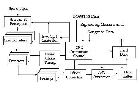
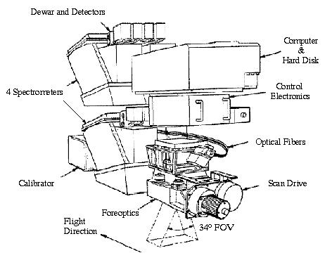
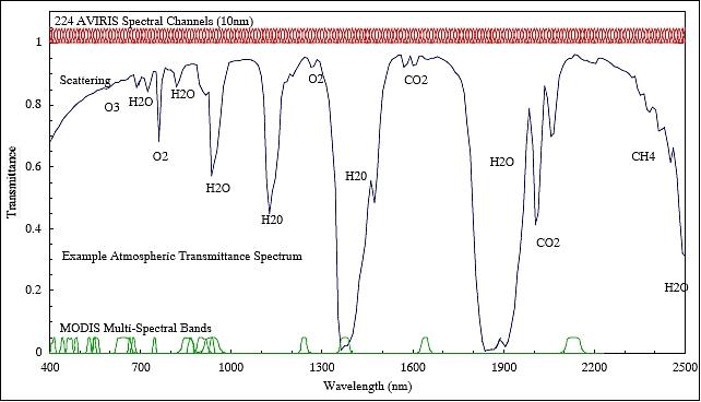
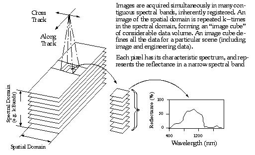
AVIRIS was flown for the first time in 1986 (first airborne images), first science data in 1987, fully operational since 1989. In June/July 1991 the instrument was flown over numerous European test sites in the framework of EMAC (European Multi-Sensor Airborne Campaign). AVIRIS uses scanning optics and a group of four spectrometers to image a 677 pixel swath width simultaneously in 224 contiguous spectral bands. A spatial image is built up through the scanner motion, which defines an image line 677 pixels wide perpendicular to the aircraft direction, and through the aircraft motion, which defines the length of the image frame. Sensor: optomechanical whiskbroom scanner (12 Hz) that uses line arrays of detectors to image a 677 pixel-wide swath in 224 contiguous bands (four grating spectrometers). Spectral range: 360 - 2500 nm with a total of 224 bands.
AVIRIS is now an operational instrument with reliable radiometric and spectral calibrations. AVIRIS typically acquires images with a pixel size of 20 m from a NASA ER-2 aircraft at an altitude of 20 km. The swath width on the ground is approximately 12 km. AVIRIS can also acquire images from a low-altitude aircraft at spatial resolutions of 1-4 m with reduced swath widths.
All AVIRIS data is decommutated and archived at JPL. Since 1989 over 4000 scenes (many TB) have been acquired (a scene consists of 677 pixels x 512 lines x 224 bands).
Parameter | Value | Parameter | Value |
Spectrometer A |
| Detectors of Spect. A |
|
Spectrometer B |
| Detectors of Spect. B |
|
Spectrometer C |
| Detectors of Spect. C |
|
Spectrometer D |
| Detectors of Spect. D |
|
Foreoptics | Pupil diameter=200 mm | Fiberoptics |
|
Swath width | 12 km (20 km altitude) | Spatial resolution | 20 m x 20 m |
Scanner rate | 12 scans/s | Pixels/scan line | 677 |
Quantization | 16 bit (from 2005 onwards) | Data rate | 4.5 MB/s |
Hard disk | 73 GB | SNR (@ 490 nm) | 100:1 |
Instrument mass | 340 kg | Instrument power | 28 VDC, 4 A |
Flight altitude | 3.8 to 20 km | Ground-track velocity | 145 - 760 km/h |
Velocity/height | 38 1/hr |
|
|
AVIRIS is of modular construction, consisting of six optical subsystems and five electrical subsystems. The optical subsystems (a whiskbroom scanner, four spectrometers, and a calibration source) are coupled together through optical fibers.
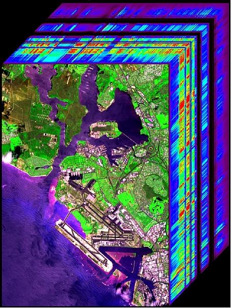
Data: The recorded data set forms an image cube of which two axes represent spatial dimensions, and the third represents a spectral dimension. The data recorder of AVIRIS was upgraded in 2005 (73 GByte storage capacity).
The general system performance of the instrument is continually being upgraded. In addition the ground data system at JPL was modernized and its functionality expanded to handle the large data volumes of the sensor expediently and to provide data retrieval. 6) 7) 8)
AVIRIS upgrades: New Lyot spectral calibration filters were installed in the AVIRIS calibrator in spring 1994 (improved spectral calibration). New focal planes with half the noise of the current focal planes were installed by the end of 1994 with 12 bit digitization capability; another upgrad to 16 bits followed in 2005.
Further AVIRIS upgrades: In 1999 AVIRIS was outfitted with a dedicated INS/GPS receiver system mounted on the foreoptics that enables delivery of georectified AVIRIS data. In addition, the baseline noise equivalent delta radiance (signal-to-noise) has been significantly improved for the spectral regions 650 to 1300 nm and 1900 to 2500 nm. Furthermore, a new foreoptics with twice the previous throughput performance was installed in 2004. 9) 10)
AVIRIS has been flown on four aircraft platforms: NASA's ER-2 jet, Twin Otter International's turboprop, Scaled Composites' Proteus, and NASA's WB-57. The ER-2 flies at approximately 20 km above sea level, at about 730 km/hr. The Twin Otter aircraft flies at 4 km above ground level at 130 km/h. AVIRIS has flown all across the US (including Hawaii), Canada, Europe, Southern Mexico, Brazil, Argentina, Puerto Rico, and the US Virgin Islands.

As of 2008, the AVIRIS instrument has been flown for 20 years in a multitude of campaigns in various parts of the world. AVIRIS and imaging spectroscopy are providing the basis for a step forward in Earth remote sensing in the solar reflected spectrum The range of research applications cover the following topics or support scenarios:
• Atmosphere: water vapor, clouds properties, aerosols, absorbing gases
• Ecology: chlorophyll, leaf water, lignin, cellulose, pigments, structure, non-photosynthetic constituents
• Geology and soils: mineralogy, soil type
• Coastal and inland waters: chlorophyll, plankton, dissolved organics, sediments, bottom composition, bathymetry
• Snow and ice hydrology: snow cover fraction, grain size, impurities, melting
• Biomass burning: subpixel temperatures and extent, smoke, combustion products
• Environmental hazards: contaminants directly and indirectly, geological substrate
• Calibration: aircraft and satellite sensors, sensor simulation, standard validation
• Modeling: radiative transfer model validation and constraint
• Commercial: mineral exploration, agriculture and forest status
• Algorithms: autonomous atmospheric correction, advance spectra derivation.
In the timeframe 2010/11, the AVIRIS instrument continuous to support campaigns for terrestrial ecology investigations. The measured spectra provide the basis for understanding the environment from a remote perspective based in the physics, chemistry and biology revealed by the spectral signatures. 12)

Legend to Figure 6: NPV corresponds to non-photosynthetic vegetation. A wide diversity of composition absorption and scattering signatures in nature are illustrated by these materials.
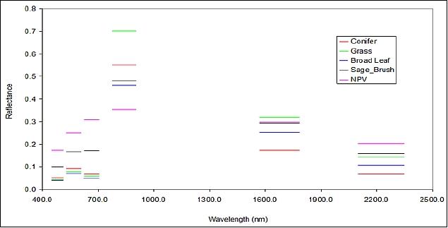
Legend to Figure 7: It can be seen that these discrete measurements are insufficient for de-convolving relevant chemical and biological species.
References
1) Special Issue on Imaging Spectroscopy - in particular AVIRIS (review article), Remote Sensing of Environment, Vol. 65, No 3, Sept. 1998, pp. 227-375
2) Information provided by Robert O. Green and Michael Eastwood of NASA/JPL
3) G. Vane, R. O. Green, et al., “The Airborne Visible/Infrared Imaging Spectrometer (AVIRIS),” Remote Sensing of Environment, Vol. 44, 1993, pp. 127-143
4) W. M. Porter, H. T. Enmark, “A System of the Airborne Visible/Infrared Imaging Spectrometer (AVIRIS),” SPIE, Vol. 834 Imaging Spectroscopy II, 1987
5) http://www.amesremote.com/section2.htm
6) W. M. Porter, T. G. Chrien, E. G. Hansen, Ch. M. Sature, “Evolution of the Airborne Visible/Infrared Imaging Spectrometer (AVIRIS) Flight and Ground Data Processing System,” SPIE, Vol. 1298, 1990, pp. 11-17
7) T. G. Chrien, et al., “Improvements to the Airborne Visible/Infrared Spectrometer (AVIRIS) Calibration System,” Proceedings of IGARSS '94, Volume IV, pp. 2293-2294
8) http://aviris.jpl.nasa.gov/html/aviris.overview.html
9) Information provided by Robert O. Green and Michael Eastwood of NASA/JPL
10) http://aviris.jpl.nasa.gov/html/aviris.instrument.html
11) R. O. Green, M. Eastwood, I. McCubbin, C. Chovit, J. Raney, J. Holbrook, et al., “Overview of AVIRIS Acquisitions
in Argentina as Part of the NM EO-1 Campaign in 2001, URL: https://web.archive.org/web/20130505034446/http://www.cossa.csiro.au/hswww/oz_pi/presentations/pres_argen_overview_011121.pdf
12) L. Hamlin, R. O. Green, P. Mouroulis, M. Eastwood, D. Wilson, M. Dudik, C. Paine, “Imaging Spectrometer Science Measurements for Terrestrial Ecology: AVIRIS and New Developments,” 2011 IEEE Aerospace Conference, Big Sky, MT, USA, March 5-12, 2011