AVIRIS-NG (Airborne Visible/Infrared Imaging Spectrometer-Next Generation)/NGIS
Airborne Sensors
AVIRIS-NG (Airborne Visible/Infrared Imaging Spectrometer-Next Generation) / NGIS
Overview
In 2007, the JPL team began to conceptualize the next generation of an airborne AVIRIS-like sensor (referred to as AVIRISng) based on input from the research community and potential partners. Internally funded efforts at JPL created progress in the system concepts for such a new sensor. The instrument team finalized the requirements and and design work and completed a design review in November 2009. The NGIS (Next Generation Imaging Spectrometer) design is one outcome of that work. The instrument has been built and integrated, the target completion date is mid-summer 2011. 1) 2)
The NGIS instrument is compatible with a broad array of possible aircraft platforms. Initial flights will take place in a Twin Otter turboprop at altitudes of ~10-15 km.
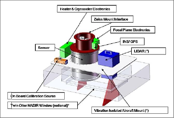
Major components of the flight package (Figure 1) include the sensor itself, which will be encased in a vacuum enclosure, high precision INS/GPS, focal plane electronics, On-Board Calibrator (OBC) electronics boxes, heaters boxes, and a vibration isolating aircraft mount. Accommodation has been made for companion instruments which may be flown in a co-boresighted configuration at the discretion of the project scientist, but are not part of this development. Companion instruments of value may include an optical camera or LIDAR.
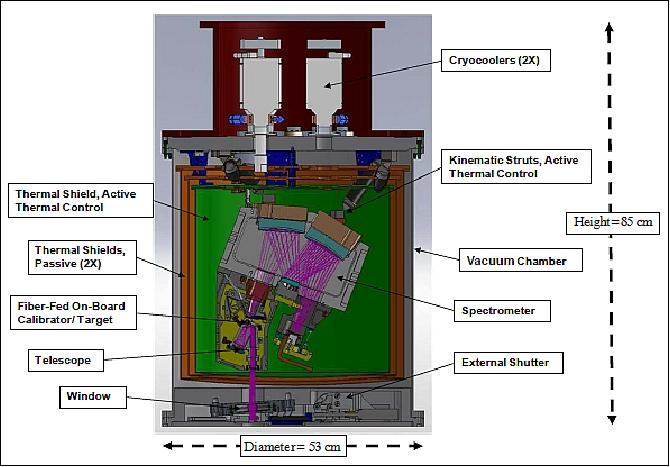
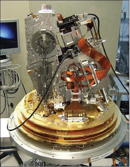
The instrument itself is ~85 cm tall and 53 cm in diameter. Major components include the optical telescope and spectrometer benches, the detector, the source for the OBC (On Board Calibrator) and kinematic struts which suspend the assembly from the instrument backplate. The sensor is housed with a vacuum container and three thermal shields and operated at temperatures of down to -40ºC at the detector. The maintenance of stable temperature across the instrument is vital to minimizing thermal distortions which could affect the optical alignment. The operational temperature is maintained by the operation of two cyrocoolers. This change to active cooling from the passive cryogen approach used for AVIRIS allows operation for up to 14 days at a time with only minimal maintenance of the vacuum.
AVIRIS-NG features new slit and grating technologies as well as new two-mirror all-reflective telescope.
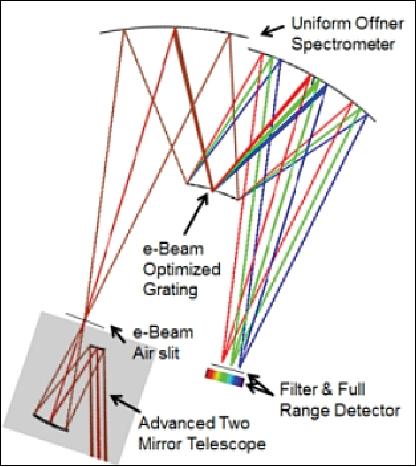
Optical | |
Spectral range | 380 - 2510 nm |
Spectral resolution (FWHM, minimum) | 5 nm ± 0.5 nm |
FOV (Field of View) | 36º ±2º with 600 resolved elements |
IFOV (Instantaneous Field of View) | 1.0-1.5 mrad ±0.1 mrad |
Spectral sampling (max observed at resolved elements) | 1.0 mrad ±0.1 mrad |
Spectral distortion (smile) | Uniformity > 97% |
Spectral distortion (keystone) | Uniformity > 97% |
Operations and environment | |
Operational real-time display | Waterfall display allows data quality check |
Self-sufficiency | Safe operation for 24 hours without maintenance or data download |
Ambient operating temperature | -40ºC to +50ºC |
Maximum altitude | 18 km |
Cool down time | < 48 hours |
Operational time / mission | 14 days |
Electronics | |
FPA (Focal Plane Array) | 480 (spectral direction) x 640 (cross-track) |
Frame rate | 10-100 frames/s |
Pixel size | 27 µm x 27 µm |
Calibration | OBC (On-Board Calibrator) |
Software | |
Headless operation | Autonomous fault protection responds to health and safety problems |
Data rate | Up to 74 MByte/s of throughput |
Data volume | Up to 1.0 Tbit of raw data before disk swap |
Mechanical | |
Volume of package | 87 cm (H) x 57 cm (diameter) plus electronics boxes and racks |
Total instrument mass | 465 kg |
Vacuum requirement | 10-4 Torr |
Data quantization | 14 bit |
Vibration environment | Maintain instrument calibration and operations when subjected to worst case aircraft random vibrational loads (defined for Twin Otter) |
Crash loads | 4.5 g side |
Mission Status
• December 8, 2017: A team of NASA scientists is using a high-altitude aircraft and a sophisticated imaging spectrometer built by NASA's Jet Propulsion Laboratory in Pasadena, California, to study environmental impacts caused by the devastating Southern California wildfires. NASA's ER-2, based at Armstrong Flight Research Center in Palmdale, California, flies as high as 21,300 m, almost twice as high as a commercial airliner. 3)
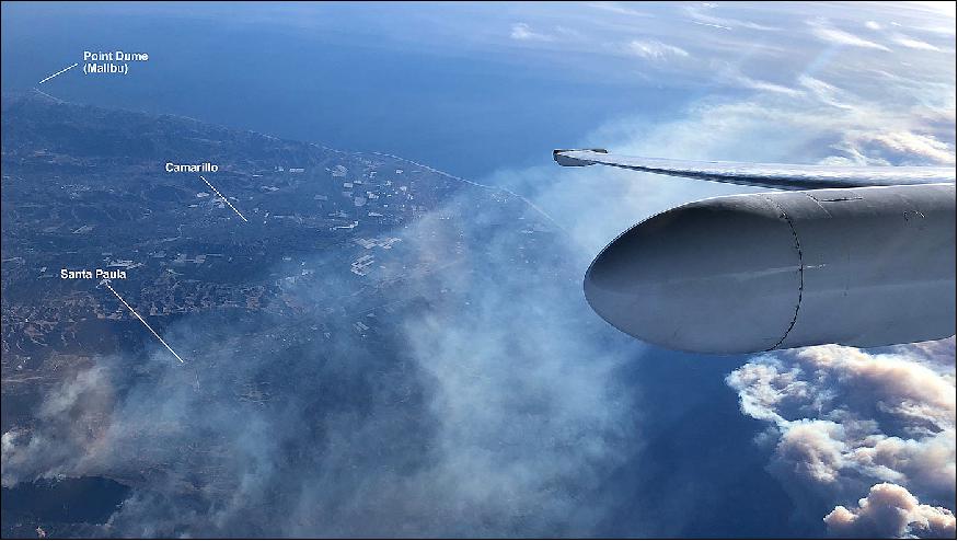
- NASA uses the unique perspective of the ER-2 for science research missions over much of the world. This month, the aircraft has been flying locally over California, testing early versions of science instruments that may one day be launched into space aboard a satellite to observe our home planet Earth.
- During these engineering test flights, the aircraft carried several science instruments aboard. One of them - a JPL spectrometer called AVIRIS - was in the right place at the right time when fires broke out in Los Angeles and Ventura Counties on Tuesday, December 4.
- AVIRIS (Airborne Visible/Infrared Imaging Spectrometer), is a modern instrument with an extensive heritage that can peer through smoke and dust to see information about the ground surface below. This includes observations of trees and other foliage that end up being fuel for wildfires.
- During a fire, the instrument can see aerosols, or particle matter, produced from the smoke, as well as the combustion process as fuel burns, and can accurately measure fire temperatures.
- AVIRIS can also observe fine details of vegetation, such as the water content in leaves and what types of species of plants are growing prior to a fire burning in a region. Scientists can use the instrument to fly over regions before a fire to get a base measurement of a certain area, fly over the same area again after a fire, and then compare the before-and-after images to determine the fire's severity.
- "The vision is that these types of measurements could be available from space in the next decade. The resulting information would then be used to develop fuel maps in advance that could be used to make better predictions about where you could mitigate risk by clearing brush and trees," said JPL's Rob Green, principal investigator of the AVIRIS instrument. Green continued, "Additionally, if a fire starts and authorities know exactly how much fuel is present in a region, the data will enable authorities to react quicker and provide a better assessment of how to approach extinguishing the fire and protect surrounding areas."
- NASA has funded this effort as part of its ongoing research, but is sharing the data with universities and government agencies like the U.S. Geological Survey, the University of California, and the University of Utah. Scientists at these organizations are working together to achieve a better understanding of response to fires, fire behavior, impacts to forest carbon dynamics, total area burned and smoke aerosols -- all of which have impacts to disaster preparedness, prevention, human health and safety.
AVIRIS-NG became operational in early 2013. It has been flying on both a Twin Otter aircraft and aboard the NASA ER-2 aircraft. It is available for use by NASA-approved scientists who wish to conduct ecological or mineralogical studies. One of the first flight campaigns of the 2013 season will be over-flying the site of the 2010 Deep Horizons Oil Spill off Texas and Louisiana in the United States. 4)
First flight: In April 2012, AVIRIS-NG — a new instrument developed to support NASA's Terrestrial Ecology Program and the planned HyspIRI mission — successfully completed its first flight onboard NASA's Twin Otter aircraft. 5) 6)
The first flight of AVIRIS-NG successfully demonstrated a thermal, actively cooled design that limits opto-thermal-mechanical distortions to less than 0.01% of a pixel. Another achievement of note, AVIRIS-NG demonstrated a new alignment methodology for optical instruments including the alignment of a HgCdTe focal plane at an ambient temperature (273 K).
References
1) L. Hamlin, R. O. Green, P. Mouroulis, M. Eastwood, D. Wilson, M. Dudik, C. Paine, "Imaging Spectrometer Science Measurements for Terrestrial Ecology: AVIRIS and New Developments," ESTF 2011 (Earth Science Technology Forum 2011), Pasadena, CA, USA, June 21-23, 2011, URL: http://esto.nasa.gov/conferences/estf2011/papers/Hamlin_ESTF2011.pdf
2) "Next Generation Airborne Visible/Infrared Imaging Spectrometer (AVIRISng)," NASA/JPL, URL: http://airbornescience.jpl.nasa.gov/instruments/avirisng/
3) "NASA Airborne Science Team Surveys California Fires," NASA/JPL, 8 Dec. 2017, URLhttps://www.jpl.nas: a.gov/news/news.php?feature=7020&utm
source=iContact&utm_medium=email&utm_campaign
NASAJPL&utm_content=daily20171208-1
4) Information provided by Louise Hamlin, Manager, JPL Next Generation Imaging Spectrometers (NextGen IS)
5) Jack A. Kaye, "Challenges And Successes In Creating Multi-instrument/Multi-platform Space-Based Earth System Data Records," July 31, 2012, URL: http://www1.ncdc.noaa.gov/pub/data/sds/cdr/presentations/other/kaye-2012.pdf
6) Andrea Martin, "Next Generation AVIRIS Instrument Completes Successful First Flight," NASA ESTO, May 2012, URL: https://web.archive.org/web/20170513075041/https://esto.nasa.gov/news/news_AVIRISng.html
7) "AVIRIS Next Generation First Spectra, " URL: http://aviris.jpl.nasa.gov/documents/pres_AVIRIS_NG_for_web_120430a_srl.pdf
The information compiled and edited in this article was provided by Herbert J. Kramer from his documentation of: "Observation of the Earth and Its Environment: Survey of Missions and Sensors" (Springer Verlag) as well as many other sources after the publication of the 4th edition in 2002. - Comments and corrections to this article are always welcome for further updates (eoportal@symbios.space).