Magnetic North Pole
Science
Magnetic North Pole Adjustment for 2019
Magnetic Model Tracking Changes Wandering of Geomagnetic Poles References
February 5, 2019: The position of the Earth's magnetic North Pole — used in navigation systems such as satellites and smartphones — is moving far faster than it has, sending scientists scrambling to put out a new model this week. 1)
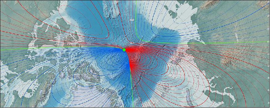
The magnetic North is the point at which the planet's magnetic field points vertically down. The World Magnetic Model is critical to sea and military navigation — as well as our ubiquitous smartphones. It normally is updated every five years but the schedule has been pushed forward one year "due to unplanned variations in the Arctic region," according to a statement from the US National Centers for Environmental Information.
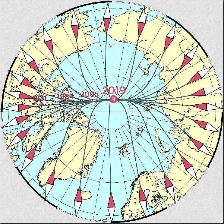
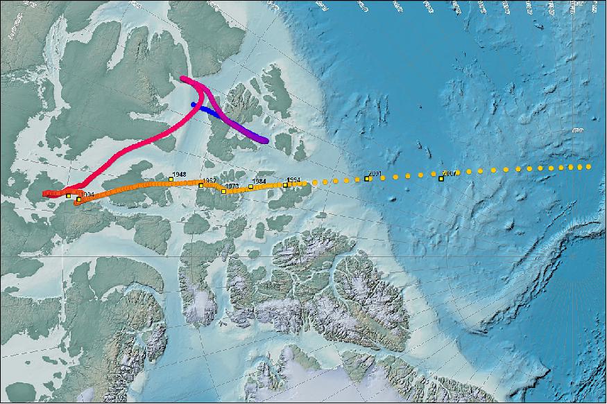
The discovery of magnetic north in northern Canada dates back to 1831. - The wandering point, which long jiggled above Canada and barely moved, is now moving 55 kilometers (34 miles) a year, scientists said.
The Earth's magnetic field is generated mainly by movement of the liquid iron that makes up most of the Earth's core, 3,000 km (2864 miles) below the surface. That movement is what makes the magnetic poles shift, but the cause of the recent acceleration remains a mystery.
So scientists at the American NOAA and Britain's BGS (British Geological Survey) have had to update their model ahead of the late 2019 scheduled deadline.
"It's a very slow movement, but it's very real, and over several decades it can be several degrees," said Arnaud Chulliat, geophysicist at the University of Colorado Boulder and NOAA. It does not matter much in the most populated areas, but "near the magnetic pole, the change is faster".
The model makes it possible to correct the direction indicated by the compass to find the geographic north, which is fixed.
Magnetic North has, over the centuries, moved more or less unpredictably into the archipelagos of northern Canada. Since the end of the 19th century, it has been heading toward Siberia.
Since the 1990s, the movement has accelerated, across the Arctic Ocean, from about 15 km/year to 50-55 km/year currently.
Swarm Helps Pinpoint New Magnetic North for Smartphones
February 8, 2019: Since it was first measured in 1831, we have known that the magnetic north is constantly on the move. However, its tendency to slowly roam has stepped up a pace recently – so much so that the World Magnetic Model has had to be updated urgently with the pole’s new location, vital for navigation on smartphones, for example. ESA’s magnetic field Swarm mission has been key for this update. 2)
The World Magnetic Model, the basis for many navigation systems used by ships, Google maps and smartphones, relies on the accurate knowledge of Earth’s magnetic field. Since magnetic north never stands still, the model has to be revised periodically – but a surge in pace has meant that an update was needed ahead of schedule.
Driven largely by the churning of fluid in Earth’s core, which generates the magnetic field, the magnetic north pole has always drifted, and geological evidence shows that every few hundred thousand years or so it even flips, so that north becomes south.
Around 50 years ago, the pole was ambling along at around 15 km a year, but now it is sprinting ahead at around 55 km a year. In 2017, it crossed the international date line, leaving the Canadian Arctic heading towards Siberia.
The World Magnetic Model is used to keep track of changes in the magnetic field and updated every five years by the US National Oceanic and Atmospheric Administration (NOAA) and the British Geological Survey (BGS).
The next update was due at the end of this year. However, thanks in part to ESA’s Swarm mission, researchers found that the pole is drifting in a way that wasn’t expected. This meant that model was simply too inaccurate for it to remain until the next planned revision. So, an ‘out-of-cycle’ update has just been issued.
Since the mission was launched in 2013, ESA’s Swarm constellation has been tracking variations in Earth’s magnetic field, and also the position of the magnetic north pole.
While measurements from Swarm are used to advance our scientific understanding of Earth’s magnetic field, they also have clear practical uses as demonstrated by their contribution to this urgent update of the World Magnetic Model, which is used every day by billions of people in their smartphones, even if they are unaware of it.
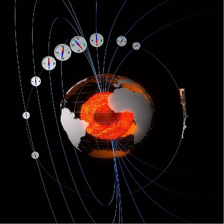
Nils Olsen from DTU Space(an institute at the Technical University of Denmark) said, “Your smartphone contains a magnetometer that measures Earth’s magnetic field. In order to make sense of this information, Android and iOS operating systems use the magnetic model to correct the measurements to true geographic north. So, in this model update, the latest Swarm data have been used to provide up-to-date information for users of numerous navigation systems.”

The World Magnetic Model
The World Magnetic Model (WMM) is a joint product of the United States’ National Geospatial-Intelligence Agency (NGA) and the United Kingdom’s Defence Geographic Centre (DGC). The WMM was developed jointly by the National Geophysical Data Center (NGDC, Boulder CO, USA) (now the National Centers for Environmental Information (NCEI)) and the British Geological Survey (BGS, Edinburgh, Scotland). 5)
The World Magnetic Model is the standard model used by the U.S. Department of Defense, the U.K. Ministry of Defence, the North Atlantic Treaty Organization (NATO) and the International Hydrographic Organization (IHO), for navigation, attitude and heading referencing systems using the geomagnetic field. It is also used widely in civilian navigation and heading systems. The model, associated software, and documentation are distributed by NCEI on behalf of NGA. The model is produced at 5-year intervals, with the current model expiring on December 31, 2019.
The full release of the out-of-cycle WMM (WMM2015v2) is now available. All WMM products and services have been updated. This new model addresses the degraded performance of WMM2015 in the Arctic region and supersedes it.
Earth’s northern magnetic pole is moving quickly away from the Canadian Arctic toward Siberia . This movement has forced NCEI’s scientists to update the World Magnetic Model (WMM) mid-cycle (Figure 4). 6)
Typically, a new and updated version of the WMM is released every five years. With the last release in 2015, the next version is scheduled for release at the end of 2019. Due to unplanned variations in the Arctic region, scientists have released a new model to more accurately represent the change of the magnetic field between 2015 and now.
This out-of-cycle update before next year’s official release of WMM2020 will ensure safe navigation for military applications, commercial airlines, search and rescue operations, and others operating around the North Pole.
Uses of the WMM: The military uses the WMM for undersea and aircraft navigation, parachute deployment, and more. Other governmental organizations, such as NASA, the FAA (Federal Aviation Administration), U.S. Forest Service, and many more use this technology for surveying and mapping, satellite/antenna tracking, and air traffic management.
Smartphone and consumer electronics companies also rely on the WMM to provide consumers with accurate compass apps, maps, and GPS services.
Airport runways are perhaps the most visible example of a navigation aid updated to match shifts in Earth’s magnetic field. Airports around the country use the data to give runways numerical names, which pilots refer to on the ground.
“The declination has changed just over 2.5 degrees over the past 22 years since Denver opened,” Heath Montgomery, the international airport’s former spokesperson, said after the last update.
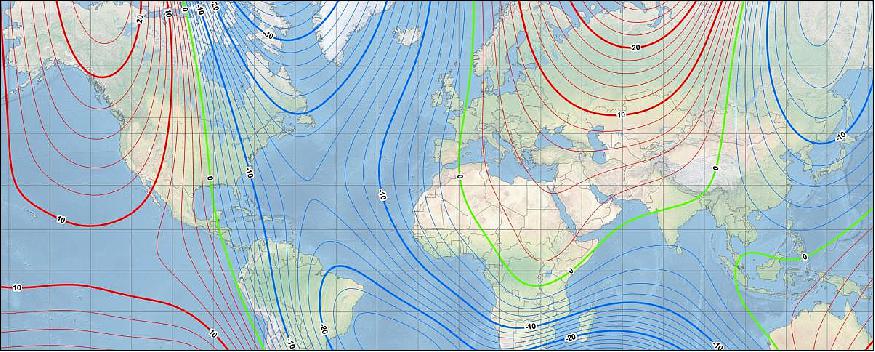
Legend to Figure 5: Compasses use declination (the difference between true north and where your compass points) to help correct navigation systems for a wide variety of uses. As Earth's magnetic field evolves between the 5-year release schedule of the WMM, these predicted values can become off as the rate of change in Earth's magnetic field evolves due to unpredictable flows in Earth’s core. The north polar region is experiencing one of these erratic changes.
Tracking Changes in the Earth’s Magnetic Poles
Earth's Magnetic History
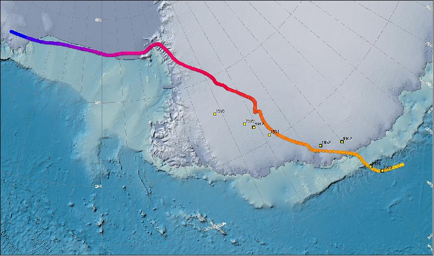
Sir James Clark Ross first discovered the North Magnetic Pole in northern Canada in 1831. Since 1831, the pole has been moving across the Canadian Arctic towards Russia. We’ve calculated the movement of both the North and South Magnetic Poles from 1590 to 2020 using two models: gufm1 and IGRF. Gufm1 incorporates thousands of magnetic observations taken by mariners engaged in merchant and naval shipping. The IGRF (International Geomagnetic Reference Field) is the product of a collaborative effort between magnetic field modelers and the institutes involved in collecting and disseminating magnetic field data from satellites and from observatories and surveys around the world. A recent survey by a Canadian–French international collaboration determined that the Pole is moving approximately north-northwest at 55 km per year.
Plates and Polarity: Synchronicity
Earth’s magnetic field has been slowly changing throughout its existence. When the tectonic plates form along the oceanic ridges, the magnetic field that exists is “frozen” into the rock as they cool below about 700°C. The slowly moving plates act as a kind of tape recorder leaving information about the strength and direction of past magnetic fields. By sampling these rocks and using radiometric dating techniques, it has been possible to reconstruct the history of the Earth's magnetic field for roughly the last 160 million years. If one “plays the tape backwards,” the record shows Earth’s magnetic field strengthening, weakening, and often changing polarity.
A recent survey by a Canadian–French international collaboration determined that the Pole is moving approximately north-northwest at 55 km per year.

Wandering of the Geomagnetic Poles
Geomagnetic poles: Magnetic poles are defined in different ways. They are commonly understood as positions on the Earth's surface where the geomagnetic field is vertical (i.e., perpendicular) to the ellipsoid. These north and south positions, called dip poles, do not need to be (and are not currently) antipodal. In principle the dip poles can be found by conducting a magnetic survey to determine where the field is vertical. Other definitions of geomagnetic poles depend on the way the poles are computed from a geomagnetic model. In practice the geomagnetic field is vertical on oval-shaped loci traced on a daily basis, with considerable variation from one day to the next. 8)
Experimental observations of dip poles: It has been long understood that dip poles migrate over time. In 1831, James Clark Ross located the north dip pole position in northern Canada. Natural Resources Canada (NRCan) tracked the North Magnetic Pole, which is slowly drifting across the Canadian Arctic, by periodically carrying out magnetic surveys to reestablish the Pole's location from 1948 to 1994. An international collaboration, led by a French fundraising association, Poly-Arctique, and involving NRCan, Institut de Physique du Globe de Paris and Bureau de Recherche Geologique et Miniere, added two locations of the North Magnetic Pole in 2001 and 2007. The most recent survey determined that the Pole is moving approximately north-northwest at 55 km per year.
A web based portal views both the experimental and modeled pole locations.
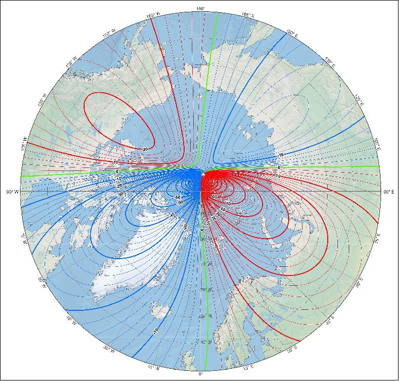
Movement of magnetic poles from 1590 to 2020: The magnetic poles or dip pole are computed from all the Gauss coefficients using an iterative method. Magnetic poles derived in this fashion are geographically closer to the experimentally observed poles. Based on the current WMM2015v2 model, the 2019 location of the north magnetic pole is 86.54°N and 170.88°E and the south magnetic pole is 64.13°S and 136.02°E.
The locations of the poles (2015-2020) derived from WMM2015v2 are available here: North Pole, South Pole.
The locations of the poles (1590-2020) derived from gUFM and IGRF models are available for download here: North Pole, South Pole.
References
1) ”Magnetic north pole leaves Canada, on fast new path,” GPS Daily, 5 February, 2019, URL: http://www.gpsdaily.com/reports
/Magnetic_north_pole_leaves_Canada_on_fast_new_path_999.html
2) ”Swarm helps pinpoint new magnetic north for smartphones,” ESA, 8 February 2019, URL: http://m.esa.int/Our_Activities/Observing_the_Earth/Swarm
/Swarm_helps_pinpoint_new_magnetic_north_for_smartphones
3) Magnetic north on the move,” DTU Space, 8 February 2019, URL: http://m.esa.int/spaceinimages/Images/2019/02/Magnetic_north_on_the_move
4) ”Swarm compasses,” ESA, 28 October 2013, URL: http://m.esa.int/spaceinimages/Images/2013/10/Swarm_compasses
5) ”The World Magnetic Model,” NCEI (National Centers for Environmental Information), 4 February, 2019, URL: https://www.ngdc.noaa.gov/geomag/WMM/
6) ”World Magnetic Model Out-of-Cycle Release,” NOAA, NCEI, 4 February 2019, URL: https://www.ncei.noaa.gov/news/world-magnetic-model-out-cycle-release
7) ”Tracking Changes in Earth’s Magnetic Poles,” NOAA, NCEI, 28 March 2016, URL: https://www.ncei.noaa.gov/news/tracking-changes-earth-magnetic-poles
8) ”Wandering of the Geomagnetic poles,” NOAA, NCEI, URL: https://www.ngdc.noaa.gov/geomag/GeomagneticPoles.shtml
The information compiled and edited in this article was provided by Herbert J. Kramer from his documentation of: ”Observation of the Earth and Its Environment: Survey of Missions and Sensors” (Springer Verlag) as well as many other sources after the publication of the 4th edition in 2002. - Comments and corrections to this article are always welcome for further updates (eoportal@symbios.space).
Magnetic Model Tracking Changes Wandering of Geomagnetic Poles References Back to top