TIMS (Tropospheric Infrared Mapping Spectrometers)
Airborne Sensors
TIMS (Tropospheric Infrared Mapping Spectrometers)
TIMS is an instrument technology demonstration project within IIP (Instrument Incubator Program) of NASA. The overall objectives are the need for improved atmospheric measurements to gain crucial understanding for air quality, climate change, and weather. In particular, improved vertical and horizontal resolution, temporal resolution and coverage are required. 1) 2)
The goals of TIMS are focused on providing considerably improved measurements of CO, commensurate with the requirements of the “decadal survey” report of NRC in January 2007. In recommending a Global Atmospheric Composition Mission (GACM), and a Geostationary Coastal and Air Pollution Events Mission (GEO-CAPE), the report notes that: “Current observation systems for air quality are inadequate to monitor population exposure and develop effective emission control strategies.” The report calls for the measurement of O3 and its precursors, and key trace gases including CO and HCHO, and places high priority on:
• Sufficient vertical resolution to detect the presence, transport, and chemical transformation of atmospheric layers from surface to the stratosphere, and
• High spatial and temporal resolution in order to track emissions of ozone and aerosol precursors; pollutant transport into, across, and out of North, Central, and South America; and to detect large puff releases from environmental disasters.
The primary measurement goal of TIMS is CO retrieval, but the spectra contain information that facilitates retrieval of column CH4, and H2O partial columns (vertical information), including considerable improvement in the boundary layer (BL).
TIMS Instrument
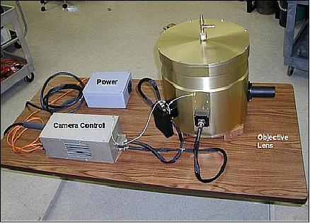
The prototype instrument has been designed and developed for NASA by LMATC (Lockheed Martin Advanced Technology Center) of Palo Alto, CA. The completed modules have been deployed in two groundbased atmospheric measurement campaigns at the University of Denver (DU).
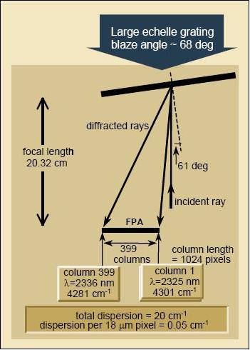
TIMS comprises two separate high spectral resolution grating spectrometer modules, operating respectively in the CO MWIR (Midwave Infrared) band near 4.68 µm (~2137 cm -1), and the CO SWIR (Short Wave Infrared) band near 2.33 µm (~4292 cm-1). 3) 4)
Spectral Region | Spectral Range | Spectral Resolution | Targeted Species |
MWIR | 2112–2160 cm-1 | 0.5 cm -1 | CO, H2O |
SWIR | 4281–4301 cm-1 | 0.2 cm-1 | CO, H2O |
Spectral region | Aperture | FOV along slit | IFOV (pixel) |
MWIR | 3.9 cm | 10.4º | 0.18 mrad |
SWIR | 3.5 cm | 10.4º | 0.18 mrad |
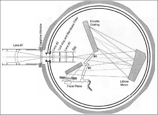
Both modules use the “solid state” spectrometer technique in which a fixed grating is coupled with a HgCdTe detector array of size 1024 x 1024 pixels with 18.5 µm pixels, providing spectral content along one direction, and spatial content across the other. This eliminates the need for any form of spectral scanning mechanism or time sharing of spectral intervals. It enables smaller, lighter, instruments and a less complex, rugged, and stable opto-mechanical design, particularly well suited to the launch environment and long-term reliability on orbit.
MWIR Spectrometer Module of TIMS
The MWIR module features a reflective Littrow configuration. It has an aperture diameter of 3.9 cm, a FOV of 10.4º in the along slit direction, and an IFOV of 0.18 mrad.
TIMS Observation Concept
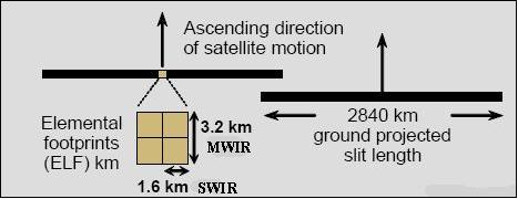
For a LEO mission, the instrument operates in a nadir-looking configuration with field of view (FOV) coverage (Figure 3). The anamorphic field widening front end optics provide a swath of ± 57º which is equivalent to a cross-track projection of 2840 km with a corresponding footprint of ~ 1.6 km at nadir along the swath in the SR (Solar Reflective) region of CO absorption near 2.33 µm of SWIR (Shortwave Infrared), and a 3.2 km footprint in the MWIR (Midwave Infrared) SR region of CO absorption near 4.68 µm.
Data are acquired in a wide pushbroom swath of contiguous footprints with swaths wide enough to allow the ends to overlap for both ascending, and descending nodes for a sun synchronous polar orbiting case. This provides twice daily global coverage for the MWIR CO band, and once daily for the SR CO band.
For the case of a geostationary orbit, coverage is achieved by a scan mirror that pushbrooms the slit across the disk. subsatellite point diffraction limited footprints of 1.6 and 3.2 km in the SWIR and MWIR, respectively, can be achieved with a 13.6 cm aperture, and the slit would project along a 1640 km swath width (Table 1). With these measurements the space deployed TIMS retrieval expectations are:
- CO in the boundary layer (BL) and two layers above on the order of 10 and 5 with respective precisions of 3 %.
- H2O retrieval in the BL and more than 2 layers above
- CH4 column retrieval
- some tropospheric O3 information.
On Sept. 29, 2010, LMATC flight-tested the TIMS shortwave instrument in a dirigible to assess signal-to-noise with a realistic geometry. 5)
TIMS Accomplishments
• Developed SWIR and MWIR portable brassboard spectrometers with required spectral resolution and sensitivity; achieved: 6)
- Noise equivalent delta radiance NEΔR = 2.74 x 10⁻¹⁰ & 1.28 x 10⁻¹⁰ W/(cm2 sr cm-1) for SWIR & MWIR, respectively, better than threshold values 8 x 10⁻¹⁰ & 2 x 10⁻¹⁰ as stated in the original proposal
- Spectral resolution of 0.25 and 0.53 cm-1 as compared to goals 0.13 and 0.2 cm-1; however, these actuals are far better than those achieved by previous spectrometers such as SCIAMACHY or AIRS, and coupled with the low noise have facilitated excellent CO retrievals.
• Demonstrated their ability to acquire high quality atmospheric spectra in ground-based tests
• Validated retrieval of CO profiles from these spectra through comparison with Denver University FTS measurements
• The measurement concept has been demonstrated through ground measurements campaigns and ongoing dirigible flight tests for 2.3 µm
• Developed concepts for flight instrument design, operation, and data production – focus has been on the GEO-CAPE mission
• Analysis of 2.3 and 4.6 µm instrument performance confirmed Geo-CAPE-capable sensing of CO, CH4, and O3, NH3, (latter with 9.6 µm).
References
1) John B. Kumer, A. E. Roche, R. L. Rairden, J. L. Mergenthaler, R. B. Chatfield, “Tropospheric Infrared Mapping Spectrometers (TIMS) for CO Measurements With Much Improved Vertical, Temporal and Spatial Resolution, Especially in the Lower Troposphere by Utilizing Both the 2.3 and 4.7 µm Regions,” NSTC2007 (NASA Science and Technology Conference 2007), June 19-20, 2007, College Park, MD, USA, URL: http://esto.nasa.gov/conferences/nstc2007/papers/Kumer_John_(Jack)_B6P1_NSTC-07-0056.pdf
2) J. B. Kumer, A. E. Roche, R. L. Rairden, J. L. Mergenthaler, R. B. Chatfield, R. D. Blatherwick, T. Hawat, “Tropospheric Infrared Mapping Spectrometers (TIMS) for CO Measurements With Much Improved Vertical, Temporal and Spatial Resolution in the Lower Troposphere by Utilizing Both the 2.3 and 4.7 µm Regions,” ESTC2008 (Earth Science Technology Conference 2008), June 24-26, 2008, College Park, MD, USA, URL: http://esto.nasa.gov/conferences/estc2008/papers/Roche_Aidan_B3P3.pdf
3) J. B. Kumer, J. Mergenthaler, A.E. Roche, R Rairden, Robert Chatfield, “Tropospheric infrared mapping spectrometers (TIMS) for Air Quality measurements,” URL: http://www.acd.ucar.edu/.../4.P.Kumer.pdf
4) J. B. Kumer, A. E. Roche, R. L. Rairden, J. L. Mergenthaler, J. H. Doolittle, R. D. Blatherwick, T. Hawat, R. B. Chatfield, “Tropospheric Infrared Mapping Spectrometers (TIMS) to provide measurements with much improved vertical, temporal and spatial resolution in the lower troposphere,” Proceedings of IGARSS 2008 (IEEE International Geoscience & Remote Sensing Symposium), Boston, MA, USA, July 6-11, 2008
5) John B. Kumer, Richard Rairden, Aidan Roche, Robert Chatfield , “NASA ESTO IIP Tropospheric Infrared Mapping Spectrometers (TIMS) demonstration first deployment on an airship: Preliminary results,” Conference paperHtuD2:: Hyperspectral Imaging and Sounding of the Environment, OSA, (Optical Society of America), Technical Digest, Toronto, Canada, July 10, 2011
6) John Kumer, “Tropospheric Infrared Mapping Spectrometer (TIMS) for CO,” presented in: 'Overview of Relevant Instrument Technologies supported by the NASA Instrument Incubator Program,' GEO-CAPE Community Workshop, ESTO (Earth Science Technology Office), Karen Moe, May 11, 2011, URL: http://geo-cape.larc.nasa.gov/2011May-GEOCAPE/02aWednesdayAfternoon_GEOCAPE/Moe_Technology.ppt
The information compiled and edited in this article was provided by Herbert J. Kramer from his documentation of: ”Observation of the Earth and Its Environment: Survey of Missions and Sensors” (Springer Verlag) as well as many other sources after the publication of the 4th edition in 2002. - Comments and corrections to this article are always welcome for further updates (eoportal@symbios.space).