Vanilla UAS (Unmanned Aircraft System)
Airborne Sensors
Vanilla UAS (Unmanned Aircraft System) for Arctic Operations
Vanilla Unmanned is the world-record holding Group 3 Ultra-Long Endurance UAS (ULE UAS) capable of multi-day flights with unmatched payload capacity. Vanilla Unmanned is owned and operated by Platform Aerospace, Hollywood, MD,, USA. 1)
February 2022: They've delivered groceries and performed light shows at the Olympics. But in the unforgiving Arctic climate, drones have struggled to fly for extended periods of time — the kind that would allow researchers to fly scientific instruments safely to keep tabs on the region. — Now, a team led by NASA scientists is showing how a fixed-winged drone named Vanilla could fly for several days over the Arctic ocean carrying an instrument that uses radar to measure the depth of snow accumulating on top of sea ice. 2)
By testing the drone and snow radar instrument together, the team wants to provide key data to more accurately track and project how Earth's polar regions are changing and influencing sea level.
Because snowfall puts an additional layer of snow over sea ice, even some of NASA's most powerful altimeter systems in space struggle to measure the thickness of the ice. Data from drones flying at low altitudes can help scientists measure this changing thickness more accurately as Arctic sea ice waxes and wanes with the seasons.
"The same technique could eventually be used to assess how freshwater melting from Greenland and Antarctica contributes to sea level rise," says Brooke Medley, a research scientist at NASA's Goddard Space Flight Center in Greenbelt, Maryland, who leads the project.
In other words, Medley sees in drones, a path toward increasingly accurate projections of how sea level rise might reshape coastlines worldwide, and, for more temperate climates, a promising new tool to monitor wildfires, algal blooms, and other vital signals of change on Earth.
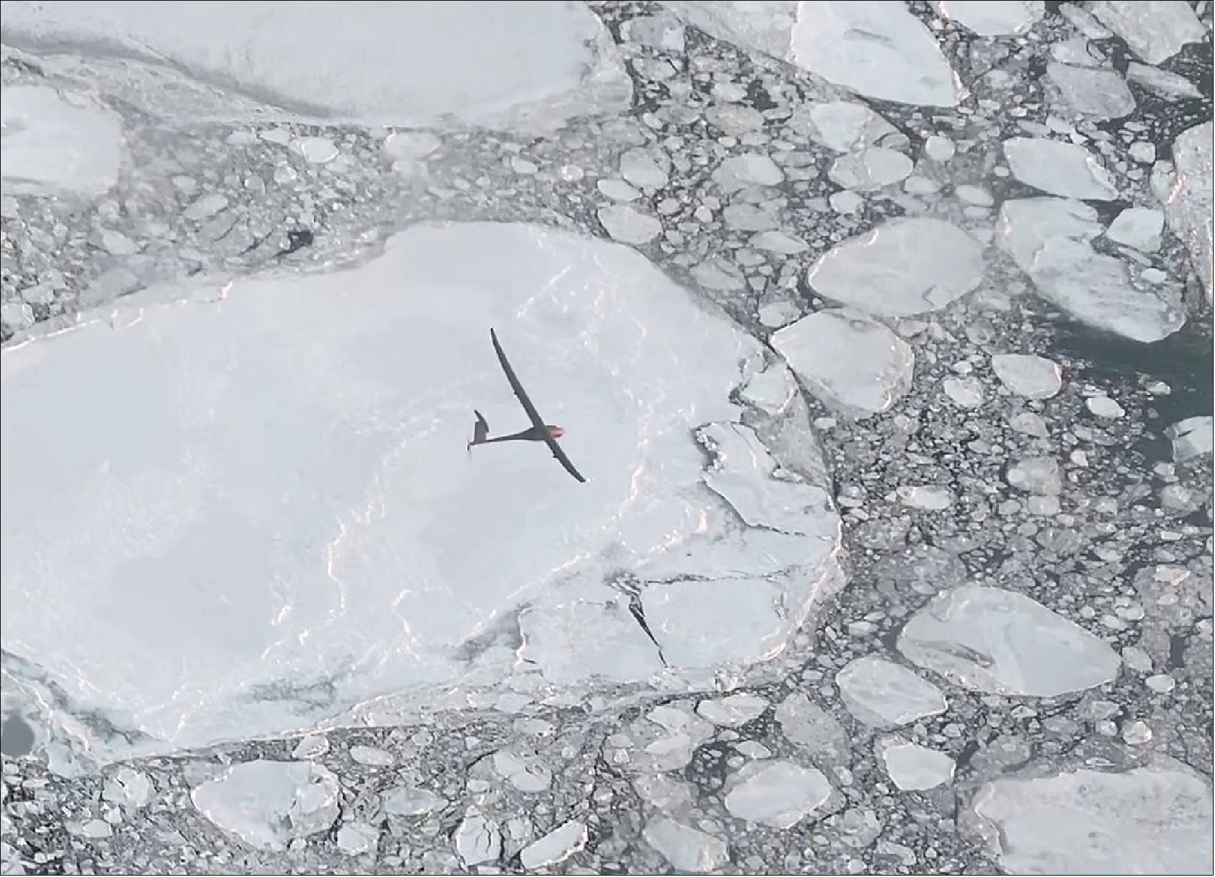
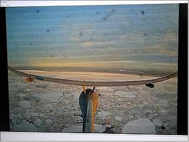
In November 2021, Vanilla flew for six hours over open ocean and sea ice more than 130 miles (222 km) from an airport in Deadhorse, Alaska, where a pilot controlled the aircraft and a scientist controlled the radar instrument.
By flying in more temperate weather for eight days straight in 2021, Vanilla earned the world record for continuous flight without refueling by a remotely piloted aircraft with internal combustion engine. In Alaska, unusual precipitation prevented multi-day flights, but early assessments show Vanilla could fly for nearly five days over Arctic sea ice.
To earn its "Arctic wings," Vanilla flew with ice-detecting sensors, heating systems, and a special anti-icing coating to protect against fog and moisture that can quickly ice on its wings and propeller. The aircraft also runs on a diesel engine, which helps to regulate heat unlike battery-operated drones.
"Drones have come a long way, enough that they can start to be more than just quadcopters flying locally and looking at your neighborhood," Medley says. "Flying drones is ultimately more green and safer than flying large planes, so this checks a lot of boxes."
Medley, who leads the project, wants to survey sea ice in the Arctic and Southern Ocean with the drone. Ultimately, the idea is to fly over Greenland and Antarctica, Earth's two ice sheets. Unlike expensive and labor-intensive airborne campaigns that rely on airplanes and crew, multiple drones could fly simultaneously, on a regular basis, and in multi-day surveys of an entire ice sheet, Medley says.
NASA satellites have played a key role in detecting how ice sheets have lost mass in recent decades. But they have struggled to measure fine details about how variations in snow depth on the surface of the ice affect the thickness of these continental glaciers.
Scientists typically determine the health of an ice sheet by measuring changes in surface height that help assess whether the ice is thinning or thickening. But snow blows constantly all around an ice sheet and piles on its surface over several years like a multilayer cake that satellites struggle to track.
"We have to make sure the thickness changes we're seeing aren't just a single snowfall event or the lack of a single snowfall event," Medley says. "Then we can better interpret the changes that we're seeing from space if we know how much snow is falling."
Because sea ice is already floating on the ocean, sea level does not rise significantly when that ice melts. But snowfall that settles on the ice sheets eventually melts and deposits freshwater into the ocean. Stored as frozen water on the surface of an ice sheet, this snow can also stall an ice sheet's contribution to sea level rise, Medley says.
How exactly that accumulated snow influences sea levels is a poorly understood processes in studies of sea level rise.
"We need to monitor this snow accumulation," Medley says, "because small changes can actually end up playing a very large role in sea level change."
About the Aircraft
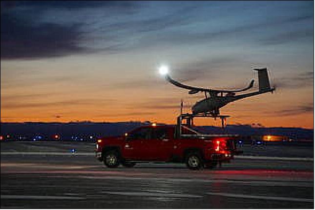
Vanilla Unmanned fills an unmet requirement for multi-day surveillance and inspection operations at an attributable – or cost-effective – price point. Vanilla has demonstrated world-record endurance, and is capable of multi-mission beyond visual line of sight (BVLOS) operations providing days of time-on-target or thousands of miles of search capacity on a single flight. 3)
No other system provides the endurance, payload capacity, and cost-profile of Vanilla Unmanned.
About Platform Aerospace
Platform Aerospace is a service-disabled veteran-owned small business (SDVOSB) dedicated to supporting the warfighter and its customers' success. Platform is AS9100D and ISO 9001:2015 certified, and specializes in manufacturing, aviation modification and prototyping, and cutting-edge aerial ISR (Intelligence Surveillance and Reconnaissance) products.
Vanilla UAS Arctic Operations: From the Desert to the Frozen North (Ref. 1)
Flying from Deadhorse on Alaska's Northern Slope, Vanilla Unmanned conducted Arctic environmental monitoring operations on behalf of the NASA Goddard Cryospheric Sciences Laboratory and the University of Kansas (KU) Center for Remote Sensing of Ice Sheets (CReSIS).
The sortie represents yet another Vanilla-only multi-payload, over the horizon (beyond visual line of sight, BVLOS) capability and comes immediately on the heels of Vanilla's >8-day world record flight in the California desert.
Operating in the Arctic Circle at 72 degrees north of the equator in temperatures ranging from 0° to 15°F, NASA declared the mission a success after the aircraft demonstrated its ability to gather snow and ice thickness data using wing-mounted radar, and to operate on SATCOM in the harsh Arctic environment.
Vanilla carried as payloads KU's RADAR for snow depth measurements, a SKYTRAC SATCOM radio for high-latitude operations, and multiple state-of-the-art ice detection and anti-icing applications, along with modifications for the cold temperatures.
"The extreme weather conditions were challenging," said Dr. Dan Edwards, Platform Aerospace's Chief Technology Officer. "But pre-flight ground runs showed that Vanilla's anti-icing and weather hardening modifications were sufficient to fly in these austere conditions. Flying at 2,000 feet altitude at 130 miles range over the Arctic Ocean with KU's Radar and all on SATCOM, this was a high-risk, high-reward flight. Vanilla now has its Arctic wings."
This polar operation illustrates a broader market shift to replace traditionally manned surveying operations with lower-risk, long-endurance UAS that offer greater data collection at reduced cost.
"We are grateful for the partnerships with NASA Goddard, the University of Kansas, Alaska Center for Unmanned Aircraft Systems Integration, Alaska DOT, and other stakeholders who worked together to navigate first-of-their-kind airspace and operational challenges," said Jared Tharp, Chief Operations Officer. "Delivering the mission success from a remote location was a great demonstration of the Platform team's capabilities."
Vanilla Smashes World Record: >8 days, >12,000 Miles, Comms Package
Vanilla Unmanned demonstrated 8 days, 50 minutes, and 47 seconds of continuous flight, breaking the world record for unrefueled, internal combustion endurance of an unmanned aircraft. 4)
Vanilla launched from Rogers Dry Lakebed on Friday, September 24th and was recovered on Saturday, October 2nd having flown 12,200 miles over Edwards Air Force Base with a communications relay system & ample ballast to accommodate other sensors.
The 8 day flight is a step change from Vanilla's prior record of 5 days and is without comparison to other UAS. The flight was conducted in coordination with Edwards Air Force Base and has been submitted for ratification as an official world record.
The world-record flight was the last in a series of events at Edwards Air Force Base demonstrating Vanilla's unique multi-day, multi-sensor capability. Several sorties over 50 hours each carried two EO/IR cameras, two satellite communications systems for BVLOS operations, and a customer-proprietary radar in addition to the mesh radio system.
"Vanilla has changed the definition of endurance. This is a tactical asset with strategic relevance," says Dr. Dan Edwards, Platform Aerospace CTO. "The notion that tactical UAS must be VTOL and fly for less than 24 hours excludes a disruptive technology that could be fielded today. The value of inexpensive multi-day, multi-sensor coverage is immense."
Unlike larger long endurance UAS, Vanilla is a tactical-scale Group III system that uses an internal-combustion engine for propulsion. Its smaller size enables runway independent launch from forward locations with minimal manning. Unlike solar-powered high-altitude systems, Vanilla is immediately responsive to operator tasking and flies at tactical altitudes, thereby accommodating smaller and lower cost sensors for the same C5ISR value. Vanilla runs on standard Jet-A fuel, easing logistics concerns during forward operations.
Vanilla's airframe can carry up to 150 lbs of sensor payloads across five internal bays and external mounts, each receiving onboard power and datalink for sensor C2. A VTOL variant is in production with government sponsorship and will take flight in early 2022.
Platform Aerospace would like to acknowledge its employees, industry partners, and government sponsors whose engagement was instrumental in achieving this aviation milestone. Government sponsors include: USAF's 412th Test Wing's Emerging Technologies Combined Test Force (ET-CTF), the Office of Naval Research (ONR), Naval Air Systems Command (NAVAIR), and NASA among others. Industry partners include: AlarisPro, IMSAR, Inmarsat Government, L3Harris WESCAM, Mission Secure, Inc., Progeny, Sechan Electronics, and VX Aerospace. Record submission is through the Academy of Model Aeronautics.
References
1) Vanilla UAS Arctic Operations: From the Desert to the Frozen North, Vanilla Unmanned, 2021, URL: https://vanillaunmanned.com/news/vanilla-uas-arctic-operations
2) Roberto Molar Candanosa, "NASA is Helping Fly Drones in the Arctic. Here's What That Means for Sea Ice and Sea Level Change," NASA Feature, 24 February 2022, URL: https://www.nasa.gov/feature/goddard/2022/nasa-helps-fly-drone-in-alaska-to-study-sea-ice-thickness
3) "Vanilla Datasheet," URL: https://vanillaunmanned.com/
4) "Vanilla Smashes World Record: >8 days, >12,000 miles, Comms Package," Vanilla Unmanned, 2 October 2021, URL: https://vanillaunmanned.com/news/
vanilla-smashes-world-record-8-days-12000-miles-comms-package
The information compiled and edited in this article was provided by Herbert J. Kramer from his documentation of: "Observation of the Earth and Its Environment: Survey of Missions and Sensors" (Springer Verlag) as well as many other sources after the publication of the 4th edition in 2002. - Comments and corrections to this article are always welcome for further updates (eoportal@symbios.space).