Wetland Observations
Applications
Wetland Observations — 50 Years of Ramsar Convention of Wetlands
Space, Key to Wetland Conservation Water Resource Management
World Wetlands Day Focuses on Agriculture
Monitoring Wetlands for Sustainable Water Management References
Celebrated annually on 2 February, World Wetlands Day aims to raise global awareness about the importance of wetlands for our planet. This year’s theme shines a light on wetlands as a source of freshwater and encourages actions to restore them. From their vantage point of 800 km high, Earth-observing satellites provide data and imagery on wetlands that can be used to monitor and manage these precious resources sustainably. 1)
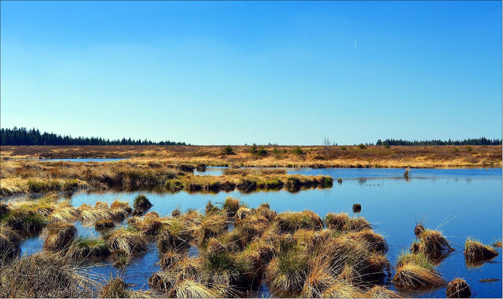
Natural wetlands are some of the most diverse and productive ecosystems and are critical for human survival. They provide many important benefits for humanity, ranging from freshwater supply, providing food and habitat, supporting biodiversity, to flood control, improving water quality and climate change mitigation.
Yet wetlands face many challenges. According to the Ramsar Convention, 64% of the world’s wetlands have disappeared since the beginning of the last century. Some wetlands have been lost or degraded as a result of pollution, overexploitation of resources and deforestation.
On 2 February 1971, 50 years ago today, the Convention on Wetlands of International Importance was signed in Ramsar, Iran. All bodies involved in implementing the convention require up-to-date data and reliable information to better understand wetland areas, complete national inventories, perform monitoring activities, carry out assessments and put appropriate management plans in practice.
Earth observation is recognized as a reliable and cost-effective technique for analyzing and quantifying various aspects of wetland waters. The monitoring of inland water bodies is essential in order to characterize water bodies, identify changes or trends in water quantity and quality, and assess how these changes impact the integrity of wetland ecosystems and the services they provide.
For example, the Ogooué River in Gabon, the fourth largest river in Africa by volume of discharge and catchment, is home to important wetlands. However, the river is largely unmonitored, and the lack of observations poses a significant challenge to management efforts.
Earth observation can help bridge this gap, providing highly valuable observations to monitor the changes in river flows and their incidence on the water regimes of downstream wetlands.
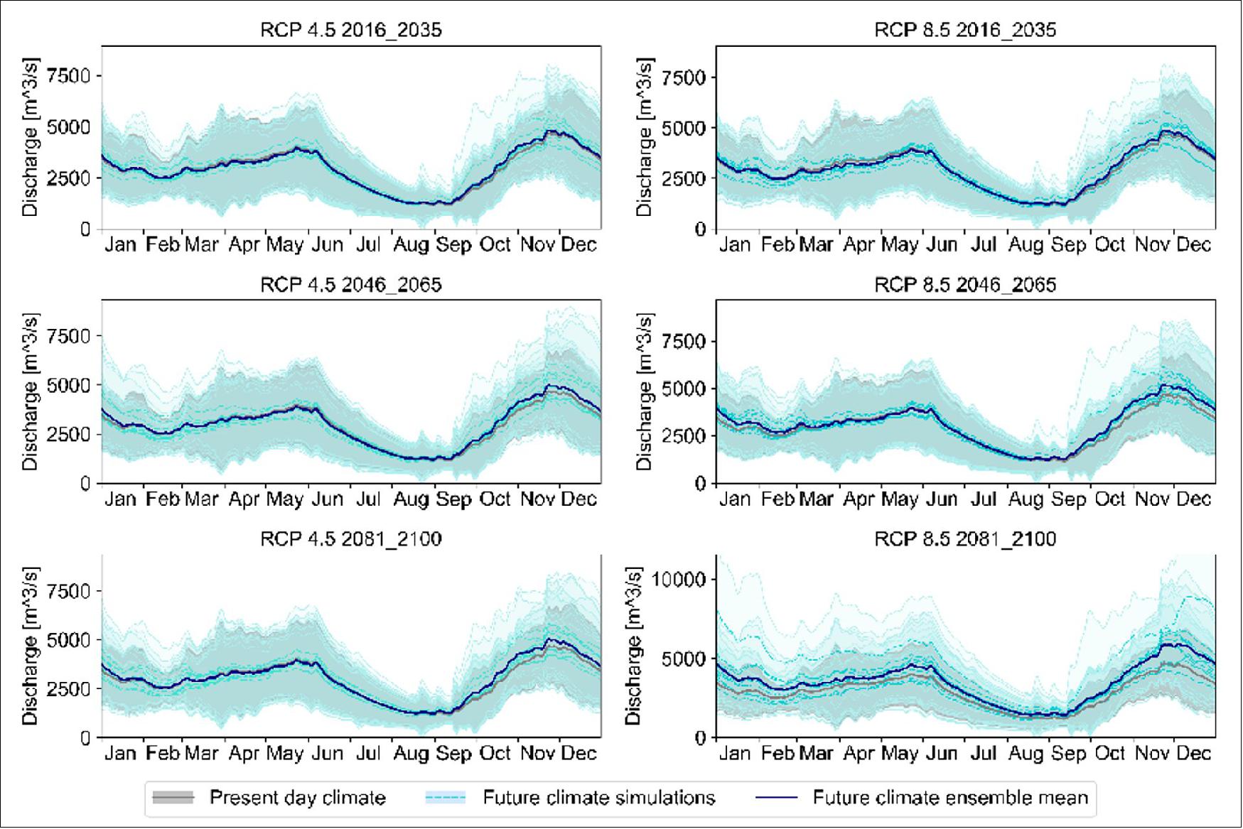
ESA’s GlobWetland Africa project has demonstrated how data from both ESA’s CryoSat-2 mission and from the Synthetic Aperture Radar Altimeter (SIRAL) instrument onboard the Copernicus Sentinel-3 mission can be assimilated in hydrological simulation models to assess the river’s water balance and analyze changes in the inflow hydrographs to selected wetlands in response to land use changes, hydropower and climate change.
Hydrographs show the rate of flow, or discharge, over time. These models are key in understanding catchment dynamics and are an essential tool to systematically evaluate the interactions between water availability, water use sectors and future climate.
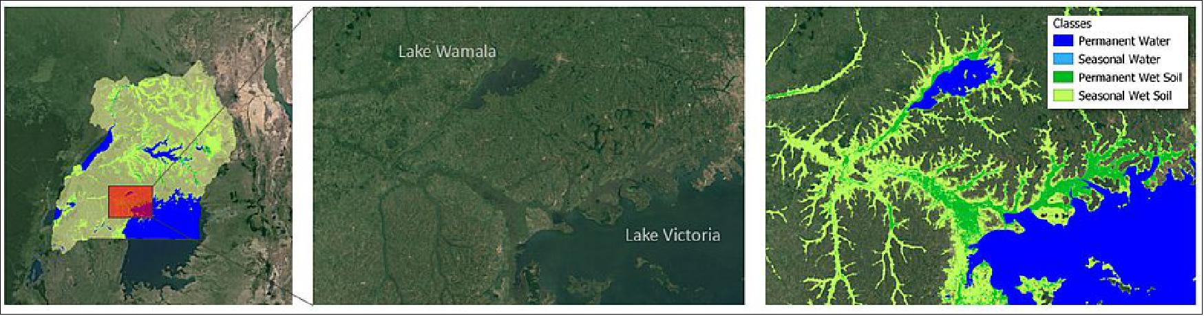
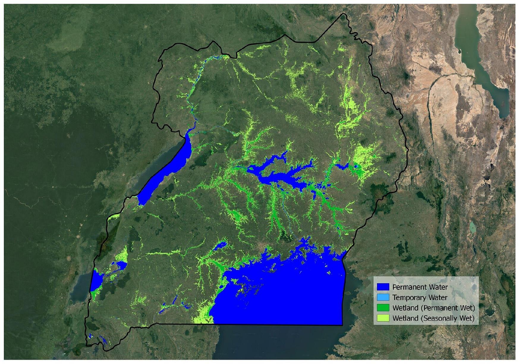
In Uganda, wetlands and other water bodies cover roughly 10% of the country’s surface, and is home to Africa’s largest lake, Lake Victoria. However, many wetlands are put under pressure from drainage and are reclaimed to provide land for local communities to increase agriculture production for the rapidly growing population.
In order to map the dynamics of the water bodies and wetlands, ESA’s GlobWetland Africa project team used four years of data from the Copernicus Sentinel-1 and Sentinel-2 missions merged together in a hybrid approach to map the extent and frequencies of water and moist soils, and used as input for preparing national wetland inventories.
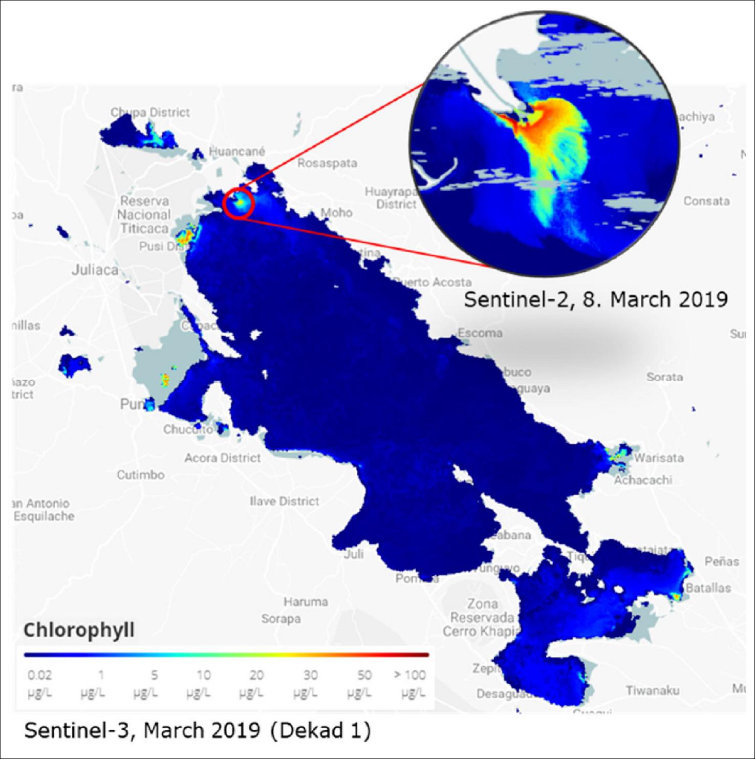
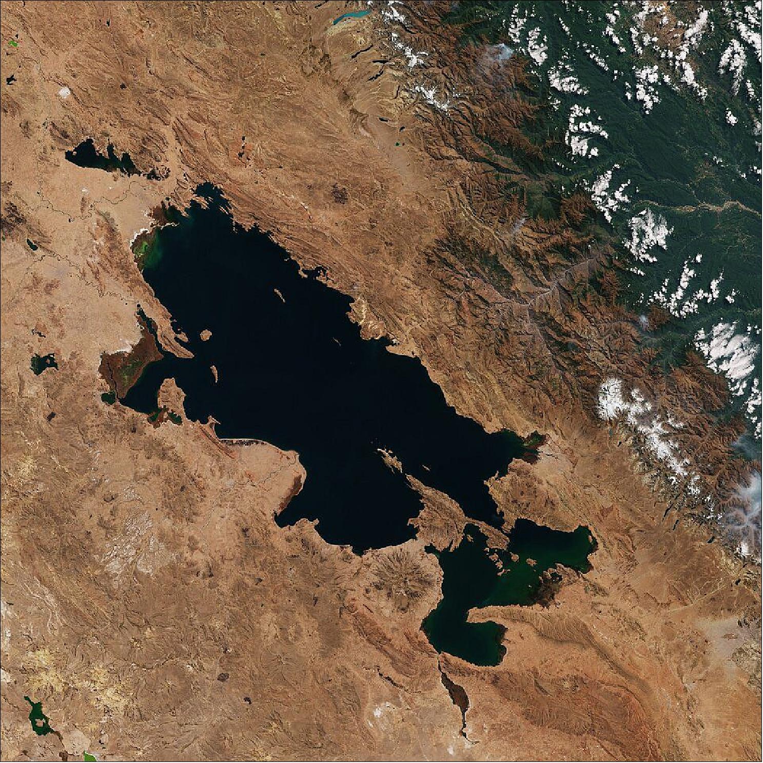
Under ESA’s Earth Observation for Sustainable Development (EO4SD) initiative, data from the Copernicus Sentinel-3 mission was used to analyze water quality in Lake Titicaca – the second largest lake in South America and a designated Ramsar site. The unique and fragile ecosystem is negatively impacted by environmental degradation, caused by natural and anthropogenic causes, including sediment runoff and soil sanitisation, untreated urban and mining effluents and unstainable agriculture, fishing and aquaculture practices.
Sentinel-3 has been used to monitor the variation of suspended matter and chlorophyll concentrations in the lake thereby helping to detect trends and hot spots over time, information which is required to make timely decisions to emerging water quality problems, such as the identification of sediment plumes, harmful algae blooms and red tides.
Christian Tottrup, DHI GRAS and project leader of EO4SD on water resource management, commented, “Earth observation is a cost-effective technology for identifying the specific time, place and concentration of pollution – information which is of utmost importance to monitor large investment projects on sanitation infrastructure around the lake.”
The contribution of Earth observation was also valued on the ground. Rene Quispe Chambi, a specialist in water resource management from the National Water Authority (Autoridad Nacional de Agua or ANA) in Peru, said, “It is our objective to integrate Earth observation data into our water monitoring systems as decision makers require this type of information.”
ESA’s Marc Paganini added, “The European Copernicus program and its Sentinels offer unprecedented opportunities for the Ramsar Contracting Parties to conduct the necessary wetland inventory, monitoring and assessment that ensure the wise use and conservation of their wetlands, which is the primary aim of the Ramsar Convention.
“The open and free data policy of the Sentinels along with their global coverage and the assurance of long-term continuity of observations, are important incentives for wetland practitioners to routinely integrate Earth observation in their work.”
Space, Key to Wetland Conservation
February 5, 2020: Wetlands worldwide are vanishing at an alarming rate. New maps produced by ESA’s GlobWetland Africa project show how satellite observations can be used for the effective use and management of wetlands in Africa. 2)
Celebrated annually on 2 February, World Wetlands Day raises global awareness about the vital role of wetlands for our planet, paying particular attention to wetland biodiversity.
According to the Ramsar’s Global Wetland Outlook report, approximately 35% of the world’s wetlands were lost between 1970 and 2015, with annual rates of loss accelerating from 2000. Wetlands are currently vanishing three times faster than forests.
Wetlands are among the most productive and biologically diverse ecosystems in the world and are rich reservoirs of biodiversity, with 40% of the world’s plant and animal species living and breeding in wetlands.
Given the importance of wetlands, the Ramsar Convention on Wetlands was adopted in 1971 to provide the framework for national action and international cooperation for the conservation and wise use of wetlands.
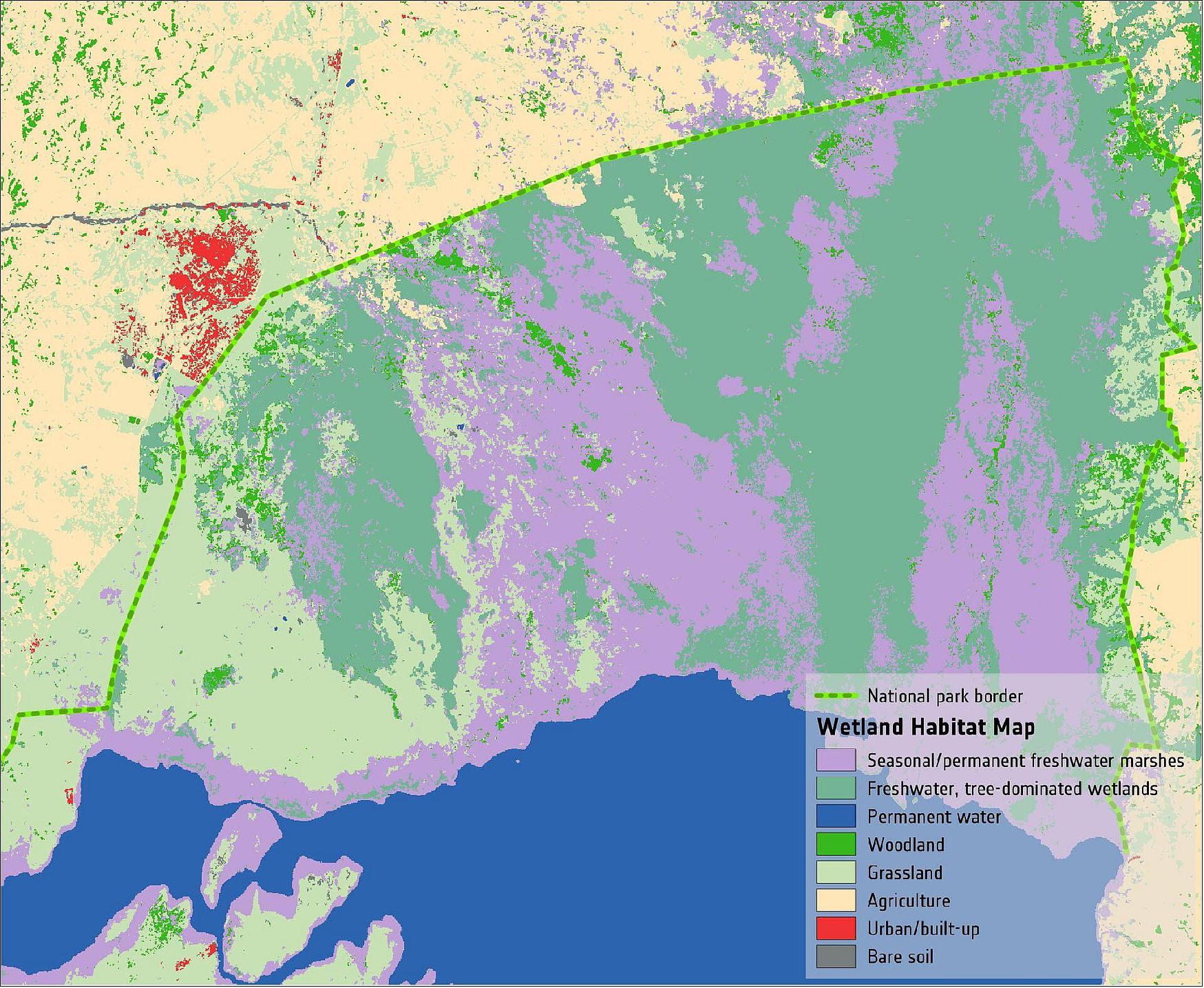
New maps generated through ESA’s GlobWetland Africa project, show the dynamics of water and wetland areas in Uganda, specifically Lake George (see figures 7 and 8). The maps combine optical and radar observations using long-time data sets from the Copernicus Sentinel-1 and Sentinel-2 missions, along with the US Landsat mission.
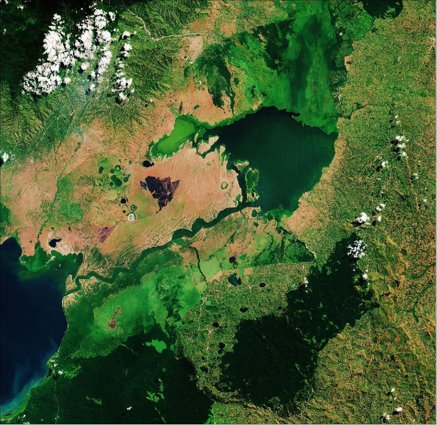
In 1988, Lake George was designated as Uganda’s first Ramsar site, given its importance as a centre for biological diversity. This equatorial lake covers an area of around 250 km2 and has an average depth of around 2.4 meters. Lake George is fed by a complex system of rivers and streams originating from the Rwenzori mountains – supplying a system of permanent swamps surrounding the lake. The wetlands provide a natural living space for a number of mammals including elephants, hippopotamus and antelope. They also provide a habitat for over 150 species of birds including several rare species such as the saddle-billed stork. - Seen from above, the waters of Lake George appear green as a result of the thick concentration of blue-green algae. Metal pollution, mine seepage and agricultural runoff has caused serious pollution to the lake’s waters and are severely impacting the lake’s health. - Lake George drains through the Kazinga Channel in the image’s center. The wide, 32 km long channel connects Lake George with Lake Edward, which lies on the border between Uganda and the Democratic Republic of the Congo. The Kazinga Channel flows through the Queen Elizabeth National Park. The almost 2000 km2 park is known for its wildlife including the African buffalo and the Nile crocodile. The park is also famous for its volcanic features, including volcanic cones and deep craters which can be seen dotted around the image. Many contain crater lakes, including the Katwe crater lake, whose salt deposits have been mined for centuries.
According to the Ramsar Sites Information service, the main threats to biodiversity conservation in Uganda are pollution, use of resources and agriculture, all of which are changing the ecosystem.
Paul Mafabi, Head of Ramsar Administrative Authority for Uganda, comments, “Wetlands are important water systems in Uganda and continue to be highlighted by the UN Sustainable Development Goals. A good starting point for wetland protection and restoration is a good mapping inventory of the wetlands.”
The GlobWetland Africa project was created in collaboration with the African Team of the Ramsar convention, and is a satellite-based toolbox for the conservation, wise-use and effective management of wetlands.
From their vantage point of 800 km high, Earth-observing satellites provide data and imagery on wetlands that can then be used to monitor and manage these precious resources more sustainably.
The toolbox provides African stakeholders with the necessary Earth observation methods and tools to better fulfil their commitments and obligations towards the Ramsar Convention on Wetlands.
Christian Tøttrup, Project lead of GlobWetland Africa, comments, “The tool can help African authorities to make the best use of satellite-based information on wetland extent and condition for better measuring the ecological state of wetlands and hence their capacity to support biodiversity and provide ecosystem services.
“The toolbox can help support questions such as: What is the wetland extent and how has it changed over time? Is the wetland under threat from urbanization, agriculture or aquaculture? Are there are signs of water quality deterioration, such as eutrophication or large sediment loads?”
Given the importance of preserving wetlands around the world, the Earth observation community is joining effort under the Group on Earth Observations Wetlands Initiative, to help countries embrace Earth observation technology in their national wetland monitoring.
Water Resource Management
After more than 3.5 years of activity the final review meeting of the EO4SD on water resources management was held at ESRIN in Frascati on the 28th and 29th of January 2020. 3)
Global water resources are being rapidly exploited through unprecedented population growth and widespread unsustainable management practices. The current pace, magnitude and spatial reach of humankind's impact on water resources is now a very real concern for future development and peace. In simple terms this means that water resources are being polluted and over-exploited on scales never witnessed before. Currently, millions of people still live without access to safe drinking water, mainly in sub-Saharan Africa and Asia. Agricultural irrigation remains by far the largest consumer of freshwater resources, accounting for about 70% of freshwater use, with this number expected to increase by a further 20% by 2050.
In response to the widespread recognition of impending water scarcity, in January 2015, the World Economic Forum declared the water crisis as one of the highest global risks. However, despite this growing concern, a water crisis can be viewed as management crisis, that can be mitigated through the application of best-practices and sound water management policy.
Considering the significant risks of letting a potential water crisis unfold unabated, the new Sustainable Development Goals (SDGs), approved in September 2015, set specific targets for water (SDG 6). This ambitious SDG aims to ensure the availability and sustainable management of water and sanitation for all. One of the central pathways outlined to achieve this goal is through integrated water resources management (IWRM) at multiple levels, including transboundary cooperation (cf. SDG Target 6.5). The successful implementation and monitoring of IWRM initiatives requires access to reliable data and information on key water related challenges. There is now a growing awareness that Earth Observation (EO) data has the potential to serve these data needs. This is especially relevant in the context of Official Developing Assistance (ODA), which normally target regions where policies and management decisions are more often based on sparse and unreliable information.
Objectives
Specifically, for water resource management the EO4SD will seek to demonstrate the benefits and utility of EO services in response to stakeholder requirements for water resources monitoring and management at local to basin scales.
Some of the key water related priority areas where EO-based geo-information is needed include:
• River basin characterization and change monitoring (e.g. hydrological network mapping, long-term climate change analysis)
• Water supply and sanitation (e.g. monitoring of water quality, extent and level of lakes and rivers to support management for agricultural, industrial and urban water use)
• Hydrological management (e.g. modeling and forecasts of runoff, river discharge and groundwater abstraction)
• Water productivity (e.g. mapping of biomass production, evapotranspiration and crop type)
• Risk management of natural hydrological hazards (e.g. mapping and forecasting of flooding, drought, landslides)
• Industrial activity assessment (e.g. monitoring of freshwater fisheries, aquaculture, hydropower and mining)
Portfolio
• Monitoring crop and vegetation water demand
• Hydrological modelling and monitoring
• Groundwater mapping and exploitation
• Hydrological network mapping
• Industrial activity assessment
• Vegetation and land cover characterization
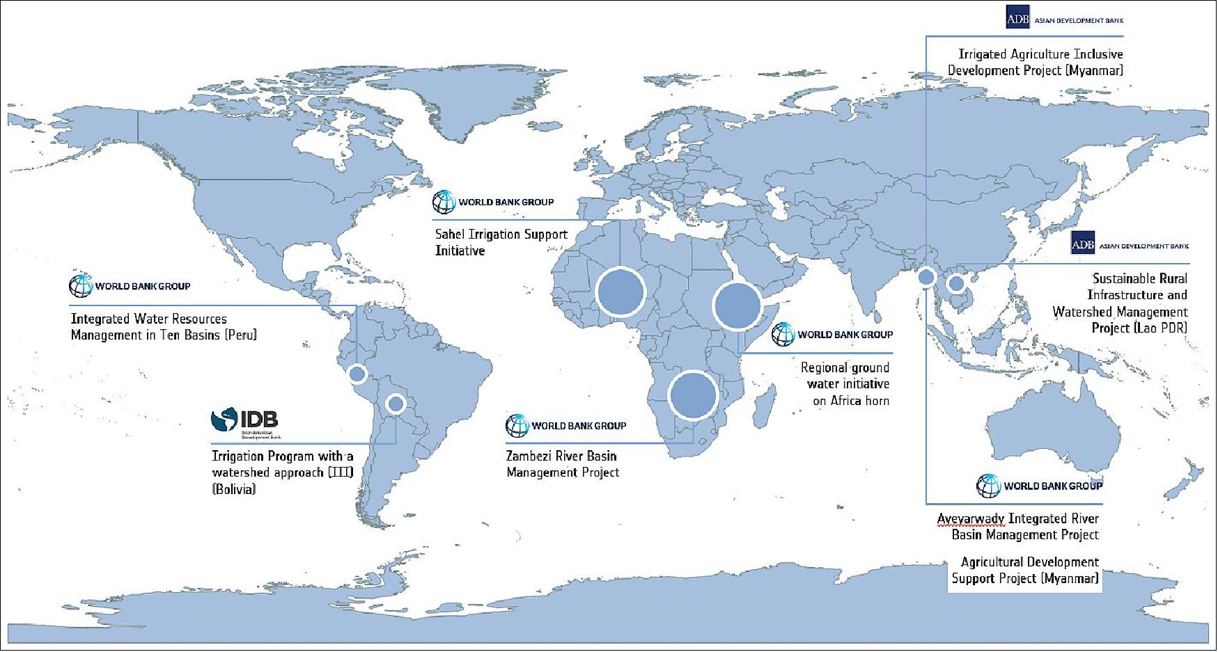
Where We Work
The EO4SD project on water resource management will provide Earth Observation demonstrations on a large-scale in Africa (Sahel, Africa Horn and Zambezi), Asia (Myanmar and Lao PDR) and Latin America (Bolivia and Peru), and within water related operations of major IFI’s including World Bank, Asian Development Bank, Inter-American Development Bank and the Global Environmental Facility.
World Wetlands Day Focuses on Agriculture
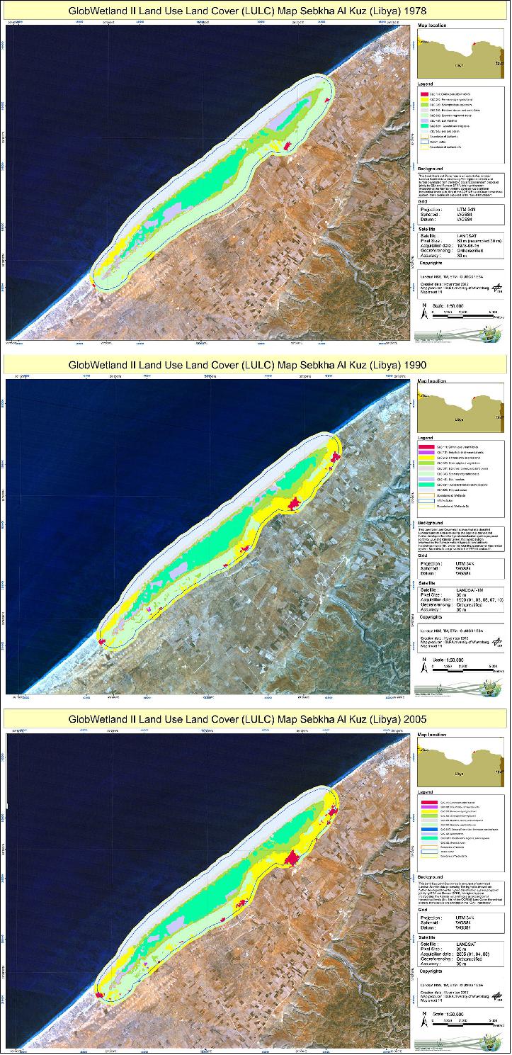
The 2014 World Wetlands Day highlights the need for wetlands and the agriculture sector to work together. ESA’s GlobWetland II project assists Mediterranean countries in the sustainable use of these areas and demonstrates the evolution of wetlands and agricultural patterns over time. 4)
Wetlands are land areas that are permanently or seasonally saturated with water. They play an important role in the local environment and associated plant and animal life.
On 2 February 1971, the ‘Ramsar Convention on Wetlands’ was adopted in the Iranian city of Ramsar to provide the framework for national action and international cooperation for the conservation and wise use of wetlands.
Forty-three years later, the anniversary of that signing is being celebrated under the theme ‘Wetlands and Agriculture: Partners for Growth’.
Agriculture is often seen as a threat to these precious resources as they are drained and reclaimed for farming. But successful agricultural practices can actually support healthy wetlands.
Using imagery from Earth-observing satellites to map changes in wetlands, the GlobWetland II project promotes their sustainable use.
The maps reveal that while Mediterranean wetlands had been principally used for agriculture, less wetland area has been changed by agricultural in the past 10–15 years, indicating that agriculture expansion is no longer a severe threat.
This co-habitation shows that wetlands and the agriculture sector are mutually beneficial. Agriculture needs wetlands for water, pest management, pollination and landscape improvement. At the same time, agricultural land acts as a buffer zone around wetlands, protecting them from developing industrial zones and urban areas.
Recognizing this connection, common strategies for wetland and agro ecosystem-conscious management are on global agendas. Earth observation techniques and information systems, such as the GlobWetland toolbox, provide the appropriate and timely information to cope with water balances and regulation of land use, complex landscapes and spatial patterns.
“We need to find the right balance between the economic demands of agriculture and the necessary wise use of wetlands, which benefits both and is indeed essential for each of them,” said Paul Ouedraogo, Ramsar Convention’s Senior Advisor for Africa.
“Earth observation systems help us to inventory and manage agricultural ecosystems, in contexts where people’s practices – defined by their knowledge – values and traditions affect the biodiversity of a place, its atmosphere, its soil and its water.”
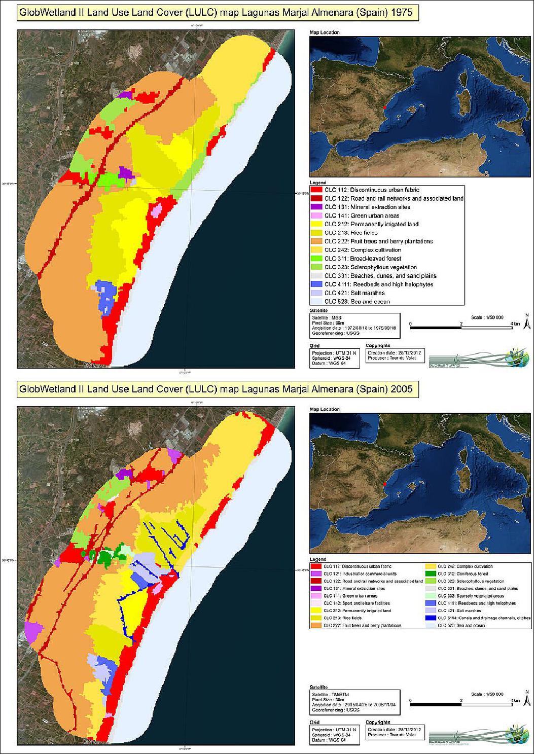
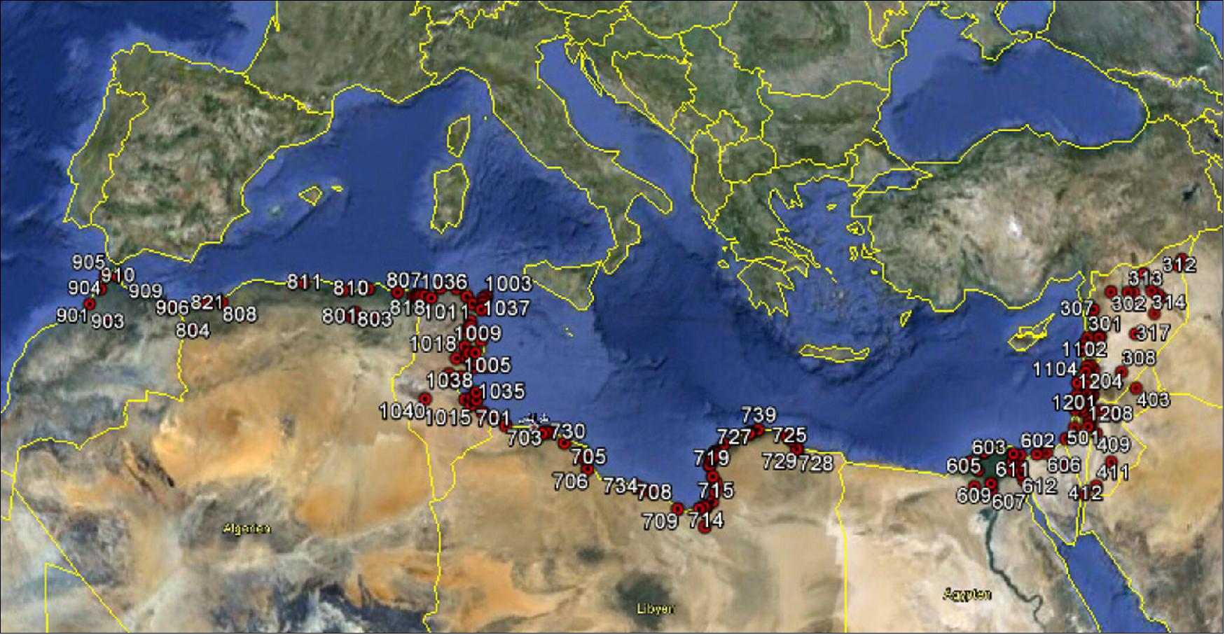
GlobWetland II has just completed its mapping in the coastal zones of 10 countries of the Southern Mediterranean Basin. The maps are available via GlobWetland II WebGIS.
The project is implemented in partnership with Ramsar, the MetWet initiative, the Mediterranean Wetlands Observatory and the 10 countries along the southern Mediterranean Basin, and is funded by ESA’s Data User Element program.
The Mediterranean Wetlands Observatory has extended the work of the GlobWetland II project team and used its ‘toolbox’ to produce additional maps of over 100 wetlands in northern and eastern countries of the Mediterranean basin. The Observatory will publish a report on the status and trends of Mediterranean wetlands later this year.
As GlobWetland II nears its completion, the next venture – GlobWetland Africa – is set for initiation later this year. The new endeavor will collaborate closely with ESA’s TIGER initiative, which trains African water authorities and researchers in exploiting satellite data and Earth observation technology for sustainable water resource management.
GlobWetland Africa will largely benefit from the forthcoming Sentinel-2 mission, being developed under Europe’s Copernicus program.
The large swath of Sentinel-2 satellites, along with their short revisit time and 10 m resolution, will allow for seasonal and permanent changes in wetlands to be accurately monitored.

Monitoring Wetlands for Sustainable Water Management
February 2013: Wetlands play a major role in the availability and quality of water, containing most of the water used to meet human needs. ESA’s GlobWetland II project is helping Mediterranean countries to monitor these precious resources. 5)
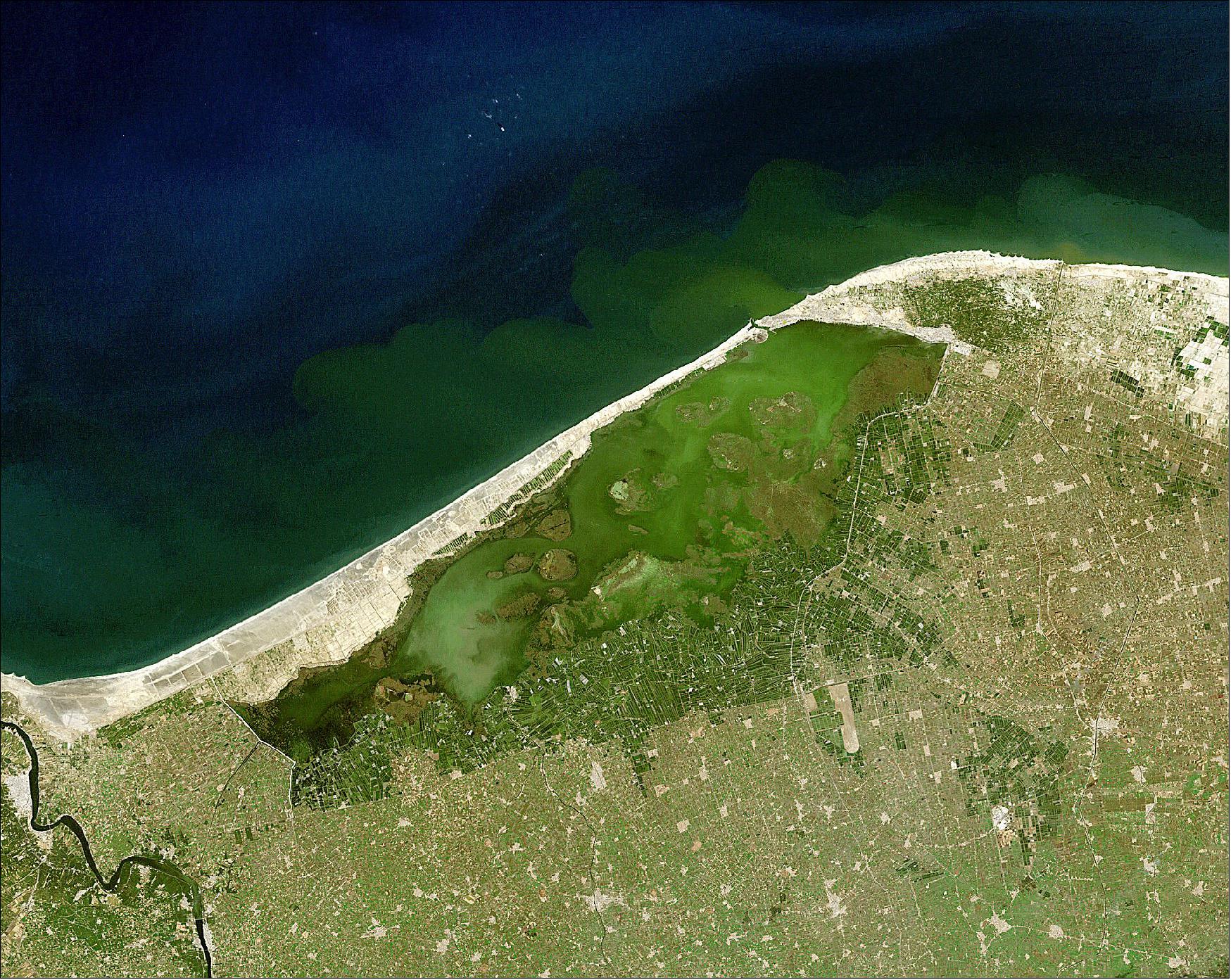
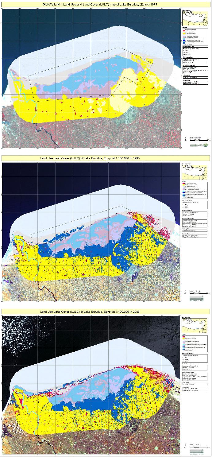
Located within the Nile River Delta, Egypt’s Lake Burullus has undergone major changes in the past 40 years.
Urban settlements have flourished around the lake, and from 1973 to 1990 the area saw a sharp increase in aquaculture.
As a result of increased waste water in the lake (largely due to aquaculture), there has been an overall decrease of salt marsh vegetation in the lake itself, in some parts replaced by reed beds.
From 1990 onwards, however, a decrease in fishponds in the western part of the main lake was observed through ESA’s GlobWetland II project.
Lake Burullus is just a small portion of the over 200 million hectares worldwide considered wetlands of international importance by the Ramsar Convention – an intergovernmental treaty for the sustainable use of wetlands.
Wetlands are integral components in the hydrological cycle and contain most of the water used to meet human needs. The wise use of wetlands is essential for the delivery of sustainable water management that also promotes sustainable economic and social development.
‘Wetlands and water management’ was the theme of this year’s World Wetlands Day, observed last Saturday on the anniversary of the signing of the Ramsar Convention.
The theme was specifically selected to coincide with 2013 as the UN-declared International Year of Water Cooperation – and ESA is at the forefront by providing satellite data for sustainable water management.
Launched in 2010, ESA’s GlobWetland II project contributes to the establishment of a Global Wetlands Observing System (G-WOS) in accordance with Ramsar’s 2009–15 strategic plan.
The project is implemented in partnership with Ramsar, the MetWet initiative, the Mediterranean Wetlands Observatory and the ten countries along the southern Mediterranean Basin.
The user-friendly toolbox is currently being used to produce about 1800 thematic maps for a sample of 200 Mediterranean wetlands, from Morocco to Syria.
The mapping results reveal that although, in general, wetland extents have gradually decreased mainly due to agriculture and urbanization pressures, there are still unaffected areas where changes are not large or even sometimes where wetlands’ extent has increased.
References
1) ”Earth observation vital in monitoring wetland waters,” ESA Applications / Observing the Earth, 02 February 2021, URL: https://www.esa.int/Applications/Observing_the_Earth
/Earth_observation_vital_in_monitoring_wetland_waters
2) ”Space key to wetland conservation,” ESA / Applications / Observing the Earth, 05 February 2020, URL: https://www.esa.int/Applications/Observing_the_Earth/Space_key_to_wetland_conservation
3) ”EO4SD-Water r project coming to an end, January 2020, URL: http://eo4sd-water.net/
4) ”World Wetlands Day focuses on agriculture,” ESA / Applications / Observing the Earth, 31 January 2014, URL: https://www.esa.int/Applications/Observing_the_Earth/World_Wetlands_Day_focuses_on_agriculture
5) ”Monitoring wetlands for sustainable water management,” ESA / Applications / Observing the Earth, 08 February 2013, URL: https://www.esa.int/Applications/Observing_the_Earth
/Monitoring_wetlands_for_sustainable_water_management
The information compiled and edited in this article was provided by Herbert J. Kramer from his documentation of: ”Observation of the Earth and Its Environment: Survey of Missions and Sensors” (Springer Verlag) as well as many other sources after the publication of the 4th edition in 2002. - Comments and corrections to this article are always welcome for further updates (eoportal@symbios.space).
Space, Key to Wetland Conservation Water Resource Management
World Wetlands Day Focuses on Agriculture
Monitoring Wetlands for Sustainable Water Management
References Back to top