IRNSS (Indian Regional Navigational Satellite System)
Non-EO
ISRO
Position and Navigation
Quick facts
Overview
| Mission type | Non-EO |
| Agency | ISRO |
| Launch date | 01 Jul 2013 |
IRNSS (Indian Regional Navigational Satellite System)
Spacecraft Launch Mission Status Payload Complement Ground Segment References
IRNSS is an autonomous regional satellite navigation system being developed by ISRO (Indian Space Research Organization). The government of India approved the project in May 2006, with the intention of the system to be completed and implemented in the timeframe 2016.
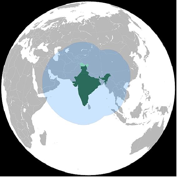
The objective of the project is to implement an independent and indigenous regional spaceborne navigation system for national applications. The IRNSS design requirements call for a position accuracy of < 20 m throughout India and within the region of coverage extending about 1500 km beyond. The system is expected to provide accurate real-time position, velocity and time observables for users on a variety of platforms with a 24 hour x 7 day service availability under all weather conditions. 1) 2) 3) 4)
The IRNSS is being developed parallel to the GAGAN (GPS Aided GEO Augmented Satellite Navigation) program, the ISRO SBAS (Satellite Based Augmentation System) version of an overlay system for GNSS signal corrections. 5) 6) 7)
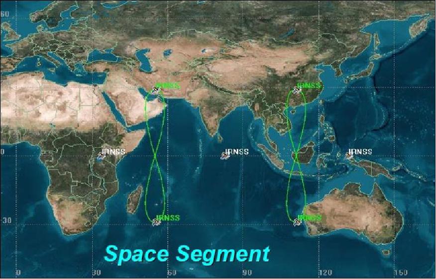
The proposed IRNSS system will consist of a constellation of seven satellites and a supporting ground segment. Three of the satellites in the constellation will be placed in a geostationary orbit and the remaining four in a geosynchronous inclined orbit of 29º relative to the equatorial plane. Such an arrangement would mean all seven satellites would have continuous radio visibility with Indian control stations.
ISRO has filed for 24 MHz bandwidth of spectrum in the L5-band (1164 – 1189 MHz) for IRNSS and for the second signal in S-band (2483.5 – 2500 MHz).
The IRNSS constellation architecture consists of the following elements:
• Space segment: The IRNSS satellites carry a navigation payload in a redundant configuration. A separate C-band transponder for precise CDMA ranging is included in the payload configuration. The important functions of the IRNSS payload are: Transmission of the navigational timing information in the L5 bands; transmission of navigation, timing information in S-band; generation of navigation data on-board, CDMA ranging transponder for precise ranging.
The navigation payload will have the following subsystems: NSGU (Navigation Signal Generation Unit), Atomic clock unit, comprising of Rubidium atomic clocks, clock management and control unit, frequency generation unit, modulation unit, high power amplifier unit, power combining unit and navigation antenna.
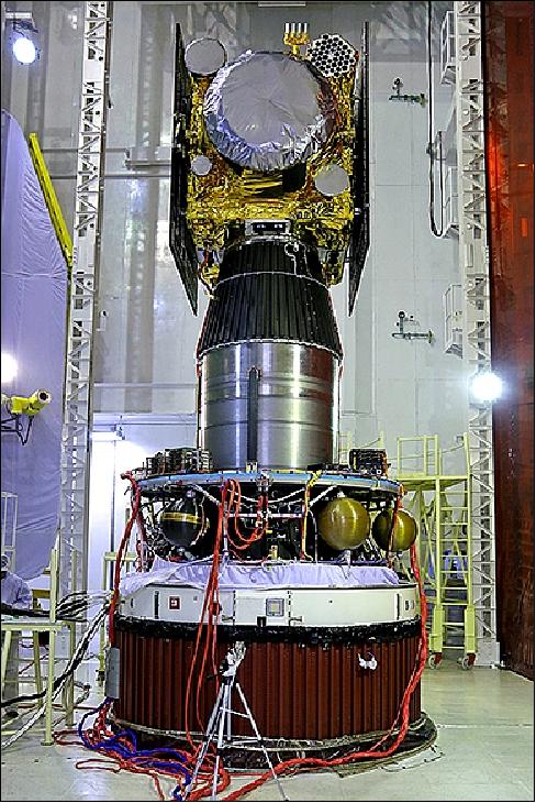
The IRNSS spacecraft are dedicated for navigation services and they are configured to be of a class that can be launched by the Indian launcher PSLV. The design incorporates most of the proven subsystems available indigenously tailoring it specifically for the navigation.
• Ground segment: The ground segment is responsible for the maintenance and operation of the IRNSS constellation. It contains a whole complement of the elements required for a basic constellation and is mainly comprised of:
- Master Control Center for spacecraft control and navigation, IRNSS tracking and integrity monitoring stations, CDMA ranging stations, uplinking and telemetry stations, communication links and network timing center.
• User segment: Specially designed receivers and antennas are needed to receive the IRNSS signals. The receivers are also planned for receiving multi-constellation signals inclusive of GPS, GLONASS, Galileo and IRNSS. It is planned to broadcast the time difference between the IRNSS time and the time of the other constellations to enable the users to take advantage of the signals available to them.
Spacecraft
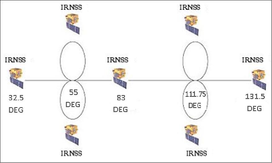
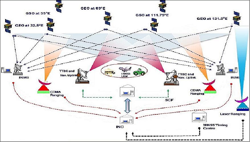
The space segment consists of seven satellites: 8) 9) 10) 11)
• 3 satellites in GEO (Geostationary Orbit) at 32.5°, 83° and 131.5° East.
• 4 satellites in geosynchronous orbit placed at inclination of 29° with longitude crossing at 55° and 111.75° East
• Two spare satellites are also planned
• The satellites are specially configured for the navigation. Same configuration for GEO and GSO which is desirable for the production of the satellites.
• Plans call for the IRNSS satellites to be launched by the Indian launcher PSLV
• The first satellite will be launched in the summer of 2013. The subsequent launches are planned once in six months. The full constellation will be operational by 2016.
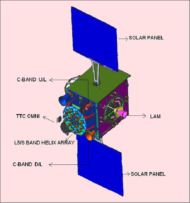
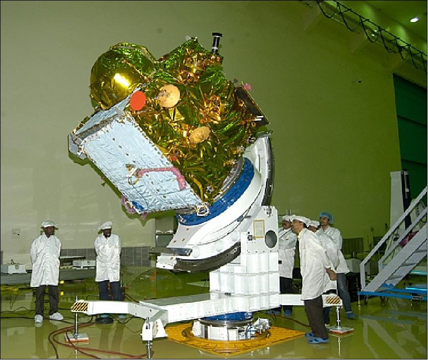
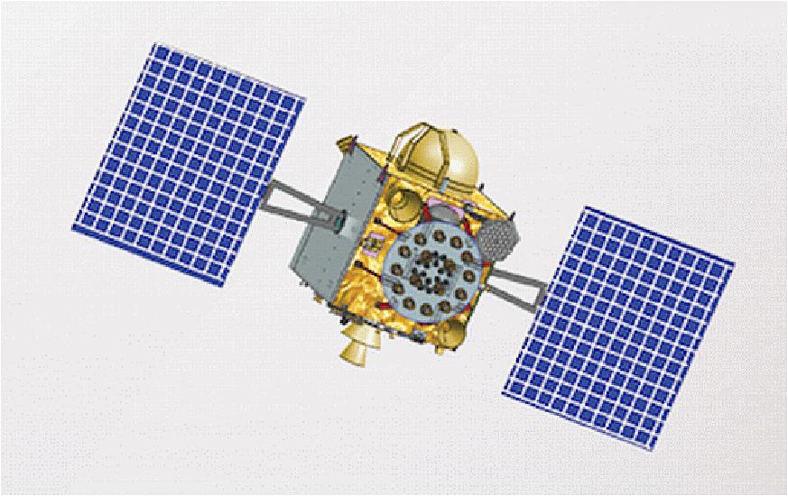
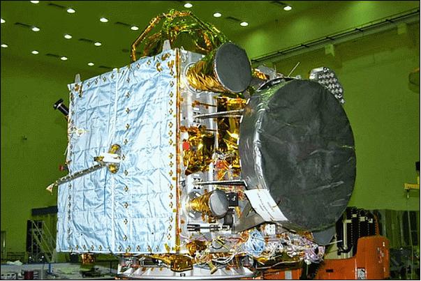
The IRNSS satellites are configured around the spacecraft bus I-1K, which is similar to ISRO's meteorological satellite, Kalpana-1, with a dry mass of ~600 kg and a launch mass of 1,425 kg. The solar panels are generating a power of 1600 W (with a payload power requirement of 900 W.
The spacecraft are 3-axis stabilized. Attitude control of the satellite is provided with yaw steering, a capability to optimize the use of the solar panels and to support the thermal control of the satellite.
Launch mass | 1432 kg, dry mass of 614 kg |
Spacecraft size (launch configuration) | 1.58 m x 1.5 m x 1.5 m |
EPS (Electrical Power Subsystem) | Two solar panels generating 1660 W, one lithium-ion battery of 90 Ah capacity |
ADCS (Attitude Determination and Control Subsystem) | Zero momentum system, orientation input from sun & star sensors and gyroscopes; reaction wheels, magnetic torquers and 22 Newton thrusters as actuators |
Mission design life | 10-12 years |
Propulsion | 440 N LAM (Liquid Apogee Motor) with twelve 22 N thrusters |

Launch
Launch: The IRNSS-1A spacecraft was launched on July 1, 2013 on the PSLV-C22 vehicle from SDSC (Satish Dhawan Space Center) SHAR on the east coast of India. Use of the PSLV 'XL' configuration. After a flight of 20 minutes and 17 seconds, the IRNSS-1A satellite was injected to the intended GTO (Geostationary Transfer Orbit) of 282.46 km x 20,625.37 km. 12) 13)
After injection, the solar panels of IRNSS-1A were deployed automatically. ISRO's Master Control Facility (at Hassan, Karnataka) assumed the control of the satellite.
Launch: The IRNSS-1B spacecraft was launched on April 4, 2014 (11:44 UTC) on the PSLV-C24 vehicle (XL configuration) from SDSC SHAR. After a flight of about 19 minutes, IRNSS-1B Satellite, with a mass of 1432 kg, was injected to an elliptical orbit of 283 km x 20,630 km, which is very close to the intended orbit. 14)
After injection, the solar panels of IRNSS-1B were deployed automatically. ISRO's Master Control Facility (at Hassan, Karnataka) assumed the control of the satellite. In the coming days, five orbit maneuvers will be conducted from Master Control Facility to position the satellite in its GSO (Geosynchronous Circular Orbit) at 55ºE longitude. 15)
Launch: The IRNSS-1C was launched on Oct. 15, 2014 (20:02:00 UTC) on the PSLV-C26 vehicle from SDSC (launch mass of 1425.4 kg). IRNSS-1C was initially injected into a GTO and then raised into GEO (4th orbit raising maneuver on Oct. 20, 2014). IRNSS-1C is the geostationary satellite in the IRNSS system, located at 83ºE. 16)
Launch: The IRNSS-1D spacecraft was launched on March 27, 2015 (11:49:00 UTC) on the PSLV-C27 vehicle from SDSC (launch mass of 1425.4 kg). 17)
Launch: The IRNSS-1E spacecraft was launched on January 20, 2016 (04:01:00 UTC) on the PSLV-C31 vehicle from SDSC (launch mass of 1425.4 kg). 18)
Launch: The IRNSS-1F spacecraft was launched on March 10, 2016 (10:31:00 UTC) on the PSLV-C32 vehicle from SDSC (launch mass of 1425.4 kg).This is the 33rd consecutively successful mission of PSLV and the twelfth in its 'XL' configuration. 19)
Launch: The IRNSS-1G spacecraft was launched on April 28, 2016 (07:50 UTC) on the PSLV-C33 vehicle from SDSC (launch mass of 1425.4 kg). As in the previous six launches of IRNSS satellites, PSLV-C33 uses ‘XL' version of PSLV equipped with six strap-ons, each carrying 12 tons of propellant. 20)
Launch: The IRNSS-1H spacecraft was launched on Aug. 31, 2017 on the PSLV-C39 vehicle from SDSC. Launch Failure. The satellite got separated internally, but the heat shield did not open as expected, causing the satellite to be stuck inside the upper stage of the rocket. The reasons are still being analyzed.
Launch: The IRNSS-1I spacecraft was launched on April 11, 2018 (22.34 UTC) on the PSLV-C41 vehicle in XL configuration from SDSC. The IRNSS-1I is the eighth satellite to join the NavIC navigation satellite constellation. 21)
Orbit: The three GEO spacecraft are in the equatorial plane at an altitude of 35,786 km located at 32.5º, 83º and 131.5º E. The four GSO (Geosynchronous Orbit) spacecraft, with an inclination of 29º, are located in two planes with daily longitudinal equator crossings at 55º E and at 111.75º E.
LAM (Liquid Apogee Motor) is used for all orbit raising maneuvers, placing the spacecraft into their GSO or GEO orbits, respectively.
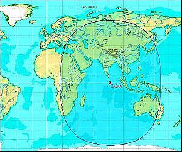
The coverage provided by the constellation encompasses a longitude from 30º to 130º and a latitude region of 30º S to 50º N.
IRNSS spacecraft | Longitude (E) | Inclination | RAAN | Launch Date |
1A | 55.0º | 29º (±2) | 135º | July 1, 2013 |
1B | 55.0º | 29º (±2) | 310º | April 4, 2014 |
1C | 83.0º |
| 274º | October 15, 2014 |
1D | 111.75º | 29º (±2) | 135º | March 27, 2015 |
1E | 111.75º | 29º (±2) | 310º | January 20, 2016 |
1F | 32.5º | ± 5º | 270º | March 10, 2016 |
1G | 129.5º | ± 5º | 270º | April 28, 2016 |
1H |
|
|
| Aug. 31 2017 (launch failure) |
1I | 55.0º | 29º |
| April 11, 2018 |

Mission Status
• April 12, 2018: ISRO's PSLV-C41 successfully launched the 1425 kg IRNSS-1I Navigation Satellite (on April 11, 2018, 22.34 UTC) from SDSC (Satish Dhawan Space Center) SHAR, Sriharikota. After separation, the solar panels of IRNSS-1I were deployed automatically. ISRO's Master Control Facility (MCF) at Hassan, Karnataka took over the control of the satellite. In the coming days, orbit maneuvers will be performed from MCF to position the satellite at 55º East longitude in the planned Geosynchronous Orbit with an inclination of 29º to the equator. 23)
• August 28, 2017: India is launching a new satellite IRNSS-1H next week to replace the malfunctioning IRNSS-1A. IRNSS-1A, a component of India's very own global positioning system (NavIC), had developed a glitch after its three rubidium atomic clocks had stopped functioning earlier this year. 24)
- IRNSS with the operational name of NavIC, will be joined by an eighth satellite IRNSS-1H which will serve as a backup for IRNSS-1A on 31st August. However, IRNSS-1H experienced a launch failure.
• July 7, 2017: ISRO is set to offer GPS from its own navigation system for mobile users from next year, aiming to make it more accurate than foreign competitors' products. - ISRO plans got a temporary setback with the malfunctioning of one of the NavIC (Navigation with Indian Constellation) satellites. The agency will launch a replacement satellite for IRNSS-1A in August. 25)
- ISRO has already achieved the miniaturization of chipsets that are used in wireless devices. The agency's SAC (Space Application Center ) is reportedly working on the development of NavIC user receiver, which is key to finding user position. SAC has the technology for this in larger form.
- SAC is working on different kinds of hardware for its applications. "Our SCL (Semiconductor Laboratory ) in Chandigarh has developed the digital hardware and tested it. Now, the radio frequency front-end hardware is expected to hit the markets next month," The New Indian Express quoted Tapan Misra, director of Ahmedabad-based SAC.
- ISRO's attempts to develop the chipsets with the private sector partnership didn't materialize due to high investment requirements. The SCL developed the digital chips and for manufacturing prototypes of RF Front-End hardware, it has roped in the US-based firm Tower Jazz, which specializes in silicon germanium technology suited for increasing bandwidth. ISRO has planned to set up a fabrication facility with silicon germanium processing technology in SCL.
- The Indian space agency retains the intellectual property rights of the design. It will integrate both digital and RF platforms into one device. The integrated technology is expected to offer greater bandwidth and low power digital circuit implementations.
- The final version would be an 11-channel chipset (7 NavIC satellites and four GPS satellites) operating under dual frequency (S- and L- bands), which Misra says actually delivered higher accuracy than GPS.
- NavIC will provide standard positioning service to all users with a position accuracy of 5 m. The GPS, on the other hand, has a position accuracy of 20-30 m.
- "ISRO has proved it can build robust and cost-effective indigenous technologies. NavIC, as we are informed, will be operational with just 7 satellites, compare that to China's Beidou, which is a constellation of 35 satellites," Dr. Mayank N. Vahia, astrophysicist at the TIFR (Tata Institute of Fundamental Research) in Mumbai, told Sputnik.
• June 26, 2017: A seven-satellite, indigenous IRNSS (Indian Regional Navigation Satellite System), created by ISRO (Indian Space Research Organization) to service the global positioning data needs of the defence forces, has run into problems with a number of rubidium atomic clocks crucial to providing data failing or developing inherent problems. 26)
- ISRO had announced in July last year that all three atomic clocks on IRNSS-1A, the first of the seven satellites that was launched on July 1, 2013, had malfunctioned, rendering that satellite ineffective. Now, sources associated with ISRO's satellite navigation program say four more atomic clocks on the other six satellites are not performing as required.
- Timekeeping is vital to GPS because it pinpoints a location on Earth by measuring the travel time of radio signals between the location and satellites in space. Since radio signals travel at the speed of light — 300,000 km/second — inaccuracy of one millisecond can send navigation information awry by a distance of 300 km on Earth.
- ISRO plans to launch a replacement satellite called IRNSS-1H in July-August to compensate for the loss of IRNSS-1A, although it is yet to announce the failure of more atomic clocks, which has not incapacitated the clock systems on the other six satellites.
- The failure of seven of the 21 clocks in the constellation has, however, raised concerns. "Six of the seven satellites are still working," said a senior ISRO official associated with the program. "There are, however, inherent hardware problems on the rubidium atomic clocks in some of these. These clocks developed the same problems when used in the Galileo satellite system by ESA (European Space Agency)."
- ESA reported last January that anomalies had occurred in three of 36 RAFS (Rubidium Atomic Frequency Standard) clocks in the 18-satellite Galileo system, although none of the satellites were affected. ESA had said, "These failures all seem to have a consistent signature, linked to probable short circuits, and possibly a particular test procedure performed on the ground...."
• January 30, 2017: India will launch one of its back up navigation satellites this year as a replacement to IRNSS-1A satellite, whose three atomic clocks have failed, a top official of Indian space agency ISRO said on Jan. 30. The official denied the existence of similar problems with the rubidium atomic clocks in another navigation satellite. 27)
- "The atomic clocks have failed in only one satellite of IRNSS (Indian Regional Navigation Satellite System) with an operational name of NavIC (Navigation Indian Constellation). We will be launching the stand-by satellite this year. All other six satellites are operational and are providing the navigation data," said AS Kiran Kumar, chairman of ISRO (Indian Space Research Organisation). He said the atomic clocks were imported and ISRO would take up the issue with the foreign supplier.
- Each satellite has three clocks and a total of 27 clocks for the navigation satellite system were supplied by the same vendor. The clocks are important to provide precise data.
- ISRO has downplayed the failure of three atomic clocks onboard one of the satellites of the India's home grown ambitious IRNSS. The failure of three atomic clocks is not causing much worry to Indian scientists as they cited similar instance earlier this month in Europe, where three rubidium atomic clocks and six hydrogen maser clocks onboard Galileo failed. 28)
- The Rubidium atomic clocks were manufactured by the Swiss company Spectracom. However, India's CSIR-NPL (Council of Scientific & Industrial Research-National Physical Laboratory) has developed and transferred the critical technology of Rubidium atomic clock for space applications to ISRO. — A model has been developed at CSIR-NPL and is undergoing further developments at ISRO/SAC (Satellite Applications Center) before being integrated in the payload of the Indian Regional Navigation Satellite system.
• April 28, 2016: After the PSLV-C33 lift-off at 12:50 pm IST (7:50 UTC), the subsequent important flight events, namely, strap-on ignitions and separations, first stage separation, second stage ignition, heat-shield separation, second stage separation, third stage ignition and separation, fourth stage ignition and satellite injection, took place as planned. After a flight of 19 minutes 42 seconds, IRNSS-1G was injected into an elliptical orbit of 283 km x 20,718 km inclined at an angle of 17.867º to the equator (very close to the intended orbit) following which the satellite successfully separated from the PSLV fourth stage. 29)
- After separation, the solar panels of IRNSS-1G were deployed automatically. ISRO's MCF (Master Control Facility) at Hassan, Karnataka, took over the control of the satellite. In the coming days, four orbit maneuvers will be conducted from MCF to position the satellite in the Geostationary Orbit at 129.5º East longitude.
- According to ISRO, the other six satellites of the constellation are functioning satisfactorily from their designated orbital positions.
- A number of ground facilities responsible for satellite ranging and monitoring, generation and transmission of navigation parameters, etc., have been established in eighteen locations across the country. Today's successful launch of IRNSS-1G, the seventh and final member of IRNSS constellation, signifies the completion of the IRNSS constellation.
• The IRNSS-1E spacecraft, launched on January 20, 2016, was injected into into the sub-geosynchronous transfer orbit with a perigee of 282 km and an apogee of 20,655 km with an inclination of 19.21º, very close to the intended orbit. ISRO reported that the satellite is in good health and its solar panels have been deployed. After four orbit-raising maneuvers using the satellite's onboard motor, it will be positioned at its allotted GSO (Geosynchronous Orbit) with a 28.1º inclination at a longitude of 111.75º East. 30)
- ISRO said the four IRNSS satellites already in space have started functioning from their designated slots and their "signal-in-space" has been validated by various agencies inside and outside the country. The current achieved position accuracy is 20 meters over 18 hours of the day with the four satellites. With the launch of IRNSS-1E and subsequent -1F and -1G satellites in February and March 2016, the IRNSS constellation will be complete for total operational use.
• October 9, 2015: A. S. Kiran Kumar, chairman of ISRO, announced at the 2nd GNSS ( Global Navigation Satellite System) User Meet at ISAC (ISRO Satellite Center), that ISRO is looking to extend in the near future the GAGAN (GPS Aided Geo Augmented Navigation) and IRNSS services to the SAARC (South Asian Association for Regional Cooperation) countries. 31)
- IRNSS applications include terrestrial, aerial and marine navigation, precise timing, disaster management, mapping and geodetic data capture, automated logistics in factories, construction sites and mines, vehicles tracking and fleet management, terrestrial navigation for hikers and travellers and integration with mobile phones. Surveying emergency response, business solutions, geographical data collection, natural resources, land management, scientific research and geodynamics are some of GAGAN's applications.
- Of the seven satellites of IRNSS constellation, four are already in orbit while the remaining three will be in place by March 2016. Also, two satellite of the GAGAN system are also in orbit and two more have to be launched.
• April 11, 2015: The health of the IRNSS-1D spacecraft is normal. The station acquisition maneuvers for IRNSS 1D were successfully carried out. The performance is nominal. IRNSS-1D has been positioned at its assigned orbital slot of 111.75º E. The orbital period is 23 hr 55 min 59 sec. In Orbit Testing of the satellite is in progress. 32)
• April 1, 2015: The fourth and final orbit raising operation of IRNSS-1D is successfully completed by firing the Apogee Motor for 493 seconds, at 06 42 hrs IST, on on April 01, 2015. The orbital parameters are: Perigee: 35556 km, Apogee: 35603 km, Inclination: 30.463º and the orbit period: 23hr 45min. 33)
• Nov. 26, 2014: The health of IRNSS -1C spacecraft is normal. All the subsystems are functioning nominally. The characterization of navigation payloads and TTC systems were completed and the navigation information are regularly sent to the spacecraft. 34)
• Feb. 2014: The IRNSS-1A spacecraft is operating nominally. The SIS (Signal In Space) was qualified. 35)
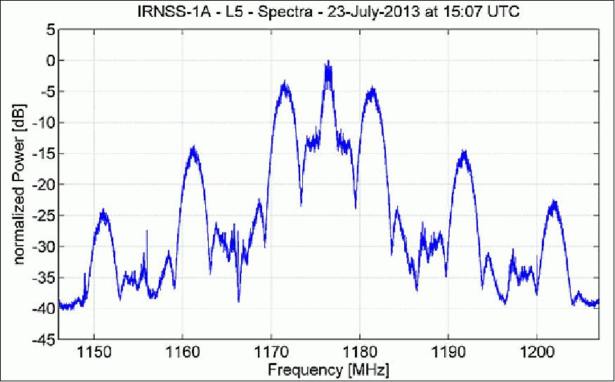
• Sept. 1, 2013: The spectrum of signals from IRNSS-1A, as recorded by DLR (German Aerospace Center) researchers in late July, appears to be consistent with a combination of BPSK(1) and BOC(5,2) modulation. Figure 10 shows that, centered at 1176.45 MHz, the signal has a single symmetrical main lobe and a number of side lobes characteristic of the signal structure that the Indian Space Research Organization (ISRO) announced would be used for IRNSS transmissions in the L-band. 36)
• July 31, 2013: All IRNSS-1A navigation and ranging payload IOTs (In Orbit Tests) are completed. All operations are nominal.
• July 17, 2013: The IRNSS-1A spacecraft was positioned into its geosynchronous orbit (55ºE, inclination of 29º). Five orbit raising maneuvers were conducted from GTO to GSO.
- All operations are normal.
- In Orbit Test is in progress.
• July 8, 2013: Orbit raising maneuvers were completed with the fifth AMF (Apogee Motor Firing) on July 06, 2013 and performance is normal.
- Satellite is in GSO (Geo-Synchronous Orbit) with 27º inclination at 44º E longitude
- The present orbital parameters are : apogee 35870 km, perigee 35484 km and orbital period is 23 h 50 min.
- All the spacecraft subsystems were evaluated, they are functioning normally.
Sensor Complement
Navigation Payload
Each satellite has two payloads : the Navigation payload and the CDMA ranging payload in addition with a retroreflector array. The payload generates navigation signals at L5 and S-band. Both L5 and S-band consists of two downlinks. The design of the payload makes the IRNSS system interoperable and compatible with the GPS and Galileo constellations. 37)
• A highly accurate Rubidium atomic clock is part of the navigation payload.
- L5-band downlink center frequency: 1176.45 MHz, bandwidth of 24 MHz,RHCP (Right Hand Circular Polarization)
- S-band downlink center frequency: 2492.028 MHz, bandwidth of 16.5 MHz, RHCP
• The ranging payload of IRNSS-1 consists of a C-band transponder which facilitates accurate determination of the spacecraft range.
- C-band uplink: 6700 – 6725 MHz, RHCP; downlink: 3400-3425 MHz, LHCP (Left Hand Circular Polarization).
• IRNSS-1 carries also corner cube retroreflectors for laser ranging.
Ground Segment
The IRNSS ground segment includes the major systems for controlling the satellite constellation and will consist of the IRNSS Spacecraft Control Facility (IRSCF), IRNSS Navigation Control Facility, IRNSS Range and Integrity Monitoring Stations , ranging stations, a timing center, IRNSS TTC and uplink stations, and the IRNSS Data Communication Network.
IRNSS Ground Segment Elements:
• IRSCF (IRNSS Satellite Control Facility). IRSCF controls the space segment through Telemetry Tracking & Command network. In addition to the regular TT&C operations, IRSCF also uplinks the navigation parameters generated by the INC.
- IRTTC (IRNSS TTC and Land Uplink Stations)
- IRSCC (IRNSS Satellite Control Center)
• IRIMS (IRNSS Range and Integrity Monitoring Stations). IRIMS perform continuous one way ranging of the IRNSS satellites and are also used for integrity determination of the IRNSS constellation.
• INC (ISRO Navigation Center), located at Byalalu. INC is the nerve center of the IRNSS Ground Segment. INC primarily generates navigation parameters.
• IRDCN (IRNSS Data Communication Network). IRDCN provides the required digital communication backbone to IRNSS network.
Seventeen IRIMS sites will be distributed across the country for orbit determination and ionospheric modeling. Four ranging stations, separated by wide and long baselines, will provide two-way CDMA (Code Division Multiple Access) ranging. The IRNSS timing center will consist of highly stable clocks. The navigation center will receive all this data through communication links, then process and transmit the information to the satellites. 38)
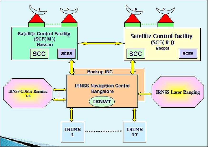
The ISRO Navigation Centre (INC), established at Indian Deep Space Network (IDSN) complex at Byalalu, about 40 km from Bangalore, was inaugurated onMay 28, 2013. 39)
IRNSS will have a network of 21 ranging stations geographically distributed primarily across India. They provide data for the orbit determination of IRNSS satellites and monitoring of the navigation signals. The data from the ranging/monitoring stations is sent to the data processing facility at INC where it is processed to generate the navigation messages. The navigation messages are then transmitted from INC to the IRNSS satellites through the spacecraft control facility at Hassan/Bhopal. The state of the art data processing and storage facilities at INC enable swift processing of data and support its systematic storage.
User Segment
The user segment consists of IRNSS receivers operating in:
• Single frequency (L5 at 1176.45 MHz or S-band at 2492.028 MHz)
• Dual frequency (L5 and S-band)
The single frequency and dual frequency receivers shall receive both SPS (Special Positioning System), which is provided to all users, and RS (Restricted/Authorized Service) signals, which is an encrypted service provided only to authorized users.
The IRNSS user receiver calculates its position using the timing information embedded in the navigation signal, transmitted from the IRNSS satellites. The timing information being broadcast in the navigation signal is derived from the atomic clock onboard the IRNSS satellite. 40)
The IRNWT (IRNSS Network Time) is determined from a clock ensemble composed of the cesium and hydrogen maser atomic clocks at the INC (Indian Navigation Centre) ground stations. As with UTC, IRNWT is also a weighted mean average time, but with two substantial differences. IRNWT will be made available in real time and is a continuous time without leap seconds. The IRNSS satellites carry a rubidium atomic frequency standard onboard. At INC through navigation software, these onboard clocks are monitored and controlled. The deviation between each of the satellite and IRNWT is modeled with a quadratic function of time, and the parameters of this model are calculated and transmitted as a part of the IRNSS broadcast navigation messages.
The parameters are often called as clock bias (A0) or the clock offset (in seconds), drift (A1) or the relative frequency instability (in seconds/second) and aging (A2), also referred to as relative frequency shift (in seconds/second2). Apart from these corrections, any IRNSS users should consider the necessary relativistic time adjustment. With these adjustment parameters, which are usually calculated once per day, are then transmitted to the satellites, thus the satellite clock errors are expected to be well within 5-10ns which fulfills the requirement.
The estimated accuracy is < 20 m over the Indian ocean region, and < 10 m over main land India.
IRNSS Signals
The IRNSS constellation is expected to provide a position accuracy (2σ) of better than 20 m over India and a region extending outside the Indian land mass to about 1,500 km. The system will provide two types of services: (Ref. 4)
1) SPS (Standard Positioning Service)
2) RS (Restricted/Authorized Service)
Both of these services will be provided at two frequencies, one in the L5 band and the other in S-band.
SPS will use bi-phase shift keying BPSK (1) modulation, whereas the RS service will employ binary offset carrier (BOC (5, 2)) modulation. An additional BOC pilot signal is being provided for the RS Service in order to help provide better acquisition and performance. As each L5-band and S-band contains three signals, the IRNSS design adds an interplex signal in order to maintain the constant envelope characteristic of the composite signal.
The transmission is done using the L-band and S-band helix array antenna to provide global coverage in right-hand circularly polarized (RHCP) signals. Thus, user receivers can operate in single-and/or dual-frequency mode.
Timing group delay:
The time of radiation of the navigation signals on each carrier frequency and among frequencies is not synchronized due to the different digital and analog signal paths that each signal must travel from the IRNSS satellite signal generator to the transmit antenna. This hardware group delay is defined as a time difference between the transmitted RF signal (measured at the phase center of a transmitting antenna) and the signal at the output of the onboard frequency source.
Three different parameters comprise this group delay: a fixed/bias group delay, a differential group delay and a group delay uncertainty in bias and differential value.
The fixed delay or hardware group delay is a bias term included in the clock correction parameters transmitted in the navigation data and is, therefore, accounted for by the user computations of system time in the appropriate GPS interface specifications. More specifically, this delay represents the amount of time it takes the signal to start from the common clock, travel through each code generator, modulator, up-converter, transmitter, and finally emerge from the satellite antenna.
The hardware group delay uncertainty reflects the variability in the path delay due to changeable conditions in the operational environment and other factors. The effective uncertainty of the group delay will be in the range of few nanoseconds (on the order of 1-3 ns).
Each IRNSS navigation signal has two hardware paths — main and redundant. The hardware will be different for each path in terms of data generator, modulator, up converter, travelling-wave tube amplifier (TWTA), cable, and integration components.
In case of failure, the signal will be diverted from the main subsystem to the redundant subsystem. he delay of main and redundant subsystem will be different and thus cause a difference in the mean path delay based on the selected path for the navigation signal.
Differential group delay is the difference in delays between two navigation signals. It consists of random plus bias components. The mean differential is defined as the bias component and will be either positive or negative. For a given navigation payload redundancy configuration, the absolute value of the mean differential delay shall not exceed a few nanoseconds, i.e., on the order of 15 to 30 ns.
References
1) G Madhavan Nair, "Satellites for Navigation," Press Information Bureau of the Government of India, Aug. 8, 2006, URL: http://www.pibbng.kar.nic.in/feature2.pdf
2) D. Gowrisankar, S. V. Kibe, "India's Satellite Navigation Programme," APRSAF-15 (15th Session of Asia-Pacific Regional Space Agency Forum) Hanoi, Vietnam, Dec. 9-12, 2008, URL: http://www.space.mict.go.th/activity/doc/aprsaf15_17.pdf
3) Surendra Pal, A. S. Ganeshan, K. N. S. Rao, L. Mruthyunjaya, "Indian Regional Navigation Satellite System," Proceedings of the 58th IAC (International Astronautical Congress), International Space Expo, Hyderabad, India, Sept. 24-28, 2007, IAC-07-B2.1.01
4) Parimal Majithiya, Kriti Khatri, J. K. Hota, "Indian Regional Navigation Satellite System," Inside GNSS, January/February 2011, pp. 40-46, URL: http://www.insidegnss.com/auto/IGM_janfeb11-IRNSS.pdf
5) P. K. Jain, "Indian Satellite Navigation Program: An Update," 45th Session of S&T Subcommittee of UN-COPUOS (United Nations Committee on Peaceful Outer Space), Vienna, Austria, Feb. 11-12, 2008, URL: http://www.oosa.unvienna.org/pdf/icg/providersforum/02/pres04.pdf
6) A. Bhaskaranarayana, "Indian IRNSS and GAGAN," 37 th COSPAR Scientific Assembly, Montreal, Canada, July 13-20, 2008., URL: http://www.oosa.unvienna.org/pdf/icg/2008/expert/2-3.pdf
7) A. Singh, S. K. Saraswati, India heads for a regional navigation satellite system,"Coordinates, Vol. II, Issue 11, Nov. 2006, pp. 6-8, URL: http://mycoordinates.org/pdf/Nov06.pdf
8) S. Shivakumar and Indian delegation, "IRNSS Satellite Navigation Program," Proceedings of the 49th Session of UNCOPUOS-STSC (UN Committee on the Peaceful Uses of Outer Space-Scientific and Technical Subcommittee), Vienna, Austria, Feb. 6-17, 2012, URL: http://www.oosa.unvienna.org/pdf/pres/stsc2012/tech-43E.pdf
9) Anand Dwivedi, "Indian Regional Navigation Satellite System- An Overview," United Nations International Meeting on the Applications of Global Navigation Satellite Systems, Vienna, Austria, December 12-16, 2011, URL: http://www.oosa.unvienna.org/pdf/sap/2011/un-gnss/05.pdf
10) "GAGAN and IRNSS Satellite Navigation Program," Proceedings of the 50th Session of Scientific & Technical Subcommittee of UNCOPUOS, Vienna, Austria, Feb. 11-22, 2012, URL: http://www.oosa.unvienna.org/pdf/pres/stsc2012/tech-43E.pdf
11) "Indian Regional Navigation Satellite System (IRNSS)," URL: http://isp.justthe80.com/space-applications/indian-regional-navigation-satellite-system-irnss
12) "PSLV-C22 Successfully Launches IRNSS-1A, India's First Navigation Satellite," ISRO Press Release, July 02,2013, URL: http://www.isro.gov.in/update/02-jul-2013/pslv-
c22-successfully-launches-irnss-1a-indias-first-navigation-satellite
13) "India to launch first navigational satellite in June," The Indian Express, March 16, 2013, URL: http://www.indianexpress.com/news/india-to-launch-first-navigational-satellite-in-june/1089086/
14) "PSLV-C24 Successfully Launches India's Second Dedicated Navigation Satellite IRNSS-1B," ISRO, April 24, 2014, URL: http://www.isro.gov.in/pslv-c24-successfully
-launches-indias-second-dedicated-navigation-satellite-irnss-1b
15) Brochure of PSLV-C24, IRNSS-1B, ISRO, URL: http://www.isro.gov.in/sites/default/files/pslv-c24-brochure.pdf
16) "PSLV-C26/IRNSS-1C," ISRO brochure, URL: http://www.isro.gov.in/sites/default/files/pdf
/pslv-brochures/PSLV-C26%20IRNSS-1C%20Mission.pdf
17) "IRNSS-1D," ISRO, March 28, 2015, URL: http://www.isro.gov.in/Spacecraft/irnss-1d
18) "PSLV-C31/IRNSS-1E," ISRO, January 20, 2016, URL: http://www.isro.gov.in/launcher/pslv-c31-irnss-1e
19) "PSLV-C32/IRNSS-1F," ISRO, March 10, 2016, URL: http://www.isro.gov.in/launcher/pslv-c32-irnss-1f
20) "PSLV-C33/IRNSS-1G," ISRO, April 28, 2016, URL: http://www.isro.gov.in/launcher/pslv-c33-irnss-1g
21) "PSLV-C41 Successfully Launches IRNSS-1I Navigation Satellite," ISRO, 12 April, 2018, URL: https://www.isro.gov.in/ISRO_EN/2018press11.html
22) Satyendra Singh, B. S. Kiran, "Mission design and analysis for IRNSS-1A," Proceedings of the 65th International Astronautical Congress (IAC 2014), Toronto, Canada, Sept. 29-Oct. 3, 2014, paper: IAC-14.C1.8.3
23) "PSLV-C41 Successfully Launches IRNSS-1I Navigation Satellite," ISRO, 12 April 2018, URL: https://www.isro.gov.in/ISRO_EN/2018press11.html
24) "India to launch satellite next week to fix malfunctioning navigation system," GPS Daily, Aug. 28, 2017, URL: http://www.gpsdaily.com/reports/India_to_launch
_satellite_next_week_to_fix_malfunctioning_navigation_system_999.html
25) "India Plans to Roll Out National GPS Next Year," GPS Daily, July 7, 2017, URL: http://www.gpsdaily.com/reports/India_Plans
_to_Roll_Out_National_GPS_Next_Year_999.html
26) T. A. Johnson, "Failing clocks in space worry for India's GPS," Indian Express, June 26, 2017, URL: http://indianexpress.com/article/technology/science/failing-clocks-in-space-worry-for-indias-gps-4721918/
27) "ISRO to launch replacement as navigation satellite's atomic clocks fail," Hindustan Times, Jan. 30, 2017, URL: http://www.hindustantimes.com/india-news/isro-to
-launch-replacement-as-navigation-satellite
-s-atomic-clocks-fail/story-Vl727P5lzDab0oOCqgNYqK.html
28) "India's Satnav Goes Out of Whack as Orbiting Atomic Clocks Break," GPS Daily, Feb. 01, 2016, URL: http://www.gpsdaily.com/reports/Indias_Satnav_
Goes_Out_of_Whack_as_Orbiting_Atomic_Clocks_Break_999.html
29) "PSLV-C33 Successfully Launches India's Seventh Navigation Satellite IRNSS-1G," ISRO, April 28, 2016, URL: http://www.isro.gov.in/update/28-apr-2016/pslv-c33-
successfully-launches-indias-seventh-navigation-satellite-irnss-1g
30) K. S. Jayaraman, "With latest launch, India en route to its own GPS system by midyear ," Space News, Jan. 20, 2016, URL: http://spacenews.com/with-latest
-launch-india-en-route-to-its-own-gps-system-by-midyear/
31) "ISRO looking to extend GPS services to SAARC countries," GPS Daily, Oct. 9, 2015, URL: http://www.gpsdaily.com/reports/ISRO_looking_to_
extend_GPS_services_to_SAARC_countries_999.html
32) "IRNSS-1D post launch update: Station acquisition maneuvers for IRNSS-1D were successfully carried out," ISRO, April 11, 2015, URL: http://www.isro.gov.in/update/11-apr-2015/irnss-
1d-post-launch-update-station-acquisition-manoeuvres-irnss-1d-were
33) "IRNSS-1D post launch update: The fourth and final orbit raising operation of IRNSS-1D is successfully completed," ISRO, April 1, 2015, URL: http://www.isro.gov.in/update/01-apr-2015/irnss-1d-post-launch-update
fourth-and-final-orbit-raising-operation-of-irnss-1d
34) "PSLV-C26/IRNSS-1C Mission," ISRO, Nov. 26, 2014, URL: http://www.isro.gov.in/irnss-programme/updates
35) V. K. Dadhwal, "Recent Indian Space Missions :Update Feb 2014," Proceedings of the 51st Session of Scientific & Technical Subcommittee of UNCOPUOS, Vienna, Austria, Feb. 11-22, 2014, URL: http://www.unoosa.org/pdf/pres/stsc2014/tech-22E.pdf
36) Richard Langley, Steffen Thoelert, Michael Meurer, "IRNSS-1A: signal and clock characterization of the Indian regional navigation system," GPS Solutions Archive, Vol. 18, Issue 1, January 2014, pp. 147-152, doi:10.1007/s10291-013-0351-7
37) "IRNSS-1A," SAC (Space Applications Center), URL: http://www.sac.gov.in/SACSITE/IRNSS-1A.html
38) Arup Dasgupta, "Indian Regional Navigational Satellite System," URL: http://www.filasinternational.eu/sidereus-project/4_gis.pdf
39) "ISRO Navigation Centre Inaugurated," ISRO Press Release, May 28, 2013, URL: http://www.isro.gov.in/update/28-may-2013/isro-navigation-centre-inaugurated
40) R. Buba, T. Rethika, S. C. Rathnakara, "Onboard Atomic Clock Frequency Offset for Indian Regional Navigation Satellite System," International Journal of Applied Physics and Mathematics, Vol. 2, No. 4, July 2012, URL: http:// www.ijapm.org/papers/109-P20007.pdf
The information compiled and edited in this article was provided by Herbert J. Kramer from his documentation of: "Observation of the Earth and Its Environment: Survey of Missions and Sensors" (Springer Verlag) as well as many other sources after the publication of the 4th edition in 2002. Comments and corrections to this article are always welcome for further updates (eoportal@symbios.space).
Spacecraft Launch Mission Status Payload Complement Ground Segment References Back to Top