SBSS (Space-Based Surveillance System)
Non-EO
NASA
DoD (USA)
USAF
Quick facts
Overview
| Mission type | Non-EO |
| Agency | NASA, DoD (USA), USAF |
| Launch date | 26 Sep 2010 |
| End of life date | 31 Dec 2020 |
SBSS (Space-Based Surveillance System)
Spacecraft Launch Mission Status Sensor Complement Ground Segment References
The SBSS program is a planned future constellation of satellites and supporting ground infrastructure of the U.S. DoD (Department of Defense) to track space objects in orbit, and to accomplish space situational awareness for future space control operations. The SBSS pathfinder spacecraft, the first spacecraft of the series, is considered a follow-on mission to the ACTD (Advanced Concept Technology Demonstration) of the SBV (Space Based Visible) sensor, flown on the MSX (Mid-Course Space Experiment) mission of DoD (launch of MSX on April 24, 1996). The SBV sensor ceased operations in late 2008 after more than 12 years of successful operations. 1)
The objective of the SBSS pathfinder mission is detect and track orbiting space objects (optical sensing), including potential threats to America's space assets and orbital debris. This is the first satellite in the SBSS System that will eventually lead to a constellation of satellites to detect and track orbiting space objects in a timely manner. While the USAF (United States Air Force) is the primary user of the SBSS satellites, the US DoD (Department of Defense) will also use data from the future constellation to support military operations, and NASA will use the information to calculate orbital debris collision-avoidance measures for the ISS (International Space Station) and Space Shuttle missions.
The whole idea of SBSS is to keep a much closer watch on space from space itself. The Air Force estimates there are about 1,000 functioning satellites and about 20,000 pieces of debris orbiting Earth. The SBSS observations will concentrate on satellites and debris in deep space. The Air Force plans to have an operational SBSS constellation in place close to the end of this decade.
Background
SSA (Space Situational Awareness): The overall objective of SSA is to know the location of every object orbiting the Earth, to know why it is there, what it is doing now, and predict what it will be doing in the future. It is the ability to track and understand what exactly is in orbit from either space or from the ground. This capability is needed to protect the extensive U.S. investment in space assets for weather, reconnaissance, navigation, and communications. These systems represent hundreds of billions of dollars worth of public and private investment and play a key role in the national economy, U.S. prosperity, and wealth creation.
Satellites from every nation naturally cluster in preferred orbits: LEO (Low Earth Orbit) for weather and reconnaissance, MEO (Medium Earth Orbit) for cellular telephone communication and navigation, GEO (Geostationary Orbit) for (Global Positioning Systems (GPS) and communications, as well as HEO (Highly Elliptical Orbits) or Molniya Orbits for communications services and other uses at high northern latitudes. These preferred orbits are littered with spent rockets, dead satellites, and thousands of other bits of debris that are hazards to space operations. By charting and tracking, SSA helps protect space assets and ensure safe operations by providing warnings of potential hazards (natural or manmade, intentional or unintentional) in a manner timely enough to allow preventive actions to be taken. 2)
The greatest challenge to SSA is the existence of totally unknown RSOs (Resident Space Objects) in space. These are natural objects like meteorites, debris from launch vehicles, or debris broken off from already orbiting assets. The proliferation of debris in space constitutes one of the primary threats to safe operation of spacecraft. This debris can range in size from the smallest particles to large objects such as rocket bodies. Given the high relative velocities (up to 16 km/sec) in potential collisions in space, even small debris (e.g., < 1 cm diameter) can cause significant damage. Most of the 17,000 or so objects greater than 10 cm in diameter are regularly tracked and cataloged by the USAF (United States Air Force). - However, there are more than 200,000 objects between 1 cm and 10 cm in diameter that remain largely untracked because of the difficulty in observing them. These objects propose a potential threat to U.S. space assets and the number continues to grow. Recent large jumps in debris have been caused by the destruction of the Chinese satellite in 2007, and the collision between the spent Russian Cosmos 2251 satellite and the Iridium 33 satellite in 2009. For safety and security, these objects must be detected, identified, and assessed without the benefit of any pre-conditional information such as cues or guidance Ref. 2).
The U.S. SSN (Space Surveillance Network) relies on ground-based radars and optical telescopes around the world to track thousands of objects in space. But their monitoring abilities are limited by weather, the atmosphere and, in the case of telescopes, daylight. In addition, these instruments can only get intermittent glimpses of orbiting objects as they pass overhead.
The SNN is made up of sensors, communications links, processing centers, and data distribution channels. The sensors are a conglomeration of capabilities mostly derived from and shared by other missions. Few of the sensors were developed for the express purpose of conducting space surveillance (Ref. 40). 3) 4) 5) 6)
A key element of SSN is the GEODSS (Ground-based, Electrooptical Deep Space Surveillance) system, a network of three telescopes linked to video cameras trained on, and looking for movement in, star fields. In place since the early 1970s.
After MSX (Mid-Course Space Experiment) completed BMDO's (Ballistic Missile Defense Organization) initial mission (of 4 years), the spacecraft was transferred to AFSPC (Air Force Space Command) in early October 2000, becoming the Air Force's first operational spaceborne sensor to track and monitor objects in orbit around Earth. The MSX spacecraft handover included also its associated ground support infrastructure.
From here on, AFSPC managed the program while APL/JHU continued with spacecraft operations, and MIT/LL continued the operations for the SBV instrument, the only sensor in use onboard the MSX at the time. The SBV started providing full metric and SOI (Space Object Identification) coverage for the SSN of the geosynchronous belt regardless of weather, day/night or moon light limitations. 7)
The following years of SBV observations on MSX have proven valuable not only because of their quantity and global coverage, but because the quality of these observations has contributed to the maintenance of an accurate catalog of RSOs (Resident Space Objects). The wide FOV of the SBV sensor allowed efficient search operations and simultaneous multiple detections of RSOs. Surveillance data were collected in a sidereal tracking mode, in which the stars appeared as point sources and the RSOs appeared as streaks. Routine surveillance data were then processed through the MSX onboard signal processor to extract the star and streak information.
In monitoring space, SSN employs a so-called "predictive" technique, spot-checking objects as they enter and reenter certain sectors, rather than tracking them continuously in orbit. The future SBSS constellation should broaden the scope and expand the sweep of SSN. Even though the ground-based surveillance systems cannot provide enough information to enable the Air Force to see and comprehend what adversaries or potential adversaries are up to in space, they are considered invaluable, and will remain in service after the SBSS constellation is up and running.
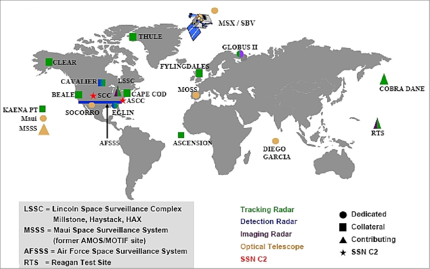
The last few years have demonstrated more than ever the importance of SSA (Space Situational Awareness), or keeping better track on the increasing number of objects orbiting the Earth. Examples including ASAT (Anti Satellite) tests and satellite collisions create thousands of additional debris objects, some of them in long-lived orbits that will pose collision risks to satellites for decades.
Following a recent collision event, the US took additional steps to ramp up their calculations of potential satellite collisions to prevent similar collisions. However, such predictive efforts require frequently-updated observations of satellites and potential debris.
In the context of global space security, Canada started the development its own spaceborne surveillance system in 2007, referred to as CSSS (Canadian Space Surveillance System). The objective of CSSS is to secure timely access to orbital data essential to Canada's sovereignty and national security by contributing to the deep space surveillance mission of the United States Space Surveillance Network (SSN) which maintains a global catalog of orbit elements for Resident Space Objects (RSOs).
The CSSS satellite, called Sapphire, will contribute data to the U.S. SSN (Space Surveillance Network). The minisatellite Sapphire, planned for launch in 2011 into LEO, is expected to complement the SBSS pathfinder spacecraft in monitoring satellites and space debris in GEO.
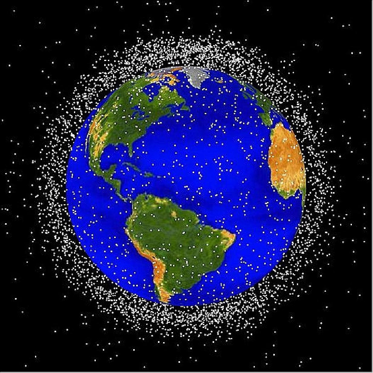
Category | Definition (size of objects) | Estimated population | Potential risk to satellites |
Trackable | > 10 cm in diameter | 19,000 + | Complete destruction |
Potentially trackable | > 1 cm in diameter | Several hundred thousand | Complete to partial destruction |
Untrackable | < 1 cm in diameter | Many millions to billions | Degradation, loss of certain sensors or subsystems |
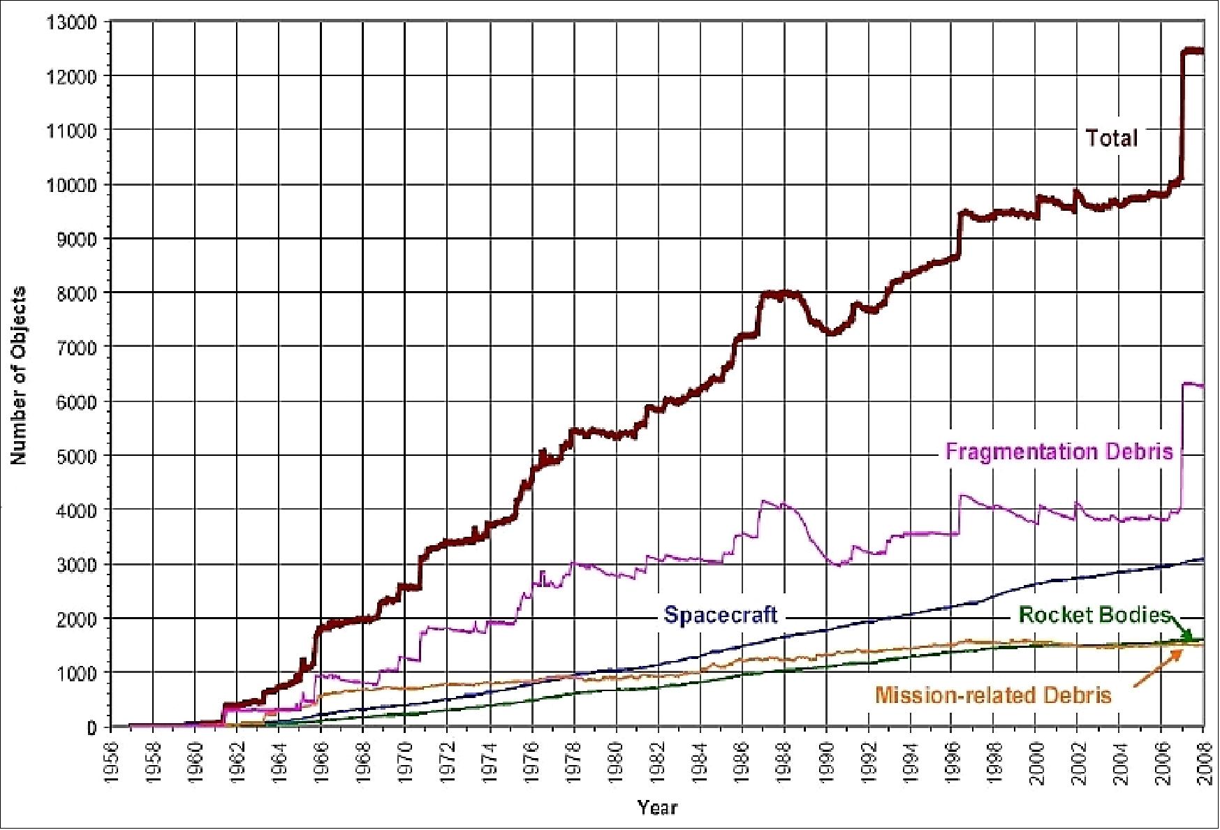
Legend to Figure 3: This chart displays a summary of all objects in Earth orbit officially cataloged by the U.S. Space Surveillance Network. "Fragmentation Debris" includes satellite breakup debris and anomalous event debris, while "Mission‐related Debris" includes all objects dispensed, separated, or released as part of the planned mission. The dramatic increase in fragmentation debris was caused by the Chinese ASAT test conducted in January 2007.
Note: Figure 3 was taken from the following reference which was removed from the web in the meantime: "Orbital Debris Fact Sheet,," Secure World Foundation, April 10, 2008, URL: http://www.secureworldfoundation.org/siteadmin/images/files/file_16.pdf
SBSS-1 Pathfinder Program
In March 2004, Northrop Grumman Mission Systems, the Mission Area Prime Contractor for the Air Force, awarded a Boeing best-of-industry team, including Ball Aerospace and Harris Technologies, the contract to develop and initiate operations of the SBSS-1 Pathfinder satellite.
However, this initial arrangement was deemed as too cumbersome, creating a needless extra management layer between the Air Force and the industry team actually building the hardware. In early 2006, the Air Force and Northrop Grumman arrived at the mutual decision that the company should relinquish its oversight duties back to the Service.
The updated/restructured SBSS-1 contract calls for the Boeing team to develop a satellite, the ground segment, and provide launch services. The team is also responsible for mission planning, mission data processing and operation of the system for up to one year, prior to transitioning it to the Air Force. 11)
The Boeing Company has overall responsibility for the SBSS-1 system and is developing the SBSS ground segment, while working with BATC (Ball Aerospace Technology Corporation) to develop the spacecraft and the SBV (Space Based Visible) Sensor.
AFSPC (Air Force Space Command) | - Operational Tasking and Decision Making | |
SMC (Space and Missile System Center) | Space Superiority Systems | - SBSS System Program Office Management |
First Space Operations Squadron (1SOPS) | - SBSS Satellite Operations | |
| Space & Intelligence Systems (S&IS), El Segundo, CA and Seal Beach, CA | - Prime contractor |
Mission System Operations, Colorado Springs, CO and Chandler, AZ | ||
BATC (Ball Aerospace & Technologies Corp.), Boulder and Bloomfield, CO | - Spacecraft bus and payload | |
Harris IT Services, Melbourne, FL | - Satellite Command and Control Software (OS/COMET) | |
MIT/Lincoln Labs, Boston, MA | - Mission planning software | |
OSC (Orbital Sciences Corporation), | - Minotaur IV Launch Vehicle | |
Spacecraft
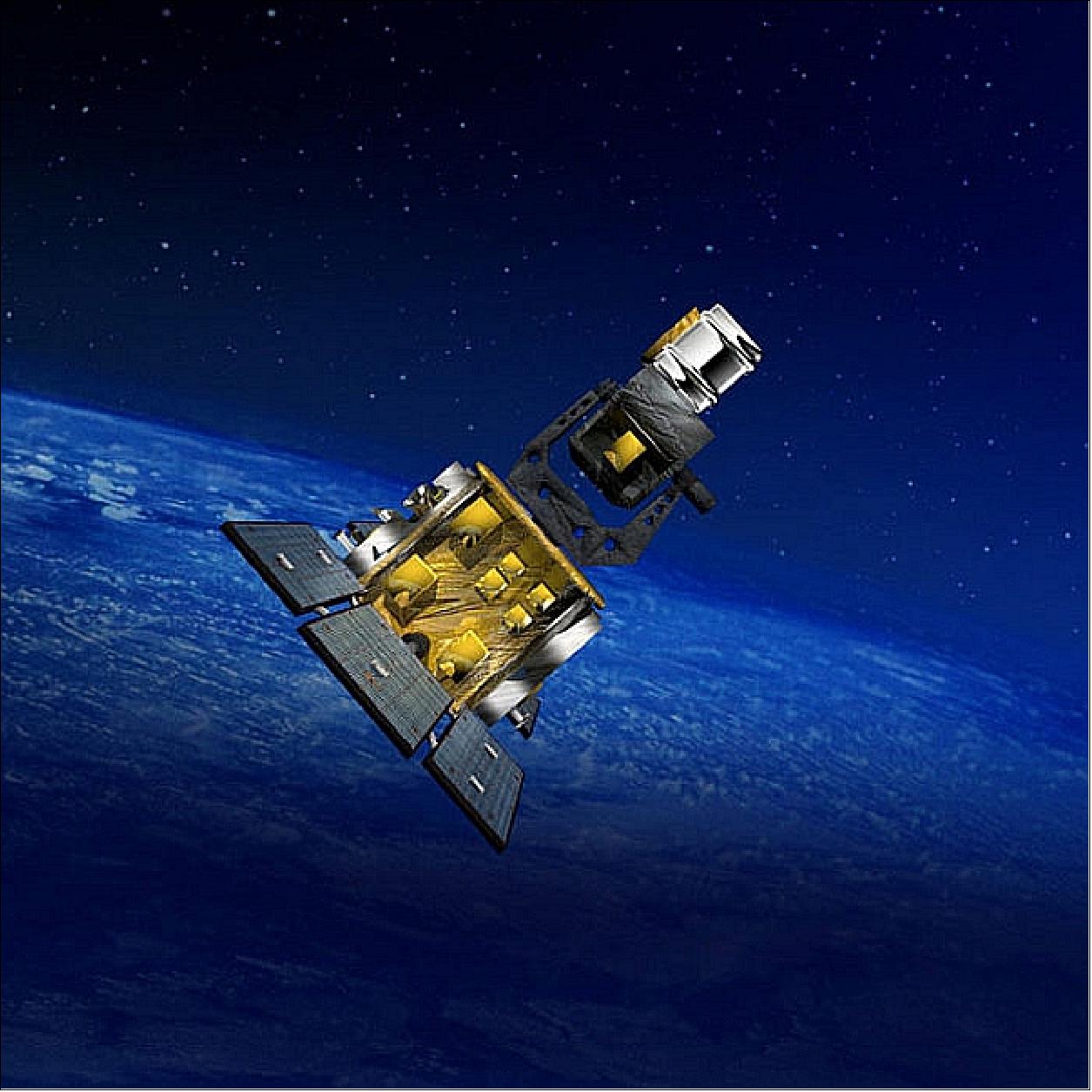
The SBSS-1 spacecraft uses the BCP-2000 (Ball Commercial Platform) bus of BATC. It is 3-axis stabilized featuring the SBV sensor mounted on an agile, two-axis gimbal. The active control is done using a hydrazine thruster system and the sensor components include GPS receivers, 2 star cameras etc. The spacecraft's on-board mission data processor, referred to as OBMDP (On-Board Mission Data Processor), performs image processing to extract moving targets and reference star pixels to reduce the downlink data size. The OBMDP is reprogrammable.
The spacecraft has a launch mass of ~1031 kg with an average power generation of 840 W (EOL). Use of fixed solar arrays with ITJ (Improved Triple Junction) solar cells. The mission design life is 7 years.

RF communications: X-band data transmission of the payload data (up to 320 Mbit/s). The TT&C data are downlinked in S-band and uplinked in L-band.
The SBSS-1 pathfinder system passed the USAF MRR (Mission Readiness Review) in September 2009. On June 1, 2010, the SBSS-1 spacecraft was shipped to VAFB (Vandenberg Air Force Base), CA, after completing a final factory functional checkout.
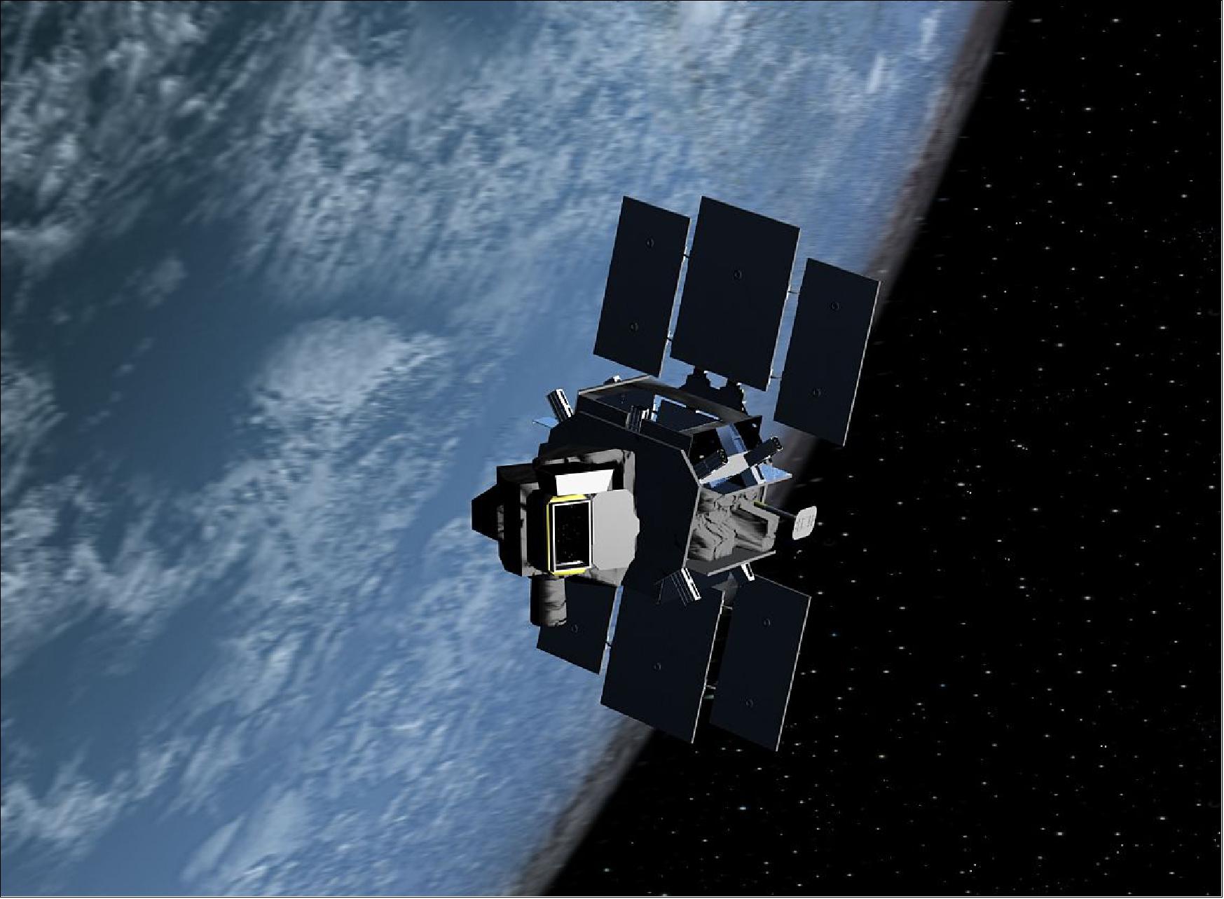
Launch
The SBSS-1 pathfinder spacecraft was launched on September 26, 2010 (UTC) on a Minotaur-4 vehicle of OSC from VAFB, CA, USA. This represented the first orbital launch of the Minotaur-4 vehicle. 13) 14)
The launch had been delayed from 2009 onwards several times mainly due to technical concerns over the Minotaur-4 launch vehicle, in particular the rocket's third stage. It was discovered that the stage's gas generator produced additional thrust, which could have affected missions requiring precise orbital insertion, such as SBSS-1. This concern resulted in a delay to the launch whilst the problem was investigated, and a diffuser was developed to mitigate its effects. This had to be test-flown, which resulted in the suborbital HTV-2a mission being moved up the manifest to fly before SBSS-1 (Ref. 13).
But in August 2010, Air Force officials had completed their assessment and implemented necessary corrective actions associated with a Minotaur-4 rocket software issue. That issue had prompted the Air Force to delay its previously scheduled July 8, 2010 launch of SBSS-1. As the software effort came to a close, the government and industry team identified a potential mission risk associated with certain connectors used on flight avionics components aboard the Minotaur-IV launch vehicle. 15) 16)
Orbit: Sun-synchronous circular orbit on an ascending node, altitude = 630 km, inclination = 98º.
Mission Status
• July 3, 2021: U.S. Space Command announced July 1 it has signed a data-sharing agreement with the Libre Space Foundation, a non-profit that promotes open access to information about space. - The memorandum with Libre Space Foundation is Space Command's 100th commercial space situational awareness data sharing agreement. 17) 18)
- "Space situational awareness, which requires these types of cooperative agreements in order to achieve efficiency and effectiveness, is one of many approaches used to ensure all responsible space-faring nations continue benefitting from this critical domain," the commander of Space Command Gen. James Dickinson, said in a news release.
- Papadeas Pierros, executive director of the Libre Space Foundation, said the organization supports "open data and data sharing as a way to enhance space exploration and space safety." He said the agreement with Space Command "is a step towards achieving safer space operations for all."
- The Libre Space Foundation, based in Greece, was founded in 2015.
- U.S. Space Command said data sharing is increasingly important as space becomes more congested. "Mega constellations are quickly filling the available orbits. Commercial companies are launching 60 or more satellites at a time and China has announced plans to launch more than 13,000 satellites for a new constellation in the coming years," the command said.
- As more countries, companies and organizations deploy satellites, "it is in our collective interest to act responsibly, promote transparency and enhance the long-term sustainability, stability, safety and security of space," Dickinson said. "The best way to do that is to get a picture of what is going on up there."
- The memorandum with the Libre Space Foundation was signed July 1 by U.S. Navy Rear Adm. Michael Bernacchi, Space Command's director of plans, strategy and policy. It marks Space Command's 100th commercial space situational awareness data sharing agreement.
- Space Command has signed space data-sharing agreements with 26 nations, two intergovernmental organizations and three academic institutions that own, operate, launch or provide services to satellite operators.
• November 4, 2019: Rear Adm. Marcus A. Hitchcock, U.S. Space Command plans and policy director, and Maj. Gen. Pasi Jokinen, commander of the Finnish Air Force, signed a Memorandum of Understanding between Finland and the United States on space situational awareness cooperation today in Helsinki, Finland. 19)
- These agreements foster openness, predictability of space operations, and transparency for space domain awareness. The Memorandum of Understanding sets out the intention to exchange public space situational information between Finland and the U.S. to protect against space debris and to reduce various collision risks.
- Finland joins a long list of nations, agencies and commercial entities that recognize unfettered access to and freedom to operate in space advances the security, economic prosperity and scientific knowledge of the nations who share the commitment. Australia, Japan, Italy, Canada, Finland, France, South Korea, the United Kingdom, Germany, Israel, Spain, the United Arab Emirates, Belgium, Norway, Denmark, Brazil, the Netherlands, Thailand, New Zealand, Poland and Romania; two intergovernmental organizations, the European Space Agency and the European Organization for the Exploitation of Meteorological Satellites; and 80 commercial satellite owner/operator/launchers now participate in SSA data-sharing agreements.
- "Space Situational Awareness requires extensive collaboration, and agreements such as this allow us to partner more effectively," Hitchcock said. "As more countries field space capabilities and benefit from the use of space systems, it is in our collective interest to act responsibly, promote transparency and enhance the long-term sustainability, stability, safety and security of the domain."
- "The way we defend and protect our way of life is to build alliances and partnerships with countries who also embrace the shared goal of continued peaceful use of space," Hitchcock continued. "Our international partners have contributed to SSA and have aided our ability to communicate across the globe for years. These strong international alliances and partnerships create opportunity to demonstrate the peaceful use of space while sharing and disaggregating the U.S. space capability."
- The U.S. seeks to expand international cooperation, strengthen stability and international partnerships in space in accordance with the National Space Policy.
- "The continuous growth of both governmental and commercial spaceflight emphasizes the significance of accurate and up-to-date situational awareness," Jokinen said. "As the United States is a global leader in Space Situational Awareness, this Memorandum of Understanding will help us to enhance our capabilities."
- In Finland, the Air Force cooperates with civilian agencies such as the Finnish Meteorological Institute and the Finnish Geospatial Research Institute in order to create and develop national space situational capabilities.
- Upon establishment, USSPACECOM assumed the responsibility for signing SSA agreements on behalf of the U.S. government with governmental agencies and commercial satellite owners and operators to provide space information such as conjunction assessment, launches, deorbits and reentry assistance.
- Effective SSA requires cooperation – we cannot do it alone. We are working with our partners and allies to enhance SSA data sharing, cooperation and partnerships, while listening and responding to the security concerns and requirements of our partners and allies.
- USSPACECOM was officially established Aug. 29, 2019, during a ceremony at the White House as a geographic command with a designated Area of Responsibility defined as 100 kilometers above mean sea level.
• December 14, 2017: The Boeing Co. has been awarded a modified contract from the U.S. Air Force for sustainment of the spaceborne space surveillance Block 10 satellite. 20)
- The deal, announced on Dec. 13 by the Department of Defense and worth more than $21.9 million under the terms of the contract, is classified as a cost-plus-incentive-fee and cost-plus-fixed-fee contract.
- The SBSS (Space Based Space Surveillance) Block 10 satellite operates 24-hours a day, 7-days a week with a clear and unobstructed view of objects orbiting Earth.
- The SBSS is used to "collect metric and Space Object Identification data for man-made orbiting objects without the disruption of weather, time of day and atmosphere that can limit ground-based systems."
- Work on the contract will be performed in California and Colorado, and is expected to be completed by June 2022.
• SSA (Space Situational Awareness) data-sharing agreements with USSTRATCOM: In April 2017, Norway joined 12 nations [the United Kingdom, South Korea, France, Canada, Italy, Japan, Israel, Spain, Germany, Australia, the United Arab Emirates and Belgium), two intergovernmental organizations (ESA (European Space Agency) and EUMETSAT (European Organization for the Exploitation of Meteorological Satellites)] and more than 60 commercial satellite owner/operator/launchers already participating in SSA data-sharing agreements with USSTRATCOM. 21)
- SSA data-sharing agreements enhance multinational space cooperation and streamline the process for USSTRATCOM partners to request specific information gathered by USSTRATCOM's JSpOC (Joint Space Operations Center) at Vandenberg Air Force Base in California. The information is crucial for launch support, satellite maneuver planning, support for on-orbit anomalies, electromagnetic interference reporting and investigation, satellite decommissioning activities and on-orbit conjunction assessments.
• August 2, 2016: The USAF (United States Air Force) plans to launch a next-generation SBSS (Space-Based Space Surveillance) system in 2021. The SBSS will be used to track space objects, primarily satellites, in geosynchronous orbit. Located some 36,000 km above the equator, the area is densely-populated, with fierce competition for satellite placement. 22)
- The SBSS-1 pathfinder satellite (also referred to as Block 10 pathfinder), the first satellite in the series, was launched in 2010. It is fully operational. It was initially planned to function for 7 years, but its lifetime has been extended to 2020, when a constellation of three next-generation satellites are set to be placed in orbit.
- The follow-on SBSS mission might also consider the concept of hosted surveillance payloads on commercial satellites. 23)
Information on existing USAF GSSAP assets for SSA services 24) 25)
Next to the SBSS-1 pathfinder mission, the USAF (United States Air Force) operates and maintains a constellation of four GSSAP (Geosynchronous Space Situational Awareness Program) satellites with the ability to monitor and inspect disabled U.S. satellites from above and below.
1) The AFSPC-4 (U.S. Air Force Space Program Command-4) mission was launched on July 28, 2014, which successfully deployed the first two GSSAP satellites. Following over a year of testing, the first pair of spacecraft were declared operational in September 2015. - The AFSPC-4 has already been used to provide detailed imagery of the ailing MUOS-5 military SatCom to give the Pentagon unspecified clues about salvaging that mission.
2) On August 19, 2016, the ULA Delta-4 vehicle launched successfully the AFSPC-6 mission from Cape Canaveral, which deployed a second pair of satellites for GSSAP into near-geosynchronous orbits.
According to GlobalSecurity.org, the GSSAP satellites are part of the U.S.'s future SBSS ( Space Based Space Surveillance) system that will be formed by a whole constellation of satellites and ground facilities to enable the U.S. to image and track other satellites in geosynchronous orbit. The GSSAP satellites have the capability to perform RPO (Rendezvous and Proximity Operations). RPO allows for the space vehicle to maneuver near a resident space object of interest, enabling characterization for anomaly resolution and enhanced surveillance, while maintaining flight safety. 25) — GSSAP was aimed at possible space conflicts, when some nation might try to shoot down or disable American military satellites that form the backbone of US intelligence, missile targeting and communication capabilities.
• In March 2016, SBSS reached its mean mission life of 5.5 years. The spacecraft is still performing at optimal levels and will continue to provide critical space situational data into the future. SBSS makes an average of 15,000 observations per day. 26)
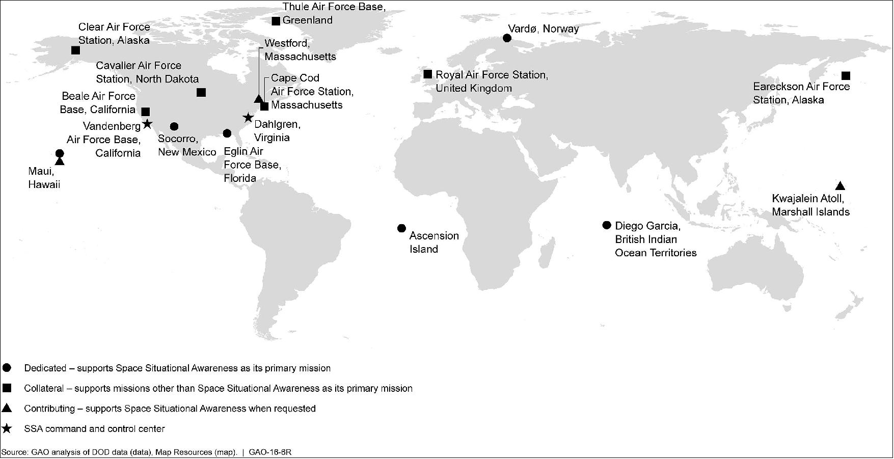
• October 2015: SSA (Space Situational Awareness) data is obtained and processed using a variety of sensors and systems—satellites, ground-based radars, and optical telescopes. According to DoD, a potential of 375 sensors and systems are available to contribute to SSA across the commercial, civil, military, and intelligence communities. Currently, the primary sensors used are a core group of 8 dedicated and 18 multiple mission sensors. While DoD provides most of these sensors and systems, other entities—such as NASA, NOAA, the intelligence community, and commercial companies—also provide data used for SSA. For much of the core group of sensors, DOD is leveraging assets by using sensors that perform other missions as their primary functions, such as sensors used for missile defense and missile warning. The U.S. JSpOC (Strategic Command's Joint Space Operations Center) is responsible for analyzing the data provided by the sensors and processing it into useable SSA information. For example, in 2014 JSpOC provided 671,727 collision warnings to satellite operators to alert them of a potential need to move their satellites to avoid a collision with another space object. 27)
Overview of DoD SSA program efforts in 2015 27) 28)
Five new sensor systems are planned or in development to enhance SSA data collection:
• ORS-5 (Operationally Responsive Space-5). The ORS-5 satellite (also known as SensorSat) is to provide data on space objects as far as the geosynchronous belt; the CDR (Critical Design Review) is planned for September 2015, a launch is expected in mid-2017. The satellite will bridge a potential gap in surveillance of geosynchronous orbit currently provided by the SBSS-1 mission. In addition, the ORS-5 mission will act as a pathfinder for technologies to be used in a follow-on to the current SBSS-1 mission.
• Space Fence — Ground-based radars to detect and track objects in low and medium Earth orbit; first radar expected to be operational in 2019.
• SBSS (Space Based Space Surveillance) Follow On—Satellite system to provide data on space objects as far as the geosynchronous belt; request for proposals expected May 2016 and launch targeted for fiscal year 2021.
• WSF (Weather Systems Follow-on). The ECP ( Energetic Charged Particle) sensor on WSF satellite is to provide space weather data for SSA; WSF ECP prototypes delivery expected in fiscal year 2018.
• NEXION (Next Generation Ionosonde): NEXION features ground-based radars to provide data on the particles that make up the ionosphere for SSA and other space weather analyses; installations underway and expected complete in fiscal year 2022.
• On Sept. 26, 2015, the SBSS-1 spacecraft was 5 years on orbit continuing its contribution to the Space Surveillance Network.
• Feb. 25, 2015: The SBSS-1 satellite operates 24-hours a day, 7-days a week collecting metric and Space Object Identification data for man-made orbiting objects without the disruption of weather, time of day and atmosphere that can limit ground-based systems. SBSS has a clear and unobstructed view of resident space objects orbiting Earth from its 630 km altitude orbit. 29)
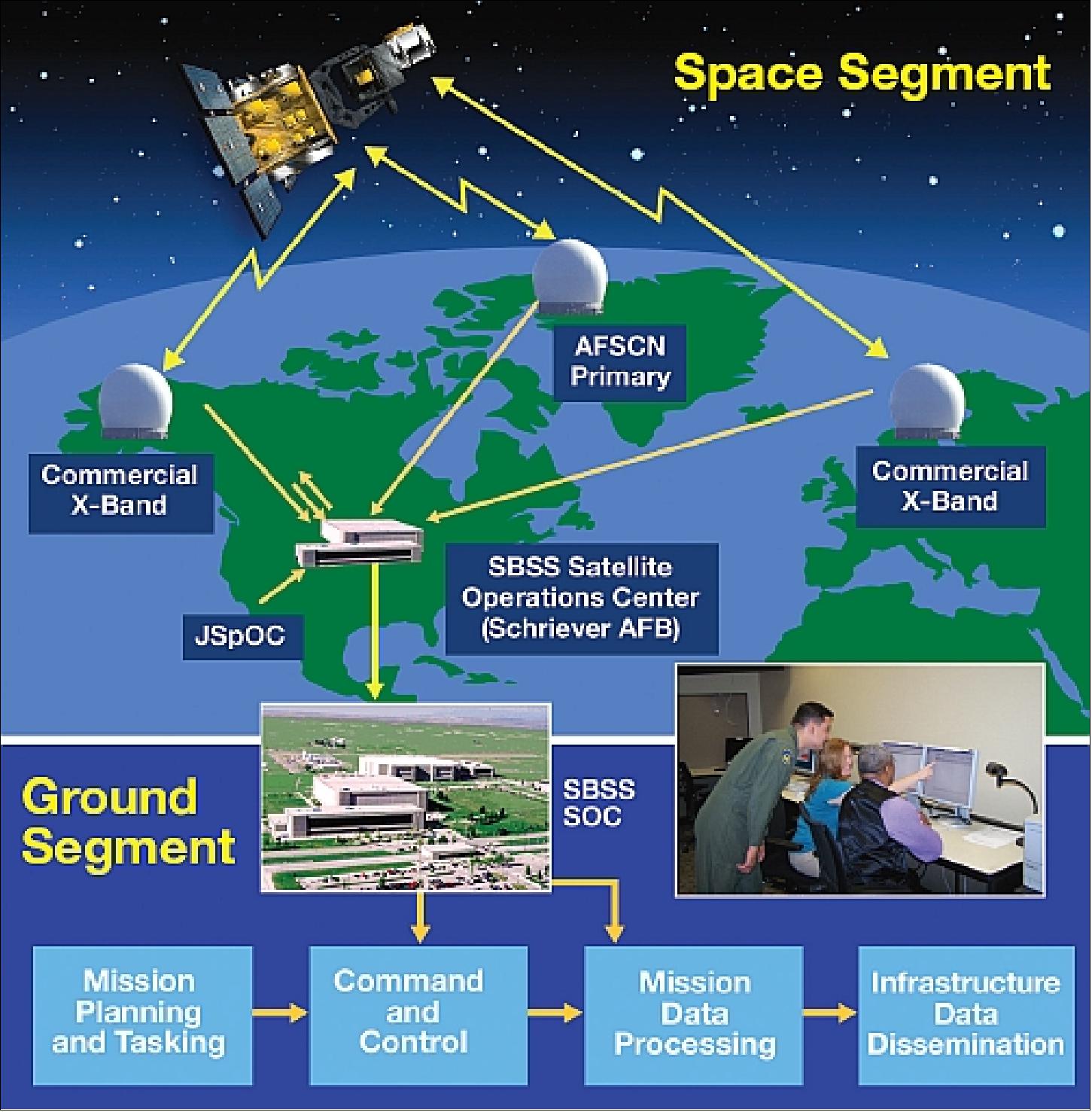
- SBSS communicates information through the world-wide Air Force Satellite Control Network and commercial USN (Unified Space Network) ground stations and then to Schriever Air Force Base where operators oversee the day-to-day command and control operations of SBSS. This satellite system can monitor objects as small as a 1 m cube all the way out to the Geosynchronous belt at 35, 786 km from Earth. SBSS provides the data necessary to predict the trajectories of these objects, which gives experts an idea if an orbiting satellite may collide with another orbiting object, which allows time for evasive action to be taken in order to avoid collisions.
• October 2014: The 1st SOPS (Space Operations Squadron) of the USAF commemorated the 4th anniversary of the SBSS on-orbit operations. The SOPS has commanded and controlled SBSS since it reached orbit in September 2010, it also gained a new space situational awareness system, the GSSAP (Geosynchronous Space Situational Awareness Program), this past summer. In June 2014, Air Force Space Command leaders directed the 1st SOPS to add command and control of GSSAP to its portfolio of situational awareness systems, which includes the SBSS and ATRR (Advanced Technology Risk Reduction) satellite. 30)
- SBSS plays a large and significant role in the space situational awareness realm. It uses a two-axis, gimballed optical telescope to provide coverage of satellites and other objects in the geostationary belt. It is one of the few satellites on orbit that look out toward the heavens instead of toward Earth. The SBSS is a LEO (Low Earth Orbit) sensor that provides all-weather, 24-hour space situational awareness data to assist commanders throughout the military in detecting, identifying and tracking potential hazards in space. In essence, the SBSS helps provide a better understanding of the space environment.
- The vehicle performs more GEO observations than any other sensor. It also performs a significant number of deep space observations beyond the GEO belt.
- Built by Boeing Space and Intelligence Systems of El Segundo, CA, the SBSS Block 10 satellite is part of a space situational awareness architecture that also includes ground-based radar and optical sensors. Ball Aerospace & Technologies Corp. of Boulder, Colorado, was a major subcontractor on the SBSS satellite.
• January 2014: The Air Force declared SBSS-1 fully operational in April 2013. The service's data show that during the system's first year of operation, it collected more than 3.8 million observations of objects in deep space. SBSS-1 has a unique ability to swiftly move its onboard sensor, enabling it to observe multiple deep space objects across a broad range, in contrast to the narrow range used by ground-based sensors. 31) 32)
- The SBSS-1 system has helped the U.S. Air Force cut the danger of satellites being lost by two-thirds in the past year by detecting potential threats more quickly and enabling operators to take earlier action if needed.
- Averaging 12,000 deep-space observations per day, SBSS-1 provides a major advantage to satellite operators who need to protect these valuable space assets that we depend on every day. This capability results in a fivefold increase in observations and an estimated reduction in satellite loss of 66%, based on data from capabilities available prior to SBSS's deployment.
• SBSS-1 is operating continuously in 2013. SBSS-1, along with the Advanced Technology Risk Reduction (ATRR) satellite transferred to AFSPC control from the Missile Defense Agency in 2011, are the nation's only space-based systems supporting U.S. Strategic Command's space surveillance operations. 33)
• SBSS-1 reached a significant milestone in August 2012 with its IOC (Initial Operational Capability). 34) 35)
• The SBSS-1 spacecraft is operational in the spring of 2011, supplementing the ground-based tracking network.
• On Feb. 23, 2011, SMC (Space and Missile Systems Center) handed over control of the SBSS-1 system to the 1st Space Operations Squadron (1 SOPS) at Schriever AFB - signaling the start of the satellite's operational duty. Compared to ground-based tools, SBSS-1 provides an increase of SSA (Space Situational Awareness) by a factor of three. 36)
• On-orbit testing of SBSS-1 was completed on December 23, 2010. 37)
• The MMSOC (Multi-Mission Spacecraft Operations Center) at Schriever AFB (near Colorado Springs, CO, USA) has acquired first signals of the SBSS-1 spacecraft after orbit insertion. Shortly after launch, SBSS-1 began an automated sequence that deployed solar arrays, pointed them at the sun, and initialized satellite operations. 38)
Sensor Complement
The SBSS-1 payload is comprised of a visible sensor assembly, a gimbal, and payload deck electronics.
SBV (Space Based Visible)
The SBV imager features a telescope of 30 cm aperture, mounted on a two-axis gimbal and equipped with a 2.4 megapixel detector. The gimbal gives the telescope a very wide FOV (Field of View) of 3π steradians, or three-quarters of the entire sky. An on-board calibration subsystem is used. The SBV imager on SBSS-1 will have over twice the sensitivity and ten times the capacity of SBV on MSX. 39)
The activity in SSA is to maintain a catalog of objects on orbit to realtime awareness of what is happening on orbit. One objective of the SVB imager in LEO is to observe and track once a day in particular the object/spacecraft configurations in the rather crowded geostationary orbit (GEO).
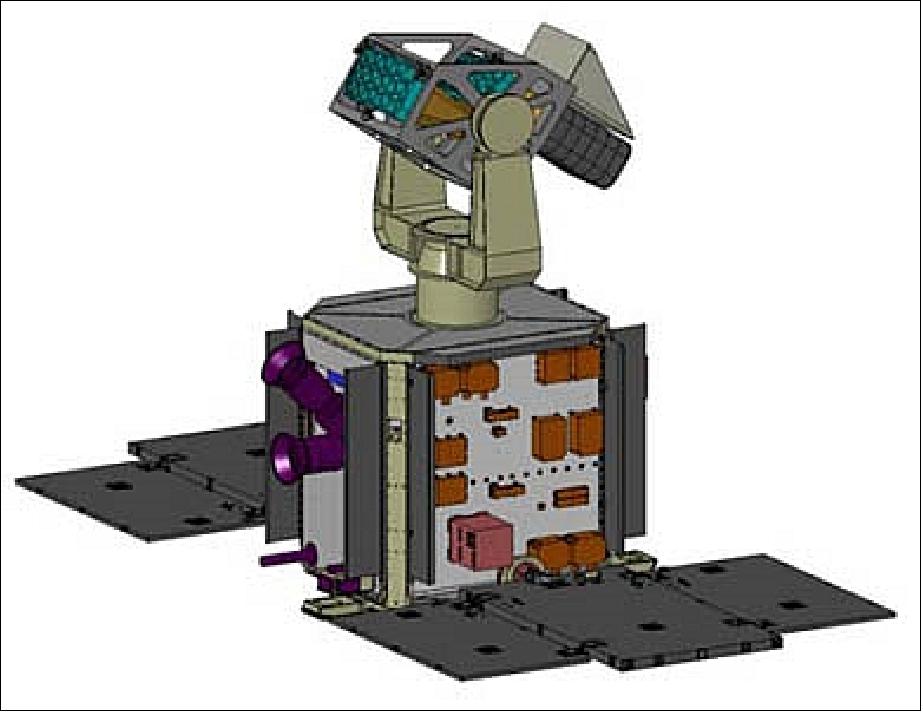
The SBV assembly consists of the following elements: 40)
- Optical bench
- Telescope (30 cm diameter). A TMA (Three Mirror Anastigmatic) telescope is used.
- CCD FPA (Focal Plane Array)
- Cryo radiator for passive payload cooling
- VIB (Video Interface Box)
- Elevation electronics box
- Filter wheel mechanism
- Focus mechanism
- Aperture door mechanism
- Electrical harness.
The gimbal consists of the following elements:
- Beryllium yoke
- Azimuth and elevation drives
- Azimuth launch lock
- Electrical harness for interface with payload electronics.
The payload deck electronics package consists of:
- Payload electronics box
- Gimbal amplifier segment
- Solid state recorder
- Electrical harness for interface with visible sensor assembly, gimbal, and bus.
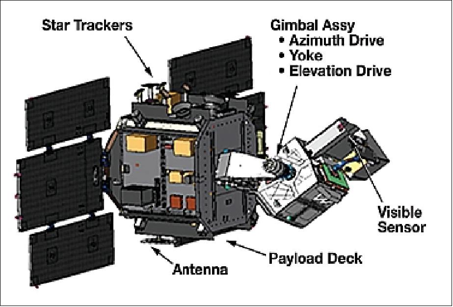
Note: The military involvement in the SBSS program classifies the information available to the general public, making it virtually impossible for an outsider to come up with a proper technical description of the spacecraft and its subsystems as well as of the sensor complement.
Ground Segment
An open highly redundant ground system architecture was implemented to be able to respond quickly to the changing mission requirements and to upgrade functionality when needed.
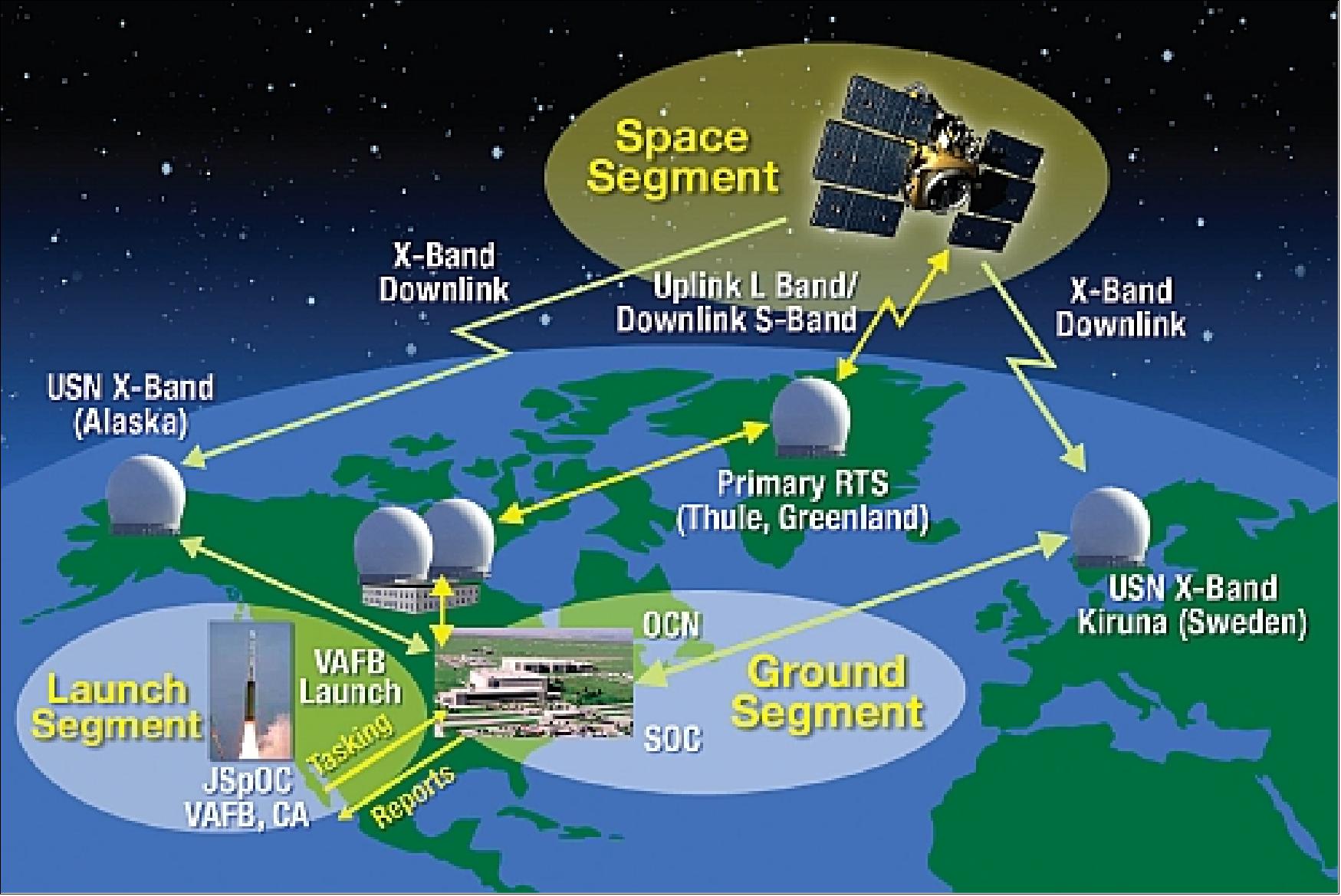
• The AFSCN (Air Force Satellite Control Network) TTS (Thule Tracking Station) at the Thule AFB (76º 32' northern latitude, 68º 50' western longitude)), Thule, Greenland is the primary station for SBSS operations.
• Further ground stations are the USN (Universal Space Network) commercial facilities near Fairbanks, Alaska (65.1º 48' northern latitude, and 147º 4' western longitude), and at ESRANGE (67º 53' northern latitude, 21º 04' eastern longitude) near Kiruna, Sweden.
• The MMSOC (Multi-Mission Spacecraft Operations Center) is located at Schriever Air Force Base near Colorado Springs, CO. The SOPS (1st Space Operations Squadron) operates and maintains the command and control capability for the SBSS-1 spacecraft.
• The JSpOC (Joint Space Operations Center) at Schriever AFB uses the SBSS-1 data for SSA (Space Situational Awareness) warnings of military space assets. 42)
SBSS-1 will operate in conjunction with the SSN (Space Surveillance Network) to support spaceflight safety, ensure space catalog completeness, warn of on-orbit separations and maneuvers, and provide indications and warnings of potentially hostile space events.
References
1) "Space Based Space Surveillance (SBSS)," Global Security, July 21, 2011, URL: http://www.globalsecurity.org/space/systems/sbss.htm
2) "Space Situational Awareness," URL: http://www.cpi.com/capabilities/ssa.html
3) Gene H. McCall, "Space Surveillance," URL: http://www.fas.org/spp/military/program/track/mccall.pdf
4) "United States Space Surveillance Network," Wikipedia, URL: http://en.wikipedia.org/wiki/United_States_Space_Surveillance_Network
5) David A. Vallado, Jacob D. Griesbach, "Simulating Space Surveillance Networks," AAS/AIAA Astrodynamics Specialist Conference, July 31 ‐ August 4, 2011, Girdwood, Alaska, paper: AAS 11-580,URL: [web source no longer available]
6) Glen Shepherd, "Space Surveillance Network," AFSPC (Air Force Space Command), URL: http://rezn8d.com/gallery/ssa2shepherd.pdf
7) Jayant Sharma, Grant H. Stokes, Curt von Braun, George Zollinger, Andrew J. Wiseman, "Toward Operational Space-Based Space Surveillance," Lincoln Laboratory Journal, Vol. 13, No 2, 2002, URL: http://citeseerx.ist.psu.edu/viewdoc/download?doi=10.1.1.66.6626&rep=rep1&type=pdf
8) Jeff Foust, "A new eye in the sky to keep an eye on the sky," The Space Review, May 10, 2010, URL: http://www.thespacereview.com/article/1622/1
9) http://orbitaldebris.jsc.nasa.gov/photogallery/beehives.html#leo
10) Brian Weeden, "The numbers game," The Space Review, July 13, 2009, URL: http://www.thespacereview.com/article/1417/1
11) "Space Based Space Surveillance - Enhancing the Nation's Space Situational Awareness," URL: http://www.boeing.com/defense-space/space/satellite/SSBS_Product_Card.pdf
12) http://www.ballaerospace.com/page.jsp?page=234
13) William Graham, "Minotaur IV launches first Space Based Space Surveillance satellite," Sept. 25, 2010, URL: http://www.nasaspaceflight.com/2010/09/live-minotaur-first-space-based-space-surveillance-satellite/
14) "Minotaur IV/SBSS," Orbital, Sept. 2010, URL: http://www.orbital.com/NewsInfo/MissionUpdates/MinotaurIV_SBSS/index.shtml
15) Amy Klamper, "Minotaur 4 Concerns Delay Launch of Space-Based Space Surveillance Sat," Space News, Oct. 6, 2009, URL: http://www.spacenews.com/launch/sbss-launch-pushed-into-2010.html
16) "Air Force SBSS Launch Postponed," Satellite Today, July 8, 2010, URL: http://www.satellitetoday.com/st/headlines/Air-Force-SBSS-Launch-Postponed_34517.html
17) Sandra Erwin, "U.S. Space Command signs data-sharing agreement with Libre Space Foundation," SpaceNews, 3 July 2021, URL: https://spacenews.com/u-s-space-command-signs-data-sharing-agreement-with-libre-space-foundation/
18) "USSPACECOM signs 100th commercial agreement to share space data, service," Spacecom News, 1July 2021, URL: https://www.spacecom.mil/Newsroom/News/Article-Display/Article/2680576/usspacecom-signs-100th-commercial-agreement-to-share-space-data-service/
19) "USSPACECOM, Finnish Air Force sign Memorandum of Understanding between Finland, US on space situational awareness cooperation," USSC News, 4 November 2019, URL: https://www.spacecom.mil/Newsroom/News/Article-Display/Article/2007988/usspacecom-finnish-air-force-sign-memorandum-of-understanding-between-finland-u/
20) "Boeing tapped to sustain Space-Based Space Surveillance system," Space Daily, 14 Dec. 2017, URL: http://www.spacedaily.com/reports/Boeing_tapped_to_
sustain_Space-Based_Space_Surveillance_system_999.html
21) "US Strategic Command, Norway sign agreement to share space services, data," U.S. Strategic Command, April 5, 2017, URL: http://www.stratcom.mil/Media/News/News-Article-View/
Article/1142970/us-strategic-command-norway-sign-agreement-to-share-space-services-data/
22) "US Air Force to Introduce Space Based Surveillance System in 2021," Space Daily, August 2, 2016, URL: http://www.spacedaily.com/reports/US_Air_Force_to_Introduce_
Space_Based_Surveillance_System_in_2021_999.html
23) Mike Gruss, "U.S. Air Force's next space surveillance system on target for 2021," Space News, July 25, 2016, URL: http://spacenews.com/u-s-air-forces-next-space-surveillance-system-on-target-for-2021/
24) Craig Covault, "AFSPC-6 Launch Helps Form Extraordinary New US Space Defense Foundation," AmericaSpace, Aug. 19, 2016, URL: http://www.americaspace.com/?p=94896
25) "Geosynchronous Space Situational Awareness Program (GSSAP)," URL: http://www.globalsecurity.org/space/systems/gssap.htm
26) "Space based Space Survaillance," BATC, March 2016, URL: http://www.ball.com/aerospace/Aerospace/media/Aerospace/Downloads/D1910__SBSS_0416.pdf?ext=.pdf
27) Cristina T. Chaplain, "Space Situational Awareness: Status of Efforts and Planned Budgets," GAO (Government Accountability Office), Oct. 8, 2015, URL: http://www.gao.gov/assets/680/672987.pdf
28) Thomas M. Davis, "Operationally Responsive Space – The Way Forward," Proceedings of the 29th Annual AIAA/USU Conference on Small Satellites, Logan, Utah, USA, August 8-13, 2015, paper: SSC15-VII-4, URL: http://digitalcommons.usu.edu/cgi/
viewcontent.cgi?article=3213&context=smallsat
29) "Space Based Space Surveillance (SBSS)," Air Force Space Command, Feb. 25, 2015, URL: https://web.archive.org/web/20150919125725/http://www.afspc.af.mil/library/factsheets/factsheet.asp?id=20523
30) "Four Years Of Space Surveillance For U.S.A.F.'s SBSS," Satnews Daily, October 25, 2014, URL: http://www.satnews.com/story.php?number=1464679438
31) "Boeing Space Surveillance System Reduces Risk of Satellite Loss by 66 Percent," Boeing New Release, Jan. 14, 2014, URL: http://boeing.mediaroom.com/index.php?s=20295&item=128939
32) "Boeing Space Surveillance System Reduces Risk of Satellite Loss by 66 Percent," Space Daily, Jan. 17, 2014, URL: http://www.spacedaily.com/reports/Boeing_Space_Surveillance
_System_Reduces_Risk_of_Satellite_Loss_by_66_Percent_999.html
33) "Space Based Space Surveillance (SBSS)," Air Force Space Command, March 26, 2013, URL: https://web.archive.org/web/20150919125725/http://www.afspc.af.mil/library/factsheets/factsheet.asp?id=20523
34) "Space Based Space Surveillance Makes Headway [SBSS]," Defense Industry Daily, August 21, 2012, URL: http://www.defenseindustrydaily.com/preventing-a-space
-pearl-harbor-sbss-program-to-monitor-the-heavens-06106/
35) "Space-Based Space Surveillance (SBSS) Block 10," URL: http://www.dote.osd.mil/pub/reports/FY2011/pdf/af/2011sbss.pdf
36) Scott Prater, "SSA enhanced thanks to new 1 SOPS mission," Schriever Sentinel, Vol. 5 No. 9, March 3, 2011, URL: http://csmng.com/wp-files/schriever-sentinel-weekly-pdfs/sentinel_2011-03-03.pdf
37) "Space Based Space Surveillance (SBSS) System," Boeing Defense, Space & Security, March 2011, URL: http://www.boeing.com/defense-space/space/satellite/bkgd_sbss_0311.pdf
38) "First Boeing SBSS Satellite Sends Initial Signals From Space," Space Daily, Sept. 27, 2010, URL: http://www.spacedaily.com/reports/First_Boeing_SBSS_Satellite_Sends_Initial_Signals_From_Space_999.html
39) Grant H. Stokes, Curt von Braun, Ramaswamy Sridharan, David Harrison, Jayant Sharma, "The Space-Based Visible Program," Lincoln Laboratory Journal, Vol. 11, No 2, 1998, pp. 205-238, URL: http://citeseerx.ist.psu.edu/viewdoc/download?doi=10.1.1.70.8068&rep=rep1&type=pdf
40) Richard F. Colarco, "Space Surveillance Network Sensor Development, Modification, and Sustainment Programs," URL: http://www.amostech.com/TechnicalPapers/2009/Space_Situational_Awareness/Colarco.pdf
41) "Space Based Space Surveillance," Mission Brochure, Boeing Company, URL: http://www.boeing.com/defense-space/space/satellite/MissionBook.pdf
42) Erin Flynn Jay, "Increasing Space Situational Awareness," MSMF (Military Space & Missile Forum), Vol. 2, Issue 6, 2009, URL: http://www.militaryphotos.net/forums/showthread.php?172692-Increasing-Space-Situational-Awareness
The information compiled and edited in this article was provided by Herbert J. Kramer from his documentation of: "Observation of the Earth and Its Environment: Survey of Missions and Sensors" (Springer Verlag) as well as many other sources after the publication of the 4th edition in 2002. - Comments and corrections to this article are always welcome for further updates (eoportal@symbios.space).
Spacecraft Launch Mission Status Sensor Complement Ground Segment References Back to top