Xona Space Systems
Non-EO
Position and Navigation
Quick facts
Overview
| Mission type | Non-EO |
| Launch date | 25 May 2022 |
Xona Space Systems develops a private GNSS (Global Navigation Satellite System)
Development Status References
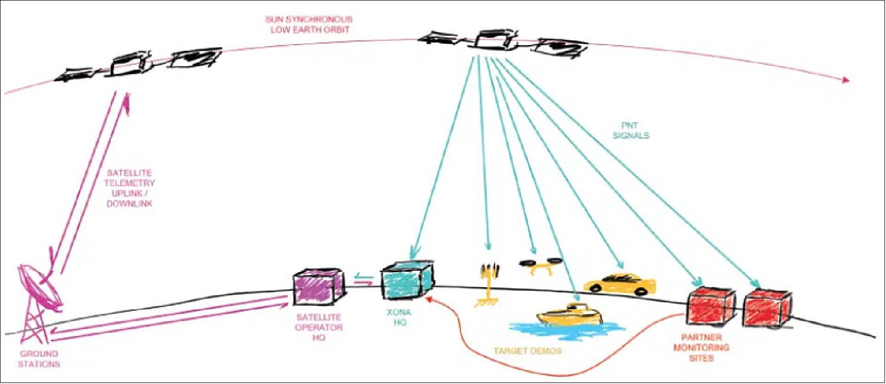
May 10, 2022: Xona Space Systems , the aerospace startup of San Mateo, CA, developing a precision navigation and timing system in LEO (Low Earth Orbit), today announced that their first in-space demonstrator has been delivered to Spaceflight Inc. for final integration after successfully completing testing and is scheduled for launch on SpaceX's Transporter-5 in May. Xona is building the first ever independent high-performance satellite navigation and timing system designed to meet the needs of intelligent systems. 1)
Some background on Xona — the new space commercial LEO PNT (Positioning, Navigation and Timing) 2)
The approach to commercial LEO PNT is being taken by Xona Space Systems. Xona, now a VC-backed startup, was founded in 2019 around the idea that modern technology has the potential to benefit people in all walks of life, but to do so it needs to operate safely in any conditions, anywhere on Earth. To enable this, Xona is working to provide resilient and accurate PNT services: satellite navigation for the age of autonomy. 3). Xona is challenging the assumption that the GNSS space segment is fixed and out of reach of commercial entities.
Xona was founded by a group of eight who first met more than a decade ago in Stanford University’s Aero Astro Department. After graduation, some went on to work in the aerospace industry at the likes of SpaceX, Blue Origin and Maxar, while others pursued further graduate studies in the GPS Research Lab. Reuniting in 2019, Xona is now headquartered in San Mateo, California, with additional offices in Vancouver, Canada, and London, UK.
Now a global team of 30, Xona is gearing up to launch its first demonstration LEO PNT missions. Named Huginn and Muninn, this pair sets out to demonstrate high quality commercial PNT LEO signals from a payload suitable for small satellite deployment. In Norse mythology, Huginn (meaning thought) and Muninn (meaning memory) were the Ravens of the God Odin who would fly around the earth every day to bring information back to Odin. Huginn and Muninn are pathfinders for Xona, circling the globe and returning to Xona’s offices with new navigation information every day. The first, Huginn, is scheduled for launch in May on SpaceX’s Transporter-5.
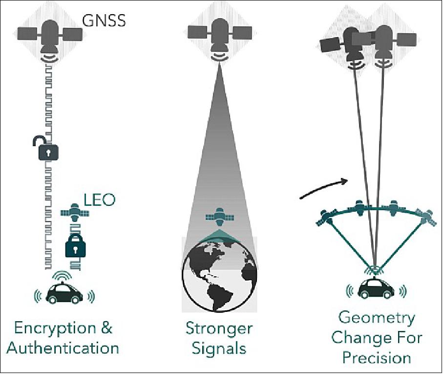
Huginn will broadcast navigation signals in L-band and C-band, providing ranging and navigation data, including corrections for GNSS. It is expected that the rapid geometry change from even just one spacecraft in LEO can greatly accelerate the convergence of GNSS PPP, (Precise Point Positioning) cutting convergence time in half or more.
With more LEO satellites in view, convergence time is expected to improve by fivefold or more without the need for local infrastructure for rapid PPP convergence, bringing forth a solution that is truly global. These experimental PNT signals will also offer security to mitigate the threat of spoofing, using NIST standardized Advanced Encryption Standard (AES) algorithms and Elliptic Curve Digital Signature Algorithm (ECDSA) for code and data authentication. Huginn is software re-programmable, offering a flexible payload on orbit, enabling Xona to test additional advanced capabilities as well.
A signal Interface Control Document (ICD) has been created for the demonstration mission that describes the signals, modulation and data structures in more detail and is available upon request. This has been shared with several partners to aid in prototype receiver development.
Looking Forward
The Huginn and Muninn demonstration missions are the first step toward deployment of Pulsar, Xona’s commercial PNT service. In its ultimate form, this embodies a LEO constellation of several hundred satellites, delivering GPS-level satellite visibility and geometry and full PNT services that are precise and secure. This brings together high accuracy and resilience at the level needed to support applications like self-driving vehicles.
To deploy the service, a phased roll out plan has been devised with different levels of service planned along the way. Phase 1 is deployment of ~40 satellites, which offers a 1-in-view GNSS enhancement service over population centers (mid latitudes). This brings GNSS correction services coupled with LEO geometry change for rapid PPP convergence to centimeter positioning. This adds an additional ranging signal from a fifth constellation that is resilient and secure. Furthermore, it enables time transfer for stationary users, supporting critical infrastructure.
Phase 2 expands the constellation to ~70 satellites, which offers the same service as Phase 1, globally. This fills in gaps over the poles and bolsters satellite numbers over mid-latitudes. These are steppingstones toward the Phase 3 deployment of several hundred satellites, which brings full positioning services online that are precise and secure.
About Pulsar™: Xona’s Pulsar™ precision LEO PNT (Positioning, Navigation and Timing) service leverages the recent advances in small satellite technology to provide users with a secure and robust alternative to traditional GNSS. Xona’s patent pending system architecture utilizes the efficiency of small satellites to provide an affordable global system with more than 10x better accuracy and 100x better interference mitigation than legacy systems. Pulsar™ is the first ever independent high-performance satellite navigation and timing system designed to meet the needs of intelligent systems.
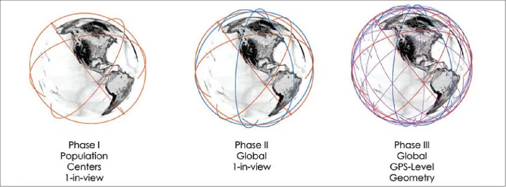
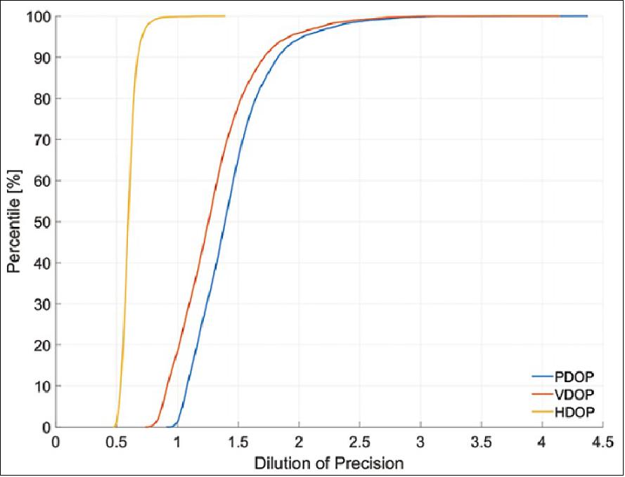
Figure 3 shows a global map of the expected satellite visibility for terrestrial users of the Phase 3 Xona Pulsar constellation.
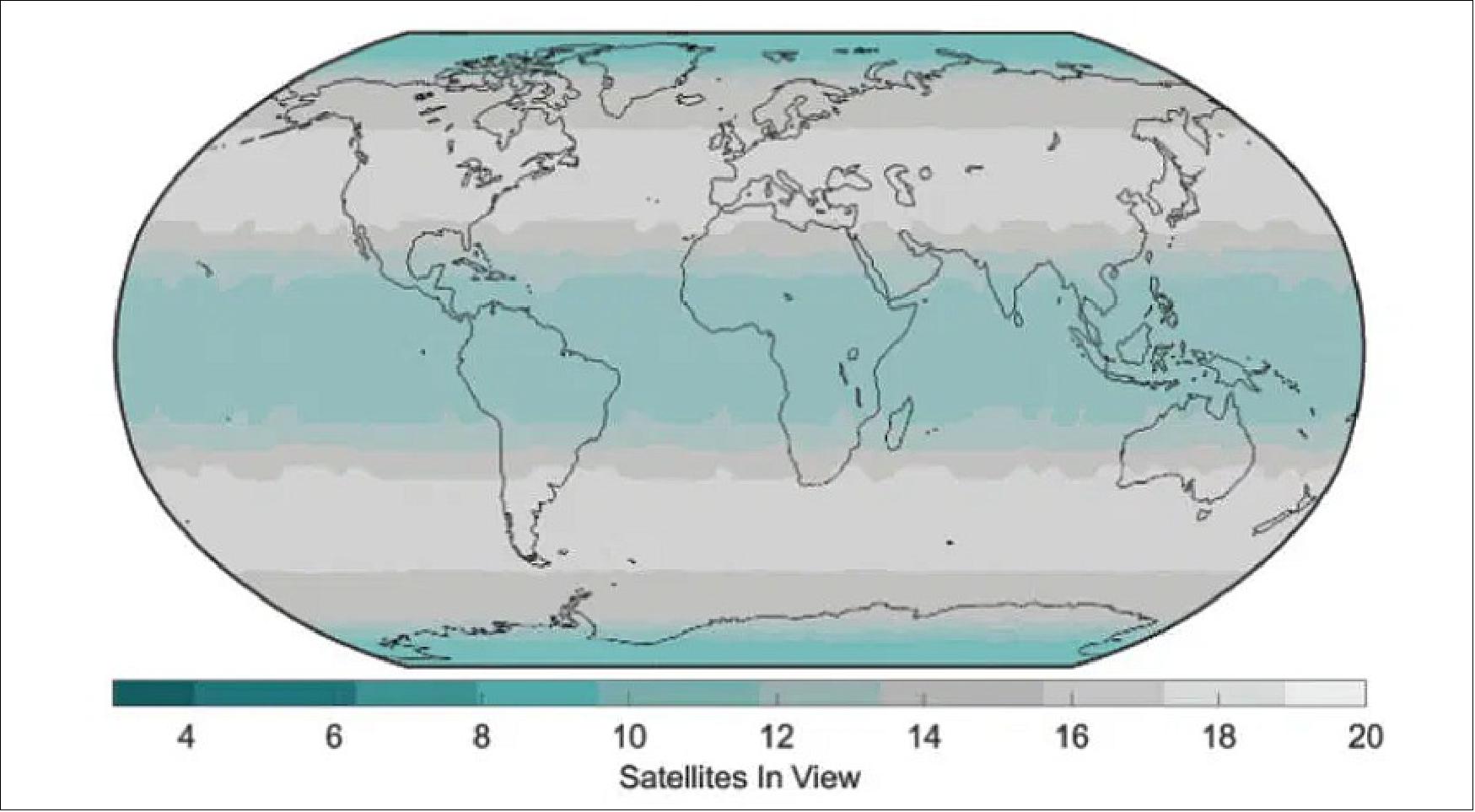
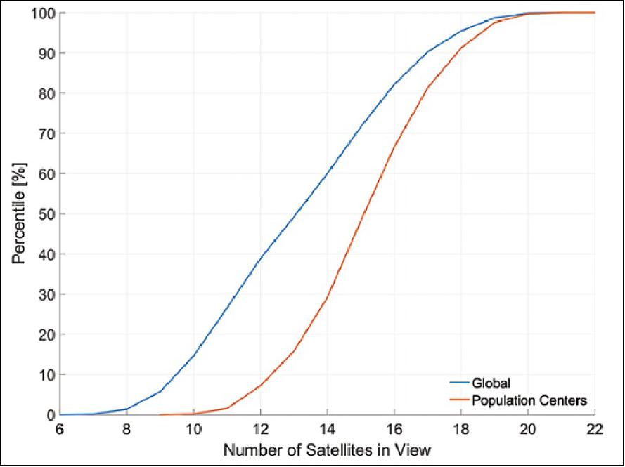
Figures 4 and 5 show the cumulative distribution of satellite visibility and dilution of precision, respectively. This yields a median number of satellites in view of around 15 with a VDOP (Vertical Dilution of Position) of 1.2 in population centers. It shows the Xona Pulsar constellation as designed can offer GPS-level performance in visibility and geometry, supporting users at all latitudes.
The concept represents a new space approach to commercial satellite navigation, one architected to meet the PNT needs of demanding critical applications, including autonomous vehicles. It leverages the ecosystem that has enabled the mega constellations including SpaceX, OneWeb, Telesat and Amazon.
These factors comprise orders of magnitude in cost reduction in access to space with reusable launch vehicles along with new techniques in high volume satellite production. The latter has led to the added benefit of a healthy supply chain of off-the-shelf space-capable components. The commercial constellation is designed for LEO to use mega-constellation satellite buses, components and launch systems intended for that regime and to provide higher performance to the end user.
Satellites are designed for flexibility and with a 5-year lifetime, allowing for faster refresh cycles to keep pace with ever increasing commercial PNT demands. To achieve the required performance and reliability, Xona introduces a distributed architecture that leverages an interconnected lightweight space segment along with enterprise ground station services to achieve GNSS independence. It combines familiar signals elements with novel ones for new capability and added resilience, including stronger, spectrally diverse signals with encryption and authentication for civil users.
Development Status
• May 10, 2022: Xona Space Systems, the aerospace startup developing a precision navigation and timing system in low Earth orbit, today announced that their first in-space demonstrator has been delivered to Spaceflight Inc. for final integration after successfully completing testing and is scheduled for launch on SpaceX’s Transporter-5 in May. Xona is building the first ever independent high-performance satellite navigation and timing system designed to meet the needs of intelligent systems. 4)
- Historically, satellite navigation systems such as GPS and Galileo have been exclusively in the domain of major governments with a price tag into the 10s of billions of dollars. The new space era has brought phenomenal new capabilities to market though at orders of magnitude lower cost which has led to a wave of new commercial capabilities sprouting in satellite communications and Earth observation. Xona is leveraging the new-space ecosystem to bring the benefits of the commercial space age to a different industry: satellite navigation and timing.
- Xona Space is launching Huginn, the first of two missions, demonstrating the capability of their Pulsar constellation. Pulsar’s revolutionary architecture uses small but powerful satellites in low Earth orbit, more than 20 x closer to Earth than GPS, to deliver high-performance navigation and timing services. Pulsar combines modern security and signal designs with Xona’s patent-pending distributed atomic clock architecture to enable robust precision navigation services to be provided from low-cost satellites.
- Huginn will transmit the first precision navigation signals from a LEO spacecraft, designed to test and validate the core software and hardware technology that Xona has developed for Pulsar. The mission will also demonstrate the functionality of the end user equipment on Earth and supporting ground systems. Huginn is now going through final integration with Spaceflight in preparation for launch on the scheduled Transporter 5 mission in May. This mission marks a huge step towards realizing a new generation of navigation systems.
- “We’re thrilled that Huginn has successfully completed its very rigorous test campaign in preparation for launch and are incredibly proud of the Xona team for achieving such a critical milestone,” said Brian Manning, CEO of Xona. “ Through this process we learned a massive amount and will be incorporating these lessons into our second demo mission as well as the production satellites.”
- Following the Launch of Huginn, the Xona team is shifting its focus to the second demonstration mission as well as the development of the Block I Pulsar system. The final Pulsar constellation will consist of several hundred satellites in low Earth orbit, delivering secure and robust precision PNT services designed to meet the needs of advanced applications such as self-driving cars, precision agriculture and construction, augmented reality, critical infrastructure, and many others.
- “It is inspiring to see what this team has been able to achieve going from a blank slate to orbit in less than a year from the time we completed our ground based prototype testing,” said Manning. “This is a huge step in the development and deployment of our Pulsar constellation, and we’re looking forward to a very exciting year here at Xona.”
• September 22, 2021: Californian startup Xona Space Systems has raised $8 million to fully fund an orbital demonstration next year of its navigation payload, which aims to provide an alternative to GPS and other global navigation satellite systems. 5)

- Early-stage investor MaC Venture Capital and Seraphim Space Investment Trust, a fund that was recently listed on the London Stock Exchange, led the funding round.
- Xona CEO Brian Manning said it brings the venture’s total funding to $10 million, including $1 million from a pre-seed round and another $1 million secured in grants.
- He declined to disclose who is building the test satellite, which he said will demonstrate hardware capabilities in addition to “software and test performance in various user applications.”
- The spacecraft has lined up a SpaceX Falcon 9 rideshare mission in mid-2022, brokered by Spaceflight, for what Xona says will be the first-ever launch of a dedicated, commercial positioning, navigation and timing (PNT) satellite.
- The demo satellite is part of a planned constellation of 300 CubeSats that Manning said Xona expects to start deploying in 2023.
- By operating in a much lower orbit than GPS and similar satellite navigation systems, Xona’s PNT services promise 10 times better accuracy than standard GNSS, delivered through encrypted signals.
- Xona also says its satellites will be unaffected by poor weather that can disrupt ground-based light detection and ranging (LIDAR) solutions for PNT.
- That is particularly important for the emerging autonomous vehicle industry, according to Xona, as U.S. Department of Transportation research shows more than 70% of roads in the United States and nearly 70% of its population live in snowy regions.
- “The world is massively dependent and reliant on GPS — much more so than it knows,” Manning said.
- He said the venture is still in the process of establishing manufacturing and launch agreements for the rest of its constellation, and is “actively coordinating” with regulators for the licenses it needs to operate the network in its projected time frame.
- According to Xona’s Sept. 22 funding announcement, it successfully tested its navigation system earlier this year in a ground-based demonstration.
- Toyota Ventures, the car manufacturer’s stand-alone venture capital firm, participated in Xona’s latest funding round, along with Daniel Ammann, who co-founded Swiss chipmaker u-blox, and Ryan Johnson, a former CEO Earth observation operator BlackBridge.
- Early-stage investors 1517 Fund and Stellar Solutions also supported the fundraising.
Improving GNSS
- A plethora of alternative PNT technologies has emerged in recent years to fortify and in some cases replace existing GNSS solutions.
- Washington-based Satelles has been providing assured PNT services to back up GNSS since 2016 over Iridium’s satellites in LEO.
- Using satellites that are about 25 times closer to Earth than GPS spacecraft in medium Earth orbit, Satelles says the signals its technology receives on the ground offer more accurate, secure and precise PNT services.
- Its Satellite Time and Location (STL) solutions have already been implemented in commercial applications that include protecting trading on the New York Stock Exchange.
- The company raised $26 million in its latest funding round in 2019, which Iridium participated in, to expand marketing efforts and accelerate product development.
- One of the most compelling emerging applications for alternative PNT is cybersecurity, Iridium CEO Matt Desch said, where backup GNSS solutions can help prove a device being communicated with is where it says it is.
- GPS signals that are available to civilians are not encrypted, leaving them susceptible to spoofing or other forms of disruption.
Pushing Alternatives
- In December, a coalition of PNT companies came together to support and accelerate efforts to back up GNSS capabilities for critical infrastructure.
- Satelles is administrator and facilitator for the Open PNT Industry Alliance lobby group, which has 18 members including Xona.
- The group champions a multi-technology approach, and is calling for a government funding framework to develop and adopt a system of systems approach to alternative PNT.
- Last year, the National Defense Authorization Act specifically called out for better PNT capabilities for the government and military, Xona’s Manning noted, while also underlining how this needs to be made available for civilians.
- Other countries apart from the U.S. have also been looking to fortify PNT services.
- Europe’s GNSS Galileo went live in 2016 to give member nations an alternative to GPS.
- Following Brexit, the British government has been looking for more sovereign PNT capabilities so the U.K. doesn’t rely solely on GPS or Galileo, including potentially using LEO broadband operator OneWeb’s constellation.
- Manning also pointed to China’s comprehensive multi-orbit plan for its GNSS BeiDou, which aims to operate from MEO, LEO as well as geostationary orbit (GEO) for stronger resiliency.
New Capabilities
- Historically, solutions to improve GNSS have largely focused on the ground at the receiver end.
- However, rapidly falling small satellite costs and the increasing accessibility of rocket launches are encouraging Xona and other startups to propose new space-based solutions.
- Manning believes the PNT industry is at a commercial inflection point where it makes more sense to improve GNSS services with CubeSats, which can broadcast stronger signals closer to Earth, rather than focusing on patching the service on the ground or improving accuracy with terrestrial solutions.
- He highlighted three problem areas for systems that solely rely on GPS: accuracy, security and resilience.
- While the couple meters of accuracy that current and planned upgrades to GPS offer civilians works for most human-operated devices, he believes this will not be precise enough for machines that are set to replace them for increasingly intricate tasks.
- Improved PNT precision is seen as a key enabler for autonomous cars, drones, ships and other emerging industries.
- On security, Manning said “the only GPS signal available to civilians has no authentication, security or encryption — that’s why you can send out fake signals because there is really no authentication or anything on it.”
- And because GPS architecture transmits at 27 watts per channel from 12,500 miles (20,120 km) away, the signal is weak enough to be vulnerable to malicious attackers, as well as unintentional interference from other radio sources or natural phenomena.
- “It’s kind of like listening to someone on a baby monitor from 1,000 miles away,” Manning said.
- “It’s incredible that your phone can pick it up or devices can get the signals at all, given that the signals are so incredibly weak, but that just makes them very vulnerable to disruption.”
• May 27, 2021: Xona Space Systems, a San Mateo-based startup creating the first ever secure and precise commercial Position, Navigation, and Timing (PNT) satellite service, today announced the formation of its strategic committee of trusted advisors. This Advisory Board includes distinguished government and public sector industry leaders whose focus will be to shape and guide the strategy and technological priorities of Xona Space Systems, working closely with the leadership team. 6)
- “We are thrilled to have the support of such an experienced and respected group of individuals guiding us on our path to developing a system that ushers in a new era of ubiquitous and reliable precision.” said Brian Manning, Co-Founder and CEO of Xona. “Satellite navigation and timing impacts nearly every aspect of our lives, and as we enter the age of autonomy, the dependency and performance demands are only increasing. The track record of the team we have assembled speaks for itself in their ability to build successful enterprises in supporting everything from consumer to critical government industries.”
- Introducing Xona's Advisory Board Members (in alphabetical order):
a) Daniel Ammann - Daniel Ammann has been working in the PNT industry since 1997 when he co-founded u-blox. He was in charge of all u-blox GNSS receiver products until 2019. Through his consulting company dammven GmbH, he continues to contribute to Satellite navigation businesses around the globe. He is also an active Business Angel and supports the startup scene in Zürich, Switzerland. His main interests are in bringing together the business and engineering worlds, in creating, nurturing and growing new businesses, and in future technology trends. Daniel is of Swiss nationality and lives in Zürich, Switzerland.
b) Rafferty Jackson - From the Beats by Dre sale to Apple for $3B, to The North Face and Vans reaching over $1B in the Americas, to taking Ubiquity Software public on AIM on the London Stock Exchange and selling it to Avaya, Rafferty has taken market defining companies through hyper-growth, investments, global expansion, acquisitions and IPO. Now at Jack Industries, she focuses on purpose and storytelling and invests in women-led companies through Astia Angels. She is a New Space and Autonomy advocate, mentoring at the Seraphim Space Camp and advising the New Vista Acquisition Corp. in addition to Xona Space Systems.
c) David Klinger, PhD - Dave Klinger is an Aerospace Consultant with broad experience as a design and systems engineer, program manager and executive on defense and commercial space programs. He led satellite development programs that included communications, PNT, imaging and missile warning systems. Following retirement as Executive Vice President of Lockheed Martin Missiles and Space, he was engaged by The Aerospace Corporation and Lockheed Martin performing risk assessments and readiness reviews of national space programs. He also served as a consulting professor at Stanford University helping students design CubeSats. He received a Ph.D. degrees in Aeronautics and Astronautics from Stanford University. His dissertation involved dynamics and control studies of the Stanford Gravity Probe B (Relativity Experiment) satellite.
d) Keith Masback – Keith Masback is internationally recognized authority on geospatial intelligence with over 30 years of experience. Today, he provides strategic advice and counsel to a diverse portfolio of leading-edge startups, focused on product-market fit, go-to-market planning and execution, mentoring, and executive coaching. He was recently appointed to the Mapping Sciences Committee of The National Academies of Sciences, Engineering, and Medicine. Previously, he served as an Army officer, a government senior executive, a member of the Intelligence Task Force of the Defense Science Board, a member of the Advisory Committee on Commercial Remote Sensing, and as the Chairman of the National Geospatial Advisory Committee.
e) Natalia Saidoglu, PhD - Natalia Saidoglu serves as Senior Space Systems Architect at Stellar Solutions. She began her space career as an RF antenna engineer at JPL, where she supported several Mars and Deep Space Missions. Post JPL, Natalia held various payload system development roles at Space Systems Group of Northrop Grumman Innovation Systems (previously Orbital) and MAXAR Technologies (previously SSL); and was a director of Payload Engineering at ABS Global. Natalia has PhD in Computational Electromagnetics from the National Academy of Sciences of Ukraine and has more than 30 publications. She is a recipient of MTT-S Graduate Student Microwave Fellowship Award and URSI Young Scientist Award.
f) Todd Walter, PhD -Todd Walter is a Research Professor in the Department of Aeronautics and Astronautics at Stanford University. He is also a member of the National Space-Based Positioning, Navigation, and Timing (PNT) Advisory Board. His research focuses on implementing satellite navigation systems for safety-of-life applications. He has received the Institute of Navigation (ION) Thurlow and Kepler awards. He is also a fellow of the ION and has served as its president.
• December 21, 2020: Xona Space Systems has been awarded a National Science Foundation (NSF) Small Business Innovation Research (SBIR) Phase I contract to conduct research and development (R&D) work on a space-based Atmospheric, Mapping and Satellite Integrity Monitoring (AMSIM) system to support high-integrity, precise positioning service from a Low Earth Orbiting (LEO) satellite navigation constellation. 7)
- This project requires monitoring satellites for faults and mapping ionospheric and tropospheric conditions, traditionally accomplished via a network of ground infrastructure, such as the Wide Area Augmentation System (WAAS). However, to achieve the precision needed for autonomous systems, ground monitoring stations must be spaced less than 100 km apart, limiting performance over oceans and other remote areas. This work proposes the investigation of a space-based monitoring approach for a ubiquitous service. It will leverage inter-satellite communication links for integrity monitoring, techniques in GNSS Radio Occultation (RO) for tropospheric monitoring, and tomography for ionospheric mapping. This Phase I project will use physical models, computer simulation, and available atmospheric data products derived from RO and ground-based monitoring approaches for validation.
- “NSF is proud to support the technology of the future by thinking beyond incremental developments and funding the most creative, impactful ideas across all markets and areas of science and engineering,” said Andrea Belz, Division Director of the Division of Industrial Innovation and Partnerships at NSF. “With the support of our research funds, any deep technology startup or small business can guide basic science into meaningful solutions that address tremendous needs.”
- “We are honored to have received our first NSF grant to support our development of the critical infrastructure needed to support the age of autonomy,” said Brian Manning, CEO of Xona. “As humans more routinely become passengers of modern technology rather than operators, the supporting infrastructure, including satellite navigation and timing services, must evolve to ensure these devices can operate safely at scale. We are thrilled to have this opportunity to drive the technology behind making this a reality.”
- Once a small business is awarded a Phase I SBIR/STTR grant (up to $256,000), it becomes eligible to apply for a Phase II grant (up to $1,000,000). Small businesses with Phase II grants are eligible to receive up to $500,000 in additional matching funds with qualifying third-party investment or sales.
- Startups or entrepreneurs who submit a three-page Project Pitch will know within three weeks if they meet the program’s objectives to support innovative technologies that show promise of commercial and/or societal impact and involve a level of technical risk. Small businesses with innovative science and technology solutions, and commercial potential are encouraged to apply. All proposals submitted to the NSF SBIR/STTR program, also known as America’s Seed Fund powered by NSF, undergo a rigorous merit-based review process.
• July 9, 2020: During the past two decades, satellite navigation became revolutionary — with more than 5 billion enabled devices, Global Navigation Satellite Systems (GNSS) find utility in nearly all facets of modern life, from the source of time for communications networks to the source of safety-critical positioning in civil aviation. 8)
- Now, another revolution has appeared on the horizon, one that promises disruption of transportation, mobility, and safety. Autonomous systems in the form of self-driving cars, aerial platforms and mobile robotics are on rise, targeting improved access to the mobility of people, goods, and services.
- This transformation is one whose complexity demands more than what today’s navigation systems can provide. Xona’s vision is one of a connected and autonomous future that leverages investment in new space infrastructure for navigation services that are robust, reliable, and secure.
- To understand where navigation is headed, we turn to the past to understand its evolution. One hundred years ago, the state-of-the-art was celestial navigation used by mariners at sea. The Second World War brought new needs with an emerging aviation market and spawned the advent of ground-based radio navigation aids. The Cold War brought satellites to navigation that eventually lead to the familiar GPS (Global Positioning System) that became operational in the mid 1990s.
- Looking at capability over time, this progress reveals a clear trend: within the last century, there has been an order of magnitude improvement in location accuracy every 30 years. Each step has required investment in new infrastructure to reach new capabilities. With meter-level positioning first widely available in the mid-1990s with GPS, this implies that the mid 2020s will demand decimeter, or better, performance.
- Autonomous systems are one of many coming applications that drive this need. Localization is a foundational element of autonomous driving. Knowledge of precise vehicle location, coupled with highly detailed maps, add the context needed to drive with confidence.
- Though some have shown progress in meeting these needs in certain circumstances or conditions, they all struggle to fully solve the problem to the level of reliability, safety, and security that will ultimately be needed. LiDAR and vision struggle in inclement weather due to absorption or scattering and is further hindered by occlusions. Radar, though more impervious to weather, is limited by sensor noise and resolution. LiDAR, vision, and radar approaches also require a data intensive localization map layer which must be maintained and updated frequently.
- GNSS technologies have also seen substantial investment in the Advanced Driver Assistance System (ADAS) and autonomous driving domains. There is now continent-scale deployment of GNSS monitoring stations in service, delivering correction services via cellular.
- The accuracy required for lane-determination to support future ADAS applications is nearing production where research systems are approaching that needed for full self-driving. Though GNSS accuracy is approaching the needs of autonomy, other risks remain with availability, interference, and cybersecurity.
- RF interference is a growing threat on the road. Often motivated by privacy concerns, low-cost GNSS jammers are a popular means of disrupting fleet tracking. Between 2016 and 2018, more than 50,000 such disruptions were recorded on European roads alone.
- The cybersecurity of GNSS is another emerging and perhaps even more menacing threat. Designed in the 1970s, civil GNSS signals are unencrypted and unauthenticated, leaving vulnerabilities that can be exploited with counterfeit (spoofed) signals.
- Less than ten years ago, GNSS spoofing required specialized expertise and equipment that cost upwards of $50,000. Now, with open source software and more accessible hardware, spoofing attacks can be accomplished for as little as $100.
- With increasing accessibility to spoofing technology has come a higher frequency of, and increased severity, of attacks. For example, at the 2019 Geneva Motor Show, several automotive manufactures including Audi, Peugeot, Renault, Rolls-Royce, Volkswagen, Daimler-Benz, and BMW reported their vehicles’ GNSS to be in Buckingham, England, in the year 2036, the result of a suspected widespread spoofing attack. Later in 2019, researchers at Regulus Cyber demonstrated this vulnerability in autonomy with a staged spoofing attack on a Tesla Model S and Model 3, creating unsafe behavior of the autopilot.
- The challenge to be faced is how to achieve localization requirements on accuracy, availability, integrity, continuity, scalability, and security while maintaining reasonable Cost, Size, Weight, and Power (CSWaP). Furthermore, autonomous systems will interoperate in our cities, necessitating a common standard.
- The safest maneuvers are informed with the most complete picture of the surroundings. This requires going beyond the line of sight of vehicle sensors and creating situational awareness at city levels. This demands an environment of collaborative data sharing through vehicle communication. Such a framework enables vehicles and infrastructure to act collectively, improving safety and reducing the risk of collision. Such data sharing is only effective if there is an agreed upon standard and datum with appropriate measures for data security.
- Investment in infrastructure for the establishment of such a standardized system offers the potential for the most economical and lightweight navigation solution for the end user. Satellite navigation offers a ubiquitous reach with established global datums and thus is considered the logical choice for such a universal standard.
- To meet these demands, Xona is building a navigation service to be delivered from Low Earth Orbiting (LEO) smallsats. Compared to GNSS in Medium Earth Orbit (MEO), such satellites will be located 20 to 40 times closer to Earth, having substantial implications for user performance and satellite payload cost. LEO satellites can provide robust position accuracy, in part through rapid estimation of carrier phase ambiguities via speedier motion across the sky. Proximity to Earth leads to stronger signals for the end user, giving better tracking performance and substantial resilience in the face of RF interference.
- Lastly, such a signal is not bound by legacy systems and can be designed with modern encryption and data authentication for resistance to spoofing attack. Traditionally the domain of government organizations, building a commercial satellite navigation service is unprecedented. However, there is also revolution underway in the space sector. The new space movement challenges the traditional approach and has resulted in a tenfold reduction in the cost per kilogram to orbit in recent years.
- Satellites and components have become commoditized and roll off assembly lines instead of being individually crafted for each mission. These ingredients create an ecosystem where Mega Constellations of thousands of satellites are being constructed by the likes of SpaceX, Telesat and Amazon to meet the global demand for broadband.
- The GNSS satellites of today host kilowatt navigation payloads, which use space-rated atomic clocks to drive a half dozen signals toward Earth. These live in MEO in the outer Van Allen radiation belt, the harshest environment that Earth satellites operate in today.
- Moving to LEO offers several opportunities. First, the tens of billions of dollars of GNSS infrastructure above in MEO can be leveraged. This gives access to a long-term frequency standard, where other clocks such as Oven Control Crystal Oscillators (OCXO) can be considered for the shorter term on satellites in LEO.
- A GNSS receiver onboard the satellite has further implications for orbit determination, where sub-decimeter GNSS-based orbit determination has already been demonstrated in real-time. Complexity is further reduced by virtue of the operating environment, where LEO radiation levels are more amenable to Commercial-Of-The-Self (COTS) components of automotive or industrial grade. The trade-off is in the numbers, where it takes around 300 LEO satellites to match the coverage of the 30 or so GPS satellites in MEO today. These elements combine to create the conditions for a streamlined navigation payload which can be supported by several commodity satellite buses.
Launch
The Xona Space Huginn passenger payload was launched on the Transporter-5 rideshare mission of SpaceX on 25 May 2022 at 2:35 p.m. EDT (18:35 GMT) from Cape Canaveral (SLC-40) aboard a SpaceX Falcon 9 rocket.
Orbit: Sun-synchronous orbit with an altitude of 525 km and an inclination of ~97º.
Mission Status
• June 7, 2022: Startup Xona Space Systems is preparing to demonstrate services from a test satellite to the first major customer for its planned navigation constellation. 10)
- Canadian GPS equipment and solutions provider NovAtel, which said May 31 it has signed up to be an early adopter of Xona’s proposed network of around 300 CubeSats, plans to use the in-orbit test bed to configure its technology.
- NovAtel is part of publicly listed technology provider Hexagon — which generated about $4.7 billion in net sales in 2021 — and is one of the largest makers of GPS signal receivers.
- The company has signed a memorandum of understanding to use Xona’s services while also helping to develop them.
- California-based Xona built the test satellite, called Huginn, in-house and it was one of several dozen payloads that SpaceX launched in a May 25 Falcon 9 rideshare mission.
- Huginn is still undergoing health checks that it needs to complete before starting demonstrations, Xona CEO and co-founder Brian Manning told SpaceNews June 7. The commissioning phase for a satellite can take several weeks from launch, and this can vary massively depending on the type of satellite and complexity of the mission.
- Once complete, Manning said Huginn aims to show the performance advantages its planned Pulsar constellation would have over GPS, and other global navigation satellite systems (GNSS).
- By operating in a much lower orbit, Xona says its positioning, navigation and timing (PNT) services would deliver 10 times better accuracy than standard GNSS.
- Pulsar satellites are also designed to operate in poor weather that can disrupt ground-based light detection and ranging (LIDAR) solutions for PNT.
- Manning said this means a customer would be able to know what lane they are driving in, even when lane lines are not visible, compared to existing GNSS systems that are only accurate enough to show which road their vehicle is on.
- The startup sees growing demand for its PNT capabilities in the emerging autonomous vehicle industry, which is one of the markets Hexagon serves.
- Manning said Xona has other “various commercial customers who are developing equipment to be compatible” with Pulsar satellites, which he expects to start deploying in low Earth orbit by early 2025.
Lengthy Tests Required
- He said a second prototype satellite Xona is building in-house called Muninn has secured a launch contract for deployment in early 2023.
- Huginn and Muninn are essentially twins, although “Muninn will have some internal upgrades based on what we learned from Huginn,” he said.
- “With Muninn we plan to expand the geographical regions that we are testing in, and also test more advanced user scenarios on the ground with multiple satellites in view instead of just one,” Manning said.
- Xona has raised about $10 million to date and seeks to secure more funds to support its proposed constellation.
- Manning declined to comment on whether Xona will seek to outsource production for Pulsar.
- For now, he said the startup is focusing on using Huginn and Muninn to ensure its technology can operate safely in any environment.
- “One of the biggest keys to operating a successful satellite navigation system is reliability, especially when you are building a system to support safety critical applications such as autonomous driving,” he said.
- “This can be designed in as best as possible, but at the end of the day just requires a lot of test cycles to make sure that when we launch the system can be trusted in applications where failure could have fatal consequences.”
- He said Xona’s ground operations systems, satellite systems and end user equipment are all “brand new designs, so each will be tested individually as well.”
References
1) ”Xona passes critical testing milestone as private GNSS readies for launch,” PR Newswire, 10 May 2022, URL: https://www.prnewswire.com/news-releases/xona-passes-critical-testing-milestone-as-private-gnss-readies-for-launch-301542835.html
2) Tyler Reid, ”Launching Xona’s Ravens: Commercial Satnav from LEO,” Inside GNSS, 18 May 2022, URL: https://insidegnss.com/launching-xonas-ravens-commercial-satnav-from-leo/
3) T. G. R. Reid, A. M. Neish, T. Walter, and P. K. Enge, “Leveraging Commercial Broadband LEO Constellations for Navigation,” Proceedings of the 29th International Technical Meeting of The Satellite Division of the Institute of Navigation (ION GNSS+ 2016), 2016, pp. 2300–2314, https://www.gps.gov/technical/icwg/IS-GPS-200M.pdf
4) ”Xona passes critical testing milestone as private GNSS readies for launch,” Xona Press Release, 10 May 2022, URL: https://www.xonaspace.com/xonapassescriticaltestingmilestone
5) Jason Rainbow, ”Xona Space Systems fully funds GPS-alternative demo mission,” SpaceNews, 22 September 2021, URL: https://spacenews.com/xona-space-systems-fully-funds-gps-alternative-demo-mission/
6) ”Xona Space Systems Announces Formation of Advisory Board,” XONA Press Release, 27 May 2021, URL: https://www.xonaspace.com/pr20210527
7) ”Xona Space Systems Awarded Competitive Grant from the National Science Foundation,” Xona Space Systems, 21 December 2020, URL: https://www.xonaspace.com/amsim
8) Tyler Reid, ”The Road To Robust Navigation,” SatMagazine, July 2020 Edition, URL: http://www.satmagazine.com/story.php?number=458493854
9) Tyler G. R. Reid, Sarah E. Houts, Robert Cammarata, Graham Mills, Siddharth Agarwal, Ankit Vora, Gaurav Pandey, ”Localization Requirements for Autonomous Vehicles,” SAE Int. J. Connect. Autom. Veh., vol. 2, no. 3, pp. 12-02-03–0012, Sep. 2019, doi: 10.4271/12-02-03-0012, URL: https://arxiv.org/pdf/1906.01061.pdf
10) Jason Rainbow, ”Xona to test GPS-alternative demo satellite with customer,” SpaceNews, 7 June 2022, URL: https://spacenews.com/xona-to-test-gps-alternative-demo-satellite-with-customer/
The information compiled and edited in this article was provided by Herbert J. Kramer from his documentation of: ”Observation of the Earth and Its Environment: Survey of Missions and Sensors” (Springer Verlag) as well as many other sources after the publication of the 4th edition in 2002. - Comments and corrections to this article are always welcome for further updates (eoportal@symbios.space).
Development Status References Back to top