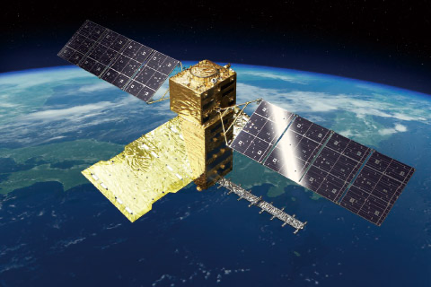
ALOS-4 (Advanced Land Observing Satellite-4 )
EO
JAXA
Atmosphere
Ocean
The Advanced Land Observing Satellite-4 (ALOS-4) is a Japanese Aerospace Exploration Agency (JAXA) mission aimed at observing and monitoring disaster-hit areas, forests, sea-ice, and monitoring infrastructure displacement. ALOS-4 was launched in July 2024 and replaces the ALOS-2 mission, with an improved sensor.
Quick facts
Overview
| Mission type | EO |
| Agency | JAXA |
| Mission status | Commissioning |
| Launch date | 1 July 2024 |
| Measurement domain | Atmosphere, Ocean, Land, Gravity and Magnetic Fields, Snow & Ice |
| Measurement category | Multi-purpose imagery (ocean), Multi-purpose imagery (land), Vegetation, Albedo and reflectance, Gravity, Magnetic and Geodynamic measurements, Landscape topography, Sea ice cover, edge and thickness, Soil moisture, Snow cover, edge and depth, Ocean surface winds, Atmospheric Winds, Ice sheet topography |
| Measurement detailed | Ocean imagery and water leaving spectral radiance, Land surface imagery, Vegetation type, Fire fractional cover, Earth surface albedo, Land surface topography, Wind vector over sea surface (horizontal), Sea-ice cover, Snow cover, Soil moisture at the surface, Iceberg fractional cover, Sea-ice type, Glacier motion, Sea-ice sheet topography, Oil spill cover, Crustal Motion, Above Ground Biomass (AGB), Snow melting status (wet/dry) |
| Instruments | PALSAR-3, SPAISE3 (AIS) |
| Instrument type | Data collection, Imaging microwave radars |
| CEOS EO Handbook | See ALOS-4 (Advanced Land Observing Satellite-4 ) summary |
Summary
Mission Capabilities
ALOS-4 will carry the Phased Array type L-band Synthetic Aperture Radar-3 (PALSAR-3), an L-band Synthetic Aperture Radar (SAR), which will provide continuity with greater resolution in comparison to ALOS-2 for monitoring infrastructure development, forest management and land deformation and subsistence. ALOS-4 will also carry the SPace based AIS Experiment (SPAISE3), a high performance satellite Automatic Identification System (AIS), to monitor the oceans by receiving AIS signals from vessels.
Performance Specifications
PALSAR-3 will make microwave measurements at a frequency of 1270 Mhz in the L-band. It will be able to observe in three modes: Stripmap mode, ScanSAR mode and Spotlight mode. Stripmap mode will have a spatial resolution ranging from 3-10m and a swath width between 100-200 km while ScanSAR mode will have a spatial resolution of 25 m and a swath width of 700 km. Spotlight mode will have the greatest spatial resolution of 3m x 1m at a Swath width of 35 km.
ALOS-4 will fly in a Sun-synchronous orbit at an altitude of 628 km. It will have an orbital inclination of 97.9°, an orbital period of 97 minutes and a repeat cycle of 14 days.
Space and Hardware Components
ALOS-4 will have a mass of approximately 2990 kg and dimensions of 10 m x 20 m x 6.4 m. The prime contractor for the construction of ALOS-4 is the Mitsubishi Electric corporation. ALOS-4 will downlink data in the ka-band at a rate of 1.8 or 3.6 Gbps.
Overview
The Advanced Land Observing Satellite-4 (ALOS-4) is a Japanese Aerospace Exploration Agency (JAXA) mission, aimed at observing and monitoring disaster-hit areas, forests, sea-ice, and monitoring infrastructure displacement. The mission will also be able to monitor vessels in the oceans and heavy marine traffic areas. ALOS–4 will replace the current ALOS-2 mission and will have an improved sensor, the Phased Array type L-band Synthetic Aperture Radar-3 (PALSAR-3), which, when compared to its predecessor PALSAR-2 onboard ALOS-2, will achieve both higher resolution and a broader observation swath. The ALOS-4 will also be equipped with the SPace based AIS Experiment (SPAISE3), a high performance satellite Automatic Identification System (AIS) to detect signals from ocean vessels.

Monitoring Land Deformation and Subsidence
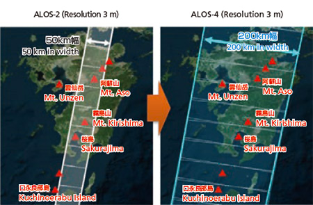
Radar satellites can measure diastrophism or ground transformation caused by volcanic activity of an earthquake up to a few centimetres by comparing acquired data in the same area at different times. The location of a magma reservoir and its movement from surface displacement can be estimated by continuously monitoring volcanoes, and such an estimation can contribute to understanding volcanic activities which is vital in Japan with high volcanic activity. ALOS-4 will increase the observation frequency to once every two weeks, when compared to ALOS-2 which flies in the same orbit and can observe one volcano just four times a year, so that disaster prevention agencies can find abnormal changes such as volcanic activity, land subsidence, or landslides, and provide early warning for the public. In addition, the swath width will be drastically increased from 50 km to 200 km while keeping a high resolution, enabling observation of a broader area at the same time when a large-scale disaster that damages wide areas occurs.
Forest Management
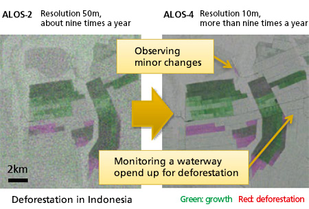
Forest covers 30% of all land area in the world, and deforestation is responsible for significant greenhouse gases net emissions. Therefore, forest conservation and assessment are important. JAXA and the Japan International Cooperation Agency (JICA) are cooperatively developing the JICA-JAXA Forest Early Warning System in the Tropics (JJ-FAST). Using observation data from ALOS-2, the JJ-FAST can detect areas of deforestation in the order of a few hectares, and is currently operational in 77 countries. However, there are many smaller deforestation areas, and ALOS-4 will conduct observations more frequently with five times more precision to detect smaller deforestation areas that cannot be monitored by ALOS-2.
Monitoring Infrastructure Development
JAXA carries out research to detect the annual displacement of structure due to the deterioration of dams, levees, port facilities and infrastructure by analysing time series of ALOS-2’s data. ALOS-4 will acquire data with more frequency, enabling the detection of annual displacement that grows slowly and gradually, such as structural distortion and subsidence, with precision of a few millimetres. Through such detailed observations, the satellite data is expected to be utilised for more efficient infrastructure maintenance.
Spacecraft
ALOS-4 will have a mass of approximately 2990 kg and dimensions of 10 m x 20 m x 6.4 m. It will be in a sun-synchronous orbit at an altitude of 628 km, an orbital inclination of 97.9 deg and have a 14 day revisit time. The prime contractor for the construction of ALOS-4 is the Mitsubishi Electric corporation. ALOS-4 will downlink data in the ka-band at a rate of 1.8 or 3.6 Gbps.
Launch
The Advanced Land Observing Satellite-4 (ALOS-4), also known as DAICHI-4, was launched on July 1, 2024 from the Tanegashima Space Center at 03:06 UTC.
Orbit: Sun-synchronous orbit, with an altitude of 640 km. 5)
Mission Status
July 1, 2024: The H3 rocket lifted off from the Tanegashima Space Center at 03:06 UTC, carrying the Advanced Land Observing Satellite-4 (ALOS-4), also known as DAICHI-4.
The two-stage launch vehicle flew as planned and ALOS-4 separated approximately 16 minutes and 34 seconds after liftoff, the JAXA announced.
ALOS-4’s solar arrays fully deployed, as confirmed by telemetry data received from the satellite at JAXA Mingenew Station in Australia. 7)
Figure 3: Liftoff of the third H3 rocket July 1 (UTC) carrying the ALOS-4 radar satellite. (Image credit: JAXA).
- April 26, 2024: JAXA announced a plan to launch a major upgrade to its satellite imaging system as H3, a new flagship rocket, is put to the test for a third time.
The H3 rocket will be launched from the Tanegashima Space Center.The 57-meter (187-foot) long H3 rocket is designed to carry larger payloads than the H-2A at about half its launch cost.
The launch will be the H3's third, coming after a failed debut in March 2023 and a successful launch on February 17, 2024. During H3 second test flight, it carried two commercially-developed observation microsatellites and an ALOS mockup.
JAXA and its main contractor Mitsubishi Heavy Industries (MHI) have been developing H3 as a successor to its current mainstay, H-2A, which is set to retire after two more flights. MHI will eventually take over H3 production and launches from JAXA and hopes to make it commercially viable. 6)
Sensor Complement
PALSAR-3
The Phased Array type L-band Synthetic Aperture Radar-3 (PALSAR-3) is a L-band Synthetic Aperture Radar (SAR). The L-band, which represents microwave measurements in the range 1-2 GHz, has continuously been developed in Japan. The instrument will measure at a frequency of 1270 MHz in the L-band. With the utilisation of digital beamforming techniques, the swath width of PALSAR-3 will improve while maintaining the ground resolution.
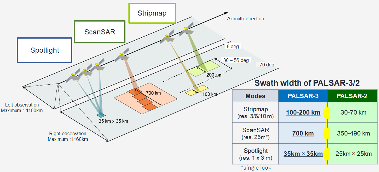
PALSAR-3 observes in three modes: Stripmap mode, ScanSAR mode and Spotlight mode. Regular stripmap mode observation is right-side, incidence angle of 30-44°. The other beams and left-side observation are used for quick disaster monitoring. The performance characteristics of the PALSAR instrument are presented in Table 1.
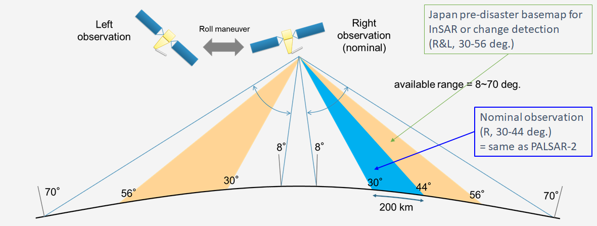
SAR mode | Spotlight | Stripmap | ScanSar | |||||
Centre Frequency (MHz) | 1257.5 | 1257.5 | 1236.5 or 1257.5 or 1278.5 | |||||
Bandwidth (MHz) | 84 | 84 | 42 | 28 | 28 | |||
Resolution (m) | 3x1 | 3 | 6 | 10 | 25(1look) | |||
Swath Width (Km) | 35 | 200 | 100 | 200 | 100 | 200 | 100 | 700(4scans) |
Available Incidence angle range (°) | 8-70 | 30-56 | 8-70 | 30-56 | 8-70 | 29-56 | 8-70 | 8-70 |
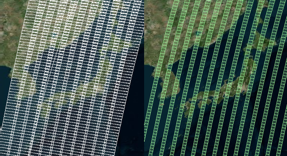
The images below show a comparison of the coverage of 1 repeat cycle (14 days) between PALSAR-3 and PALSAR-2.
SPAISE3
The SPace based AIS Experiment (SPAISE3) enables ALOS-4 to monitor the oceans by receiving AIS signals from vessels as well as by acquiring the PALSAR-3 images. SPAISE3 has eight antennas and adopts ground-based digital beam-forming (DBF) method as one of effective countermeasures against radio wave interference regions. Using this technology the detection success rate of ships in heavy marine traffic areas will be improved compared to SPAISE2. SPAISE3 development is JAXA’s ongoing project in cooperation with the Nippon Electric Corporation (NEC).
References
1) “JAXA | Advanced Land Observing Satellite-4 (ALOS-4).” Japan Aerospace Exploration Agency, https://global.jaxa.jp/projects/sat/alos4/.
2) “ALOS-4|ALOS@EORC.” ALOS-4|ALOS@EORC, https://www.eorc.jaxa.jp/ALOS/en/alos-4/a4_about_e.htm.
3) “ALOS-4|ALOS@EORC.” ALOS-4|ALOS@EORC, https://www.eorc.jaxa.jp/ALOS/en/alos-4/a4_sensor_e.htm.
4) “ALOS 4 - Gunter's Space Page.” Gunter's Space Page, 1 December 2021, https://space.skyrocket.de/doc_sdat/alos-4.htm
5) WMO OSCAR, “ALOS-4”, URL: https://space.oscar.wmo.int/satellites/view/alos_4
6) Yamaguchi, Mari, “Japan announces plans to launch upgraded observation satellites”, ABC News, April 26, 2024, URL: [web source no longer available]
7) SpaceNews, “H3 launches ALOS-4 advanced Earth observation satellite”, July 1, 2024, URL: https://spacenews.com/h3-launches-alos-4-advanced-earth-observation-satellite/