CRISTAL (Copernicus Polar Ice and Snow Topography Altimeter)
EO
ESA
Atmosphere
Ocean
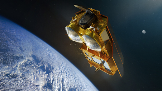
The Copernicus Polar Ice and Snow Topography Altimeter (CRISTAL) mission, is being developed by the European Space Agency (ESA) with the objective to measure and monitor sea-ice thickness, overlying snow depth and ice-sheet elevations. Also referred to as Sentinel-9, CRISTAL is the successor to CryoSat-2 and will feature two identical altimetry satellites built by Airbus Defense and Space (Airbus DS).
Quick facts
Overview
| Mission type | EO |
| Agency | ESA, COM |
| Mission status | Approved |
| Measurement domain | Atmosphere, Ocean, Land, Snow & Ice |
| Measurement category | Multi-purpose imagery (land), Atmospheric Humidity Fields, Ocean topography/currents, Sea ice cover, edge and thickness, Ocean surface winds, Ocean wave height and spectrum, Ice sheet topography |
| Measurement detailed | Atmospheric specific humidity (column/profile), Sea-ice cover, Wind speed over sea surface (horizontal), Sea-ice thickness, Significant wave height, Sea level, Ocean dynamic topography, Sea-ice sheet topography, Glacier topography, Ice sheet topography |
| Instruments | IRIS, AMR-C |
| Instrument type | Imaging multi-spectral radiometers (passive microwave), Radar altimeters |
| CEOS EO Handbook | See CRISTAL (Copernicus Polar Ice and Snow Topography Altimeter) summary |
Summary
Mission Capabilities
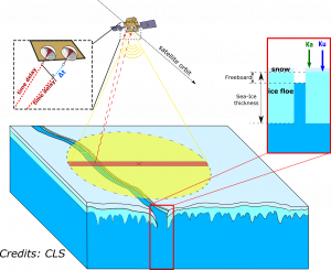
CRISTAL will feature a payload that comprises an Interferometric Radar altimeter for Ice and Snow (IRIS) and a Microwave Radiometer (MWR). IRIS will be used to measure the thickness of sea ice and the snow that covers it, as well as the height of the world’s ice sheets and glaciers. The dual-frequency operation will enable more accurate measurements than earlier ice-monitoring altimeters. These datasets will support maritime operations in polar oceans and contribute to a better understanding of climate processes through monitoring the cryosphere to fully assess, predict and adapt to climate variability and change.
Performance Specifications
IRIS follows on from the CryoSat SIRAL instrument, with improved characteristics including a dual band frequency. The dual-frequency radar altimeter operates in the Ku-band at a frequency of approximately 13.5 GHz and Ka-band at approximately 35.75 GHz, each having a bandwidth of 500 MHz. It features a 10 km IFOV (instantaneous field of view). When used in SAR mode, the along-track resolution is 80 m.
It is set to undergo a drifting polar orbit with an altitude of approximately 699 km.
Space and Hardware Components
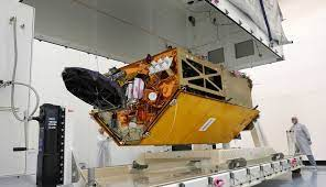
CRISTAL is being developed by Airbus DS with a mass of 1700 kg. The robust and proven satellite design builds upon the ocean topography mission, Sentinel-6, and the forerunning operational mission CryoSat-2. It includes six fixed and two deployable solar arrays spanning a total of 18.6 m2 and onboard storage for up to 4 TBits of data. It has a planned lifetime of 7.5 years.
Overview
The Copernicus Polar Ice and Snow Topography Altimeter, CRISTAL, mission will carry, for the first time, a dual-frequency radar altimeter, and microwave radiometer, that will measure and monitor sea-ice thickness, overlying snow depth and ice-sheet elevations.
These data will support maritime operations in the polar oceans and contribute to a better understanding of climate processes. CRISTAL will also support applications related to coastal and inland waters, as well as providing observations of ocean topography.
CRISTAL is part of the European Space Agency’s Copernicus Expansion program, in partnership with the European Commission. Copernicus is a European flagship program providing Earth observation and in situ data, along with a broad range of services for environmental monitoring and protection, climate monitoring and natural disaster assessment to improve the quality of life for all European citizens.
Spacecraft
The CRISTAL satellite has a mass of 1.7 tonnes. This includes six fixed and two deployable solar arrays spanning a total of 18.6 m2 and onboard storage for up to 4 TBits of data. It has a planned lifetime of 7.5 years. The robust and proven satellite design builds upon the ocean topography mission, Sentinel-6, and the forerunning operational mission CryoSat-2.
CRISTAL will also support applications related to coastal and inland waters and the observation of ocean topography. The mission will ensure the long-term continuation of radar altimetry ice elevation and topographic change records, following on from previous missions such as ESA’s Earth Explorer CryoSat, which was also developed by Airbus and has been working flawlessly for 12 years, well beyond its design lifetime of 7.5 years. Monitoring the cryosphere is essential to fully assess, predict and adapt to climate variability and change.
CRISTAL is set to undergo a drifting polar orbit with an altitude of approximately 699 km.
Mission Status
- July 2020: ESA signed a contract with Airbus Defence and Space as a prime contractor to build the satellite
- May 24 2022, Friedrichshafen: Following an intensive review process the European Space Agency ESA has confirmed that the preliminary design of CRISTAL meets all system requirements. The Preliminary Design Review (PDR) was organised using a new more collaborative format. As a first step an extensive review by over 60 ESA engineers of a comprehensive data package, established by more than 100 engineers led by Airbus took place over four weeks. In a second step the major findings were intensively discussed in an interactive way between senior level experts both on ESA and Industry side up to the successful completion of the review.
- The Airbus Defence and Space site in Friedrichshafen (Germany) is heading an industrial consortium involving companies from 19 countries to deliver the project, including Thales Alenia Space to provide the IRIS Interferometric Radar Altimeter. Following the successful PDR the CRISTAL project is now on track for the Critical Design Review (CDR) scheduled for May 2024. The satellite platform and instrument will then be integrated and tested in the new, highly digitalised integration centre at Airbus in Friedrichshafen.
- June 27, 2022, Toulouse: Thales Alenia Space signed an amendment to the CRISTAL contract with Airbus DS. The amendment provides for the development and qualification of IRIS to be carried on CRISTAL. Thales Alenia Space has completed the first phase in this contract (B2), awarded by Airbus in 2020, concerning the preliminary design of the altimeter, with the instrument passing its preliminary design review. It now enters the detailed design, qualification and final development phase (phase CD). The altimeter will be delivered to Airbus in 2025 for integration in the CRISTAL satellite.
Manufacturer contributions to CRISTAL
Thales Alenia Space in France is prime contractor for the IRIS altimeter, with Thales Alenia Space in Belgium providing the Ku and Ka-band solid state amplifier power supply, Thales Alenia Space in Italy the ultra-stable oscillator and Thales Alenia Space in Spain the S-band transponder (SBT).
"Thales Alenia Space is proud to contribute to the CRISTAL mission, which will play a critical role in understanding and monitoring climate change, as supplier of the IRIS altimeter, which draws on our long-standing expertise in space altimetry and proven flight heritage on SIRAL-2", said Hervé Derrey, President and CEO of Thales Alenia Space. “Polar regions have a real influence on global climate models, thermohaline circulation and the global energy balance. A long-term program to monitor Earth polar ice, ocean and snow topography, such as CRISTAL, is therefore extremely important.”
The development of the IRIS altimeter will call on the legacy of several advanced altimeters produced by Thales Alenia Space for major programs, including SIRAL-2, Poseidon 4 on Sentinel-6/Jason-CS, AltiKa on the CNES/ISRO SARAL satellite and KaRIn on the CNES/JPL SWOT satellite. Thales Alenia Space is also the first company to make an interferometric SAR altimeter (SIRAL) to be proven in orbit, confirming its unrivalled expertise in interferometric radar electronics and antennas.
Sensor Complement
The CRISTAL satellite will feature, for the first-time, a dual-frequency Ku/Ka-band radar altimeter to measure and monitor sea-ice thickness and overlying snow depth. Measurements of sea-ice thickness will support maritime operations and also help plan activities in the polar regions.
IRIS- Interferometric Radar altimeter for Ice and Snow
Thales Alenia Space is responsible for the development of two Interferometric Radar altimeter for Ice and Snow (IRIS) instruments for the mission. The instruments will be used to measure the thickness of sea ice and the snow that covers it, as well as the height of the world’s ice sheets and glaciers. The dual-frequency operation will enable more accurate measurements than earlier ice-monitoring altimeters. These datasets will support maritime operations in polar oceans and contribute to a better understanding of climate processes.
IRIS will also measure and monitor changes in the height of ice sheets and glaciers around the world, using its interferometric radar capabilities. IRIS will significantly improve the measurement accuracy of its predecessor, SIRAL-2 (a Ku-band only altimeter on ESA’s CryoSat-2 Earth Explorer mission), thanks to its dual frequency operation and the addition of sea surface height measurement capability. The CRISTAL mission operates on a global scope and is a key to better understanding and monitoring the Earth’s climate in a context of rapid climate change.
References
1) The Airbus Copernicus CRISTAL Mission Satellite Built For The ESA Successfully Passes The PDR – SatNews. (2022, May 24). SatNews. Retrieved November 20, 2022, from https://news.satnews.com/2022/05/24/the-airbus-copernicus-cristal-mission-satellite-built-for-the-esa-successfully-passes-the-pdr/
2) CRISTAL (Sentinel 9) - Gunter's Space Page. (2021, August 31). Gunter's Space Page. Retrieved November 20, 2022, from https://space.skyrocket.de/doc_sdat/cristal.htm
3) ESA - CRISTAL. (n.d.). European Space Agency. Retrieved November 20, 2022, from https://www.esa.int/ESA_Multimedia/Images/2020/09/CRISTAL
4) Kern, M. (2020, July 16). The Copernicus Polar Ice and Snow Topography Altimeter (CRISTAL) high-priority candidate mission. The Cryosphere. Retrieved November 20, 2022, from https://tc.copernicus.org/articles/14/2235/2020/
5) Norén, A. (n.d.). CRISTAL mission – The Polar Monitoring Project. The Polar Monitoring Project. Retrieved November 20, 2022, from https://www.polarmonitoringproject.org/the-cristal-mission/
6) Polar Ice and Snow monitoring mission CRISTAL on track. (2022, May 24). Airbus. Retrieved November 20, 2022, from https://www.airbus.com/en/newsroom/press-releases/2022-05-polar-ice-and-snow-monitoring-mission-cristal-on-track
7) Polar Monitoring WP2: Assessment and consolidation of mission requirements. (n.d.). The Polar Monitoring Project. Retrieved November 20, 2022, from https://www.polarmonitoringproject.org/wp-content/uploads/2020/07/PMM_Task2_report_TN2_v3.pdf
8) WMO OSCAR | Satellite: CRISTAL. (2022, August 30). WMO OSCAR. Retrieved November 20, 2022, from https://web.archive.org/web/20230628023452/https://space.oscar.wmo.int/satellites/view/cristal