DoT-1 (Demonstration of Technology-1)
EO
ESA
Ocean
Mission complete
Quick facts
Overview
| Mission type | EO |
| Agency | ESA, UKSA |
| Mission status | Mission complete |
| Launch date | 05 Jul 2019 |
| End of life date | 31 Jan 2025 |
| Measurement domain | Ocean, Land, Snow & Ice |
| Measurement category | Vegetation, Sea ice cover, edge and thickness, Soil moisture, Ocean surface winds, Ocean wave height and spectrum |
| Measurement detailed | Sea-ice cover, Soil moisture at the surface, Wind speed over sea surface (horizontal), Sea-ice thickness, Significant wave height, Above Ground Biomass (AGB), Sea-ice Concentration, Freeze/thaw, Surface inundation |
| Instruments | SGR-ReSI-CDHS |
| Instrument type | Other |
| CEOS EO Handbook | See DoT-1 (Demonstration of Technology-1) summary |
DoT-1 (Demonstration of Technology-1)
Launch Mission Status References
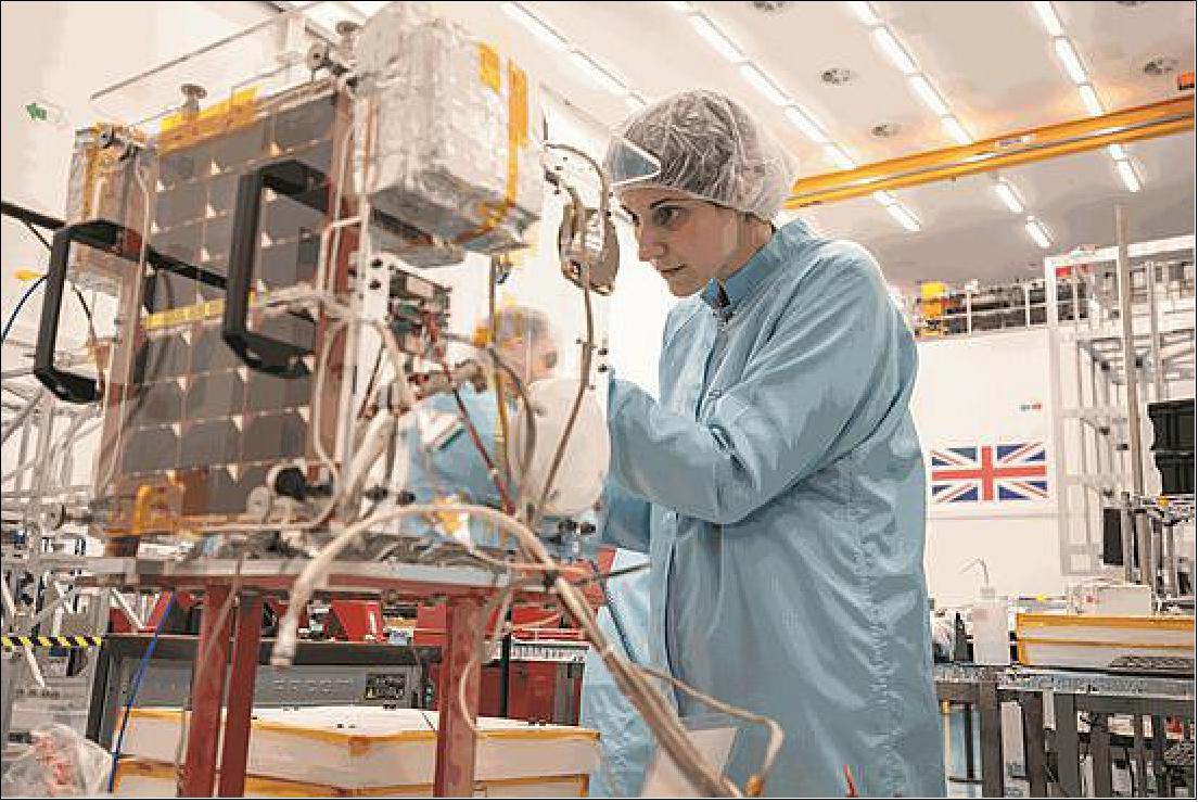
DoT-1 is a technology demonstration microsatellite mission (18 kg) with the objective trialling new generation avionics for SSTL (Surrey Satellite Technology Ltd) of Guildford, Surrey, UK. SSTL is part of Airbus. The self-funded DoT-1 satellite is to demonstrate SSTL’s new Core Data Handling System (Core-DHS). Accommodation was made available for some additional experimental payloads including the Raspberry Pi camera experiment which was designed and implemented in conjunction with the Surrey Space Centre (SSC).

Launch
The DoT-1 microsatellite was launched as a secondary payload on the Soyuz-2-1b Fregat-M rocket on 5 July 2019 (05:41 UTC) from the Vostochny Cosmodrome, Russia. The primary mission on this flight was the Meteor-M 2-2 satellite (2750 kg), a new generation meteorological mission of Russia, developed by VNIIEM and operated by Roskosmos. 1)
Orbit: Sun-synchronous orbit of the primary mission, altitude = 832 km, inclination = 98.6º.
Secondary Payloads (31 payloads, the rideshare mission was managed by Exolaunch)
• ICEYE-X4 and ICEYE-X4 SAR microsatellites of ICEYE Oy, Finland.
• Lemur-2 x 8 of Spire Global Inc., USA (8 3 U CubeSats)
• NSLSat-1, a 6U CubeSat of Clyde Space UK and NSLComm, Israel, Antenna deployment experiment, Ka-band communications experiment
• JAISAT-1, A Ham radio CubeSat, German Orbital Systems GmbH / Thai ham radio society
• EXOConnect, an experimental CubeSat of German Orbital Systems GmbH
• D-Star one, two experimental 3U CubeSats of German Orbital Systems GmbH
• Lucky-7, an experimental 1U CubeSat of SkyFox Labs, Czech Republic
• SEAM-2.0, a 3U CubeSat for Earth magnetic measurements of the Royal Technology Institute, Sweden
• MTCube (Robusta-1C), a 1U CubeSat for space radiation monitoring, Montpellier University, France
• SONATE, an experimental 3U CubeSat of the University of Würzburg, Germany
• BEESAT-9 to -13, five 1U CubeSats for orbital navigation and UHF intersatellite communications, Technical University of Berlin
• Move-2b, a 1U experimental CubeSat of the Technical University of Munich (TUM), Germany
• TTU-100, a 1U CubeSat for X-band and optical communications, Technical University of Tallinn, Estonia
• Ecuador -UTE, a 3U CubeSat for space weather and ionospheric research, Ecuador Technical University, Ecuador
• DoT-1, a (Demonstration of Technology) microsatellite (18 kg) of SSTL, UK
• MKA Sokrat, a CubeSat for space weather monitoring, Skobeltsin NIIYaF MGU, Russia
• VDNKhA-80, a CubeSat for space weather monitoring, Skobeltsin NIIYaF MGU, Russia
• AmurSat (AmGU-1), a CubeSat for space weather monitoring, Amur State University, AmGU, Russia.
• CarboNIX, Technology demonstration payload to test a new “shock-free” payload deployment mechanism, Exolaunch, Berlin
Orbits of the Secondary Payloads
After the successful release of its primary payload, the Fregat embarked on a complex pre-programmed sequence, including multiple firings of its main engine, to deliver its secondary payloads into two different orbits. The payloads in the microsatellite range were to be released at an altitude of 580 kilometers and inclination 97.7 degrees, while the nanosatellites (also known as CubeSats) were to be dropped at an altitude of around 530 kilometers and inclination 97.5 degrees. The latter group will include a cluster of eight Lemur satellites.
Mission Status
• September 10, 2020: Surrey Satellite Technology Ltd (SSTL) has successfully demonstrated GNSS-Reflectometry (GNSS-R) from its 18 kg DoT-1 satellite. SSTL has pioneered the new field of GNSS-R with successful payloads on board TechDemoSat-1 and the CYGNSS constellation, and is continuing to develop the technology and data analysis in pursuit of this new science. The latest GNSS-R payload on-board the DoT-1 satellite is incorporated within the new small form factor Core Avionics module integral to all SSTL’s future satellite platforms. This innovation paves the way for any SSTL satellite that can accommodate a nadir pointing antenna to become part of a GNSS-R small satellite constellation. 2)
- GNSS Reflectometry is an Earth observation technique that uses GNSS signals as L-band radar sources, allowing the satellite to take measurements of ocean wind speeds, polar ice and hydrological land parameters, at a higher spatial resolution and an order of magnitude lower cost than other methods.
- Phil Brownnett, Managing Director of SSTL, said “GNSS-R is a powerful new science that can contribute valuable data to help monitor changes in our global climate, and I am really pleased with the success of our DoT-1 demonstration. We now have an advanced instrument design and deep expertise in this new field and I am hopeful that SSTL’s HydroGNSS concept will progress to a full mission to support the global climate control challenge.”
- This GNSS-R technology demonstration from SSTL’s DoT-1 satellite is also an important stepping stone for a proposed ESA Scout Mission Concept called HydroGNSS which comprises two 40 kg satellites that collect data continually in near-polar orbits, taking hydrological measurements over the whole globe. The HydroGNSS mission concept makes advanced use of new GNSS Reflectometry techniques such as Galileo signals, dual polarization, and coherent signal acquisition to measure 4 Essential Climate Variables (ECVs) over land: Soil Moisture, inundation, permafrost freeze/thaw, and biomass. HydroGNSS has been down-selected by ESA for a concept study, and the finally selected Scout mission will commence in 2021.
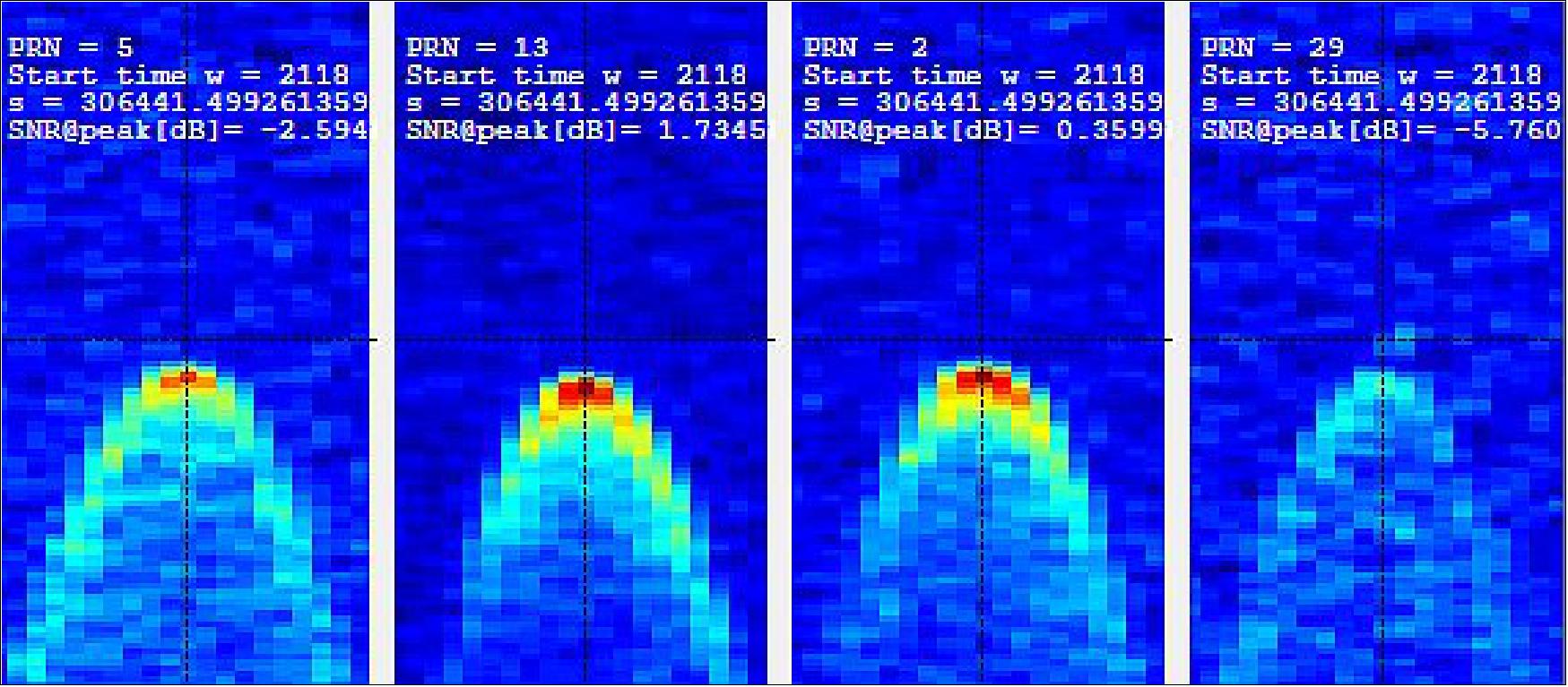
- SSTL’s GNSS-R instrument collects and processes measurements into a “Delay Doppler Map” (DDM) that can be corrected and inverted into Level 2 products such as ocean wind speed, as has already been successfully demonstrated by the SSTL GNSS-R instruments on-board the TechDemoSat-1 and CYGNSS missions. The plot below shows results from data gathered by the DoT-1 satellite on 12th August 2020 and shows simultaneous “Delay Doppler Maps” from four separate GPS satellites. As this is a forward scattering technique, the stronger signals with redder peaks indicate a calmer ocean with lower wind speeds. Approximately 40 minutes of data were collected from the Pacific to the Antarctic to the Southern Ocean.

- Data from the SSTL GNSS-R instruments on-board the CYGNSS mission have demonstrated the potential for soil moisture measurement by GNSS Reflectometry, and preliminary work shows that GNSS-R also has good sensitivity for Freeze-Thaw sensing in the active zone of permafrost. Unseasonal changes in the permafrost cycles could potentially release larger quantities of methane, which risks exacerbating global climate change. GNSS-R can also be used to assess biomass, a measure of forest density which acts as a vital sink for removing carbon dioxide from the atmosphere. In addition to longer term climate observations, soil moisture and inundation measurements from GNSS Reflectometry can provide important information for short term operational purposes, for example, towards Numerical Weather Prediction and flood warnings following rainfall events.

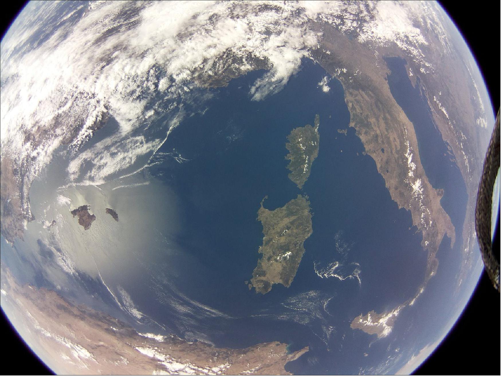
• September 5, 2019: SSTL has released an image (Figure 4) and video of the Earth captured from LEO by a commercial grade Raspberry Pi camera and computer on board a Demonstration of Technology satellite called DoT-1 that was launched to orbit via a Soyuz rocket in July of 2019. 3)
- The image is of the Mediterranean Sea, targeted over the islands of Corsica and Sardinia, and is believed to be the first acquired in LEO by a commercial, off-the-shelf, Raspberry Pi camera. Coincidentally, the image is remarkably similar in location to SSTL’s first image from space, acquired by the UoSAT-1 satellite in 1981.
- While the primary objective of the 17.5 kg DoT-1 satellite is to demonstrate SSTL’s new Core Data Handling System (Core-DHS) — accommodation was made available for some additional experimental payloads including the Raspberry Pi camera experiment, which was designed and implemented in conjunction with the Surrey Space Centre.
- After image capture using the camera, the data was stored on the Raspberry Pi computer and then downlinked to SSTL’s ground station in Guildford via the Core-DHS. The new Core-DHS is designed to provide the same level of functionality as SSTL’s heritage equivalent avionics stack, but with a significantly reduced mass and volume, and it consolidates the S-band Transmitter and Receiver, Global Positioning System, Attitude & Orbit Control System, Interface Module and Bridge and On Board Computer into one module.
- In designing the new Core-DHS, emphasis was placed on ensuring the module is fast to manufacture, test and integrate and, through the architecture and choice of devices, there is also a reduction in power consumption versus the individual equivalent units. The use of the Core-DHS throughout SSTL’s platform range will ensure continuity in software architecture and operations and it is intended that this key building block will be supporting missions beyond LEO orbit and into GEO and Lunar orbits.

- The DoT-1 satellite is an SSTL-Micro platform and is also flying further experimental payloads as part of SSTL’s ongoing R&D program. Further details of these experiments will be released in due course.
- Sarah Parker, Managing Director of SSTL said the company is delighted with the success of the new, Core-DHS-based avionics which will give the firm’s customers the benefits of SSTL’s heritage avionics stack, but in a lower form factor to deliver improved power consumption and lower launch costs. The success of the Raspberry Pi camera experiment is an added bonus that can now be evaluated for future missions where it could be used for spacecraft “selfies” to check the operation of key equipment as well as for outreach activities.
References
1) Anatoly Zak, ”Soyuz launches fresh Meteor weather watcher and 32 small satellites,” Russian Space Web, 5 July 2019, URL: http://www.russianspaceweb.com/meteor-m2-2.html
2) ”SSTL Demonstrates New GNSS-R Capabilities,” SSTL Press Release, 10 September 2020, URL: https://www.sstl.co.uk/media-hub/latest-news/2020/sstl-demonstrates-new-gnss-r-capabilities
3) ”Spectacular Image and Video Capture of Earth Managed by Raspberry PI Camera Aboard SSTL’s DoT-1 Satellite,” SSTL, 5 September 2019, URL: https://2019.smallsatshow.com/2019/09/05/
spectacular-image-and-video-capture-of-earth-managed-by-raspberry-pi-camera-aboard-sstls-dot-1-satellite/
4) ”DoT-1 Raspberry Pi image of Earth,” SSTL, URL: https://www.sstl.co.uk/media-hub/images/dot-1/dot-1-raspberry-pi-image-of-earth