DSCOVR (Deep Space Climate Observatory)
EO
Atmosphere
Cloud type, amount and cloud top temperature
Cloud particle properties and profile
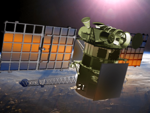
Launched in February 2015, DSCOVR (Deep Space Climate Observatory), is a deep space Earth observing satellite, owned and operated by NOAA (National Oceanic and Atmospheric Administration) with data processed by NASA (National Aeronautics and Space Administration). It aims to monitor space weather and climate, as well as provide deep space imagery of the Earth’s surface.
Quick facts
Overview
| Mission type | EO |
| Agency | NASA, NOAA, USAF |
| Mission status | Operational (extended) |
| Launch date | 11 Feb 2015 |
| Measurement domain | Atmosphere, Land, Gravity and Magnetic Fields |
| Measurement category | Cloud type, amount and cloud top temperature, Cloud particle properties and profile, Aerosols, Radiation budget, Vegetation, Albedo and reflectance, Gravity, Magnetic and Geodynamic measurements, Ozone, Trace gases (excluding ozone) |
| Measurement detailed | Cloud top height, Cloud cover, Cloud optical depth, Aerosol optical depth (column/profile), Magnetic field (vector), Leaf Area Index (LAI), O3 Mole Fraction, Photosynthetically Active Radiation (PAR), SO2 Mole Fraction, Upwelling (Outgoing) long-wave radiation at Earth surface, Vegetation Canopy (cover), Upwelling (Outgoing) Short-wave Radiation at the Earth Surface |
| Instruments | EPIC, NISTAR, PHA, FC, ES, PlasMag |
| Instrument type | Imaging multi-spectral radiometers (vis/IR), Earth radiation budget radiometers, Space environment |
| CEOS EO Handbook | See DSCOVR (Deep Space Climate Observatory) summary |
Summary
Mission Capabilities
DSCOVR carries four instruments, EPIC (Earth Polychromatic Imaging Camera), NISTAR (National Institute of Standards and Technology Advanced Radiometer), PHA (Pulse Height Analyser) and the PlasMag Instrument suite. EPIC is a ten channel UV/VIS/NIR (Ultraviolet/Visible/Near Infrared) radiometer with the objective of measuring ozone amounts, aerosol amounts, cloud height and phase, hotspot land properties, and UV radiation estimates. NISTAR is a three cavity radiometer, designed and developed by NIST (National Institute of Standards and Technology) with the objective of measuring the radiance output of the sunlit Earth. PHA is a HiLRS (High Linear Energy Transfer Radiation Spectrometer), that aims to monitor the effect of high energy particles on spacecraft electronics. The PlasMag Instrument suite consists of a Faraday cup, which aims to allow the investigation of solar wind waves and turbulence, and an electron spectrometer, which aims to provide full 3D distribution function observations of solar wind electrons.
Performance Specifications
EPIC has a maximum spatial resolution of 2.5 km, with a FOV (Field of View) of 0.61° and an angular sampling resolution of 1.07 arcseconds. Across its 10 channels, it has central wavelengths of 317 - 779 nm and bandwidths of 0.8 - 3.0 nm. NISTAR covers three spectral ranges, 0.2 - 100 µm for measurement of the total radiant power emerging from the Earth, 0.2 - 4.0 µm for measurement of the total reflected solar radiance and 0.7 - 4.0 µm for measurement of the fraction of solar radiance reflected in the NIR (Near Infrared), SWIR (Shortwave Infrared) and part of the MWIR (Medium Wave Infrared) bands. The instrument’s FOV is 1°, with pointing accuracy of 0.1%. The PlasMag Faraday cup has a temporal resolution of 0.5 seconds, and generates magnetic field data at a rate of 20 vectors/second, while the PlasMag electron spectrometer has an FOV of 4π steradians.
DSCOVR operates in a Lissajous orbit about L1 (Lagrangian Point 1) in the Earth-Sun system, allowing a unique view of both the Earth and the Sun, and is expected to leave service in 2026.
Space and Hardware Components
DSCOVR uses a SMEX-Lite (Small Explorer-Lite) bus that was manufactured by GSFC (Goddard Space Flight Centre). The bus has dimensions of 1.37 m x 1.87 m and a launch mass of 440 kg. The bus utilises a monopropellant blowdown propulsion system, consisting of one monopropellant tank, ten thrusters, one dual coil latching isolation valve and two pressure transducers. The propulsion system will be used for attitude control and minor adjustments for orbit maintenance.
DSCOVR (Deep Space Climate Observatory)
Spacecraft Launch Mission Status Sensor Complement Ground Segment References
DSCOVR is the former renamed NASA/NOAA mission Triana, proposed in 1998 by then Vice President Al Gore. The goal of Triana was to observe Earth as a planet (i.e. continuous full disk observation of the sunlit Earth) from L1, the first Lagrangian Point in the Earth-Sun system. The mission was named Triana after Rodrigo de Triana, the lookout, who spotted the New World on Christopher Columbus’s first expedition in 1492. 1)
Some background: The Triana mission development proceeded for 21 months, (a launch of the observatory was planned for early 2002), before it was de-manifested from the Space Shuttle in the spring of 2001 by the new Bush Administration in office. The official reasons stated were: “A constrained Shuttle flight rate of six per year, established in the 2001 NASA budget planning process, required that NASA give priority to the primary ISS (International Space Station) payloads, a Hubble Space Telescope (HST) reboost was needed, and microgravity experiments were planned to be launched.” Consequently, it was not possible to identify a definitive launch date for Triana. 2) 3) 4) 5) 6) 7) 8)
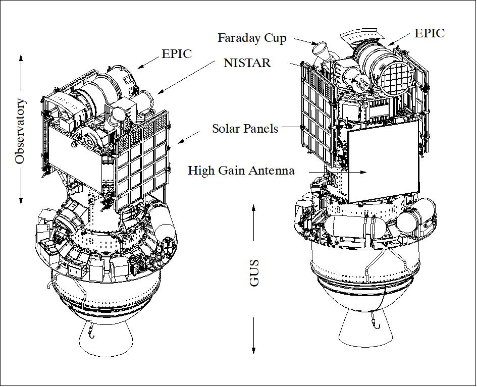
Legend to Figure 1: The Shuttle configuration contained also GUS (Gyroscopic Upper Stage) next to the Observatory. GUS was intended to boost the Observatory from LEO to the LOI (Lissajous Orbit Insertion) point.
The Triana observatory has been in a state of “Stable Suspension” since November 2001 (stored in a clean room at GSFC. After the mission was placed into suspension, it was renamed to DSCOVR (Deep Space Climate Observatory).
In 2008, the stored spacecraft was removed from storage. Power-on tests were performed to assess the current status of the observatory. This testing was successful, finding DSCOVR in nearly perfect condition after over 7 years of storage. In 2009, NASA provided funding to refurbish and recalibrate the two Earth science instruments, NISTAR and EPIC. In 2011, after a decade of stable suspension, NOAA, NASA, and the USAF are aligning again with plans to fully refurbish and launch DSCOVR possibly in 2014 (Ref. 1). Triana provided a solid foundation for DSCOVR, including advanced work on all observatory subsystems.
While maintaining its original instrument complement, DSCOVR will have a new primary function to monitor space weather. The satellite’s original purpose was to provide a near-continuous view of the entire Earth and make a live image available via the Internet.
The majority of the structure was intact, however the flight transponder, star tracker, IMU (gyros), and a reaction wheel had been deintegrated from the flight observatory and moved to multiple locations at GSFC. Some of the GSE (Ground Support Equipment) was impounded and some of the GSE had been reabsorbed into the GSFC infrastructure.
To distinguish this report from previous versions it was called “The Serotine Report.” Named after the serotinous or “late opening” pine cone which lies dormant for many years until activated by high heat: such as fire. The name of the report also has become attached to that team.
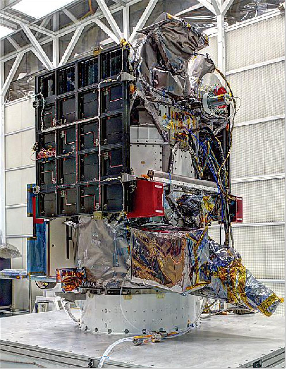
The DSCOVR mission, to be refurbished at NOAA expense and launched by the USAF, gives a unique opportunity to NASA to obtain unprecedented time resolution solar wind measurements for a minimal cost. The DSCOVR spacecraft is already built (Figure 2) and requires only an 18 month refurbishment to be ready for an operational space weather and scientific research mission. 9) 10)
The 1 AU, near-Earth solar wind has been observed by a number of NASA and international spacecraft over the past decades. However, particle instrumentation technology limitations did not allow the direct observation of the varying properties of the thermal solar wind particles in the kinetic regime, which requires measurements with better than 1 Hz cadence. Observations at this kinetic scale are essential to understand how the solar wind is continuously heated as it propagates away from the Sun, how small scale magnetic reconnection operates in the 1 AU solar wind, and how interplanetary shocks can accelerate particles to high energies.
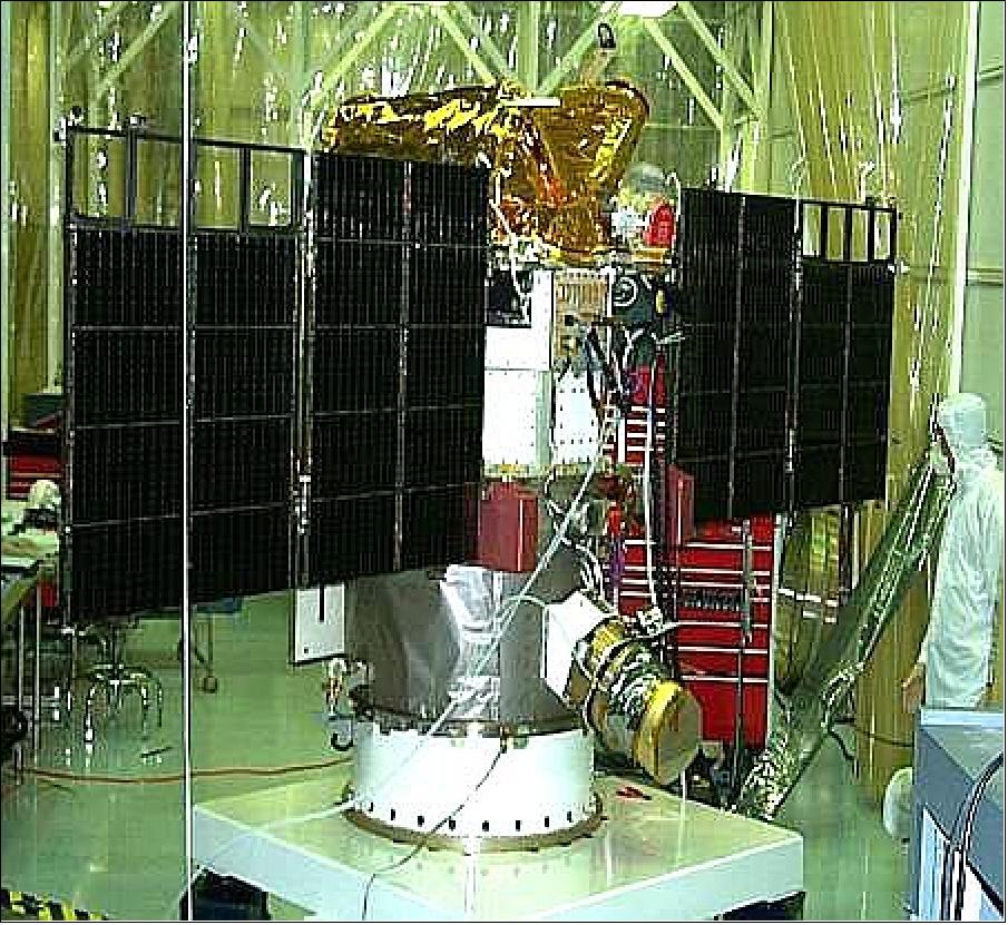
Figure 2: Photo of the DSCOVR spacecraft in the NASA/GSFC clean room (image credit: NASA, Ref. 9)
History and Current Status
• 1998: Triana mission initiated; involvement of Al Gore; launch planned for 2001
• 2001: Mission postponed (placed in “Stable Suspension” in November 2001)
• 2003: Mission, renamed to Deep Space Climate ObserVatoRy (DSCOVR); still one space weather system (PlasMag) and two Earth viewing instruments (NISTAR and EPIC)
• 2006: Mission terminated; satellite in storage
• 2009: Refurbishment of DSCOVR initiated; decision to change the filters in EPIC
• 2011: Finished refurbishment and laboratory calibration of EPIC; all instruments integrated on satellite; satellite electronics are being refurbished at GSFC
• 2012: DSCOVR mission is secured; possible launch 2014-2015
Spacecraft
DSCOVR is a multi-agency mission of NOAA, NASA and USAF (U.S. Air Force) with the primary mission goal of making unique space weather observations. The science objectives are: 12) 13) 14)
• Solar wind measurements at Earth-Sun Lagrange Point 1 (L1)
• Provision of 1-3 day early warnings of geomagnetic storm intensity. The consequences of solar storms are becoming more significant as society becomes increasingly dependent on technologies, from satellites to the electrical grid, that can be disrupted by a major storm. 15)
• DSCOVR will replace the NASA ACE (Advanced Composition Explorer) spacecraft in orbit since 1997
• Data downlink via the international RTSWnet (Real Time Solar Wind Network).
Mechanical structure: A full environmental test program, including vibration, strength, mass properties, acoustic, pyro shock, and alignment activities, is currently planned for DSCOVR. The Serotine team estimate includes funding to refurbish and/or rebuild portions of the mechanical GSE needed for this testing. During this study, the Serotine team rebuilt and certified the lifting GSE for the DSCOVR spacecraft and the EPIC instrument.
GN&C (Guidance Navigation and Control): The approach for DSCOVR includes using the original ACS dynamic simulator and not upgrading to a more costly advanced system, such as the one used for LRO (Lunar Reconnaissance Orbiter).
The DSCOVR star tracker was tested during this study using a star field simulator that attached to the tracker shade. While this is not a comprehensive performance test, the tracker did perform nominally. The current plan is to remove the star tracker and return it to Ball Aerospace for refurbishment. This will include some minor star tracker shade adjustments. Based on the testing performed by the Serotine team, no issues are expected during this refurbishment.
During the Serotine study, the DSCOVR reaction wheels were powered on and commanded to an assortment of speeds. All wheels performed nominally. The wheels were developed in-house at GSFC, and as part of DSCOVR’s refurbishment effort, will be removed from the spacecraft and sent to the development lab for comprehensive performance testing and evaluation. These wheels can not be disassembled due to their pressed on assembly techniques. However, stored samples of the original grease will be tested to verify the integrity of the wheels’ lubricant, which can not be directly sampled. This grease was also tested a few years ago and showed no degradation. The same grease was also used in an identical wheel that continues to perform flawlessly in its eighth year of powered life testing. Based on this and recent DSCOVR spacecraft testing, the Serotine team does not expect any issues with the DSCOVR wheels.
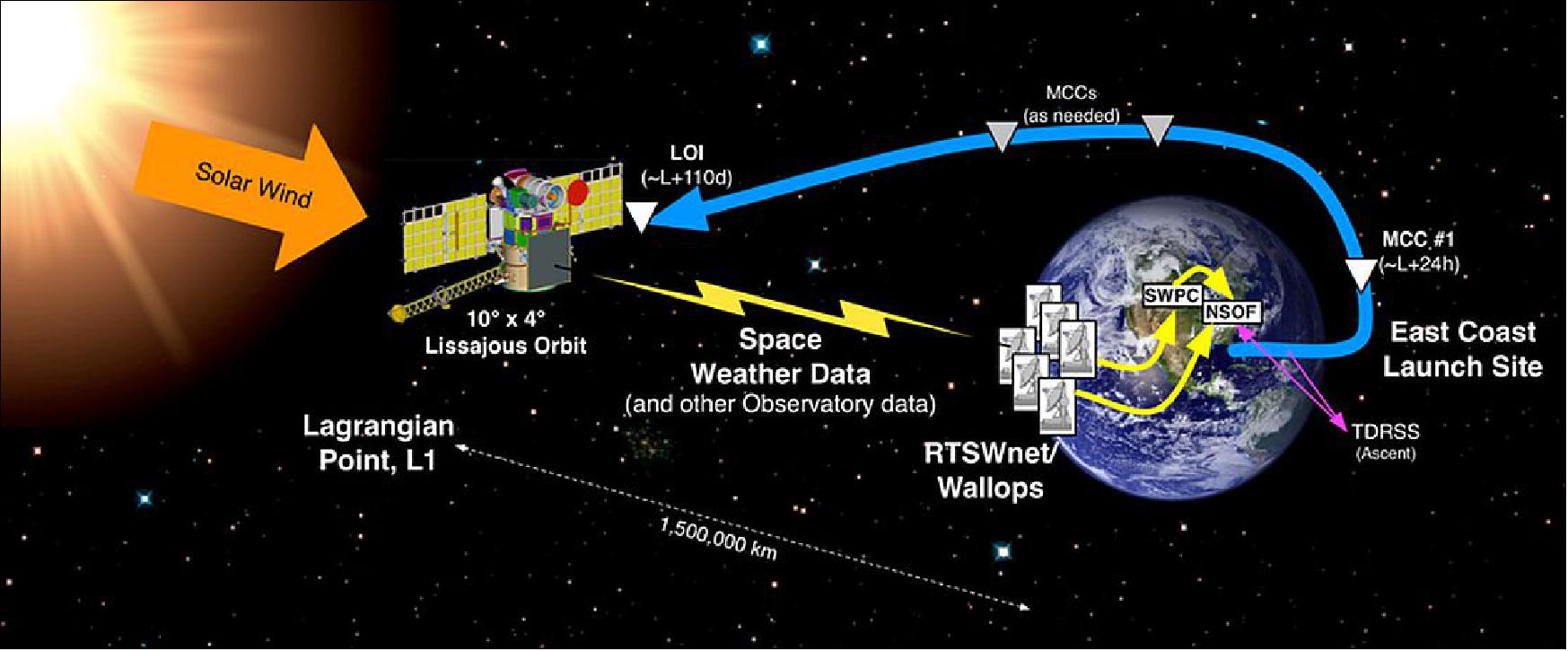
The DSCOVR propulsion subsystem is a monopropellant blowdown propulsion system. It consists of 1 monopropellant tank, 10 thrusters, 1 dual coil latching isolation valve, 2 pressure transducers. The DSCOVR propulsion control system is known as the EVD, part of the utility hub. Moog Inc. of Niagara Falls, N.Y. provided the MONARC-5 4.5 N monopropellant engines and thruster valves to NASA for the Triana mission in 1999. Moog provided critical technical support for recertification of the engines for the DSCOVR mission after more than 13 years in storage. The 5 N engines will be used for attitude control and minor adjustments to maintain the satellite’s orbit at L1. DSCOVR has two key burns: Mid-Course Correction (MCC) and Lissajous Orbit Insertion (LOI). The thrusters will be used to perform the MCC for 50 minutes and LOI for 5.3 hours. After reaching L1, DSCOVR will perform station-keeping and momentum unloading with the thrusters. 16)
The DSCOVR spacecraft has a launch mass of ~ 750 kg with a bus size of 137 cm x 187 cm. The nominal mission life is 5 years. 17) 18) 19) 20)
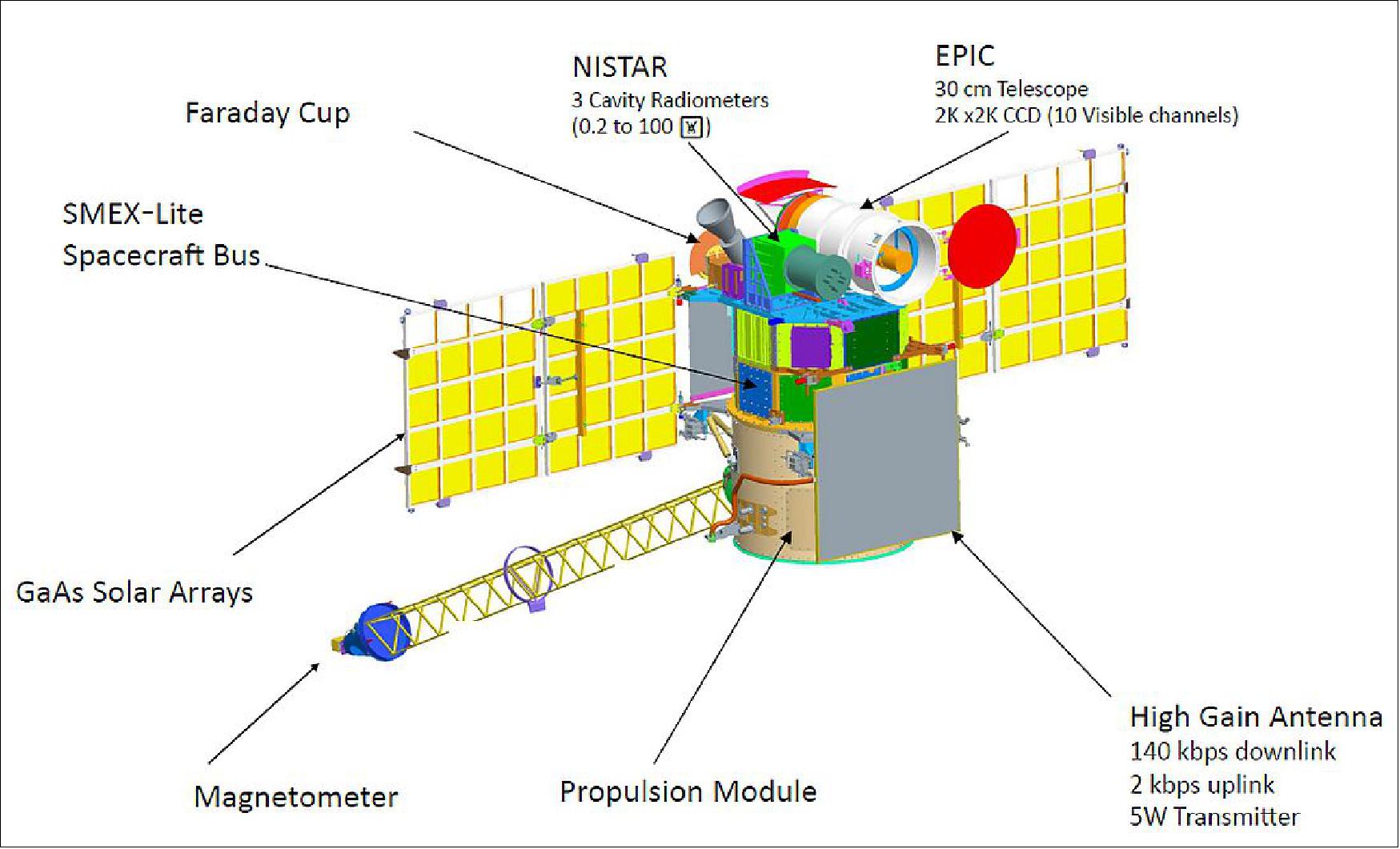
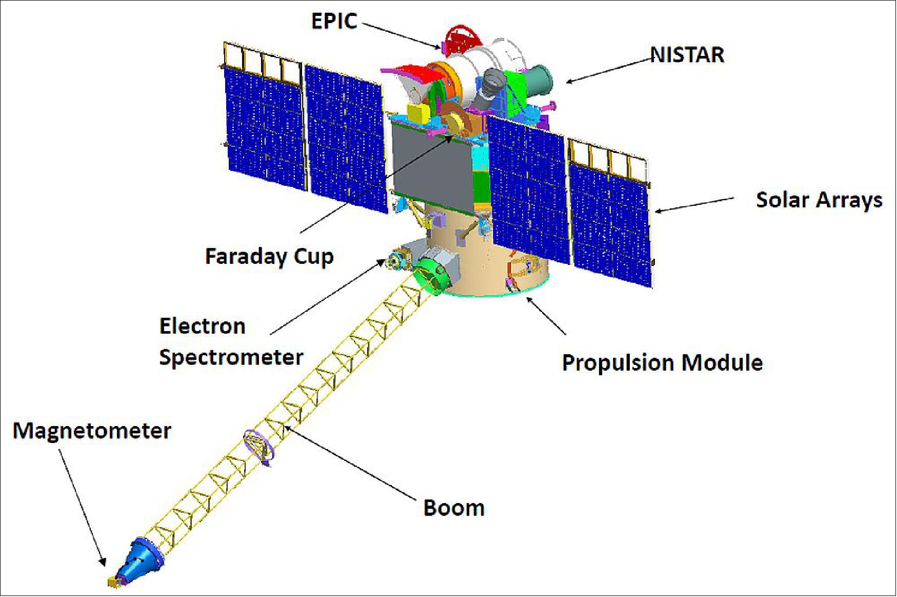
Figure 4: Sunward side of the deployed DSCOVR spacecraft (image credit: NASA)
Mission roles of the joint NOAA, NASA and USAF program
NASA Activities:
• Project management
• Refurbish spacecraft and solar wind sensors ; develop operating system
• Ship DSCOVR to launch site and arrange for payload processing
• Transfer DSCOVR after check out
NOAA Activities
• Program management
• Reimburse NASA for spacecraft refurbishment
• Operate spacecraft
• Plan follow-on service
• Process and archive data for geomagnetic storm warnings and issue timely alerts
USAF Activities
• Provide launch services, including mission assurance
Development Status
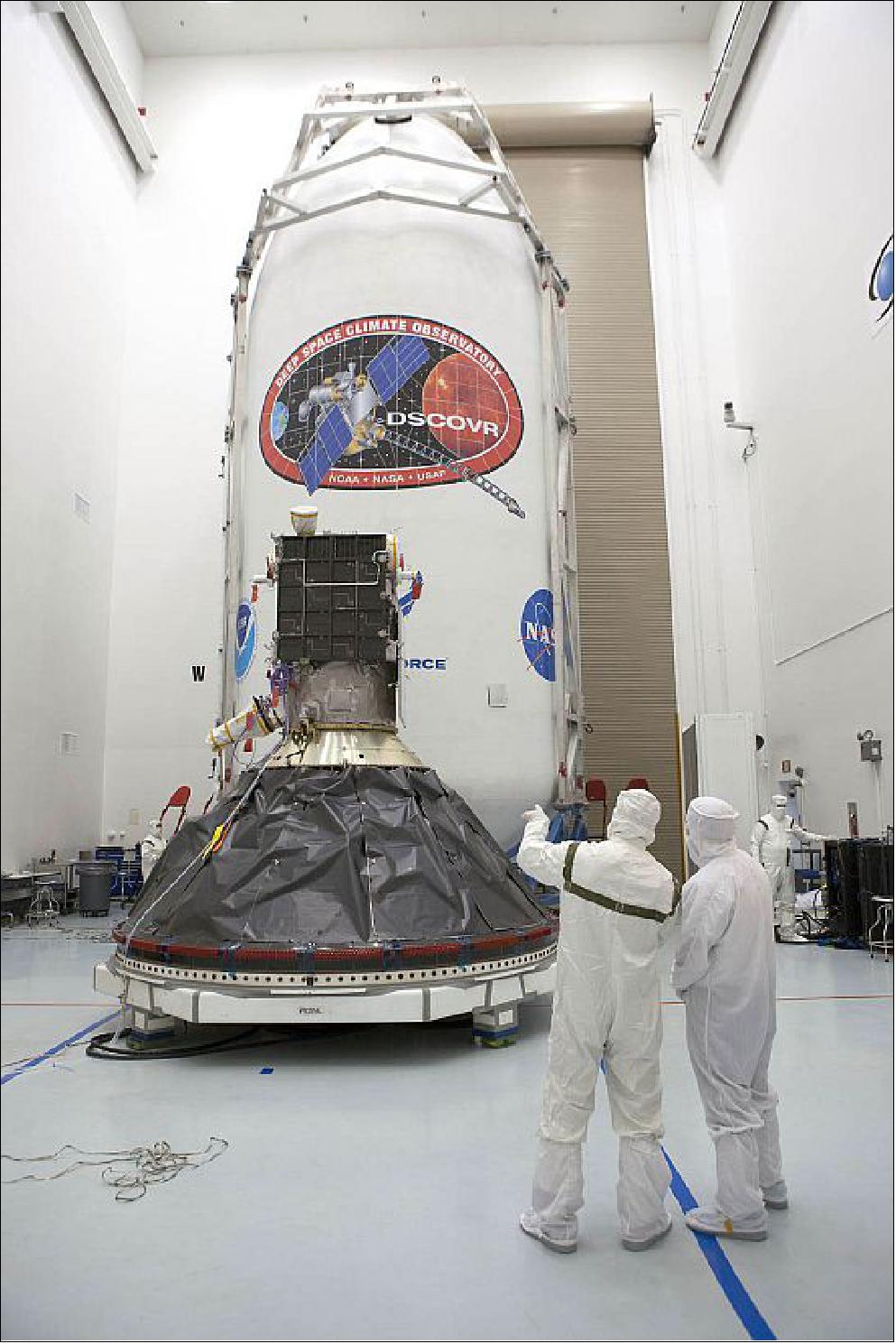
• Nov. 21, 2014: The DSCOVR spacecraft was transported by truck from NASA/GSFC in Maryland to an Astrotech satellite processing facility in Titusville, Fla., just outside the gates of Kennedy Space Center. 21)
• Status of DSCOVR project in May 2014:
- Spacecraft and Sensors are fully integrated
- Successfully completed Electromagnetic Interference & Compatibility (EMI/EMC), Mass Properties, Thermal Vacuum/Balance, Acoustics tests; Vibration testing is last major remaining environmental test.
- Observatory scheduled for October 2014 shipment to Launch site.
Launch
Launch: The DSCOVR spacecraft of NOAA was launched on February, 11, 2015 (23:03.02 UTC) on a Falcon-9 v1.1 vehicle of SpaceX from SLC40 (Space Launch Complex 40) of Cape Canaveral Air Force Station, FL. 22) 23) 24) 25)
The launch is sponsored by the USAF. In December 2012, the USAF awarded a contract to SpaceX to launch DSCOVR aboard a Falcon-9 vehicle. 26) 27)
Orbit: Lissajous orbit about L1, the first Lagrangian Point (L1) in the Earth-Sun system (1.5 million km from Earth in the direction of the Sun). DSCOVR will be on-station in 110 days.
Second attempt of SpaceX to recover the first stage of the Falcon-9 vehicle:
As the second stage embarks on its journey into the Solar System, the first stage will begin its return to Earth, marking the second attempt undertaken by SpaceX to land a first stage booster on the newly commissioned (ASDS (Autonomous Spaceport Drone Ship) - a 91 m x 52 m floating platform equipped with GPS systems and powerful azimuth thrusters to maintain a precise spot in the Atlantic Ocean that is also programmed into the first stage of Falcon-9. 29)
The first attempt to return the first stage came on the Dragon SpX-5 mission ( launch on January 10, 2015) after several previous attempts to soft-land first stages in the Ocean that demonstrated the overall architecture of the delicate return sequence. The SpX-5 first stage successfully made it through its high velocity burns occurring outside the atmosphere and during re-entry, and began atmospheric guidance using four grid fins to find its way back to the landing platform.
Recovery attempt cancelled:
Out in the Atlantic Ocean, the ASDS (Autonomous Spaceport Drone Ship) was on station, beginning a holding pattern in a precise position using its GPS system and powerful azimuth thrusters for stabilization to ensure it would be in the correct spot that was also programmed into the computers of the first stage of Falcon-9. Over the course of the day on Feb. 11, it became clear that the ASDS could not hold its position due to rough seas and one of the four azimuth thrusters used for stationkeeping being out of operation. 30) 31)
As a result, SpaceX opted to move the ASDS out of the landing zone and have the first stage make its landing attempt, pretending the Ocean was firm ground to land on - delivering more data on atmospheric flight and the targeting of a precise spot without endangering the landing platform. The ASDS and its support ship were in a safe position, tasked with recording telemetry from the Falcon-9 and receiving video and data from the drone ship.
SpaceX had to revert from a planned landing on ASDS to a soft splashdown attempt due to rough seas in the Atlantic that prevented the drone ship from keeping its position.
But the first stage of the Falcon-9 vehicle went through all the preprogrammed reentry maneuvers after separation:
Two minutes and 44 seconds after liftoff, the first stage shut down its nine Merlin 1D engines after fulfilling its primary objective of delivering the second stage to a trajectory from where it could boost DSCOVR to its L1 Transfer Orbit. This marked the longest burn of an F-9 first stage in a mission with either soft splashdown or ASDS landing attempt, driven by the injection target of the spacecraft requiring more performance than a Dragon mission into Low Earth Orbit.
With the second stage on its way, the first stage embarked on its journey back to Earth. Classed as a secondary objective, the soft splashdown of the first stage nevertheless was right in the center of attention as part of SpaceX's quest toward re-usability that will involve flying booster stages back to landing sites for refurbishment and re-use for a drastic reduction in the overall cost of space flight.
Heading back in, the first stage kept a stable posture with its engines pointing forward to make a short 19-second reentry burn once reaching 70 km in altitude. This burn slowed the vehicle down from over 1,200 m/s and provided shielding of the engine compartment to create protection from the most strenuous environments occurring at reentry.
Flying through the dense atmosphere, the first stage was to use the grid fins to maintain stable yaw and roll rates and control its pitch-trim to control the downrange travel distance and begin targeting the precise landing spot. The grid fins of the Falcon-9 made their debut on the SpX-5 mission and provided excellent guidance throughout the entire velocity regime from supersonic entry velocity, through the transonic transition and into subsonic speeds.
To avoid the grid fins running out of hydraulic fluid prior to landing like they did on their first flight, the system flew with a larger margin of hydraulic fluid. The four fins can be individually controlled in a two-degree of freedom type design, rotating and tilting at the same time, allowing for complex guidance and control during atmospheric flight.
Beginning its 28-second landing burn using its Center Engine alone, the Falcon-9 was to make last fine corrections of its flight path, ideally coming to a nearly vertical descent. Ten seconds prior to touchdown, the four landing legs were to deploy using pressurized Helium to extend the legs to their deployed position. Landing was planned to occur at a speed of less than 6 m/s under the power of the center engine creating a thrust to weight ratio greater than one.
Elon Musk tweeted that the first stage landed within 10 m of its target based on navigation data received from the booster that also showed that the stage was upright and had reached a good velocity for touchdown. Had the Autonomous Spaceport Drone Ship been in position in better weather conditions, the landing would have succeeded (Ref. 30).
Mission Status
• On December 4, 2021, a handful of people in Antarctica were treated to clear views of a total solar eclipse, the only one to occur in 2021. A partial eclipse was visible in other parts of the Southern Hemisphere. The eclipse reached totality at 07:44 Universal Time (UTC) and lasted just under 2 minutes, darkening the Antarctic summer skies at a time when the Sun is above the horizon for several months. 32)
- During a total solar eclipse, the Sun, Moon, and Earth line up in that order, with the Moon between the Sun and Earth. The Moon casts a shadow on part of Earth's surface. For those people located in the center of the Moon’s shadow, the Sun is either fully or partially blocked from view and the sky becomes very dark. Viewers with clear skies and the right equipment or eyewear can often observe the Sun’s outer atmosphere, or corona. Normally, it is obscured by the brightness of the Sun’s surface.

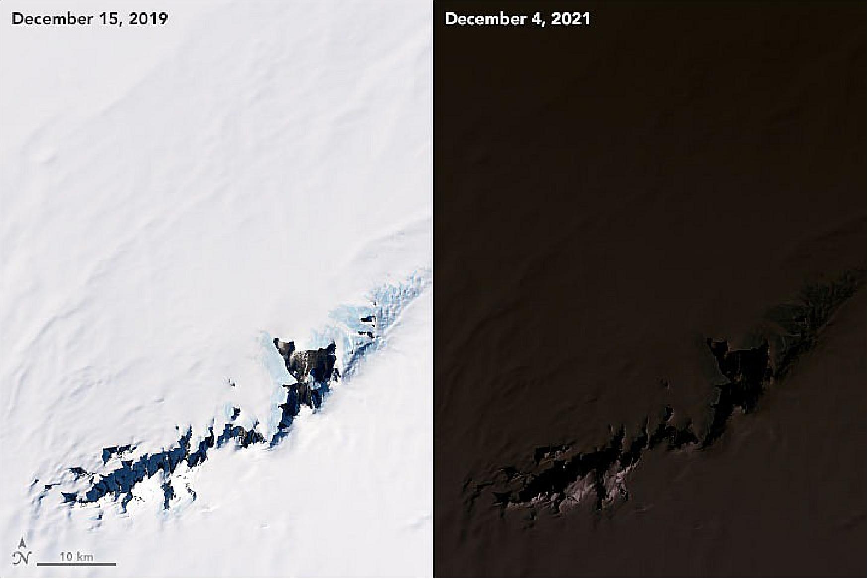
- Total solar eclipses in the polar regions are rare because they comprise less of Earth’s land area and because the Sun only lights each pole for part of the year. The last total solar eclipse in Antarctica occurred in November 2003. The next will occur in December 2039.
• October 2, 2021: Forecasters call for Hurricane Sam, a potent storm spinning over the Atlantic Ocean, to steer clear of land. But some areas are still likely to witness the effects of the storm, from high winds in Bermuda to dangerous waves and currents at beaches up and down the U.S. East Coast. 33)
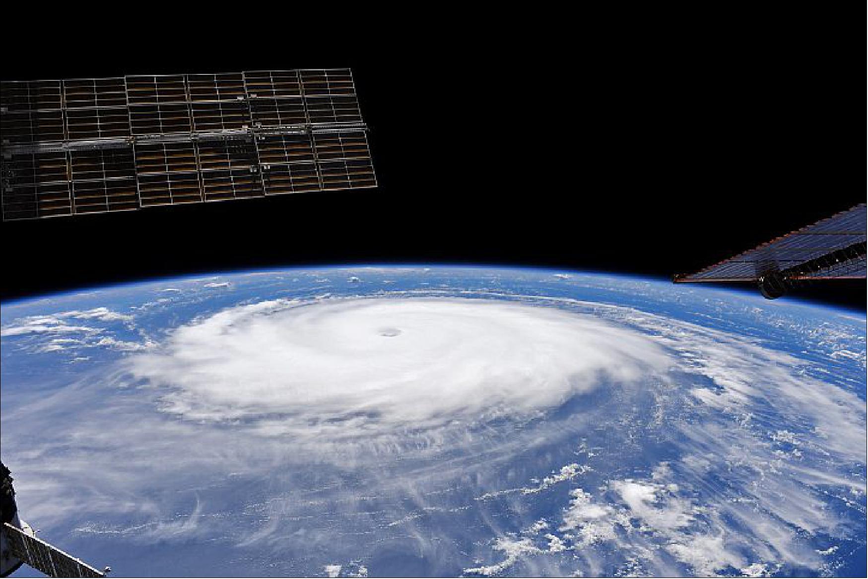

- The forecast track called for Sam to turn north and then northeast, with its center passing east of Bermuda and staying well away from the coast of the United States. Scott Braun, a scientist who specializes in hurricanes at NASA’s Goddard Space Flight Center, pointed out a frontal system responsible for pulling Sam toward the north, visible in the EPIC image. “The cold front extends from well north of Sam (in the north-northeast direction) to the west of Sam, as seen in the bright, but somewhat broken clouds along the front.”
- The image of Figure 11 also shows that Sam is not alone. Tropical Storm Victor was located about 1,000 km southwest of the Cabo Verde islands and moving toward the west-northwest. Winds in this storm were much weaker, holding steady at 75 kilometers (45 miles) per hour. Forecasts call for Victor to remain a tropical storm for a few days and then weaken into a tropical depression.
- Strong wind shear, which can tear apart a storm’s organization, is one reason why Victor is expected to weaken. The storm is also trailing a plume of Saharan dust blowing west from North Africa. Such dust outbreaks tend to be accompanied by dry air, which can weaken or even stop a storm.
- “The dust that is clearly visible northwest of Victor will move by to the west and Victor will move northward behind it,” Braun said. “Another dust outbreak coming off of Africa will approach Victor from the east and the dry air associated with it, combined with the strong vertical wind shear, is likely to weaken the storm over the next several days.”
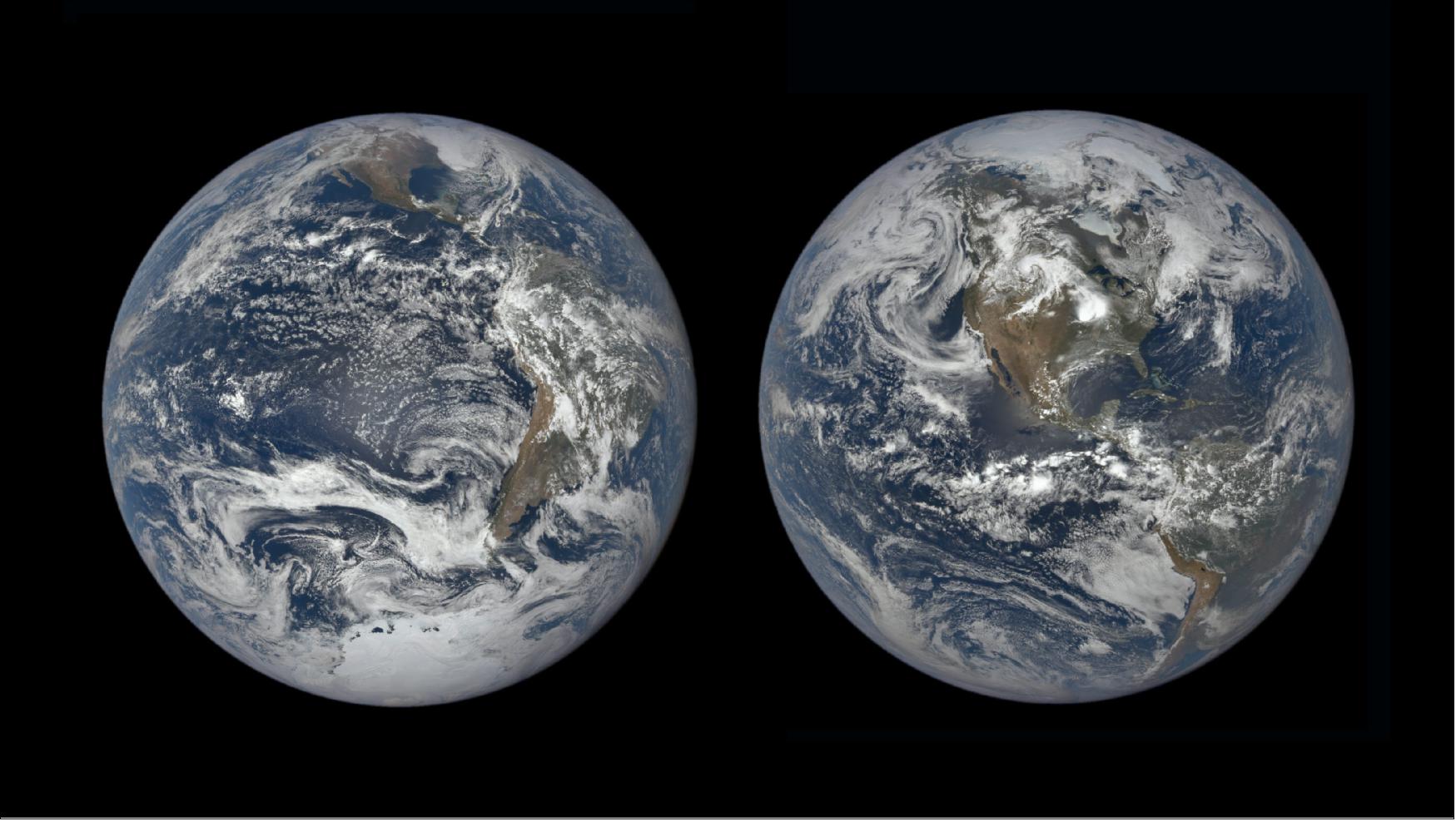
• June 18, 2021:Earth orbits at an angle, so half the year, the Northern Hemisphere is tilted toward the Sun — this is summer in the Northern Hemisphere, and winter in the Southern Hemisphere. The other half of the year, the Northern Hemisphere is tilted away from the Sun, creating winter in the north and summer in the south. 34)
- Solstices happen twice per year, at the points in Earth’s orbit where this tilt is most pronounced. These days are the longest (in the summer hemisphere) and shortest (in the winter hemisphere) of the year, and mark the change of seasons to summer and winter, respectively.
- June 20, 2021, marks the summer solstice — the beginning of astronomical summer — in the Northern Hemisphere.
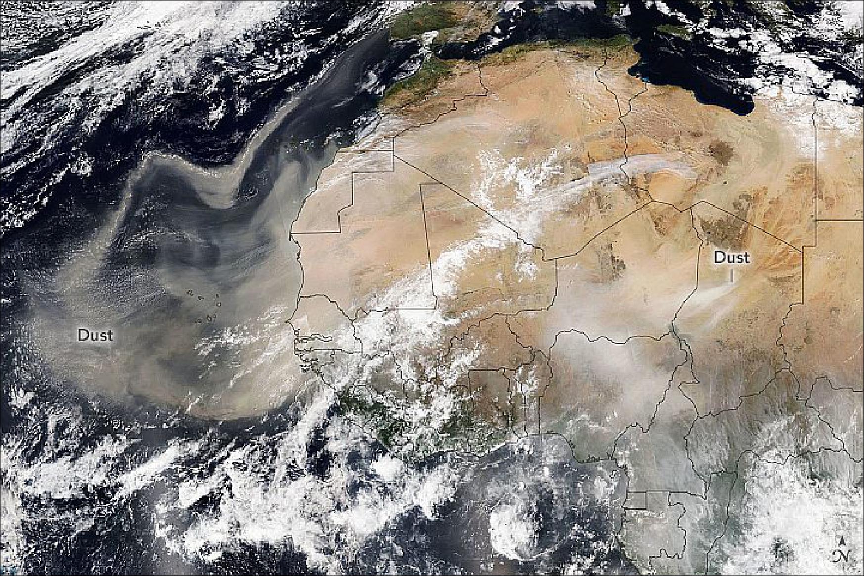
• February 20, 2021: Each year more than 180 million tons of dust blow out from North Africa, lofted out of the Sahara Desert by strong seasonal winds. Perhaps most familiar are the huge, showy plumes that advance across the tropical Atlantic Ocean toward the Americas. But the dust goes elsewhere, too—settling back down in other parts of Africa or drifting north toward Europe. 35)
- While much of the plume appears west of Africa, a tendril of dust can be seen riding the winds toward Europe. According to a story by research meteorologist Marshall Shepherd, strong and persistent winds from the south drive Saharan dust toward Europe at least a few times a year.
- Forecasts from the Copernicus Atmosphere Monitoring Service indicated that most of the dust reaching Europe this weekend will likely be concentrated over Spain and France, but some may carry as far north as Norway. Parts of Spain might see “mud rain,” as the approaching dust plume combines with a weather front.
- The mid-February dust storm follows an intense event earlier in the month over southern and central Europe. Saharan dust from that storm coated the snow on the Pyrenees and Alps and turned skies orange in France.
- Dust can degrade air quality and accelerate the melting of snow cover. But it also plays a major role in Earth’s climate and biological systems, absorbing and reflecting solar energy and fertilizing ocean ecosystems with iron and other minerals that plants and phytoplankton need to grow.
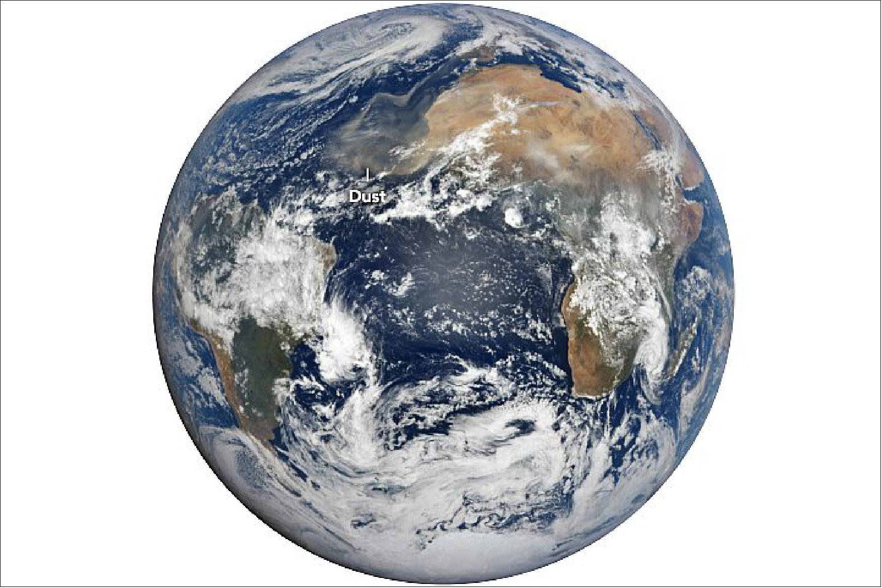
• June 20, 2020: Every year, winds loft about 800 million metric tons of desert dust from North Africa—by far the planet’s largest source of airborne dust particles. The dust is often visible from space during the spring, summer, and early fall, when huge plumes of dry, dusty air from the Sahara Desert (the Saharan Air Layer) blow westward over the tropical Atlantic Ocean. 36)

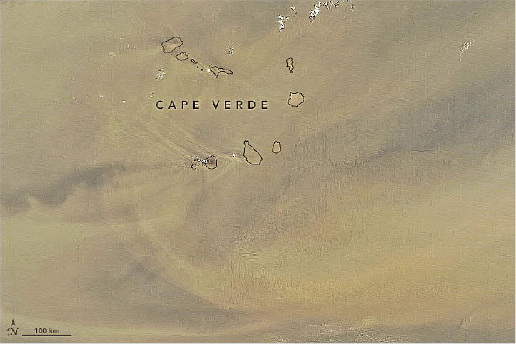
- Summer typically brings a larger volume of dust over the islands, but it also tends to be float higher in the atmosphere than in other seasons. Still, the volcanic peaks are high enough to alter the air flow and produce patterns in the dust. Notice the v-shaped pattern on the leeward side of the islands. The phenomenon is similar to the v-shaped wake you see behind a boat in a lake or a rock in a stream.
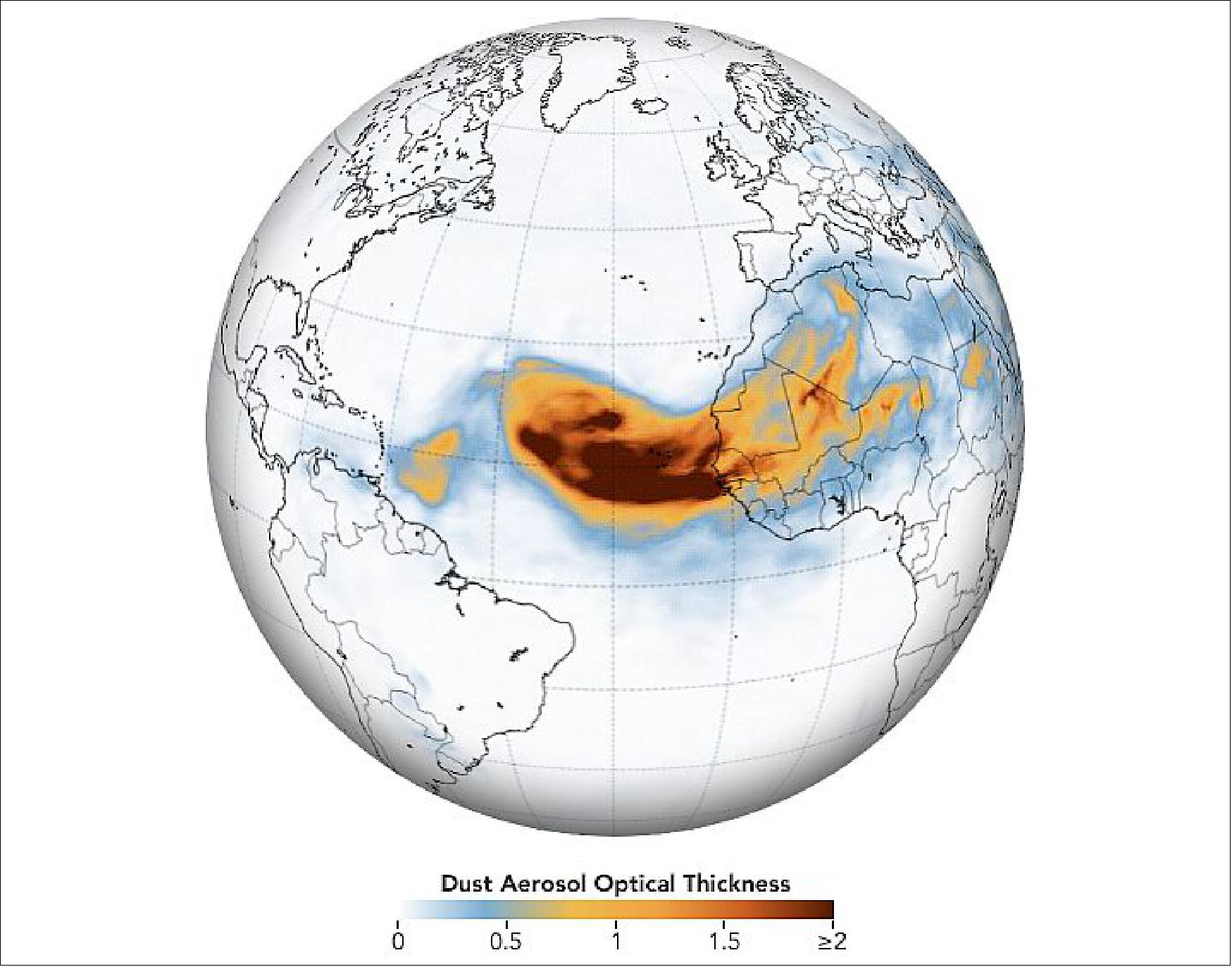
- The thickest parts of the plume appear to stretching about 2,500 km across the Atlantic. Forecasts indicate that the dust could reach the Caribbean by June 20, and then later drift over the contiguous United States.
- Dust from Africa can affect air quality as far away as North and South America if it is mixed into the air near the ground. But the dust plays an important ecological role, such as fertilizing soils in the Amazon and building beaches in the Caribbean. The dry, warm, and windy conditions associated with Saharan Air Layer outbreaks can also suppress the formation and intensification of tropical cyclones.
• March 20, 2020: It has been a tough month on Earth. Good news has been scarce. But here’s at least one update — from one million miles away — to appreciate. 37)
- The DSCOVR satellite, which had been out of commission for about nine months due to a technical problem, is fully operational again, according to NOAA. Issues with the satellite’s attitude control system prompted engineers to put the satellite into a “safe hold” in June 2019, but they recently developed a software fix for the problem.
- The EPIC view is a potent reminder of something that Frank White, author of The Overview Effect, said recently on a NASA podcast. (The book explores how seeing Earth from space causes many astronauts to dramatically change their outlook on our planet and life itself.)
- “[One of the] conclusions they draw is that we are really all in this together,” he said. “Our fate is bound up with people that we may think are really different from [us]. We may have different religions, we may have different politics. But ultimately, we are connected. Totally connected.”

• March 2, 2020: NOAA's Deep Space Climate Observatory (DSCOVR) satellite, which had been offline for about nine months due to a technical glitch, is fully operational again, agency experts said today. 38)
- On June 27, 2019, issues with the satellite’s attitude control system prompted engineers to place DSCOVR into a “safe hold.” That maneuver halted the flow of all science observations, including imagery from NASA's Earth Polychromatic Imaging Camera (EPIC). The high-powered camera takes full-disk images of the Earth used for global monitoring of clouds and vegetation, as well as atmospheric ozone and aerosols.
- NOAA and NASA engineers developed a flight software patch to restore DSCOVR's operations.
- "Bringing DSCOVR operational again shows the unique skills and adaptability of our NOAA and NASA engineers and the care we are taking to get the maximum life from an aging asset," said Steve Volz, Ph.D., assistant NOAA administrator for its Satellite and Information Service.
- While DSCOVR was out of service, NOAA's Space Weather Prediction Center (SWPC) received critical space weather observations from NASA’s ACE (Advanced Composition Explorer) and continued to issue space weather alerts, watches and warnings.
- When it launched on Feb. 11, 2015, DSCOVR was America's first operational satellite in deep space, orbiting about a million miles from Earth. It is the Nation's primary monitor of real-time solar wind data and a warning system for solar magnetic storms that could threaten electrical grids, disrupt communication systems and the Global Positioning System navigation, reroute air travel, affect satellite operations and endanger human spaceflight.
- DSCOVR is a partnership between NOAA, NASA and the U.S. Air Force. NOAA operates DSCOVR from its Satellite Operations Facility in Suitland, Maryland, and processes the space weather data at NOAA's Space Weather Prediction Center (SWPC) in Boulder, Colorado. From there, SWPC distributes the DSCOVR data to users within the United States and around the world. NASA Goddard processes the Earth science data and makes it publicly available.
• July 5, 2019: A joint NASA/NOAA spacecraft that monitors space weather and provides imagery of Earth has been offline for more than a week because of a problem with its positioning system. 39)
- The DSCOVR (Deep Space Climate Observatory) spacecraft went into a “safehold”on 27 June, interrupting its science observations from its perch at the Earth-Sun L-1 Lagrange point, 1.5 million kilometers from the Earth in the direction of the sun.
- NOAA spokesman John Leslie said July 5 that engineers placed the spacecraft into safehold to “first diagnose and then work to fix a technical issue in the system that maintains the satellite’s position.” While that work is underway, he said, the spacecraft is not returning data.
- The primary mission of DSCOVR, launched in February 2015, is to monitor solar wind conditions, providing advance notice of space weather events. While DSCOVR is in safehold, Leslie said NOAA’s Space Weather Prediction Center will instead rely on data from the ACE (Advanced Composition Explorer) and the SOHO (Solar and Heliophysic Observatory) spacecraft, which, like DSCOVR, are at the Earth-sun L-1 point, as well as instruments on weather satellites in geostationary Earth orbit.
- DSCOVR has suffered a number of safeholds in the past, but those typically have lasted only a matter of hours. Engineers speculated that those earlier safeholds were caused by cosmic ray hits on spacecraft electronics. Leslie didn’t give a timetable for resuming normal operations of DSCOVR.
- While DSCOVR’s primary mission is space weather monitoring, the spacecraft is perhaps best known for an Earth-facing camera called EPIC (Earth Polychromatic Imaging Camera). That camera takes full-disk images of the Earth that can be used for global monitoring of atmospheric ozone and aerosols, as well as clouds and vegetation.
- EPIC dates back to the original mission for DSCOVR more than 20 years ago. NASA proposed the mission, then called Triana, at the request of Vice President Al Gore to provide that full view of the Earth. The mission was put on hold early in the administration of President George W. Bush, with the spacecraft put into storage. The Obama administration resurrected the mission under the DSCOVR name and with a new emphasis on space weather monitoring.
- The Trump administration, though, proposed terminating EPIC operations. Its NASA budget requests for fiscal years 2018 and 2019 included no funding for EPIC, proposals that did not affect the overall DSCOVR mission, funded by NOAA. Congress rejected those proposals, explicitly including funding for DSCOVR operations in their final appropriations bills.
- NASA did not repeat that effort to end funding of DSCOVR in its fiscal year 2020 budget request. The agency’s budget proposal sought $1.7 million for DSCOVR operations, the same amount it received in 2018.
• June 4, 2019: Smoke from several large wildfires in Canada was so thick and widespread that it was easily visible from 1.5 million kilometers away from Earth. NASA’s EPIC (Earth Polychromatic Imaging Camera) on NOAA’s DSCOVR satellite acquired this image on May 30, 2019, when a river of smoke was streaming east across Alberta, Saskatchewan, and Manitoba. 40)
- One of the largest sources of smoke was the Chuckegg Creek wildfire. Though it has been burning since May 12, 2019, unusually gusty winds and dry conditions triggered rapid growth on May 29, forcing authorities to issue evacuation orders for 10,000 people. On May 31, the provincial government noted that nine other fires were burning out of control, five were “being held” (not likely to grow past expected boundaries), and ten were under control.
- The intense burning fueled pyrocumulus clouds, which lofted smoke high into the atmosphere and allowed high-level, fast-moving winds to transport it long distances. According to a special air quality advisory issued by Environment Canada on May 31, people in parts of northern, central, and southern Alberta faced poor air quality and reduced visibility. “Individuals may experience symptoms such as increased coughing, throat irritation, headaches, or shortness of breath. Children, seniors, and those with cardiovascular or lung disease, such as asthma, are especially at risk,” the agency noted.
- With elevated concentrations of particulate matter in the smoky air across much of Alberta, citizens encountered gloomy, reddish skies. “In Edmonton, it looked like we were on Mars,” said Matt Albers of the Meteorological Service of Canada.

• November 8, 2018: A NASA camera observing the sunlit side of Earth from a million miles away is providing new data on daily changes to our planet. 41)
- The EPIC instrument operates aboard the National Oceanic and Atmospheric Administration’s (NOAA) Deep Space Climate Observatory (DSCOVR) satellite, which launched in February 2015 and observes Earth from a distance of about one million miles toward the Sun, allowing for observation of the entire Earth from sunrise to sunset.
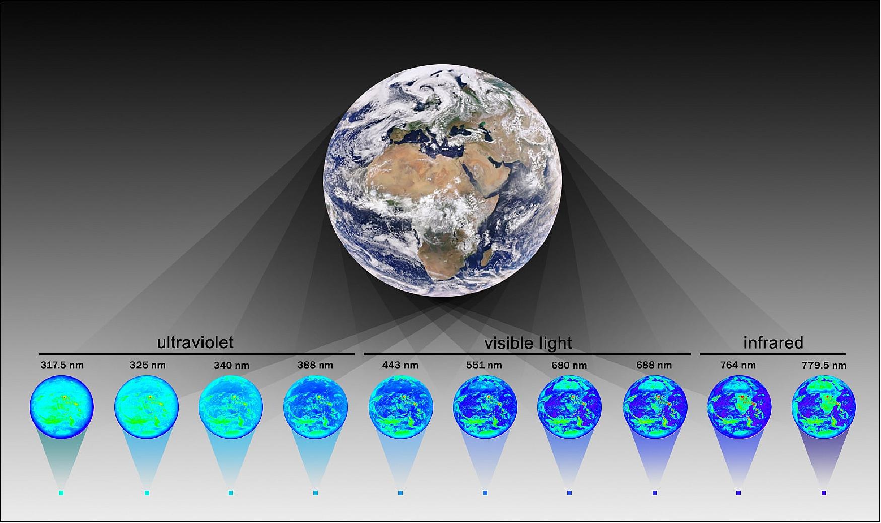
- A spectroradiometer, EPIC acquires images using 10 filters that detect light covering a wavelength region from the ultraviolet to the near-infrared. NASA has made publicly available daily color images that the instrument has been capturing of the sunlit Earth since June of 2015, and now following suit are a collection of science products: sulfur dioxide from volcanic eruptions, total column ozone, ultraviolet (UV) aerosols, cloud and vegetation properties and atmospheric correction including surface reflectance. Those data are available from June 2015 to about two days before the current date.
- NASA’s existing fleet of Earth-orbiting satellites provides observations of those and other quantities, enabling scientific research on how the planet is changing. The newly available EPIC products will complement those observations because of the instrument’s ability to capture more images of the entire planet during daylight than any instrument on NASA’s other satellites. In the summer, EPIC captures on average one image every hour and one image every two hours during winter.
- “Given EPIC’s special vantage point and frequent observations, we are able to observe the daytime portion of the daily cycle of many phenomena,” said NASA’s Alexander Marshak, deputy project scientist for the DSCOVR mission at NASA's Goddard Space Flight Center in Greenbelt, Maryland. “For example, EPIC can follow a volcanic eruption or a fire plume during the entire day. These measurements complement those taken by other low Earth-orbiting satellites, which view a particular location less often, in many cases only once or twice per day.”
- The UV aerosol product tracks phenomena such as plumes from wildfires as they travel hundreds and sometimes thousands of miles and impact everything from air quality to precipitation. Likewise, the sulfur dioxide product tracks volcanic emissions, which can affect air quality and air transportation around the globe, while the ozone product monitors concentrations of this UV-absorbing gas—important to both plant and animal life.
- The vegetation product provides information related to plant health and canopy coverage. The Normalized Difference Vegetation Index (NDVI) measures the concentration of chlorophyll in leaves, which is indicative of plant stress and vitality, as plants need chlorophyll to convert energy from the Sun into nutrients. The Leaf Area Index (LAI) projects the amount of leaves over a given area and is important for estimating canopy cover for forest and other studies. While other remote sensing instruments also provide data on NDVI and LAI, EPIC is the first to provide the Sunlit Leaf Area Index (SLAI). “Both LAI and SLAI are key parameters in many global climate, hydrology and ecology models,” Marshak said.
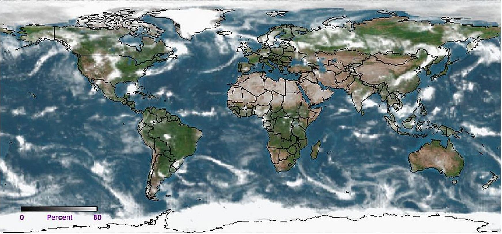
- The cloud dataset provides a number of details, including cloud height and thickness, which are important for climate studies and weather analysis and can complement data from other remote sensing spacecraft. Geostationary satellites, such as the GOES-16 spacecraft operated by NOAA, can also observe clouds throughout the day but cannot capture much of the areas near the North and South Poles. But EPIC’s unique positioning in space allows the instrument to capture the Arctic Circle in the northern hemisphere summer and Antarctica during the northern hemisphere winter.
- The atmospheric correction dataset provides quantitative information about the amounts of aerosols in the atmospheric column, and it also removes the effects of atmospheric absorption and the scattering of sunlight, providing images of Earth’s surface as if observed without the atmosphere.
- The EPIC instrument is one of a suite of instruments housed aboard the DSCOVR satellite. The primary objective of the DSCOVR mission, a partnership between NASA, NOAA and the U.S. Air Force, is to maintain the nation’s real-time solar wind monitoring capabilities, which are critical to the accuracy and lead time of space weather alerts and forecasts from NOAA. The DSCOVR mission was planned as a two-year mission with fuel to last five years.

• June 28, 2018: The study of exoplanets — planets that lie outside our solar system — could help scientists answer big questions about our place in the universe, and whether life exists beyond Earth. But, these distant worlds are extremely faint and difficult to image directly. A new study uses Earth as a stand-in for an exoplanet, and shows that even with very little light — as little as one pixel — it is still possible to measure key characteristics of distant worlds. 42)
- The new study uses data from NASA's Earth Polychromatic Imaging Camera (EPIC) instrument, which is onboard the National Oceanic and Atmospheric Administration's DSCOVR (Deep Space Climate Observatory) satellite. DSCOVR goes around the Sun at Lagrange point 1, a specific orbit that provides EPIC with a constant view of our home planet's sunlit surface. EPIC has been observing Earth continuously since June 2015, producing nuanced maps of the planet's surface in multiple wavelengths, and contributing to studies of climate and weather.
- The EPIC instrument captures reflected light from Earth in 10 different wavelengths, or colors. So, each time EPIC "takes a picture" of Earth, it actually captures 10 images. The new study averages each image into a single brightness value, or the equivalent of one "single-pixel" image for each wavelength. A single, one-pixel snapshot of the planet would provide very little information about the surface. But in the new study, the authors analyzed a data set containing single-pixel images taken multiple times per day, in 10 wavelengths, over an extended period. Despite the fact that the entire planet had been reduced to a single point of light, the authors were able to identify water clouds in the atmosphere and measure the planet's rotation rate (the length of its day). The authors say the study, in the June 27 issue of the Astrophysical Journal, demonstrates that the same information could be derived from single-pixel observations of exoplanets.
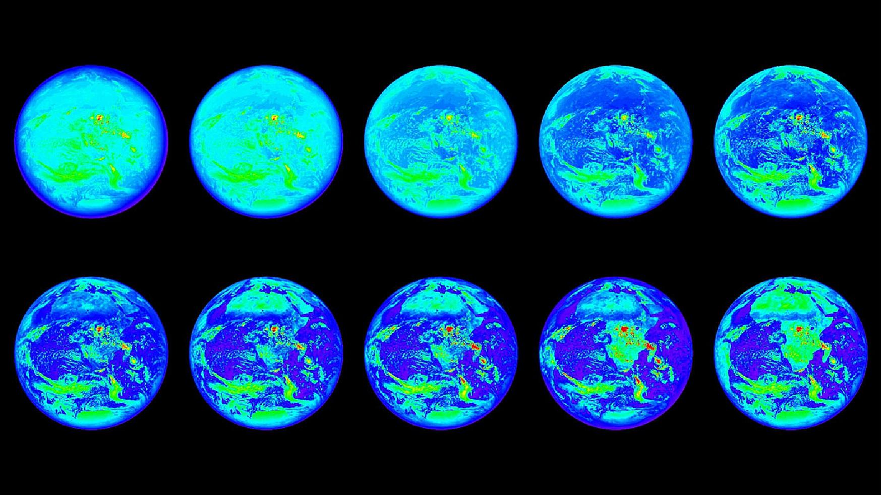
- "The benefit of using Earth as a proxy for an exoplanet is that we can verify our conclusions derived from the single-pixel data with the wealth of data that we actually have for Earth — we can't do that if we're using data from a distant, actual exoplanet," said Jonathan Jiang, an atmospheric and climate scientist at NASA's Jet Propulsion Laboratory in Pasadena, California, and lead author on the new study. 43)
- When Jiang's daughter, Teresa, was in elementary school, he organized a star-observing event for her and her friends. Jiang pointed to the stars, and told his daughter that the Sun is also star, and that there are planets orbiting other stars just as planets orbit the Sun. She pressed her father for more information, asking how scientists could possibly learn about those distant worlds from such tiny points of light in the sky.
- "Kids ask a lot of good questions," Jiang said. "And that question stuck in my mind — if I can see an exoplanet as only a tiny point of light, can I see clouds and oceans and land?"
- Jiang began his career in astrophysics, but for his PhD work, he decided to apply his computer and physical modeling skills to Earth's climate. Now, he's using climate data to assist the study of exoplanets. Exoplanets are significantly dimmer than stars and much more difficult to detect. Earth, for example, is about 10 billion times fainter than the Sun. Only about 45 exoplanets have been discovered by direct imaging, all of which are much larger than Earth. The majority of known exoplanets (over 3,700 have been confirmed) were detected indirectly, using techniques such as the transit method, in which scientists observe the slight dimming of a star caused by the transit of an exoplanet across the face of the star.
- The EPIC instrument captures reflected light from the sunlit side of Earth in 10 different wavelengths, or colors, because different materials reflect different wavelengths of light to different degrees — plants, for example, reflect mostly green light. And a reddish planet like Mars, for example, would have a very different color profile compared to a planet covered in ice.
- The new study shows that by observing a planet with distinct features over time — such as oceans and continents — it is possible to measure the planet's rotation rate by observing a repeating pattern in the reflected light. This pattern would arise from those planetary features moving into view with a regular cadence. For example, every 24 hours, Australia and the Pacific Ocean fills EPIC's field of view, and about 12 hours later South America and the Atlantic fill the frame, with Africa and the Indian Ocean passing by in between. This pattern of changing light would repeat day after day. In the new paper, the authors show that they can detect this repeating cycle and thus determine the rotation rate, or the length of the planet's day. The rotation rate of a planet can reveal information about how and when the planet formed, and is a particularly difficult property to measure with current methods.
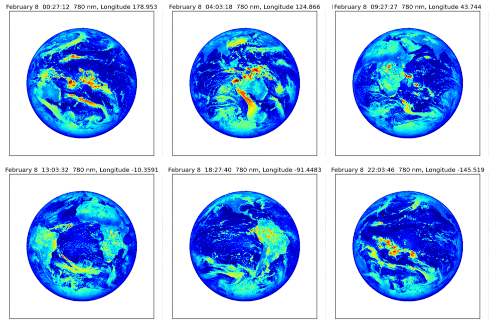
- "People have been talking for some time about using this approach to measure the rotation rate of exoplanets, but there's been no demonstration that it could work because we didn't have any real data," said Renyu Hu, an exoplanet scientist at JPL and a coauthor on the new study. "We've shown that in every wavelength, the 24-hour period appears, which means this approach to measuring planet rotation is robust."
- The authors note, however, that the effectiveness of this method would depend on the unique features of the planet. A daily-cycle pattern might not be visible on a planet that is largely homogenous over its surface. Venus, for example, is covered in thick clouds and has no oceans on its surface, so a recurring daylong pattern might not appear, or might not be distinct enough to observe in a one-pixel image. Planets like Mercury and Mars would also be challenging, but Jiang said planetary features like craters could also contribute to a pattern that could be used to measure the rotation period.
- Imaging exoplanets: Previous studies used Earth as a proxy for exoplanets, to investigate what kinds of planetary properties could be derived from afar, but no previous studies looked at so many wavelength bands. This is also the first such study to capture such a large data set, taken over an extended period of time: it used more than 27 months of observations, with images taken by EPIC about 13 times per day.
- Direct observations of exoplanets have far less data than what was used in the new study, but the researchers report that to measure the rotation rate of an exoplanet with more than 90 percent confidence would require taking images only two to three times per orbital period (that is, per "day" on that particular exoplanet) for about seven orbital periods.
- The amount of time astronomers would have to observe an exoplanet to identify its rotation rate also depends on how much unwanted light is included in the exoplanet data. The EPIC data provide an exceptionally clear view of Earth, largely unfettered by light from other sources. But one primary challenge in directly imaging exoplanets is that they are so much dimmer than their parent stars. The light from the nearby star can easily drown out the light from an exoplanet, rendering the latter invisible. With the signal from the planet competing with light from the star, it may take longer to discern a pattern that could reveal the planet's rotation rate. NASA is investigating potential designs for next-generation telescopes that might be able to directly image Earth-size exoplanets.
- With the field of exoplanet direct imaging moving ahead, Jiang is not done thinking about the question his daughter asked him more than a decade ago. If scientists can learn about the surface features of distant planets, then could they answer an even bigger question that his daughter posed — do any of those planets host life?
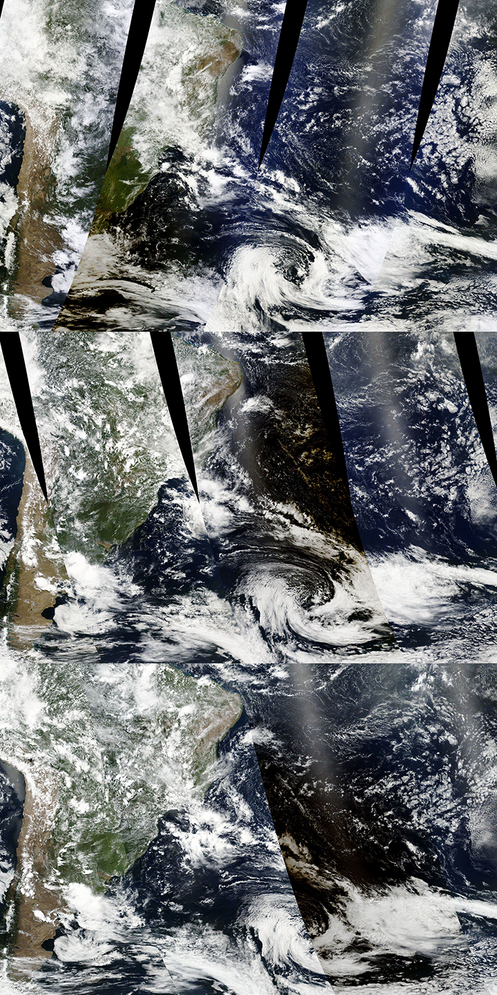
• August 23, 2017: On August 21, 2017, millions of Americans saw day turn temporarily to night as the Moon passed between the Sun and the Earth to create a total solar eclipse. As people in the 110 km wide path of totality looked up and saw blinding light replaced by a dark circle and the Sun’s wispy corona, several Earth-observing satellites captured spectacular imagery of the Moon’s shadow as it raced eastward over the continental United States. 44)

- From a closer vantage point, sensors on the polar-orbiting Terra and Suomi NPP satellites gathered data and imagery in swaths thousands of miles wide. The MODIS (Moderate Resolution Imaging Spectroradiometer) sensor on Terra and VIIRS (Visible Infrared Imaging Radiometer Suite) on Suomi NPP captured the data used to make the second image, an animation that alternates between two mosaics. Each mosaic is made with data from different overpasses that was collected at different times.
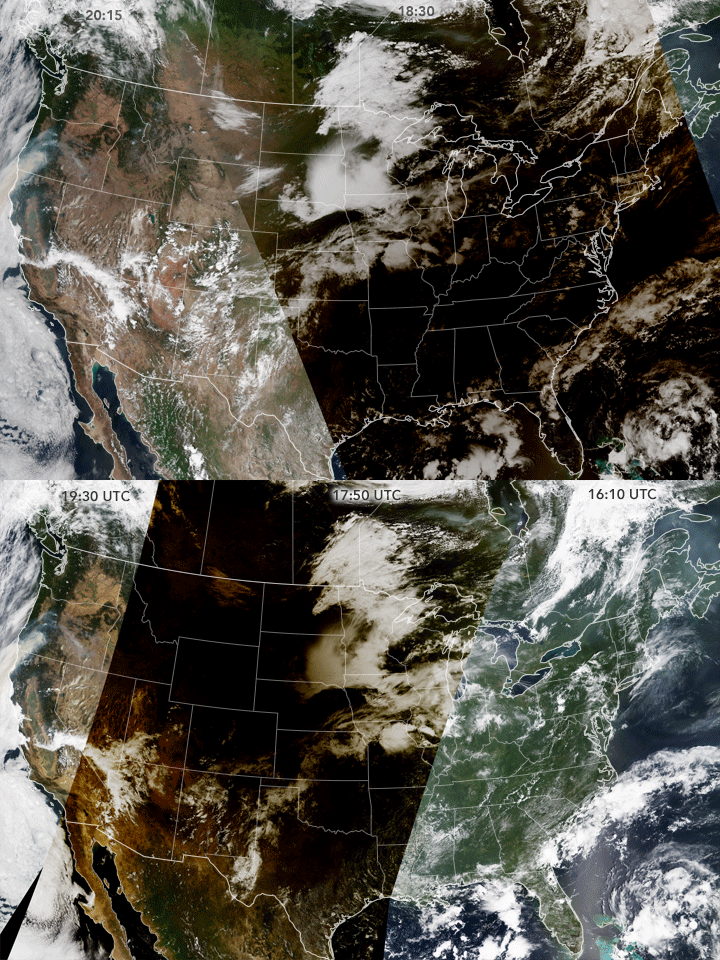
- The right third of the MODIS mosaic shows the eastern United States at about 12:10 p.m. Eastern Time (16:10 Universal Time), before the eclipse had begun. The middle part was captured at about 12:50 p.m. Central Time (17:50 Universal Time), when the eclipse was in progress in the center of the country. The left third of the image was collected at about 12:30 p.m. Pacific Time (19:30 Universal Time), after the eclipse had ended. The VIIRS mosaic is similar, but it shows the shadow at 2:30 p.m. Eastern Time (18:30 Universal Time), when it had reached the eastern United States. Note that VIIRS has a different orbital geometry and a slightly wider swath than MODIS.
• May 15, 2017: The EPIC (Earth Polychromatic Imaging Camera) instrument on DSCOVR is capturing hundreds of unexpected flashes over the span of a year. As keen observers from outside NASA wrote in, questioning the source of these lights, scientists deciphered the tiny cause to the big reflections: high-altitude, horizontally oriented ice crystals. 45)
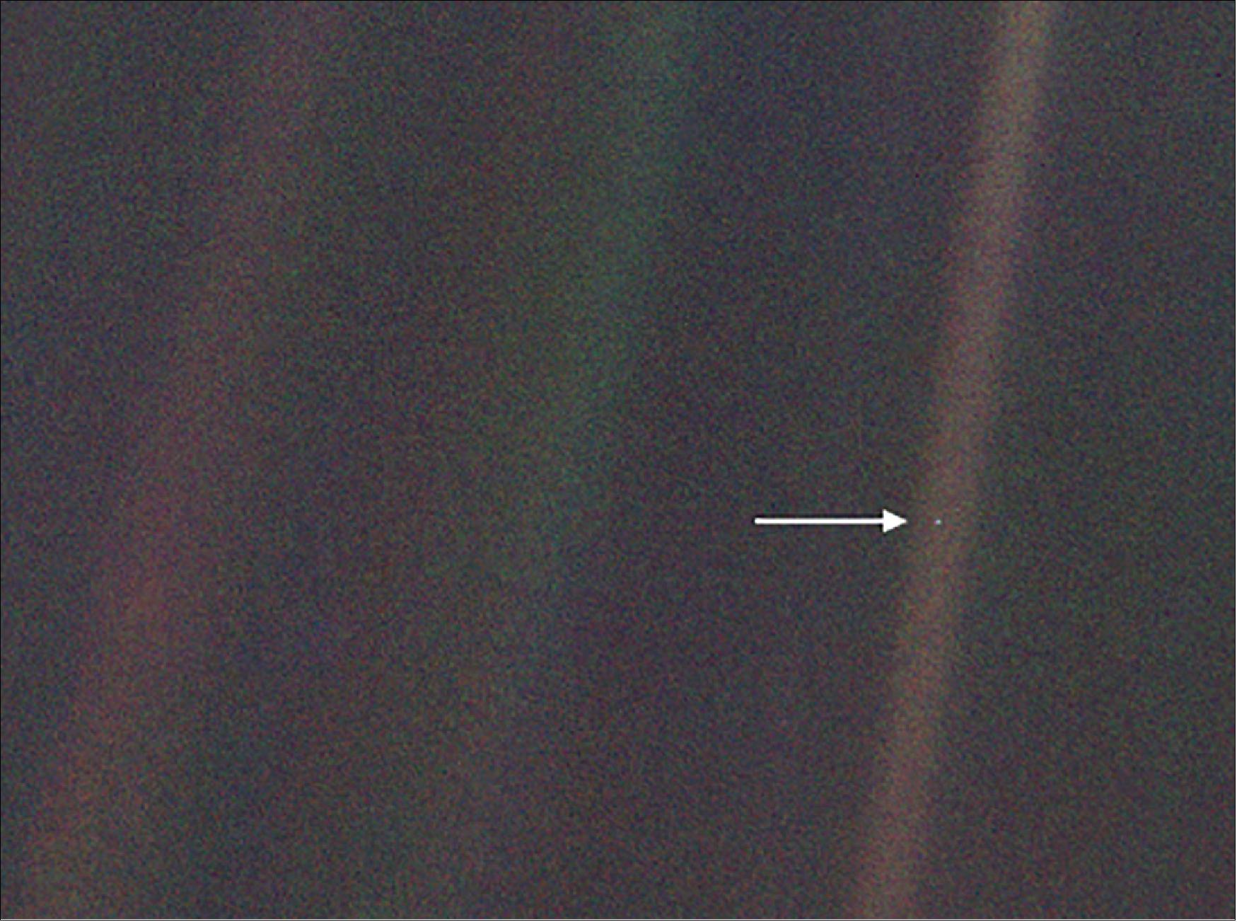
- Alexander Marshak, DSCOVR deputy project scientist at NASA’s Goddard Space Flight Center in Greenbelt, Maryland, first noticed light flashes occasionally appearing over oceans as he looked through that day’s EPIC images. Investigating the flashes, Marshak and his colleagues found that similar reflections from our pale blue dot caught the attention of astronomer Carl Sagan in 1993. Sagan was looking at images taken by the Galileo spacecraft, which launched in 1989 to study Jupiter and its moons. During one if its gravitational-assist swings around Earth, Galileo turned its instruments on this planet and collected data. Sagan and his colleagues used that to test a key question: Whether spacecraft could detect signatures of life from afar.
- Flashes of light reflected off oceans – like those referenced by Sagan – could have a simple explanation, Marshak said: Sunlight hits a smooth part of an ocean or lake, and reflects directly back to the sensor, like taking a flash-picture in a mirror.
- But when the scientists took another took a look at the Galileo images, they saw something Sagan and his colleagues apparently missed — bright flashes of light over land as well. And those flashes appeared in the EPIC images as well. As the contact listed on the website that posts all EPIC images, Marshak started getting emails from people curious about what the flashes were. “We found quite a few very bright flashes over land as well,” he said. “When I first saw it I thought maybe there was some water there, or a lake the sun reflects off of. But the glint is pretty big, so it wasn’t that.”
- Instead, he and his colleagues Tamas Varnai of the University of Maryland, Baltimore County, and Alexander Kostinski of Michigan Technological University, thought of water elsewhere in the Earth system: ice particles high in the atmosphere. The scientists conducted a series of experiments, detailed in a new paper published in Geophysical Research Letters, to confirm the cause of the distant flashes. 46)
- First, the researchers cataloged all of the prospective sunlight glints over land in images from the EPIC camera. The flashes show up in three distinct colors because the camera takes the red, green and blue images several minutes apart. In all, the scientists found 866 bursts between DSCOVR’s launch in June 2015 and August 2016.
- The scientists reasoned that if these 866 flashes were caused by reflected sunlight, they would be limited to certain spots on the globe – spots where the angle between the sun and Earth is the same as the angle between the spacecraft and Earth, allowing for the spacecraft to pick up the reflected light. When they plotted the locations of the glints with where those angles would match, given Earth’s tilt and the spacecraft’s location, the two matched. -This helped confirm that it wasn’t something like lightning causing the flashes, Marshak said: “Lightning doesn’t care about the sun and EPIC’s location.” The researchers also plotted angles to determine that the light was reflecting off of ice particles floating in the air nearly horizontally.
- Another feature of the EPIC data helped confirm that the flashes were from a high altitude, not simply water on the ground. Two channels on the instrument are designed to measure the height of clouds, and when the scientists went to the data they found high cirrus clouds, 5 to 8 kilometers where the glints were located. “The source of the flashes is definitely not on the ground. It’s definitely ice, and most likely solar reflection off of horizontally oriented particles,” Marshak said.
- Detecting glints like this from much farther away than in this case could be used by other spacecraft to study exoplanets, he said. As an Earth scientist, however, Marshak is now investigating how common these horizontal ice particles are, and whether they’re common enough to have a measurable impact on how much sunlight passes through the atmosphere. If so, it’s a feature that could be incorporated into computer models of how much heat is reaching and leaving Earth.
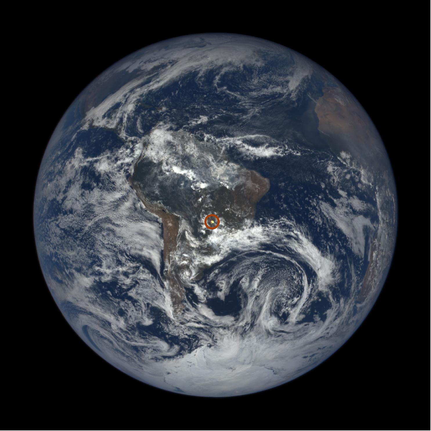
• March 2, 2017: On February 26, 2017, the skies above Argentina dimmed and the landscape darkened as the Moon moved in front of the Sun, partially blocking its rays. The same thing happened that day in Chile and Angola, as a “ring of fire” (annular eclipse) appeared over the South Atlantic. 47)
- An annular eclipse occurs when the Moon passes in front of the Sun but is too far from Earth to completely obscure it. This geometry leaves the Sun’s edges exposed in a red-orange ring. The NASA satellites DSCOVR and Aqua caught several earthly views of the event.
- The animation of Figure 30 shows a static view of Earth and the progression of the eclipse shadow. It is composed from 13 separate images acquired by the MODIS (Moderate Resolution Imaging Spectroradiometer ) instruments on NASA’s Aqua and Terra satellites, as well as the VIIRS (Visible Infrared Imaging Radiometer Suite) sensor on the Suomi-NPP satellite. Each satellite follows the same orbital path but passes over points on Earth at slightly different times in a two-hour span.
- But the February event will soon be eclipsed, so to speak, by another one. On August 21, 2017, a total solar eclipse will cross the entire continental United States for the first time in nearly four decades. The total eclipse will take about 90 minutes to cross from Oregon to South Carolina. During that time, 11 NASA-funded science teams will gather observations of the Sun’s tenuous atmosphere (corona)—which is too faint to see next to the bright solar disk — and of how the eclipse affects Earth and its atmosphere.
- “When the Moon blocks out the Sun during a total eclipse, those regions of Earth that are in the direct path of totality become dark as night for almost three minutes,” said Steve Clarke, director of NASA’s Heliophysics Division, in an earlier interview. “This will be one of the best-observed eclipses to date, and we plan to take advantage of this unique opportunity to learn as much as we can about the Sun and its effects on Earth.”
• February 2, 2017: NASA has upgraded its website that provides daily views of the Earth from the Lagrangian Point L1 (1.5 million km away). NASA’s EPIC (Earth Polychromatic Imaging Camera) camera imagery website was recently updated allowing the public to choose natural or enhanced color images of the Earth and even zoom into an area on the globe. 48)
- "The 'enhanced' color images make land features more visible," said Sasha Marshak, DSCOVR deputy project scientist at NASA/GSFC (Goddard Space Flight Center), Greenbelt, Maryland. "This is achieved by enhancing low intensity pixel values. The effect of atmospheric haze caused by air molecular scattering and attenuation of solar light by ozone has been also removed."
- EPIC is a 4 Mpixel CCD camera and telescope aboard NOAA's DSCOVR satellite that takes 10 narrow-band spectral images of the entire sunlit face of Earth from 317 - 780 nm. EPIC takes a new picture approximately every hour from mid-April to mid-October or every two hours for the rest of the year. EPIC images reveal how the planet would look to human eyes, capturing the ever-changing motion of clouds and weather systems and the fixed features of Earth such as deserts, forests, and the distinct blues of different seas.
- The EPIC website upgrade includes a new magnification feature where users get a zoomed-in look at an area under their cursor. Magnified areas appear in a circular box on screen.

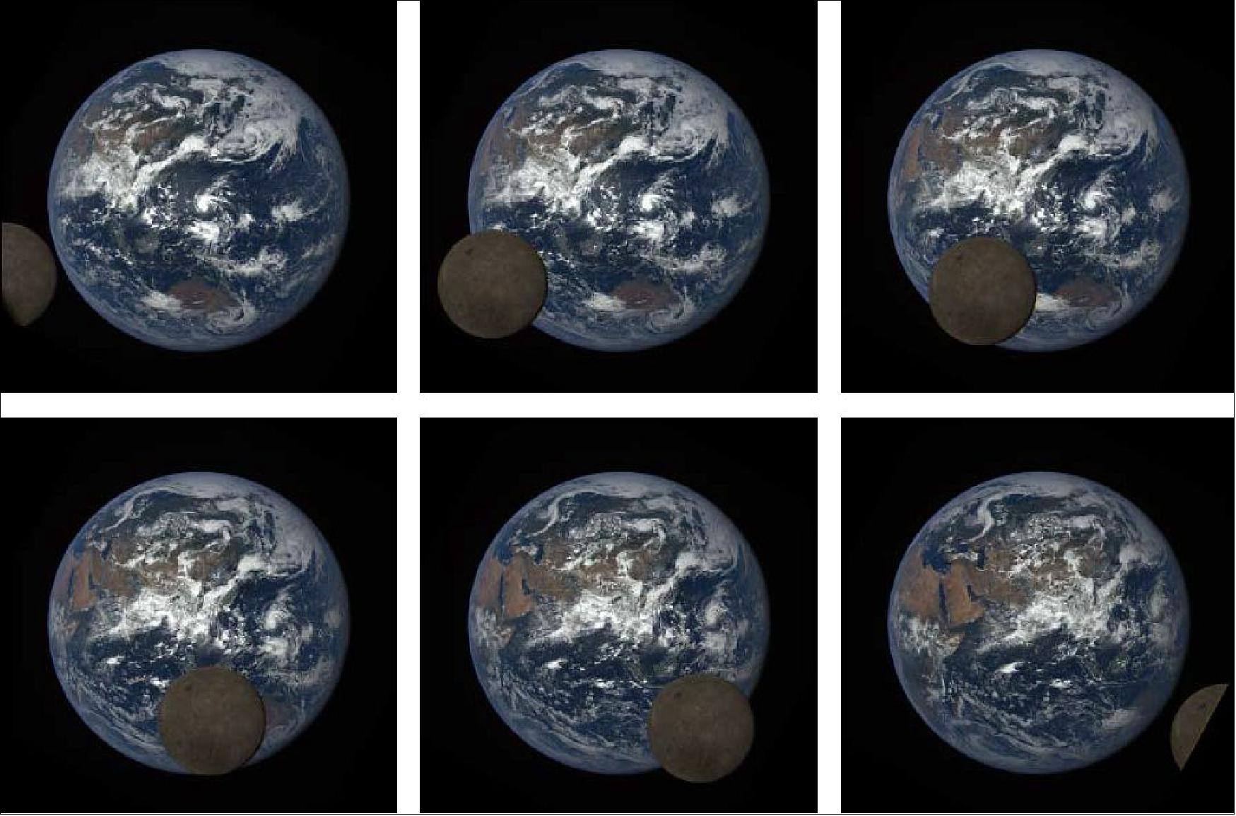
• On July 20, 2016, the DSCOVR project, together with the DSCOVR Earth Sensors science team and the Atmospheric Science Data Center (ASDC) at NASA/LaRC (Langley Research Center), released Level 1 data for EPIC (Earth Polychromatic Imaging Camera). Release of the National Institute of Standards and Technology (NIST) Advanced Radiometer (NISTAR) Level 1 data was expected shortly thereafter. The released datasets have initial versions of instrument calibration and geolocation applied. The EPIC data are not yet stray-light corrected but this is expected later in the year. The released data are available from June 2015 through the current day via the ASDC. EPIC has obtained two spectacular sequences of lunar transit images since being in operation. The most recent transit images of the Earth and the moon are shown in Figure 32. 49) The full lunar transit gallery can be seen at: 50) 51)
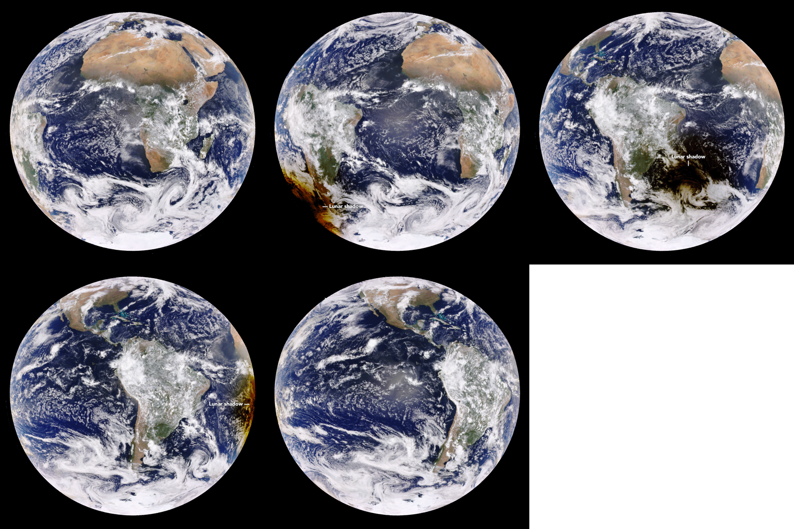
• March 10, 2016: DSCOVR was built to provide a distinct perspective on our planet. Yesterday, it added another first to its collection of unique snapshots. While residents of islands and nations in the Western Pacific looked up in the early morning hours to observe a total eclipse of the Sun, DSCOVR looked down from space and captured the shadow of the Moon marching across Earth’s sunlit face. 52)
- “What is unique for us is that being near the Sun-Earth line, we follow the complete passage of the lunar shadow from one edge of the Earth to the other,” said Adam Szabo, NASA’s project scientist for DSCOVR. “A geosynchronous satellite would have to be lucky to have the middle of an eclipse at noon local time for it. I am not aware of anybody ever capturing the full eclipse in one set of images or video.”
- In this, the only total solar eclipse of 2016, the shadow of the new Moon starts crossing the Indian Ocean and marches past Indonesia and Australia into the open waters and islands of Oceania (Melanesia, Micronesia, and Polynesia) and the Pacific Ocean. Note how the shadow moves in the same direction as Earth rotates. The bright spot in the center of each disk is sunglint—the reflection of sunlight directly back at the EPIC camera.
- From its position of about 1.5 million km from Earth and toward the Sun, DSCOVR maintains a constant view of the sunlit face of the planet. EPIC acquires images using ten different spectral filters—from ultraviolet to near infrared—to produce a variety of science products. Natural-color images are generated by combining three separate monochrome exposures (red, green, and blue channels) taken in quick succession.
- According to Szabo, the satellite normally collects images at all ten wavelengths about once every 108 minutes (with just one image at full resolution). For this eclipse, the EPIC team collected full-resolution images every 20 minutes on just the red, green, and blue channels. This allowed the satellite to collect 13 images spanning the entire four hours and twenty minutes of the eclipse.
- In addition to the EPIC camera, DSCOVR carries NISTAR (National Institute of Standards and Technology Advanced Radiometer), an instrument that measures how much solar energy is being radiated back into space from Earth. In coming weeks, scientists will be analyzing NISTAR data to quantify how the eclipse changed the incoming and outgoing radiation for those few hours.
- Situated in a stable orbit between the Sun and Earth, DSCOVR’s primary mission is to monitor the solar wind for space weather forecasters at NOAA (National Oceanic and Atmospheric Administration). Its secondary mission is to provide daily color views of our planet as it rotates through the day. The satellite was built and launched through a partnership between NASA, NOAA, and the U.S. Air Force.

• On February 11, 2016, the DSCOVR spacecraft was launched one year ago. The deep-space mission DSCOVR will soon replace NASA’s 17-year old ACE research satellite as America’s primary warning system for geomagnetic storms and solar wind data. NASA will be responsible for coordinating ACE's continued role in space weather research. 53)
• On October 28, 2015, NOAA officially took command of its DSCOVR satellite. NASA, in charge of both the launch and activation of the satellite, has officially handed over satellite operations to NOAA’s DSCOVR team. Next, the team will optimize the final space weather instrument settings and the satellite will soon begin normal operation. 54)
- DSCOVR will give NOAA’s SWPC (Space Weather Prediction Center) forecasters higher-quality measurements of solar wind conditions, improving their ability to monitor and warn of severe and potentially dangerous space weather events. DSCOVR will be able to provide warnings 15 to 60 minutes before solar storms reach Earth.
• On Oct. 19, 2015, NASA launched a new website so the world can see images of the full, sunlit side of the Earth every day. Once a day NASA will post at least a dozen new color images of Earth acquired from 12 to 36 hours earlier by NASA’s EPIC (Earth Polychromatic Imaging Camera). Each daily sequence of images will show the Earth as it rotates, thus revealing the whole globe over the course of a day. The new website also features an archive of EPIC images searchable by date and continent. 55)
- The primary objective of NOAA’s DSCOVR mission is to maintain the nation’s real-time solar wind monitoring capabilities, which are critical to the accuracy and lead time of space weather alerts and forecasts from NOAA. NASA has two Earth-observing instruments on the spacecraft. EPIC's images of Earth allow scientists to study daily variations over the entire globe in such features as vegetation, ozone, aerosols, and cloud height and reflectivity.

• August 6, 2015: A NASA camera aboard the DSCOVR (Deep Space Climate Observatory) spacecraft has captured a unique view of the Moon as it passed between the spacecraft and Earth. The 4 Mpixel CCD camera (EPIC) and telescope on the DSCOVR satellite maintains a constant view of the fully illuminated Earth as it rotates, providing daily scientific observations of ozone, vegetation, cloud height, and airborne aerosols. About twice a year the camera will capture images of the Moon and Earth together as the orbit of DSCOVR crosses the orbital plane of the Moon. 56) 57)
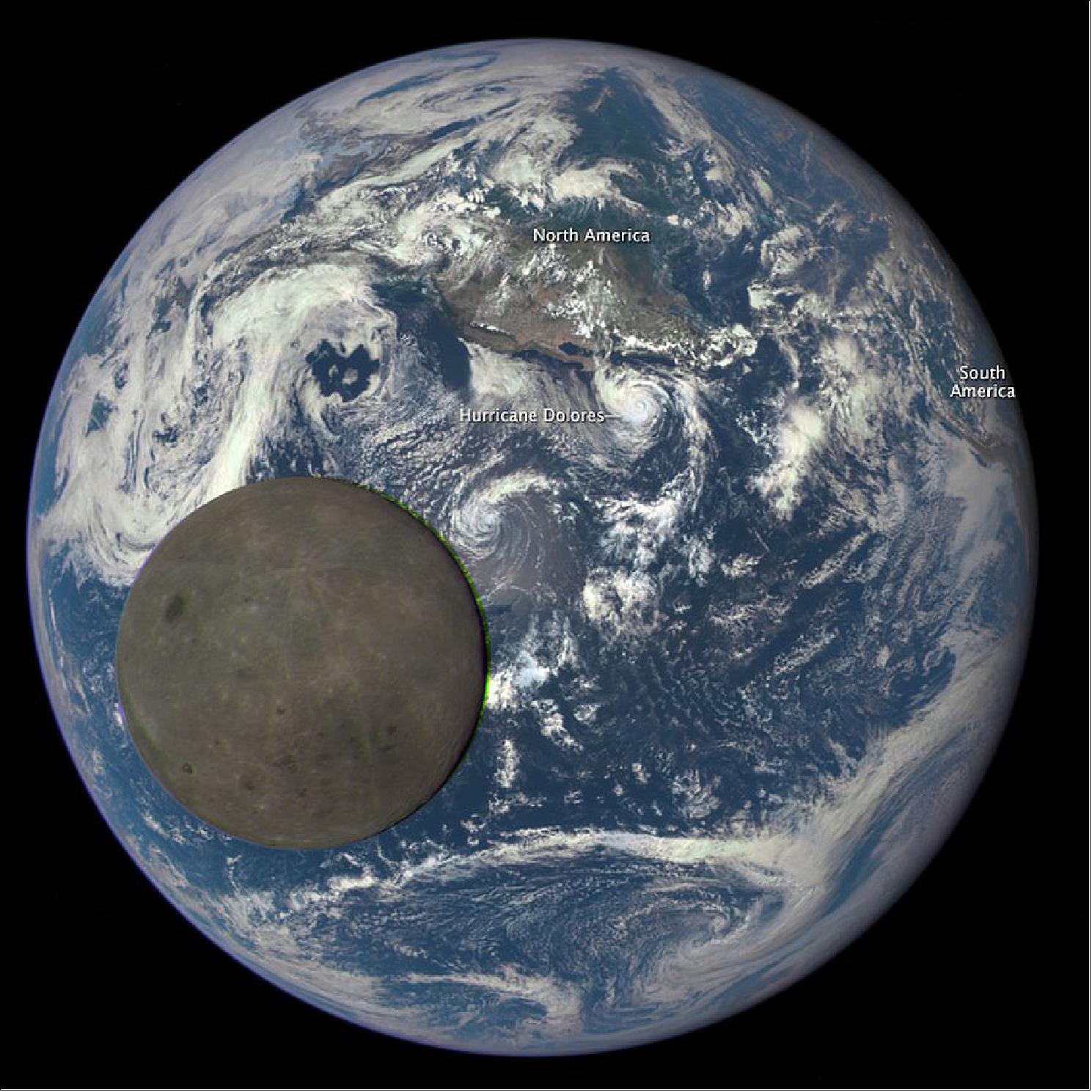
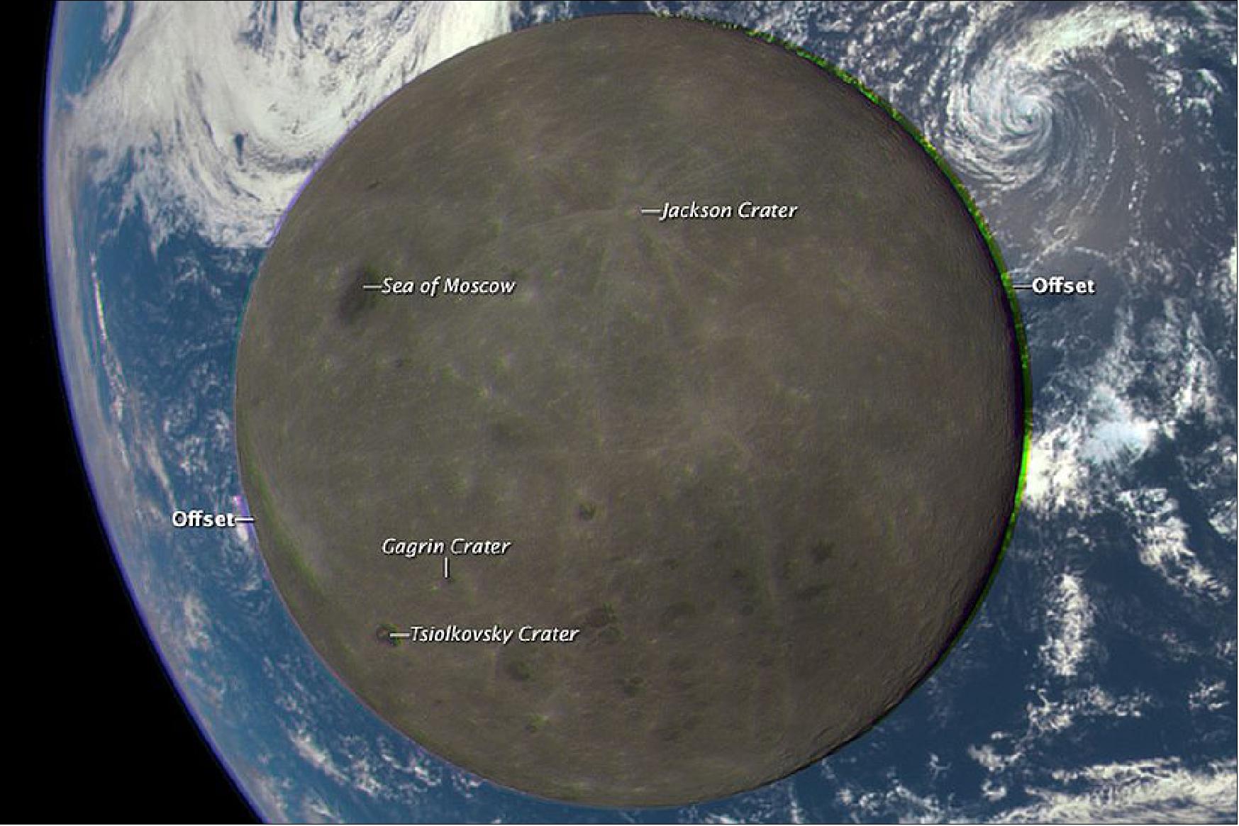
• July 20, 2015: The EPIC (Earth Polychromatic Imaging Camera) instrument aboard the DSCOVR spacecraft has returned its first view of the entire sunlit side of Earth from L1, 1.5 million km away in the direction of the sun. The color images of Earth from NASA's EPIC are generated by combining three separate images to create a photographic-quality image. The camera takes a series of 10 images using different narrowband filters — from ultraviolet to near infrared — to produce a variety of science products. The red, green and blue channel images are used in these Earth images. 58) 59)
- "This first DSCOVR image of our planet demonstrates the unique and important benefits of Earth observation from space,” said NASA Administrator Charlie Bolden. “As a former astronaut who’s been privileged to view the Earth from orbit, I want everyone to be able to see and appreciate our planet as an integrated, interacting system. DSCOVR’s observations of Earth, as well as its measurements and early warnings of space weather events caused by the sun, will help every person to monitor the ever-changing Earth, and to understand how our planet fits into its neighborhood in the solar system.”
- These initial Earth images show the effects of sunlight scattered by air molecules, giving the images a characteristic bluish tint. The EPIC team now is working on a rendering of these images that emphasizes land features and removes this atmospheric effect. Once the instrument begins regular data acquisition, new images will be available every day, 12 to 36 hours after they are acquired by EPIC. These images will be posted to a dedicated web page by September.
- "The high quality of the EPIC images exceeded all of our expectations in resolution," said Adam Szabo, DSCOVR project scientist at NASA/GSFC (Goddard Space Flight Center) in Greenbelt, Maryland. "The images clearly show desert sand structures, river systems and complex cloud patterns. There will be a huge wealth of new data for scientists to explore."
- The primary objective of DSCOVR is to maintain the nation’s realtime solar wind monitoring capabilities, which are critical to the accuracy and lead time of space weather alerts and forecasts from NOAA.
- In addition to space weather instruments, DSCOVR carries a second NASA sensor — the NISTAR (National Institute of Science and Technology Advanced Radiometer ). Data from the NASA science instruments will be processed at the agency’s DSCOVR Science Operations Center in Greenbelt, Maryland. This data will be archived and distributed by the Atmospheric Science Data Center at NASA/LaRC (Langley Research Center) in Hampton, Virginia.

• June 8, 2015: More than 100 days after it launched, NOAA’s DSCOVR (Deep Space Climate Observatory) satellite has reached its orbit position, about one 1.5 million km from Earth. Once final instrument checks are completed, DSCOVR, which will provide improved measurements of solar wind conditions to enhance NOAA’s ability to warn of potentially harmful solar activity, will be the nation’s first operational space weather satellite in deep space. Its orbit between Earth and the sun is at a location called the Lagrange point 1, or L1, which gives DSCOVR a unique vantage point to see the Earth and sun. The satellite is expected to begin operations this summer. 60)
- Data from DSCOVR, coupled with a new forecast model set to come online in 2016, will enable NOAA’s space weather forecasters to predict geomagnetic storm magnitude on a regional basis. Geomagnetic storms occur when plasma and magnetic fields streaming from the sun impact Earth’s magnetic field. Large magnetic eruptions from the sun have the potential to bring major disruptions to power grids, aviation, telecommunications, and GPS systems.
- DSCOVR will eventually replace NASA’s ACE (Advanced Composition Explorer) research satellite as America’s primary warning system for solar magnetic storms headed towards Earth. ACE will continue to provide valuable research data to the science community.
- In addition to space weather-monitoring instruments, DSCOVR is carrying two NASA Earth-observing instruments that will gather a range of measurements from ozone and aerosol amounts, to changes in Earth's radiation budget—the balance between incoming radiation (largely from the sun) and that which is reflected from Earth. This balance affects our climate.
• February 24, 2015: In just 12 days after it launched, NOAA's DSCOVR satellite has reached the halfway mark to the L1 position. In 12 days, DSCOVR has traveled approximately 0.8 million km. However, just as a ball loses speed at the top of its arc, DSCOVR is losing speed. As DSCOVR moves further away from the earth, the sun's gravity comes into play and bends the trajectory. This results in curved trajectory versus a "straight-line" approach. It will take DSCOVR another 100 days to travel the remaining distance to L1 (at 1.5 million km from Earth). This will put the expected arrival time of DSCOVR at L1 around the beginning of June. 61)
Sensor Complement
The primary objective of the sensor complement is to measure the solar wind (np, vp, tp) and the interplanetary magnetic field at 240 RE forward of the Earth.
The DSCOVR solar wind/IMF data will be downlinked to the Real Time Solar Wind Network (RTSWnet). 62)
Secondary mission objectives: Earth observations. The Earth viewing instruments on DSCOVR have a continuous view of the entire sunlit face of the Earth.
Level 1 science requirements
Threshold science requirements of the DSCOVR mission that enables real-time space weather forecasting are:
• Measure the interplanetary vector magnetic fields in the range of 0 – 100 nT with an absolute accuracy of ±1 nT
• Measure the bulk velocity of the proton component of the thermal solar wind in the range of 200 – 1250 km/s with a 20% accuracy.
• Measure the density of the proton component of the thermal solar wind in the range of 1 –100 particles/cm3 with a 20% accuracy.
• Measure the temperature of the proton component of the thermal solar wind in the range of 40,000 – 2,000,000 Kelvin with 50% accuracy.
• Measure the above parameters with a cadence of 1 sample per minute or better.
• Deliver the above measurements with a system latency of no more than 5 minutes.
- The latency is measured as the time of instrument measurement to the time the data are processed to Level 2 and stored on a SWPC (Space Weather Prediction Center) server.
EPIC (Earth Polychromatic Imaging Camera)
The EPIC instrument was managed by SIO (Scripps Institution of Oceanography) at USCD (University of California at San Diego) and built by LMATC (Lockheed Martin’s Advanced Technology Center) in Palo Alto, CA. The objective is to measure ozone amounts, aerosol amounts, cloud height and phase, hotspot land properties (a view of the land from angles where shadows are a minimum), and UV radiation estimates at the Earth's surface. EPIC is able to view the entire sunlit Earth from sunrise to sunset at an almost constant scattering angle between 165‐178º. The EPIC channels were selected to match closely with TOMS in the UV region and with MODIS in the visible range; hence, the data products will be very similar and can be directly compared. These comparisons will validate both the calibration and data reduction algorithms.
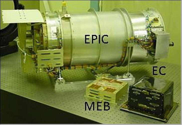
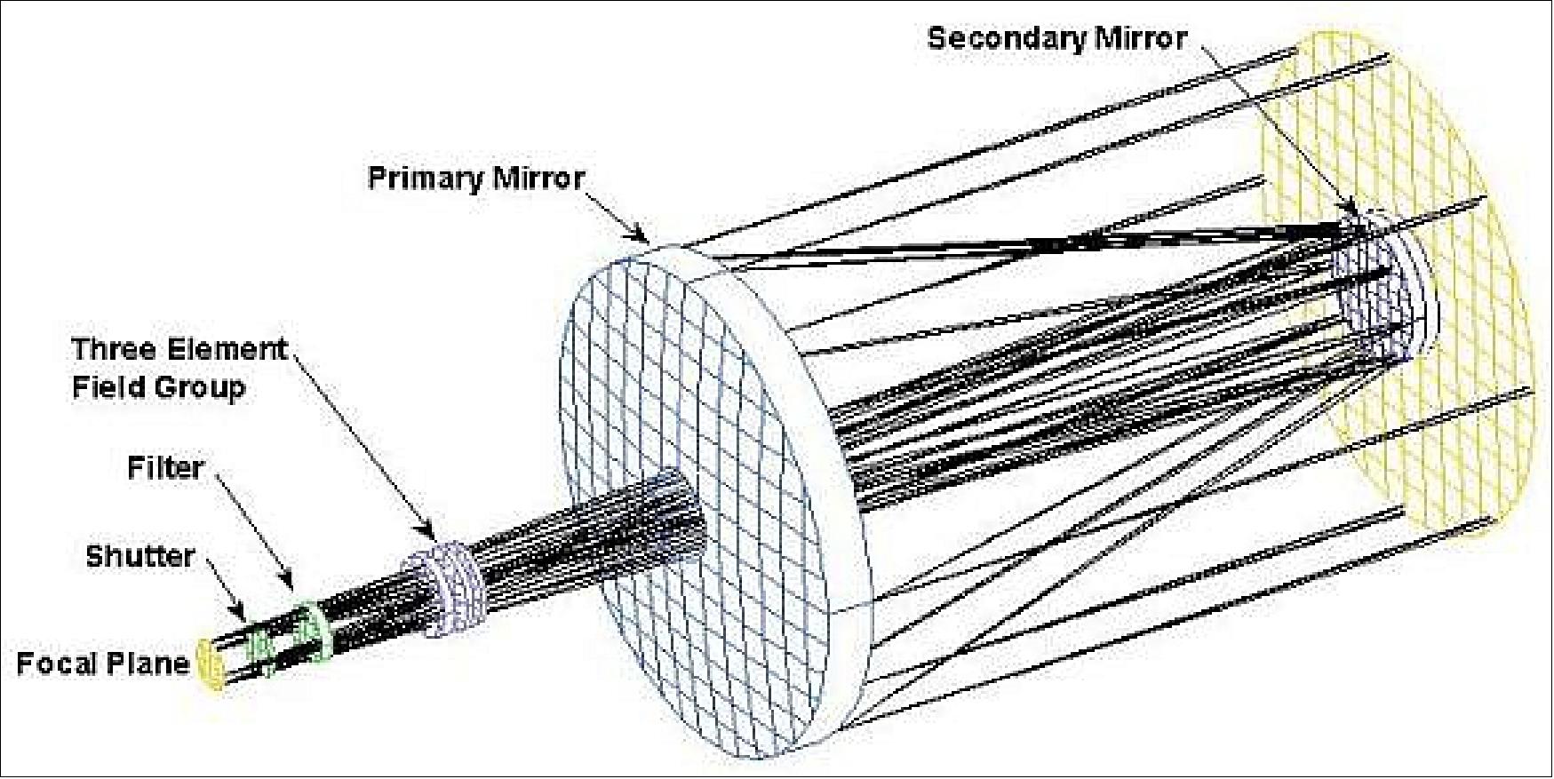
The instrument system consists of the EPIC instrument, MEB (Mechanisms Electronics Box) and EC (EPIC Computer) which controls the instrument and interfaces to the spacecraft avionics. EPIC’s telescope, built by SSG Inc., is a reflecting Ritchey-Chrétien design with an aperture diameter of 30.5 cm, f 9.38, a FOV (Field of View) of 0.61º, and an angular sampling resolution of 1.07 arcsec. Once at L1, Earth (plus 100 km) varies from 0.45º to 0.53º full width. 63) 64)
Telescope: | Cassegrain type with adjustable secondary for on‐orbit focus |
Shutter | Individual exposure times of 2 ms, 10 ms and 40 ms to >1 min |
Focal plane assembly: |
|
Minimum image cadence | < 20 s |
Image output format | Raw (bit map) and 12 bit JPEG/JFIF |
Instrument power; total mass | 32 W (electronics), 30 W (operational heaters); 63.2 kg |
Center wavelength (nm) | FWHM (nm) | Primary purpose |
317 | 1 | Ozone |
325 | 1 | Ozone |
340 | 3 | Ozone, aerosols. reflectivity |
388 | 3 | Aerosols. reflectivity, vegetation, RGB |
443 | 3 | Aerosols. reflectivity, vegetation, RGB |
552 | 3 | Aerosols. reflectivity, vegetation, LAI, O2B-band reference, RGB |
680 | 2 | Aerosols. reflectivity |
688 | 0.8 | O2B-band cloud height, aerosol height |
764 | 1 | O2B-band cloud height |
779 | 2 | Aerosols, reflectivity, vegetation, LAI, O2B-band reference |
• Ozone: total column
• Aerosol properties: aerosol index, aerosol optical thickness, aerosol height
• Cloud & surface properties: cloud fraction, cloud height, surface albedo
• Vegetation properties: vegetation index and LAI (Leaf Area Index)
• RGB: colored image of the Earth’s sunlit face.
EPIC challenges (Ref. 11):
• Geolocation: The spacecraft jitter is expected to be on the order of 1 pixel. This increases EPIC’s effective field of view. The ‘edge’ of the Earth and the outline of the continents will have to be used to exactly geo-locate the images. This is especially important for the algorithms based on ratios of channels.
• Stray light: EPIC’s (spatial) stray light is significant and must be corrected. A very complex stray light correction algorithm is being developed. It is based on laboratory measured point spread functions and calculations of an optical model.
• Instrument stability: The radiometric stability of EPIC will be tracked using the measured reflectivity over ice-covered surfaces and by periodic images of the moon’s sunlit face at a nearly constant phase angle when it is furthest from the Earth as seen from L1.
NISTAR (National Institute of Standards and Technology Advanced Radiometer)
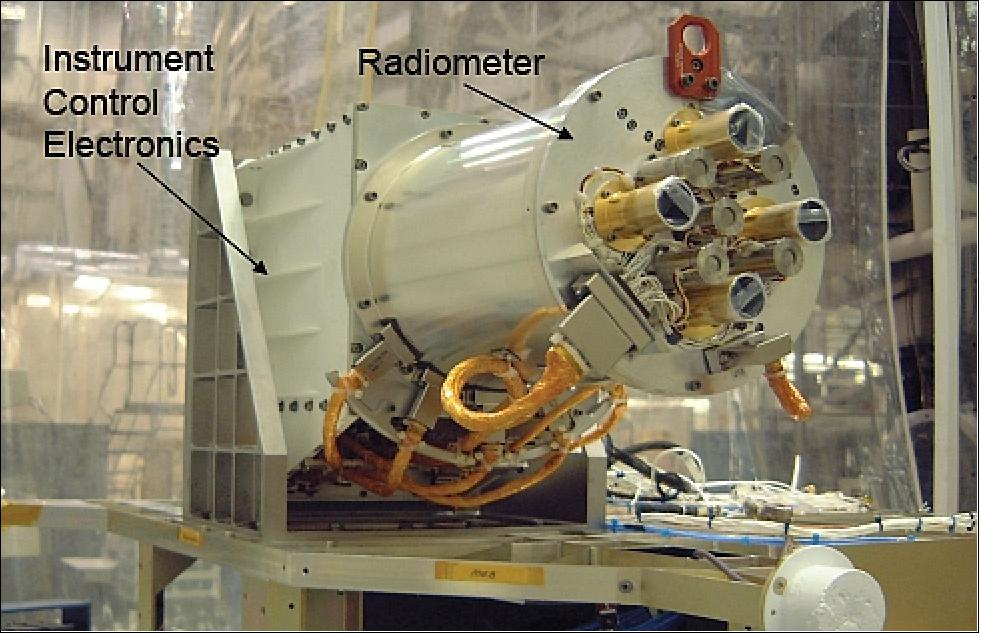
The NISTAR cavity radiometer was designed and developed by NIST (National Institute of Standards and Technologies) of Gaithersburg, MD and Ball Aerospace of Boulder, CO. The objective was to measure the radiance output from the sunlit Earth over a broad portion of the spectrum (UV and VIS as reflected radiation, IR as emitted radiation) in order to detect changes in the Earth's energy balance (climate studies).
The NISTAR instrument package includes four detectors: three active-cavity electrical substitution radiometers and one silicon photodiode channel to measure the “total Earth reflected and emitted radiant power” received in the direction of the spacecraft. 65) 66)
NISTAR measures the absolute irradiance integrated over the entire sunlit face of the Earth in 4 broadband channels minute-by-minute. The measurements performed by NISTAR will be of high accuracy, on the order of 0.1%. NISTAR provides 3 broadband channels (A, B, C) plus a photodiode channel.
A) A UV to far infrared (0.2 µm to 100 µm) channel to measure the total radiant power UV, VIS and IR wavelengths emerging from the Earth.
B) A solar (0.2 µm to 4 µm) channel to measure reflected solar radiance in UV, VIS and NIR wavelengths.
C) A near infrared (0.7 µm to 1.1 µm) channel to measure the reflected IR solar radiation
D) Photodiode channel (0.2 µm to 1.1 µm) for monitoring of radiometer filter elements (channel for calibration reference).
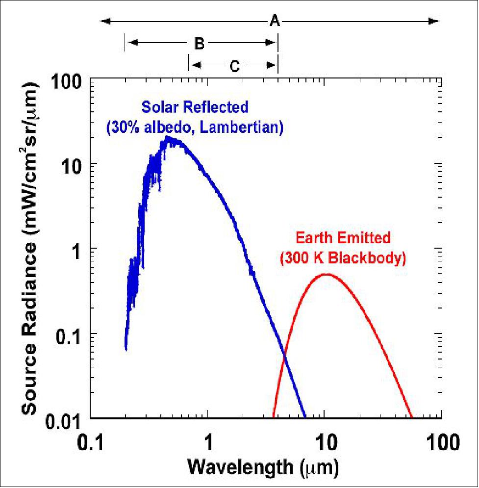
The goal of NISTAR is to measure the Earth’s energy balance (solar input and Earth reflection and radiation to space) with sufficient accuracy (0.1%) to improve our understanding of the effects of changes caused by human activities and natural phenomena.
In 2010, the NISTAR instrument was re-calibrated against a portable version of the NIST SIRCUS (Spectral Irradiance and Radiance Responsivity Calibrations using Uniform Sources) facility. The calibration was performed with the NISTAR space-flight instrument in a thermal vacuum chamber in a clean-room environment at NIST. This calibration included system-level measurements of the relative spectral response of the NISTAR bands using a wavelength-tunable laser, and absolute responsivity measurements of each of the four NISTAR detectors at 532 nm. The standard uncertainty of the absolute responsivity calibration obtained using this technique was 0.12 % (k=1). 67) 68)
NISTAR has a FOV of 1º, sufficient to see and image the full Earth disk whose FOV is approximately 0.5º as seen from L1. The photodiode channel has been included in order to obtain a faster time series (<1 s) than what can be obtained by the cavity radiometers. The channel is used to provide for the tracking stability of the filters, to verify co‐alignment of NISTAR and EPIC, and to continuously observe the solar reflected broadband radiation from Earth with high temporal resolution.
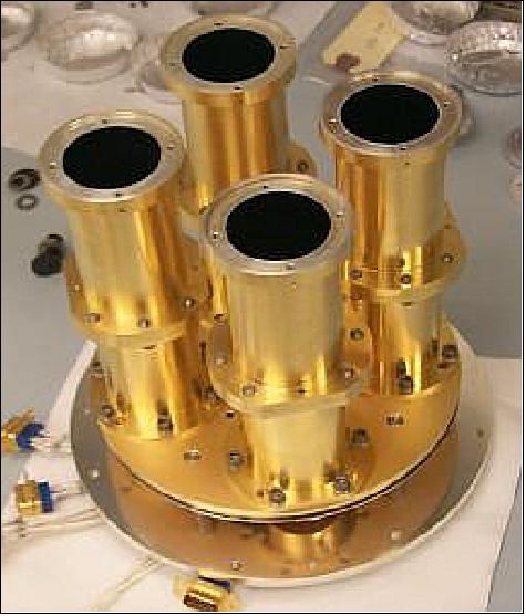
A PTC (Positive Temperature Coefficient) thermistor and a wire‐wound low‐temperature coefficient heater are bonded to the outside of the 30º conical receiver cavity. The absolute cavity radiometers are designed for optimum power measurements (in the tens of μW range). The optical signal incident on the receiver is only 1 μWcm‐2, however, the emission from the receiver cavity to space is estimated to be 30 μWcm‐2 when the shutter is open. There are four digital control loops, three receiver cavity control loops and one for the heat sink. The PTC temperature sensor resistance measurements are performed with AC‐bridge circuits operating between 35 and 155 Hz. The NISTAR absolute cavity radiometers are designed for a noise floor of less than 10 nW (defined as the level at which the SNR is equal to one for a single one second measurement). The NISTAR electronics have a measurement resolution of 10 mΩ and internal equivalent noise of less than that. The NISTAR total instrument mass is 25.5 kg.
DSCOVR’s location at the L1 observing position, rather than in Earth orbit, will permit long integration times, since no scanning will be required. A radiometric accuracy of 0.1-0.2% is expected, a 10-fold improvement in accuracy over current Earth-orbiting satellite data. These will be the only measurements of the entire Earth’s reflected and emitted radiation at the retro reflection angle. As such, NISTAR will provide important missing data not obtainable by any Earth-orbiting satellite.
PlasMag Instrument Suite
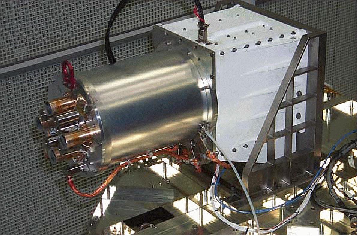
The PlasMag (Plasma Magnetometer) instrument suite of NASA/GSFC and MIT (Massachusetts Institute of Technology) is a comprehensive science and space-weather package that includes a fluxgate vector magnetometer, not present on SOHO, a Faraday Cup solar wind positive ion detector and a top-hat electron electrostatic analyzer. This instrument cluster provides high time resolution measurements in real time and represents the next generation of upstream solar wind monitors intended to provide continuity of measurements started by IMP-8, WIND, SOHO and ACE. 69)
Faraday Cup: The PlasMag Faraday Cup will provide very high time resolution (0.5 second) solar wind bulk properties in three dimensions, which coupled with magnetic field data (20 vectors/second), will allow the investigation of solar wind waves and turbulence at unprecedented time resolution. This, in turn, will allow new insights into the basic plasma properties: the process of turbulent cascade and the rate of reconnection. Both topics are critical in understanding the nature of coronal heating.
The electron electrostatic analyzer will allow the continual observation of the 3D electron distribution function for various solar wind conditions. Special attention will be given to the supra-thermal component or "strahl" that follows the interplanetary field lines very closely and provides the closest link to the formation of the solar wind in the upper corona. It provides a way of identifying large magnetic loops that are still connected at both ends to the solar corona.
It is important that DSCOVR be at L1 before the ACE mission ends, to allow for cross calibration of the solar instruments, to augment solar wind early warning, and to eventually replace ACE. The DSCOVR PlasMag fluxgate magnetometer will provide crucial continuity of observation of this important interplanetary solar wind parameter. The magnetic field measurements will allow, among other things, the connection of the photospheric magnetic sector structure to 1 AU heliospheric current sheet observations.
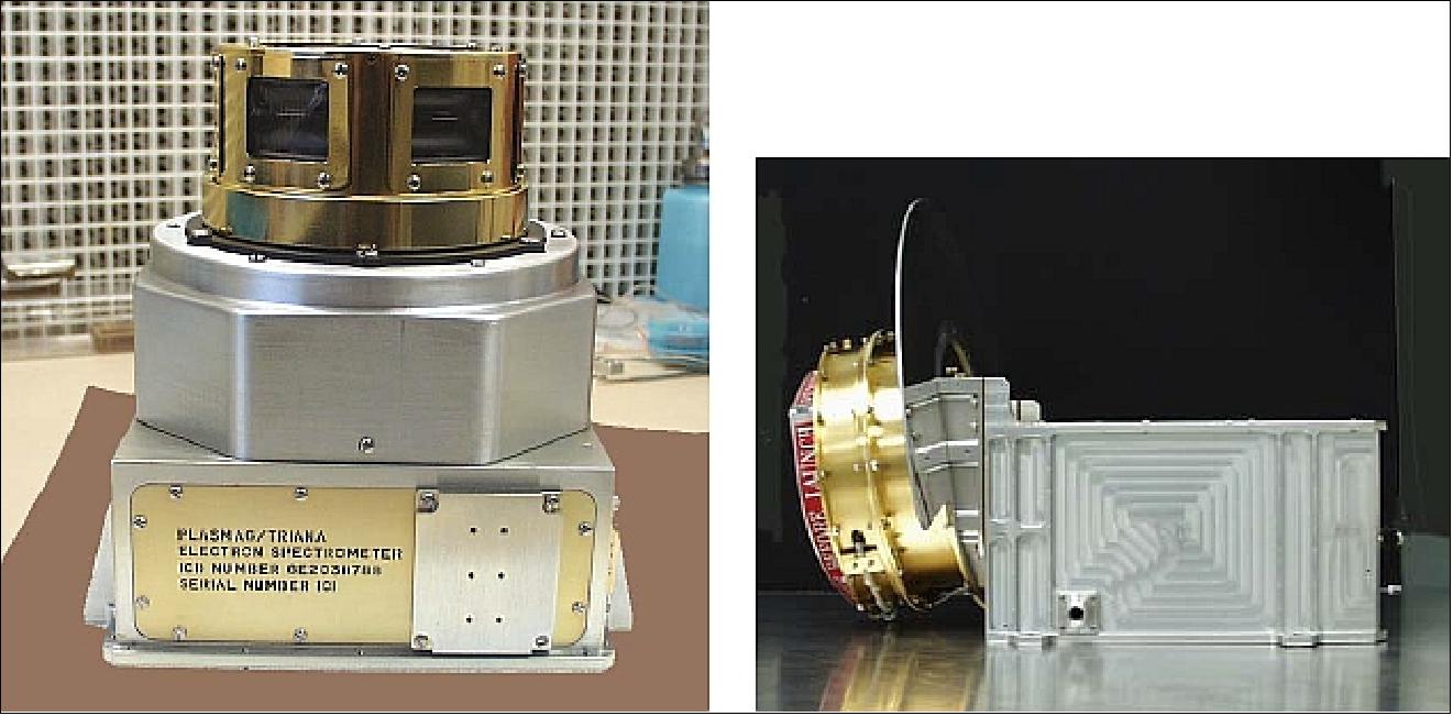
Electron spectrometer: The objective of the top-hat electron spectrometer is to provide high time resolution (<1 s) solar wind electron, full 3D distribution function observations. While electron measurements have an inherently higher uncertainty, the electron spectrometer may extend space weather monitoring to unusually high speed events. The electron spectrometer sits at the tip of mag boom to gain a nearly 4π FOV (Ref. 6).
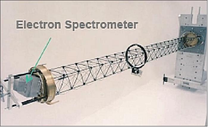
PHA (Pulse Height Analyzer)
The objective of PHA is to monitor the effect of high energy particles on spacecraft electronics. PHA is an instrument designed and built by GSFC. It was previously flown of STS-95 (Oct. 1998).
• PHA is a small, low power, HiLRS (High Linear Energy Transfer Radiation Spectrometer) to evaluate SEUs (Single Event Effects) on microelectronics in the space environment
• PHA provides in-flight measurement of a spectrum of ionizing particle energy, charge, and mass.
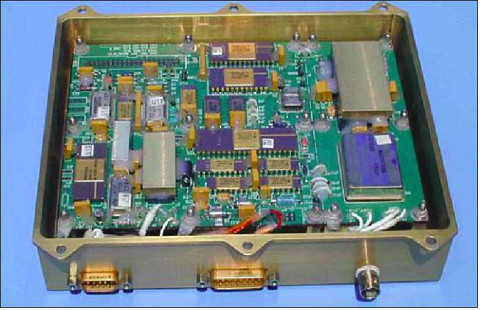
Ground Segment
The NOAA-OSD (Office of Systems Development) Ground Systems Division (GSD) provides technical and engineering consultation for satellite ground systems and supporting facilities. The support GSD provides encompasses the entire end-to-end satellite data flow from spacecraft and instrument commanding, to capture of raw satellite data telemetry streams, and finally to processing and distribution of derived imagery and data products for consumption by worldwide users. 70) 71)
GSD functions:
• Provide expertise in satellite ground systems design with emphasis in telemetry and command, instrument data processing, image display and analysis, product generation, data archiving, communications, and associated ground equipment, infrastructure and facilities
• Plan ground system activities leading to new satellite systems, including the introduction of significant new services and products from Research-to-Operations and International satellite missions
• Evaluate new technologies for satisfying current and future ground systems requirements, from raw data capture through distribution of products to users
• Lead ground systems development efforts including specifying, procuring, installing, and testing NESDIS hardware and software systems resulting from requirements generated during system planning activities.
• Work directly with NOAA-OSPO (Office of Satellite and Product Operations), NOAA-OSO (Office of Systems Operations), NASA and other agencies to ensure compatibility of future satellites with existing and future ground systems
• Provide support to the OSPO and the Center for SaTellite Applications and Research (STAR) for Information Technology refresh and enhancement projects.
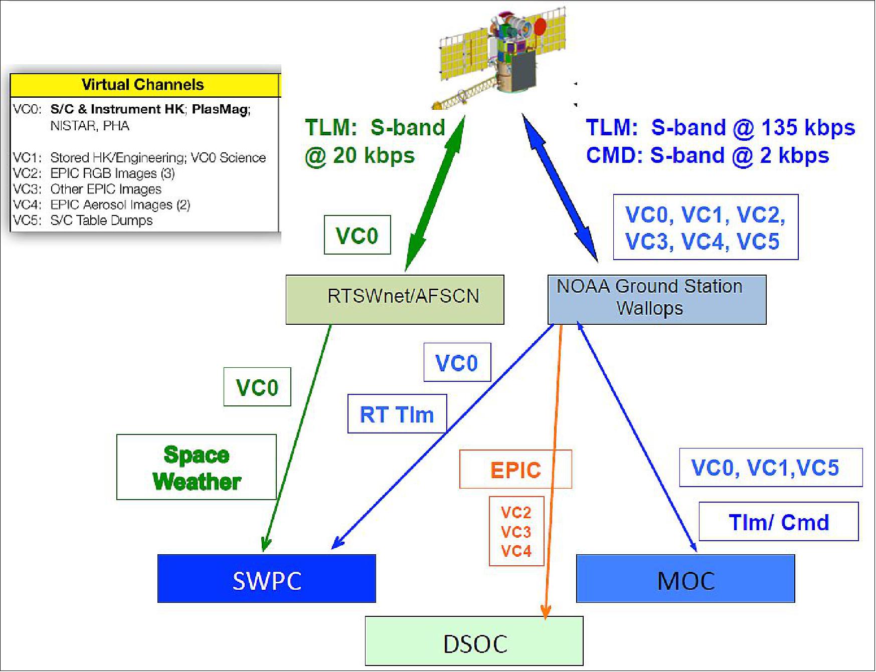
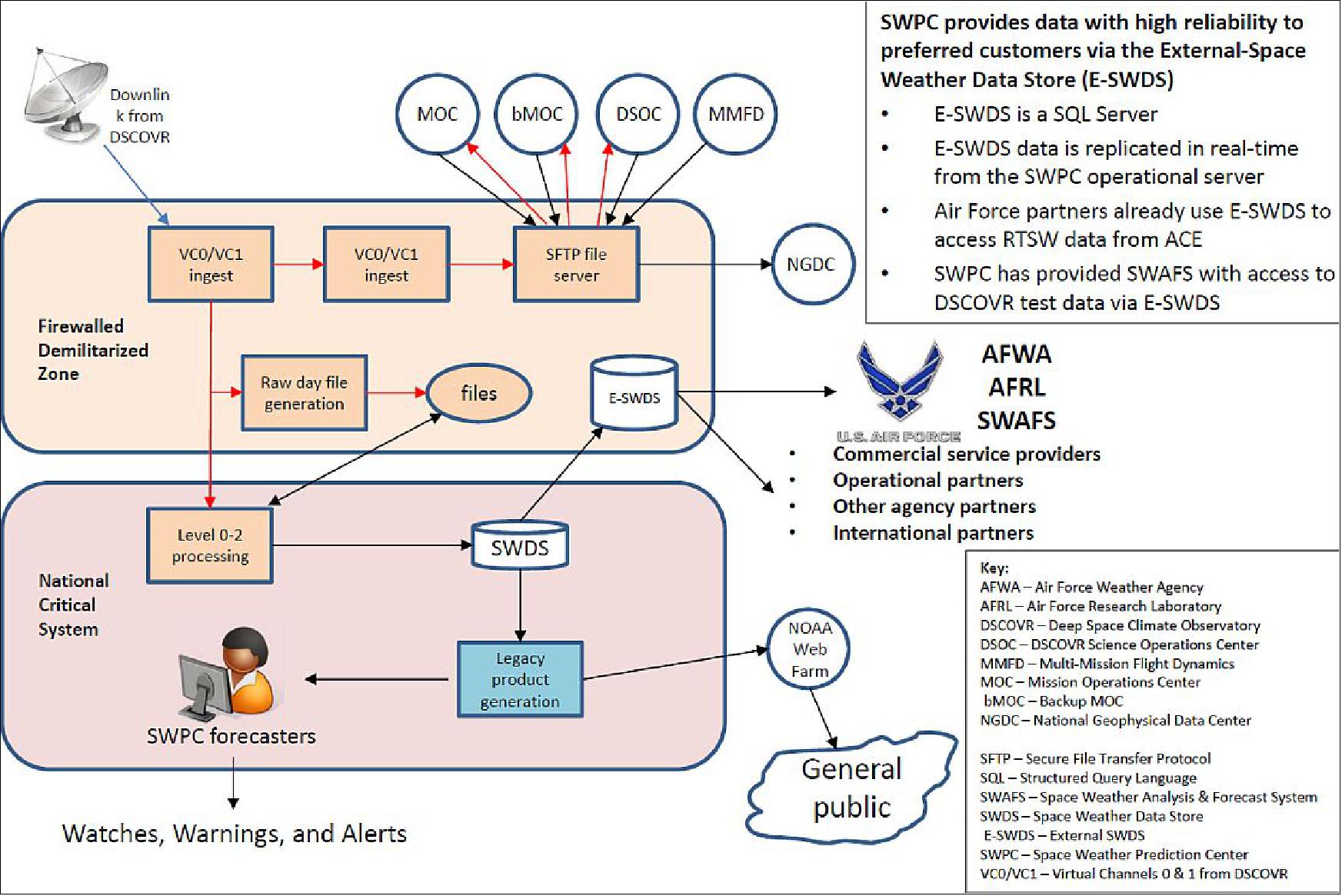
References
1) Joe Burt, Bob Smith, “The DSCOVR Mission,” Proceedings of the 2012 IEEE Aerospace Conference, Big Sky, Montana, USA, March 3-10, 2012
2) Francisco P. J. Valero, Jay Herman, Patrick Minnis, William D. Collins, Robert Sadourny, Warren Wiscombe, Ddan Lubin, Keith Ogilie, “Triana ‐ a Deep Space Earth and Solar Observatory,” Report prepared for the National Academy of Sciences by the Triana Science Team (SIO, NASA/GSFC, NIST, LaRC, ARC, NCAR, LMD, LM, LANL, VT)
3) J. G. Watzin, “The Triana Mission ‐ A Pathfinder Mission to Explore the Utility of using Deep Space in Conducting Earth Observation,” Proceedings of the 51st IAF Congress, Rio de Janeiro, Brazil, Oct. 2‐6, 2000
4) S. A. W. Gerstl, F. P. J. Valero, “The Triana Satellite Mission from L1 for Global Vegetation Monitoring,” Proceedings of IEEE/IGARSS'99, Vol. I, Hamburg, June 28‐July 2, 1999
5) Francisco P. J. Valero, “Triana: An Island View at L1,” Space Daily, 1999, URL: http://www.spacedaily.com/news/oped-99e.html
6) Quang-Viet Nguyen, “Deep Space Climate Observatory (DSCOVR) Mission Briefing,” Heliophysics Subcommittee Meeting, NASA HQ, Washington, DC, Feb. 27-28, 2012, URL: http://science.nasa.gov
/media/medialibrary/2012/03/01/Nguyen-DSCOVR-Mission-Briefing-HPS-v01b.pdf
7) “Deep Space Climate Observatory,” Wikipedia, URL: http://en.wikipedia.org/wiki/Deep_Space_Climate_Observatory
8) Jeff Foust, “People re-DSCOVR an existing program,” April 12, 2013, URL: http://www.spacepolitics.com/2013/04/12/people-re-dscovr-an-existing-program/
9) A. Szabo, K. W. Ogilvie, A. F. Viñas, E. J. Summerlin, “Solar Wind Kinetic Physics - High Time Resolution Solar Wind Measurements from the DSCOVR Mission,” DSCOVR White Paper, URL: http://www8.nationalacademies.org/SSBSurvey/DetailFileDisplay.aspx?id=750&parm_type=HDS
10) D. J. Knipp, D. A. Biesecker, “Changing of the Guard: Satellite Will Warn Earth of Solar Storms,” Eos, Vol. 96, doi:2015EO026579, published on 24 March 2015, URL: https://eos.org
/project-updates/changing-of-the-guard-satellite-will-warn-earth-of-solar-storms
11) Alexander Cede, Jay Herman, Alexander Marshak, “Overview of the Earth Science Instruments on the NASA DSCOVR mission,” ICAP (International Cooperative for Aerosol Prediction), ESA/ESRIN, Frascati, Italy, May 14 – 17, 2012, URL: http://bobcat.aero.und.edu/jzhang/ICAP/AERP
/MeetingPDFs/RemoteSensing/Cede-DSCOVR%20%28NXPowerLite%29.pdf
12) Francisco P. J. Valero, Brett C. Bush, Shelly K. Pope, V. Ramanathan, Jay Herman, Keith Ogilvie, Warren J. Wiscombe, Steven Lorentz, Joseph Rice, Patrick Minnis, Peter Pilewskie, William D. Collins, Claude Basdevant, Bernard Legras, Hector Teitelbaum, G. Louis Smith, Alan Strahler, Claudio Tomasi, Ankie J. M. Piters, John Burrows, Irina Melnikova, “NRC Earth Science Decadal Survey-Mission Concept Earth Sciences from the Astronomer’s Perspective, a Deep Space Climate Observatory (DSCOVR) ,”NRC (National Research Council), URL: http://geo-cape.larc.nasa.gov/docs/DSCOVR_RFI_030.pdf
13) http://www.osd.noaa.gov/DSCOVR/dscovr.html
14) http://www.nesdis.noaa.gov/DSCOVR/pdf/DSCOVR-facts-Jan15.pdf
15) Jeff Foust, “Storm preparations,” The Space Review, January 7, 2013, URL: http://www.thespacereview.com/article/2214/1
16) “DSCOVR: Mission Success for Moog Engines Over a Decade Later,” SpaceRef, Feb. 11, 2015, URL: http://spaceref.com/news/viewpr.html?pid=45046
17) “NOAA Satellite and Information Service -Deep Space Climate Observatory (DSCOVR),” URL: http://www.nesdis.noaa.gov/DSCOVR/pdf/DSCOVR%20-%20Program%20Overview%20Info%20Sheet.pdf
18) “New NOAA spacecraft readies for launch next month,” NOAA, Dec. 18, 2014, URL: http://www.noaanews.noaa.gov/stories2014/20141218_DSCOVR.html
19) “DSCOVR: Deep Space Climate Observatory,” Press Kit, NOAA/NESDIS, URL: http://www.nesdis.noaa.gov/DSCOVR/press.html
20) Adam Szabo, “Deep Space Climate Observatory (DSCOVR),” 6th NASA Space Weather & Robotic Mission Operations Workshop, NASA/GSFC, Greenbelt, MD, September 17-18, 2014, URL: http://swrc.gsfc.nasa.gov/main//sites/swrc/presentations/2014_NASA_SWx_Workshop
/Szabo_DSCOVR%20Overview%20Space%20Weather%20Workshop.pdf
21) “Deep Space Climate Observatory arrives at Florida launch site,” Spaceflight Now, Nov. 21, 2014, URL: http://spaceflightnow.com/2014/11/21/deep-space-climate-observatory-arrives-at-florida-launch-site/
22) “NOAA’s new deep space solar monitoring satellite launches,” NOAA, Feb. 11, 2015, URL: http://www.noaanews.noaa.gov/stories2015/
20150211-NOAA-new-deep-space-solar-monitoring-satellite-launches.html
23) “DSCOVR Launch Status,” NOAA, Jan. 19, 2015, URL: http://www.nesdis.noaa.gov/DSCOVR/index.html
24) Tim Reyers, “Politics Kept a Mission in Cold Storage and Delayed for 12 Years, Launching Feb. 9th,” Universe Today, Jan. 19, 2015, URL: http://www.universetoday.com
/118310/politics-kept-a-mission-in-cold-storage-for-10-years/
25) “DSCOVR Launch Update,” NOAA, Dec. 29, 2014, URL: http://www.nesdis.noaa.gov/DSCOVR/
26) “SpaceX Awarded Two EELV Class Missions From The USAF,” Space Travel, Dec. 07, 2012, URL: http://www.space-travel.com/reports/
SPACEX_Awarded_Two_EELV_Class_Missions_From_The_USAF_999.html
27) John Leslie, “DSCOVR Mission Moves Forward to 2015 Launch,” NASA. Sept. 10, 2013, URL: http://www.nasa.gov/content/goddard/dscovr-mission-moves-forward-to-2015-launch/#.UvSOp_vnNeM
28) William F. Denig, P Mulligan, “NOAA Operational Space Environment Monitoring,” 94th American Meteorological Society Annual Meeting, Atlanta, GA, USA, Feb. 2-6, 2014, URL: https://ams.confex.com/ams/94Annual/webprogram/Handout/Paper238184/denig-ams2013_J1-2.pdf
29) Patrick Blau, “SpaceX Falcon 9 ready for DSCOVR Launch & 1st Stage Landing Attempt,” Spaceflight 101, Feb. 7, 2015, URL: http://www.spaceflight101.com/dscovr-mission-updates.html
30) Patrick Blau, “DSCOVR embarks on long-awaited Mission after flawless Falcon 9 Launch — 1st Stage makes Soft Splashdown after scrubbed Landing Attempt due to rough Seas,” Spaceflight 101, Feb. 11, 2015, URL: http://www.spaceflight101.com/dscovr-mission-updates.html
31) “SpaceX launches DSCOVR satellite to deep space orbit,” SpaceX, Feb. 11, 2015, URL: http://www.spacex.com/news/2015/02/11/spacex-launches-dscovr-satellite-deep-space-orbit
32) ”Antarctica Eclipsed,” NASA Earth Observatory, Image of the Day for 7 December 2021, URL: https://earthobservatory.nasa.gov/images/149174/antarctica-eclipsed
33) ”Hurricane Sam,” NASA Earth Observatory, Image of the Day for 2 October 2021, URL: https://earthobservatory.nasa.gov/images/148904/hurricane-sam
34) Sarah Frazier & Katy Mersmann, ”Summer Solstice in the Northern Hemisphere,” NASA, 18 June 2021, URL: https://www.nasa.gov/image-feature/goddard/2021/summer-solstice-in-the-northern-hemisphere
35) ”Saharan Dust Heading for Europe,” NASA Earth Observatory, 20 February 2021, URL: https://earthobservatory.nasa.gov/images/147952/saharan-dust-heading-for-europe
36) ”Dust Traverses the Atlantic Ocean,” NASA Earth Observatory, Image of the Day for 20 June 2020, URL: https://earthobservatory.nasa.gov/images/146871/
dust-traverses-the-atlantic-ocean?utm_source=carousel&utm_campaign=home
37) ”Getting an EPIC Perspective,” NASA Earth Observatory, 20 March 2020, URL: https://earthobservatory.nasa.gov/blogs/earthmatters/2020/03/20/getting-an-epic-perspective/
38) ”NOAA's DSCOVR Satellite is Operating Again,” NESDIS News & Articles, 2 March 2020, URL: https://www.nesdis.noaa.gov/content/noaas-dscovr-satellite-operating-again
39) Jeff Foust, ”DSCOVR spacecraft in safe mode,” SpaceNews, 5 July 2019, URL: https://spacenews.com/dscovr-spacecraft-in-safe-mode/
40) ”An EPIC View of Smoke Over Canada,” NASA Earth Observatory, 4 June 2019, URL: https://earthobservatory.nasa.gov/images/145119/an-epic-view-of-smoke-over-canada?src=eoa-iotd
41) ”Distant NASA Camera Yields New Earth Views,”
42) ”NASA Uses Earth as Laboratory to Study Distant Worlds,” NASA/JPL, 28 June 2018, URL: https://www.jpl.nasa.gov/news/news.php?feature=7178&utm_source=iContact&
utm_medium=email&utm_campaign=NASAJPL&utm_content=weekly20180629-9
43) Jonathan H. Jiang, Albert J. Zhai, Jay Herman, Chengxing Zhai, Renyu Hu, Hui Su, Vijay Natraj, Jiazheng Li, Feng Xu, Yuk L. Yung, ”Using Deep Space Climate Observatory Measurements to Study the Earth as an Exoplanet,” The Astronomical Journal, Volume 156, Number 1, 27 June 2018, URL: http://iopscience.iop.org/article/10.3847/1538-3881/aac6e2/pdf
44) ”So Many Ways to View an Eclipse,” NASA Earth Observatory, Aug. 23, 2017, URL: https://earthobservatory.nasa.gov/IOTD/view.php?id=90796
45) ”NASA’s EPIC View Spots Flashes on Earth,” NASA, May 15, 2017, URL: https://www.nasa.gov/feature/goddard/2017/nasas-epic-view-spots-flashes-on-earth
46) Alexander Marshak, Tasmas Varnai, Alexander Kostinski, ”Terrestrial glint seen from deep space: oriented ice crystals detected from the Lagrangian point,” Geophysical Research Letters, Vol. 44, May 15, 2017, doi:10.1002/2017GL073248
47) ”The Solar Ring of Fire,” NASA Earth Observatory, March 2, 2017, URL: http://earthobservatory.nasa.gov/IOTD/view.php?id=89748
48) Rob Gutro, ”NASA Makes an EPIC Update to Website for Daily Earth Pics,” NASA, Feb. 2, 2017, URL: https://www.nasa.gov/feature/goddard/2017/nasa-makes-an-epic-update-to-website-for-daily-earth-pics
49) ”The Earth Observer,” NASA, July - August 2016. Volume 28, Issue 4, pp: 2-3, URL: http://eospso.nasa.gov/sites/default/files/eo_pdfs/July_August_2016_col_508_0.pdf
50) http://epic.gsfc.nasa.gov/galleries/lunar_transit_2016/
51) ”DSCOVR Public Release Statement,” NASA, July 20, 2016, URL: [web source no longer available]
52) ”An EPIC Eclipse,” NASA Earth Observatory, March 10, 2016, URL: http://earthobservatory.nasa.gov/NaturalHazards/view.php?id=87675
53) ”Celebrating the first anniversary,” NOAA, Feb. 11, 2016, URL: http://www.nesdis.noaa.gov/news_archives/dscovr_one_year_anniversary.html
54) ”NOAA now in DSCOVR’s “Driver Seat” as NASA Officially Hands over Command,” NOAA, Oct. 28, 2015, URL: http://www.nesdis.noaa.gov/DSCOVR/
55) ”Daily Views of Earth Available on New NASA Website,” Oct. 19, 2015, URL: http://www.nesdis.noaa.gov/DSCOVR/
56) “The Dark Side and the Bright Side,” NASA, Earth Observatory Series, August 6, 2015, URL: http://earthobservatory.nasa.gov/IOTD/view.php?id=86353
57) Rob Gutro, ”From a Million Miles Away, NASA Camera Shows Moon Crossing Face of Earth,” NASA, Aug. 5, 2015, URL: http://www.nasa.gov/feature/goddard/
from-a-million-miles-away-nasa-camera-shows-moon-crossing-face-of-earth
58) Steve Cole, Rob Gutro, “NASA Satellite Camera Provides “EPIC” View of Earth,” NASA Release 15-151, July 20, 2015, URL: http://www.nasa.gov/press-release/nasa-satellite-camera-provides-epic-view-of-earth
59) Jason Major, “This is Our Planet From a Million Miles Away,” Universe Today, July 20, 2015, URL: http://www.universetoday.com/121480/this-is-our-planet-from-a-million-miles-away/
60) “Nation’s first operational satellite in deep space reaches final orbit,” NOAA/NESDIS News Archive, June 8, 2015, URL: http://www.nesdis.noaa.gov/news_archives/DSCOVR_L1_orbit.html
61) “DSCOVR has reached the halfway mark to the L1 position,” NOAA/NESDIS, Feb. 24, 2015, URL: http://www.nesdis.noaa.gov/DSCOVR/
62) Karen C. Fox, “NOAA's DSCOVR: Offering A New View of the Solar Wind,” Feb. 6, 2015, URL: http://www.nasa.gov/content/goddard/dscovr-offering-a-new-view-of-the-solar-wind/#.VNcpjS7-Y_c
63) Enhanced Polychromatic Imafing Camera,” NOAA, URL: http://www.nesdis.noaa.gov/DSCOVR/pdf/DSCOVR%20-%20EPIC%20Instrument%20Info%20Sheet.pdf
64) Rob Gutro, “NOAA's DSCOVR to provide 'EPIC' views of Earth,” Phys.org, Jan. 7, 2015, URL: http://phys.org/news/2015-01-noaa-dscovr-epic-views-earth.html
65) J. P. Rice, S. R. Lorentz, K. Lykke, R. C. Smith,F. P. Valero, “ NISTAR: The NIST Advanced Radiometer,” American Geophysical Union (AGU), Fall Meeting 2011, Dec. 5-9, 2011, San Francisco, CA
66) “National Institute of Standards & Technology Advanced Radiometer (NISTAR),” URL: http://www.nesdis.noaa.gov/DSCOVR/pdf/
DSCOVR%20-%20NISTAR%20Instrument%20Info%20Sheet.pdf
67) Joseph Rice, “Taking the Wraps off NISTAR,” NIST, Dec. 2, 2014, URL: http://www.nist.gov/pml/div685/grp04/nistar-radiometer-scheduled-to-fly.cfm
68) http://www.ballaerospace.com/page.jsp?page=328
69) “PLASMA-Magnetometer (PlasMag),” NOAA, URL: http://www.nesdis.noaa.gov
/DSCOVR/pdf/DSCOVR%20-%20PlasMag%20Instrument%20Info%20Sheet.pdf
70) http://www.osd.noaa.gov/Spacecraft%20Systems/Ground_Systems/gsd.html
71) Mike Simpson, Doug Biesecker, “DSCOVR Overview,” COPC, November 4, 2014, URL: http://www.ofcm.gov/copc/meetings/2014-02/pdf/
09-COPC%20Presentation_DSCOVRchartinputs20141030v2.pdf
The information compiled and edited in this article was provided by Herbert J. Kramer from his documentation of: ”Observation of the Earth and Its Environment: Survey of Missions and Sensors” (Springer Verlag) as well as many other sources after the publication of the 4th edition in 2002. - Comments and corrections to this article are always welcome for further updates (eoportal@symbios.space).
Spacecraft Launch Mission Status Sensor Complement Ground Segment References Back to top