EarthDaily Constellation
EO
High resolution optical imagers
Land
Multi-purpose imagery (land)
EarthDaily Constellation consists of 10 satellites operated by EarthDaily Analytics (EDA). This commercial mission will provide images of the entire world across 22 spectral bands on a daily basis. The first satellite of the constellation was launched in June 2025.
Quick facts
Overview
| Mission type | EO |
| Agency | EarthDaily |
| Mission status | Commissioning |
| Launch date | 23 Jun 2025 |
| Measurement domain | Land |
| Measurement category | Multi-purpose imagery (land) |
| Measurement detailed | Land surface imagery |
| Instruments | EarthDaily Imager |
| Instrument type | High resolution optical imagers |
| CEOS EO Handbook | See EarthDaily Constellation summary |
Summary
Mission Capabilities
Each satellite will be equipped with an optical imager that will aid in services such as agriculture, insurance, and disaster prevention and recovery.
Performance Specifications
Each optical imager will observe over 22 spectral bands with a spatial resolution of 5 m.
All satellites within the Earth Daily Constellation will orbit at evenly spaced intervals over the same sun-synchronous orbit. The optical imager observes over six bands in each of the visible, near-infrared (NIR) and shortwave infrared (SWIR) spectrums, and four in the thermal infrared (TIR) spectrum.
Overview
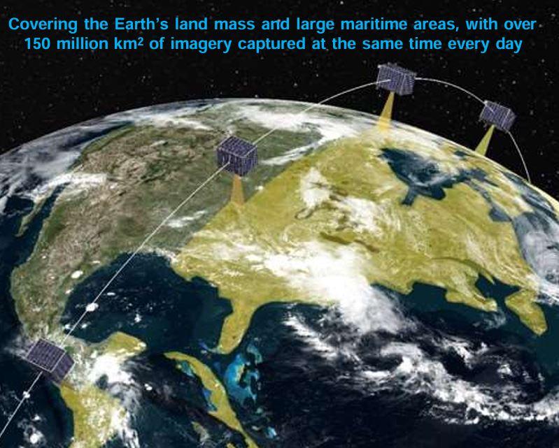
The EarthDaily Constellation consists of 10 satellites operated by EarthDaily Analytics (EDA). Over its 10-year lifetime, the commercial mission aims to provide images of the entire world on a daily basis. These images will aid in services such as agriculture, insurance, and disaster prevention and recovery.
EarthDaily originated from efforts to bring science-grade Earth observation data to the commercial sector. EarthDaily Analytics (EDA), founded in 2021 in Vancouver, Canada, evolved from assets acquired from UrtheCast, a company focused on space-based video and medium-resolution imaging. Building on this legacy, EDA developed a new satellite system delivering high-quality, multispectral imagery on a consistent global scale.
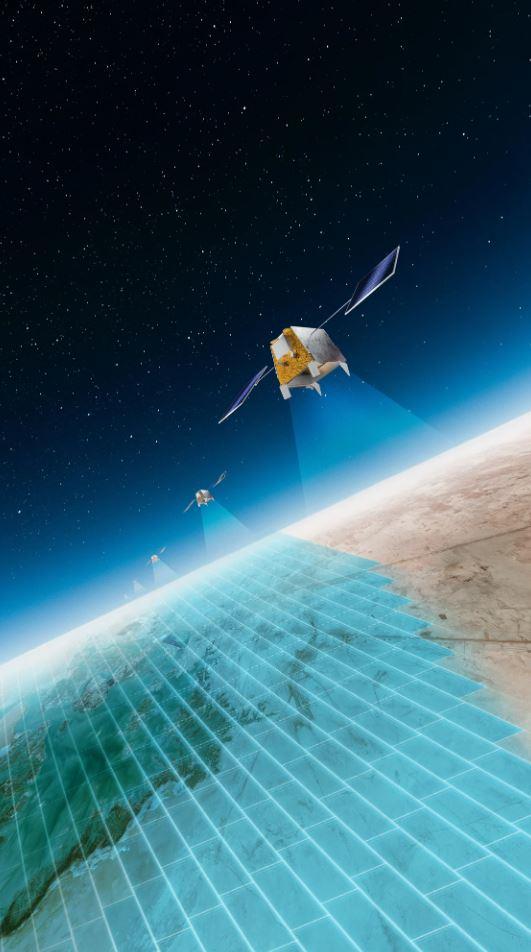
Unlike taskable high-resolution satellites, EarthDaily is designed as a daily-monitoring platform optimized for detecting surface changes over time and enabling scalable analytics. The 10 satellites work in concert to image the entire Earth’s landmass every 24 hours, under consistent lighting and viewing conditions. Combining high revisit frequency with broad spectral coverage and strict radiometric calibration, EarthDaily bridges scientific missions and commercial services.
Key technology partners include Asea Brown Boveri (ABB) Measurement & Analytics, who provide the multispectral imaging payloads, and Loft Orbital who supply the Longbow platform, which is based on Airbus Arrow’s modular, flight-proven bus. Use of off-the-shelf components and cloud-native processing enabled rapid development and cost-effective deployment. EarthDaily addresses rising demand for imagery supporting climate resilience, sustainability, agriculture, and disaster response, emphasizing automation and AI-driven actionable insights. 10)
Figure 2: EarthDaily Analytics introducing the EarthDaily Constellation. (Video credit: EarthDaily)
Science Objectives
EarthDaily’s primary goal is to provide daily, consistent multispectral imagery suitable for automated large-scale monitoring and analysis of the Earth’s land surface. It aims to detect and quantify changes in vegetation, water bodies, urban areas, and other surface features to support science and operational decision-making.
With 21–22 spectral bands spanning visible to thermal infrared, the mission enables detailed monitoring of vegetation health, surface temperature, soil moisture, and water quality.
Key application domains include:
- Agriculture: crop health monitoring, early stress detection, yield forecasting
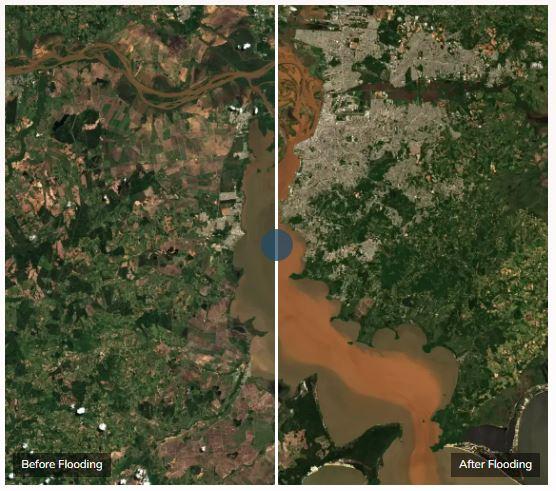
- Disaster resilience: flood and wildfire detection, damage assessment, recovery tracking
- Environmental monitoring: deforestation, land use change, coastal analysis, carbon accounting
- Infrastructure and insurance: risk modeling, urban development, asset inspection
- Climate and sustainability: ESG reporting and carbon market verification
A fixed viewing geometry and daily revisit ensure consistent illumination and minimal atmospheric variation, enabling reliable time-series and AI-based analytics. 10)
Spacecraft
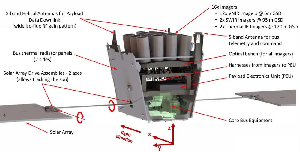
The EarthDaily Constellation 10 identical spacecraft are all based on the Loft Orbital Longbow platform, and leveraging the flight-proven Airbus Arrow bus. The modular design allows for efficient mass production, streamlined integration, and cost-effective deployment of the constellation. Each satellite is designed for a nominal 10-year operational lifetime, incorporating radiation-tolerant avionics, robust thermal control systems, and autonomous fault detection and recovery capabilities to ensure consistent operations over the mission duration. 11)
Constellation Configuration | 10 satellites in coordinated sun-synchronous orbits |
|---|---|
Operational Lifetime | 10 years |
Global Coverage | Complete landmass imaged daily by all satellites |
Data Acquisition Mode | Fixed nadir-pointing, multispectral imaging (visible to thermal infrared) |
Ground Segment | Cloud-native processing and delivery platform for Analysis Ready Data (ARD) |
Data Latency | Near real-time delivery via automated pipelines |
Redundancy and Reliability | Includes on-orbit spare and autonomous operations |
The satellites are three-axis stabilized and nadir-pointing during nominal imaging operations. The structure is lightweight yet rigid, optimized for accommodating a large optical payload while maintaining stability in low Earth orbit. Solar arrays are body-mounted or deployable (depending on configuration), feeding power to a regulated bus that supports both platform and payload subsystems.
Each spacecraft uses high-efficiency triple-junction solar cells coupled with lithium-ion batteries to provide continuous power during eclipse periods. The power subsystem is designed for high reliability and minimal degradation over the mission lifetime.
The satellites employ a compact propulsion system for orbit maintenance, constellation phasing, and collision avoidance maneuvers. Propulsion is also used to maintain the strict orbital geometry required for daily global coverage.
The communications subsystem supports high-rate X-band downlinks for payload data transmission and S-band for command and telemetry. Data is routed through a cloud-native ground segment for automated processing and delivery of Analysis Ready Data (ARD).
A precision attitude determination and control system (ADCS) ensures stable pointing during imaging passes. The system incorporates star trackers, gyroscopes, sun sensors, and reaction wheels, with magnetorquers for momentum dumping.
The thermal subsystem uses a combination of passive and active elements to maintain the spacecraft and payload within operational temperature limits. Radiators, heat pipes, and thermal coatings are used to regulate temperature under varying orbital conditions. 11) 13)
Platform | Loft Orbital Longbow, based on Airbus Arrow bus |
|---|---|
Mass | ~200–250 kg |
Dimensions | ~1 m × 1 m × 1.5 m (stowed, excluding solar arrays) |
Design Life | 10 years |
Stabilization | 3-axis stabilized, nadir-pointing |
Power | Triple-junction solar cells, Li-ion batteries |
Propulsion | Chemical or electric, for orbit maintenance |
Communications | X-band (payload), S-band (TT&C) |
ADCS | Star trackers, gyros, sun sensors, reaction wheels |
Thermal Control | Passive and active, radiators and heat pipes |
Orbit | Sun-synchronous, ~630 km altitude, ~10:30 LST |
Launch
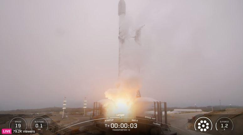
The ten satellites will be spread out evenly over the same sun-synchronous orbit. The first satellite in the EarthDaily constellation series was successfully launched aboard the Transporter‑14 rideshare mission on 23 June 2025, from Space Launch Complex 4E at Vandenberg Space Force Base in California. The SpaceX’s Falcon 9 rocket lifted off at 21:25 UTC. 7)
Orbit
The ten satellites of the constellation will be spread out evenly over the same sun-synchronous orbit, and at an altitude of approximately 630 km. 7)
Mission Status
• June 23, 2025: EarthDaily Analytics officially entered “a new era in Earth Observation” with the launch of its first satellite, YAM 10 (EDA 1, EarthDaily 1, YAC 1-1). The inaugural spacecraft successfully deployed its solar arrays, established telemetry contact, and transitioned to power-positive safe mode. That satellite lifted off aboard a SpaceX’s Falcon 9 as part of the Transporter‑14 rideshare mission from Space Launch Complex 4E at Vandenberg Space Force Base in California. 7) 8)
• September 20, 2022: The Institut National d’Optique (INO) was contracted by EDA to design and build the Thermal Camera Core Subsystems (TCCS) for the satellite constellation.
• February 16, 2022: EDA contracted the Canadian-based companies ABB and Xiphos to provide the optical imagers for the EarthDaily Constellation. ABB is developing the optical imagers and their integration method, while Xiphos will develop the high-speed electronics required to control the imagers and the data they collect.
• January 18, 2022: An $150 million dollar deal was made between EDA and Loft Orbital. Loft Orbital will build, launch, and operate the EarthDaily Constellation on behalf of EDA. The satellites will implement modified OneWeb satellite buses.
• January 11, 2022: EDA provided an update on the EarthDaily Constellation:
- Announced the completion of the detailed plan.
- Shortwave and thermal infrared cameras have been incorporated into the satellites.
- Received commitment from Antarctica Capital to support the $150 million EarthDaily Constellation.
- The EarthDaily Constellation is four months into construction.
• July 21, 2021: EDA announced plans to launch the EarthDaily Constellation:
The constellation will greatly assist Earth Observation (EO) in agriculture, forestry, environment, financial services, and defence and intelligence.
The nine satellites will observe over 21 spectral bands, many with a 5-metre resolution.
Sensor Complement
Each EarthDaily satellite is equipped with the same advanced, science-grade multispectral optical imager developed by ABB, with associated high-speed electronics from Xiphos Systems and thermal subsystems from INO (Institut National d’Optique). Each satellite carries an optical imager, which spans 22 spectral bands covering visible, near-infrared (NIR), short-wave infrared (SWIR), and thermal-infrared (TIR) wavebands. The imagery is captured at approximately 5 m spatial resolution in core visible and NIR bands. Designed for daily global coverage, the sensor offers a broad swath width of ~240 km, facilitating the imaging of almost 100% of Earth’s landmass each day.
This payload is engineered specifically for time-series analysis, change detection, and AI-enabled analytics, delivering consistent, calibrated data that surpasses standard commercial offerings in both spectral detail and revisit frequency. 11) 12)
Sensor Type | Multispectral optical imager with thermal IR capability |
|---|---|
Spectral Bands | 22 bands (Visible, NIR, SWIR, TIR) |
Spatial Resolution | ~5 m in key visible/NIR bands |
Swath Width | ~240 km |
Temporal Cadence | Daily global coverage (consistent viewing geometry) |
Primary Purpose | Science-grade, AI-ready imagery for broad-area change detection & analytics |
Data Quality Focus | High radiometric fidelity, Analysis Ready Data (ARD), calibrated and consistent |
Key Suppliers | ABB (optical imager); Xiphos Systems (electronics); INO (thermal subsystem) |
Type | Number | Observations |
Visible | 1 | Dust and smoke, water quality and organic content, ocean colour |
2 | Plant senescence and pigment, soil colour | |
3 | Plant pigments, water quality and organic content, ocean colour | |
4 | Total chlorophyll, ocean colour | |
5 | Plant pigments, soil contamination, plant growth and stress | |
6 | Plant structure, nitrogen, moisture, soil colour | |
Near Infrared (NIR) | 7 | Plant stress and fluorescence |
8 | Plant stress and fluorescence | |
9 | Plant stress and fluorescence | |
10 | Organic matter, ocean colour | |
11 | Atmospheric water absorption, crop stress and moisture | |
12 | Atmospheric water vapour | |
Shortwave Infrared (SWIR) | 13 | Atmospheric aerosols |
14 | Cloud Properties | |
15 | Snow and ice discrimination, soil moisture | |
16 | Methan reference | |
17 | Methane detection | |
18 | Wildfire detection and radiative fire power | |
Thermal Infrared (TIR) | 19 | Surface temperature, volcanoes |
20 | Surface temperature, mineral and surface composition mapping | |
21 | Surface temperature, soil and vegetation moisture, urban heat | |
22 | Surface temperature, snow grains, soil and vegetation moisture, urban heat |
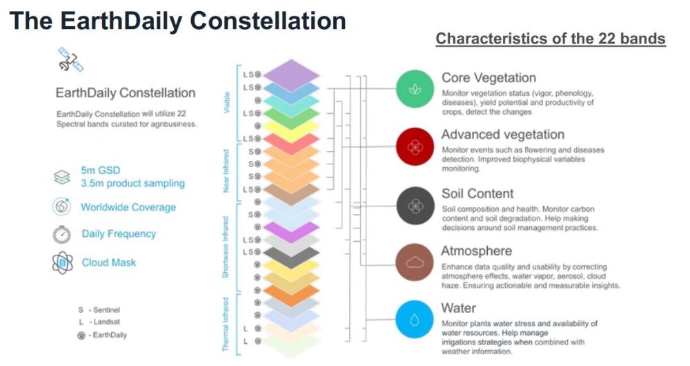
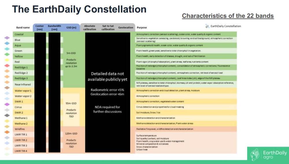
The sensor suite includes bands calibrated for vegetation health, water stress, atmospheric conditions, methane detection, wildfire monitoring, and surface temperature mapping, enabling versatile applications across agriculture, climate, and disaster response domains as shown in figure 7.
Designed for AI and ML integration, the data delivers low-noise, consistent time-series enabling automated workflows and real-time analytics via EarthPipeline. 12)
References
1) Beckett, K. (2023, May 17). EarthDaily Analytics – Calibrating and Delivering Scientific Imagery of our Planet for a Sustainable Future.
2) EarthDaily Analytics. (2021, July 21). EarthDaily Analytics Announces Timeline For The Launch Of Next Generation Satellite Constellation. Retrieved June 30, 2023, from https://web.archive.org/web/20230911051838/https://earthdaily.com/earthdaily-analytics-announces-timeline-for-the-launch-of-next-generation-satellite-constellation/.
3) EarthDaily Analytics. (2022, February 16). EarthDaily Analytics Announces Imaging Payload Providers For The EarthDaily Satellite Constellation. Retrieved June 30, 2023, from https://web.archive.org/web/20230911051900/https://earthdaily.com/earthdaily-analytics-announces-imaging-payload-providers-for-the-earthdaily-satellite-constellation/
4) Rainbow, J. (2023, January 23). EarthDaily taps loft orbital to build and operate $150 million constellation. SpaceNews. https://spacenews.com/earthdaily-taps-loft-orbital-to-build-and-operate-150-million-constellation/.
5) EarthDaily Analytics. (2022, January 11). EarthDaily Analytics Provides Strategic Update And Announces Initiation Of EarthDaily Constellation Construction. Retrieved June 30, 2023, from https://web.archive.org/web/20230911051836/https://earthdaily.com/earthdaily-analytics-provides-strategic-update-and-announces-initiation-of-earthdaily-constellation-construction/.
6) EarthDaily Analytics. (2022, September 20). EARTHDAILY ANALYTICS ANNOUNCES ADDITION OF INO AS EARTHDAILY CONSTELLATION MISSION PARTNER. Retrieved June 30, 2023, from https://web.archive.org/web/20230911051831/https://earthdaily.com/earthdaily-analytics-announces-addition-of-ino-as-earthdaily-constellation-mission-partner/.
7) EarthDaily Analytics. (2025, June 25). EarthDaily ignites a new era in Earth observation with landmark satellite launch. Retrieved June 26, 2025, from https://earthdaily.com/blog/earthdaily-ignites-a-new-era-in-earth-observation-with-landmark-satellite-launch
8) Boucher Marc, “Transporter-14 launches with five Canadian satellites”, SpaceQ, June 23, 2025, URL: https://spaceq.ca/transporter-14-launches-with-five-canadian-satellites/
9) EarthDaily, “EarthDaily Constellation: Daily Global Insights at Scale”, URL: https://earthdaily.com/constellation
10) EarthDaily, “EarthDaily Constellation Data: AI-Ready for Unmatched Insights”, URL: https://earthdaily.com/earthdaily-constellation-science-quality-data
11) Dr. Quesney Arnaud et. all, EarhDailyAgro, URL: https://thermal2023.esa.int/iframe-agenda/files/presentation-188.pdf
12) EarthDaily, “EarthPipeline, Streamline Earth Observation Data Processing“ URL: https://earthdaily.com/earthpipeline
13) Kumar Ramana, “EarthDaily Satellite Constellation,” New Space Economy – Session 2, Geospatial World India Conference, October 18, 2023. URL: https://geospatialworld.net/gsi/2023/presentations/18-oct/new-space-economy/session-2/EarthDaily-Satellite-Constellation-B-V-Ramana-Kumar.pdf