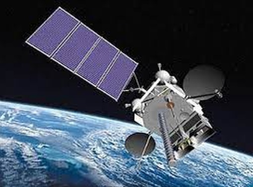
Electro-L / GOMS-2 (Geostationary Operational Meteorological Satellite-2)
EO
Atmosphere
Ocean
Cloud type, amount and cloud top temperature
Electro-L/GOMS-2 was a meteorological satellite with the purpose of providing hydro-meteorological, heliospheric, ionospheric, and magnetospheric data on the atmosphere and Earth surface. The data can be used for weather and solar monitoring and forecasting. The satellite also had an extra function in processing emergency calls.
Quick facts
Overview
| Mission type | EO |
| Agency | ROSKOSMOS, ROSHYDROMET |
| Mission status | Operational (nominal) |
| Launch date | 20 Jan 2011 |
| Measurement domain | Atmosphere, Ocean, Land, Gravity and Magnetic Fields, Snow & Ice |
| Measurement category | Cloud type, amount and cloud top temperature, Liquid water and precipitation rate, Atmospheric Temperature Fields, Radiation budget, Multi-purpose imagery (land), Surface temperature (land), Vegetation, Gravity, Magnetic and Geodynamic measurements, Surface temperature (ocean), Atmospheric Humidity Fields, Ozone, Snow cover, edge and depth, Atmospheric Winds |
| Measurement detailed | Cloud top height, Downward long-wave irradiance at Earth surface, Cloud cover, Precipitation intensity at the surface (liquid or solid), Cloud type, Cloud imagery, Fire fractional cover, Magnetic field (scalar), Magnetic field (vector), Short-wave Earth surface bi-directional reflectance, Atmospheric specific humidity (column/profile), O3 Mole Fraction, Land surface temperature, Sea surface temperature, Snow cover, Cloud top temperature, Normalized Differential Vegetation Index (NDVI), Wind profile (horizontal), Atmospheric stability index |
| Instruments | MSU-GS, DCS, GGAK-E |
| Instrument type | Imaging multi-spectral radiometers (vis/IR), Space environment, Data collection |
| CEOS EO Handbook | See Electro-L / GOMS-2 (Geostationary Operational Meteorological Satellite-2) summary |
Summary
Mission Capabilities
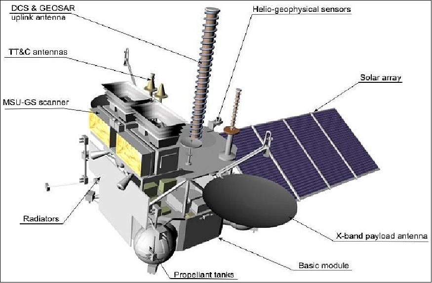
The Electro-L sensor complement consisted of four instruments.
- MSU-GS (Multispectral Scanner- Geostationary) was a 10-channel radiometer that obtained solar reflected imagery and brightness temperature measurements from the top of the atmosphere (TOA) and the Earth’s Ocean and land surface.
- GGAK-E (Helio-geophysical Instrument Complex on Electro-L) had seven components which would obtain particles to measure the sun’s X-ray radiation, the solar constant, and magnetic field components. This instrument allowed monitoring and forecasting of solar activity, radiation, and the magnetic field, as well as of the magnetosphere, ionosphere, and upper atmosphere.
- ODSS (Onboard Data Sampling System) was a system used for data collection.
- GEOSAR (Geostationary Search and Rescue System) was a complex system for the processing of emergency calls from satellite phones.
Performance Specifications
MSU-GS was imaged in three visible and seven infrared bands at a data rate of 2.56 - 15.36 Mbit/s. Its spatial resolution was 1 km in visible, near-infrared and low Middle-Wave Infrared (MWIR) bands, and 4 km in higher MWIR and thermal infrared bands.
GGAK-E had a pointing accuracy of less than 0.1° and took measurements in the spectral range of 0.2 - 100 μm. The pointing accuracy of the spacecraft as a whole was less than 0.05°, and it had an angular drift of less than 5 x 10⁻⁴ degrees per second.
Electro-L was in a geostationary orbit at an altitude of approximately 36,000 km, a longitude of 14.5°, and a nominal location of 76° East in the equatorial plane over the Indian Ocean.
Space and Hardware Components
Electro-L was three-axis stabilised and sourced its power from a deployable solar array. Radio Frequency (RF) communications were carried out through the Onboard Radio Engineering Complex (OREC) that would transmit and receive in both X-band and S-band.
The satellite’s mission ended in May 2017.
Electro-L / GOMS-2 (Geostationary Operational Meteorological Satellite-2)
Overview Spacecraft Launch Mission Status Sensor Complement References
Electro-L is an approved geostationary meteorological mission under development of ROSHYDROMET / PLANETA / Roscosmos (Russian Federal Space Agency), a successor spacecraft to GOMS (Geostationary Operational Meteorological Satellite), also referred to as Electro-1, launched Oct. 31, 1994 (which was never brought to full operational service due to technical problems).
The overall mission objectives of Electro-L are:
• To provide on an operational basis multispectral imagery (hydro-meteorological data) of the atmosphere (including the cloud-covered sky) and of the Earth's surface within the coverage region (visible disk) of the spacecraft
• To collect heliospheric, ionospheric, and magnetospheric data
• To provide the needed communication services for the transmission/exchange of all data with the ground segment
• To provide the services of data collection for the DCPs (Data Collection Platforms) in the ground segment as well as to provide the services of COSPAS/SARSAT.
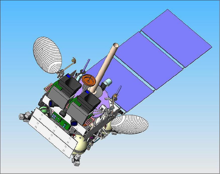
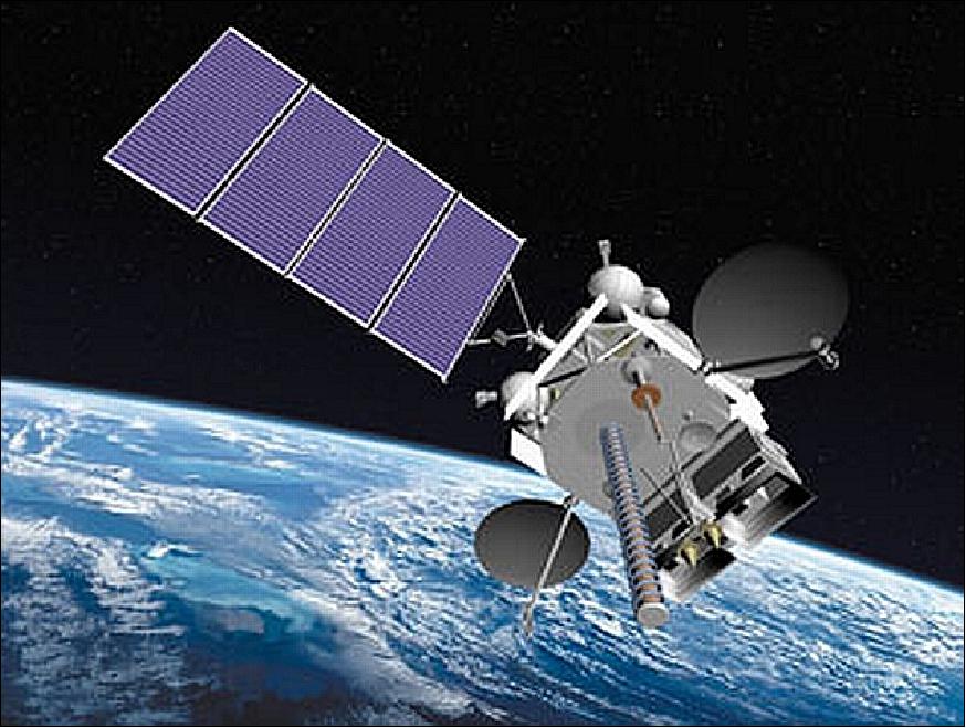
Spacecraft
The Electro-L spacecraft is being designed and built by the NPO Lavochkin Research and Production Association of Moscow. The spacecraft employs the so-called "navigator" platform, a general-purpose bus which is three-axis stabilized.
A pointing accuracy of < 0.05º is provided; the angular drift is < 5 x 10⁻⁴ º/s. A deployable solar array provides a power of 1.7 kW (EOL, the mean power consumption of the S/C is about 700 W).
The total mass of the spacecraft is about 1500 kg (payload mass of 370 kg). The S/C design life is 10 years. 1) 2) 3) 4) 5)
Launch
The Electro-L No 1 spacecraft was launched on January 20, 2011, on a Zenit-2 launch vehicle with a Fregat-SB booster from the Baikonur Cosmodrome, Kazakhstan. 6) 7)
Orbit: Geostationary orbit at the nominal location of 76º East (in the equatorial plane over the Indian Ocean).
OREC (Onboard Radio Engineering Complex). The objectives of the RF communication system are to provide all data transmission, relay, and retransmission services with the ground segment. These consist of the following functions:
• The sensor data downlink to CPPI (Ground Acquisition and Distribution Center) is in X-band (7.5 GHz) at a data rate of 2.56-15.36 Mbit/s
• Data reception from ground segment DCPs at 400 MHz (UHF), or DCP data relayed via LEO satellites at a frequency of 470 MHz. This data is transmitted from Electro-L to the CPPI in S-band at 1.7 GHz.
• Onboard reception of processed hydro-meteorological data products in X-band (8.2 GHz) and relay of this data in HRIT LRIT and WEFAX formats (in S-band at 1.7 GHz) to all customers
• Exchange of hydro-meteorological data and remote sensing data between regional centres in X-band (at 8.2 and 7.5 GHz) with data rates of up to 15.36 Mbit/s
• Data reception of COSPAS-S&RSAT messages at 406 MHz and retransmission of these messages at 1.54 GHz.
Mission Status
• November 2015: The Electro-L No 1 spacecraft is operational but in a degraded operational status. 10)
- MSU-GS instrument operates in the degraded mode due to technical issues onboard the spacecraft
- DCS is fully functional (300 national channels and 33 international channels)
- COSPAS-SARSAT system is functional
- GGAK instrument operates with significant limitations
- HRIT/LRIT channels are functional, but currently not in use
- When available, the data in HRIT format is distributed via SRC Planeta FTP server.
• In April 2015, the status of the Electro-L No 1 mission was identical to that stated in November 2015. 11)
• Nov. 14, 2014: The Electro-L spacecraft is in geostationary orbit at location 76ºE over the equator and continues to be used for its intended purpose with some restrictions. The orientation of the satellite is performed with stabilization engines. Even after the introduction of restrictions, the satellite camera provides monitoring of the visible disk of the Earth. 12)
- The multispectral camera (MSU-GS) of Electro-L provides the pre-programmed ability to capture images of the Earth in 10 ranges of visible and thermal infrared regions of the spectrum.
- The onboard equipment provides data on geophysical conditions in near-Earth space, performs telecommunications functions as well and to relay heliogeophysical data and information from the data-collection-platforms and ground units of the COSPAS-SARSAT system.
• The Electro-L spacecraft and its payload are operating nominally in 2014. 13) 14)
• The Electro-L spacecraft and its payload are operating "nominally" in 2013 after more than 2 years on orbit (there is still a problem with the MWIR and TIR channels). 15) 16) 17)
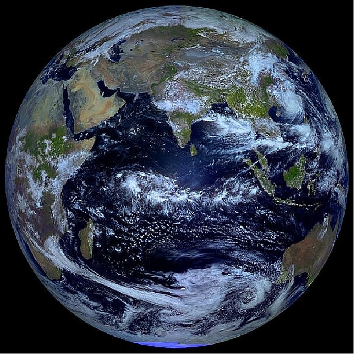
Legend to Figure 6: While Elektro-L can take photographs of the entire planet every 30 minutes, it only can get a fully-lit view like this just twice a year — at the spring and autumn equinoxes.
• In 2012, the Electro-L spacecraft and its payload are operating nominally. 18)

Legend to Figure 7: Unlike most satellite images of Earth, this one was not assembled from multiple swath scans or digitally projected onto a globe model — it's the full disk of our planet captured as a single, enormous 121-megapixel image, acquired by Russia's Elektro-L weather-forecasting satellite.
Unlike NASA/NOAA GOES satellites, Elektro-L captures images in the infrared (MWIR, TIR) as well as in the VNIR spectrum, providing detail about not only cloud movement but also vegetation variations. Its wide-angle MSU-GS (Multichannel Scanning Unit-Geostationary) imager takes images every 15-30 minutes, showing the same viewpoint of Earth across progressive times of the day.
• The commissioning phase ended in December 2011. Nominal operations of Electro-L were started in January 2012. The imager (MSU_GS) is providing images to Planeta and NTs OMZ (Research Center for Earth Operative Monitoring) every 15 minutes. The geophysical system (GGAK-E) is operational as well. 20)
• In mid-July 2011, Roskosmos announced that the testing of systems onboard the Elektro-L satellite had entered its final stage, while the trials of its ground control segment were still ongoing. Specialists were conducting test evaluations of the satellite's imagery and had completed a 10-day cycle of continuous photography. Updates to the algorithms of the image-processing software had been underway based on the produced test imagery, the agency said (Ref. 8).
• Several months into the mission, it was revealed that Elektro-L did experience a failure of one of four gyroscopic attitude control channels immediately after the launch. Although the problem was reportedly compensated for with the use of onboard sensors, the launch of the Spektr-R space observatory, which used a similar system, had to be delayed (Ref. 8).
• The Electro-L spacecraft is in the commissioning phase as of March 2011.
• The solar array deployed right after the spacecraft reached its target orbit.
• On February 3, 2011, Electro-L reached its destination at 76º E longitude over the Indian Ocean.
• Jan. 21, 2011: Electro-L with a launch on Jan. 20, 2011, shows fully nominal operations in orbit as reported by Roscosmos. The project confirmed solar array deployment and nominal operations of the satellite. 21)
Sensor Complement
MSU-GS (Multispectral Scanner- Geostationary)
MSU-GS is a 10-channel radiometer. The instrument is being designed and developed by FSUE/RISDE (Federal State Unitary Enterprise) / Russian Scientific Institute of Space Device Engineering), Moscow, Russia (note: the Russian abbreviation of FSUE/RISDE is RNIIKP).
The objectives are to obtain solar reflected imagery and brightness temperature measurements from TOA (Top of Atmosphere) and of the Earth's surface (ocean and land). In addition, the tropospheric moisture content is determined. An image of a sub-region of the disk of size yy km x zz km can be obtained in parallel. The instrument data rate is 2.56 - 15.36 Mbit/s. 22) 23)
The MSU-GS instrument is a multi-zonal scanner to take imagery in 3 visible and 7 infrared bands. In full accordance with the specifications of ROSHYDROMET, MSU-GS parameters will be close to those of the SEVIRI (Spinning Enhanced Visible and Infrared Imager) instrument now operating onboard the MeteoSat-8/MSG-1 spacecraft of EUMETSAT.
Band | Spectral range (FWHM) | Spatial resolution | NEDT at 300 K | Comment |
VNIR (µm) | 0.5-0.65 | 1 km |
| Cloud cover (solar reflective band) |
MWIR1 (µm) | 3.5-4.0 | 1 km | 0.8 | Nighttime and cloud cover |
MWIR2 (µm) | 5.7-7.0 | 4 km | 0.4 | Water vapor |
TIR1 (µm) | 9.2-10.2 | 4 km | 0.1-0.2 | SST (Sea Surface Temperature) and water vapor |
TIR2 (µm) | 11.2-12.5 | 4 km | 0.1-0.2 | SST and water vapor |
Scan angle | 20 ± 0.5º x 20 ± 0.5º | |||
SNR | ≥ 200 (for VNIR bands) | |||
Power consumption | ≤ 150 W | |||
Mass | 106 kg | |||
Design life | 10 years | |||

GGAK-E (Heliogeophysical Instrument Complex on Electro-L)
The objective of this instrument suite is to obtain particles (particle count of protons, electrons and alpha particles), to measure the sun's X-ray radiation, the solar constant, and to measure the magnetic field components for: 24)
• Monitoring and forecasting of solar activity
• Monitoring and forecasting radiation and magnetic field in the near-Earth space
• Diagnostics and monitoring of the natural and modified magnetosphere, ionosphere and upper atmosphere.
Instrument | Measured parameters | ||
SKIF-6 | 1. Differential energy spectra of low-energy electrons and protons: | ||
Range | 0.05-20.0 keV, | ||
2. Electron and proton density fluxes | |||
channel 1: | Ee ≥ 0.15 MeV | Ep ≥ 0.85 MeV | |
SKL-E | Electron and proton density fluxes | ||
channel1 1: | Ee ≥ 0.2 MeV | Ep ≥ 3.5 MeV | |
GALS-E | Proton density fluxes: | ||
channel1 1: | Ep ≥ 600 MeV |
| |
ISP-2M | Integral radiance of the Sun (integral solar constant): | ||
Spectral range | 0.2-100 µm |
| |
VUSS-E | Intensity of the solar UV radiation | ||
Wavelength | 121.6 nm (HLα-line) |
| |
DIR-E | Intensity of the soft solar X-ray radiation | ||
X-ray energy range | 3.0 - 10.0 keV |
| |
FM-E | Three components of the magnetic induction vector | ||
Magnetic induction range (for each component) | ±600 nT | ||
Legend of Table 2: Ee and Ep are the energies of electrons and protons respectively.
The GGAK-E instrument assembly has a mass of ~50 kg and a power consumption of ~50 W.
The GGAK-E instrument components are
1) SKIF-6: Corpuscular radiation spectrometer
2) SKL-E: Solar cosmic rays spectrometer
3) GALS-E: Detector of galactic cosmic rays
4) ISP-2M: Solar constant sensor
5) VUSS-E: Solar UV radiation sensor
6) DIR-E: Solar X-ray radiation flux sensor
7) FM-E: Magnetometer instrument.
Currently, only the following components are described to some degree: SKIF-6, SKL-E, GALS-E, ISP-2M, and FM-E.
Operating mode | Continuous after detecting the sun (when the instrument does not see the sun, the measurements are stopped) |
Sun tracking angles: |
|
Pointing accuracy | < 1.0º |
Sun tracking speed | not less than 2º/s |
Power consumption, instrument mass | 19 W, 12 kg |
Spectral range | 0.2 to 100 µm |
Dynamic range | 700 to 1500 W/m2 |
Accuracy of one measurement (consists of 10 counts) | 0.05% |
Accuracy of the mean day value | 0.01% |
FM-E, the digital ferro-sonde magnetometer, measures three components of the magnetic induction vector. It consists of a 3-component ferro-sonde sensor, a 3-channel analogue electronic unit, a digital data collection system on the basis of sigma-delta modulators, and an isolated secondary power supply source.
Magnetic induction range (for each component) | ±600 nT |
Temperature coefficient | 10-5 |
Null level | within ±5 nT |
Relative accuracy | 0.01% |
Measurement (or sampling) rate | 16 vectors/s |
Working temperature range |
|
Power consumption | < 3 W |
Instrument size |
|
Instrument mass | 0.5 kg (sensor unit), 2.5 kg (electronic unit) |
Working resource | > 120,000 hours |
Failure-free operation probability | > 0.95 |
ODSS (Onboard Data Sampling System)
ODSS is a data collection system provided by ROSHYDROMET, Moscow.
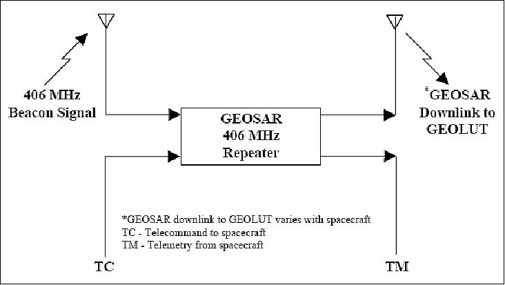
GEOSAR (Geostationary Search & Rescue) System
GEOSAR is of COSPAS-S&RSAT for emergency calls.
The repeater is redundantly configured and consists of the following units: 25)
• two 406 MHz low-noise amplifiers (shared with another satellite subsystem)
• two dual conversion 406 MHz receivers
• two 4 W phase modulated 1.5 GHz transmitters
• one 406 MHz receive antenna
• one 1544.5 MHz transmitter.
The 406 MHz signals from 406 MHz beacons are received by the antenna and fed through the diplexer and switch to a low-noise amplifier. The low-noise amplifier output is connected to the S&R receiver. The signal is down-converted for bandpass filtering in accordance with one of two commendable bands with modes; a narrow band mode of 20 kHz or a wide band mode of 80 kHz.
The filtered output signal is further down-converted to the near baseband and fed through amplifiers to the S&R transmitter. The overall gain of the S&R receiver can be command selected into a fixed gain or Automatic Gain Control (AGC) mode.
The S&R transmitter phase modulates the signal 1544.5 MHz and amplifies the modulated carrier to 4 W. The phase-modulated signal has the nominal modulation index set such that the carrier suppression is 3 dB with the receiver in the AGC mode. A baseband limiter restricts the modulation index from exceeding 2 radians. The transmitter output is applied through a 4 MHz bandwidth filter to an antenna.
Note: Throughout this documentation the terminology of GEOSAR and S&RSAT are being used instead of the "GEOSAR" and "SARSAT" terms (as introduced in the literature) - in order to avoid confusion with the acronym SAR (Synthetic Aperture Radar) which is frequently being used in Earth observation programs.
No | Parameter | Unit | Value |
1 | Nominal input level at Antenna | dBW |
|
2 | System noise temperature (referred to LNA) | K |
|
3 | G/T | dB/K |
|
4 | Receiver bandpass characteristic: | kHz |
|
5 | Dynamic range | dB | ≤ 15 |
6 | Group delay (over 4 kHz) | µs | ≤ 13 |
7 | Image rejection | dB | 60 |
8 | AGC time constant | ms | ≤ 40 x10-9 |
9 | Frequency stability | dB | ±1 x10⁻⁹ |
No | Parameter | Unit | Value |
1 | Center frequency | MHz | 1544.5 |
2 | Output power of transmitter | dBW | 6.0 |
3 | Repeater EIRP (Effective Isotropic Radiated Power) | dBW | 18 |
4 | Phase jitter (in 50 Hz bandwidth) | degree | ≤ 10 rms |
5 | Modulation type |
| Linear phase |
6 | Transmitter nominal modulation index | radian | 1.0 (peak) |
7 | Modulation index limit | radian | 2.0 |
8 | Frequency stability |
| ± 2.5 x 10⁻⁶ |
9 | Amplitude ripple (over any 24 hour) | dB | ± 1 |
S&R antennas:
• The S&R receive antenna is right-hand circularly polarized (RHCP) with an on-axis gain of 15 dB including line loss. The receive antenna has a maximum axial ratio of 3 dB
• The S&R transmit antenna is also RHCP with an on-axis gain 14 dB including line loss. The transmit antenna has a maximum axial ratio of 3 dB.
The GEOSAR repeater receives 406 MHz beacon signals within the field of view of the 406 MHz receive antenna beam. The beacon signals are processed by the repeater and transmitted on the downlink signal for reception by a GEOLUT (Geostationary Local User Terminal).
References
1) A. B. Uspensky, "Summary of Future Plans for the Russian Weather Satellite Program," ITSC-14 (International TOVS Study Conference), Beijing, May 25-31, 2005, http://cimss.ssec.wisc.edu/itwg/itsc/itsc14/presentations/session9/9_4_uspensky.pdf
2) V. V. Asmus, V. N. Dyaduchenko, O. E. Milekhin, A. B. Uspensky, "Remote Sensing Products and Applications: Roshydromet Program," Proceedings of the 2005 EUMETSAT Meteorological Satellite Conference," Dubrovnik, Croatia, Sept. 19-23, 2005, pp. 16-24, URL: http://www.eumetsat.int/groups/cps/documents/document/pdf_conf_p46_s1_03_asmus_v.pdf
3) http://bprc.osu.edu/rsl/GIIPSY/documents/Pres%20Ark%20Eng%20Vers%204.ppt
4) http://bprc.osu.edu/rsl/GIIPSY/documents/FKP_engl.ppt
5) "WMO Space Program SP-7; The Space-based Global Observing System in 2010 (GOS-2010)" WMO/TD No 1513, URL: https://web.archive.org/web/20160119123422/http://www.wmo.int/pages/prog/sat/documents/SAT-PUB_SP-7-TD-1513-Space-based-GOS-2010.pdf
6) "Russia Launches Meteorological Satellite," Space Daily, Jan. 21, 2011, URL: http://www.spacedaily.com/reports/Russia_Launches_Meteorological_Satellite_999.html
7) Stephen Clark, "Zenit rocket climbs to orbit with weather satellite," Spaceflight Now, January 20, 2011, URL: http://www.spaceflightnow.com/news/n1101/20zenit/
8) Anatoly Zak, URL: http://www.russianspaceweb.com/elektro.html
9) The Russian ELEKTRO-L Satellite Brings to the Attention of the U.S. Planetary Society," NTs OMZ, August 15, 2013, URL: http://eng.ntsomz.ru/news/news_center/center_news_2013_08_14_about_electro
10) Iurii S. Chetyrin, "Roshydromet space-based observation system: current status and development perspectives," Sixth Asia/Oceania Meteorological Satellite Users' Conference, November 9 - 13, 2015, Tokyo/Japan, URL: http://www.data.jma.go.jp/mscweb/en/aomsuc6_data/oral/s01-08.pdf
11) "Report on the status of the current and future Russian satellite system," CGMS-43 ROSH/ROSCWP-01, 14 April 2015, URL: http://www.eumetsat.int/website/wcm/idc/idcplg?IdcService=GET_FILE&RevisionSelectionMethod=LatestReleased
&Rendition=Web&dDocName=CWPT_1422
12) "About the functionality of the satellite Electro-L No1," Roscosmos, Nov. 14, 2014, URL: http://underexposure/20317/
14) "Weather Satellites," URL: http://homepage.ntlworld.com/phqfh1/status.htm
15) Sept. 23, 2013, URL: https://vk.com/electrol
16) Nancy Atkinson, "Electro-L's Fully Lit View of Planet Earth at the Autumnal Equinox," Universe Today, Sept. 24, 2013, URL: http://www.universetoday.com/104998/electro-ls-fully-lit-view-of-planet-earth-at-the-autmnal-equinox/
17) Vitaliy Egorov, "Beautiful science by Electro-L," August 8, 2013, URL: http://www.planetary.org/blogs/guest-blogs/2013/20130723-beautiful-science-by-elektro-l.html
18) "Weather Satellites," URL: http://homepage.ntlworld.com/phqfh1/status.htm
19) Jason Major, "From Russia With Love: A Singularly Stunning Image of Earth," Universe Today, May 12, 2012, URL: http://www.universetoday.com/95108/from-russia-with-love-a-singularly-stunning-image-of-earth/
20) Information provided by Yura Gektin (PI of the MSU-GS instrument of Electro-L), Moscow.
21) "Electro-L is Fully Operational - Roscosmos," Roscosmos, Jan. 22, 2011, URL: http://www.federalspace.ru/main.php?id=2&nid=11223
22) Yu. Gektin, A. V. Dunaev,M. V. Novikov,M. B. Smelianski,N. P. Akimov, "The multispectral scanner for a geostationary hydro-meteorologic complex «ELEKTRO-L»," Proceedings of the 31st International Symposium on Remote Sensing of Environment (ISRSE) at NIERSC (Nansen International Environmental and Remote Sensing Center), Saint Petersburg, Russia, June 20-24, 2005
23) V. V. Asmus, V. N. Dyaduchenko, O. E. Milekhin, A. B. Uspensky, "Remote Sensing Products and Applications: Roshydromet Program," EUMETSAT Meteorological Satellite Conference, Dubrovnik, Croatia, Sept. 19-23, 2005, URL: http://www.eumetsat.int/groups/cps/documents/document/pdf_conf_p46_s1_03_asmus_v.pdf
24) Information provided by Viktor M. Feigin of NTsOMZ (Research Center for Operational Earth Monitoring), Moscow, and translated by Boris Zhukov of IKI, Moscow
25) "Description of the 406 MHz Payloads used in the COSPAS-SARSAT GEOSAR System," C/S T.011, Issue 1, Rev. 6, Oct. 2010 , URL: http://www.cospas-sarsat.org/images/stories/SystemDocs/Current/t11oct28.10_completedoc.pdf
The information compiled and edited in this article was provided by Herbert J. Kramer from his documentation of: "Observation of the Earth and Its Environment: Survey of Missions and Sensors" (Springer Verlag) as well as many other sources after the publication of the 4th edition in 2002. - Comments and corrections to this article are always welcome for further updates (eoportal@symbios.space).
Overview Spacecraft Launch Mission Status Sensor Complement References Back to top