GCOM-C (Global Change Observation Mission - Climate)
EO
JAXA
Atmosphere
Ocean
Quick facts
Overview
| Mission type | EO |
| Agency | JAXA |
| Mission status | Operational (extended) |
| Launch date | 23 Dec 2017 |
| Measurement domain | Atmosphere, Ocean, Land, Snow & Ice |
| Measurement category | Cloud type, amount and cloud top temperature, Cloud particle properties and profile, Ocean colour/biology, Aerosols, Multi-purpose imagery (ocean), Multi-purpose imagery (land), Surface temperature (land), Vegetation, Albedo and reflectance, Surface temperature (ocean), Sea ice cover, edge and thickness, Snow cover, edge and depth, Inland Waters |
| Measurement detailed | Cloud top height, Ocean imagery and water leaving spectral radiance, Ocean chlorophyll concentration, Cloud cover, Cloud optical depth, Aerosol optical depth (column/profile), Cloud type, Color dissolved organic matter (CDOM), Land surface imagery, Vegetation type, Earth surface albedo, Leaf Area Index (LAI), Land surface temperature, Sea surface temperature, Ocean suspended sediment concentration, Sea-ice cover, Snow cover, Cloud top temperature, Normalized Differential Vegetation Index (NDVI), Photosynthetically Active Radiation (PAR), Fraction of Absorbed PAR (FAPAR), Snow Grain Size, Fire radiative power, Snow surface temperature, Lake Surface Temperature, Sea-ice surface temperature |
| Instruments | SGLI |
| Instrument type | Imaging multi-spectral radiometers (vis/IR) |
| CEOS EO Handbook | See GCOM-C (Global Change Observation Mission - Climate) summary |
GCOM-C (Global Change Observation Mission - Climate) Mission/Shikisai
Spacecraft Launch Mission Status Sensor Complement Ground Segment References
The GCOM-C program was approved by Japanese Space Activity Commission in December, 2009.
• The system design and EM design of GCOM-C including SGLI started in July 2009
• The SGLI PDR was over in March, 2010. The manufacturing of SGLI EM has been started.
• The CDR (Critical Design Review) of GCOM-C satellite system was held in Feb. 2013, and JAXA has started manufacturing the flight model components of GCOM-C satellite. 1)
In July 2017, the GCOM-C project received the nickname Shikisai (meaning colors in Japanese). The nickname was chosen by JAXA in a public contest. 2)
The purpose of the GCOM project is the global, long-term observation of the Earth's environment. GCOM is expected to play an important role in monitoring both global water circulation and climate change, and examining the health of Earth from space. 3)
GCOM consists of two satellite series, the GCOM-W and GCOM-C. The GCOM-C, carrying a SGLI (Second generation GLobal Imager), conducts surface and atmospheric measurements related to the carbon cycle and radiation budget, such as clouds, aerosols, ocean color, vegetation, and snow and ice. The GCOM-W, carrying an AMSR2 (Advanced Microwave Scanning Radiometer 2), observes water-related phenomena including precipitation, water vapor, sea surface wind speed, sea surface temperature, soil moisture, and snow depth. Global and long-term observations (10 -15 years) by GCOM will contribute to an understanding of water circulation mechanisms and climate change.
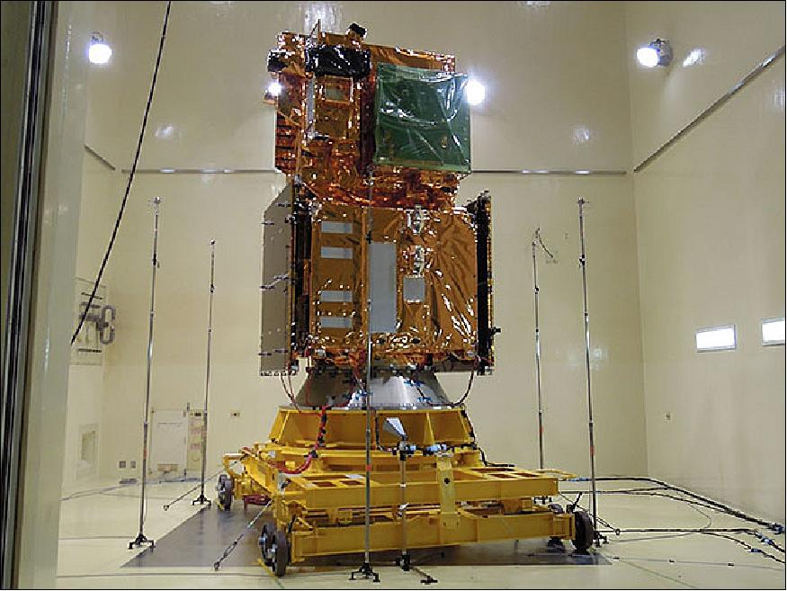
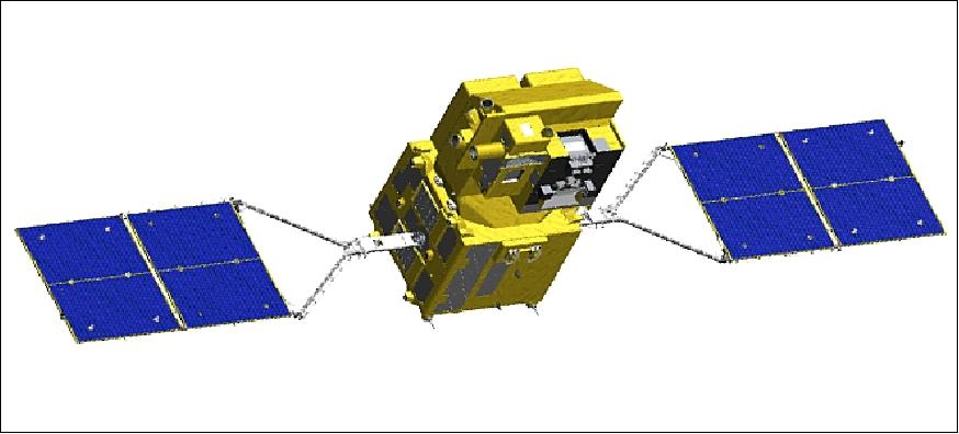
Spacecraft
The GCOM-C spacecraft is 3-axis stabilized. Power of > 4.25 kW is provided at EOL (End of Life). The spacecraft on-orbit dimensions are (deployed configuration): 4.6 m (X) x 16.3 m (Y) x 2.8 m (Z).
The spacecraft has a mass of about 2093 kg at launch (dry bus mass of 1374 kg, propellant mass of 176 kg, SGLI mass of 400 kg). The satellite generates power of 4 kW. The design life is 5 years.
Launch
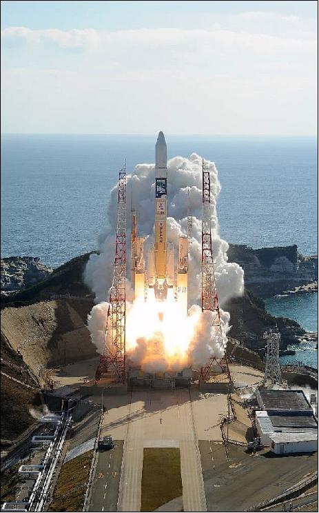
The GCOM-C spacecraft was launched on 23 December 2017 (01:26:22 UTC) on an H-IIA vehicle from the Yoshinobu Launch Complex at TNSC (Tanegashima Space Center), Japan. The launch provider was MHI (Mitsubishi Heavy Industries, Ltd). 5) 6) 7)
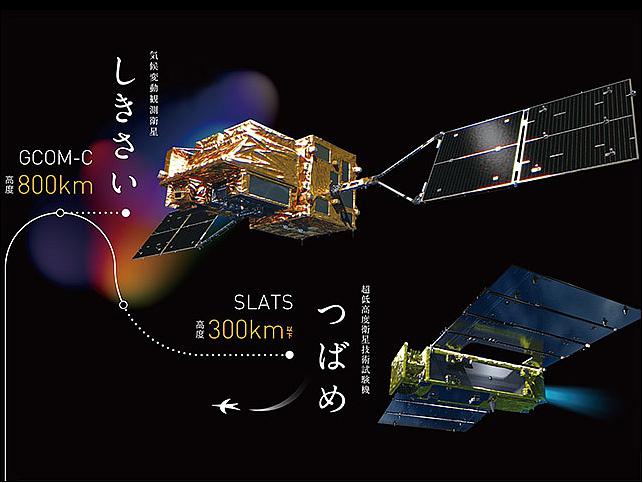
H-IIA launch vehicle No. 37 incorporates JAXA's newly developed technology to insert GCOM-C/Shikisai and SLATS/Tsubame into different orbital altitudes, respectively. It will expand opportunities of multiple satellite launch and take full advantage of the capability of H-IIA.
Orbit of GCOM-C: Sun-synchronous orbit, altitude = 798 km, inclination of 98.6º, LTDN (Local Time on Descending Node) at 10:30 hours.
RF communications: The S-band is used for TT&C data transmission: TT&C data rates at 29.4 kbit/s (USB), 1 Mbit/s (QPSK,) and 1.6 kbit/s in SSA (S-band Single Access). Command data rates: 4 kbit/s (USB), 125 kbit/s (SSA). The payload data downlink in X-band (8105 MHz) with a data rate of 138.76 Mbit/s, modulation = OQPSK (Offset Quadrature Phase Shift Keying). Direct real-time downlink of payload data to receiving stations with agreement.
Real-time observation data over Japan are transmitted by X-band to JAXA's ground stations at Katsuura, or EOC (Earth Observation Center at Hatoyama, Saitama). The received data are distributed immediately after Level-1 data processing.
Global observation data observed by SGLI are transmitted in X-band to KSAT (Kongsberg Satellite Services) Station in Svalbard, Norway together with some HK data. KSAT is the commercial Norwegian company. GCOM-C transmits telemetry stored in the onboard recorder at relatively fast data rate of 1Mbit/s to KSAT/Svalbard by S-band/QPSK..
Secondary Payload
• SLATS/Tsubame, a minisatellite of JAXA with a launch mass of 400 kg.
- The launch vehicle will insert the SLATS/Tsubame minisatellite into a lower orbit of ~ 500 km.
Mission Status
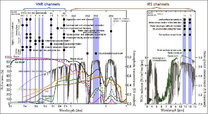
• March 1, 2019: The onboard sensor SGLI (Second Generation Global Imager) can observe 19 bands of radiations from near-ultraviolet to thermal infrared region (380 nm-12 µm), which yield various physical properties related to cloud, water, snow, ice, aerosol, sea, land, vegetation, biomass, chlorophyll a, and photosynthesis. The spatial resolution and swath of SGLI are 250 m and greater than 1,000 km, respectively; the whole globe can be scanned approximately in every two days. 8)
- SGLI can observe 15 Essential Climate Variables (ECV) such as cloud, aerosols, vegetation, etc. and its data are expected to contribute to improve the projection accuracy of climate change and also to predict fishing grounds, yellow sands, red tides, etc.
- The released products can be downloaded via JAXA G-Portal (https://gportal.jaxa.jp/)
• December 25, 2018: JAXA released the GCOM-C/SGLI products on December 20th, 2018. The products cover the terrestrial, atmosphere, ocean and cryosphere and so on. 9)
- GCOM-C/Shikisai was successfully launched on December 23, 2017 from Tanegashima Space Center. Initial function verification and initial calibration and validation of the satellite and Second-generation Global Imager (SGLI) have been completed and GCOM-C/SGLI products were released.
- JAXA started the observation with SGLI in January 2018 and continues its nominal observation operation.
- JAXA plans to reprocess the past GCOM-C/SGLI products and provide products for the entire observation period by the end of June 2019. To check the reprocess plan, please refer to here.
- JAXA has also provided the Product information/operation and Tools/documents.
• October 23, 2018: The GCOM-C mission entered and completed its in-orbit checkout phase, during which the science instruments and satellite systems are evaluated. The in-orbit checkout mission was through by March 2018, ensuring the product verification. The sample data of the GCOM-C standard product is now available on JAXA's G-Portal (Global Portal System). 10)
• August 3, 2018: JAXA has undertaken the initial checkout and calibration (i.e., verification with ground-based data) of GCOM-C/Shikisai to start the satellite-derived data stream service in December 2018. The operation of the Shikisai satellite has been nominal since the launch on December 23, 2017. On July 25, JAXA started the test stream service measures and has provided Japan Fisheries Information Service Center (JAFIC) with three types of nearly real time data including sea surface temperature. 11)
- Observation images from Shikisai can yield higher resolution images compared with other Earth observation satellites which provide data used for fisheries. Additionally, the satellite's multiple remote sensing, capable of simultaneous observation of ocean color and water temperature, will make the data applicable both to fisheries and marine research. Sea surface temperature in the fishing grounds and other detailed information pertaining to marine environment are expected to advance searching for productive fishing grounds. Data from Shikisai is also expected to enhance the monitoring of coastal environment, making it possible to observe seaweed beds, tidal flats, and algal blooms. It will contribute to the management of coastal marine resources and studies.
- JAFIC will cooperate with JAXA in calibration and verification of the data by supplying on-site surface temperature and other data. The Center will also use the test data distribution to implement the service that provides information with stakeholders such as those engaging in commercial fishing and research institutions. JAXA will use on-site measurements for comparison provided by JAFIC and other sources and continuously ensure the ongoing checkout and calibration of the satellite.

• GCOM-C/Shikisai got into steady state operation from 28 March 2018. 12)
• March 23, 2018 (updated July 3 2018): The SGLI (Second Generation Global Imager) instrument aboard the JAXA satellite Global Change Observation Mission-Climate (GCOM-C) is an optical sensor capable of observations at wavelengths ranging from near ultraviolet to thermal infrared (380 nm to 12 µm). SGLI is optimized for polarimetric performance both front and back at red and near infrared wavelengths. Polarimetric measurement can provide data that helps researchers study the properties of light including the oscillation direction of electromagnetic waves, in addition to the magnitude of light. 13)
- These features are expected to characterize aerosols, particulate matter on Earth's surface more accurately. In the ultraviolet-visible-near infrared spectra, the surface reflectance is lower over land than over ocean. Vegetation and land cover affect the space based measurement, resulting in varied readings. Identifying types of aerosol only at the wavelengths is therefore hampered by difficulties.
- However, in the SGLI wavelength regions, the reflectance of the Earth's land is significantly lower. Compared with unpolarimetry, polarimetry is less susceptible to the glare from sunlight reflecting off Earth's surface in the ultraviolet-visible-near-infrared wavelength range. These factors are thought to improve the accuracy of the measurement, enabling to detect the properties of the tiny particles of the atmosphere and to measure the composition and other details of aerosols.

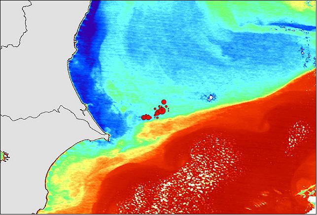
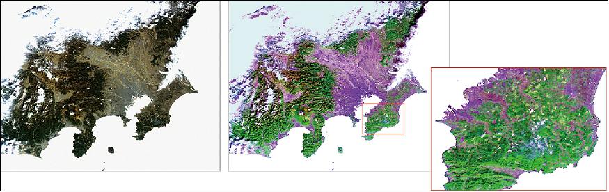
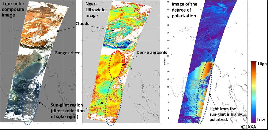
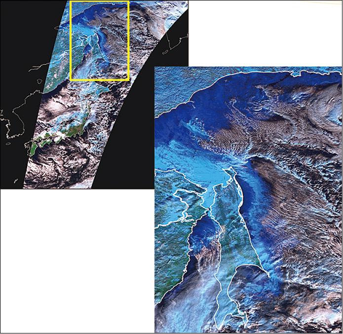
• January 12, 2018: JAXA has released some sample observation first-light images of Earth acquired with the GCOM-C/Shikisai mission. Evergreen forests are seen in dark green in the true color image and cannot be discriminated, while in the false color image, evergreen forests are clearly visible in bright green colors (Figure 7). On the other hand, small yellow patches are seen in the enlarged false color image in the lower right of Figure 7. These are golf courses covered with faded grasses on winter. 14) 15)
- Aerosol images over the Ganges river (Figure 8).
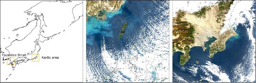
- GCOM-C/Shikisai images of ocean color around Japan (Figure 9).
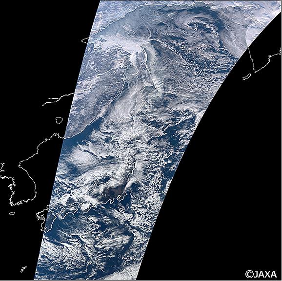
- GCOM-C/Shikisai images of the Okhotsk Sea Ice, Japan (Figures 10 and 11).
- The project will continue the initial functional verification (for about three months after launch,) then confirm data accuracy by comparing it with observation data acquired on land, and perform initial calibration and inspection operations including data correction.
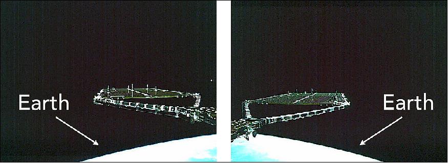
• December 24, 2017: JAXA received telemetry data from GCOM-C /SHIKISAI and SLATS/TSUBAME, confirming that their satellite attitude control system had transitioned to the steady state. The current status of both satellites is stable. 16)
- Subsequently, the following procedure occurred – power generation that supports the satellites' operation by the deployed solar array wings, ground communications and sound attitude control that maintains those operations. Combined by the completion of the series of other operations, such as powering up of the bus and mission equipment, the satellites have entered the state where they can be sustained in orbit. This concludes their critical operations phase.
- SHIKISAI and TSUBAME will move on to the next operations phase, where the functions of the satellites' onboard apparatus will be examined approximately in the next three-month period.
- JAXA conveys deep appreciation for the support by all for the satellites' launch and tracking.
• The reception of telemetry data from JAXA's SHIKISAI satellite was made at 10:44 a.m. (JST, or 19:44 UTC) at the JAXA Mingenew Station, Australia, confirming SHIKISAI's solar array deployment above Australia. 17)
Sensor complement
SGLI (Second-generation Global Imager)
SGLI is an advanced multi-purpose visible/infrared (VNIR, SWIR, TIR) imager of GLI heritage, flown on ADEOS-II. The objective is to measure ocean color, SST (Sea Surface Temperature), land use and vegetation, snow and ice, clouds, aerosols and water vapor, etc. 18) 19)
• The prime goal of SGLI is to retrieve global aerosol distributions. To achieve this target, SGLI will have 2 polarization channels with 3 directions
• SGLI is mainly focused to land and coastal areas. There are 11 channels with an IFOV of 250 m. GLI on ADEOS-II had only 6 channels of 250 m resolution.
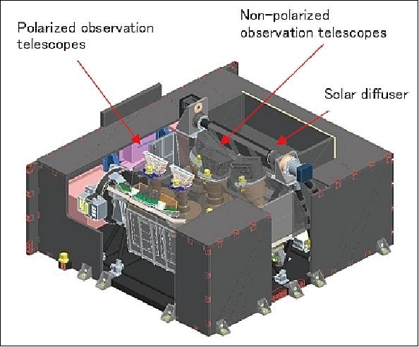
The SGLI assembly features two separate sensors (radiometers) labeled VNIR (Visible Near Infrared) and IRS (Infrared Scanner). Note, the VNIR device is also referred to as VNR in the text.
• VNIR is a pushbroom instrument providing 14 channels in the VNIR spectral region (actually also in the UV), 11 channels are termed VNIR-NP (VNIR Non-Polarized), and 2 channels are called VNIR-P (VNIR-Polarized). The VNIR-P channels of the polarimeter provide 3 polarization angles at: 0º, 60º, and 120º.
The VNIR-NP channels are divided into three 24º pushbroom type telescopes configured in the cross-track direction to realize the wide FOV (70º) requirement with wide spectral range (380 nm to 865 nm). Each telescope has refractive telecentric optics and 11 channels CCD on which the '11 channel bandpass filter assembly' is mounted. 20)
To realize the VNIR-P polarization observation, three linear polarization channels (0º, 60º and 120º) are set for two pushbroom telescopes which are dedicated for 670 nm and 865 nm observation. A tilting operation around the Y-axis of ±45º is required for VNIR-P to observe aerosols (scattering angle requirement). The scattering angle observation is calculated using the satellite orbital position, sun and observation target direction. A scattering angle direction between 60º and 120º is required for the aerosol retrieval over the land surface.
• IRS is a whiskbroom type scanning radiometer (mechanical method) covering the SWIR (Shortwave Infrared) and TIR (Thermal Infrared) spectral regions.
SGLI has a capability of simultaneous nadir and slant observations. In addition, the sensor has a capability of along-track multiangle observation. A chance of multi-angle observations on forest areas with less cloud influence will increase comparisons with cross- track observations. In the GCOM –C1 project, global AGB (Above Ground Biomass) data will be provided as a standard product that is estimated by taking advantage of the multiangle observation capability.

The key VNIR observation channels such as 670 nm and 865 nm are being observed with both low and high dynamic range independently according to the requirements (Table 2). The total spectral channels for SGLI are optimized to 19 channels including tilting polarization observation (there were 36 channels for GLI instrument). On the other hand, the SGLI standard products are increased from 22 products of GLI to 29 products.
The basic IFOV (Instantaneous Field of View) is set to 250 m - compared to GLI's 1 km requirement. Using this higher resolution with a wide FOV (1150 km for VNR and 1400 km for IRS), it is expected that the human activity influence on Earth's environment can be studied.
Scanning method | - Pushbroom scanning in the VNIR spectral region - Whiskbroom scanning in the SWIR and TIR spectral region |
Observation channels | - 11 channels in VNIR-NP (non polarized) from 380-865 nm |
Swath width | - 1150 km (for all VNIR channels) |
FOV | - 70º for VNIR-NP pushbroom scanning |
IFOV (Instantaneous Field of View) | - 250 m for all VNIR channels except VNIR9 (1000 m) |
Data quantization | 12 bit |
Polarization | 3 polarization angles for VNIR-P |
Observation direction | Along-track 0º, 45º and -45º for P |
Absolute calibration accuracy | VNR: ≤ 3% |
Channel | Center wavelength λ (nm) | Δλ (nm) | IFOV (m) | Lλ (standard radiance) | Lmax (max. radiance) | SNR (Signal-to-noise ratio) |
VNIR1 | 380 | 10 | 250 | 60 | 210 | 250 |
VNIR2 | 412 | 10 | 250 | 75 | 250 | 400 |
VNIR3 | 443 | 10 | 250 | 64 | 400 | 300 |
VNIR4 | 490 | 10 | 250 | 53 | 120 | 400 |
VNIR5 | 530 | 20 | 250 | 41 | 350 | 250 |
VNIR6 | 565 | 20 | 250 | 33 | 90 | 400 |
VNIR7 | 673.5 | 10 | 250 | 23 | 62 | 400 |
VNIR8 | 673.5 | 20 | 250 | 25 | 210 | 250 |
VNIR9 | 763 | 8 | 1000 | 40 | 350 | 400 |
VNIR10 | 868.5 | 20 | 250 | 8 | 30 | 400 |
VNIR11 | 868.5 | 20 | 250 | 30 | 300 | 200 |
Polarized channels | ||||||
P1 | 673.5 | 20 | 1000 | 25 | 250 | 250 |
P2 | 868.5 | 20 | 1000 | 30 | 300 | 250 |
Channel | Center wavelength λ (µm) | Δλ (µm) | IFOV (m) | Lλ | Lmax | SNR |
SWIR1 | 1.05 | 0.02 | 1000 | 57 | 248 | 500 |
SWIR2 | 1.38 | 0.02 | 1000 | 8 | 103 | 150 |
SWIR3 | 1.63 | 0.2 | 250 | 3 | 50 | 57 |
SWIR4 | 2.21 | 0.05 | 1000 | 1.9 | 20 | 211 |
TIR1 | 10.8 | 0.74 | 500 | 300 | 340 | 0.2 |
TIR2 | 12.0 | 0.74 | 500 | 300 | 340 | 0.2 |
The optical SGLI instrument is being designed and developed at NEC Toshiba Space, Tokyo, Japan. In turn, NEC Toshiba Space selected Sofradir of France to provide the infrared detectors for SGLI. As of 2008, Sofradir is providing concept studies for the cooled infrared MCT (HgCdTe)focal plane array detectors of the SGLI instrument. The two TIR arrays are centered on 10.8 and 12 µm wavelengths respectively, which are hybridized on a single readout circuit for accurate registration. 21) 22) 23)
The IRS whiskbroom scanner features six channels in the region of 1.05 µm to 12 µm (Table 3). The 45º tilted scan mirror is rotated around the X-axis continuously to realize a scan of 80º for Earth observation; in addition, the onboard calibrator (blackbody, solar diffuser, and inner light source) and deep space are being scanned on each scanner revolution. Compared with the double-sided mirror employed on GLI and MODIS, the constant incident angle to the IRS scan mirror represents an advantage for the calibration function.
The observation light is directly focused onto the focal plane using a Ritchey-Chretien type telescope without any relay optics. The infrared spectral range is divided by the dichroic filter for the SWIR and TIR regions in order to optimize the detection process.
The four SWIR channels employ an InGaAs photodiode detector array cooled to -30ºC using a Peltier thermo electronic cooler. The two TIR channels use a photovoltaic type HgCdTe (PV-MCT) detector array cooled to 55 K by a Stirling-cycle cooler. The bandpass filters corresponding to the spectral channels are mounted on the focal plane in the detector packages.
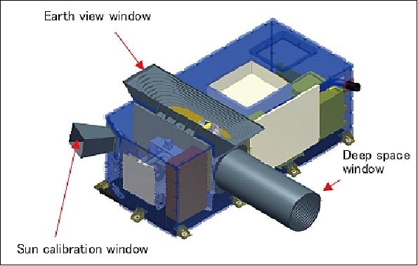
The solar diffuser (made of Spectralon), the inner light source using LEDs (Light Emitting Diodes) for the SWIR channels and a high-emissivity blackbody for the TIR channels, are used as the onboard calibrator. These calibration sources and a deep space window, arranged around the scan mirror, make it possible to obtain calibration data on every scan.
Region covered | Geophysical products | Resolution |
Land | Precise geometrically corrected image | 250 m |
Atmospherically corrected land surface reflectance | 250 m | |
Vegetation index including NDVI and EVI | 250 m | |
Vegetation roughness index including BSI_P and BSI_V | 1 km | |
Shadow index | 1 km | |
Land surface temperature | 500 m | |
Fraction of absorbed photosynthetically active radiation | 250 m | |
Leaf area index | 250 m | |
Above ground biomass | 1 km | |
Land net primary production | 1 km | |
Plant water stress trend index | 500 m | |
Fire detection index | 500 m | |
Land cover type | 250 m | |
Land surface albedo | 1 km | |
Atmosphere | Cloud flag including cloud classification and phase |
Scene: 1 km |
Classified cloud fraction | ||
Cloud top temperature and height | ||
Water cloud optical thickness and effective radius | ||
Ice cloud optical thickness | ||
Water cloud geometrical thickness | ||
Aerosol over ocean by visible and NIR (Near Infrared) | ||
Aerosol over land by NUV (Near Ultraviolet) | ||
Aerosol over land by polarization | ||
Long -wave radiation flux | ||
Short-wave radiation flux | ||
Ocean | Normalized water leaving radiance |
Coast: 250 m |
Atmospheric correction parameters | ||
Ocean photosynthetically available radiation | ||
Euphotic zone depth | ||
Chlorophyll-A concentration | ||
Suspended solid concentration | ||
Absorption coefficient of colored dissolved organic matter | ||
Inherent optical properties | ||
SST (Sea Surface Temperature) | Coast: 500 m, other: ditto | |
Ocean net primary production | Coast: 500 m, other: ditto | |
Phytoplankton function type | Coast: 250 m, other: ditto | |
Red tide |
| |
Multi sensor merged ocean color parameters | Coast: 250 m, open ocean: 1 km | |
Multi sensor merged SST (Sea Surface Temperature) | Coast: 500 m, open ocean: 1 km | |
Cryosphere | Snow and ice covered area | Scene: 250 m, global: 1 km |
Okhotsk sea-ice distribution (Note: Okhotsk is a sea lying between the | 250 m | |
Snow and ice classification | 1 km | |
Snow covered area in forest and mountain | 250 m | |
Snow and ice surface temperature | Scene: 500 m, global 1 km | |
Snow grain size of shallow layer | Scene: 250 m, global: 1 km | |
Snow grain size of subsurface layer | 1 km | |
Snow grain size of top layer | Scene: 250 m, global: 1 km | |
Snow and ice albedo | 1 km | |
Snow impurity | Scene: 250 m, global: 1 km | |
Ice sheet surface roughness | 1 km | |
Ice sheet boundary monitoring | 250 m |
Ground Segment
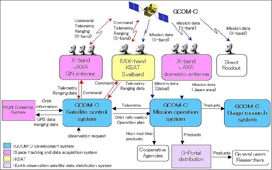
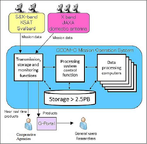
The GCOM-C ground system has many subsystems for planning the SGLI observation and satellite operation, tracking control, receiving the SGLI observation data, deriving physical quantities for a product, and distributing our products. The system overview is shown in Figure 19. 25)
System | Outline |
Satellite control | Planning satellite operation and SGLI observation |
Mission operation | Processing observation data from ground station and storing physical quantity products |
Space tracking and data acquisition | Command, telemetry and ranging operations |
Usage research | Calibration, validation and development of algorithms to derive geophysical quantities |
G-Portal data distribution | Distributing SGLI products to users |
Svalbard ground station (KSAT) | High latitude X-band ground station operated by KSAT |
The satellite control system makes the SGLI observation plane. It has a function to adjust observation requests, various constraints such as downlink plan, latency requirements and data storage. The observation plan is sent to mission operation system and used to check the completeness of the planned observations.
GCOM-C observes the Earth based on observation plan uplinked with S-band. The SGLI observation data is downlinked via the Svalbard ground station or the X-band domestic station and transmitted to the GCOM-C mission operation system in Tsukuba Space Center of JAXA. They are processed to be a product and delivered to cooperative agencies and JAXA data distribution system, G-Portal.
Observation data processing: The mission operation system is a key system for observation data processing and products transmission (Figure 20). The system control function in the mission operation system makes the products shown in Table 6 from downlinked data. At this time, the system control function can process the data in consideration of the priority. GCOM-C can use more than 3000 CPU cores and executes parallel processing. This system makes it possible to process and transmit products that satisfy the latency requirements for near-real-time products despite the complex processing flow. The products are kept in large storage more than 2.5-PB and transmitted to users.
The downlinked data are about 100 GB/day and approximately 1 TB products are handled per day. In nominal phase of operations, about 2 PB products will be made.
Level | Contents |
Level-1A | Granule scene sensor output data with geolocation and radiometric correction information |
Level-1B | Granule scene radiance data after radiometric correction and geometric correction processing |
Level-2 | Granule scene and global (tile) data of geophysical parameters derived from Level-1B or Level-2 products |
Level-3 | Spatially and temporally averaged data of geophysical parameters derived from Level-2 and Level-3 products |
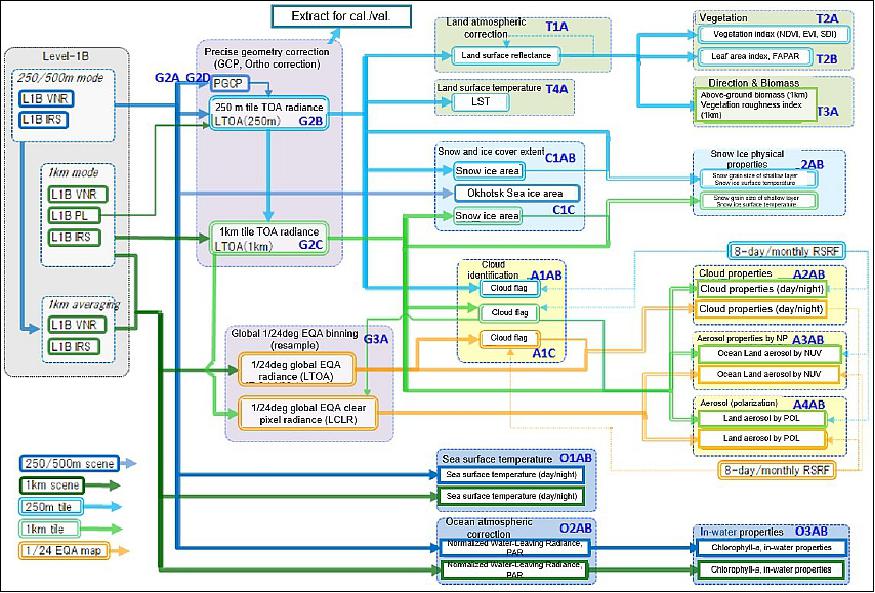
GCOM-C/SGLI products: In the level-1 processing, radiometric correction and geometric correction processing are carried out to calculate satellite observation radiance data that are input to higher-level processing. The accuracy of radiance data is maintained by reflecting the SGLI in-orbit evaluation results in the correction parameters. 26) The 28 products of physical quantities (level-2) and statistics (level-3) are made across the land, atmosphere, ocean, and cryosphere using the level-1 and the level-2 product as input. The list of the SGLI level-2 products is shown in Table 7. The processing flow of the level-2 products is shown in Figure 21. The mission operation system controls this complex flow to wait for input products, which is effective for maintaining the accuracy of higher level products.
Area | Standard Product | Product ID |
Radiance | Top-of-atmosphere (TOA) radiance | LTOA |
Land | Atmospheric corrected reflectance | RSRF |
Atmosphere | Cloud flag / Classification | CLFG |
Ocean | Normalized water leaving radiance | NWLR(L***) |
Cryosphere | Snow and ice covered area | SICE |
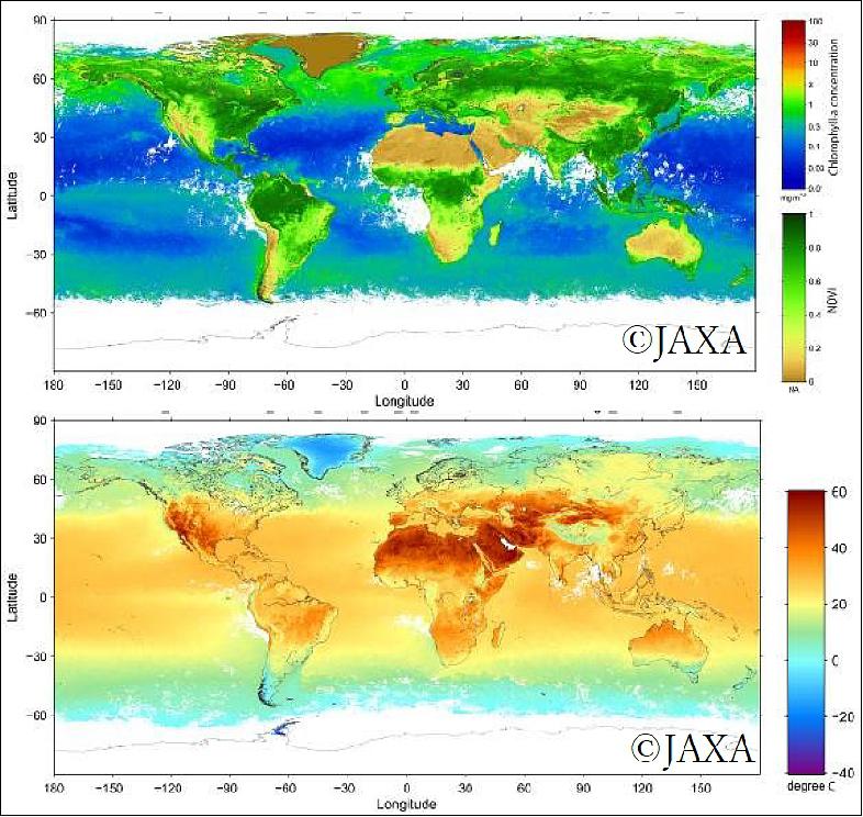
All products are transmitted to the G-Portal and stored in folders for each physical quantity and statistical period. There are many folders compared to other satellite products. There are 156 folders including near-real-time products and standard products. Figure 22 shows samples of the GCOM-C/SGLI principal products. These products are expected to be used in academic research as well as practical use related to fishery and sea passage information, and meteorological prediction.
Future updates are planned two times to improve product accuracy during the five-year mission period. The first update is scheduled in 2020.
References
1) Keizo Nakagawa, Masaaki Mokuno, Kazuhiro Tanaka, Tsuyoshi Maeda, "Development Status of GCOM-C1 Satellite System," Proceedings of the 29th ISTS (International Symposium on Space Technology and Science), Nagoya-Aichi, Japan, June 2-8, 2013, paper: 2012-n-05
2) "GCOM-C renamed SHIKISAI," JAXA, July 14, 2017, URL: http://global.jaxa.jp/projects/sat/gcom_c/
3) "GCOM-C (Global Change Observation Mission -Climate / SHIKISAI," URL: http://global.jaxa.jp/activity/pr/brochure/files/sat30.pdf
4) Keiji Imaoka + many contributors, "JAXA Earth Observation Missions," Mini-Workshop on A-Train Science, Tokyo, Japan, March 8, 2013, URL: http://suzaku.eorc.jaxa.jp/GCOM_W/materials/atrainws_mar2013/3_Imaoka.pdf
5) "Successful Launch, H-IIA Launch Vehicle No. 37 - Encapsulating SHIKISAI and TSUBAME," JAXA Press Release, 23 Dec. 2017, URL: http://global.jaxa.jp/press/2017/12/20171223_h2af37.html
6) "Launch of Global Changing Observation Mission - Climate "Shikisai" (GCOM-C) and Super Low Altitude Test Satellite "TSUBAME" (SLATS) aboard H-IIA Vehicle No. 37," JAXA Press Release, 27 October, 2017, URL: http://global.jaxa.jp/press/2017/10/20171027_h2af37.html
7) "Shikisai/Tsubame/H-IIA F37 Countdown," JAXA, URL: http://global.jaxa.jp/projects/sat/gcom_c/index.html
8) "New Dataset Release: GCOM-C/SGLI," JAXA, 1 March 2019, URL: https://global.jaxa.jp/news/2019/
9) "GCOM-C/SGLI Products Released Now!," JAXA, 25 December 2018, URL: https://gportal.jaxa.jp/gpr/notice/notice/view/943?lang=en
10) Kazuhiro Tanaka, Yoshihiko Okamura, Masaaki Mokuno, Takahiro Amano, and Jun Yoshida "First year on-orbit calibration activities of SGLI on GCOM-C satellite", Proceedings of SPIE, Volume 10781, 'Earth Observing Missions and Sensors: Development, Implementation, and Characterization V', 107810Q (23 October 2018); https://doi.org/10.1117/12.2324703
11) "Shikisai Data Stream Exploratory Measures Initiated for JAFIC," JAXA Press Release 3 August 2018, URL: http://global.jaxa.jp/press/2018/08/20180803_shikisai.html
12) Haruhisa Shimoda, "Global Change Observation Mission (GCOM)," IOVWST (International Ocean Vector Winds Science Team) Meeting, Barcelona, Spain, 24-26 April 2018, https://mdc.coaps.fsu.edu/scatterometry/meeting/past.php
13) "SGLI Polarimetric Radar Observation of Near Ultraviolet," JAXA, 23 March 2018 (updated 3 July 2018), URL: http://global.jaxa.jp/projects/sat/gcom_c/topics.html
14) "SHIKISAI Observation Data Acquired by SGLI," JAXA/EORC, Jan. 12, 2018, URL: http://suzaku.eorc.jaxa.jp/GCOM_C/monitor/gallery/20180112.html
15) "Global Change Observation Mission-Climate "SHIKISAI — color composite image of vegetation in Japan," URL: http://suzaku.eorc.jaxa.jp/GCOM_C/monitor/gallery/files/20180112_pdf01.pdf
16) "Completion of Critical Operations Phase, SHIKISAI and TSUBAME," JAXA Press Release, 24 Dec. 2017, URL: http://global.jaxa.jp/press/2017/12/20171224_shikisai_tsubame.html
17) "SHIKISAI Solar Array Deployment – Images," JAXA, 23 Dec. 2017, URL: http://global.jaxa.jp/projects/sat/gcom_c/topics.html#topics11204
18) Yoshiaki Honda, "Overview of GCOM-C1/SGLI Science," Proceedings of IGARSS (IEEE International Geoscience and Remote Sensing Symposium) 2010, Honolulu, HI, USA, July 25-30, 2010
19) Hiroshi Murakami, Masahiro Hori, Takashi Nakajima, Mitsuhiro Toratani, Teruo Aoki, Makoto Kuji, Yoshiaki Honda, "Preparation of GCOM-C1 Science Mission," Proceedings of IGARSS (IEEE Geoscience and Remote Sensing Society) 2014, Québec, Canada, July 13-18, 2014
20) Atsuo Kurokawa, Yasuhiro Nakajima, Shinji Kimura, Hiroshi Atake, Yoshihiko Okamura, Kazuhiro Tanaka, Shunji Tsuida, Kenichi Ichida, Takahiro Amano, "High-precision narrow-band optical filters for global observation," Proceedings of the ICSOS (International Conference on Space Optical Systems and Application) 2012, Ajaccio, Corsica, France, October 9-12, 2012, URL: http://icsos2012.nict.go.jp/pdf/1569607351.pdf
21) P. Chorier, A. Dariel, L. Vial, A. Poupinet, M. Vuiliermet, P. Tribolet, "Sofradir advances in Infrared detectors for Space Applications," Proceedings of the 26th ISTS (International Symposium on Space Technology and Science) , Hamamatsu City, Japan, June 1-8, 2008
22) Yoshihiko Okamura, Kazuhiro Tanaka, Takahiro Amano, Masaru Hiramatsu, Koichi Shiratama, "Design and bread-boarding activities of the Second-generation Global Imager (SGLI) on GCOM-C," Proceedings of the 7th ICSO (International Conference on Space Optics) 2008, Toulouse, France, Oct. 14-17, 2008
23) Yoshihiko Okamura, Kazuhiro Tanaka, Takahiro Amano, Masaru Hiramatsu, Koichi Shiratama, "Breadboarding activities of the Second-generation Global Imager (SGLI) on GCOM-C," Proceedings of SPIE, 'Sensors, Systems, and Next-Generation Satellites XII,' edited by Roland Meynart, Steven P. Neeck, Haruhisa Shimoda, Shahid Habib, Vol. 7106, 71060Q-1, Cardiff, UK, Sept. 15, 2008
24) Keizo Nakagawa, "Global Change Observation Mission (GCOM)," Proceedings of ISPRS (International Society for Photogrammetry and Remote Sensing) Technical Commission VIII Symposium, Kyoto, Japan, Aug. 9-12, 2010, URL: http://www.isprs.org/proceedings/XXXVIII/part8/headline/JAXA
_Special_Session%20-%201/JTS12_20100306153736.pdf
25) Yoshino Yamada, Kazuhiro Tanaka, Yoshihiko Okamura, "The achievements through 1-year GCOM-C operation after the launch," Proceedings of the 70th IAC (International Astronautical Congress), Washington DC, USA, 21-25 October 2019, paper: IAC-19-D1.5.2, URL: https://iafastro.directory/iac/proceedings/IAC-19/IAC
-19/D1/5/manuscripts/IAC-19,D1,5,2,x51888.pdf
26) Kazuhiro Tanaka, Yoshihiko Okamura, Masaaki Mokuno, Takahiro Amano, Jun Yoshida, "First year on-orbit calibration activities of SGLI on GCOM-C satellite," Proceedings of SPIE, Volume 10781, 'Earth Observing Missions and Sensors: Development, Implementation, and Characterization V', 107810Q (2018) https://doi.org/10.1117/12.2324703 , Event: SPIE Asia-Pacific Remote Sensing, 2018, Honolulu, Hawaii, United States
The information compiled and edited in this article was provided by Herbert J. Kramer from his documentation of: "Observation of the Earth and Its Environment: Survey of Missions and Sensors" (Springer Verlag) as well as many other sources after the publication of the 4th edition in 2002. - Comments and corrections to this article are always welcome for further updates (eoportal@symbios.space).
Spacecraft Launch Mission Status Sensor Complement Ground Segment References Back to Top