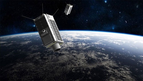
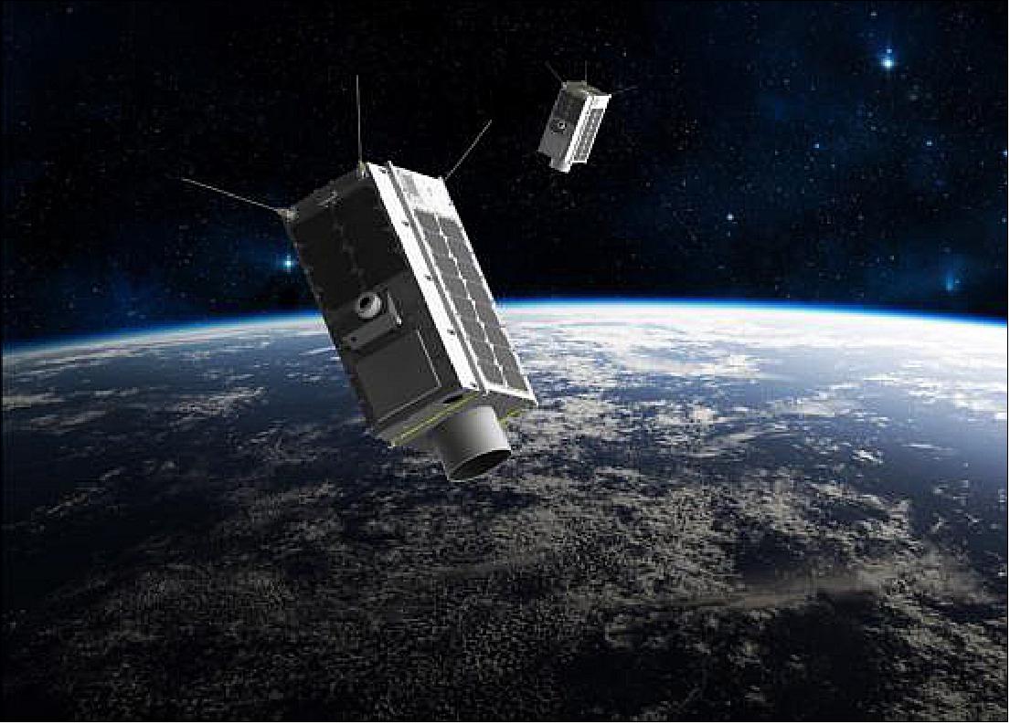
GHGSat Constellation
EO
Atmosphere
Cloud type, amount and cloud top temperature
Cloud imagery
GHGSat is a commercial constellation with the objective to become the global reference for the remote sensing of greenhouse gas emissions from any source in the world.
Quick facts
Overview
| Mission type | EO |
| Agency | GHGSat |
| Mission status | Operational (nominal) |
| Launch date | 25 May 2022 |
| Measurement domain | Atmosphere |
| Measurement category | Cloud type, amount and cloud top temperature, Trace gases (excluding ozone) |
| Measurement detailed | Cloud imagery, CH4 Mole Fraction, CO2 Mole Fraction |
| Instruments | WAF-P (CO2), VIS, WAF-P (CH4) |
| Instrument type | Imaging multi-spectral radiometers (vis/IR), Atmospheric chemistry |
| CEOS EO Handbook | See GHGSat Constellation summary |
Related Resources
Summary
Mission Capabilities
Each GHGSat carries a primary sensor, Wide-Angle Fabry-Perot (WAF-P) imaging spectrometer, and a secondary optical sensor, Visible Sensor (VIS-1). On GHGSat-D, Clouds and Aerosols Sensor (C&A-1), a lower resolution sensor, was on board in place of VIS-1.
WAF-P allows gas plumes emitted from industrial sources to be captured and distinguished from the surrounding background concentrations, constituting a differential measurement. VIS-1 and C&A-1 measure the interference from clouds and aerosols in the field of view of the WAF-P. WAF-P can only measure methane in the daytime and when its view is not blocked by clouds or other aerosols.
Performance Specifications
WAF-P is an optical imaging spectrometer that detects in the Short-Wave Infrared (SWIR) spectral range from 1600 - 1700 nm with multiple bands in a proprietary configuration. It can detect a methane column density to a precision of 1% of background and has a detection threshold of 100 kg/hour in 3 m/s of wind for methane. It has a spatial resolution of approximately 30 m with a swath width of less than 15 km. VIS-1, which replaces C&A-1 from the demonstrator, is an optical sensor that images the ground in the visible range region between 500 - 550 nm with a spatial resolution less than 20 m and a swath width less than 35 m.
GHGSat’s have altitudes ranging from 512 km to 550 km. GHGSat-D has an orbital inclination of 97.3° while the rest of the constellation has an orbital inclination of 97.5°. The orbital period of these satellites is 95 minutes with 15 orbits per day and a 14-day repeat cycle for each satellite.
Space and Hardware Components
GHGSat’s were built by the University of Toronto Institute for Aerospace Studies (UTIAS) Space Flight Laboratory (SFL). Each 15 kg satellite is based on the low-cost, high-performance Nanosatellite for Earth Monitoring and Observation (NEMO) bus. Downlink on the demonstrator was a problem as data was being produced faster than it can be downlinked to ground stations with an S-band transmitter for downlinking payload data and satellite bus telemetry at downlink rates of up to 2 Mbit/s. GHGSat-C1/C2 tested a downlink system that achieved downlink rates of up to 1 Gbit/s, designed by Sinclair Interplanetary.
The mission is currently operational, with six satellites operational and four more satellites planned for the constellation by the end of 2023. Each microsatellite has a four-year operational life.
GHGSat Microsatellite Constellation
Spacecraft Launch Mission Status Sensor Complement References
In June 2016, GHGSat-D (Claire) was launched, becoming the first high-resolution microsatellite designed to measure greenhouse gas emissions from point sources, such as industrial facilities and power plants. The bus was provided by the UTIAS/SFL (University of Toronto, Institute for Aerospace Studies /Space Flight Laboratory) under contract to GHGSat Inc. of Montreal, Canada. Claire has successfully demonstrated greenhouse gas measurements around the world, and several such measurements of methane emissions have been released publicly in the last year. In order to extend the service capability and as a precursor to a full constellation, GHGSat-C1 and GHGSat-C2 are the next two microsatellites under development. 1)
With a mass of approximately 16 kg each, the design follows its predecessor Claire in leveraging SFL’s Next Generation Earth Monitoring and Observation (NEMO) bus. Bus platform modifications such as enhanced electromagnetic compatibility and hardware redundancy will result in increased performance and reliability. Enhancements to the payload include reduced stray light, onboard calibration capability, and additional radiation mitigation. Furthermore, the inclusion of an optical downlink as a technology demonstrator will result in greater data downlink capacity. These upgrades will be entirely accomplished with the same volume and power constraints as Claire. The development of the GHGSat-C1 and GHGSat-C2 satellites is currently underway and the first of the two is scheduled for launch at the beginning of 2019.
Mission Objectives
GHGSat’s idea started with the implementation of carbon cap-and-trade programs in various Canadian provinces and US states. 2) Several provinces in Canada have carbon pricing systems in place. British Columbia has had a carbon tax in place since 2008, and Quebec and Ontario adopted a cap-and-trade system in 2013 and 2017, respectively. The vision of GHGSat is to be the global standard for emissions across the world. The GHGSat microsatellites have a different observing strategy than other satellites on orbit with the capability of detecting carbon dioxide and methane. Whereas previous satellites have had a spatial resolution on the order of kilometres, the spatial resolution of the GHGSat microsatellites is less than 50 m.
Background
The increase in the atmospheric concentration of greenhouse gases (GHG), such as carbon dioxide (CO2) and methane (CH4) is one of the factors contributing to Earth’s changing climate. Similar to other industrialized countries, in Canada carbon dioxide is the primary GHG emitted through human activities via the combustion of fossil fuels. The second highest emission is methane, sources of which include livestock, landfills, coal mines, and wastewater management. Canada takes significant steps to address climate change by implementing national plans to reduce GHG emissions and by transitioning to a clean growth economy. These goals flow down to all sectors of the economy and a report is submitted annually to the United Nations Framework Convention on Climate Change (UNFCCC) that includes estimates of the CO2 equivalent in six economic sectors, shown in Figure 1.

Spacecraft
In order to expand satellite system capacity after the successful launch of its demonstration satellite, GHGSat started the design of two (2) additional high-resolution satellites in January 2017, called GHGSat-C1 and GHGSat-C2, respectively. GHGSat-C1/-C2 are intended to have similar designs to GHGSat-D while applying critical lessons learned to improve performance. 8)
In March 2017, UTIAS/SFL (University of Toronto Institute for Aerospace Studies/Space Flight Laboratory) has been contracted by GHGSat Inc. of Montreal to develop the GHGSat-C1 and C2 greenhouse gas monitoring satellites. 9)
SFL has begun the development of the GHGSat-C1 and C2 satellites at its Toronto facility with planned launches in late 2018 and early 2019, respectively. Serving as GHGSat’s first two commercially operating satellites, they will be identical to each other but contain incremental, yet significant, enhancements from the demonstration mission.
The design phase for two new, high-resolution satellites was completed in 2017. Changes made to the payload include (Ref. 8):
• Improved stray light/ghosting mitigation
• Addition of onboard calibration features
• Improved radiation mitigation
• Optimized spectroscopy for primary instrument
• Replacement of secondary instrument
• Addition of experimental optical downlink
Overall, GHGSat expects an order-of-magnitude performance improvement from this design, within the same volume, mass and power constraints of the demonstration satellite (Ref. 1).
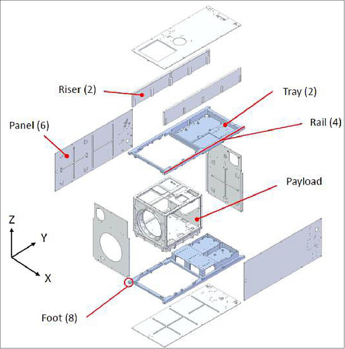
The Next Generation Earth Monitoring and Observation (NEMO) platform is SFL’s first bus designed for microsatellite missions. This standard bus consists of two trays and six panels as seen in Figure 2. This supports a main payload mass of a maximum of 6 kg with an overall spacecraft mass ranging from 10-20 kg depending on secondary payloads and optional SFL avionics required to meet current and future missions. The GHGSat-C1 will have a mass of ~16 kg.
The nominal volume is 20 x 30 x 40 cm with a peak power between 50-100 W. Higher power is achieved through optional pre-deployed solar wings. The bus design supports a main payload of volume 8000 cm3 with a payload power of up to 45 W and a 40% duty cycle.
The NEMO platform supports various ACS (Attitude Control Subsystem) sensors and actuators from sun sensors, magnetometer and rate sensors to magnetorquers and reaction wheels. This gives an ACS stability of approximately two degrees. When mission demands are higher, a star tracker can be used which increases ACS stability to about 10-60 arcseconds. The bus also supports GPS.
The typical NEMO platform uses a UHF uplink and an S-band downlink. The standard uplink rate is 4 kbit/s with a downlink rate between 32 kbit/s and 2 Mbit/s. The platform can be further enhanced to use an S-band uplink.
Depending on deployed appendages, the NEMO platform is compatible with two SFL separation systems: the XPOD Duo and XPOD Delta. These separation systems are compatible with multiple launch vehicles.
Improvements for GHGSat-C:
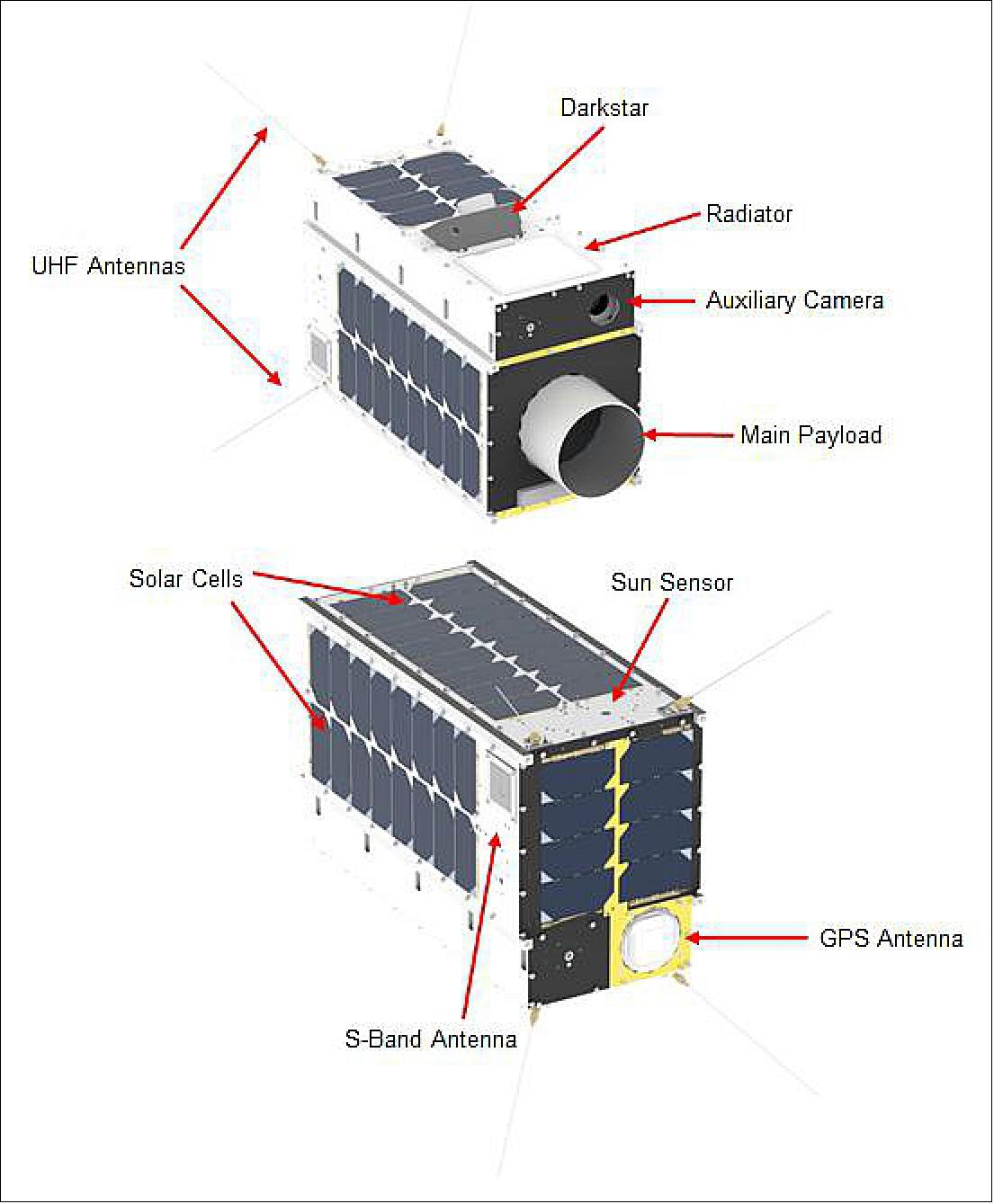
The mechanical design of GHGSat-C1/-C2 has been constrained to match the design of GHGSat-D as closely as possible. Changes have been made due to upgrades in SFL hardware, updates to the primary payload, additions of new payloads, and to decrease in the EMI sensitivity of the bus. The spacecraft exterior solid model is shown in Figure 3.
SFL Hardware Upgrades:
Several updates to the S-band transmitter have been implemented across all NEMO-class satellites to improve performance. Coaxial cables with improved shielding and filters between the transmitter and the antennas were added. These cables offer reduced insertion loss and, along with the higher-powered S-band radio that has been baselined, will increase the transmit gain allowing for increases in data transfer using just S-band communications. These improvements have been proven during ground testing of other SFL spacecraft.
Firecode functionality has also been shifted from each individual onboard computer (OBC) to a separate fire code board, which interfaces with the radio and OBCs directly. This was done to further improve resilience to radiation-induced upsets. Additional upgrades to the OBC have been made but do not affect the mechanical interfaces within the bus.
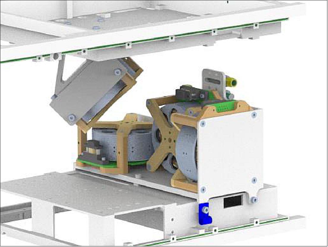
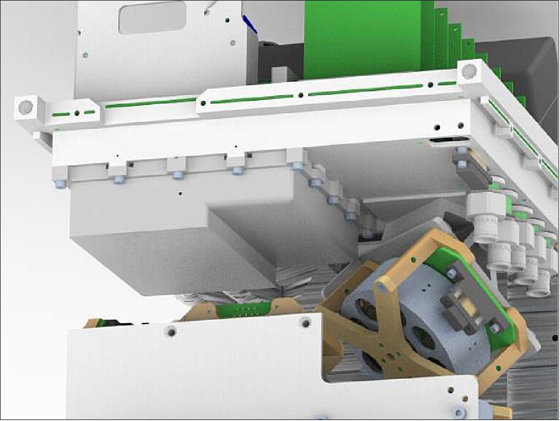
A fourth reaction wheel has been added as a redundancy. It uses a skew orientation where it has control authority in all three of the principal spacecraft axes and thus can act as a backup. Figure 4 shows the four-wheel configuration.
A permanent magnet has also been included to prevent an undesirable attitude where the payload face – one that has no solar panels – is locked in an attitude that faces the sun. This orientation would result in a power-negative state until the satellite is commanded out of that attitude or environmental disturbances cause the satellite’s attitude to drift. The magnet was sized to impart a permanent dipole to the satellite which would interact with Earth’s magnetic field inducing a torque that would prevent it from getting stuck in that “sun-stare” attitude.
Addition of New Payloads:
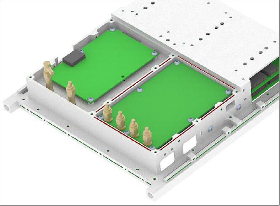
The addition of Darkstar has resulted in several changes to the GHGSat-C1/-C2 spacecraft. Mechanically speaking a new bracket needed to be designed to simultaneously ensure that the laser downlink had adequate line-of-sight to its ground station while maintaining a sufficient star tracker viewing angle to prevent impingement from the sun or Earth in nominal operations. A much larger cutout in the panel was required to accommodate this and a split panel design was implemented to facilitate both reducing the EMI sensitivity and ease of assembly as seen in Figure 5. By installing each part of the panel around Darkstar the actual size of the panel cutout was minimized reducing the effect of electromagnetic interference on the satellite avionics.
Due to frequency conflicts between the Q8 processor's high-speed data transfer connection and other spacecraft components, it was necessary to contain the board within an enclosure and shield the associated cabling to prevent undesired interferences. The addition of this payload posed some challenges because of extremely tight clearances especially with moving components such as the reaction wheels. The enclosure placement within the bus can be seen in Figure 6.
EMI (Electromagnetic Interference) Sensitivity Reduction:
To further improve the uplink sensitivity of the bus EMI gaskets were added to the primary spacecraft panels. Adjustments to the panel-to-panel and panel-to-tray interfaces were required to ensure there was sufficient material present for the gasket cutouts. Additionally, EMI gaskets were added to the UHF enclosure, as shown in Figure 7.
Future Constellation Plans:
The second and third GHGSat microsatellites will assure the continuity of observations and will expand GHGSat’s customer capacity. More satellites will enable more frequent tracking of sites. GHGSat-C1/-C2 are the first two satellites in a planned constellation of GHG monitoring satellites.
Launch
Three more microsatellites known as GHGSat-C9 (“Juba”), -C10 (“Vanguard”) and -C11 (“Elliot”), were launched at 18:49 UTC on November 11, 2023, onboard SpaceX's Falcon 9 during the Transporter-9 mission from Vandenberg Space Force Base in California. 38)
GHGSat-C10 is the first orbital sensor able to pinpoint carbon dioxide emissions from individual industrial facilities, such as cement or power plants.
Orbit
GHGSat-C9 (“Juba”), GHGSat-C10 (“Vanguard”), GHGSat-C11 (“Elliot”), have a Sun-synchronous orbit, at 500 km altitude and 97.5 ° inclination. 39)
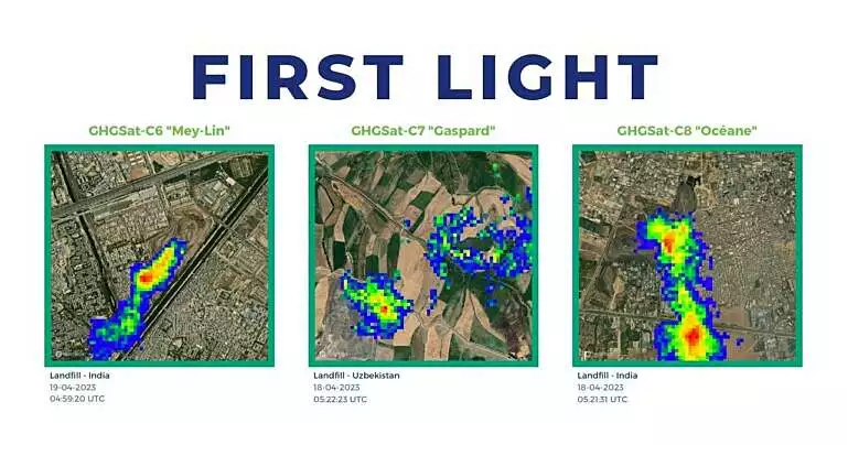
Three next-generation greenhouse gas monitoring microsatellites known as “GHGSat-C6”, “GHGSat-C7” and “GHGSat-C8”, were launched at 06:48 am UTC on 15 April 2023.
The microsatellites were launched by SpaceX onboard the Transporter-7 ride-sharing mission from Vandenberg Space Force Base in California. 32)
GHGSat-C6 (“Mey-Lin”), -C7 (“Gaspard”) and -C8 (“Océane”)
GHGSat’s Mey-Lin (C6), Gaspard (C7), and Océane (C8) lifted off on 15th April, expanding GHGSat’s constellation of high-resolution methane satellites to 9, in orbit. All three satellites separated from the SpaceX Transporter-7 vehicle around 63 minutes after launch and contact was made within 90 minutes – a new record for the Satellite Operations team.
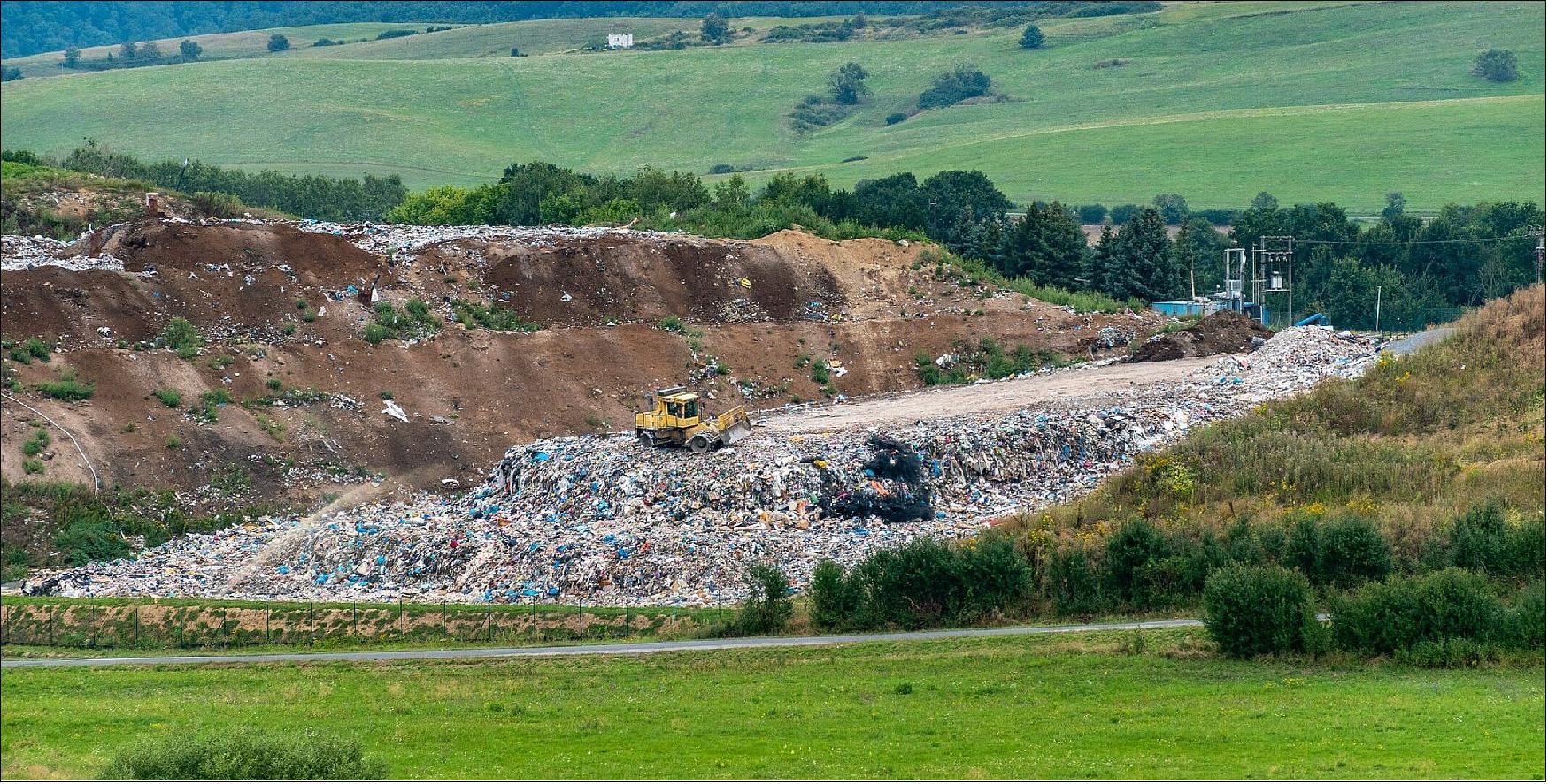
All three satellites have captured a landfill methane leak as their first detection, two sites in India and one in Uzbekistan. Landfill sites are persistent methane emitters and enable us to validate the performance of the satellites’ greenhouse gas detecting instruments. Whilst oil & gas facilities are the primary contributors to industrial greenhouse gas emissions, unregulated landfills are a known methane source and emit methane as the waste accumulates and decomposes.
- To date, GHGSat’s data-driven greenhouse emission monitoring has enabled GHGSat customers to mitigate over 10 million tons of CO2 equivalent – which is equivalent to over 2.2 million passenger vehicles being driven on roads for a year. With a further three hosted payloads currently in testing GHGSat can help their customers raise their methane emission reduction ambitions. 33)
Orbit
GHGSat-C6 (“Mey-Lin”) has 494.7 km perigee, 514.3 km apogee, 97.4 ° inclination, a period of 94.6 minutes and a semi-major axis of 6875 km.
GHGSat-C7 (“Gaspard”)has 494.4 km perigee, 514.3 km apogee, 97.4 ° inclination, a period of 94.6 minutes and a semi-major axis of 6875 km.
GHGSat-C8 (“Océane”)has 501.0 km perigee, 515.4 km apogee, 97.4 ° inclination, a period of 94.6 minutes and a semi-major axis of 6879 km.
GHGSat-C3 (“Luca”), -C4 (“Penny”), and -C5 (“Diako”)
On May 25, 2022, GHGSat has successfully completed today at 2:27 p.m. EDT (18:27 UTC) the launch of three satellites, GHGSat-C3 (“Luca”), -C4 (“Penny”) and -C5 (“Diako”) aboard a SpaceX Falcon 9 rocket from Cape Canaveral Space Force Station. This new launch brings to six the total number of its satellites in space capable of monitoring GHG emissions. 10)
- This mission comes six years after the 2016 deployment of GHGSat’s first satellite, GHGSat-D (“Claire”), and marks on the same occasion, its fourth satellite launch. GHGSat is the only industry player in the world with satellites designed for high-resolution measurements of methane emissions from industrial sites. These measurements are critical for stakeholders globally to better understand their carbon footprint and take necessary action to reduce it. Thanks to its big data infrastructure, the Montréal-based company is capable of securely and efficiently processing large volumes of data that it generates and transforming it into valuable information products for its customers.
- Through this launch, GHGSat-C3 (“Luca”), C4 (“Penny”), and C5 (“Diako”)—affectionately named after the children of GHGSat team members—have successfully joined the company’s first three satellites in orbit, thereby doubling the size of a unique constellation which has been providing accurate methane emissions data since 2016 to industrial, governmental, and financial services customers. Thanks to the support received from the Canadian government at the COP26 climate change conference last fall, GHGSat is now also providing high-resolution methane emission data to the International Methane Emissions Observatory (IMEO) under the United Nations Environment Program (UNEP).
- “Satellite monitoring of greenhouse gas emissions is critical to the fight against climate change. GHGSat is continually enhancing its ability to provide all stakeholders with the most reliable and up-to-date data and insights on emissions worldwide. We have additional launches planned to bring our constellation to ten satellites by the end of 2023,” stated Stephane Germain, GHGSat CEO.
GHGSat-C2 (Hugo)
On January 24, 2021, at 15:00 UTC, the GHGSat-C2 (Hugo) nanosatellite (16 kg) of GHGSat (Montreal, Canada) was launched as a passenger payload on the Transporter-1 rideshare mission of SpaceX (with a total of 143 satellites). The Falcon 9 lifted off from Space Launch Complex 40 (SLC-40) at Cape Canaveral Space Force Station in Florida. Onboard were also 10 Starlink minisatellites of the SpaceX Starlink constellation. 11)
Orbit:
SSO orbit of Rideshare mission: — SpaceX sent this mission with its 10 Starlink satellites into a polar SSO (Sun-Synchronous Orbit) with permission of the FCC (Federal Communications Commission). The altitude of 560 km and inclination of 97.6º 12)
The Falcon 9 rocket soared toward the southeast from the launch pad at Cape Canaveral, then vectored its thrust to fly on a coast-hugging trajectory toward South Florida, before flying over Cuba, the Caribbean Sea, and Central America. The unusual trajectory was similar to the track followed by a Falcon 9 launch in August 2020, which was the first launch since the 1960s from Florida’s Space Coast to head into a polar orbit.
GHGSat-C1 (Iris)
The GHGSat-C1 (Iris) nanosatellite was launched as a passenger payload on Vega's rideshare service flight VV16, using the Small Spacecraft Mission Service (SSMS) dispenser for light satellites, launched from Europe’s Spaceport in Kourou, French Guiana at 01:51 UTC, 03:51 CEST on 3 September 2020 (22:51 local time on 2 September in Kourou). 13)
Orbit:
Sun-synchronous orbit; target orbit for the 7 microsatellites: altitude of 515 km, inclination of 97.45º; target orbit for the 46 nanosatellites: altitude of 530 km, inclination = 97.51º. The nominal mission duration (from liftoff to separation of the 53 satellites) is 1 hour, 44 minutes and 56 seconds.
In April 2019, GHGSat announced that the firm's second satellite (namely GHGSat-C1) will be known as Iris — the naming follows a company tradition to name their satellites after the firm's team’s children as a symbol of the importance of its mission to future generations. Iris is expected to build on Claire’s success by making it possible to monitor even more sites, more frequently, at a fraction of the cost of other technologies. 14)
Passenger Payloads (53) of the Vega Rideshare Mission VV16
Arianespace has realized the first European “rideshare” mission for small satellites, with 53 satellites onboard the Vega launcher for 21 customers from 13 different countries. With this new SSMS (Small Spacecraft Mission Service) shared launch concept, Arianespace demonstrates its ability to respond – in an innovative and competitive manner – to institutional and commercial requirements of the growing market for small satellites. The total satellite launch mass was 1,327 kg. 15)
With the demonstration of its new SSMS service, Arianespace is strengthening its position in the growing market for small satellites. This service will soon be supplemented by the MLS (Multi Launch Service) – a similar offer available on Ariane 6, allowing Arianespace to increase the number of affordable launch opportunities for small satellites and constellations.
• ESAIL is a maritime microsatellite with a mass of 112 kg for AIS (Automatic Identification System) ship tracking operated by exactEarth. It was built by a European manufacturing team led by the satellite prime contractor Luxspace. ESAIL features enhanced multiple antenna-receiver configurations for global detection of AIS messages and high-resolution spectrum capture, which will enable the demonstration of advanced future services such as VDES (VHF Data Exchange System) message reception. 16)
• Lemur-2, eight 3U CubeSats built by Spire Global Inc., San Francisco, CA. These satellites carry two payloads for meteorology and ship traffic tracking. The payloads are the STRATOS GPS radio occultation payload and the SENSE AIS payload.
• TriSat is a 3U CubeSat (5 kg) imaging mission led by the University of Maribor, Slovenia. The mission is focused on remote sensing by incorporating a miniaturized multispectral optical payload as the primary instrument, providing affordable multispectral Earth observation in up to 20 non-overlapping bands in NIR-SWIR (Near to Short Wave Infrared) spectrum.
• The launch integrator company Spaceflight Inc. of Seattle WA is providing its services for four different customers with a total of 28 satellites. These are:
a) NewSat-6 (also written as ÑuSat-6), is a low Earth orbit commercial remote sensing microsatellite (43.5 kg) designed and manufactured by Satellogic S.A. with HQs in Argentina, a vertically integrated geospatial analytics company that is building the first Earth observation platform with the ability to remap the entire planet at both high-frequency and high-resolution. This is Satellogic’s 11th spacecraft in orbit, equipped with multispectral and hyperspectral imaging capabilities and it will be added to the company’s growing satellite constellation.
b) 14 Flock-4v, 3U CubeSats, next-generation SuperDove satellites of Planet Inc., San Francisco, will join its constellation of 150 Earth-imaging spacecraft.
c) SpaceBEE, 12 (.25U) picosatellites of Swarm Technology which provide affordable global connectivity.
d) Tyvak-0171, an undisclosed minisatellite of Tyvak, developed by Maxar with a mass of 138 kg.
• Planet Inc. of San Francisco launches a total of 26 Flock 4v SuperDoves on this mission. They will be split into two batches on the same launch: 14 of them will be housed inside and deployed from ISL’s QuadPack deployers and the remaining 12 will be deployed from D-Orbit’s InOrbit Now (ION) free-flying deployment platform. 17)
• Athena, a communications minisatellite mission (138 kg) of PointView Tech LLC, a subsidiary of Facebook. The objective is to provide broadband access (internet connectivity) to unserved and underserved areas throughout the world.
• AMICalSat, a 2U CubeSat, an educational mission, developed by CSUG (University of Grenoble Alpes, France) and MSU-SINP (Lomonosov Moscow State University-Skobeltsyn Institute of Nuclear Physics, Russia). The objective is to take pictures of the Northern light in order to reconstruct the particle precipitation in the polar atmosphere. The payload is a very compact, ultra-sensitive wide filed imager (f=23mm, aperture f/1.4). Firstly, AMICal Sat will observe auroras using nadir pointing, i.e. by determining the centre of the Earth to map and link the geographical position of the auroral oval and its internal structures with solar activity. Secondly, the cubesat will perform image capture ‘in limbo’ through tangential orientation with the Earth to capture the vertical profile of the auroras and match an altitude to their various emissions.
• PICASSO, a 3U CubeSat mission (mass of 3.8 kg) developed for ESA ( European Space Agency) led by BISA (Belgian Institute for Space Aeronomy), in collaboration with VTT Technical Research Center of Finland Ltd, Clyde Space Ltd. (UK) and the CSL (Centre Spatial de Liège), Belgium. The goal is to develop and operate a scientific 3U CubeSat.
• GHGSat-C1 of GHGSat Inc., Montreal, Canada, is the first of two nanosatellites (~16 kg) as the commercial follow-on to the GHGSat-D (CLAIRE) demonstration satellite developed and launched by UTIAS/SFL of Toronto in 2016. GHGSat monitors industries' greenhouse gas (GHG) and air quality gas (AQG) emissions, including oil & gas, power generation, mining, pulp & paper, pipelines (natural gas), landfill, chemicals, metals & aluminium, cement, agriculture, and transportation.
• NEMO-HD of SPACE-SI (Slovenian Center of Excellence for Space Sciences and Technologies) is a microsatellite (65 kg) developed at UTIAS/SFL of Toronto, Canada in cooperation with SPACE-SI. The NEMO-HD (Next-generation Earth Monitoring and Observation-High Definition) satellite is a high-precision interactive remote sensing mission for acquiring multispectral images and real-time HD video.
• FSSCat (Federated Satellite Systems on Cat) is the winner of the 2017 Copernicus Master “ESA Sentinel Small Satellite Challenge (S3)”. Proposed by the Universitat Politèctica de Catalunya (UPC) and developed by a consortium composed of UPC (ES), Deimos Engenharia (PT), Golbriak Space (EE), COSINE (NL) and Tyvak International (IT).
• Phi-Sat-1 (Φ-Sat-1) is the first on-board ESA initiative (6U CubeSat) on Artificial Intelligence (AI) promoted by the Φ Department of the Earth Observation Directorate and implemented as an enhancement of the FSSCat mission. Among mission objectives, scientific goals are Polar Ice and Snow monitoring, soil moisture monitoring, terrain classification and terrain change detection (i.e. hazard detection and monitoring, water quality), while technological goals are optical Inter-Satellite Link (OISL) demonstration.
• The RTAFSAT-1 (Royal Thai Air Force Satellite-1) mission, also referred to as NAPA-1, is a 6U CubeSat, the first remote-sensing CubeSat mission for Thailand. The satellite will carry out an Earth Observation Demonstration mission with SCS Gecko Camera and Simera TriScape-100 payloads; the designed lifetime is 3 years.
• DIDO-3, a commercial 3U CubeSat mission of SpacePharma. The objective is to gather data by researching the effects of a microgravity environment on biological materials. SpacePharma from Israel will be is on board SSMS POC with DIDO-3 Nanosatellite to perform biological experiments under Microgravity for several customers involved in the pharmaceutical business, supported by Italian Space Agency (ASI) and Israeli Space Agency (ISA). Dido-3 will be monitored from the Ground Station developed by SpacePharma in Switzerland.
• SIMBA (Sun-Earth Imbalance), a 3U CubeSat mission led by the Royal Meteorological Institute Belgium, The objective is to measure the TSI (Total Solar Irradiance) and Earth Radiation Budget climate variables with a miniaturized radiometer instrument. This mission will help in the study of global warming. This science mission will have a design lifetime of 3 years and the satellite performances will be monitored from a ground station located in The Netherlands.
• TARS-1, a 6U CubeSat of Kepler Communications, developed at ÅAC Clyde Space for IoT (Internet of Things) applications. TARS-1 features deployable solar arrays, software-defined radios (SDR), a narrowband communications payload and high-gain antennas.
• OSM-1 Cicero, the first nanosatellite developed in Monaco by OSM (Orbital Solutions Monaco engineers, a 6U CubeSat with a mass of ~10 kg) based on the Tyvak Nano-Satellite Systems design. OSM plans to build nanosatellites to gather environment and climate data.
• TTU100, a 1U CubeSat developed at the Tallinn University of Technology, Estonia. The objective is to test earth observation cameras and high-speed X-band communications. It will perform remote sensing in the visible and IR electromagnetic spectrum.
• UPMSat-2 (Universidad Politecnica de Madrid Satellite-2), a microsatellite (45 kg) of UPM.
Mission Status
• November 11, 2023: GHGSat has placed an order for an additional four 16U cubesats from Spire Global to augment its greenhouse gas-monitoring constellation, slated for launch no earlier than 2024. These satellites, identical to the three previously ordered from Spire, are intended to expand the frequency of observations and coverage, aligning with GHGSat's objective of monitoring emissions daily from industrial sources. With nine existing satellites, built by the University of Toronto’s Space Flight Laboratory (SFL), GHGSat aims to bolster its commitment to monitoring emissions, particularly in the United Kingdom, where it has announced data-sharing agreements with the UK Space Agency. Spire, headquartered in Virginia, will manufacture the satellites in Scotland, underlining its space-as-a-service business model, while GHGSat maintains full ownership of the SFL-built satellites. 37)
• August 8, 2023: GHGSat's satellites Mey-Lin (C6), Gaspard (C7), and Océane (C8) were launched as part of SpaceX's Transporter-7 rideshare mission from Vandenberg Space Force Base, California. By 2022, with six satellites in orbit, GHGSat monitored over 500,000 facilities globally, detecting 179 million tonnes of CO2 emissions, marking a 25% increase from 2021. With the addition of nine satellites in orbit, GHGSat anticipates nearly doubling the number of emissions measurements from industrial facilities in 2023 compared to 2022. 38)
• April 15, 2023: GHGSat's satellites Mey-Lin (C6), Gaspard (C7), and Océane (C8) were launched as part of SpaceX's Transporter-7 rideshare mission from Vandenberg Space Force Base, California. By 2022, with six satellites in orbit, GHGSat monitored over 500,000 facilities globally, detecting 179 million tonnes of CO2 emissions, marking a 25% increase from 2021. With the addition of nine satellites in orbit, GHGSat anticipates nearly doubling the number of emissions measurements from industrial facilities in 2023 compared to 2022. 34)
• February 27 2023: GHGSat completed the testing of three new satellites, named Mey-Lin, Gaspard, and Océane, in December. These satellites will soon be transported to their launch site in California. Equipped with the same high-resolution interferometer technology used in existing satellites, the payloads are designed to detect and measure methane signatures in the atmosphere accurately. GHGSat-C9, C10, and C11 will serve as hosted payloads and are undergoing final assembly and testing before integration with third-party satellites. Notably, GHGSat-C10 will be the world's first commercial CO2 hosted payload, reaffirming GHGSat's leading role in greenhouse gas monitoring from space. 35)
• June 15, 2022: On January 14, 2022, GHGSat detected a significant methane emission event from the Raspadskya Mine in Russia, marking one of the largest individual facility emissions observed. The emission rate of nearly 90 tonnes of methane per hour was measured during a single satellite pass, with subsequent observations indicating consistent large-scale releases from the underground mine. GHGSat's findings, alerting the mine operators, suggest potential safety-related concerns as methane is released during mining operations. The scale of emissions surpasses previous notable events, emphasizing the importance of GHGSat's high-resolution monitoring capabilities in identifying and quantifying methane emissions, particularly from challenging sources like open-cast coal mines. These observations contribute to a broader understanding of methane emissions globally and support efforts to mitigate their environmental impact. 18) 19) 20) 21)
• May 24, 2022: GHGSat, renowned for its high-resolution greenhouse gas monitoring from space, has officially joined ESA’s Third Party Missions Programme. This collaboration, announced at the Living Planet Symposium, enables researchers in Earth science and climate change fields to access greenhouse gas measurements worldwide, free of charge. All five of GHGSat's commercial satellites, including those currently in orbit and upcoming launches, will be included in the programme. This partnership underscores efforts to combat global warming by identifying and addressing human-made methane emissions, aligning with initiatives like the United Nations Environment Programme's International Methane Emissions Observatory. CEO Stephane Germain emphasizes GHGSat's commitment to supporting climate science research and expanding data accessibility to a broader community through this collaboration with ESA's Third Party Mission Programme. 22)
• May 2, 2022: On March 2nd, 2022, GHGSat's high-resolution satellites detected methane emissions from an agricultural area in California's Joaquin Valley, pinpointing the source as feedlots southeast of Bakersfield. The emissions, ranging from 361 to 668 kg/h, underscore the significance of monitoring greenhouse gas emissions from cattle farming, a major methane contributor. GHGSat's pioneering satellite technology enables precise detection of even small leaks, crucial for enforcing emission reduction targets and adopting new practices in the beef production industry. This capability, coupled with GHGSat's extensive data coverage and collaboration with initiatives like the International Methane Emissions Observatory, reinforces its leadership in emissions monitoring from space, with plans to expand investigations into other methane sources such as sugar beet and sugar cane production and dairy farming.
• December 8, 2021: GHGSat, a Canadian company focused on monitoring greenhouse gas emissions, has announced plans to launch three new nanosatellites, GHGSat-C3, -C4, and -C5, on SpaceX's Transporter-5 rideshare mission in mid-2022. These 15 kg satellites, built by the University of Toronto's Space Flight Laboratory (SFL) with gas detection payloads from ABB, are part of GHGSat's constellation aimed at tracking methane emissions from various industries. The company has secured funding, including $20 million Canadian from the Canadian government, to develop this satellite system, with plans to contribute data to the International Methane Emissions Observatory. Additionally, GHGSat is preparing for the launch of seven more satellites, with six dedicated to emissions tracking and one for monitoring carbon dioxide emissions, projected for the end of 2023. 4) 5)
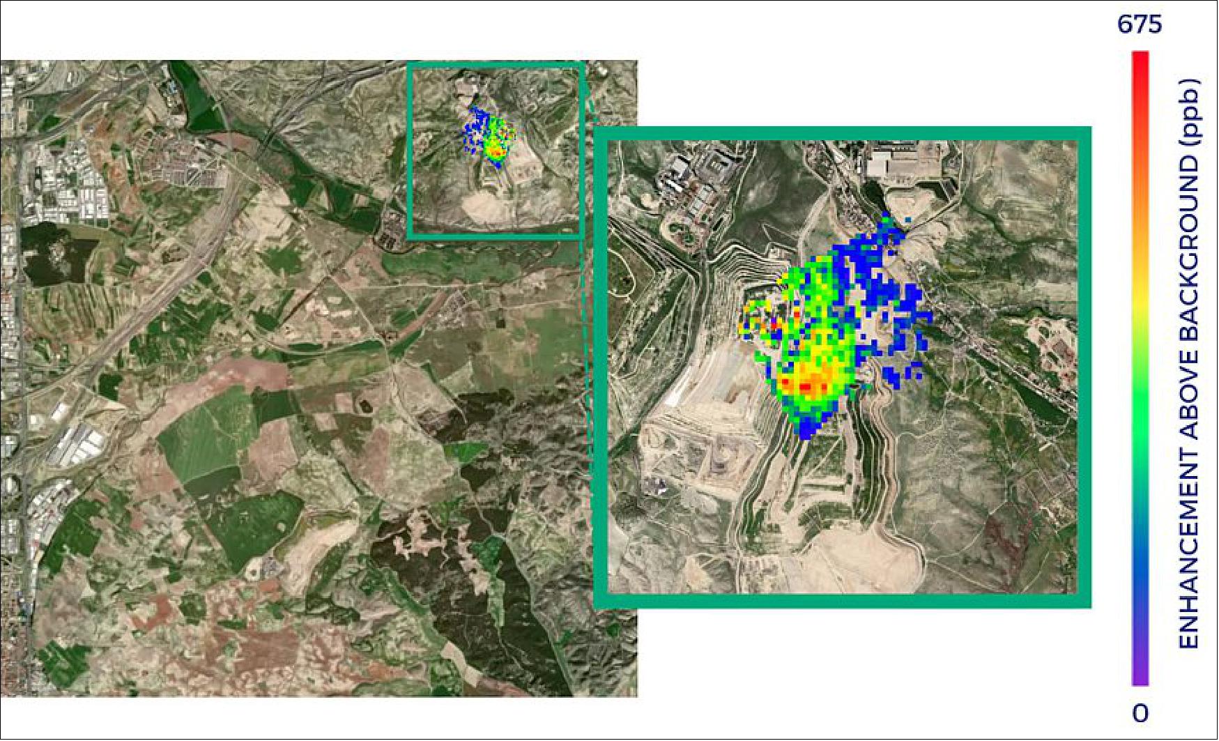
• November 10, 2021: GHGSat, in collaboration with SRON Netherlands Institute for Space Research, has detected significant methane emissions from landfill sites near Madrid, Spain, using data from Copernicus Sentinel-5P satellite and GHGSat's high-resolution commercial imagery. These observations revealed methane emissions of 8800 kg per hour in August 2021, the highest observed in Europe by GHGSat. The findings highlight the environmental impact of landfill emissions and underscore the importance of consistent monitoring to address methane's contribution to global warming. GHGSat's advanced satellite technology enables precise tracking of methane leaks, providing valuable data for environmental management and climate policy initiatives. 24)
• July 8, 2021: Royal Dutch Shell Plc, Chevron Corp., and TotalEnergies SE are collaborating on a satellite-based initiative to monitor methane emissions from offshore oil and gas platforms. Leveraging GHGSat Inc.'s infrared sensor technology, the project aims to accurately detect methane emissions, addressing a significant gap in emission tracking, particularly offshore where nearly 30% of global oil and gas production occurs. The initiative underscores the industry's commitment to reducing fugitive leaks, given methane's potent greenhouse effect. GHGSat's satellites will utilize precise measurement techniques, including acute angle observations and focusing on 'glint spots' on the sea surface to overcome challenges associated with offshore monitoring. TotalEnergies, among the participants, will complement satellite data with local drone-mounted spectrometer measurements, further enhancing methane detection capabilities. This collaborative effort signifies a step forward in methane emission monitoring technology development, reinforcing TotalEnergies' position as a leader in the field. 25)
• March 9, 2021: GHGSat has been recognized as one of Fast Company's World's Most Innovative Companies for 2021, topping the list of 463 businesses from 29 countries. The company's achievement highlights its impactful contributions to climate change mitigation through innovative satellite technology, particularly in detecting methane emissions with unprecedented precision. GHGSat's groundbreaking work in the field of "new space" and its commitment to combating climate change have earned it a prominent position in the global landscape of innovation. CEO Stéphane Germain attributes this recognition to the dedication of GHGSat's team towards their common goal of addressing climate change. 26)
• February 3, 2021: GHGSat-C2 "Hugo," the company's third satellite, achieved a significant milestone by capturing its first image of a methane plume within a week of its launch on January 24, 2021. Equipped with advanced sensors, Hugo can detect methane emissions from sources much smaller than some satellites and with significantly higher precision. This accomplishment underscores GHGSat's rapid progress in satellite-based emissions monitoring, with plans to expand its constellation to 10 satellites by the end of 2022, serving both commercial and governmental clients worldwide. CEO Stéphane Germain expressed pride in the satellite's swift methane observation, highlighting its exceptional speed and the company's commitment to emissions detection from space. 27)
• January 24, 2021: GHGSat achieved a significant milestone with the successful launch of its third satellite, GHGSat-C2 "Hugo," as part of a SpaceX Falcon 9 rideshare mission from Cape Canaveral Space Force Station on January 24, 2021. This collaboration with ABB Measurement & Analytics Canada marks GHGSat's first international technology partnership. Hugo joins the fleet of 10 high-resolution satellites set to be in orbit by 2022, each equipped with advanced sensors capable of detecting methane emissions from sources significantly smaller than previous satellites. The successful launch of Hugo, following the deployment of "Iris" in September 2020, doubles GHGSat's commercial capacity for precise emissions measurements. With three more satellites in production, GHGSat continues to advance its mission of providing crucial data for understanding and mitigating greenhouse gas emissions worldwide. 28)
• November 16, 2020: UTIAS/SFL has secured a contract from GHGSat to manufacture the next three microsatellites for its commercial greenhouse gas monitoring constellation, highlighting the demand for expanded data collection capacity. These satellites will enable GHGSat to provide emission reports and other products to a diverse clientele, including energy facilities and government agencies. GHGSat-C1, launched just two months prior, has already demonstrated remarkable performance in detecting small methane emissions, thanks to SFL's precise attitude control system. Leveraging insights from previous missions, SFL aims to further enhance the capabilities of GHGSat's constellation, emphasizing its commitment to advancing greenhouse gas monitoring from space. 6)
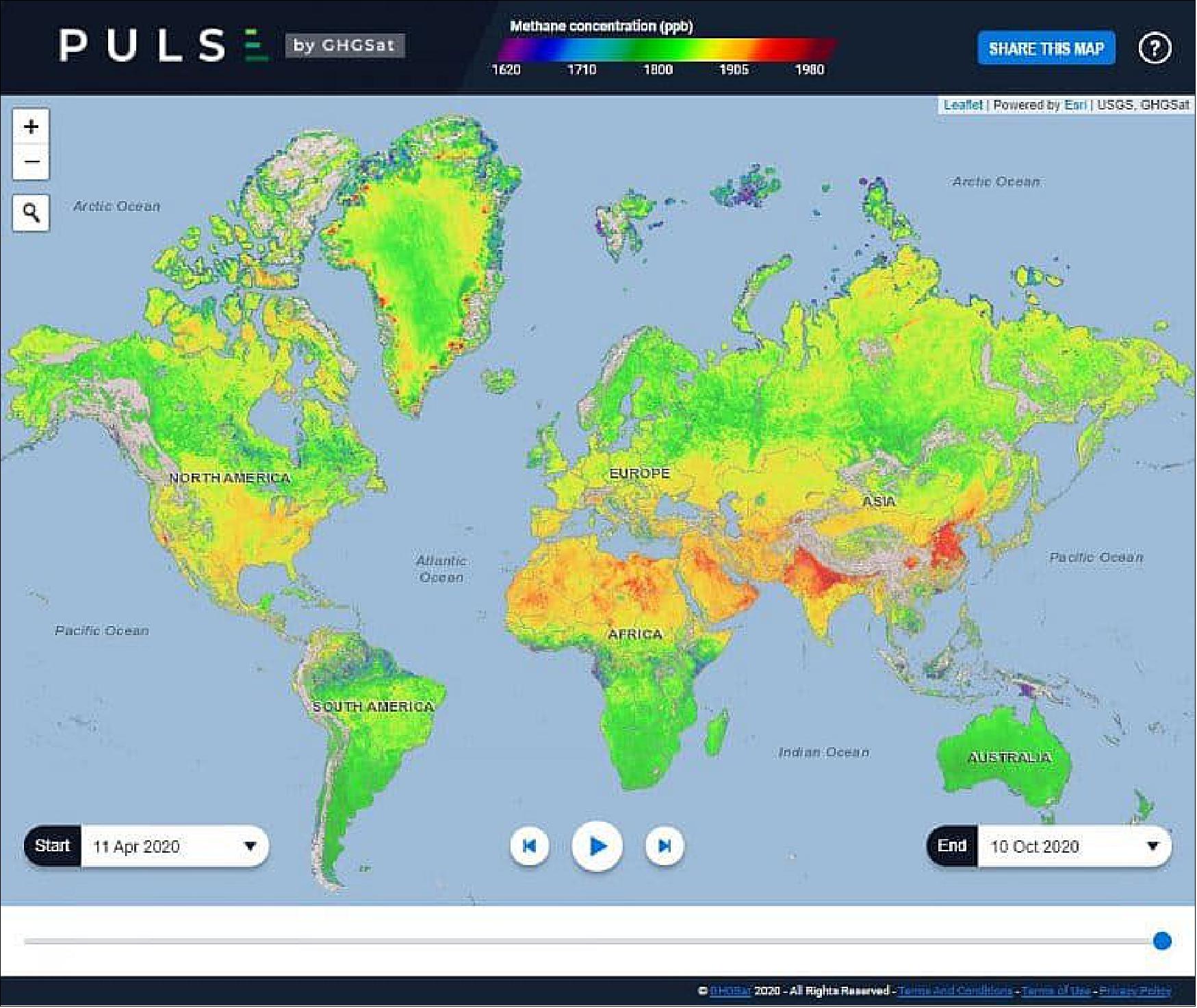
• October 21, 2020: GHGSat launches PULSE, a groundbreaking digital map showcasing global methane concentrations in Earth’s atmosphere, integrating data from its high-resolution satellites and other sources like the European Space Agency’s Sentinel-5P spacecraft. Updated weekly, PULSE offers monthly methane concentration averages on a 2 km x 2 km grid over land, enabling users to track changes over time and understand the impact of emissions and atmospheric transport processes. While not pinpointing specific emitters, PULSE aims to support industry and governments in emission reduction efforts, reflecting GHGSat's commitment to leveraging technology to combat climate change and offering data transparency through initiatives like data sharing with scientific communities and participation in the ESA Third Party Mission program. 29)
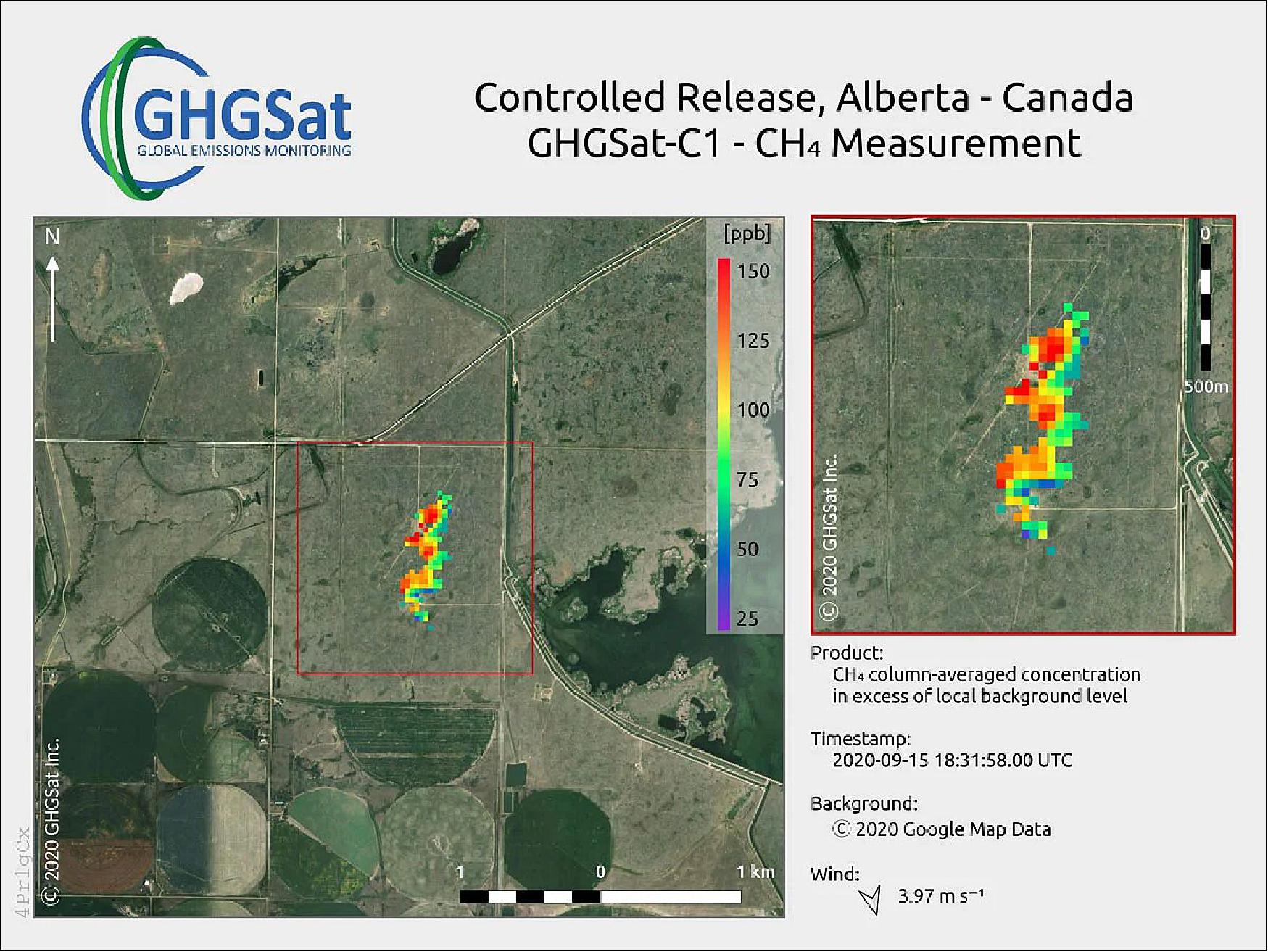
• October 8, 2020: GHGSat's latest satellite, GHGSat-C1 ("Iris"), surpasses its predecessor's performance by fivefold, detecting methane emissions from a controlled release in Alberta, Canada, within two weeks of launch. The satellite's advanced sensor technology promises tenfold improvement over previous capabilities, setting a new standard for methane monitoring from space. 30)
• October 6, 2020: GHGSat has partnered with ABB to provide payloads for its next three methane-detecting satellites, marking a significant step towards its goal of deploying a constellation of 10 spacecraft by 2022. GHGSat's satellites, capable of high-resolution greenhouse gas detection, offer unparalleled leak monitoring, particularly for methane emissions from individual facilities. The collaboration aims to enhance monitoring capabilities crucial for sectors like oil and gas, waste management, and agriculture, enabling timely action to mitigate emissions. 7)
Sensor Complement
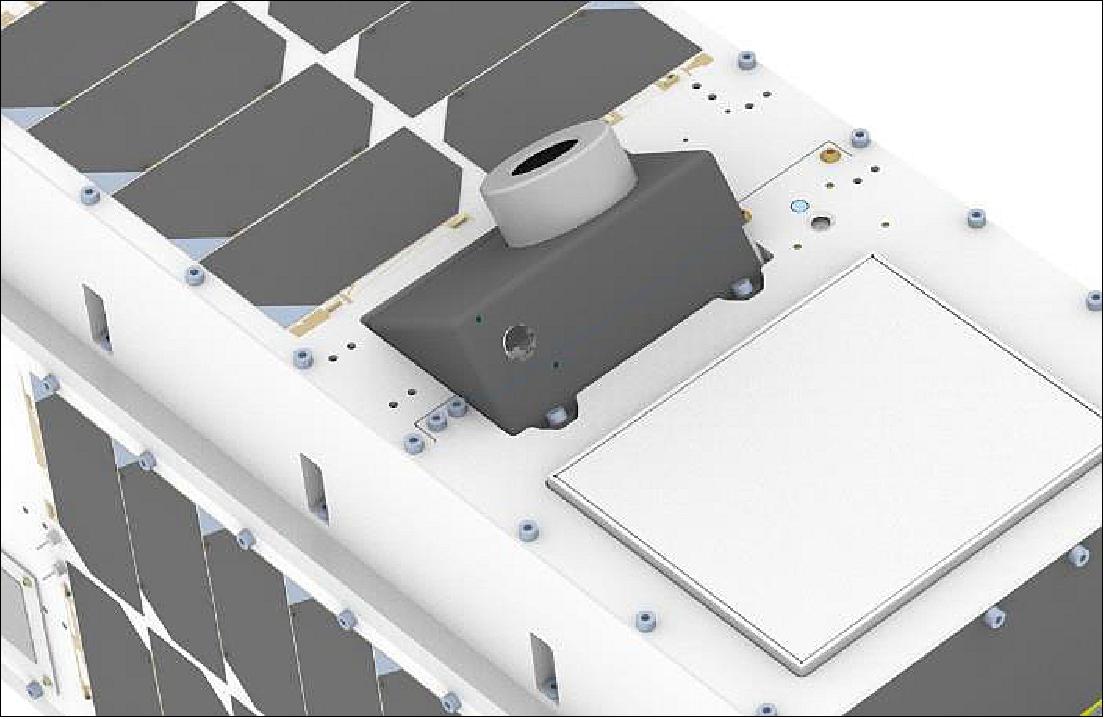
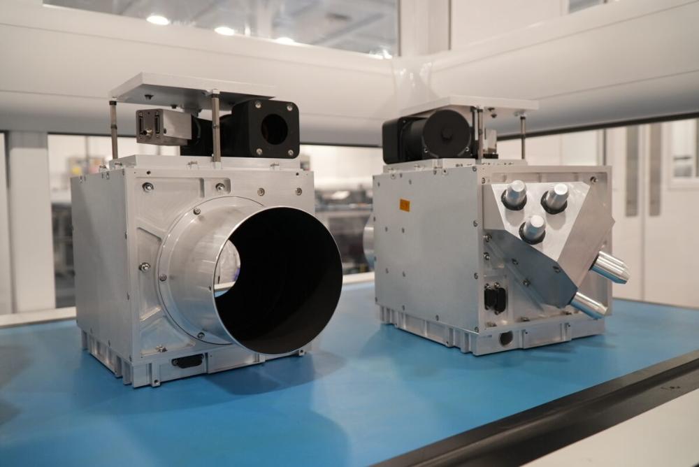
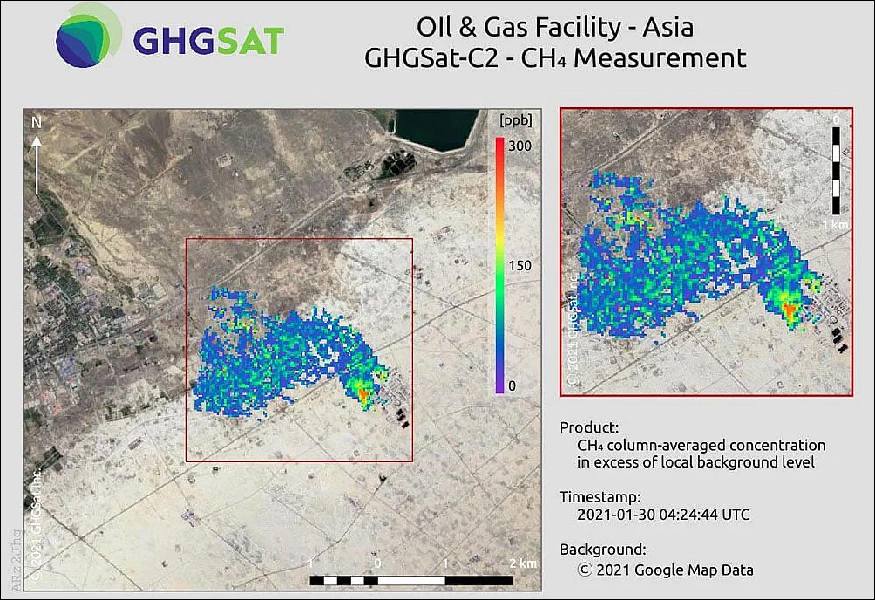
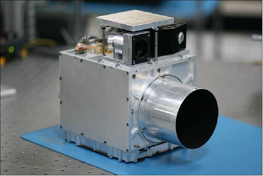
WAF-P (Wide-Angle Fabry-Perot) Imaging Spectrometer
The Imaging Spectrometer, operating in the SWIR (Short-Wave Infrared) region, is based on a Fabry-Perot (FP) interferometer. The optical design of the instrument includes three lens groups, in addition to the Fabry-Perot interferometer, as well as beam folding mirrors required to fit the telescope within a microsatellite bus. The payload avionics includes a Q7 hybrid processor provided by Xiphos Systems Corporation.
GHGSat-D flew the first iteration of this payload, shown in Figure 17. Each target observation produces approximately 200,000 measurements of the atmospheric radiance in the SWIR region.
Several changes were made to the payload for GHGSat-C1/-C2 to improve upon the performance of GHGSat-D. These include upgrades to further mitigate stray light, ghosting, spectral bandpass inefficiencies, and radiation effects.
Stray light is extra light observed by the optical payload which was not intended to be observed. During nominal satellite operations, it was determined that up to 5% stray light was encountered on GHGSat-D with much of that being from off-axis incoming light. To improve upon this, several elements of the optical system were redesigned.
Ghosting is rotated, reflected, zoomed, or translated copies of the intended image. To improve upon this, anti-reflective (AR) coatings were either updated or newly applied to various surfaces in the optical system.
The GHGSat-D payload restricted the incident spectral passband to a wavelength region between 1600-1700 nm, which was selected for the presence of spectral features of methane and carbon dioxide, as well as relatively little interference from other atmospheric species. However, attempting to capture both methane and carbon dioxide lines proved to be inefficient. Therefore, the passband was narrowed in order to focus on methane.
Radiation in the space environment affected the detector. To help increase the lifetime of the detector radiation shielding was introduced around the IR camera for GHGSat-C1/-C2.
- The WAF-P measures vertical column densities of CO2 and CH4.
- The WAF-P spectral range is in the short-wave infrared (SWIR) at 1600-1700 nm, with multiple bands in a proprietary configuration.
C&A (Clouds & Aerosol) Camera
GHGSat-D also had a cloud and aerosol camera secondary payload, which ultimately did not contribute significantly to the mission. Therefore it was replaced with a visible light auxiliary camera, providing higher resolution imagery to improve image alignment and georeferencing.
The C&A measures interference from clouds and aerosols in the field of view of the WAF-P.
- The C&A spectral range is in the visible and near-infrared (VNIR) at 400-1000 nm, with 325 bands at 1.9 nm spectral resolution.
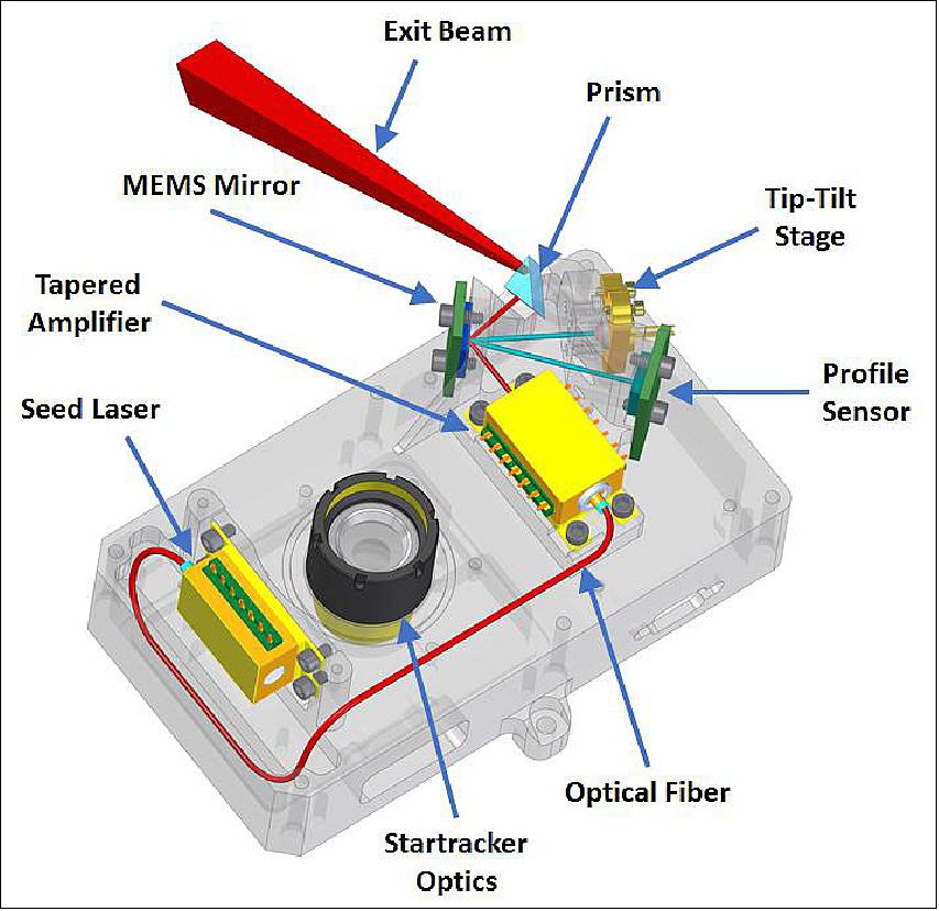
Darkstar (Experimental Optical Downlink)
The downlink is currently the system bottleneck, given that the payload can generate data faster than it can be downlinked to the ground. GHGSat-D, along with GHGSat-C1/-C2, have an S-band transmitter for downlinking payload data and satellite bus telemetry. This system can achieve downlink rates of up to 2 Mbit/s. GHGSat-C1/-C2 are therefore testing an experimental laser downlink system that is intended to achieve downlink rates of up to 1 Gbit/s. Designed by Sinclair Interplanetary, the wavelength of the laser is785 nm, in the near-IR range.
The optical downlink is built on the reverse side of the optical bench of an expanded Sinclair Interplanetary ST-16RT2 star tracker, shown in Figure 18. Its mass is less than 400 g and its outer dimensions are 100 x 68 x 68 mm.
Darkstar interfaces with a Q8 processor designed by Xiphos Systems Corporation. The Q8 processor is a new design and is also included on GHGSat-C1 in order to gain flight heritage. The Q8 is connected to the payload avionics via an Ethernet connection for high speed data transfer. Although the primary means of downlinking payload data will still be over the S-band transmitter, the connection between the Q8 and the payload avionics exists in order to test and characterize the optical downlink system with the large volume of data generated by the main payload.
References
1) Laura M. Bradbury, Michael Ligori, Robert Spina, Daniel Kekez, Pawel Lukaszynski, Robert E. Zee, Stephane Germain, ”On-Orbit Greenhouse Gas Detection with the GHGSat Constellation,” Proceedings of the 69th IAC (International Astronautical Congress) Bremen, Germany, 1-5 October 2018, paper: IAC-18.B4.4.8
2) Stephane Germain, Berke Durak, Jason McKeever, Vincent Latendresse, Cordell Grant, James J. Sloan, ”Global Monitoring of Greenhouse Gas Emissions,” Proceedings of the 30th Annual AIAA/USU SmallSat Conference, Logan UT, USA, August 6-11, 2016, paper: SSC16-III-11, URL: https://digitalcommons.usu.edu/cgi/viewcontent.cgi?article=3355&context=smallsat
3) ”Canada's 7th National Communication and 3rd Biennial Report,” Gatineau, QC: Environment and Climate Change Canada, 2017, URL: https://unfccc.int/files/national_reports/national_communications_and_biennial_reports/application/pdf/82051493_canada-nc7-br3-1-5108_eccc_can7thncomm3rdbi-report_en_04_web.pdf
4) Jeff Foust, ”GHGSat to launch three spacecraft on Falcon 9,” SpaceNews, 8 December 2021, URL: https://spacenews.com/ghgsat-to-launch-three-spacecraft-on-falcon-9/
5) ”GHGSat confirms launch of its next three satellites with SpaceX,” GHGSat Press Release, 8 December 2021, URL: https://www.ghgsat.com/en/newsroom/ghgsat-confirms-launch-of-its-next-three-satellites-with-spacex/
6) ”Space Flight Laboratory (SFL) Awarded Contract by GHGSat Inc. to Build Three More Greenhouse Gas Monitoring Microsatellites,” UTIAS/SFL, 16 November 2020, URL: https://www.utias-sfl.net/?p=3466
7) ”GHGSat Signs with ABB to Deliver Payloads for Growing Constellation,” GHGSat Press Release, 6 October 2020, URL: https://www.ghgsat.com/ghgsat-signs-with-abb-to-deliver-payloads-for-growing-constellation/
8) ”GHGSat-C1/C2,” GHGSat, January 2017, URL: http://www.ghgsat.com/who-we-are/our-satellites/satellite-2/
9) ”Space Flight Laboratory (SFL) to Develop Microsatellites for Greenhouse Gas Monitoring,” UTIAS/SFL, 24 March 2017, URL: https://web.archive.org/web/20221002230707/https://www.utias-sfl.net/?p=2541
10) ”Greenhouse Gas Monitoring from Space: GHGSat Launches Three New Satellites with SpaceX,” GHGSat, Press Release, 25 May 2022, URL: https://www.ghgsat.com/en/newsroom/greenhouse-gas-monitoring-from-space-ghgsat-launches-three-new-satellites-with-spacex/
11) Jeff Foust, ”SpaceX launches record-setting cluster of smallsats,” SpaceNews, 24 January 2021, URL: https://spacenews.com/spacex-launches-record-setting-cluster-of-smallsats/
12) Jeff Foust, ”FCC grants permission for polar launch of Starlink satellites,” SpaceNews, 9 January 2021, URL: https://spacenews.com/fcc-grants-permission-for-polar-launch-of-starlink-satellites/
13) ”Vega return to flight proves new rideshare service,” ESA Enabling & Support, 3 September 2020, URL: https://www.esa.int/Enabling_Support/Space_Transportation/Vega/Vega_return_to_flight_proves_new_rideshare_service
14) ”GHGSat's Second Satellite Named and to Launch in August,” Satnews Daily, 4 April 2019, URL: http://www.satnews.com/story.php?number=812237862
15) ”With Vega, Arianespace successfully performs the first European mission to launch multiple small satellites,” Arianespace Press Release, 3 September 2020, URL: https://www.arianespace.com/press-release/with-vega-arianespace-successfully-performs-the-first-european-mission-to-launch-multiple-small-satellites/
16) ”Vega flight VV16,” Wikipedia, URL: https://en.wikipedia.org/wiki/Vega_flight_VV16
17) Mike Safyan, ”Planet’s First Launch of 2020: 26 SuperDoves on a Vega,” Planet, 13 February 2020, URL: https://www.planet.com/pulse/planets-first-launch-of-2020-26-superdoves-on-a-vega/
18) ”Russian mine produces biggest methane leak ever seen by GHGSat,” GHGSat Press Release, 15 June 2022, URL: https://www.ghgsat.com/en/newsroom/russian-mine-produces-biggest-methane-leak-ever-seen-by-ghgsat/
19) Methane emission equivalencies: https://www.epa.gov/energy/greenhouse-gas-equivalencies-calculator
20) Raspadskya Mine Explosion: https://en.wikipedia.org/wiki/Raspadskaya_mine_explosion
21) Turkmenistan event: https://www.forbes.com/sites/scottcarpenter/2019/11/27/detection-of-methane-leak-from-space-could-herald-a-revolution/?sh=4c506f43667c
22) ”GHGSat joins ESA’s Third Party Mission Programme,” ESA Applications, 24 May 2022, URL: https://www.esa.int/Applications/Observing_the_Earth/GHGSat_joins_ESA_s_Third_Party_Mission_Programme
23) ”Cow burps seen from space,” GHGSat Press Release, 2 May 2022, URL: https://www.ghgsat.com/en/newsroom/cow-burps-seen-from-space/
24) ”Satellites detect large methane emissions from Madrid landfills,” ESA Applications, 10 November 2021, URL: https://www.esa.int/Applications/Observing_the_Earth/Satellites_detect_large_methane_emissions_from_Madrid_landfills
25) Aaron Clark, ”Shell, TotalEnergies Join Satellite Effort to Track Methane,” Bloomberg News, 8 July 2021, URL: https://www.bnnbloomberg.ca/shell-totalenergies-join-satellite-effort-to-track-methane-1.1626585
26) ”Montreal-based emissions monitoring company among top-ranked in the Space category,” GHGSat Press Release, 9 March 2021, URL: https://www.ghgsat.com/fast-company-names-ghgsat-to-its-annual-list-of-the-worlds-most-innovative-companies-for-2021/
27) ”Hugo delivers first methane plume image,” GHGSat Press Release, 3 February 2021, URL: https://www.ghgsat.com/hugo-delivers-first-methane-plume-image/
28) ”GHGSat Satellite ''Hugo'' - Rideshare Launch with SpaceX a Success,” PR Newswire, 24 January 2021, URL: https://www.prnewswire.com/news-releases/ghgsat-satellite-hugo---rideshare-launch-with-spacex-a-success-301213612.html
29) ”GHGSat launches PULSE – a free and unique high-resolution methane map,” GHGSat Press Release, 21 October 2020, URL: https://www.ghgsat.com/ghgsat-launches-pulse/
30) ”Smallest Methane Emission Ever Detected by Satellite,” GHGSat Press Release, 8 October 2020, URL: https://www.ghgsat.com/smallest-methane-emission-ever-detected-by-satellite/
31) Doug Sinclair, Kathleen Riesing, ”The Rainbow Connection -Why Now is the Time for SmallSat Optical Downlinks,” Proceedings of the 31st Annual AIAA/USU Conference on Small Satellites, Logan UT, USA, Aug. 5-10, 2017, paper: SSC17-II-06, URL: https://digitalcommons.usu.edu/cgi/viewcontent.cgi?article=3605&context=smallsat
32) Space Flight Laboratory, "Space Flight Laboratory (SFL) Announces Launch of Nine Satellites Supporting Four Microspace Missions", April 16, 2023, URL: https://lidarmag.com/2023/04/16/space-flight-laboratory-sfl-announces-launch-of-nine-satellites-supporting-four-microspace-missions/
33) GHGSat, "Space Flight Laboratory (SFL) Announces Launch of Nine Satellites Supporting Four Microspace Missions", April 21, 2023, URL: https://www.ghgsat.com/en/newsroom/three-new-methane-monitoring-satellites-make-contact-in-record-time/
34) NewsWire, "New Satellites to Accelerate the Fight Against Climate Change Launched Into Orbit With SpaceX", April 15, 2023, URL: https://www.ghgsat.com/en/newsroom/three-new-methane-monitoring-satellites-make-contact-in-record-time/
35) SatNews, "GHGSat to launch 6 high-resolution emission monitoring satellites in 2023", February 27,, 2023, URL: https://news.satnews.com/2023/02/27/ghgsat-to-launch-6-high-resolution-emission-monitoring-satellites-in-2023/#:~:text=GHGSat%20will%20be%20launching%20six,SpaceX's%20Transporter%2D7%20rideshare%20mission
36) Rainbow, Jason, “GHGSat orders four more greenhouse gas monitoring cubesats from Spire”, Space News, August 8, 2023, URL: https://spacenews.com/ghgsat-orders-four-more-greenhouse-gas-monitoring-cubesats-from-spire/
37) GHGSat, “World’s First Commercial CO2 Sensor in Orbit”, November 11, 2023, URL: https://www.ghgsat.com/en/newsroom/worlds-first-commercial-co2-sensor-in-orbit/
38) Lentz, Denny, “SpaceX Transporter 9 rideshare features new OTV from Tom Mueller’s Impulse Space”, Nasa Space Flight, November 11, 2023, URL: https://www.nasaspaceflight.com/2023/11/transporter-9/
39) OSCAR, “Satellite: GHGSat”, URL: https://space.oscar.wmo.int/satellites/view/ghgsat
40) GHGSat, “GHGSat signs strategic partnership with Yahsat and ADNOC supporting the mitigation of global energy sector’s methane emissions”, December 6, 2023, URL: https://www.ghgsat.com/en/newsroom/ghgsat-signs-strategic-partnership-with-yahsat-and-adnoc-supporting-the-mitigation-of-global-energy-sectors-methane-emissions/
Spacecraft Launch Mission Status Sensor Complement References Back to top