GOSAT-2 (Greenhouse gases Observing Satellite-2) / Ibuki-2
EO
JAXA
Atmosphere
Cloud type, amount and cloud top temperature
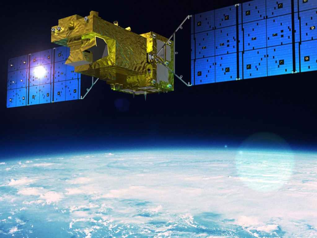
Launched in October 2018 from Tanegashima Space Centre in Japan, the Greenhouse Gases Observing Satellite-2 (GOSAT-2), a joint project of the Japan Aerospace Exploration Agency (JAXA), the Ministry of the Environment (MOES) and the National Institute for Environmental Studies (NIES), is a successor mission of Greenhouse Gases Observing Satellite (GOSAT). GOSAT-2, also known as Ibuki-2, is an Earth observation mission dedicated to greenhouse gas monitoring, observing carbon dioxide, methane, ozone, carbon monoxide, nitrogen dioxide and water vapour in the atmosphere.
Quick facts
Overview
| Mission type | EO |
| Agency | JAXA, MOE (Japan), NIES (Japan) |
| Mission status | Operational (extended) |
| Launch date | 29 Oct 2018 |
| Measurement domain | Atmosphere, Land |
| Measurement category | Cloud type, amount and cloud top temperature, Atmospheric Temperature Fields, Aerosols, Vegetation, Ozone, Trace gases (excluding ozone) |
| Measurement detailed | Atmospheric pressure (over sea surface), Cloud cover, Aerosol optical depth (column/profile), O3 Mole Fraction, CH4 Mole Fraction, Normalized Differential Vegetation Index (NDVI), CO2 Mole Fraction, CO Mole Fraction, Atmospheric pressure (over land surface), HDO (column/profile), Chlorophyll Fluorescence from Vegetation on Land |
| Instruments | TANSO-CAI-2, TANSO-FTS-2 |
| Instrument type | Imaging multi-spectral radiometers (vis/IR), Atmospheric chemistry |
| CEOS EO Handbook | See GOSAT-2 (Greenhouse gases Observing Satellite-2) / Ibuki-2 summary |
Related Resources
Mission Summary
Mission Capabilities
GOSAT-2 carries two Thermal and Near-infrared Sensors for Carbon Observation (TANSO), the Fourier Transform Spectrometer-2 (TANSO-FTS-2) and the Cloud, and Aerosol Imager-2 (TANSO-CAI-2). TANSO-FTS-2 measures the density of greenhouse gases in the atmosphere and can detect the precise location of greenhouse gas emissions with high accuracy over the entire globe and with rapid uptake rates.
TANSO-CAI-2 is a push-broom imaging sensor that observes the optical properties of aerosols and clouds, and monitors the status of urban and ocean trans-boundary air pollution.
Performance Specifications
TANSO-FTS-2 has five spectral bands with spectral ranges ranging from 0.755 - 14.29 µm, and cross- and along-track coverage of ±35° and ±40° respectively. TANSO-CAI-2 has five spectral bands with spectral ranges from 0.333 - 1.675 µm, spatial resolution ranging from 460 - 920 m at nadir, and a swath of 1000 km.
GOSAT-2 is in a sun-synchronous orbit, at an altitude of 613 km and an inclination of 97.84°. The Local Time on Descending Node (LTAN) is at 1300 ± 0015 hours, and the repeat cycle is 6 days.
Space and Hardware Components
GOSAT-2 is built by Mitsubishi Electric Corporation (MELCO) in Japan. It is a medium-sized satellite with two solar paddles, a mass of about 1700 kg, a power generation of 5kW and five-year design life.
GOSAT-2 (Greenhouse gases Observing Satellite-2) / Ibuki-2
Spacecraft Sensor Complement References
GOSAT-2 is a follow-on Japanese mission in planning of GOSAT/Ibuki which was launched on January 23, 2009. The experiences gained from the operation of the GOSAT mission with regard to payload calibration and validation activities serve as input for the requirements of the GOSAT-2 mission. 1)
Although TANSO-FTS (on GOSAT) has some anomalies, GOSAT has accomplished certain results; in particular, the project recognized the availability of the GHG (Greenhouse Gas) observation from space and at the same time it has been pointed out that it's necessary to improve the concentration measurement precision to expand this mission to make it useful for humankind.
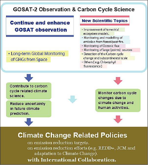
Hence, Japan's three parties, MOE (Ministry of the Environment), NIES (National Institute for Environmental Studies) and JAXA (Japan Aerospace Exploration Agency), which have led the GOSAT project, have investigated the requirements on the future greenhouse gases observation and defined the mission requirements for the GOSAT-2 mission. The overall mission goal is to give policy makers further observed and analyzed data on climate changes to contribute to decisions on emission reduction targets based on scientific facts. 2) 3)
Mission requirements | GOSAT | GOSAT-2 |
Uncertainty reduction of the future forecast | ||
1. Concentration measurement precision | 4 ppm (CO2) | 0.5 ppm (CO2) |
2. Estimation accuracy of flux | Reduce the estimation error on the sub-continental scale to half compared with the one estimated using only ground observation data | Estimate the monthly net fluxes with the accuracy of ±100%. Use of 1,000 km mesh (terrestrial region) and 4,000 km mesh (ocean) |
Monitoring of greenhouse gas emissions | ||
3. Expansion of the observation gases | - | Examine the feasibility of the calculation of the anthropogenic emission with the observation of the correlated material such as CO and NO2 |
4. Improvement of the natural emission estimation accuracy | (Chlorophyll Fluorescence observation as a result) | Investigate the correlation between the distribution of greenhouse gases and the vegetation activity |
Some background: Experts say that greenhouse gases produced by human activity represent one of the biggest causes of global warming. The IPCC ( Intergovernmental Panel on Climate Change), an international organization of specialists that conducts scientific research on climate change and evaluates related climate policies, released its Fifth Assessment Report in 2013. In the document, the authors warned that "Warming of the climate system is unequivocal... It is extremely likely that human influence has been the dominant cause of the observed warming since the mid-20th century... Continued emissions of greenhouse gases will cause further warming and changes in all components of the climate system." 4)
As the successor to the Ibuki mission, GOSAT-2 aims to gather observations of greenhouse gases with higher levels of accuracy via even higher-performance onboard observation sensors. The project will serve to provide observation data to environmental administrations and drive international anti-global warming efforts.
In December 2013, JAXA selected MELCO (Mitsubishi Electric Corporation) to build the GOSAT-2 spacecraft which is slated for launch in 2018. Mitsubishi Electric expects to be formally authorized to proceed with the development in April 2014, after completing an engineering contract with JAXA to finalize definitive performance requirements. 5) — In April 2014, JAXA awarded the GOSAT-2 contract to Mitsubishi Electric to officially begin developing the satellite system. 6)
GOSAT-2, like GOSAT/Ibuki, is a joint project of MOE, NIES and JAXA. Its high-performance sensor instrumentation will enable the collection of even more accurate data than was possible with Ibuki. 7)
In May 2014, ITT Exelis of Rochester, N.Y. (now Harris Corp. with HQ in Melbourne FL USA), has been awarded a contract to build TANSO-FTS (Thermal and Near-Infrared Sensor for carbon Observation-Fourier Transform Spectrometer), the primary payload for GOSAT-2. 8)
The goals for the GOSAT-2 are to measure carbon dioxide at 0.5 ppm and methane at 5 ppb at a 500 km mesh. Developers have also enhanced the satellite's focused, target-point observation capabilities (target-point observation functionality), enabling the device to gather accurate readings from a broader range of target points - an ability that will be especially beneficial in evaluations of industrial areas, densely populated areas, and other areas with large quantities of greenhouse gas emissions.
In another improvement over its predecessor, the GOSAT-2 is also capable of monitoring carbon monoxide concentrations. Whereas carbon dioxide not only comes from anthropogenic sources like industrial activity and fuel combustion but also has natural origins in forests and biological activity, carbon monoxide emissions are byproducts of human activity alone – not the natural world. Analyzing combined observations of carbon dioxide and carbon monoxide will give researchers an effective means of estimating carbon dioxide emissions from anthropogenic sources.
Item | GOSAT-2 | GOSAT |
Observed greenhouse gases | CO2, CH4, O3, H2O, CO, NO2 | CO2, CH4, O3, H2O |
Instruments | 1. FTS (Fourier Transform Spectrometer) | 1. FTS |
LTAN (Local Time on Ascending Node) | 13:00 ± 0:15 hr | 13:00 ± 0:15 hr |
Orbital altitude | 613 km | 666 km |
Revisit time | 3 days (may be increased) | 3 days |
TANSO-FTS (Thermal And Near infrared Sensor for carbon Observation - Fourier Transform Spectrometer) | ||
Coverage | Cross-track: ±35º, Along-track: ±40º | Cross-track: ±35º, Along-track: ±20º |
Sampling | About 160 km interval, (5 points in the CT) | About 160 km interval |
IFOV | 10.5 km | 10.5 km |
Spectral ranges | 1) 0.75-0.77 µm, 12,900-13,200 cm-1 (P/S) (O2A) | 1) 0.75-0.77 µm, 12,900-13,200 cm-1 (O2A) |
Sampling duration | 4 s | 4 s |
Function | Intelligent pointing | - |
Spectral resolution | 0.2 cm-1 | 0.2 cm-1 |
SNR | >400 (Band 1) | >300 |
TANSO-CAI (Thermal And Near infrared Sensor for carbon Observation - Cloud and Aerosol Imager) | ||
Spectroscopic System | Band pass filter and grating | Band pass filter |
Spectral ranges | 1) 322-450 nm (1 nm step) 4) to be eliminated | 1) 370-390 nm |
Spatial resolution, swath | 1 km, 1000 km | Band 1-3: 500 m, 1000 km |
Spacecraft
The spacecraft is being manufactured by MELCO (Mitsubishi Electric Corporation), Kamakura Works, Japan as the prime contractor of GOSAT-2. JAXA awarded a preliminary contract to MELCO in December 2013 and a final contract in April 2014. In addition to building the GOSAT-2 spacecraft, a role MELCO performed for the first GOSAT, the company will manage development of the GOSAT-2 sensors and ground system as well as provide operation and maintenance services throughout the orbital design life of GOSAT-2, helping to ensure reliable, high-quality data.
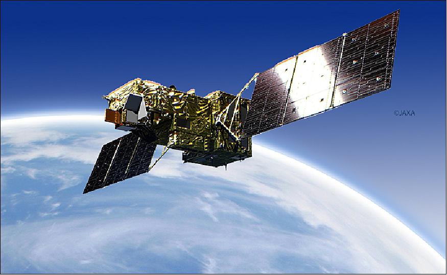
The GOSAT-2 spacecraft is a medium-size satellite with two solar paddles. Its design is based on JAXA's ALOS-2 satellite launched in 2014. GOSAT-2 has a mass of about 1700 kg (dry mass), provides a power generation of 5 kW and has a design life of 5 years.
Parameter/Item | GOSAT-2 | GOSAT |
Orbit type | Sun synchronous | Sun synchronous |
Local equator crossing time in a descending node | 13:00 ± 0:15 hour | 13:00 ± 0:15 hour |
Altitude | 613 km | 666 km |
Repeat cycle | 6 days | 3 days |
Spacecraft size (main body) | 5.3 x 2.0 x 2.8 m | 3.7 x 1.8 x 2.0 m |
Spacecraft mass | < 2,000 kg | 1,750 kg |
Spacecraft power | 5.0 kW | 3.8 kW |
Launch
The GOSAT-2/Ibuki-2 satellite was launched on 29 October 2018 (04:08:00 UTC, 13:08:00 JST) on the H-IIA vehicle. The launch site was TNSC (Tanegashima Space Center), Kagoshima, Japan. — The launch and flight of H-IIA F40 proceeded as planned. The separations of GOSAT-2 and KhalifaSat were confirmed respectively at approximately 16 minutes and 09 seconds and 24 minutes and 15 seconds after liftoff. 11) 12)
Orbit: Sun-synchronous orbit, altitude = 613 km, inclination = 97.8º, revisit cycle of 6 days, LTAN (Local Time at Ascending Node) at 13:00 ± 0.15 hours.
Secondary Payloads on Launch Vehicle
• KhalifaSat, an Earth Observation minisatellite of MBRSC (Mohammed Bin Rashid Space Center), Dubai.
• Diwata-2b, a Philippine EO microsatellite, developed at the Philippine DOST (Department of Science and Technology) in cooperation with the Tohoku University and Hokkaido University, Japan.
• PROITERES-2 (Project of Osaka Institute of Technology Electric-Rocket-Engine onboard Small Space Ship-2), a technology demonstration microsatellite (50 kg) of OIT (Osaka Institute of Technology), Japan.
• AUTcube-2, a CubeSat technology demonstration of Aichi University of Technology, Japan.
• Stars-O, a CubeSat technology demonstration of Shizuoka University, Japan.
• Ten-Koh is a technology demonstration minisatellite (220 kg) of the Kyushu Institute of Technology, Japan. The satellite is to observe LEO environments (magnetosphere observation) and the primary purpose is to provide valuable data for future development of satellites or operation.
Mission Status
• July 5, 2019: In this NIES (National Institute for Environmental Studies) Press Release, the project summarized the analysis results of the proxy-method based retrievals (methane and carbon monoxide) from data acquired by the Thermal And Near infrared. Sensor for carbon Observation - Fourier Transform Spectrometer-2 (TANSO-FTS-2) on board GOSAT-2. 13)
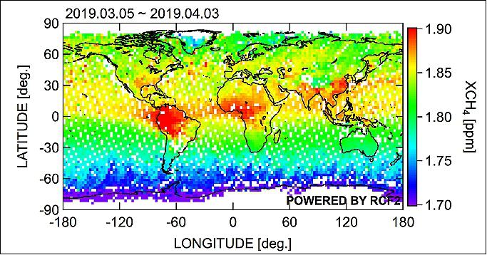
- Figure 3 is the global distribution of methane column-averaged dry-air mole fraction (XCH4) retrieved from data acquired by FTS-2 from 5 March to 3 April 2019. This time, the proxy method was applied to FTS-2 Level 1B product (V002.004) to retrieve XCH4. The figure depicts the higher CH4 concentration in Southeast and South Asia, Central Africa and in the northern part of South America, in which many wetlands and forest fires, large sources of methane emissions, have been seen.
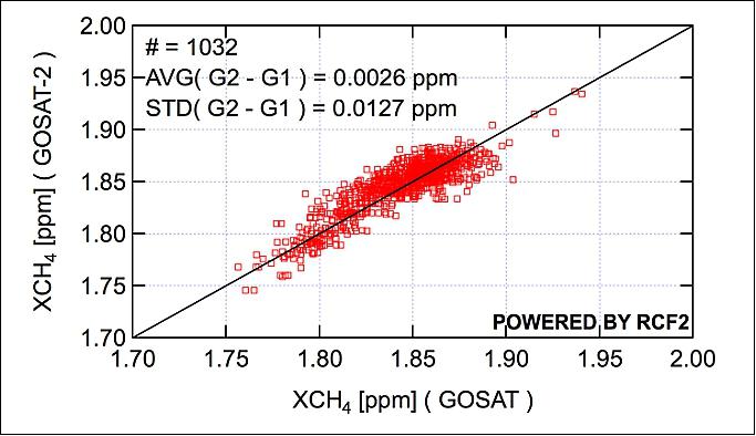
- Figure 4 is the comparison of GOSAT-2 XCH4 (Proxy Method) with GOSAT XCH4 (Full Physics Method) for the same period. The mean difference in XCH4 between GOSAT and GOSAT-2 is found to be 0.0026 ppm (2.6 ppb) and the standard deviation (SD) is 0.0127 ppm (12.7 ppb). The precision of GOSAT XCH4 has already been verified by comparing with ground-based data, where the mean difference is 0.0019ppm (1.9 ppb) and the SD is 0.0134 ppm (13.4 ppb). Given that these values are almost the same compared to GOSAT-2 XCH4, GOSAT-2 XCH4 retrievals are considered reasonable.
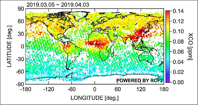
- Likewise, Figure 5 is the global distribution of carbon monoxide column-averaged dry-air mole fraction (XCO) retrieved by the proxy method from FTS-2 data, showing that XCO concentration is higher in South Asia and Central Africa where CO emissions from sources including fossil fuel use and forest fire are high. The similar distribution has also been seen in data derived for the same period by the TROPOMI (Tropospheric Monitoring Instrument) on board Sentinel-5p, one of the European Earth observation satellites. In addition, the estimated concentration values are confirmed to be mostly consistent with ground-based data acquired at several observation sites in the world. On another note, CO is one of the GOSAT-2's newly adopted measuring items, which is expected to be used to identify greenhouse gas emission sources. It should also be noted that CAI-2 data including cloud discrimination products are not yet utilized at this time, and FTS-2 data which were acquired in the presence of clouds may be included in the retrieval results presented here.
- The project will further work on estimating column-averaged dry-air mole fraction of CO2 using the full-physics method while proceeding validation of acquired concentration data by comparing with ground-based observational data as well as data acquired by similar satellites from Europe and the U.S. GOSAT-2 Level 2 products including the concentration data mentioned above are scheduled to be publicly released in one year from the launch of GOSAT-2, that is after the end of October, 2019.
• On 1 February 2019, GOSAT-2 shifted its operation mode to nominal and started global observations by CAI-2 and FTS-2 (Ref. 13).
• On 5-6 November 2018, GOSAT-2 collected the first light data from the onboard instrument TANSO-CAI-2; and on 12-14 December 2018, data from the TANSO-FTS-2 were acquired, confirming that the onboard instruments were operating nominally (Ref. 13).
• October 30, 2018: JAXA received telemetry data from Ibuki-2 (GOSAT-2), confirming that the satellite attitude control system had transitioned to a steady state. The current status of the Ibuki-2 satellite is stable. 14)
- Subsequently, the following procedure occurred : power generation that supports the satellites' operation by the deployed solar array wings, ground communications and sound attitude control that maintains those operations. Combined by the completion of the series of other operations, such as powering up of the bus and mission equipment, Ibuki-2 has been able to sustain itself in orbit. This concludes the critical operations phase.
- Ibuki-2 will move on to the next operations phase, where the functions of the satellite's onboard apparatus will be examined approximately in the next 2.5-month period.
• June 13, 2018: The Harris-built TANSO-FTS-2 instrument was delivered to Mitsubishi Electric Corporation for their GOSAT-2 Satellite, which is building the satellite for JAXA (Japanese Aerospace Exploration Agency). 10)
- This represents the third instrument Harris has delivered to Japan in recent years, including two advanced imagers for the Himawari-8 and -9 weather satellites, which launched in 2014 and 2016, respectively.
Sensor Complement
TANSO-FTS-2 (Thermal and Near-infrared Sensor for Carbon Observation-Fourier Transform Spectrometer-2)
In May 2014, MELCO awarded a subcontract to ITT Exelis of Rochester, N.Y. (now Harris Corp. of Melbourne FL, USA) to build TANSO-FTS-2, the primary instrument for GOSAT-2 (Ref. 8). The objective of TANSO-FTS-2 is to measure the density of greenhouse gases in the atmosphere.
Applying its expertise in weather and imaging sciences, Harris is developing the primary payload for the GOSAT-2 (Greenhouse Gases Observing Satellite-2), which is planned for launch in 2018. The Harris built TANSO-FTS-2) will measure the density of greenhouse gases in the atmosphere. 15)
The Harris TANSO-FTS-2 provides very high SNR (Signal-to-Noise Ratio) levels, very accurate onboard calibration, an agile pointing system, and an intelligent pointing system that increases useful data collections in the presence of clouds. The instrument is able to detect the precise locations of greenhouse gas emissions with extremely high accuracy over the entire globe, and with rapid uptake rates. This information is critical to climate planning decision makers and climate scientists around the world.
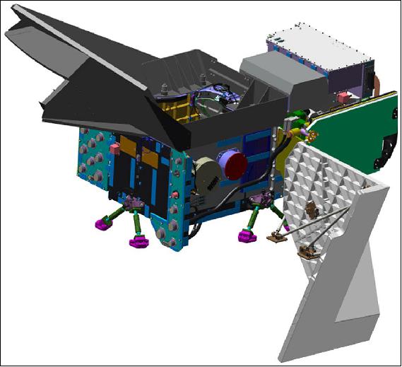
The Harris TANSO-FTS-2 features an IP (Intelligent Pointing) system that increases useful data collections in the presence of clouds. IP uses a high-resolution RGB infrared camera to identify cloud-free regions near the commanded LOS (Line of Site) position.
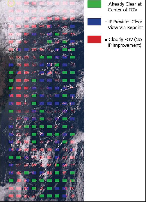
As shown in the color image of Figure 7, onboard processing uses the raw camera image to create a cloud mask and then determines, via a convolution, the least cloudy area of the FOV (Field of View). The instrument LOS is then shifted to the cloud-free region before the interferogram is collected.
In the example in Figure 8, the percentage of usable cloud-free data collects increases from 20% (green locations) to 46% (green plus blue locations), which is a 2.3 times improvement. Globally, IP is expected to provide a substantial improvement in the cloud-free data yield.

GOSAT-2 design feature | Mission benefits |
CrIS-based passive detector cooler | Inherently reliable, achieves temperatures needed for IR detectors |
New intelligent pointing function | Detects cloud-free areas and repoints scanner in real time to maximize the number of cloud-free measurements |
Highly accurate and stable scanner | Minimizes scene-induced interferogram fluctuations during data collects |
Very linear signal outputs | Minimizes radiance errors due to nonlinearity effects |
Interferometer improvements | More stable laser outputs and more stable zero path difference position |
Target for ILS characterization | Accurate on orbit ILS characterization in two spectral bands |
Multiple spectralon surfaces in solar calibration target | Excellent knowledge of solar calibration target radiances over life |
Flight-proven high-emissivity infrared calibration target | CrIS-based target provides emissivity >995% and temperature errors <100 mK for precise calibration accuracy |
Stabilized optical temperatures | Most of instrument is actively temperature controlled to provide enhanced calibration accuracy |
Stable scanner performance over life | Significant motor torque margin, full outgas of components, robust EMI shielding, reprogrammable servo coefficients |
Improved solar calibration accuracy | Glint shield prevents Earth radiance of spacecraft glints from impacting solar calibration accuracy |
ILS target uniformity | Integrating sphere ensures very good uniformity for best ILS calibration |
Minimized scanner disturbances to interferometer | Scanner peak torques avoid zero-velocity points of interferometer turnaround, which is most sensitive for zero path difference shifts |
Negligible stray light during calibration | Baffles to ensure no stray light impact to calibration |
Improved telemetry for IR calibration | Large number of accurate temperature sensors provide improved calibration corrections |
Fixed-rate sampling | Simplifies onboard processing while ensuring low-noise performance |
TANSO-FTS-2 measures high-resolution spectra of upwelling Earth radiance in 5 spectral bands (left) to extract concentrations of greenhouse gases (CO2, CH4) and artificial emission sources (CO). The development of TANSO-FTS-2 is being performed under a subcontract by Mitsubishi Electric Corporation, the GOSAT-2 prime contractor of the JAXA GOSAT-2 Project. 16)
Band | Spectral range (µm) | Wave numbers | Resolution | Mission purpose |
1 | 0.755 - 0.772 | 12,950 - 13,250 | 0.2 cm-1 | Total column oxygen; used to derive total column mass |
2 | 1.563 - 1.695 | 5900 - 6400 | 0.2 cm-1 | Total column carbon dioxide and methane |
3 | 1.923 - 2.381 | 4200 - 5200 | 0.2 cm-1 | Total column carbon dioxide, moisture and carbon monoxide |
4 | 5.56 - 8.45 | 1183 - 1800 | 0.2 cm-1 | Methane and moisture |
5 | 8.45 - 14.29 | 700 - 1183 | 0.2 cm-1 | Temperature profile, carbon dioxide |
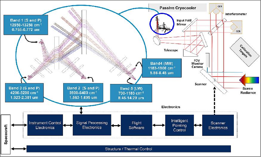
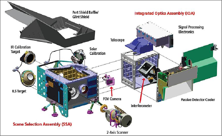
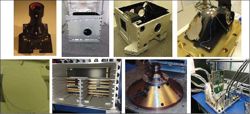
The TANSO-FTS-2 instrument has a mass of 225 kg and an average power consumption of 270 W.
TANSO-CAI-2 (Thermal and Near-infrared Sensor for Carbon Observation-Cloud and Aerosol Imager-2)
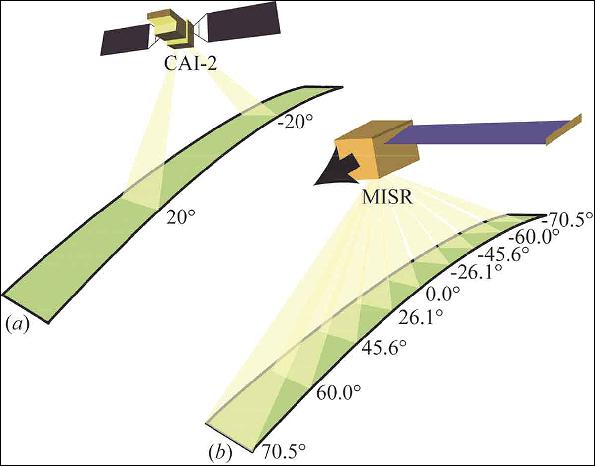
TANSO-CAI-2 is a push-broom imaging sensor that has forward- and backward-looking bands (±20º) for observing the optical properties of aerosols and clouds, and for monitoring the status of urban air pollution and trans-boundary air pollution over oceans. An important role of CAI-2 is to perform cloud discrimination in each direction. 17) 18)
GOSAT-2 has three instruments which can be used for cloud discrimination. (1) On-board camera (CAM) is a RGB camera. It points in the direction of TANSO-FTS-2 viewing and it has higher spatial resolution than TANSO-CAI-2. TANSO-FTS-2 has an intelligent pointing system. This system judges the presence or absence of clouds in IFOV of the TANSO-FTS-2 using the CAM in on-board processing, and automatically changes the pointing angle of the TANSO-FTS-2 if there are clouds. By this system, an increase in the probability of obtaining cloud-free TANSO-FTS-2 is expected. (2) CAI-2 has a near infrared (NIR, 0.87 µm) band and shortwave infrared (SWIR, 1.60 µm) band, which are effective in cloud detection. The CLAUDIA (Cloud and Aerosol Unbiased Decision Intellectual Algorithm) is employed by GOSAT for cloud discrimination.
The derivation of aerosol optical properties needs CAI-2 cloud discrimination. Under this situation, the CAM is used for the intelligent pointing system, the CAI-2 for cloud discrimination except thin cirrus, and the 2.0 µm of the FTS-2 for thin cirrus. CLAUDIA-CAI only uses the radiances of three (center wavelengths of 0.67, 0.87 and 1.60 µm) of the four bands (Table 6).
Items | GOSAT-2 | GOSAT | |
Spectral ranges (nm) | Forward viewing (+20º) b1: 333-353 | Backward viewing (-20º) b6: 370-390 | Nadir viewing b1: 370-390 b2: 664-684 |
Spatial resolution (nadir) | except band 5, 10 | band 5, 10 | band 1-3 band 4 |
Swath/FOV | every point on Earth to be observed at least twice, a recurrent cycle | band 1-3 band 4 | |
SNR | b1: >200 (45/0.158) | b6: >200 (48/0.152) | b1: >200 (47/0.149) b2: >200 (45/0.104) |
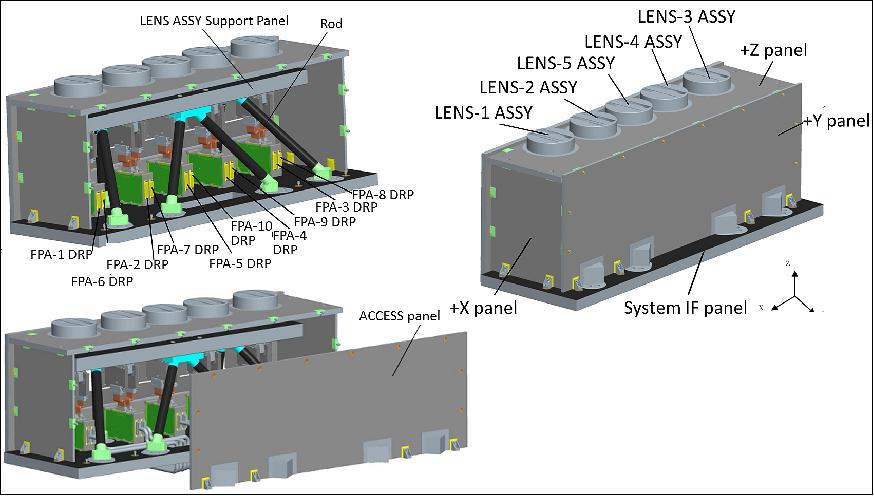
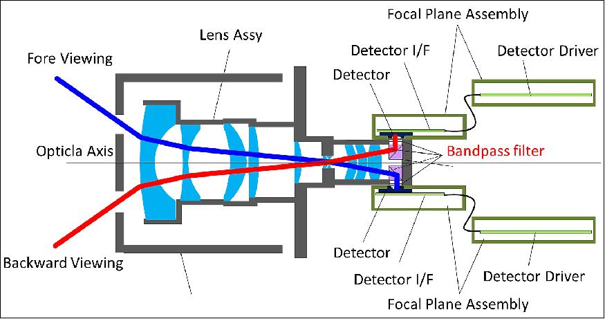
Meanwhile the ABO2 (A-band oxygen cloud screeningalgorithm) was developed. Although ABO2 can judge the presence or absence of clouds in IFOV of the FTS-2 without CAI-2, the processing time of cloud discrimination using the O2A-band is longer than using CAI-2. Furthermore, there is a possibility to take advantage of the aerosol optical properties derived using CAI-2 to reduce greenhouse gas retrieval uncertainty. The derivation of aerosol optical properties needs CAI-2 cloud discrimination. Under this situation, the CAM is used for the intelligent pointing system, the CAI-2 for cloud discrimination except thin cirrus, and the 2.0 µm of the FTS-2 for thin cirrus. CLAUDIA-CAI only uses the radiances of three (center wavelengths of 0.67, 0.87 and 1.60 µm) of the four bands (Table 6). The 1.60 µm band is used to discriminate clouds in bright desert areas (Figure 15).
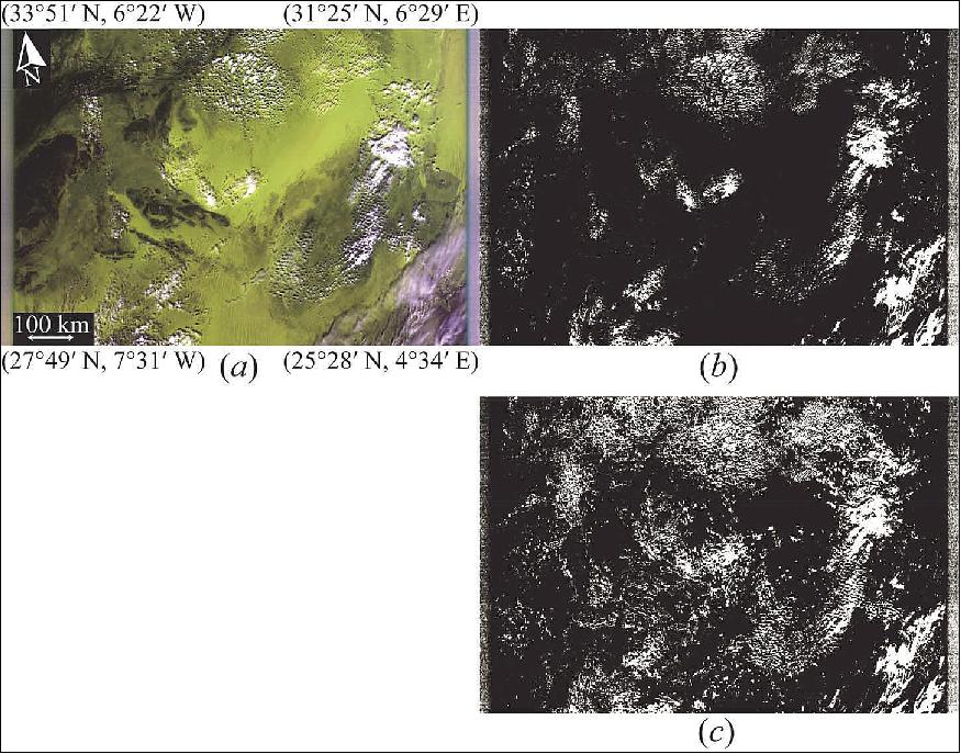
Although cloud discrimination will be performed in each direction, the use of the forward and backward cloud discrimination in the processing for the calculation of the greenhouse gases concentration was discussed. 20) Summarizing what is described in the article, it is necessary to make an addition of margins to the IFOV of the FTS-2 in a cloud discrimination result image depending on cloud moving by wind for the time difference between CAI-2 observation time and FTS-2 observation time. Thus, the difference between forward and backward cloud discrimination by CLAUDIA must be considered. Meanwhile, MISR (Multi-angle Imaging SpectroRadiometer) aboard Terra provides radiometrically and geometrically calibrated images for spectral bands at nine widely spaced angles (nadir, ±26.1°, ±45.6°, ±60.0° and ±70.5° forward and backward of the local vertical, Figure 12 (b). The center wavelengths of each of these bands are 0.45, 0.56, 0.67 and 0.87 µm. Therefore, it is possible to examine the difference in forward and backward CAI-2 cloud discrimination using the MISR 0.67 and 0.87 µm bands (CLAUDIA-MISR) at ±26.1° excluding bright desert areas.
The TANSO-CAI-2 instrument has a mass of 137 kg and a power consumption of 350 W (average in daytime;operation mode), 220 W (average in night time; stand-by mode). TANSO-CAI-2 will observe only during day time except for lunar calibration and electrical calibration.
References
1) Masakatsu Nakajima, Hiroshi Suto, Kazuhiko Yotsumoto, Masashi Abe, Akihiko Kuze, Kei Shiomi, Tomoaki Tanaka, Hiroshi Ohyama, Yumiko Tateshita, "Overview of the GOSAT-2 Mission," Proceedings of the 29th ISTS (International Symposium on Space Technology and Science), Nagoya-Aichi, Japan, June 2-8, 2013, paper: 2013-n-60
2) Masakatsu Nakajim, Akihiko Kuze, Hiroshi Suto, "GOSAT-2 - Mission Requirements and Specifications," Proceedings of the 63rd IAC (International Astronautical Congress), Naples, Italy, Oct. 1-5, 2012, paper: IAC-12, B1.2. 3
3) "Greenhouse gases Observing SATellite-2 (GOSAT-2)," JAXA, URL: http://global.jaxa.jp/projects/sat/gosat2/
4) "About Greenhouse gases Observing SATellite-2 (GOSAT-2)," JAXA, URL: http://global.jaxa.jp/projects/sat/gosat2/index.html
5) "Mitsubishi Electric Awarded Contract for GOSAT-2 Satellite System," Mitsubishi Electric, Release No 2807, Dec. 12, 2013, URL: http://www.mitsubishielectric.com/news/2013/pdf/1212.pdf
6) "Mitsubishi Electric Begins Developing GOSAT-2 Satellite System," Mitsubishi Electric, Release No 2837, April 9, 2014, URL: http://www.mitsubishielectric.com/news/2014/pdf/0409.pdf
7) Tsuneo Matsunaga, Isamu Morino, Yukio Yoshida, Makoto Saito and the NIES GOSAT-2 Project Team, "The Status of NIES GOSAT-2 Project," Proceedings of the IWGGMS-10 (10th International Workshop on Greenhouse Gas Measurements from Space) ESA/ESTEC, The Netherlands, May 5-7, 2014, URL: http://www.congrexprojects.com/2014-events/14c02/programme
8) "Exelis wins multimillion-dollar contract for climate-monitoring satellite payload," Exelis, May 20, 2014, URL: http://www.exelisinc.com/News/PressReleases/Pages/Exelis-wins-GoSat-Contract.aspx
9) http://www.gosat-2.nies.go.jp/about/spacecraft_and_instruments/
10) "Advanced Sensor Built by Harris is Delivered to Mitsubishi Electric Corporation for their GOSAT-2 Satellite," Satnews Daily, 13 June 2018, URL: http://www.satnews.com/story.php?number=1553571907
11) "Launch Results of the H-IIA F40 Encapsulating GOSAT-2 and KhalifaSat," JAXA Press Release, 29 October 2018, URL: http://global.jaxa.jp/press/2018/10/20181029_h2af40.html
12) Stephen Clark, "GOSAT-2 and KhalifaSat," Spaceflight Now, 16 May 2018, URL: https://spaceflightnow.com/launch-schedule/
13) "Analysis result of the proxy-method based retrievals from GOSAT-2 data : methane and carbon monoxide," NIES Press Release 5 July 2019, URL: http://www.nies.go.jp/whatsnew/20190705/20190705-e.html
14) "Ibuki-2 (GOSAT-2) completion of critical operations phase," JAXA Press Release, 30 October 2018, URL: http://global.jaxa.jp/press/2018/10/20181030_gosat2.html
15) "TANSO-FTS-2 Instrument for the GOSAT-2 Payload," Harris, URL: https://www.harris.com/sites/default/files/downloads/
solutions/tanso-fts-2_gosat-2_datasheet_d0801.pdf
16) Ronald Glumb, Peter Mantica, Alan Bell, Christopher Ellsworth, Lawrence Suwinski, and Jeremy Dobler, "Update on the TANSO-FTS-2 instrument for GOSAT-2," URL: http://www.nies.go.jp/soc/events/iwggms12/pdf/post/Poster_55_Ronald_Glumb.pdf
17) Yu Oishi, Takashi Y. Nakajima, Tsuneo Matsunaga, "Difference between forward- and backward-looking bands of GOSAT-2 CAI-2 cloud discrimination used with Terra MISR data," International Journal of Remote Sensing, Vol. 37 , Issue 5,pp: 1115-1126, 2016, http://www.tandfonline.com/doi/full/10.1080/2150704X.2016.1145822, URL: http://www.tandfonline.com/doi/pdf/10.1080/
2150704X.2016.1145822?needAccess=true
18) Yu Oishi, Haruma Ishida, Takashi Y. Nakajima, Ryosuke Nakamura, Tsuneo Matsunaga, "The Impact of Different Support Vectors on GOSAT-2 CAI-2 L2 Cloud Discrimination," Remote Sensing. 2017, 9, 1236; doi:10.3390/rs9121236, URL: https://res.mdpi.com/remotesensing/remotesensing-09-
01236/article_deploy/remotesensing-09-01236.pdf?filename=&attachment=1
19) Information provided by Dr. Masakatsu Nakajima, the mission manager of GOSAT-2 of JAXA.
20) Y. Oishi, T. M. Nagao,H. Ishida, T. Y. Nakajima, T. Matsunaga. 2015b. "Preliminary Study of a Method Using the GOSAT-2 CAI-2 Cloud Discrimination for Screening of Cloud-Contaminated FTS-2 Data." [In Japanese with English abstract.] Journal of Remote Sensing Society of Japan 35 (5): pp: 299–306
The information compiled and edited in this article was provided by Herbert J. Kramer from his documentation of: "Observation of the Earth and Its Environment: Survey of Missions and Sensors" (Springer Verlag) as well as many other sources after the publication of the 4th edition in 2002. - Comments and corrections to this article are always welcome for further updates (eoportal@symbios.space).
Spacecraft Launch Mission Status Sensor Complement References Back to Top