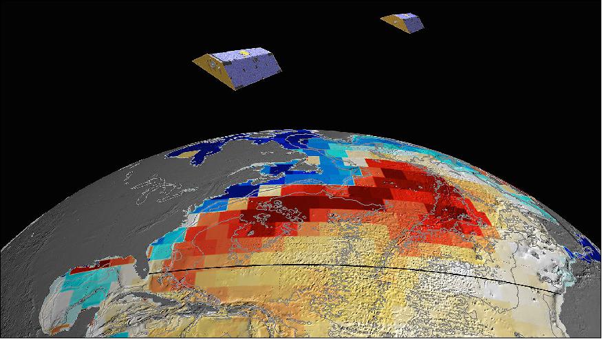
GRACE (Gravity Recovery And Climate Experiment)
EO
ESA
Ocean
NASA
GRACE satellites mapped detailed measurements of the global gravitational fields with unprecedented precision. Data from GRACE satellites covered wide application areas.
Quick facts
Overview
| Mission type | EO |
| Agency | ESA, NASA, DLR, GFZ |
| Mission status | Mission complete |
| Launch date | 17 Mar 2002 |
| End of life date | 27 Oct 2017 |
| Measurement domain | Ocean, Land, Gravity and Magnetic Fields |
| Measurement category | Gravity, Magnetic and Geodynamic measurements, Ocean topography/currents, Soil moisture |
| Measurement detailed | Magnetic field (scalar), Magnetic field (vector), Soil moisture at the surface, Ocean dynamic topography, Gravity field |
| Instruments | GRACE instrument |
| Instrument type | Gravity instruments |
| CEOS EO Handbook | See GRACE (Gravity Recovery And Climate Experiment) summary |
Related Resources
Summary
Mission Capabilities
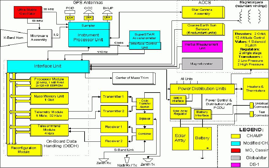
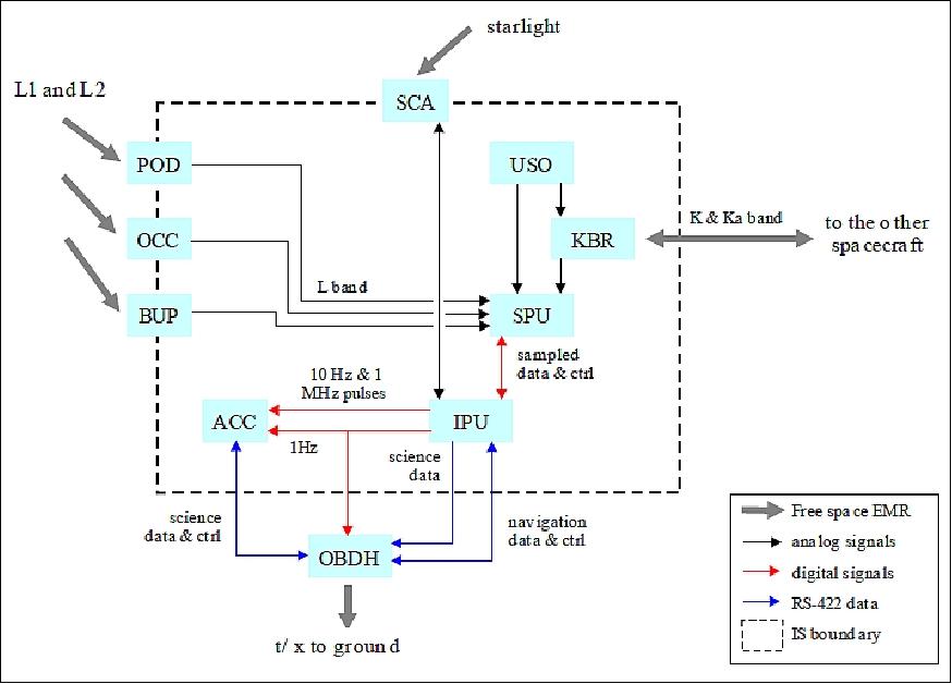
GRACE carried the Science Instrument System (SIS) and K/Ka-Band Ranging (KBR) instrument.
SIS included all elements of the inter-satellite ranging system, the Global Positioning System (GPS) receivers required for precision orbit determination and occultation experiments, and associated sensors such as Star Camera Assembly (SCA). It also coordinated the integration activities of all sensors, assuring their compatibility with each other and the satellite.
KBR detected instantaneous, extremely small changes in the distance between the two satellites and used this information to make gravitational measurements with a level of precision that had never been possible before.
Performance Specifications
GRACE-1 led GRACE-2, with the onboard cold-gas propulsion system used to separate the two satellites at a distance of 170 km to 270 km. The GRACE system accuracy was sufficient to determine a change in mass equivalent to a volume of water with a depth of 0.01 m over a radius of about 400 km. GRACE had a 30 days repeat cycle to determine the new gravity field each month.
The two satellites, GRACE-1 and GRACE-2, were initially in a circular polar co-planar orbit at an altitude of 500 km, which eventually decayed to 300 km, and were at an inclination of 89°.
Space and Hardware Components
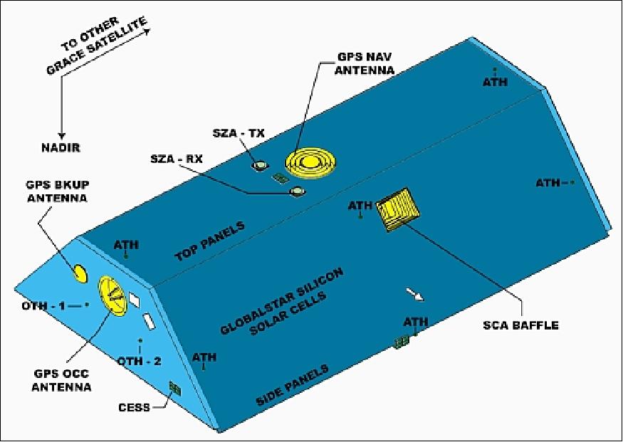
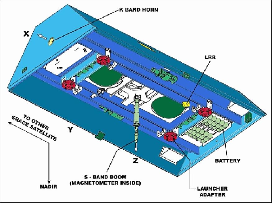
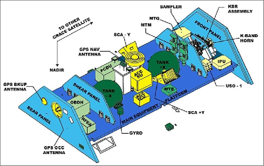
GRACE enabled the FLEXBUS structure designed by Astrium. It consisted of Carbon Fibre Reinforced Plastic (CFRP), a material with a very low coefficient of thermal expansion that provided the dimensional stability necessary for precise range change measurements between the two satellites. GRACE was a three-axis stabilised Altitude and Orbit Control System (AOCS) that consisted of different sensors such as Coarse Earth Sun Sensor (CESS), boom-mounted Forster magnetometer, Star Camera Assembly and the BlackJack high precision sensors. The Inertial Measurement Unit (IU) was an optical gyroscope that provided three-axis information in survival mode.
The actuators included a cold gas system with 12 attitude control thrusters and two orbit control thrusters, each rated at 40 mN and three magnetorquers.
GRACE (Gravity Recovery And Climate Experiment)
Spacecraft Launch Mission Status Sensor Complement References
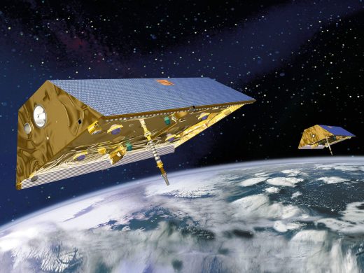
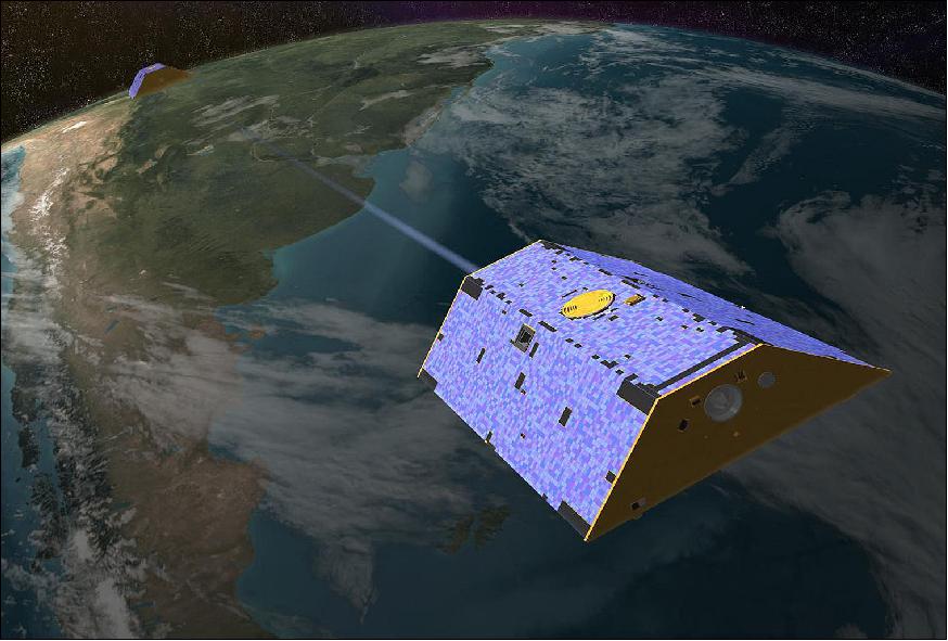
GRACE is an international cooperative US-German dual-minisatellite SST (Satellite-to-Satellite Tracking) geodetic mission with the overall objective to obtain long-term data with unprecedented accuracy for global (high-resolution) models of the mean and the time-variable components of the Earth's gravity field (a new model of the Earth's gravity field every 30 days for five years). GRACE is also part of NASA's ESSP (Earth System Science Pathfinder) program.
Some science objectives are: 1) 2)
• To enable a better understanding of ocean surface currents and ocean heat transport
• To measure changes in the sea-floor pressure
• To study ocean mass changes
• To measure the mass balance of ice sheets and glaciers
• To monitor changes in the storage of water and snow on the continents
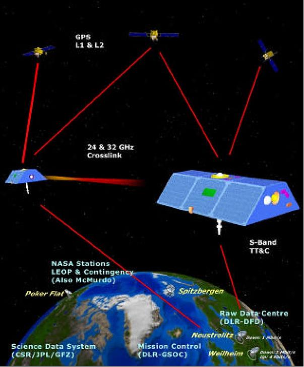
The mission concept makes use of measurements of the inter-satellite range changes and its derivatives between two co-planar satellites (in low-altitude and polar orbits), using a microwave tracking system. The orbits of the two separately flying S/C are perturbed differently in the Earth's gravity field, leading to inter-satellite range variations. In addition, each S/C carries a GPS receiver of geodetic quality and high-accuracy accelerometers to enable accurate orbit determination, spatial registration of gravity data and the estimation of gravity field models.
The fluctuations in the strength of the Earth's gravity field reflect in turn changes in the distribution of mass in the ocean, atmosphere, and solid Earth, and in the storage of water, snow, and ice on land. Since ocean bottom pressure represents a column integral of the mass of the atmosphere plus the ocean, this measurement technique permits the deduction of ocean bottom pressure changes from space.
GRACE is a collaborative endeavour involving the Center for Space Research (CSR) at the University of Texas, Austin (UTA/CSR); NASA's Jet Propulsion Laboratory, Pasadena, CA; the German Space Agency (DLR) and Germany's National Research Center for Geosciences (GFZ), Potsdam.
Note: A renaming of GFZ took place on June 17, 2008. The new name is: Helmholtz-Zentrum Potsdam GFZ German Research Center for Geosciences. 3)
The GRACE mission is led by B. Tapley (PI) of the University of Texas at Austin and by Frank Flechtner (Co-PI) of GFZ (GeoForschungsZentrum), Potsdam. NASA/JPL has led the S/C development in partnership with EADS Astrium GmbH (formerly DASA/DSS, Friedrichshafen) and SS/L (Space Systems/Loral). Astrium has provided major elements of two flight satellites based on the existing CHAMP S/C bus. SS/L provides the attitude control system, microwave instrument electronics and system and environmental testing. DLR/GSOC performs mission operations with tracking stations at Weilheim and Neustrelitz. Science data distribution/processing is managed in a cooperative approach by JPL and UTA/CSR (University of Texas at Austin/Center for Space Research) in the US and GFZ in Germany. Germany provides also the Eurockot launch vehicle.
Spacecraft
Both S/C structures are of identical design. The shape of each satellite is trapezoidal in cross-section, based on the FLEXBUS design of Astrium (length = 3122 mm, height = 720 mm, bottom width = 1942 mm, top width = 693 mm) The FLEXBUS structure consists of CFRP (Carbon Fiber Reinforced Plastic). This material, with a very low coefficient of thermal expansion, provides the dimensional stability necessary for precise range change measurements between the two spacecraft.
Each Earth-pointing S/C is three-axis stabilized by AOCS (Attitude and Orbit Control System) consisting of sensors, actuators and software.
The sensors include: 4)
• CESS (Coarse Earth Sun Sensor) for omnidirectional, coarse attitude measurement in the initial acquisition, survival and stand-by modes of the satellite. One CESS sensor is mounted on each of the six sides of the satellite. The resulting Earth vector has an accuracy of ~5-10º, and the sun vector ~3-6º (there is a dependence upon orbit geometry).
• A boom-mounted Förster magnetometer provides additional rate information. Magnetometer measurements of the magnetic field are used in conjunction with the CESS in safe mode and for the commanding of the torque rods in fine-pointing mode.
• The high-precision sensors are SCA (Star Camera Assembly) of ASC heritage (flown on Ørsted), and the BlackJack (GPS Flight Receiver), see description under CHAMP.
• An IMU (Inertial Measurement Unit) an optical gyro providing 3-axis rate information in survival modes.
The actuators include a cold gas system (with 12 attitude control thrusters and two orbit control thrusters, each rated at 40 mN) and three magnetorquers.
Each S/C has a mass of 432 kg (science payload = 40 kg, fuel = 34 kg); the S/C power is 150-210 W (science payload = 75 W). The top and side panels of each S/C are covered with strings of silicon solar cells; NiH batteries with 16 Ah provide power storage. The S/C design life is five years. About 80% of the spacecraft's onboard electronics parts are COTS (Commercial Off-the-Shelf) products.
Launch
A dual launch on a Eurockot vehicle took place on March 17, 2002, from Plesetsk, Russia. The re-ignitable third stage, BREEZE-KM, was used to place both satellites in the same nominal orbit. Following separation, the leading GRACE satellite began pulling away from the trailing satellite at a relative speed of about 0.5 m/s to assume its nominal position of 220 km ahead of the trailing satellite. At launch, the twin pair of both GRACE spacecraft was immediately nicknamed "Tom and Jerry."
Orbit:
Circular polar co-planar orbit (non-repeat ground track); the initial altitude is 485 km at launch (near a solar maximum), decaying to about 300 km (near a solar minimum) after five years; inclination = 89º. The two satellites in tandem formation are loosely controlled, they are separated at distances between 170 to 270 km apart. GRACE-1 is leading GRACE-2. The onboard cold-gas propulsion system is being used to maintain the separation between 270 km and 170 km. Since the mission launch, orbit maneuvers have been needed about every 50 days to do this.
- The rather low orbital altitude is selected to obtain the best possible gravity measurements (note that the gravity signal of any central body is decaying with the square of the orbital distance from the center of mass) taking into account all decaying (drag) effects.
The spacecraft orbits have a 30-day repeat cycle, and a new gravity field is determined each month. The GRACE system accuracy is sufficient to determine a change in mass equivalent to a volume of water with a depth of 1 cm over a radius of about 400 km.
RF communications:
The TT&C activities are carried out using a pyro-deployed S-band receive and transmit antenna, mounted on a nadir-facing deployable boom. A backup zenith receives antennae and a backup nadir transmit antenna (SZA-Tx), along with the appropriate RF electronics assembly, complete the telemetry and telecommand subsystem. The daily science data volume is about 50 MByte, including gravity data and GPS occultation data. CCSDS protocols are used for all data communication.
The S-band frequencies for the two satellite systems are:
• Downlink: 2211.0 MHz for satellite 1 and 2260.8 MHz for satellite 2. Modulation: BPSK/NRZ is modulated onto the subcarrier which is PM modulated onto the uplink carrier. The data rate is 32 kbit/s for real-time data and 1 Mbit/s for dump data.
• Uplink: 2051.0 MHz for satellite 1 and 2073.5 MHz for satellite 2. Modulation: BPSK/NRZ.
In addition, GFZ installed two automatic payload data acquisition stations on Svalbard (Ny Alesund), one for CHAMP and one for GRACE, to speed up the data processing and distribution chain for the various weather services. The polar location of Svalbard makes it possible to have access to the data on almost all orbits.
Mission Status
GRACE was launched on 17 March 2002 and completed science observations on 27 Oct. 2017.
• May 13, 2019: The U.S.-German Gravity Recovery and Climate Experiment (GRACE) mission, active from 2002 to 2017, continues to play a crucial role in advancing our understanding of Earth's water dynamics. GRACE's data, which measured changes in gravitational pull related to shifts in Earth's mass, have far-reaching implications, including monitoring ice loss in Greenland and Antarctica, tracking groundwater depletion in California, and explaining Earth's rotational wobbles. A new paper, "Contributions of GRACE to Understanding Climate Change," led by Byron Tapley, GRACE's original principal investigator, highlights the mission's significant contributions to climate science. By measuring gravitational changes caused by moving water, GRACE has enabled scientists to grasp water's role in the planet's health, leading to insights into global climate patterns and their evolution. The GRACE mission's innovative approach to tracking changes in Earth's mass provides invaluable data in a world where water movements are often challenging to monitor. The mission's twin satellites, GRACE and GRACE Follow-On, have allowed researchers to create monthly global maps of mass changes, enhancing our understanding of climate change's impact on water distribution in the ocean, ice, and continents. The mission's contributions to climate science underscore its uniqueness and essential role in assessing climate change's effects on Earth's water systems. 6)
• April 16, 2019: A recent review published in the journal "Nature Climate Change," authored by Frank Flechtner, Christoph Reigber, Christoph Dahle, Henryk Dobslaw from the Helmholtz Center Potsdam German Research Center for Geosciences GFZ, and Ingo Sasgen from the Alfred Wegener Institute, Helmholtz Center for Polar and Marine Research, highlights the invaluable contributions of the GRACE mission in climate research. As revealed in the article, the GRACE mission precisely measured changes in Earth's gravitational field, offering insights into Earth's water dynamics and climate change. It provided direct measurements of ice-mass loss from ice sheets and glaciers, attributing mass loss to Arctic warming and increased ice flow into the ocean. The mission unveiled changes in the terrestrial water cycle, groundwater depletion rates, and their connection to sea-level change, aiding climate model validation. GRACE also enhanced drought monitoring and flood risk identification, offering valuable climate service applications. Its successor, GRACE Follow-on, continues to provide critical data for climate research. As detailed in the journal review, GRACEC significantly advanced our understanding of Earth's climate system by precisely measuring gravitational changes, ice-mass loss, terrestrial water storage, sea-level rise, and climate-related applications. 7)
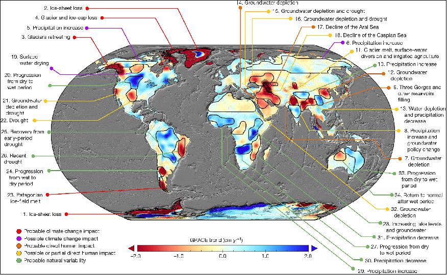
• May 16, 2018: In a first-of-its-kind study featured in the journal "Nature," researchers, led by Matt Rodell of NASA's Goddard Space Flight Center, employed a novel approach by integrating data from multiple NASA satellites with human activity information to map alterations in global freshwater distribution in 34 regions around the world (Figure 8). Spanning a 14-year period, the study revealed a consistent pattern whereby wet regions were experiencing increased precipitation, while dry areas were becoming drier. These changes are attributed to a combination of factors, encompassing human water management practices, climate change, and natural climate cycles. Through a meticulous analysis that incorporated data from the GRACE spacecraft mission, as well as sources like precipitation records, Landsat imagery, irrigation maps, and reports on human activities, the researchers elucidated the driving forces behind these trends. This comprehensive perspective enabled them to distinguish between natural variability, climate change influences, and the impact of human activities on terrestrial water storage. The findings underscore the intricate dynamics at play in global freshwater distribution, delivering valuable insights for assessing climate change impacts and enhancing water resource management strategies. The research highlights a pivotal shift towards comprehending Earth's hydrological dynamics by merging satellite-based observations with human-induced changes, offering a more holistic understanding of how freshwater distribution is evolving globally. This multidimensional approach illuminates the interplay between natural variability, human activities, and climate change, providing vital insights into how these factors are reshaping our planet's freshwater landscape. 9) 10)

• March 10, 2018: The GRACE-1 satellite reentered the atmosphere. 11)
• December 21, 2017: NASA researchers have identified a paradox in the relationship between winter moisture levels and subsequent wildfire frequency. Contrary to expectations, wetter winters lead to an increase in small wildfires during the following fire season, while dry winters result in fewer large fires. The study, which analyzed data from 2003 to 2012 and correlated wildfire occurrences with soil moisture measurements from the GRACE satellite mission, helps shed light on the role of fuel moisture in wildfires. The findings suggest that an abundance of dry, dead plant material following a wet winter contributes to more small fires, whereas trees and larger shrubs, which retain moisture, can limit the spread of small fires in landscapes containing trees. This research may assist in predicting the severity of future fire seasons by understanding the role of fuel moisture. The study's innovative use of satellite data to correlate soil moisture levels and wildfire frequency offers valuable insights into the complex interplay between environmental factors and fire activity. Wet winters spur the growth of dry, flammable vegetation, increasing the likelihood of smaller fires, while drier conditions tend to hinder large fires. This research, underpinned by data from the GRACE satellite mission, demonstrates the potential for remote sensing technology to provide early warning signs for wildfire risk, enhancing our understanding of wildfire dynamics and facilitating improved prediction of fire season outcomes. 12)
• October 27, 2017: After over 15 years of successful operation, the GRACE satellite mission has concluded its science operations. The mission involved a pair of satellites, GRACE-1 and GRACE-2, which precisely measured the distance between them to track changes in Earth's gravity field, revealing insights into the movement of liquid water, ice, and the solid Earth. GRACE has provided crucial information about Earth's changing seasons, weather, climate processes, and the effects of earthquakes and human activities, such as aquifer depletion. The mission's innovative use of technology to measure gravitational changes has improved scientific understanding of Earth and provided valuable data for environmental monitoring and forecasts worldwide. While GRACE-2 has been decommissioned due to battery issues, GRACE-1 will continue operating until the end of 2017. The GRACE mission, led by Principal Investigator Byron Tapley at the University of Texas at Austin, has made significant contributions to understanding Earth's complex systems. It has helped monitor ice loss from Earth's ice sheets, contributed to sea-level rise and ocean circulation studies, and provided insights into groundwater changes, drought, and solid Earth dynamics. The mission's legacy will be carried forward by GRACE Follow-On, a joint NASA and German Helmholtz Center Potsdam GFZ mission scheduled for launch in early 2018. GRACE Follow-On will continue GRACE's work and test a new laser-ranging interferometer for future gravitational research satellites, ensuring the mission's legacy lives on. 14) 15)
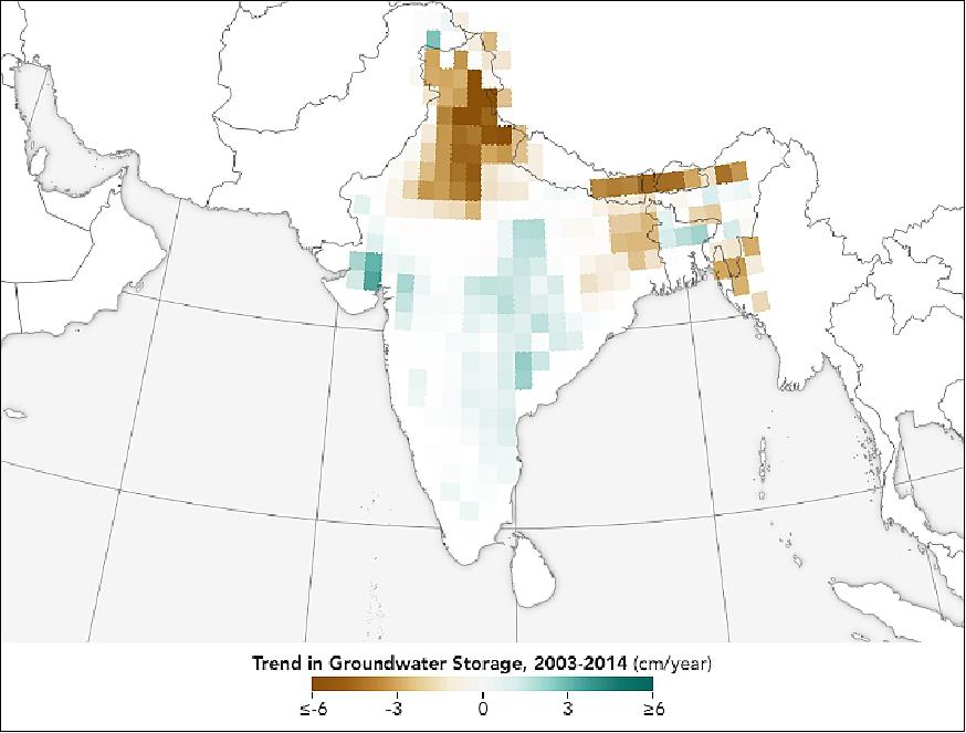
• September 22, 2017: New research reveals a glimmer of hope in India's ongoing water crisis. Groundwater, which has been significantly depleted in many parts of the country, is showing signs of rebounding in certain regions, as can be seen in Figure 12. Studies have highlighted India's substantial groundwater withdrawal, accounting for 25 percent of the global total in 2011, mainly for irrigation. However, recent data from the GRACE (Gravity Recovery and Climate Experiment) satellites between 2003 and 2014 indicate a positive shift. Western and southern parts of the country, including states like Gujarat and Andhra Pradesh, have experienced groundwater gains, largely attributed to policy changes in groundwater management, a reduction in power use for agriculture, and increased irrigation via surface water. Despite these encouraging findings, some areas, particularly in northern and eastern India, continue to face rapid groundwater depletion, highlighting the need for sustainable management practices to preserve this critical resource. 16) 17)
• September 14, 2017: After over 15 years in orbit, GRACE is making preparations for a final science data collection phase. A recent setback occurred when one of the GRACE-2 satellite's battery cells ceased functioning due to age-related issues, marking the eighth battery cell loss since the mission's launch in 2002. However, after losing contact with GRACE-2, the mission operations team successfully restored communications by bypassing the satellite's flight software system. They found that the affected battery cell had recovered its voltage, and the satellite had essentially hibernated without consuming fuel during the period of lost contact. As a result, the GRACE mission's dual satellite science phase is expected to continue through October and November, with the next data collection phase. This additional monthly gravity map will contribute to extending GRACE's data record until the launch of its successor mission, GRACE-Follow-On, scheduled for early 2018. After the dual satellite science phase concludes, the mission will proceed with the final decommissioning of both GRACE-1 and GRACE-2, following the directives of the mission's Joint Steering Group. 18)
• March 17, 2017: On its 15th anniversary in orbit, the GRACE mission remains a revolutionary force in Earth science, unlocking the mysteries of how water moves around our planet. Launched in 2002, GRACE has transformed our understanding of the Earth's water cycle by measuring changes in mass, revealing hidden secrets of the water cycle from space. Its data have led to groundbreaking discoveries, including the identification of unknown groundwater depletion, dramatic ice loss from Greenland and Antarctica, and insights into the global water cycle. GRACE's innovative approach involves tracking the changing distance between twin satellites caused by variations in Earth's gravitational pull due to shifts in water mass on or near the planet's surface. This technology has enabled scientists to measure the movement of water, ice, and solid Earth more accurately than ever before. Key findings include identifying areas where groundwater is being rapidly depleted, providing data for drought risk assessment, measuring ice sheet loss, and monitoring sea level changes, which have advanced our understanding of Earth's complex systems. Despite GRACE's aging spacecraft, the mission's groundbreaking legacy will continue with GRACE-FO (GRACE Follow-On), scheduled for launch in late 2017 to early 2018. GRACE-FO will build upon GRACE's successes, offering the potential for even more accurate measurements through new laser-ranging instruments, ensuring that the revolutionary exploration of Earth's water cycle continues into the next decade. 19)
• December 8, 2016: The twin GRACE satellites are labelled GRACE-1 and GRACE-2 by the Operations Team. The GRACE-1 satellite continues to collect nominal science data as before. The GRACE-2 satellite collects data in reduced circumstances. The accelerometer on GRACE-2 is turned off. The K-band instrument collects inter-satellite ranging data in the sunlight and through partial shadow. All the spacecraft functions are carried out nominally as long as shadows are short. When the shadows grow long, the diminished battery capacity can affect the spacecraft's functions in the shadow. The current mission operations strategy is intended to maximize the chances of safe passage through such a regime. The first indications are that the data collected - using this strategy - during November 2016, can be used to deliver credible science data products. 20)
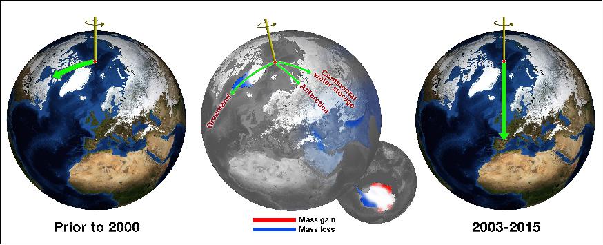
• October 7, 2016: The 2016 GRACE Science Team Meeting (GSTM) took place at GFZ (GeoForschungszentrum) in Potsdam, Germany, where it was discussed that the GRACE mission, originally designed for a five-year lifespan, had been in operation for 14.6 years and experienced operational degradation. Key mission lifetime issues included altitude decay, battery capacity, and propellant for attitude control, all of which raised questions about the mission's future. Various gravity models were developed during the mission, such as GGM05S, GGM05G, and GGM05C, each with distinct characteristics. GRACE also produced rapid products with a 24-hour latency, catering to applications like emergency management, drought monitoring, and more. The report mentioned a study presented at the meeting about GRACE-derived interannual hydrospheric and cryospheric mass budgets impacting Earth's rotation. This study revealed that hydrologic changes significantly contributed to a shift in polar motion, alongside the previously hypothesized ice sheet changes, with polar motion exhibiting an amplitude of (83 ± 23%) and a mean directional shift within 5.9° ± 7.6°, as illustrated in Figure 13. 21)
- The overlap of the GRACE mission with GRACE-FO (GRACE Follow-On) was emphasized as crucial for continuing climate change observations and maintaining data quality. The report highlighted the need for resolving differences in scientific conclusions between the two missions and the importance of cross-calibration. The multinational mission operations team worked to minimize the data gap between the two missions. GRACE-FO was expected to launch in early 2018 in collaboration with SpaceX. 22) 23)
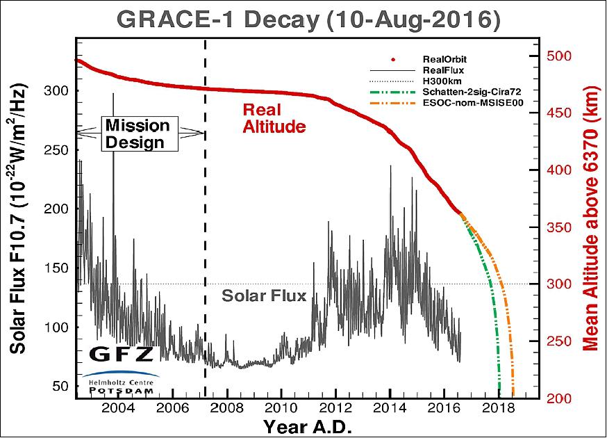
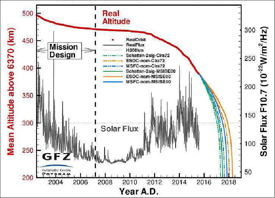
Legend to Figure 13: The reentry predictions depend on the accuracy of neutral density models and the accuracy of predictions for planetary geomagnetic index (Ap) and the solar flux (F10.7 cm).
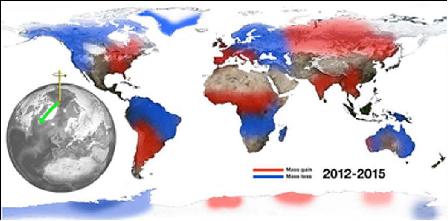
• April 2016: NASA scientists have used satellite data to unravel two mysteries surrounding the wobbles in Earth's rotation. One mystery, over a century old, is related to shifts in the planet's true pole and polar motion. The other mystery is the recent eastward shift of the north pole. While climate change is believed to be responsible for both phenomena, the exact mechanisms were unclear until now. The research, led by Surendra Adhikari at NASA's Jet Propulsion Laboratory, studied the movement of water around the Earth and its impact on the planet's rotational wobbles. They found that changes in water distribution, particularly in Eurasia, played a significant role in both the recent shift of the north pole and the historical east-west wobble in Earth's rotation. The study used data from the GRACE (Gravity Recovery and Climate Experiment) satellites to analyze changes in water mass across the globe. While ice mass loss from Greenland and Antarctica contributed to the eastward shift of the spin axis, the researchers discovered that the deficit of water in Eurasia, caused by factors like aquifer depletion and drought, had an even more substantial effect. The study's findings not only explain these rotational phenomena but also suggest that the historical record of east-west wobbles in Earth's spin axis can serve as a valuable indicator of changes in land water storage and past climate variations. Overall, this research enhances our understanding of Earth's dynamic behavior and its sensitivity to changes in water distribution, providing valuable insights into past and future climate patterns. 24) 25) 26)
• March 17, 2016: The GRACE mission has been on orbit for 14 years, almost 10 years past the planned mission lifetime- an impressive milestone. The twin satellites have been experiencing degradation in battery performance since 2011. Nevertheless, the twin spacecraft continue to function and collect nominal science data at this time. The GRACE team is carefully managing the satellite propellant and the remaining battery life for both satellites, developing and testing procedures for adjusting loads and for adjusting attitude to minimize solar power production to help facilitate lower battery temperature, should this capability be necessary. Best estimates at present suggest that the effects of atmospheric drag will end the mission sometime between mid-2017 and the first quarter of 2018. It is expected that nominal science data will be collected during the remainder of the mission life. 27)
- Current mission operation efforts are focused on extending mission life to allow for overlap with the GRACE Follow-On (GRACE-FO) mission, which is scheduled for launch in late 2017. The multinational mission operations team at GSOC (German Space Operations Center), GFZ, JPL, and UT/CSR, together with industry support, continues to work towards minimizing any data gap that might occur before GRACE-FO continues these measurements into the next decade.
• February 29, 2016: NASA's GRACE (Gravity Recovery and Climate Experiment) data is being used in Pakistan to monitor and manage groundwater resources more effectively. Pakistan, heavily reliant on irrigation, now pumps over 60% of its water from underground reservoirs. A partnership between the University of Washington, Seattle, and the Pakistan Council of Research in Water Resources has enabled the use of GRACE satellite data to provide monthly updates on groundwater storage changes in the Indus River basin. This helps identify areas experiencing depletion and those with adequate recharge. Satellite data offers a cost-effective alternative to traditional groundwater monitoring efforts, enabling more sustainable resource management. 28)
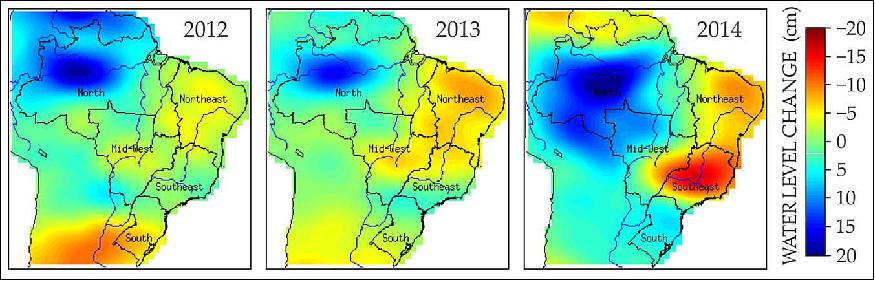
• December 3, 2015: In southeastern Brazil, a severe drought has become the country's worst since the 1920s, leading to water rationing in cities like São Paulo and declining crop yields. To gain a comprehensive view of the drought's impact, Augusto Getirana of NASA's Goddard Space Flight Center turned to data from the GRACE (Gravity Recovery and Climate Experiment) mission. GRACE consists of two spacecraft that measure Earth's gravitational changes, which are influenced by shifts in liquid and frozen water. Getirana used GRACE maps, as shown in Figure 17, to track the seasonal variations in water above and below ground, demonstrating how gravitational data can help understand the link between global climate shifts and local water conditions. 29)
• November 9, 2015: As of the latest update on the status of GRACE's science instruments, the accelerometers and the microwave assembly have remained turned off since September 27, 2015, data collection is ongoing for the GPS and star camera systems, and the spacecraft's current conditions are characterized by a β' = -1.6º, an altitude of 374 kilometers, and a separation distance between the two spacecraft of 138 kilometers. 30)
• November 2, 2015: In a joint effort between NASA and various universities, scientists have found a novel way to utilize satellite data, specifically from the GRACE mission, to track alterations in Atlantic Ocean currents, which play a vital role in global climate patterns. This innovative approach offers a means to enhance the monitoring and comprehension of changes occurring in ocean circulation and their implications for future climate dynamics. The AMOC (Atlantic Meridional Overturning Circulation) is a key component of ocean currents, transporting warm water from the tropics northeastward and eventually sinking and flowing back south after shedding heat, impacting the global climate. Researchers believe that changes in AMOC are a crucial indicator of the Earth's response to rising greenhouse gas levels. Recent indications suggest that the AMOC may be weakening and moving less water, a trend expected due to global warming. By employing GRACE satellite data, scientists aim to achieve consistent, comprehensive observations of the entire Atlantic Ocean, allowing for improved predictions and understanding of ocean current shifts.
- This groundbreaking satellite approach relies on the GRACE mission, which offers monthly records of slight changes in Earth's gravitational field. These changes result from variations in mass beneath the satellites, such as water redistributions due to ice sheet melting or groundwater pumping. The study's lead researcher, Felix Landerer of NASA's Jet Propulsion Laboratory, and his team have successfully extracted valuable information from the GRACE data, revealing tiny pressure differences at the ocean floor caused by deep ocean currents. By measuring the easternmost and westernmost points of this signal with high precision, they can assess the north-south flow of water throughout the entire Atlantic region. The results are in good agreement with data from a network of ocean buoys, known as RAPID, near 26º north latitude, offering confidence that this technique can be expanded to provide estimates for the entire Atlantic Ocean, aiding in the better monitoring of AMOC changes and their potential consequences for global climate systems. 31) 32)
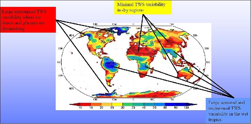
• October 2015: The GRACE mission, operational for 13.5 years as of September 2015, provides a unique perspective on Earth's water cycle through its precise gravity field observations. It offers quantitative estimates of terrestrial water storage (TWS) changes at monthly resolution from 2002 to 2014. GRACE's observations encompass diverse elements of the Earth's water cycle, including shifts in ocean surface and deep currents, variations in runoff and groundwater storage on land, exchanges between ice sheets or glaciers and the oceans, and alterations in mass distribution within the Earth. The mission also contributes to a better understanding of the Earth's atmosphere. GRACE's applications extend to studying water cycle extremes. It aids in comprehending global moisture dynamics and identifying trends in terrestrial water storage during its 13-year observation period, which may indicate hydroclimatic changes, direct human impacts, or natural interannual variability. These GRACE observations of maximum or minimum TWS (Terrestrial Water Storage) during the mission period align with other measures of water cycle extremes, including precipitation anomalies, reported droughts, and floods. Enhancements in flood risk and drought monitoring are achieved through data assimilation techniques, resulting in improved spatial and temporal resolution, reduced data latency, and vertical disaggregation of TWS observations. Future directions include the development of drought/flood forecasting capabilities and global wetness/drought monitoring. 33) 34) 35)
• June 2015: the NASA Senior Review extended the GRACE mission through 2019. Operations are focused on extending mission life to overlap with GRACE-FO. Since its launch in 2002, the GRACE mission has produced a series of over 140 global gravity models, providing an unprecedented view of mass redistribution within the Earth system on monthly to inter-annual time scales. These gravity variations result primarily from the transport of water between the oceans, land, cryosphere and atmosphere, making GRACE a unique and important component of NASA's climate measurement capability; it was designated a Climate Mission in the 2010 ESD Climate Initiative. 36)
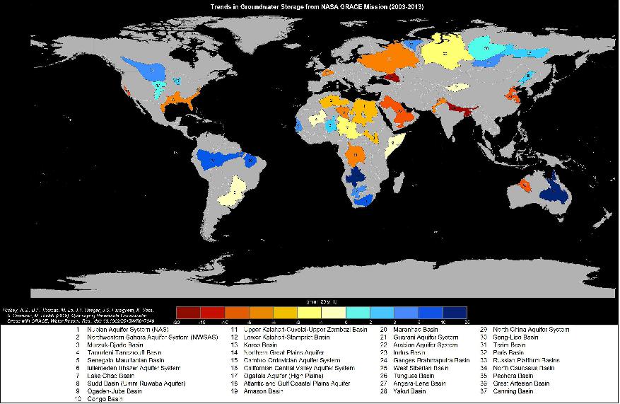
• June 16, 2015: Two groundbreaking studies led by the University of California, Irvine (UCI), using data from the GRACE (Gravity Recovery and Climate Experiment) satellites, have unveiled alarming trends in the depletion of the world's largest groundwater basins. The research signifies that human consumption is depleting these critical aquifers at an accelerated pace, yet there exists limited to no precise data regarding their remaining water reserves. As a consequence, significant portions of the global population are depleting groundwater reserves without knowing when these resources may become exhausted. In the first study, the researchers investigated 37 of the world's largest aquifers from 2003 to 2013. They identified eight of these aquifers as severely overstressed, with minimal natural replenishment to offset usage. An additional five aquifers were deemed extremely or highly stressed, depending on the level of replenishment each received, indicating an ongoing crisis. The most severely affected aquifers are situated in the driest regions of the world, where underground water is heavily relied upon, and the predicament is expected to worsen with climate change and population growth. The study's findings also pinpoint the Arabian Aquifer System, a critical water source for over 60 million people, as the world's most overstressed aquifer. The Indus Basin aquifer in northwestern India and Pakistan ranked second, with the Murzuk-Djado Basin in northern Africa in third place. Even California's Central Valley, primarily used for agriculture and experiencing rapid depletion, was classified as highly stressed in the study. 37) 38)
• May 13, 2015: The GRACE operations status depends on the health of the battery and the duration within each orbit when the battery is in use. The accelerometers on both satellites and the MWAs were turned off in May 2015, while the GPS and star camera data are being collected continuously. 39)
• March 17, 2015: the GRACE mission celebrated 13 years on orbit. Both satellites continue to operate nominally with the exception of the batteries.
• January 19, 2015: On January 7, 2015, at 12:03 UTC, the Microwave Assemblies (MWAs) and Accelerometer Instrument Control Units (ICU) for both GRACE-A and GRACE-B were switched on. Following this, on January 13, 2015, at 5:32 UTC, the MWAs for both GRACE-A and GRACE-B were turned on continuously, with GRACE-A's MWA having been on since 23:40. These actions aimed to address operational considerations related to the GRACE mission's instrumentation and usage of its systems.
- Moreover, on December 15, 2014, an orbit maneuver was carried out on GRACE-B, with the purpose of accelerating its drift toward GRACE-A. This maneuver marked the initiation of a satellite switch strategy designed to conserve fuel on GRACE-B. By utilizing the better-performing star camera on GRACE-B for the first half of 2015, fuel efficiency was improved. During the maneuver, on December 28, 2014, the two satellites achieved a minimum distance of 251 meters, and the swap process was finalized on January 15 through a drift stop maneuver and a 180-degree yaw turn performed by both satellites. These activities were part of the mission's efforts to ensure the continuity of its operations and data collection. 40) 41)
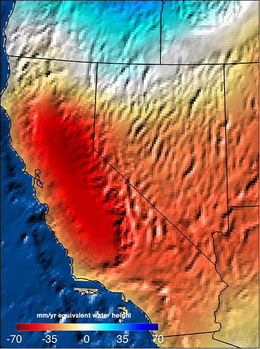
• Dec. 16, 2014: A study led by Jay Famiglietti of NASA's Jet Propulsion Laboratory (JPL) utilized data from the GRACE satellites to estimate the volume of water needed to recover from California's prolonged drought. The research, presented at the American Geophysical Union meeting in San Francisco, revealed that it would require roughly 1.5 times the maximum volume of the largest U.S. reservoir to mitigate the effects of California's ongoing drought. This calculation, a first of its kind, highlights the severity of the drought crisis. The GRACE satellite data showed that during the peak of California's three-year drought, the Sacramento and San Joaquin river basins had lost 11 trillion gallons of water, well below normal seasonal levels. Since 2011, these basins have been losing approximately four trillion gallons of water annually, equivalent to the domestic and municipal water usage of the state's 38 million residents. The depletion of groundwater in California's Central Valley accounted for around two-thirds of this loss. This data offers critical insights into the severe water shortage in California, emphasizing the importance of water management and conservation strategies in the face of prolonged drought conditions. 42) 43)
• October 2014: The GRACE mission has released 137 monthly gravity solutions, significantly enhancing our understanding of the Earth's climate system's various signals, including secular, seasonal, and inter-annual variations. This mission has been recognized for its contributions to climate science. However, several mission lifetime issues are being monitored. The altitude of the satellites is gradually decreasing, with estimates suggesting mission viability until around 2020. Propellant for attitude control is expected to be available until late 2016 or early 2017. The battery capacity is unpredictable, but the current strategy aims for operation until 2018. There are also considerations about operating the instruments in a single-string mode, which could affect the quality of science data. One notable achievement of the GRACE mission has been its contributions to oceanography, providing insights into various ocean phenomena across the globe. Additionally, GRACE data has played a role in studying Earth's surface temperature trends (Figure 23), contributing to our understanding of the Earth's energy balance and the role of the deep ocean in absorbing excess heat. 44) 45) 46)
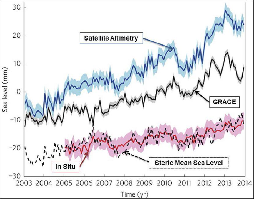
Legend to Figure 23: The estimates are observed variations by satellite altimetry, ocean mass contributions based on GRACE data, and steric sea level based on in situ observations. The dashed black curve shows the indirect steric mean sea-level estimate inferred by removing ocean mass contributions from the observed sea-level time series. Seasonal signals have been removed from all curves, and the curves are offset for clarity. Shaded blue, grey, and pink, where shown, denote one standard deviation of uncertainty in the respective estimates. The agreement between the red (in situ) line and the dashed black (steric mean sea level) curve indicates that the heat absorbed by the ocean is stored in the upper 2000 m of the ocean.
Hardware element (subsystem) | GRACE Satellite | Status |
Battery | GR1 | 18 of 20 cells (2 failed) |
ICU (Interface Control Unit) | GR1 | Single string |
IPU (Instrument Processing Unit) | GR1 | Backup unit may be operable |
OBDH (On-Board Data Handling) | GR1 | Fully redundant |
PCDU (Power Control Distribution Unit) | GR1 | Fully redundant |
SCA (Star Camera Assembly) | GR1 | Fully redundant |
TXR (RF communications) | GR1 | Fully redundant |
USO/MWA (Ultra Stable Oscillator(Microwave Assembly) | GR1 | Single string |
• September 2013: The GRACE operations status depends on the health of the battery and the duration within each orbit when the battery is in use. The mission has resumed full science data collection since UTC 07:50, Sept. 24 2013, after approximately 49 days of outage. The K-Band Ranging system was turned-on on both satellites at UTC 07:50, Sep 24 2013. The Accelerometers were turned on at UTC 10:35 Sept. 13 2013 (GRACE-1), and at UTC 08:33 Sept. 16, 2013 (GRACE-2). The GPS and star camera data has been collected continuously throughout. 47)
• June 2013: The 2013 Senior Review evaluated 13 NASA satellite missions in extended operations: ACRIMSAT, Aqua, Aura, CALIPSO, CloudSat, EO-1, GRACE, Jason-1, OSTM, QuikSCAT, SORCE, Terra, and TRMM. The Senior Review was tasked with reviewing proposals submitted by each mission team for extended operations and funding for FY14-FY15, and FY16-FY17. Since CloudSat, GRACE, QuikSCAT and SORCE have shown evidence of ageing issues, they received baseline funding for extension through 2015. 48)
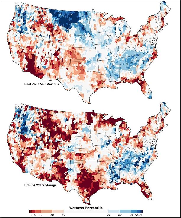
• June 2013: Figure 24 displays water storage maps of the United States using data from the GRACE mission and other sources, offering insights into changes in water storage related to weather, climate, and seasons as of June 3, 2013. In 2012, a severe drought affected nearly 80% of the nation's agricultural land. The top map illustrates short-term soil moisture conditions, revealing improvements in surface moisture in some areas but persistent dryness in others compared to the previous year. The bottom map depicts water storage in shallow aquifers, showing slow groundwater recovery in some regions while others experienced improvements. These maps underscore the vital role of GRACE data in understanding water availability and drought dynamics, especially in the face of changing climate conditions. 49) 50)
• November 2012: The GRACE operations status depends on the health of the battery and the duration within each orbit when the battery is in use. The GRACE mission has experienced battery degradation that requires careful electrical load and battery charging management. 51)
• March 17, 2012: The GRACE twin satellites have celebrated a decade in orbit, and their data have been instrumental in creating monthly gravity maps with unparalleled precision, over 100 times more accurate than earlier models. This breakthrough technology has significantly advanced the capabilities of scientists in various fields, including oceanography, hydrology, glaciology, geology, and climate science. GRACE's ability to measure the Earth's gravity field has not only exceeded expectations but has also emerged as a potent tool for climate research, enabling the observation of critical climate change indicators such as sea-level rise and polar ice melt. Recognizing the importance of extending this long-term dataset, NASA and DLR agreed to continue the mission through 2015 and approved the development and launch of the GRACE Follow-On mission in 2017.
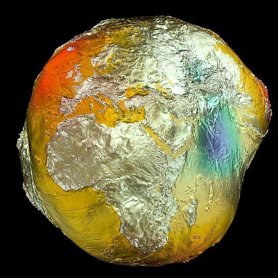
- Moreover, the unequal distribution of mass on and within the Earth, leading to variations in gravity, has shaped the planet into an irregular, non-spherical form known as the "Potsdam Gravity Potato." This unique shape is not static but subject to temporal changes. GRACE's capability to detect these changes, such as the ongoing effects of the last Ice Age, particularly in North America and Scandinavia, has further solidified its significance in scientific research. The improved resolution of GRACE's gravity maps is attributed to advancements in satellite measurements, including satellite gradiometry, satellite altimetry, and the long-term data provided by the GRACE mission itself. The latest gravity field model, EIGEN-6C, represents a remarkable achievement, incorporating data from sources like the GOCE satellite and the GFZ's GRACE mission. It's based on over 800 million observations and more than 75,000 parameters, resulting in a fourfold increase in spatial resolution compared to its predecessor. GOCE alone made 27,000 orbits during its operational period, collecting vital data on Earth's gravitational field variations. 55) 56) 58)
• March 21, 2012: The GRACE tandem constellation is operating nominally - completing its 10th year on orbit (March 17. 2012), which represents double the length of its design life. All instruments are providing measurements with regard to gravity determination and for the profiles of the weather services. — Since 2011, ESA is supporting the GRACE mission within the context of a TPM (Third Party Mission) arrangement. 59) 60)
• July 5, 2011: The GRACE tandem constellation is currently operating smoothly at an orbital altitude of approximately 455 km. The mission's science operations plan for the remaining mission duration is shaped by two primary factors. First, there is a project decision to operate the spacecraft in a manner that maximizes its remaining lifetime to ensure the longest possible climate data record from GRACE. Second, the mission faces challenges due to degraded battery capacity, which limits the availability of power during certain orbital configurations. The GRACE orbit plane precesses at a rate of approximately -1.117º per day relative to the Sun. This means that the Sun aligns with the orbit plane approximately every 161 days. Considering both the desire for mission longevity and the power system's condition, this 161-day event now serves as the basis for a work cycle in science operations. As long as the β' angle (the angle between the orbit plane and the Earth-Sun line) is greater than 69º, the satellite relies solely on power from its solar array. When the β' angle is smaller, the satellites use a combination of power from the arrays and power from the battery. During periods when β' is near zero (indicating that the Sun is in the orbit plane), the battery may be used for up to 40 minutes out of every 90 minutes in each orbit. The specific operations during events near β'=0 depend on the condition of the battery and the operational environment. 65)
• June 10, 2010: NASA and DLR signed an agreement during a bilateral meeting in Berlin, to extend the GRACE mission through the end of its on-orbit life, which is expected in the time frame 2013-2015, depending on solar activity, thruster actuation or battery status. GRACE's monthly maps are up to 100 times more accurate than existing maps, substantially improving the accuracy of techniques used by oceanographers, hydrologists, glaciologists, geologists and climate scientists.66) 67)
• February 2010: The GRACE tandem constellation is operating nominally in February 2010 (> 7 years in orbit). The lifetime of the GRACE mission is predicted through 2013. This would represent a total mission span of 11 years after launch, far exceeding its mission design and requirement. 68) 69)
• December 12, 2007: At the AGU fall meeting in San Francisco, NASA and the US Department of the Interior (DOI) presented the coveted William T. Pecora Award to the GRACE mission team.
• May 22, 2006: The GRACE mission activated routine collection of GPS atmospheric radio occultation data. GRACE-1 (trailing satellite) collects setting occultations. Only atmospheric occultation (50 Hz) data are being collected. Software is not able to collect ionospheric occultation (1 Hz) data.
• October 14, 2005: Following the GRACE Science Team Meeting in Austin, TX, NASA approved a mission extension through 2009. During this extended mission, significant achievements were made. Second-generation gravity models, such as GGM02 and EIGEN-CG03C, were developed and provided over 40 months of solutions. These advancements in gravity field determination had a profound impact on mass balance studies across various scientific disciplines, including hydrology, oceanography, glaciology, and solid Earth sciences. The analysis of GRACE data revealed that Earth's gravity field exhibits both spatial and temporal variability, serving as a crucial constraint on the mean and time-varying distribution of mass within the planet. Scientists leveraged these temporal variations to gain new insights into dynamic processes within the Earth's interior, the transfer of water masses over land and in oceans, and the behavior of ice sheets and glaciers in Greenland and Antarctica. GRACE's systematic monitoring of the movement of water, ice, and matter provided an unprecedented view of Earth's dynamic processes, revolutionizing our understanding of the planet. 71) 72)
Switch Maneuver of GRACE Satellites
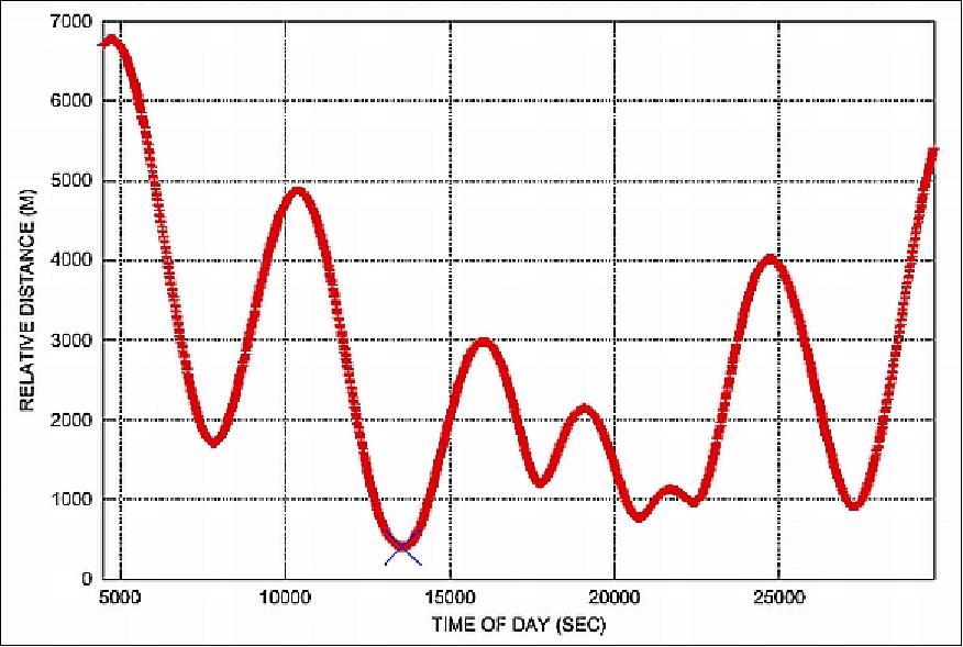
To ensure uniform aging and exposure of the K-band antennas on both GRACE satellites and minimize the risk of overexposure to atomic oxygen affecting the accuracy of the KBR signal, the GRACE team executed a satellite switch maneuver on December 10, 2005. This maneuver was carefully planned to avoid a collision, ensuring that the two satellites never got closer than 406 meters at their closest approach. The switch was accomplished successfully with only three Orbit Thrust Maneuvers (OTMs), with the trailing satellite (GRACE-2) becoming the leading satellite by January 2006, as illustrated in Figures 26 and 27. 73) 74)
Date | Event | GRACE-2 | GRACE-1 | Range (km) |
Dec. 3 2005 | OTM-1 | Yaw 180º (yaw bias=180º) |
| -203 |
Dec. 9 |
| Yaw 180º (yaw bias=180º) for KBR, receiver safety (link breaks) |
| -29 |
Dec. 10 | Closest approach (CA) | CA at ~04:00 UTC; GRACE-2 passes GRACE-1 and becomes the leader |
| 0 |
Dec. 11 |
|
| Yaw 180º (yaw bias=0); re-establish KBR link | 29 |
Dec. 12 | OTM-2 | Yaw 180º (yaw bias=0º) |
| 58 (3.3 km/day) |
Jan. 11, 2006 | OTM-3 | Yaw 180º (yaw bias=0º) |
| 170 (0.5 km/day) |
Sensor Complement
GRACE does not carry a suite of independent scientific instruments. Instead, the twin GRACE satellites act in unison as the primary science instrument. The K-band ranging system (KBR) can detect instantaneous extremely small changes in the distance between the two satellites and use this information to make gravitational measurements with a level of precision never before possible.
The "science instruments" are mounted on a CFRP (Carbon Fiber Reinforced Plastic) bench in the S/C interior, as are the fuel tanks and the batteries and other satellite subsystems.
SIS (Science Instrument System)
The SIS includes all elements of the inter-satellite ranging system, the GPS receivers required for precision orbit determination and occultation experiments, and associated sensors such as SCA. SIS also coordinates the integration activities of all sensors, assuring their compatibility with each other and the satellite. 75)
KBR (K/Ka-Band Ranging) Instrument Assembly of NASA/JPL
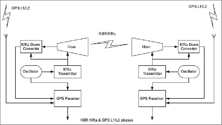
KBR is the key science instrument of the GRACE mission [Note: KBR is also referred to as HAIRS (High Accuracy Intersatellite Ranging System)]. The objective is ultra-precise satellite-to-satellite tracking (SST) in low-low orbit. The measurement method employed is referred to as DOWR (Dual One Way Ranging). In this approach, each of the two satellites transmits a carrier signal and measures the phase of the carrier generated by the other satellite relative to the signal it is transmitting. The sum of the phases generated is proportional to the range change between the satellites, while the phase variation due to long-term instability in each clock cancels out. 76)
K-band has a radio frequency of about 24 GHz and Ka-band is near 32 GHz. The GRACE K- and Ka-band frequencies are in an exact 3-to-4 ratio on each satellite. The KBR system can measure the range (with a bias) to the µm level.
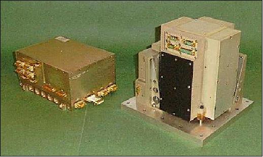
Variations in the gravity field cause the range between the two satellites to vary. The relative range is measured by KBR (a microwave link which is integrated with a GPS receiver). The measured range variations are corrected for non-gravitational effects by an accelerometer called SuperSTAR. KBR consists of the following elements: USO (Ultra Stable Oscillator), the MWA (Microwave Assembly), the horn, and IPU (Instrument Processing Unit). The IPU and the SPU (Signal Processing Unit) constitute the heart of the instrument system. 77) 78)
Legend to Figure 28: The IPU, SPU, KBR and ACC are internally redundant, and the ultra-stable oscillator (USO) is redundant.
USO (of JHU/APL) serves as the frequency reference. The microwave assembly, or sampler, is used for up-converting the reference frequency to 24 and 32 GHz; down-converting the received phase from the other satellite; and for amplifying and mixing the received and the reference carrier phase. The horn is used to transmit and receive the carrier phase between the satellites.
- The IPU is used for sampling and digital signal processing of not only the K-Band carrier phase signal, but also the signals received by the GPS antenna and the star cameras. Each satellite transmits carrier phase to the other at two frequencies, allowing for ionospheric corrections. The transmit and receive frequencies are offset from each other by 0.5 MHz in the 24 GHz channel, and by 0.67 MHz in the 32 GHz channel. This shifts the down-converted signal away from DC, enabling more accurate measurements of the phase. The 10 Hz samples of phase change at the two frequencies are downlinked from each satellite, where the appropriately decimated linear combination of the sum of the phase measurements at each frequency gives an ionosphere-corrected measurement of the range change between the satellites.
SuperSTAR (Super Space Three-axis Accelerometer for Research mission)
SuperSTAR is an accelerometer developed by ONERA/CNES, France (of STAR heritage on CHAMP, with a resolution a factor 10 higher than that on CHAMP). 80) The objective of SuperSTAR is the measurement of all non-gravitational accelerations (drag, solar and Earth radiation pressure) acting on the GRACE spacecraft. The measurement principle of the SuperSTAR accelerometer is based on the electrostatic suspension of a parallel-epipedic proof mass inside a cage. The cage walls are equipped with control electrodes which serve both as capacitive sensors to derive the instantaneous proof mass (PM) position and as actuators to apply electrostatic forces in order to keep the PM motionless in the center of the cage.
The configuration of the two SuperSTAR accelerometers is quasi-identical to STAR and takes advantage of the CHAMP mission experience.
The improvement of the performances with respect to STAR comes mainly from the increased gap between the proof-mass and the sensitive axes electrodes: 175 µm instead of 75 µm in the CHAMP model and also of the modification of electronics function parameters as for example le reduction of the bias reference voltage by a factor 2, a better adjustment of the measurement conditioning amplifiers and an optimized exploitation of the 24-bit sigma-delta analogue to digital converters. 81)
SuperSTAR is mounted at the CG (Center of Gravity) of the satellite. SuperSTAR consists of the following elements: SU (Sensor Unit, EEU (Electromagnetic Exciting Unit), ICU (Interface Control Unit), and a harness. SU consists of a metallic proof mass, suspended inside an electrode cage of gold-coated silica. The proof mass motion is servo-controlled using capacitive sensors, and is a measure of the non-gravitational accelerations acting on the satellite. The mass and electrode cage core is enclosed by a sole plate and a housing in which vacuum is maintained using a getter. The SU vacuum unit is surrounded by analog electronics. The EEU is used to deliver a 10 mg acceleration, and is used only in case of an SU start-up problem. The ICU supplies power to the SU and EEU, and operates the accelerometer through a micro-controller board.
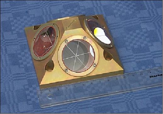
SCA (Star Camera Assembly)
SCA is of CHAMP heritage. The objective is the precise measurement of satellite attitude. SCA consists actually of two DTU (Technical University of Denmark) star camera assemblies (2 cameras with sensor heads), each with a FOV of 18º x 16º and one DPU (Data Processing Unit). Both assemblies are rigidly attached to the accelerometer, and view the sky at a 45º angle with respect to the zenith, on the port and starboard sides. The SCA is used for both: science as well as AOCS; the two assemblies provide the primary precise attitude determination for each satellite. The baffles are used to avoid the degradation due to solar heating. SCA measures the S/C attitude to an accuracy of < 0.3 mrad (with a goal of 0.1 mrad) by autonomous detection of star constellations using an onboard star catalog.

LRA (Laser Corner-cube Reflector Assembly)
LRA is provided by GFZ (also referred to as LRR (Laser Retro-Reflector). LRA is mounted on the underside of the spacecraft to permit orbit verification from terrestrial laser tracking networks. The direct distance can be measured with an accuracy of 1-2 cm (depending on the technological status of the measuring ground station). The LRA data are being used for:
• POD (Precise Orbit Determination) in combination with GPS tracking data for gravity field recovery
• Calibration of the onboard GPS space receiver (BlackJack)
• Technology experiments such as two-color ranging (this involves differential ranging to eliminate tropospheric signal effects).
BlackJack (GPS Flight Receiver)
BlackJack is a new generation instrument of TRSR (TurboRogue Space Receiver) heritage, provided by JPL (see description under CHAMP). The objective is to use the GPS instrument for navigation (precise orbit determination) and radio-occultation (refractive occultation monitoring) applications. BlackJack features three antennas, the main zenith crossed dipole antenna is used to collect the navigation data. In addition, a backup crossed dipole antenna and one helix antenna on the aft panel are used for back-up navigation and atmospheric occultation data collection, respectively. This system is capable of simultaneously tracking up to 24 dual frequency signals. In addition, this system provides digital signal processing functions for the KBR and SCA instruments as well.

References
1) C. W. Hughes, C. Wunsch, V. Zlotnicki, "Satellite Peers through the Oceans from Space," EOS Transmissions of AGU, Vol. 81, No. 7, Feb. 15, 2000, p. 68
2) https://web.archive.org/web/20240614124946/https://www2.csr.utexas.edu/grace/
3) "A new name for the GFZ: Helmholtz Centre Potsdam – GFZ German Research Centre for Geosciences," Helmholtz Association, June 17, 2008, URL: http://www.helmholtz.de/en/news/press_and_
news/press_archive/artikel/artikeldetail/a_new
_name_for_the_gfz_helmholtz_centre_potsdam_gfz_german_
research_centre_for_geosciences/
4) J. Herman, D. Presti, A. Codazzi, C. Belle, "Attitude Control for GRACE: The First Low-Flying Satellite Formation," 18th International Symposium on Space Flight Dynamics, Munich, Germany, Oct. 11-15, 2004
5) Byron Tapley, Sandra Zaragoza, Carol Rasmussen,"GRACE — Gravity Recovery and Climate Experiment," NASA, March 2, 2011, URL: http://solarsystem.nasa.gov/scitech/display.cfm?ST_ID=186
6) "NASA's GRACE: What We've Learned from Water in Motion," NASA/JPL News, 13 May 2019, URL: https://www.jpl.nasa.gov/news/news.php?release=2019-087
7) "What Earth's gravity reveals about climate change," GFZ News, 16 April 2019, URL: https://www.gfz-potsdam.de/en/media-and-communication/news/
details/article/what-earths-gravity-reveals-about-climate-change/
8) Byron D. Tapley, Michael M. Watkins, Frank Flechtner, Christoph Reigber, Srinivas Bettadpur, Matthew Rodell, Ingo Sasgen, James S. Famiglietti, Felix W. Landerer, Don P. Chambers, John T. Reager, Alex S. Gardner, Himanshu Save, Erik R. Ivins, Sean C. Swenson, Carmen Boening, Christoph Dahle, David N. Wiese, Henryk Dobslaw, Mark E. Tamisiea & Isabella Velicogna, "Contributions of GRACE to understanding climate change," Nature Climate Change, Published: 15 April 2019, https://doi.org/10.1038/s41558-019-0456-2
9) "NASA Satellites Reveal Major Shifts in Global Freshwater," NASA Release 18-008, 16 May 2018, URL: https://www.nasa.gov/press-release/nasa-satellites
-reveal-major-shifts-in-global-freshwater
10) M. Rodell, J. S. Famiglietti, D. N. Wiese, J. T. Reager, H. K. Beaudoing, F. W. Landerer, M.-H. Lo, "Emerging trends in global freshwater availability," Nature, Published: 16 May 2018, doi:10.1038/s41586-018-0123-1, URL: https://www.nature.com/articles/s41586-018-0123-1
11) "Re-Entry: GRACE 1," Spaceflight 101, 11 March 2018, URL: https://web.archive.org/web/20240522045403/https://spaceflight101.com/re-entry-grace-1/
12) Alan Buis, Carol Rusmussen, "Wet Winters May Not Dampen Small Wildfires," NASA GRACE mission, 21 Dec. 2017, URL: [web source no longer available]
13) Daniel Jensen, John Reager, Brittany Zajic, Nick Rousseau, Matthew Rodell, Everett Hinkley, "The sensitivity of US wildfire occurrence to pre-season soil moisture conditions across ecosystems," Environmental Research Letters, Accepted Manuscript online 6 November 2017, in press, https://doi.org/10.1088/1748-9326/aa9853 URL: http://iopscience.iop.org/article/10.1088/1748-9326/aa9853/pdf
14) "Prolific Earth Gravity Satellites End Science Mission," NASA Release 17-084, 27 Oct. 2017, URL: https://www.jpl.nasa.gov/news/news.php?feature=6984&utm_
source=iContact&utm_medium=email&utm_campaign=NASA
JPL&utm_content=daily20171027-1
15) "GRACE mission comes to an end after 15 years of successful operation," DLR, 27 October 2017, URL: http://www.dlr.de/dlr/en/desktopdefault.aspx/tabid-
10081/151_read-24627/year-all/#/gallery/28808
16) "Groundwater Gains in India," NASA Earth Observatory, 22 Sept. 2017, URL: https://earthobservatory.nasa.gov/IOTD/view.php?id=91008&src=iotdrss
17) Soumendra N. Bhanja, Abhijit Mukherjee, Matthew Rodell, Yoshihide Wada, Siddhartha Chattopadhyay, Isabella Velicogna, Kishore Pangaluru, James S. Famiglietti, "Groundwater rejuvenation in parts of India influenced by water-policy change implementation," Scientific Reports, Vol. 7, Article No 7453, published online: 7 August 2017, doi:10.1038/s41598-017-07058-2, URL: https://www.nature.com/articles/s41598-017-07058-2#Fig1
18) "GRACE Making Plans for Final Science Data Collection,"NASA, Sept. 14, 2017, URL: [web source no longer available]
19) Alan Buis, "GRACE Mission: 15 Years of Watching Water on Earth," NASA/JPL, Feature 2017-070, March 15, 2017, URL: https://grace.jpl.nasa.gov/news/89/grace-mission-15-years-of-watching-water-on-earth/
20) "GRACE Mission Status Update," UTA/CSR, Dec. 8, 2016, URL: https://web.archive.org/web/20240801085408/https://www2.csr.utexas.edu/grace/
21) Byron Tapley, Frank Flechtner, Carmen Boening, Srinivas Bettadpur, "GRACE Mission: Status and Prospects," Proceedings of the GSTM 2016, Potsdam, Germany, October 5-7, 2017, URL: http://www.gfz-potsdam.de/en/section/global-geomonitoring-and-gravity-field/topics/development-
operation-and-analysis-of-gravity-field
-satellite-missions/grace/gstm/gstm-2016/proceedings/
22) Stephen Clark, "Iridium to share Falcon 9 launch with NASA-German gravity satellites," Spaceflight Now, Feb. 6, 2017, URL: https://spaceflightnow.com/2017/02/06/iridium-to-
share-falcon-9-launch-with-nasa-german-gravity-satellites/
23) Carmen Boening," 2016 GRACE Science Team Meeting Summary," The Earth Observer, January - February 2017. Volume 29, Issue 1, pp: 40-42, URL: https://eospso.nasa.gov/sites/default/files/eo
_pdfs/Jan-Feb%202017%20color%20508.pdf
24) Alan Buis, Carol Rasmussen, "NASA Study Solves Two Mysteries About Wobbling Earth," NASA/JPL News, April 8, 2016, URL: http://www.jpl.nasa.gov/news/news.php?release=2016-100
25) Surendra Adhikari, Erik R. Ivins, "Climate-driven polar motion: 2003-2015," Science Advances, April 8, 2016, Vol. 2, No 4, e1501693, DOI: 10.1126/sciadv..1501693, URL: http://advances.sciencemag.org/content/2/4/e1501693.full
26) Shannon Hall, "Earth Is Tipping Because of Climate Change - Melting ice and shifting rain patterns are causing the north and south poles to drift," Scientific American, April 8, 2016, URL: http://www.scientificamerican.com/article/earth-is-tipping-because-of-climate-change1/
27) Steve Platnick, "Editor's Corner," NASA, The Earth Observer. March - April 2016. Volume 28, Issue 2, p. 2, URL: http://eospso.nasa.gov/sites/default/files/eo_pdfs/Mar_Apr_2016_508_color.pdf
28) Alan Buis, Faisal Hossain, Jenifer Langston, "NASA data used to track groundwater in Pakistan," NASA, Feb. 29, 2016, URL: http://climate.nasa.gov/news/2407/
29) Charles Day, "Weighing Brazil's drought from space - A pair of gravity-sensing spacecraft are tracking changes in the country's water," Physics Today, Dec. 3, 2015, URL: http://scitation.aip.org/content/aip/magazine/physicstoday/
news/10.1063/PT.5.7224;jsessionid=b8d93elq1bdn1.x-aip-live-06
30) "Mission Operations Status (Updated: 2015-Nov-09)," URL: https://www2.csr.utexas.edu/grace/operations/
31) Alan Buis, Carol Rasmussen, "NASA Finds New Way to Track Ocean Currents from Space," NASA/JPL, Nov. 2, 2015, URL: http://www.jpl.nasa.gov/news/news.php?feature=4761&u
tm_source=iContact&utm_medium=email&utm_c
mpaign=NASAJPL&utm_content=weekly20151106-4
32) Felix W. Landerer, David N. Wiese, Katrin Bentel, Carmen Boening, Michael M. Watkins, "North Atlantic meridional overturning circulation variations from GRACE ocean bottom pressure anomalies," Geophysical Research Letters, Volume 42, Issue 19, 16 October 2015, pp: 8114–8121, DOI: 10.1002/2015GL065730
33) Matt Rodell, Bailing Li, Sujay Kumar, Hiroko Beaudoing, Ben Zaitchik, James Famiglietti, "Observing Water Cycle Extremes with GRACE," Earth Observation for Water Cycle Science 2015, Frascati, Italy, 20-23 October, 2015, URL: http://congrexprojects.com/custom/15C10/D2_0925_Magellan_Rodell.pdf
34) Byron Tapley, Frank Flechtner, Michael Watkins, Srinivas Bettadpur, "GRACE Mission: Status and Prospects," GRACE Science Team Meeting, Austin Texas, USA, Sept. 21-23,2015, URL: https://www2.csr.utexas.edu/grace/GSTM/2015/proceedings.html
35) Mona Witkowski, Franz-Heinrich Massmann, "Status GRACE Mission Operations," GRACE Science Team Meeting, Austin Texas, USA, Sept. 21-23,2015, URL: https://web.archive.org/web/20240418052222/https://www2.csr.utexas.edu/grace/operations/mission_status/
36) "NASA Earth Science Senior Review 2015 submitted to Michael Freilich," June 22, 2015, URL: http://science.nasa.gov/media/medialibrary
/2015/07/15/2015_ESDSeniorReviewReport_FINAL.pdf
37) "A third of the world's biggest groundwater basins are in distress," UCI News, June 16, 2015, URL: http://news.uci.edu/press-releases/a-third-of-the
-worlds-biggest-groundwater-basins-are-in-distress/
38) Alexandra S. Richey, Brian F. Thomas, Min-Hui Lo, James S. Famiglietti, Sean Swenson, Mathhew Rodell, "Uncertainty in global groundwater storage estimates in a total groundwater stress framework," Water Resources Research, June 16, 2015, doi: 10.1002/2015WR017351
39) "Mission Operations Status (Updated: 2015-May-13)," UTA/CRS, May 13, 2015, URL: https://www2.csr.utexas.edu/grace/operations/mission_status/
40) "GRACE operational issue: Planned switch-on of Microwave Assemblies," ESA, January 19, 2015, URL: https://web.archive.org/web/20190117094835/https://earth.esa.int/web/guest/missions/mission-news/-/article/grace-operational-issue-planned-switch-on-of-microwave-assemblies-jan-2015
41) "Mission Operations Status (Updated: 2015-Jan-14)," UTA/CRS, Jan. 15, 2015, URL: https://web.archive.org/web/20230605060552/http://www.csr.utexas.edu/grace/GSTM/2015/proceedings.html
42) Steve Cole, Alan Buis, "NASA Analysis: 11 Trillion Gallons to Replenish California Drought Losses," NASA, Release 14-333, Dec. 16, 2014, URL: http://www.nasa.gov/press/2014/december/nasa-analysis
-11-trillion-gallons-to-replenish-california-drought-losses/#.VNMmRi7-Y_d
43) Steve Cole, Alan Buis, Janet Wilson, "Satellite Study Reveals Parched U.S. West Using Up Underground Water," NASA, Release 14- 200, July 24, 2014, URL: http://www.nasa.gov/press/2014/july/satellite-study-reveals-parched-us-west-using-up-underground-water/#.VNMtES7-Y_c
44) Byron Tapley, Frank Flechtner, Michael Watkins, Srinivars Bettapur, "GRACE Mission: Status and Prospects," Proceedings of the GSTM (GRACE Science Team Meeting), Potsdam, Germany, Sept. 29-Oct. 1, 2014, URL: https://media.gfz-potsdam.de/gfz/sec12/GSTM-2014/GSTM2014-A0.zip
45) Mona Witkowski, Franz-Heinrich Massmann, "Status GRACE Mission Operations," Proceedings of the GSTM (GRACE Science Team Meeting), Potsdam, Germany, Sept. 29-Oct. 2, 2014, URL: https://media.gfz-potsdam.de/gfz/sec12/GSTM-2014/GSTM2014-A0.zip
46) Carmen Boeing, Michael M. Watkins, Felix W. Landerer, Isabella Velicogna, Victor Zlotnicki, Margaret Srinivasan, "2014 GRACE Science Team Meeting," The Earth Observer, May-June 2015, Volume 27, Issue 3, pp:24-27, URL: http://eospso.nasa.gov/sites/default/files/eo_pdfs/May_Jun_2015_color_508.pdf
47) "Mission Operations Status (Updated: 2013-Sept-25)," CSR at the University of Texas, Austin, URL: https://web.archive.org/web/20110525202858/http://www.csr.utexas.edu/grace/operations/mission_status/
48) Elizabeth Ritchie (Chair), Ana Barros, Robin Bell, Alexander Braun, Richard Houghton, B. Carol Johnson, Guosheng Liu, Johnny Luo, Jeff Morrill, Derek Posselt, Scott Powell, William Randel, Ted Strub, Douglas Vandemark, "NASA Earth Science Senior Review 2013," June 14, 2013, URL: http://science.nasa.gov/media/medialibrary/20
13/07/16/2013-NASA-ESSR-FINAL.pdf
49) "Water Storage Maps Show Improvement," NASA Earth Observatory, June 18, 2013, URL: http://earthobservatory.nasa.gov/IOTD/view.php?id=81408
50) Holli Riebeek, Robert Simmon, "The Gravity of Water - The GRACE mission offers a novel and much needed view of Earth's water supplies," NASA Earth Observatory, Sept. 12, 2012, URL: http://earthobservatory.nasa.gov/Features/GRACEGroundwater/
51) "Mission Operations Status (Updated: 2012-Nov-19)," CSR/UTexas, URL: https://web.archive.org/web/20110525202858/http://www.csr.utexas.edu/grace/operations/mission_status/
52) Don P. Chambers, John Wahr, Mark E. Tamisiea, R. Steven Nerem, "Ocean mass from GRACE and glacial isostatic adjustment," Journal of Geophysical Research-Solid Earth, Vol. 115, 2010, B11415, doi:10.1029/2010JB007530
53) R. S. Nerem, D. P. Chambers, M. Merrifield, G. Mitchum, D. Masters, "A 20 Year Climate Data Record of Sea Level Change: What have we learned?" Proceedings of the Symposium '20 years of Progress in Radar Altimetry', Venice, Italy, Sept. 24-29, 2012, (ESA SP-710, Feb. 2013)
54) Jaap Herman, Michael Steinhoff, "Balancing, Turning, Saving - Special AOCS Operations to extend the GRACE Mission," Proceedings of SpaceOps 2012, The 12th International Conference on Space Operations, Stockholm, Sweden, June 11-15, 2012
55) Alan Buis, "At 10, GRACE Continues Defying, and Defining, Gravity," NASA, March 16, 2012, URL: http://www.nasa.gov/mission_pages/Grace/news/grace20120316.html
56) "Gravity is climate: Ten Years of climate research satellites GRACE," GFZ Press Release, March 17, 2012, URL: http://www.sciencedaily.com/releases/2012/03/120316195351.htm
57) "Geoid: The Potsdam Gravity Potato," URL: http://www.gfz-potsdam.de/en/media-communication/mediathek/
image-galleries/geoid-the-potsdam-gravity-potato/
58) Matt Williams, "The "Potsdam Gravity Potato" Shows Variations in Earth's Gravity," Universe Today, Nov. 29, 2014, URL: http://www.universetoday.com/116801/the-potsdam-gravity
-potato-shows-earths-gravity-variations/
59) Information provided by Franz-Heinrich Massmann of GFZ Potsdam, Germany
60) "'Gravity is climate' - 10 years of climate research satellites GRACE," Space Daily, March 21, 2012, URL: http://www.spacedaily.com/reports/Gravity_is_climate_10_years
_of_climate_research_satellites_GRACE_999.html
61) "Mission Operations Status (Updated: Jan. 19, 2012)," UTA/CSR, URL: https://web.archive.org/web/20110525202858/http://www.csr.utexas.edu/grace/operations/mission_status/
62) J. Herman, A. Davis, K. B. Chin, M. Kinzler, S. Scholz, M. Steinhoff, "Life with a weak Heart - Prolonging the Grace Mission despite degraded Batteries," Proceedings of SpaceOps 2012, The 12th International Conference on Space Operations, Stockholm, Sweden, June 11-15, 2012
63) George Hurtt (Chair), Ana Barros, Richard Bevilacqua, Mark Bourassa, Jennifer Comstock, Peter Cornillon, Andrew Dessler, Gary Egbert, Hans-Peter Marshall, Richard Miller, Liz Ritchie, Phil Townsend, Susan Ustin,"NASA Earth Science Senior Review 2011," June 30, 2011, URL: http://science.nasa.gov/media/medialibrary/2011/07/2
2/2011-NASA-ESSR-v3-CY-CleanCopy_3x.pdf
64) "Operations," URL: https://web.archive.org/web/20230406203004/http://www.csr.utexas.edu/grace/operations/
65) "Mission Operations Status (Updated: 2011-July-5)," UTA/CSR , URL: https://web.archive.org/web/20110525202858/http://www.csr.utexas.edu/grace/operations/mission_status/
66) "NASA and DLR Sign Agreement to continue GRACE Mission through 2015," June 10, 2010, URL: http://www.dlr.de/en/desktopdefault.aspx/tabid-6604/10829_read-24882/
67) "NASA And DLR To Continue Grace Mission Through 2015," Space Daily, June 11, 2010, URL: http://www.spacedaily.com/reports/NASA_And_DLR_To
_Continue_Grace_Mission_Through_2015_999.html
68) Byron D. Tapley, Markus Rothacher, Srinivas Bettapur, Frank Flechtner, Michael Watkins, "The GRACE Mission: Status and Future Prospects," 37th COSPAR Scientific Assembly, July 13-20, 2008, Montréal, Canada.
69) S. Bettadpur, B. Tapley, C. Reigber, "GRACE Status and Future Plans," 3rd International GOCE User Workshop, Nov. 6-8, 2006, ESA/ESRIN, Frascati, Italy, URL: http://earth.esa.int/workshops/goce06/participants/315/pres_tapley_315.pdf
70) Steven A. Ackerman (chair), Richard Bevilacqua, Bill Brune, Bill Gail, Dennis Hartmann, George Hurtt, Linwood Jones, Barry Gross, John Kimball, Liz Ritchie, CK Shum, Beata Csatho, William Rose, Carlos Del Castillo, Cheryl Yuhas, "NASA Earth Science Senior Review 2009," URL: http://nasascience.nasa.gov/about-us/science-strategy/senior
-reviews/2009SeniorReviewSciencePanelReportFINAL.pdf
71) S. Bettadpur, "GRACE Science Team Meeting," (Oct. 13-14, 2005, Austin, TX), The Earth Observer, Nov.-Dec. 2005, Vol. 17, Issue 6, pp. 22-23
72) J. Ries, D. Chambers, S. Bettadpur, B. Tapley, "GRACE Mission Status and Current Results," Ocean Topography Science Team Meeting, Vienna, Austria, April 16-18, 2006
73) "Switch Maneuver Of GRACE Satellites," URL: https://www2.csr.utexas.edu/grace/operations/switch_maneuver.html
74) P. A. M. Abusali, S. Bettadpur, "Switch Maneuver of GRACE Satellites," The Earth Observer (NASA/GSFC), March-April 2006, Vol. 18, Issue 2, pp. 4-5
75) "Science Instrument System (SIS)," GFZ, URL: http://www.gfz-potsdam.de/en/section/globalgeomonitoringandgravity
field/topics/development-operation-and-analysis-of-gravity
-field-satellite-missions/grace-fo/instruments/
76) Charles Dunn, Willy Bertiger, Yoaz Bar-Sever, Shailen Desai, Bruce Haines, Da Kuang, Garth Franklin, Ian Harris, Gerhard Kruizinga, Tom Meehan, Sumita Nandi, Don Nguyen, Tim Rogstad, J. Brooks Thomas, Jeff Tien, Larry Romans, Michael Watkins, Sien-Chong Wu, Srinivas Bettadpur, Jeongrae Kim, "Instrument of Grace," GPS World, March 25, 2003, URL: https://www2.csr.utexas.edu/grace/publications/press/03-02-01-GRACE_gpsworld.pdf
77) Charles Dunn, Willy Bertiger, Garth Franklin, Ian Harris, Gerhard Kruizinga, Tom Meehan, Sumita Nandi, Don Nguyen, Tim Rogstad, J. Brooks Thomas, Jeff Tien, "The Instrument on NASA's GRACE Mission: Augmentation of GPS to Achieve Unprecedented Gravity Field Measurements," ION-GPS 2002, Portland, OR, Sept. 24-27, 2002, URL of presentation: https://web.archive.org/web/20160508060714/http://trs-new.jpl.nasa.gov/dspace/bitstream/2014/10486/1/02-2484.pdf
78) W. Bertiger, Y. Bar-Sever, S. Desai, C. Dunn, B. Haines, D. Kuang, S. Nandi, L. Romans, M. Watkins, S. Wu, "GRACE: Millimeters and Microns in Orbit," ION-GPS 2002, Portland, OR, Sept. 24-27, 2002
79) Jeongrae Kim, Seung Woo Lee, "Flight performance analysis of GRACE K-band ranging instrument with simulation data," Acta Astronautica, Vol. 65, 2009, pp. 1571-1581
80) Note: STAR and SuperSTAR are of ASTRE (Accéléromètre Spatial Triaxial Electrostatique) heritage, built by ONERA. ASTRE was part of the ESA Microgravity Measurement Assembly (MMA), and flown on STS-55 (Apr. 26 - May 6, 1993), STS-83 (Apr. 4-8, 1997) and on STS-94 (Jul. 1-17, 1997)
81) Bernard Foulon, Bruno Christophe, Yannick Bidel, "Two Decades of electrostatic accelerometers for space geodesy: past or future?," Proceedings of IAC 2011 (62nd International Astronautical Congress), Cape Town, South Africa, Oct. 3-7, 2011, paper: IAC-11-B1.3.4
Spacecraft Launch Mission Status Sensor Complement References Back to Top