HARP (Hyper-Angular Rainbow Polarimeter)
EO
Cloud profile and rain radars
Atmosphere
Cloud type, amount and cloud top temperature
Quick facts
Overview
| Mission type | EO |
| Agency | UMBC |
| Mission status | Mission complete |
| Launch date | 02 Nov 2019 |
| End of life date | 22 Apr 2022 |
| Measurement domain | Atmosphere |
| Measurement category | Cloud type, amount and cloud top temperature, Atmospheric Temperature Fields, Cloud particle properties and profile, Aerosols, Atmospheric Humidity Fields, Atmospheric Winds |
| Measurement detailed | Cloud top height, Aerosol absorption optical depth (column/profile), Cloud optical depth, Cloud liquid water (column/profile), Cloud top temperature, Atmospheric stability index, Cloud mask, Cloud top pressure |
| Instrument type | Cloud profile and rain radars, Atmospheric chemistry, Data collection, Atmospheric temperature and humidity sounders |
| CEOS EO Handbook | See HARP (Hyper-Angular Rainbow Polarimeter) summary |
Related Resources
HARP (Hyper-Angular Rainbow Polarimeter)
Spacecraft Launch Mission Status Sensor Complement References
HARP is a NASA/ESTO (Earth Science Technology Office) funded CubeSat mission under the InVEST (In-Space Validation of Earth Science Technologies) Program. The HARP CubeSat mission is a joint effort between the UMBC (University of Maryland Baltimore County), Catonsville, MD, USU/SDL (Utah State University/Space Dynamics Laboratory ), North Logan, UT, STC (Science and Technology Corporation) with HQ in Hampton, VA, and NASA/GSFC (Goddard Space Flight Center) in Greenbelt, MD. The goal is to deploy the HARP CubeSat from the ISS. The desired mission life consists of three months for technology demonstration and an extended science data period of another seven months, which will total almost a year on orbit.
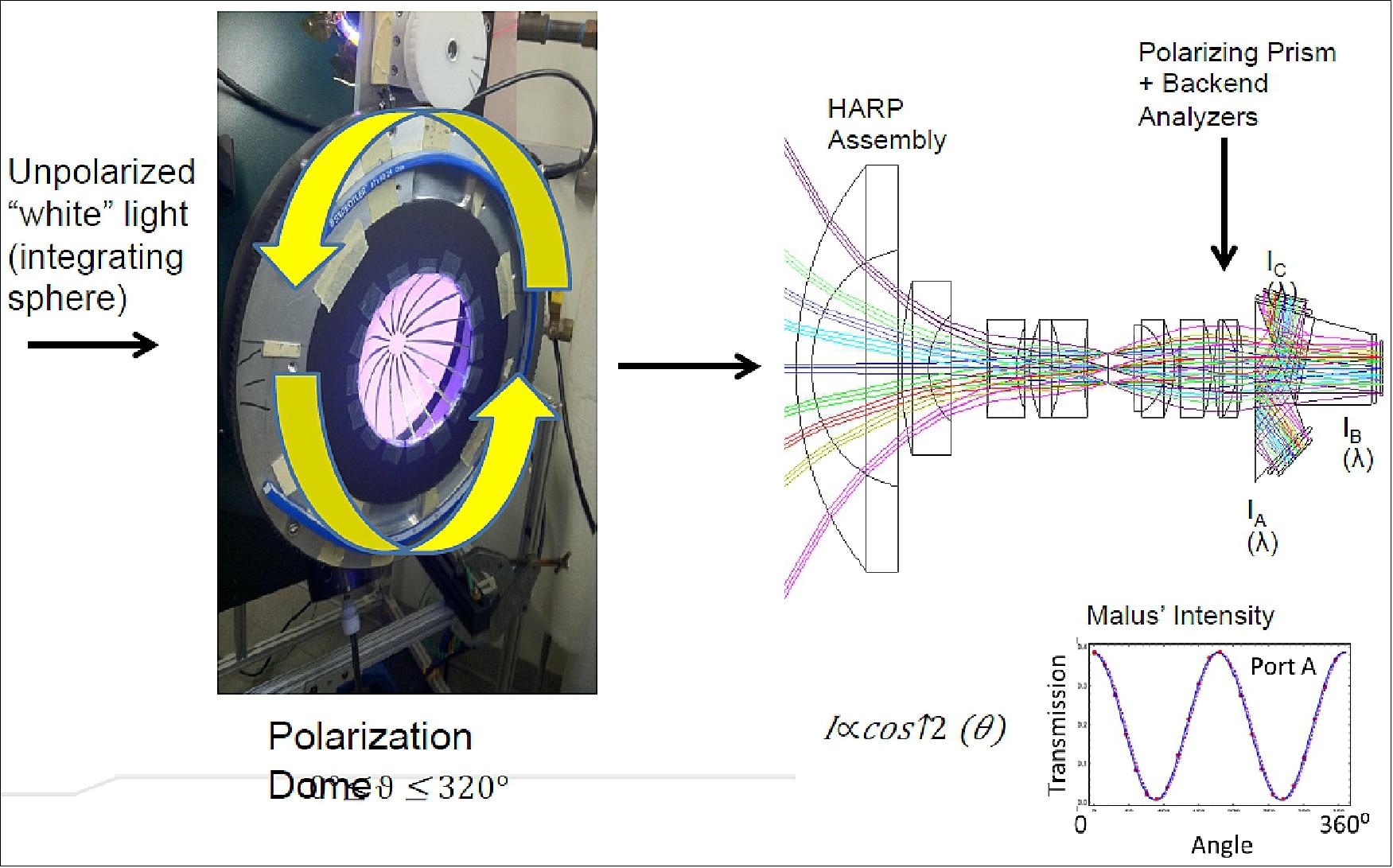
The HARP mission is designed to measure the microphysical properties of cloud water and ice particles in the atmosphere. HARP is a precursor for the new generation of imaging polarimeters to be used for the detailed measurements of aerosol and cloud properties. The HARP payload is a wide FOV (Field of View) imager that splits three spatially identical images into three independent polarizers and detector arrays. This technique achieves simultaneous imagery of three polarization states and is the key innovation to achieve high polarimetric accuracy with no moving parts.
The objectives of the HARP demonstration mission are: 1) 2)
• Validate the in-flight capabilities of a highly accurate and precise wide field of view hyper-angular polarimeter for characterizing aerosol and cloud properties.
• Prove that CubeSat technology can provide science-quality multi angle imaging data paving the way for lower cost aerosol-cloud instrument developments.
• Provide opportunities for student research and engineering training in implementing a space mission.
The HARP science goal is to demonstrate the ability to characterize the micro physical properties of aerosols and clouds at the scale of individual moderate-sized clouds for the ultimate purpose of narrowing uncertainties in climate change.
The PI (Principal Investigator) of the HARP mission is J. Vanderlei Martins of UMBC. The Co-Is/Partners are: Lorraine Remer, JCET-UMBC; Tim Nielsen, USU/SDL; Leroy Sparr, NASA/GSFC; Mark Schoeberl, STC. 3)
HARP is a potential precursor for the polarimeter in ACE (Aerosol-Clouds and Echosystems) and other future NASA missions.
Spacecraft
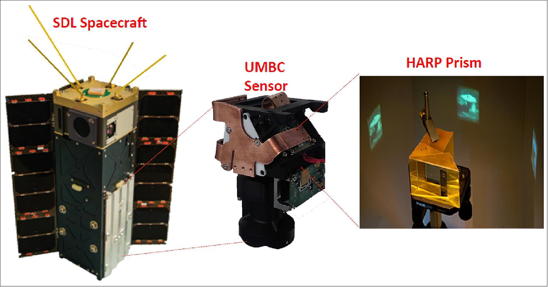
The HARP CubeSat mission will be a joint effort between UMBC, the PI institution, who will provide the instrument and characterization and scientific analysis; the Space Dynamics Laboratory – Utah State University, who will provide the 3U CubeSat spacecraft and mission operations; and the Science and Technology Corporation, who will lead the science algorithm development and science application funded by NOAA. NASA Wallops will support instrument environmental testing, mission operations, and communications.
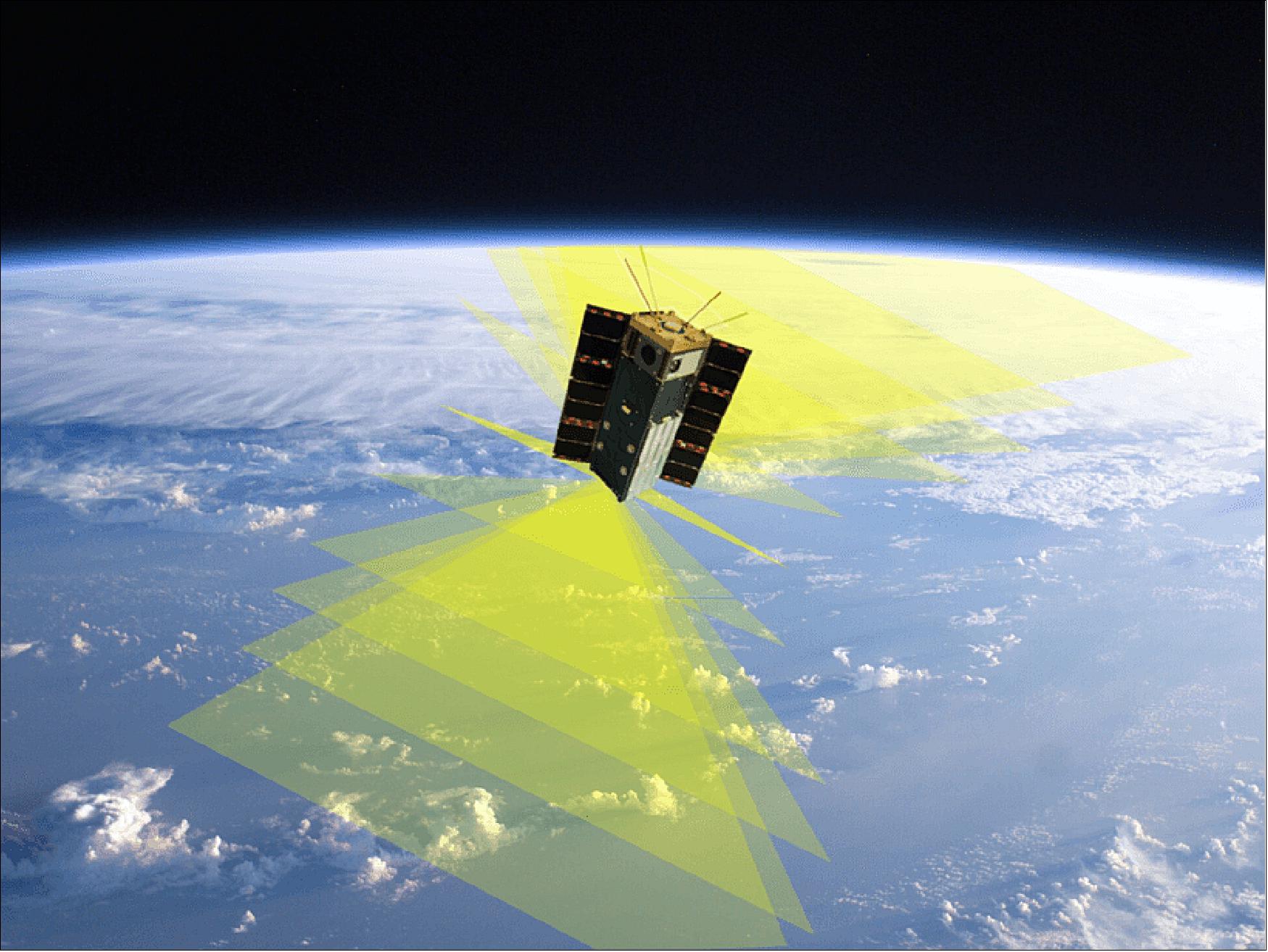
The 3U CubeSat is 3-axis stabilized designed to keep the imager pointing nadir during the data acquisition period. The hyper-angular capability is achieved by acquiring overlapping images at very fast speeds.
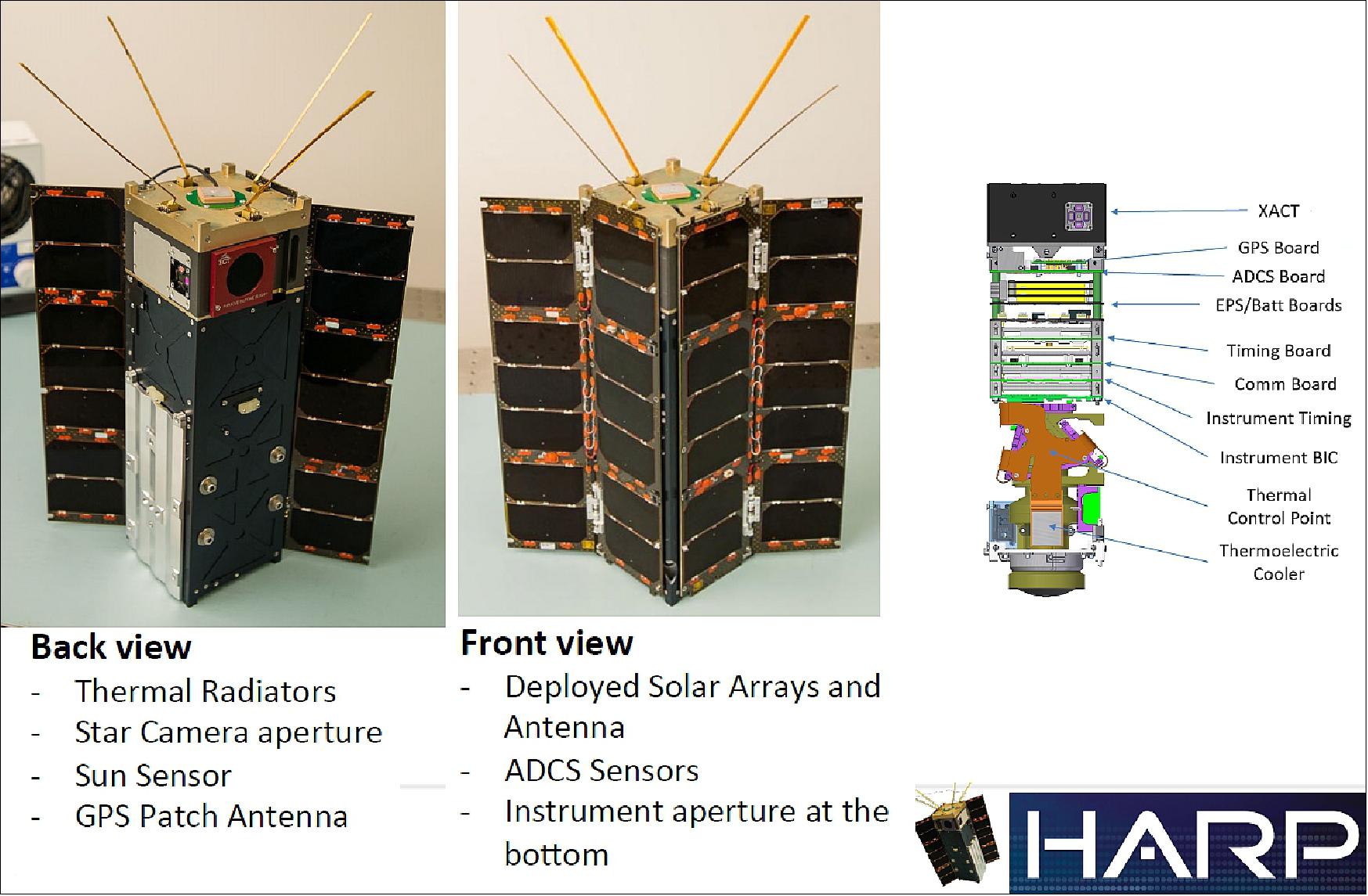
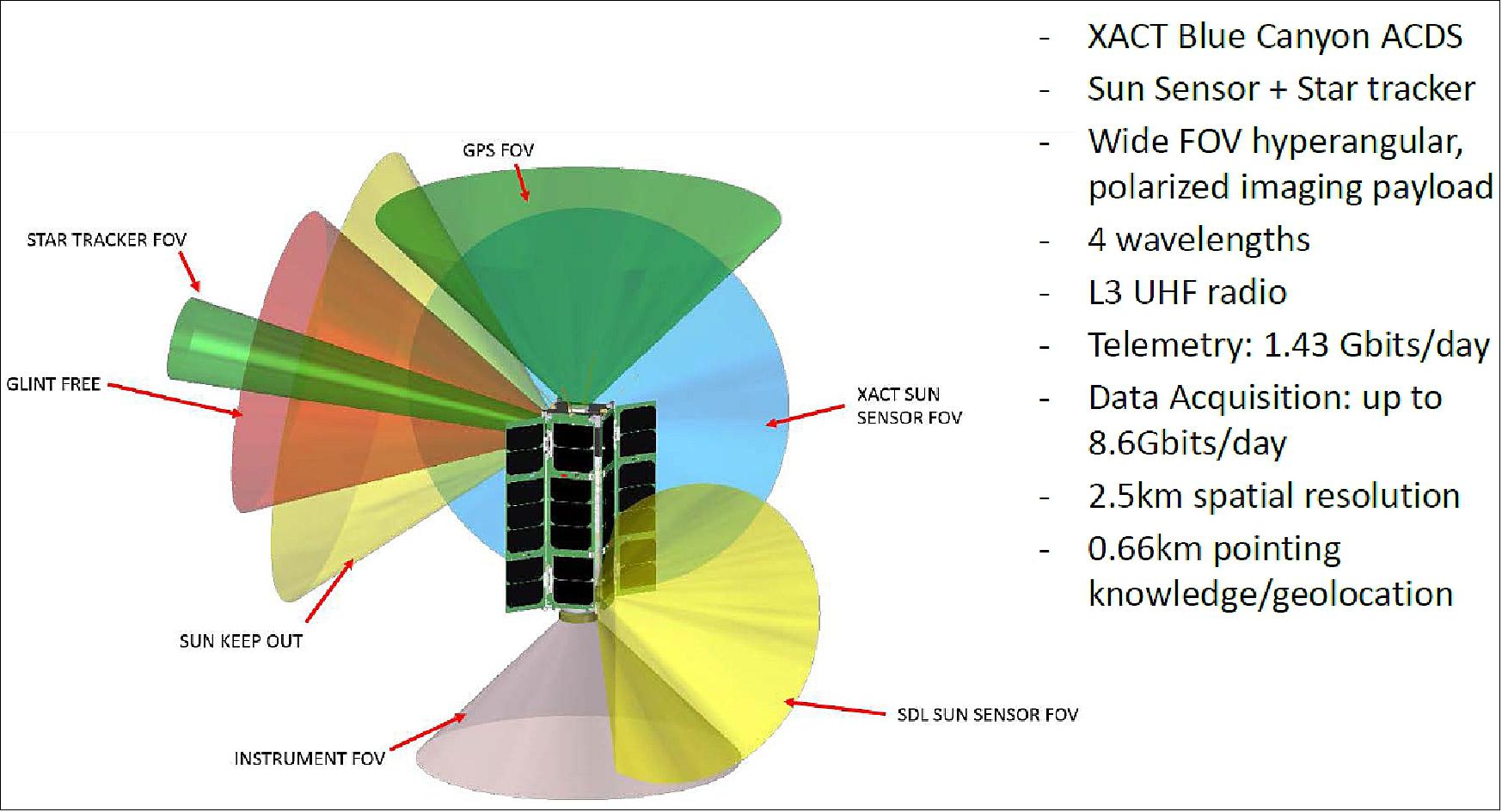
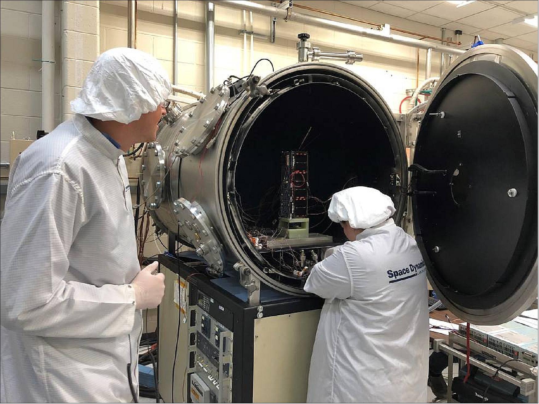
Figure 3: HARP Systems Engineer Ryan Martineau (left) and Thermal Vacuum Specialist Brittany Woytko configure HARP’s spacecraft in a thermal vacuum chamber at the Space Dynamics Laboratory in Logan, Utah. Woytko is connecting several temperature sensors to the spacecraft to monitor the instrument during testing. Once the door is shut on the chamber, it loses its air and simulates the vacuum of space. The chamber also heats and cools the spacecraft through several cycles to simulate the extreme hot and cold temperatures the spacecraft will pass through on orbit (image credit: USU/SDL) 5)
Launch
The HARP nanosatellite was launched as part of the ELaNa-25 mission on the ISS resupply mission of Northrop Grumman (Cygnus NG-12) on 2 November 2019 (13:59.47 UTC). The launch vehicle was the Antares 230 configuration and the launch site was MARS (Mid-Atlantic Regional Spaceport) on Wallops Island, VA. USA. 6)
Orbit: Near-circular orbit, altitude of ~ 400 km, inclination of 51.6º, period of ~92 minutes.
The ISS orbit has the advantage of allowing HARP to cross many other Earth Science Satellites (including Terra, Aqua, Aura, VIIRS on Suomi NPP, CALIPSO, etc.) and produce intercomparisons and a synergistic use of the HARP data together with data from these other platforms.
Secondary CubeSat Payloads of the Northrop Grumman-12 Cygnus Flight
• Argus-02, a 2U CubeSat (2.5 kg) of St. Louis University, Missouri. Argus’ mission is to improve the ability to model the effects of space radiation on modern electronics.
• HARP (Hyper Angular Rainbow Polarimeter), a 3U CubeSat of the University of Maryland, Baltimore County, Maryland and USU (Utah State University) - to measure the microphysical properties of cloud water and ice particles.
• Phoenix, a 3U CubeSat of ASU (Arizona State University), Tempe, AZ.
• RadSat-U (Radiation Satellite), a 3U CubeSat demonstration mission of Montana State University, Bozeman, MT.
• SOCRATES (Signal of Opportunity Cubesat Ranging and Timing Experiments), a 3U CubeSat of the University of Minnesota, Minneapolis.
External Cygnus Deployments:
• HuskySat, a 3U CubeSat technology demonstration mission (plasma propulsion) of the University of Washington, Seattle, WA.
• SwampSat II, a 3U CubeSat technology demonstration mission of the University of Florida, Gainesville, FL.
Mission status
• August 07, 2020: UMBC's (University of Maryland Baltimore County) Hyper-Angular Rainbow Polarimeter (HARP) Satellite, which began in Vanderlei Martins's imagination more than a decade ago, has been flying in low-Earth orbit since February 19. It contains new technology that can collect detailed information about tiny particles in the atmosphere - previously unmeasurable data that will inform climate studies for years to come. The HARP team, including a large number of students, overcame obstacles at every step of the satellite's journey to space, and its success is already being recognized. 7)
- On August 6, the American Institute of Aeronautics and Astronautics (AIAA) named HARP the Small Satellite Mission of the Year. To qualify as a “smallsat,” satellites must weigh less than 150 kg. To win, a smallsat must demonstrate significant improvement in the capability of small satellites. That could mean advances in their structural design, scientific instrumentation, communications ability, or other factors.
- A popular vote informed the AIAA SmallSat Technical Committee’s final decision. After voters selected HARP as a finalist, the smallsat went up against nine other finalists, including teams from the U.S., Guatemala, Singapore, and France. Votes for HARP poured in from all over the world, including ballots from 40 states and countries on six continents. In the end, HARP emerged as the winner.
A Moment of Joy
- “I would like to thank the HARP team as a whole, because HARP is really the result of the perseverance of the team over many years,” said Martins, director of UMBC’s Earth and Space Institute, as he accepted the award. “There has been no shortage of problems, but we have always worked together to overcome them.”
- HARP’s innovative design and ability to collect new kinds of data that will be crucial for future research sealed the win. The HARP instrument, designed and built by a UMBC team and funded by the NASA Earth Science Technology Office, is smaller than a loaf of bread. Yet, its pioneering polarimeter (the first ever in orbit) can measure certain properties of particles in the atmosphere for the first time, offering a new look at the properties of clouds and tiny particles in the atmosphere called aerosols. The first observation from HARP arrived back on Earth on April 16, and it’s been collecting data continuously since.
- The small spacecraft developed by UMBC’s partners at Space Dynamics Lab (SDL) carried HARP to space, and the SDL team manages the satellite while it is in orbit. The whole satellite (instrument plus spacecraft) is the size of a large loaf of bread and only weighs about 6 kg (13 lbs.). UMBC shares the award with Space Dynamics Lab, which is affiliated with Utah State University.
- “All of us at UMBC are so very proud of the efforts and the impact of Vanderlei Martins and the Earth & Space Institute,” says Karl Steiner, UMBC’s vice president for research. “Looking back at the launch of the HARP satellite at Wallops Island this past November, I know that today’s recognition as SmallSat Mission of the Year brings a much-needed moment of joy and encouragement to our campus community during a very different time.”

Student-Driven Success
- The AIAA also gave out a People’s Choice Award (PCA) at the ceremony. The awards committee selects a PCA when a project has made substantial, unique contributions, but doesn’t necessarily meet the requirements for Mission of the Year. This year, Quetzal 1, Guatemala’s first-ever satellite, received the People’s Choice Award. Quetzal 1 has “opened the whole field of space science and technology in Guatemala,” shared Emily Clemens, awards committee chair.
- Guatemala currently has no engineering graduate school programs and no space agency, noted Luis Zea, one of Quetzal 1’s co-directors, “but the students here accomplished something that I think is a good example of what young people can do when they set their minds to solving problems.”
- Students are at the root of HARP, as well. The team has included scientists and engineers at every level. High school students, undergraduates, and graduate students all made important contributions in collaboration with faculty researchers.
- “HARP is a small satellite, but we always had very big ambitions,” Martins says. At long last, those ambitions are bearing fruit. Some of the students who worked on HARP, and some new ones, are now at work on HARP2, which will build on technology developed for HARP. HARP2 will travel on the major NASA PACE mission, scheduled to launch in 2023. HARP2 will collect data that will inform studies of air quality, clouds, precipitation, and climate.
- With only a tinge of disbelief, and a big smile, Martins says, “And that’s all due to this small satellite.”
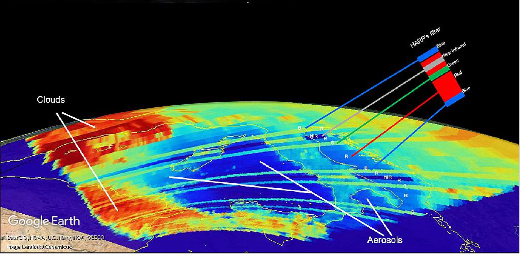
• May 14, 2020: The Hyper-Angular Rainbow Polarimeter (HARP) CubeSat achieved “first light” on April 16. The tiny satellite sent back its very first image over Europe with bright splashes of colors defining clouds and aerosols, which are tiny particles in the atmosphere. HARP’s measurements help us better understand how clouds and aerosols impact weather, climate and air quality. 8)
- HARP filters light into four wavelengths and uses a prism to rotate that light to three polarization angles. Just as polarized sunglasses help block bright light of a specific polarization to help you see past the sun's glare, HARP can block certain wavelengths and make observations from many angles. The CubeSat reveals what is hidden to the naked eye: amounts and types of aerosols as well as the size of water droplets or ice particles inside clouds.
- “Every time HARP flies over a region, we see that region from multiple perspectives,” Vanderlei Martins, HARP principal investigator and a professor at the University of Maryland, Baltimore County, said. HARP launched to the International Space Station from NASA’s Wallops Flight Facility, Virginia, on Nov. 2, 2019. In February 2020, the CubeSat floated away from the space station and began its orbit around Earth.
- HARP marks NASA’s first attempt to put a polarimeter, which measures the polarization of light, aboard a CubeSat. HARP could pave the way for future NASA missions involving a constellation of little satellites peering down at clouds and aerosols, Martins said.
- HARP also inspired a successor called HARP2, which is an instrument that will fly on NASA’s Plankton, Aerosol, Cloud, ocean Ecosystem (PACE) mission. HARP2 is a copy of the HARP CubeSat polarimeter payload adapted for flying and collecting data from a large spacecraft platform like PACE.
- Currently under development, PACE will extend and improve NASA’s 20-plus-year record of satellite observations of global ocean biology, chemistry, aerosols and clouds. HARP2 will be able to operate all the time and collect significantly more science data than the HARP CubeSat.
• February 19, 2020: Today the HARP CubeSat made history by becoming the 100th CubeSat Launch Initiative (CSLI) selected mission deployed into space. This mission marks nearly 12 years of the CSLI providing CubeSat developers rideshare opportunities to space via Educational Launch of Nanosatellites (ELaNa) missions. 9)
- “This 100th mission is extremely noteworthy because it highlights just how special and valuable CSLI is. Not only does the initiative provide real-life, hands-on experience to the next generation of space exploration professionals, it also adds tremendous value and moves NASA’s mission forward in meaningful ways,” said Jim Norman, director, Launch Services at NASA Headquarters in Washington. "I want to thank all the university students, faculty and staff, industry partners and NASA centers who have participated in this program for their contributions.”
- HARP is a 3U CubeSat designed to measure the microphysical properties of atmospheric aerosols, cloud water and ice particles. It is a precursor for a new generation of imaging polarimeters to be used for the detailed measurements of aerosol and cloud properties in larger missions. The wide field-of-view imager splits three spatially identical images into three independent polarizer and detector arrays. This technique achieves simultaneous imagery of the three polarization states and is the key innovation to achieve a high polarimetric accuracy with no moving parts. The mission is expected to spend nearly a year in orbit with three months dedicated to technology demonstrations and an extended science data period of an additional seven months.
• February 19, 2020: NanoRacks has completed the Company’s 17th CubeSat deployment mission from the International Space Station using commercially developed and operated hardware. 10)
- NanoRacks’ 17th CubeSat deployment mission included satellites launched to the International Space Station on both Northrop Grumman’s NG-12 flight (launch on 2 November 2019) and the SpaceX CRS-19 (launch 5 December 2019) mission. The deployer packs were then assembled together on orbit by the astronaut crew.
- “The diversity of users on each CubeSat mission is growing with every flight,” says NanoRacks Senior External Payloads Mission Manager, Tristan Prejean. “Our 17th CubeSat mission has satellites built by university students, international space agencies and research institutes, commercial companies reaching the ISS for the first time, and by our friends at NASA. Commercial access to low-Earth orbit is enabling an unprecedented cohort of users from around the world to make discoveries in space – and we are watching this grow year by year.”
- The satellites released on February 19, 2020 and their deployment times were:
a) RadSat-U (Montana State University) – 07:10:01 GMT
b) Phoenix (Arizona State University) – 09:35:00 GMT
c) QARMAN (von Karman Institute) – 11:20:00 GMT
e) CryoCube (Sierra Lobo Incorporated/NASA Kennedy) and AzTechSat-1 (Collaborative program between NASA Ames and Universidad Popular Autónoma del Estado de Puebla [UPAEP] in Mexico) – 12:55:01 GMT
f) SOCRATES (University of Minnesota) – 14:30:00 GMT
g) HARP (University of Maryland, Baltimore County) and ARGUS-02 (Saint Louis University) – 16:00:00 GMT
h) SORTIE (Astra LLC)- 17:40:00 GMT
Sensor Complement
Imaging Polarimeter
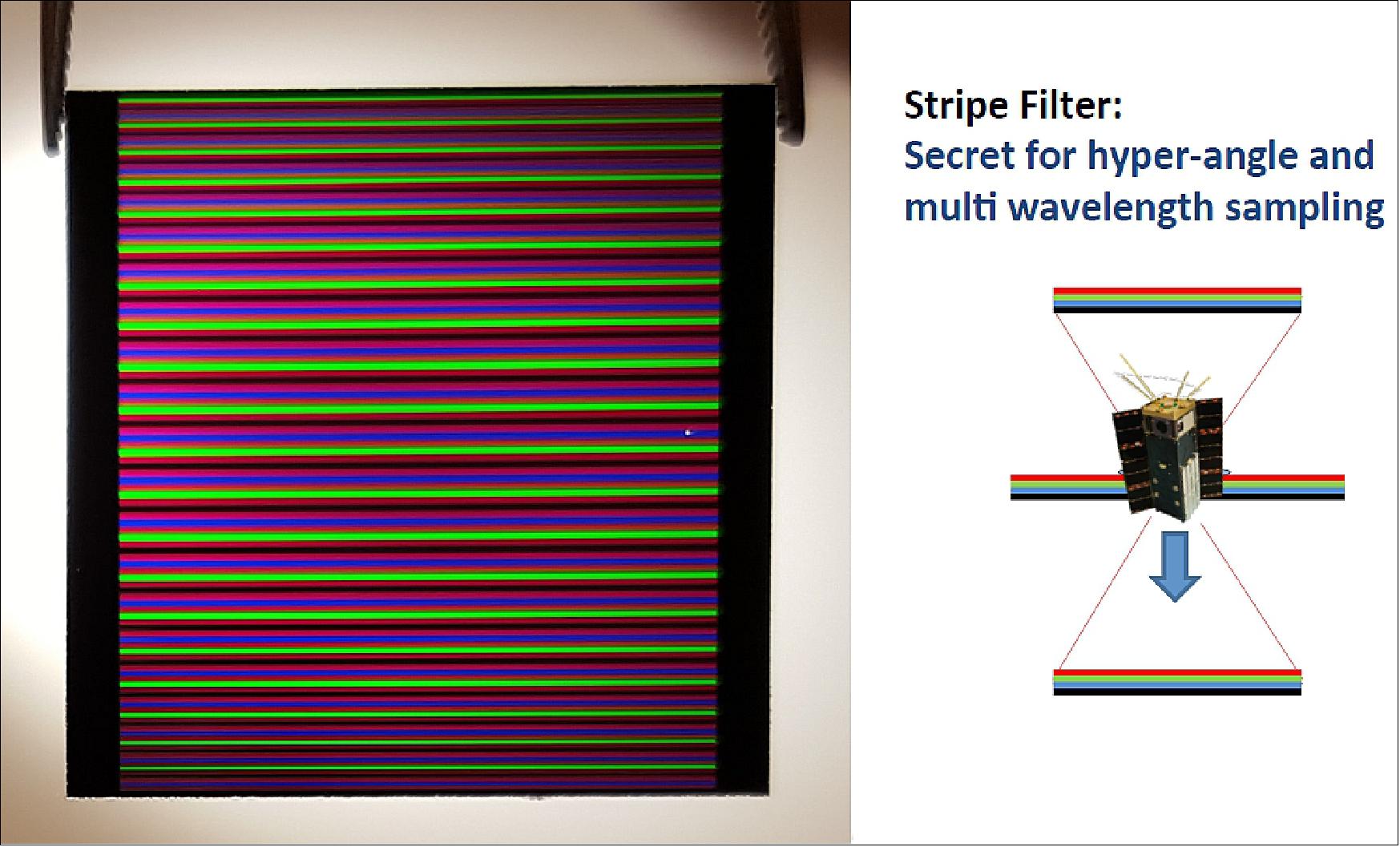
HARP will be the first US imaging polarimeter in Space. Polarization measurements are used because the technique provides new information on aerosol and cloud properties and their interaction. HARP design is an advance over POLDER’s (POLarization and Directionality of the Earth's Reflectances) filter wheel system. The HARP polarimeter will provide full cloudbow retrievals from a small area (< 4 km x 4 km from space).
Cloud and aerosol processes influence climate change, which affect our oceans, weather, ecosystems, and society. The largest impediments to estimating climate change revolve around a lack of quantitative information about aerosol forcing, insufficient understanding of aerosol-cloud processes, and cloud feedbacks in the climate system. The climate community requires new observations and a better understanding of aerosol and cloud processes to narrow climate change estimate uncertainties. The aerosol community requires a multi-wavelength, multi-angle imaging polarimeter with the wide FOV imaging heritage of the POLDER mission and the high accuracy promised by the APS (Aerosol Polarimetry Sensor). Unfortunately, APS was lost when the Glory mission failed to reach orbit.
An imaging polarimeter with hyperangular capability can make a strong contribution to characterizing cloud properties, especially ice clouds. Because of their sensitivity to thin cirrus clouds, non-polarized multi-angle measurements can be used to provide climatology. Adding polarization and increasing the number of observation angles provides a much clearer picture of cloud droplet distribution, adding size and width measurements to the currently measured effective radius. The combination of hyperangular polarized measurements and short-wave infrared channels (2.1 µm) should also provide enough constraints to determine important characteristics of cloud ice crystals. In the coming decades, it will be important to have an imaging polarimeter with the capability to characterize both aerosols and clouds. Highly-capable, small, and versatile, HARP is designed to meet the needs of both the aerosol and cloud communities.
The HARP payload, a hyperangular imaging polarimeter that can see Earth from multiple viewing angles, 4 wavelengths, and three polarization angles was developed and is being built at LACO (Laboratory for Aerosol, Clouds and Optics) in the Physics Department at UMBC with support from JCET (Joint Center of Earth Systems and Technology) and NASA/GSFC (Goddard Space Flight Center). The HARP science algorithms will be developed in collaboration between UMBC and STC (Science and Technology Corporation). The main characteristics of the HARP payload are described in Table 1. 11) 12)
Polarimeter Specifications
• One hyper-angular channel with up to 60 viewing angles per pixel at 670 nm (for cloudbow measurements)
• Three channels with up to 20 viewing angles per pixel at 440, 550, 670 nm
• Goal of one additional channel with up to 20 viewing angles at 870 nm
• 2.5 km nadir resolution (from 650 km orbit)
• 94 degree FOV in cross-track
• 110 degree FOV in along track
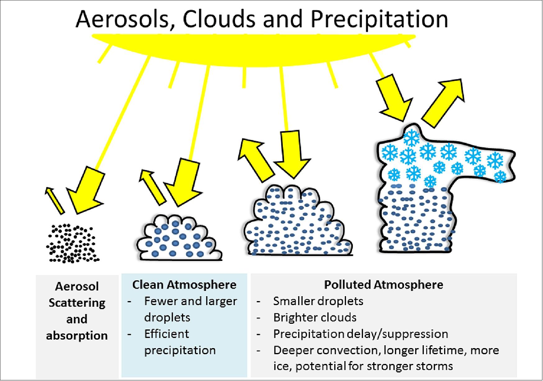
HARP is designed to see how aerosols interact with the water droplets and ice particles that make up clouds. Aerosols and clouds are deeply connected in Earth's atmosphere – it's aerosol particles that seed cloud droplets and allow them to grow into clouds that eventually drop their precipitation (Figure 7). 13)
This interdependence implies that modifying the amount and type of particles in the atmosphere, via air pollution, will affect the type, size and lifetime of clouds, as well as when precipitation begins. These processes will affect Earth's global water cycle, energy balance and climate.
When sunlight interacts with aerosol particles or cloud droplets in the atmosphere, it scatters in different directions depending on the size, shape and composition of what it encountered. HARP will measure the scattered light that can be seen from space. We'll be able to make inferences about amounts of aerosols and sizes of droplets in the atmosphere, and compare clean clouds to polluted clouds.
In principle, the HARP instrument would have the ability to collect data daily, covering the whole globe; despite its mini size it would be gathering huge amounts of data for Earth observation. This type of capability is unprecedented in a tiny satellite and points to the future of cheaper, faster-to-deploy pathfinder precursors to bigger and more complex missions.
HARP is one of several programs currently underway that harness the advantages of CubeSats for science data collection. NASA, universities and other institutions are exploring new earth sciences technology, Earth's radiative cycle, Earth's microwave emission, ice clouds and many other science and engineering challenges.
The HARP polarimeter is fully programmable and will allow for the selection of different spatial resolutions and combinations of wavelengths and viewing angles depending on the science interest and total amount of data to downlink. The different along track viewing angles from HARP will allows the observations of targets on the ground from different viewing perspectives. These different viewing observations of the same target allow for additional information from the target facilitating the quantitative retrieval of information from the atmosphere and surface properties such as the aerosol particle amount, the cloud droplet sizes, and specific characteristics of Earth’s surface.
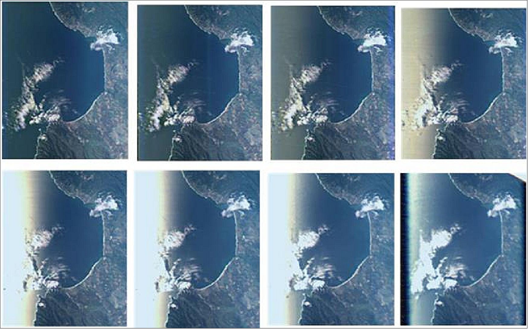
Legend to Figure 12: The PACS (Passive Aerosol & Clouds Suite) polarimeter serves as an airborne simulator for the HARP imaging polarimeter. The different perspectives in the images emphasize the variation of the reflection of the sun on the ocean surface as a function of the viewing angle. In some along track viewing angles this reflection disappears while in other angles this reflections appear very intensively.
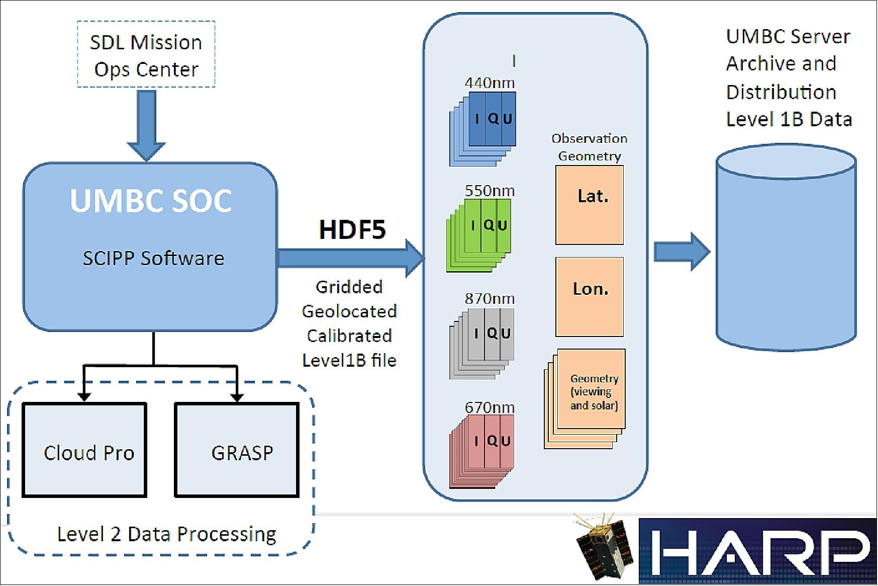
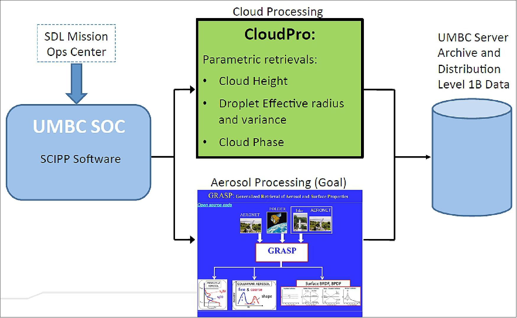
UMBC SOC (University of Maryland Baltimore County - Science Operations Center)
References
1) J. Vanderlei Martins, ”HARP: Hyper-Angular Rainbow Polarimeter CubeSat,” ESTO Science and Technology Forum, June 14, 2016, URL: https://esto.nasa.gov/forums/estf2016/PRESENTATIONS/Martins_A1P2_ESTF2016.pdf
2) ”HARP Hyper-Angular Rainbow Polarimeter,” USU/SDL, URL: https://www.sdl.usu.edu/media-events/media-library/pdf/harp/
3) ”Hyper-Angular Rainbow Polarimeter (HARP) CubeSat,” Feb. 2015, URL: http://userpages.umbc.edu/~martins/laco/HARP%20QuadChart%20Feb%202015.pdf
4) J. Vanderlei Martins, Tim Nielsen, Chad Fish, Leroy Sparr, Roberto Fernandez-Borda, Mark Schoeberl, Lorraine Remer, ”HARP CubeSat–An innovative Hyperangular Imaging Polarimeter for Earth Science Applications,” Small Sat Pre-Conference Workshop, Logan Utah, 3 Aug 2014, URL: http://digitalcommons.usu.edu/cgi/viewcontent.cgi?
filename=0&article=3154&context=smallsat&type=additional
5) ”Tiny NASA Satellite Will Soon See ‘Rainbows’ In Clouds,” NASA Feature, 28 October 2019, URL: https://www.nasa.gov/feature/goddard/2019/tiny-nasa-satellite-will-soon-see-rainbows-in-clouds
6) ”NASA Science, Cargo Heads to Space Station on Northrop Grumman Mission,” NASA Press Release 19-087, 2 November 2019, URL: https://www.nasa.gov/press-release/
nasa-science-cargo-heads-to-space-station-on-northrop-grumman-mission
7) ”Small satellite, big ambitions: UMBC's HARP named SmallSat Mission of the Year,” UMBC, 7 August 2020, URL: https://news.umbc.edu/small-satellite-big-ambitions-umbcs-harp-named-smallsat-mission-of-the-year/
8) Elizabeth Goldbaum, ”Tiny NASA Satellite Captures First Image of Clouds and Aerosols,” NASA, 14 May 2020, URL: https://www.nasa.gov/image-feature/goddard/2020
/tiny-nasa-satellite-captures-first-image-of-clouds-and-aerosols
9) Denise Hill, ”The CubeSat Launch Initiative Celebrates its 100th CubeSat Mission Deployment,” NASA Feature, 19 February 2020, URL: https://web.archive.org/web/20230310083325/https://www.nasa.gov/feature/the-cubesat-launch-initiative-celebrates-its-100th-cubesat-mission-deployment
10) ”NanoRacks Completes 17th Commercial Space Station CubeSat Deployment Mission,” NanoRacks, 19 February 2020: https://nanoracks.com/
nanoracks-completes-17th-commercial-space-station-cubesat-deployment-mission/
11) ”HARP Overview,” UMBC/LACO, URL: http://userpages.umbc.edu/~martins/laco/harp.htm
12) Brent McBride, ”Polarimetric remote sensing with the Hyper-Angular Rainbow Polarimeter, 3U CubeSat,” Sept. 17, 2015, URL: http://cicsmd.umd.edu/assets/1/7/30_Brent_McBride.pdf
13) Vanderlei Martins, ”Tiny satellites poised to make big contributions to essential science,” UMBC, January 27, 2017, URL: https://phys.org/news/2017-01-tiny-satellites-poised-big-contributions.html
The information compiled and edited in this article was provided by Herbert J. Kramer from his documentation of: ”Observation of the Earth and Its Environment: Survey of Missions and Sensors” (Springer Verlag) as well as many other sources after the publication of the 4th edition in 2002. - Comments and corrections to this article are always welcome for further updates (eoportal@symbios.space).
Spacecraft Launch Mission Status Sensor Complement References Back to top