Helios-2 A/B
EO
High resolution optical imagers
Multi-purpose imagery (land)
Land surface imagery
Launched in December 2004 and 2009 respectively, Helios-2A and -2B are identical military reconnaissance satellites, owned and operated by the French Space Agency (CNES) and Directorate General of Armaments (DGA), the defence procurement agency. Helios-2A and -2B aim to provide high resolution for a range of missions, including enforcing disarmament treaties, planning and executing military operations and evacuating nationals.
Quick facts
Overview
| Mission type | EO |
| Agency | CNES |
| Mission status | Operational (extended) |
| Launch date | 18 Dec 2004 |
| Measurement category | Multi-purpose imagery (land) |
| Measurement detailed | Land surface imagery |
| Instrument type | High resolution optical imagers |

Summary
Mission Capabilities
Both Helios-2A and -2B carry identical sensor complements, consisting of a high-resolution visible (VIS) and infrared (IR) imaging instrument, and a wide-field visible imager.
Performance Specifications
Due to the classified nature of the mission, the instrument specifications are unclear. However, the high-resolution VIS/IR imager is reported to have a spatial resolution of approximately 0.35 m, according to officials knowledgeable about the program.
Helios-2A and -2B operate in near identical quasi-polar, sun-synchronous, Low Earth Orbits (LEO). 2A has an apogee of 690 km and a perigee of 688 km, with an orbital inclination of 98.08°, while 2B has an apogee of 685 km and a perigee of 670 km, with an orbital inclination of 98.10°. Helios-2B orbits 180° out of phase with 2A, allowing for daily global coverage.
Space and Hardware Components
The Helios-2 satellites both use the SPOT-5 bus with dimensions of 3.4 m x 3.1 m x 6 m excluding the solar array, and a launch mass of approximately 4200 kg. The Attitude Control Subsystem (ACS) provides a pointing accuracy of 0.05°, and the bus carries an autonomous star tracker, capable of providing location accuracy of less than 50 m, without ground control points. Data downlink is in X-band, with a maximum data rate of 100 Mbit/s.
Overview
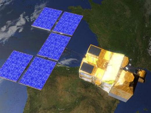
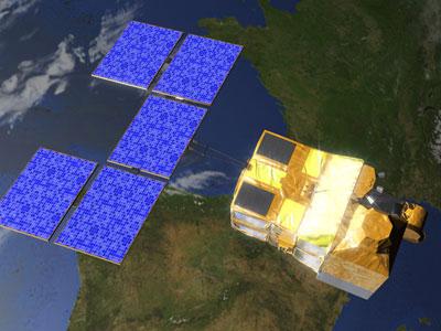
The Helios constellation is a series of largely French-developed military reconnaissance satellites. The current Helios-2 program, successor to the original Helios missions, consists of two identical satellites, Helios-2A and Helios-2B, shown in Figure 1. The program was 90% funded by France, with contributions from Belgium, Spain, Italy and Greece, who each own a 2.5% share, and facilitated by the French defence procurement agency, the Directorate General of Armaments (DGA). Helios also features a ground segment, designed by Airbus, a primary contractor, and a control centre operated by the French National Centre for Space Studies (CNES). Helios imagery is used by European stakeholder governments and militaries for a range of missions, including enforcing disarmament treaties, planning and executing military operations and evacuating nationals. 3) 4) 5) 10)

Spacecraft
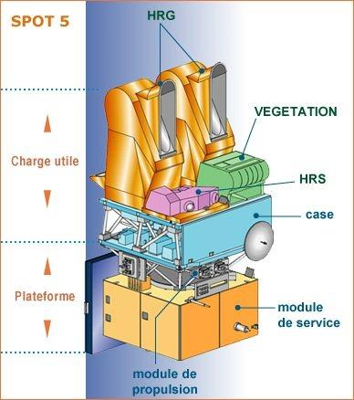
The Helios-2 satellites both use the SPOT-5 bus, shown in Figure 2, with dimensions of 3.4 m x 3.1 m x 6 m, excluding the solar array, and a launch mass of approximately 4200 kg. The Attitude Control Subsystem (ACS) provides a pointing accuracy of 0.05°, with attitude restitution of 6 x 10⁻⁵ radians. The bus carries an autonomous star tracker, capable of providing location accuracy of less than 50 m, without ground control points. The Onboard Data Handling Subsystem (OBDH) consists of an Onboard Processor (OBC), the Marconi MDC 31750 processor unit, as well as a decoding and reconfiguration unit, which decodes uplinked telecommands and monitors and reconfigures critical systems such as the OBC itself. The bus also features onboard solid-state recording capacity of 90 Gbit, with onboard data compression of source data provided by DCT (Direct Cosine Transform), achieving compression ratios of 2.28 - 2.8. Data downlink is in X-band, with a data rate of 2 x 50 Mbit/s, enabled by an image transmission assembly consisting of two Quadrature Phase Shift Keying (QPSK) modulators, two X-band solid-state power amplifiers (SSPA) and an output multiplexer (OMUX) filter that filters and combines signals. Both Helios-2A and -2B carry a solar array consisting of two Gallium Arsenide panels and three silicon panels, with four 40 Ah batteries for onboard power storage. 9)

Launch
Helios-2A was launched on December 18, 2004, aboard an Ariane-5G+ launch vehicle, into a quasi-polar, sun-synchronous, Low Earth Orbit (LEO), with an apogee of 690 km and a perigee of 688 km, and an orbital inclination of 98.08°. Helios-2B was launched on December 18, 2009, aboard an Ariane-5GS launch vehicle, and was placed into a near identical LEO, with an apogee of 685 km and a perigee of 670 km, with an orbital inclination of 98.10°. Helios-2B is 180° out of phase with Helios-2A, allowing full global coverage in 24 hours. 7)
Mission Status
- December 18, 2004: Helios-2A is successfully launched and inserted into orbit aboard an Ariane-5G+ launch vehicle
- January 1, 2005: Helios-2A produces and transmits its first images, confirming the health and functionality of onboard systems 2)
- December 18, 2009: Helios-2B is successfully launched and inserted into a near identical orbit aboard an Ariane-5GS launch vehicle
- January 4, 2010: Helios-2B delivers its first test images, confirming its onboard systems are operational 1)
- July 13, 2012: CNES renews their contract with SPACEBEL, a Belgian space systems and software engineering company working on Helios-2 data processing, for an additional six years, until 2018 8)
Sensor Complement
Both Helios-2A and -2B carry identical sensor complements, consisting of a high-resolution visible (VIS) and infrared (IR) imaging instrument, and a wide-field visible imager. Instrument specifications have not been provided by either CNES or DGA, but the high-resolution VIS/IR imager is reported to have a spatial resolution of approximately 0.35 m, according to officials knowledgeable about the program. The VIS/IR instruments were manufactured by Thales Alenia Space, a Franco-Italian aerospace company, while the wide-view VIS imager was provided by Airbus Defence and Space. 5)
Ground Segment
The Helios-2 ground segment consists of two sections, the user ground segment, for the reception and processing of Helios-2 data, and the programming loop, for determining imaging priorities. The user ground segment consists of main Helios centres in each of the participating nations, with Belgium, Spain, Italy, Greece owning a 2.5% share in the program, and Germany gaining access through a bilateral information exchange agreement, wherein France receives access to German SAR-Lupe satellite imagery. These Helios centres receive encoded imagery on each satellite pass, and decode and process data onsite. The Helios-2 programming loop is a daily operation that follows a precise timetable: 6)
- Each country forms a list of images to be acquired
- Partners discuss which requests should be given priority
- Plans are transmitted to the satellite positioning and operations control centre (CMP), which forms executable telecommands and transmits them to the satellites
- Imagery is collected by the Helios satellites
- Encoded images are downlinked to Helios centres when the satellites pass over
- Obtained images are decoded, processed and distributed to users.
References
1) de Selding, Peter B. “French Helios 2B Spy Sat Sends Back First Test Images.” SpaceNews, 4 January 2010. URL: https://spacenews.com/32557french-helios-2b-spy-sat-sends-back-first-test-images/
2) SpaceNews, “France's Helios 2A Recon Satellite Produces First Images”, 31 January 2005, URL: https://spacenews.com/frances-helios-2a-recon-satellite-produces-first-images/
3) Astronautix, “Helios 2.” URL: http://www.astronautix.com/h/helios2.html
4) Gunter's Space Page, “Helios 2A, 2B - Gunter's Space Page.” URL: https://space.skyrocket.de/doc_sdat/helios-2a.htm
5) CNES, “Hélios | Helios.” 5 March 2019. URL: https://helios.cnes.fr/en/helios-0
6) CNES "HELIOS II, a new generation of military satellites.” URL: https://cnes.fr/en/web/CNES-en/2743-helios-ii-a-new-generation-of-military-satellites.php
7) SatelliteObservation.net, “Orbital Characteristics of the Helios system.” URL: https://satelliteobservation.files.wordpress.com/2016/11/helios_final_gb.pdf
8) Spacebel, “Renewal of HELIOS-2 Contract for SPACEBEL.” https://www.spacebel.com/news/renewal_of_helios-2_contract_for_spacebel/14
9) CNES, “SPOT-5.” URL: http://spot5.cnes.fr/gb/satellite/484.htm
10) Spacebel, “Who we are.” URL: https://www.spacebel.com/en/about-us/who-we-are