HySIS (HyperSpectral Imaging Satellite)
EO
Ocean
Multi-purpose imagery (ocean)
Imaging multi-spectral radiometers (vis/IR)
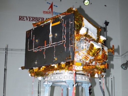
The Hyperspectral Imaging Satellite (HysIS) is an Indian Space Research Organization (ISRO) developed hyperspectral Earth observation minisatellite designed to provide imaging services and insights into Indian agriculture, forestry, coastal zone assessments and other geological environments. Launched in November 2018, HySIS imaged through visible (VIS), near infrared (NIR) and shortwave infrared (SWIR) surface imaging to achieve its goals.
Quick facts
Overview
| Mission type | EO |
| Agency | ISRO |
| Mission status | Operational (nominal) |
| Launch date | 29 Nov 2018 |
| Measurement domain | Ocean, Land |
| Measurement category | Multi-purpose imagery (ocean), Multi-purpose imagery (land) |
| Measurement detailed | Land surface imagery, Vegetation Cover, Land cover, Land surface topography, Visibility |
| Instruments | SWIR, VNIR Hyperspectral Solar Disk Imager (ESP-MACCS) |
| Instrument type | Imaging multi-spectral radiometers (vis/IR), Data collection, Hyperspectral imagers |
Summary
Mission Capabilities
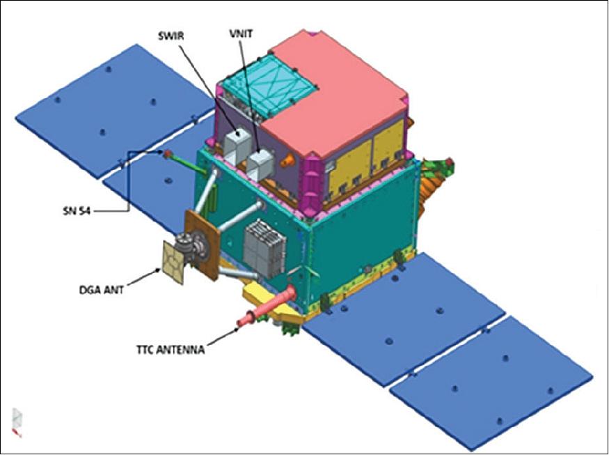
HySIS carries two pushbroom imagers where one captures images in the Visible Near Infrared (VNIR) range and the other in the Shortwave Infared (SWIR) range. They are utilised for Earth observation imagery and contain an optical imaging detector array chip designed by ISRO’s Space Application Centre (SAC).
Perfomance Specifications
The VNIR sensor images over 55 spectral bands, with a bandwidth of 10 nm, spatial resolution of 30 m and a swath width of 30 km. The VNIR spectral range is between 0.4-0.95 µm, and the SWIR spectral range is from 0.85-2.4 µm.
HysIS orbits in a sun-synchronous orbit at an altitude of 636.6 km and an orbital inclination of 97.96°.
Space and Hardware Components
HysIS utilises the ISRO Mini Satellite-2 bus (IMS-2) to house communications and imaging payloads. Launched in 2018, the mission was designed with a five year lifetime, with an expected end of life in 2023.
HySIS (HyperSpectral Imaging Satellite)
Overview Spacecraft Launch Mission Status Sensor Complement References
Overview
ISRO (Indian Space Research Organization) developed HySIS, a full-fledged hyperspectral EO (Earth Observation) satellite for launch in 2018. The HySIS is meant to provide hyperspectral imaging services to the country for a range of applications in agriculture, forestry and assessment of coastal zones, inland waters, soil and other geological environments, etc.
HySIS, the primary satellite of PSLV-C43 mission, weighing about 380 kg, is an Earth observation satellite configured around ISRO's Mini Satellite-2 (IMS-2) bus. The primary goal of HysIS is to study the Earth's surface in the visible, near-infrared and shortwave infrared regions of the electromagnetic spectrum.
Spacecraft
HySIS is a Hyper Spectral Imaging Satellite for providing global coverage on a repetitive basis to users and supplementing the data from the existing multispectral sensors. A wide range of applications in agriculture, forestry, geological environments, coastal zones and inland waters, etc. are derived from the satellite data.
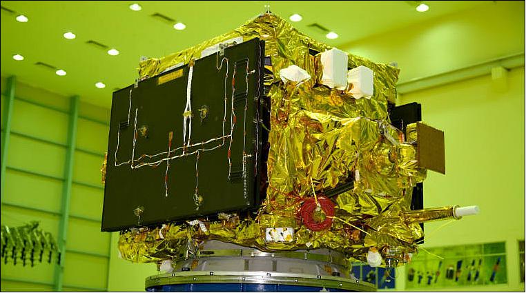
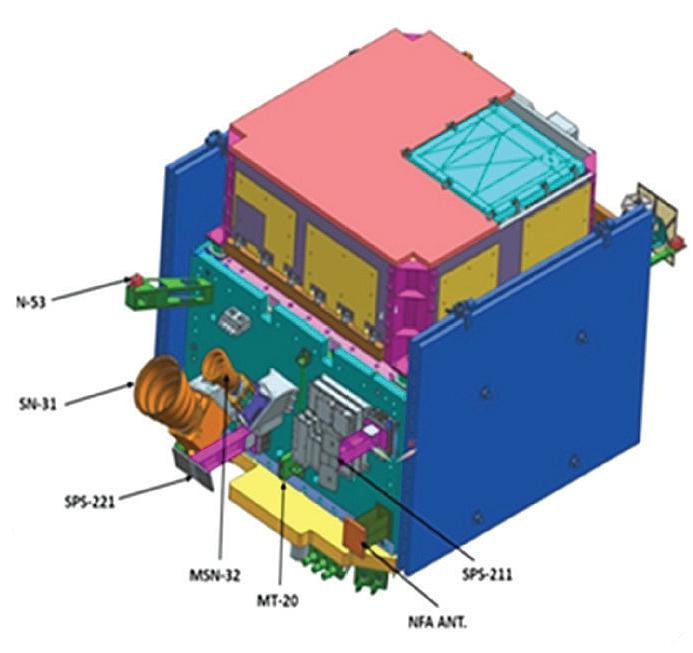
Built around the IMS-2 (ISRO Mini Satellite-2) bus, HySIS is 2.158 m x 1.386 m x 1.121 m with a mass of 380 kg. The satellite's payload also consists of a 730 W power backup, and a 64 Ah Li-ion battery. The mission design life of HySIS is 5 years.
Launch
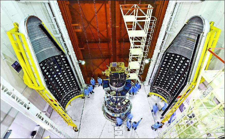
The HySIS minisatellite was launched on 29 November 2018 (04:28 UTC, 9:58 IST) on a PSLV-C43 vehicle from SDSC (Satish Dhawan Space Center) SHAR on the east coast of India. 1)
Orbit of HySIS: Sun-synchronous orbit, altitude of 636.6 km, inclination of 97.957º.
Orbit of passenger payloads: Sun-synchronous orbit, altitude of 504.5 km, inclination of 97.468º.

Secondary Payloads
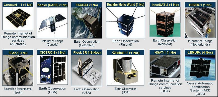
The co-passengers of HysIS include 1 microsatellite and 29 nanosatellites from eight different countries (23 are from the USA). All these satellites have been commercially contracted for launch through ISRO's commercial arm Antrix Corporation Limited. The total mass of the secondary payloads is 261.5 kg. 3)
• Two Lemur-2 nanosatellites (5 kg each) of Spire Global. Both satellites were developed under ESA's ARTES program to prove the value of nanosatellites in weather monitoring (spaceborne radio occultation). Experts can use these measurements to glean temperature, pressure and humidity information for weather forecasting and climate change monitoring. Named ‘Space as a Service', the Spire Pioneer mission intends to prove that nanosat GNSS-RO is a commercially-viable alternative to traditional methods. ESA's Pioneer initiative partners with companies like Spire to help them provide this kind of in-orbit demonstration and validation for third parties. 4) The two tiny satellites will collect and distribute GNSS-RO data during their commissioning phase, after which they will go into full commercial data production mode, gathering weather information for meteorological institutions, and maritime and aviation customers on demand.
• In addition two more Lemur-2 3U CubeSats of Spire Global with HQs in San Francisco were onboard.
• Centauri I nanosatellite of Fleet Space Technologies, Australia. Centauri I is a 3U nanosatellite, designed by Fleet Space Technologies and built by Pumpkin Space Systems.
• Flock-3r, a payload being carried for Planet Labs (San Francisco), consists of sixteen 3U CubeSats.
• CICERO-8 (Community Initiative for Cellular Earth Remove Observation-8) is a 6U CubeSat of GeoOptics Inc., Pasadena, CA. The nanosatellite carries a radio occultation payload that will use signals from both GPS and European Galileo satellites.
• HSAT-1 of Harris Corporation is another 6U, CubeSat. HSAT-1 will carry out a technology demonstration mission and carries Earth imaging and AIS receiver payloads. HSAT-1 will use Globalstar satellites for its primary method of communication with the ground, with an S-band radio carried as a backup. The satellite is expected to operate for two years.
• Hiber-1 is a 6U CubeSat of Hiber Global of the Netherlands. Hiber-1 is a demonstration mission for a future planned low Earth orbit communications network. Hiber plans to launch up to fifty satellites to provide worldwide connections for IoT (Internet of Things) devices.
• CASE – which is being carried for Canada's Kepler Communications – will serve as a pathfinder for a constellation of communications satellites to link IoT devices. Named after a robot in the film Interstellar, CASE follows on from the KIPP satellite that was deployed by a Chinese Chang Zheng 11 rocket in January. CASE is a 3U CubeSat that was built by Glasgow-based Clyde Space.
• FACSAT-1, the first 3U CubeSat to be operated by the Colombian Air Force, the Fuerza Aérea Colombiana (FAC). Built by Sweden's GOMSpace, FACSAT-1 is primarily a demonstration mission, although it carries an imaging payload that will be used for agriculture and land use monitoring, disaster response and urban planning in Colombia. The satellite can image the Earth at resolutions of up to 30 m.
• InnoSat-2 (Innovative Satellite-2), a 3U CubeSat to perform a series of technology development experiments for Astronautic Technology (M) Sdn. Bhd. (ATSB), Malaysia.
• Reaktor Hello World is a 2U CubeSat built by Finland's Reaktor Space Lab. The objective is to demonstrate an amateur radio beacon and a hyperspectral imaging payload.
• 3Cat-1 is a 1U CubeSat of the Polytechnic University of Catalonia, Barcelona, Spain [also known as UPC (Universitat Politècnica de Catalunya)], to test a suite of instruments and equipment in space. It will test CellSat solar cells designed for future missions, a micro-electromechanical sensor to detect atomic oxygen, a graphene field-effect transistor (GFET), a wireless power transfer system and an autonomous beacon transmitter powered by a Peltier cell – independent of the rest of the satellite's systems – that will continually broadcast the satellite's temperature. For calibration, 3Cat-1 is also equipped with a Geiger counter and a low-resolution camera.
• The largest of the secondary payloads was Global 1, the first member of an Earth-imaging constellation being deployed by American company BlackSky Global of Seattle, WA, USA. Global-1 carries a SpaceView-24 imaging system developed by Exelis which uses a 24 cm telescope to image the Earth's surface at resolutions of up to 90 cm. The 56 kg Global-1 microsatellite was constructed by Spaceflight Services, based around the SCOUT bus, and is designed to operate for at least three years. BlackSky plans to deploy a constellation of up to sixty satellites.
Mission Status
• October 17-20, 2019: During a conference held in Kochi, India, the Advanced Data Processing Research Institute (ADRIN) discussed the methodology they have developed to automatically label the endmembers through a two-step
procedure. Firstly, end members which are pure pixels/samples are automatically extracted from the input Hyperspectral Image. The derived endmembers are matched with library spectra, which can be used as input for generating full or sub pixel classified outputs. 7)
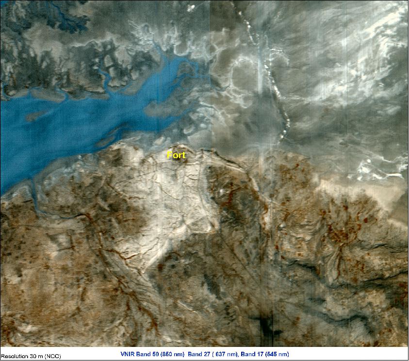
• December 2, 2018: The first light image from HySIS was acquired at NRSC (National Remote Sensing Center) Hyderabad, covering parts of Lakhpat in Gujarat, India. The sample color composite image represents VNIR spectral bands. 5)
• November 29, 2018: The HySIS minisatellite was launched at (04:28 UTC, 9:58 IST) on a PSLV-C43 vehicle from SDSC (Satish Dhawan Space Center) SHAR, on the east coast of India.
Sensor Complement
HysIS (Hyperspectral Imaging System)
HySIS carries two payloads — One to capture images in the VNIR (Visible Near Infrared) range of the light spectrum and another in the SWIR (Shortwave Infrared). The instrument uses the pushbroom technique featuring 60 spectral bands in VNIR (424 to 942 nm) with bandwidths of 10 nm and a spatial sampling of 30 m from a 636 km orbit. The SWIR sensor has a spectral resolution of 6.25 nm in the spectral wavelength range of 881 to 2473 nm, covering 256 spectral bands out of a total of 316 bands. 6) 7)
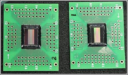
The optical imaging detector array chip in the satellite has been designed by ISRO's Ahmedabad-based SAC (Space Application Center) and manufactured by its SCL (Semi Conductor Limited), an autonomous body under the Department of Space in Chandigarh.
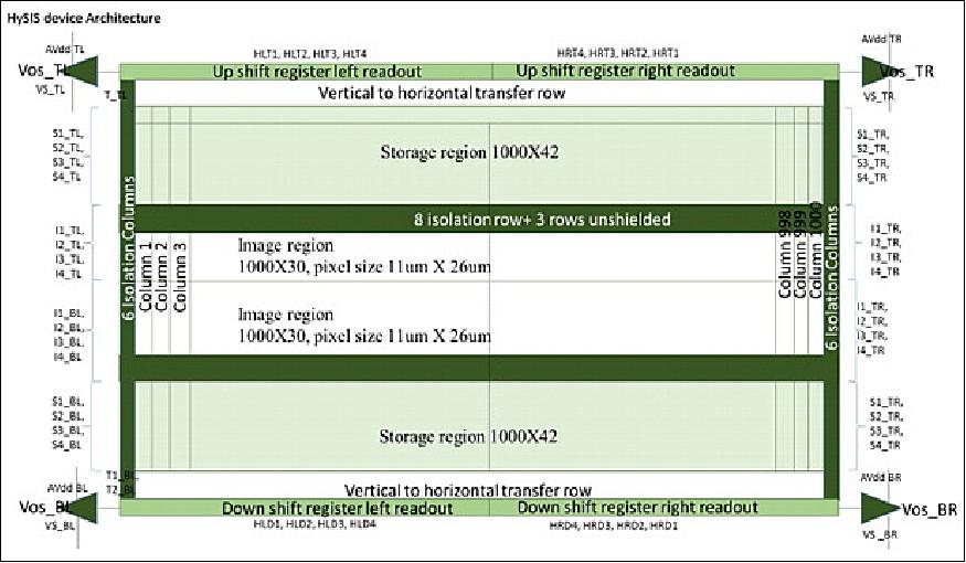
The chip architecture (Figure 8), device design,chip layout, and package design were carried out at SAC to meet project requirements with respect to spatial and temporal resolution, dynamic range, MTF (Modulation Transfer Function), smear and spectral responsivity. 1000 x 66 pixels were designed to be readout, from both top and bottom directions, using four analog video ports to meet the frame rate requirement. Metal strapping was used for swiftly transferring integrated charges from image to storage region, in order to reduce image smear. Designs (both at chip and package levels) went through detailed review, before clearing for mask making and package fabrication, by a team consisting of members from SCL and SAC.
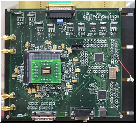
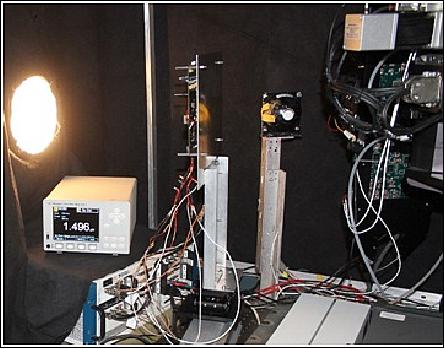
Wafer processing was completed at SCL with top priority. During wafer processing at SCL, the SAC team developed a test bench (hardware, firmware, and software for providing electro-optical stimuli) for electrooptical evaluation of the chip. Wafer level testing, assembly and packaging were carried out at SCL. Few dies were packaged (chip-on-board) at SCL for functionality verification.
The COB (Chip on Board) packages have successfully gone through functional verification checks at SAC. Figures 9, 10 and 11 are images of COB, test setup electronics, and EO test bench, respectively. Raw images generated under normal laboratory illumination conditions at F#2, a focal length of 105mm, and an integration time of 30 milliseconds and acquired by the chip, are given in Figures 12 and 13.


Automatic Labelling of Endmembers
Analysis of hyperspectral images requires identification of pure spectra termed as “end-members”. Endmembers identified from the image cube can be used for full pixel classification or abundance map generation representing the percentage of abundance of each material type present in every pixel.
Spectral libraries consisting of spectra for various features like vegetation, water body, soils, etc. are compiled from HySIS hyperspectral Surface Reflectance images covering different types of terrain and climatic conditions. Spectra of each end member is tied to the closest match from the library spectra.
The labelled end members shown in Figure 16 can be used to classify the input hyperspectral image (full-pixel, Figure 17, and sub-pixel Figure 18. 7)
The Advanced Data Processing Research Institute (ADRIN) has developed a methodology to automatically label endmembers.
The steps involved in automatic labelling of end members labelling is as shown in the Figure 14.

Most common and widely used library is the Advanced Space borne Thermal Emission and Reflection (ASTER) spectral library, which includes contributions from the Jet Propulsion Laboratory (JPL), Johns Hopkins University (JHU), and the United States Geological Survey (USGS).
The surface reflectance (SR) product is generated from input Hyperspectral DN image (with 316 bands) by customizing the 6S RT code, incorporating RSR of HySIS sensors. Atmospheric parameters available in the public domain are used for atmospheric correction. After removing atmospheric absorption bands, the SR product will have 246 bands. Which serve as input for generation of end members. SR product example is shown in Figure 15.


References
1) "ISRO launches HysIS satellite, 30 others with PSLV-C43 rocket today: Everything to know ," Indian Express, 29 November 2018, URL: https://indianexpress.com/article/technology/science/isro-launch-hysis-satellite-30-others-pslv-c43-rocket-5469076/
2) Upagrah Newsletter, Vol. 47, Issue 3, July-September 2018, URL: https://www.isac.gov.in/publications/upagrah/pdf/Upagrah-July-Sept2018.pdf
3) William Graham, "PSLV conducts HySIS launch with numerous co-passengers," NASA Spaceflight.com, 28 November 2018, URL: https://www.nasaspaceflight.com/2018/11/pslv-hysis-launch-numerous-co-passengers/
4) "Lift off for Pioneering nanosats," ESA, 29 November 2018, URL: http://m.esa.int/Our_Activities/Telecommunications_Integrated
_Applications/Lift_off_for_Pioneering_nanosats
5) "HYSIS First day Image," ISRO, 2 December 2018, URL: https://www.isro.gov.in/HYsIS_First_day_Image.html
6) "ISRO Develops Optical Imaging Detector Array for Hyperspectral Imaging Applications," ISRO, URL: https://web.archive.org/web/20170809134705/https://www.isro.gov.in/isro-develops-optical-imaging-detector-array-hyperspectral-imaging-applications
7) Sita D., Srinivas P., Kameswari Devi P., Mahalingam S., Radha Devi P. V., “Automatic Labelling of End Members Extracted from Hyperspectral Data”, Conference held on October 17-20, 2019, URL: https://ieeexplore.ieee.org/stamp/stamp.jsp?tp=&arnumber=8976050
Overview Spacecraft Launch Mission Status Sensor Complement References Back to top