ICON (Ionospheric Connection Explorer)
EO
Atmosphere
Atmospheric Temperature Fields
Operational (extended)
Quick facts
Overview
| Mission type | EO |
| Agency | UCB |
| Mission status | Operational (extended) |
| Launch date | 11 Oct 2019 |
| Measurement domain | Atmosphere |
| Measurement category | Atmospheric Temperature Fields, Atmospheric Humidity Fields, Atmospheric Winds |
| Instrument type | Space environment, Other, Atmospheric chemistry, Communications, Data collection, Atmospheric temperature and humidity sounders |
| CEOS EO Handbook | See ICON (Ionospheric Connection Explorer) summary |
ICON (Ionospheric Connection Explorer)
Spacecraft Launch Mission Status Sensor Complement Ground Segment References
In April 2013, NASA selected a new satellite mission and a new space-based instrument to begin development as part of the agency's Heliophysics Explorer Program. The projects will provide space observations to study Earth's ionosphere and thermosphere. NASA Selects Explorer Projects To Probe Earth's Upper Atmosphere 1) 2) 3) 4)
NASA awarded UCB (University of California, Berkeley) a contract to build a satellite to determine how Earth's weather affects weather at the edge of space, in hopes of improving forecasts of extreme "space weather". ICON will be designed, built and operated by scientists at UCB/SSL (Space Sciences Laboratory). 5) 6) 7)
Science: ICON will explore the boundary between Earth and space – the ionosphere – to understand the physical connection between our world and the immediate space environment around us. This region, where ionized plasma and neutral gas collide and react exhibits dramatic variability that affects space-based technological systems like GPS. The ionosphere has long been known to respond to "space weather" drivers from the sun, but recent NASA missions have surprised us in showing this variability often occurs in concert with weather on our planet. ICON will compare the impacts of these two drivers as they exert change on the space environment that surrounds us (Ref. 2).
We've known for many years that the Sun has a significant effect on this region of the upper atmosphere. As the Earth rotates, a new portion of its atmosphere is exposed to solar ultraviolet radiation, which heats and partially ionizes the neutral atoms and molecules, creating the ionosphere. At night, when that portion of the atmosphere is not exposed to the Sun, this ionized gas, or "plasma" tends to recombine, dramatically reducing its density as it converts back to an electrically neutral state. In between, near sunset, the low-latitude ionosphere is dominated by a "plasma fountain", which results in a dramatic upwelling of ionized gas. This results in a sharp increase of the density of ionized gas in narrow bands on either side of the magnetic equator. Basic models of the ionosphere predict that there should be a regular rise and fall of this portion of the atmosphere as the Earth rotates from day to night, independent of longitude. 8)

Understanding what is causing the variations in the atmosphere is very important in the technological era we live in today. As a society, we are very dependent on communication and navigation networks around the globe – both space based, and ground based. We have also recently developed a strong reliance on broadcast navigation signals such as those provided by GPS satellites. The radio signals used for communication and navigation must propagate through the ionosphere, and non-uniform distributions of plasma in the ionosphere can act like bubbles in a lens or scratches in a mirror, distorting the signal, sometimes to the point of unintelligibility or unusability.
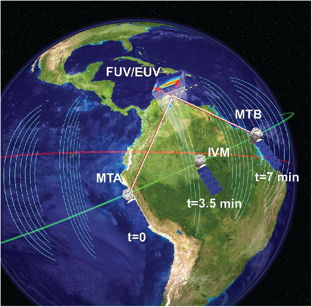
Though the solar inputs are now well quantified, the drivers of ionospheric variability originating from lower atmospheric regions are not. ICON is the first space mission to simultaneously retrieve all of the properties of the system that both influence and result from the dynamical and chemical coupling of the atmosphere and ionosphere. ICON achieves this through an innovative measurement technique that combines remote optical imaging and in situ measurements of the plasma. With this approach, ICON provides the ability to:
1) separate the drivers and pinpoint the real cause of ionospheric variability
2) explain how energy and momentum from the lower atmosphere propagate into the space environment
3) explain how these drivers set the stage for the extreme conditions of solar-driven magnetic storms.
ICON's imaging capability combined with its in-situ measurements on the same spacecraft (Figure 2) gives a perspective of the coupled system that would otherwise require two or more orbiting observatories.
ICON targets the low-latitude ionosphere because recent global-scale observations of this region show remarkable spatial and temporal variability that contravene the conventional view of ion-neutral coupling in space, and evince strong forcing by lower atmosphere drivers. The coupling of the atmosphere to space is strongest at these latitudes because the atmospheric waves are largest and so is the density of the space plasma, produced in abundance by the sun overhead and confined by the magnetic field.
The ICON mission is lead by Thomas J. Immel (PI) of UCB/SSL. The NASA Heliophysics Explorer mission, ICON, follows the PI-management mode of operation. The mission management is performed by UCB/SSL under the NASA/GSFC (Goddard Space Flight Center) Explorers program.
Spacecraft
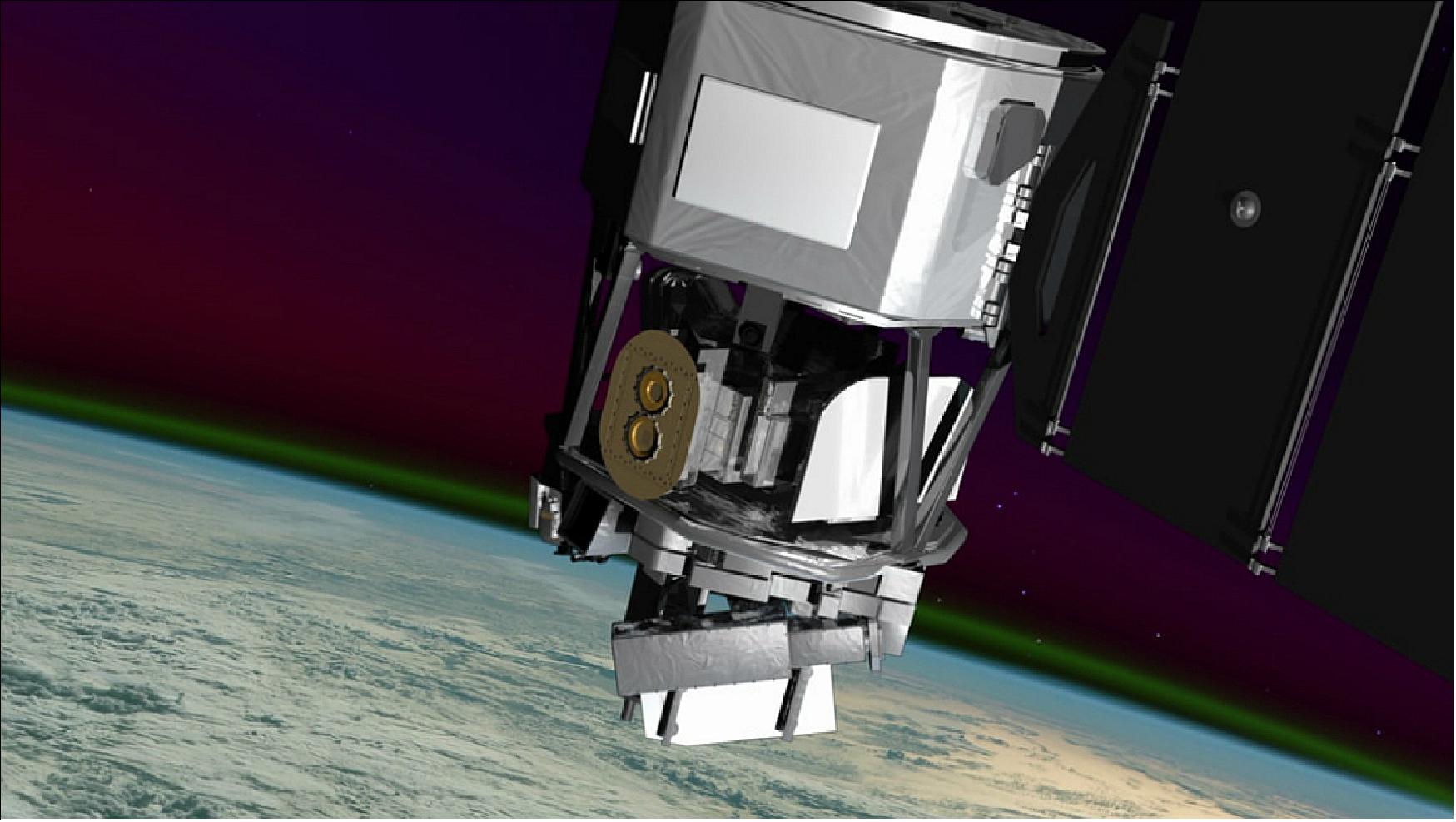
Orbital will design, manufacture and integrate the ICON spacecraft under contract from UCB/SSL. The LEOStar-2 platform of Orbital ATK was selected for the ICON spacecraft which is a flexible, high-performance spacecraft for space and Earth science, remote sensing and other applications. The LEOStar-2 series spacecraft have supported multiple missions for commercial and government customers over the past 15 years. ICON will be the ninth LEOStar-2-based spacecraft built by Orbital. 9) 10) 11)
ICON is a relatively straightforward application of the existing LEOStar-2 line. Attitude control is provided with a zero momentum bias system that includes actuators sized to perform all of ICON's attitude maneuvers for science. Two star trackers and an inertial measurement unit provide the information necessary to keep the instrument suite continually pointing at the Earth's limb as the observatory orbit the planet. This highly agile spacecraft generates ample electrical power using a two wing solar array design. A passive thermal control system maintains the spacecraft and instruments in their operational ranges.
Orbital's flight experience with single-string spacecraft such as ICON has been excellent, with most previous missions operating past their design lifetimes. The spacecraft also features selective component redundancy and an autonomous, flight proven fault management system to enhance reliability. The impressive past performance of the LEOStar-2 combined with high design margins early in development really helps ICON start with a low and manageable risk profile.
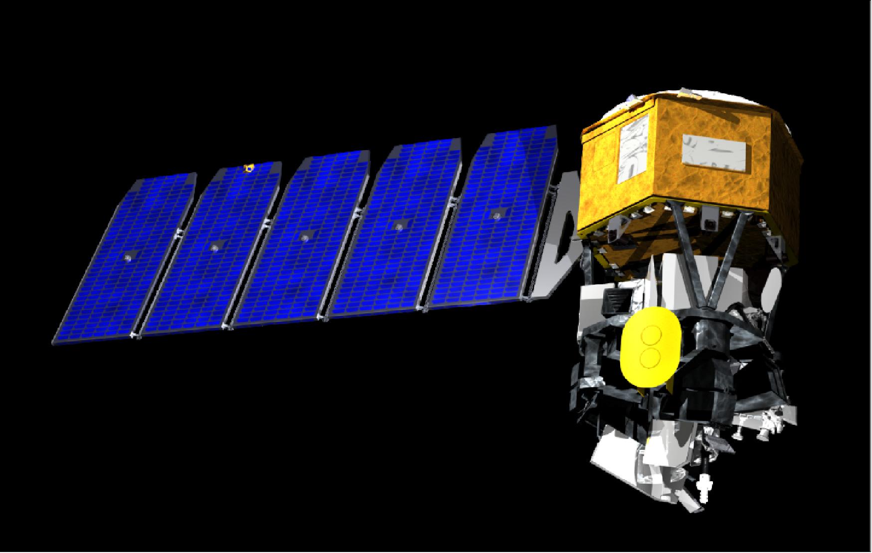
Spacecraft mass, power | ~272 kg; 780 W using articulated solar arrays, use of Li-ion battary |
Spacecraft redundancy | Single string |
Spacecraft stabilization | 3-axis stabilization, zero momentum bias |
Pointing | 144 arcsec control, 108 arcsec knowledge |
Avionics unit | Provides command, controlling and data handling of the observatory |
Onboard data storage | 16 Gbit |
Data downlink | S-band, 3.5 Mbit/s |
Mission design life | 2 years |
Project Development Status
• On Oct. 4, 2018, technicians at Vandenberg Air Force Base in California, installed the payload fairing on the Northrop Grumman Pegasus XL rocket that will launch NASA's Ionospheric Connection Explorer, or ICON, satellite. 12)
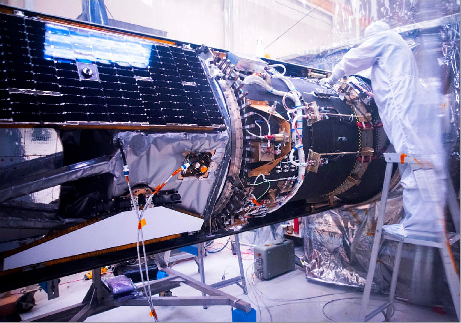
- ICON is being prepared for launch on a Pegasus XL rocket which will be carried aloft by Northrop Grumman's L-1011 Stargazer aircraft. The Stargazer with the Pegasus XL attached is scheduled to fly from Vandenberg, where it was processed, to the Skid Strip at Cape Canaveral Air Force Station in Florida on Oct. 19, 2018.
- Launch of the Pegasus XL rocket is scheduled for Oct. 26, 2018. The Stargazer jet will take off from the Skid Strip at the Cape. About 50 miles offshore of Daytona Beach, Florida, the Pegasus XL will be dropped with the engine igniting five seconds later boosting ICON to orbit. The Stargazer is a mobile launch platform and the only one of its kind in the world.
• On June 6, 2018, Northrop Grumman Corporation announced it has closed the acquisition of Orbital ATK Inc. ("Orbital ATK"), a global leader in aerospace and defense technologies. Orbital ATK is now Northrop Grumman Innovation Systems, a new, fourth business sector. 13)
• November 3, 2017: NASA is postponing launch of the Ionospheric Connection Explorer (ICON) until 2018. The mission was previously planned to launch Dec. 8, 2017, on an Orbital ATK Pegasus XL rocket from the Reagan Test Site on Kwajalein Atoll in the Marshall Islands. NASA and Orbital ATK need additional time to assess a separation component of the rocket. More information on a revised launch date will be provided once it becomes available. 14)
• April 7, 2016: All instruments were delivered in March to the SDL (Space Dynamics Laboratory) at USU (Utah State University) in Logan, where the instruments will be connected to the Payload Integration Plate — the common body of the spacecraft that will house the science payload. The integration and testing procedures are a vital part of preparing for flight, ensuring that they will function together as planned. 15)
- The I&T (Integration and Testing) processes for the ICON payload at USU/SDL are a vital part of preparing for flight. In order to ensure that the instruments will be able to function together as planned, they are brought together on the PIP (Payload Integration Plate). The PIP, the instruments, and the Instrument Control Package together become the science payload, which will then undergo a series of thorough vibration and thermal tests at SDL over the coming months. 16)
- Following I&T, the payload will be shipped from Utah to Orbital ATK in Virginia, where it will be integrated onto the main spacecraft "bus" - the guts of the satellite that controls communication, attitude, and other overall controls. This will happen towards the end of 2016, in preparation for launch in summer 2017.
• In November 2014, NASA has officially confirmed the ICON mission, clearing it to move forward into the development phase. 17)
• In July 2014, the ICON project passed its PDR (Preliminary Design Review). 18)
• On January 14, 2014, the ICON project passed the SRR (System Requirements Review). 19)
• In April 2013, UCB/SSL was selected to build NASA's next space weather satellite. 20)
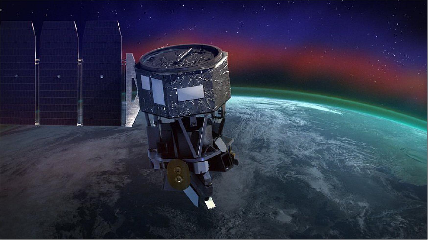
Launch
The ICON mission was launched on 11 October 2019 (02:00 UTC) aboard a Northrop Grumman Pegasus XL launch vehicle. The launch site was Cape Canaveral Air Force Station in Florida. ICON was air-launched over the Atlantic Ocean on a Northrop Grumman L-1011 aircraft, Stargazer. 21)
The spacecraft's solar panels successfully deployed, indicating it has power with all systems operating. After an approximately month-long commissioning period, ICON will begin sending back its first science data in November.
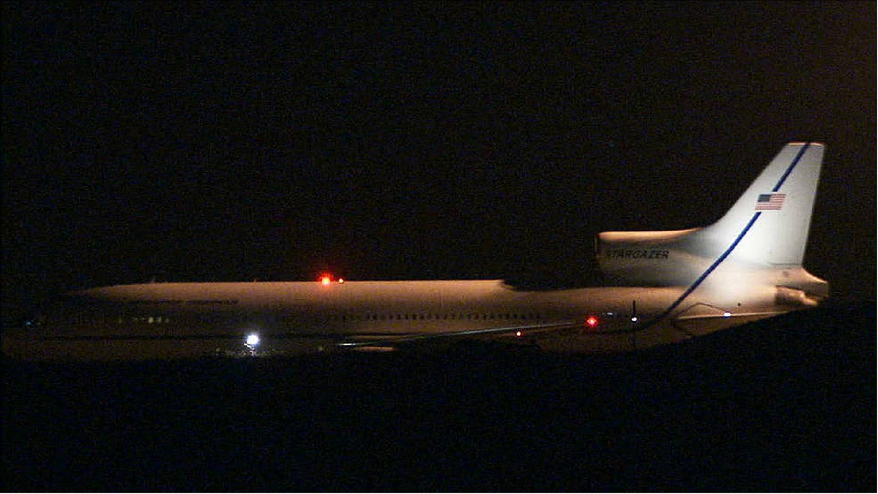
The launch was delayed from June 15, Nov. 14 and Dec. 8, 2017. 22) 23)
The launch attempt off Central Florida's east coast came after Northrop Grumman Innovation Systems (NGIS) conducted an extensive investigation and analysis of the Pegasus XL rocket to gather data following a continued, persistent issue with the launcher's actuator position in 2018.
Already in November 2014, NASA had selected Orbital Sciences Corporation of Dulles, Virginia, to provide launch services for the Ionospheric Connection Explorer (ICON) mission. ICON is targeted to launch in June 2017 from the Reagan Test Site on Kwajalein Atoll in the Republic of the Marshall Islands aboard a Pegasus XL launch vehicle from Orbital's "Stargazer" L-1011 aircraft. 24)
Orbit
Near-circular orbit, altitude = 579 km, inclination = 27º.
Mission Status
• May 10, 2022: When the Hunga Tonga-Hunga Ha‘apai volcano erupted on Jan. 15, 2022, it sent atmospheric shock waves, sonic booms, and tsunami waves around the world. Now, scientists are finding the volcano's effects also reached space. 25)
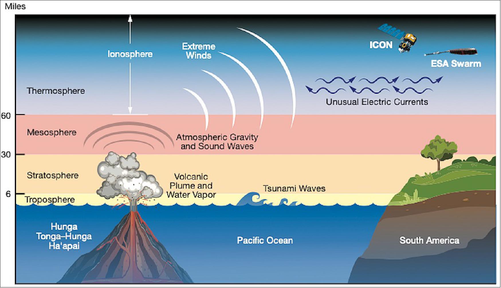
- Analyzing data from NASA's Ionospheric Connection Explorer, or ICON, mission and ESA's (European Space Agency) Swarm satellites, scientists found that in the hours after the eruption, hurricane-speed winds and unusual electric currents formed in the ionosphere – Earth's electrified upper atmospheric layer at the edge of space.
- "The volcano created one of the largest disturbances in space we've seen in the modern era," said Brian Harding, a physicist at University of California, Berkeley, and lead author on a new paper discussing the findings. "It is allowing us to test the poorly understood connection between the lower atmosphere and space."
- ICON launched in 2019 to identify how Earth's weather interacts with weather from space – a relatively new idea supplanting previous assumptions that only forces from the Sun and space could create weather at the edge of the ionosphere. In January 2022, as the spacecraft passed over South America, it observed one such earthly disturbance in the ionosphere triggered by the South Pacific volcano.
- "These results are an exciting look at how events on Earth can affect weather in space, in addition to space weather affecting Earth," said Jim Spann, space weather lead for NASA's Heliophysics Division at NASA Headquarters in Washington, D.C. "Understanding space weather holistically will ultimately help us mitigate its effects on society."

- When the volcano erupted, it pushed a giant plume of gases, water vapor, and dust into the sky. The explosion also created large pressure disturbances in the atmosphere, leading to strong winds. As the winds expanded upwards into thinner atmospheric layers, they began moving faster. Upon reaching the ionosphere and the edge of space, ICON clocked the windspeeds at up to 450 mph – making them the strongest winds below 120 miles altitude measured by the mission since its launch.
- In the ionosphere, the extreme winds also affected electric currents. Particles in the ionosphere regularly form an east-flowing electric current – called the equatorial electrojet – powered by winds in the lower atmosphere. After the eruption, the equatorial electrojet surged to five times its normal peak power and dramatically flipped direction, flowing westward for a short period.
- "It's very surprising to see the electrojet be greatly reversed by something that happened on Earth's surface," said Joanne Wu, a physicist at University of California, Berkeley, and co-author on the new study. "This is something we've only previously seen with strong geomagnetic storms, which are a form of weather in space caused by particles and radiation from the Sun."
- The new research, published in the journal Geophysical Research Letters, is adding to scientists' understanding of how the ionosphere is affected by events on the ground as well as from space. A strong equatorial electrojet is associated with redistribution of material in the ionosphere, which can disrupt GPS and radio signals that are transmitted through the region. 26)
- Understanding how this complex area of our atmosphere reacts in the face of strong forces from below and above is a key part of NASA research. NASA's upcoming Geospace Dynamics Constellation, or GDC, mission will use a fleet of small satellites, much like weather sensors on the ground, to track the electrical currents and atmospheric winds coursing through the area. By better understanding what affects electrical currents in the ionosphere, scientists can be more prepared to predict severe problems caused by such disturbances.
• November 29, 2021: What happens on Earth doesn't stay on Earth. — Using observations from NASA's ICON mission, scientists presented the first direct measurements of Earth's long-theorized dynamo on the edge of space: a wind-driven electrical generator that spans the globe 60-plus miles above our heads. The dynamo churns in the ionosphere, the electrically charged boundary between Earth and space. It's powered by tidal winds in the upper atmosphere that are faster than most hurricanes and rise from the lower atmosphere, creating an electrical environment that can affect satellites and technology on Earth. 27)
- The new work, published today in Nature Geoscience, improves our understanding of the ionosphere, which helps scientists better predict space weather and protect our technology from its effects. 28)
- Launched in 2019, ICON (Ionospheric Connection Explorer) is a mission to untangle how Earth's weather interacts with the weather in space. Radio and GPS signals zip through the ionosphere, which is home to auroras and the International Space Station. Empty pockets or dense swells of electrically charged particles can disrupt these signals.
- Scientists who study the atmosphere and space weather have long included Earth's dynamo in their models because they knew it had important effects. But with little information, they had to make some assumptions about how it works. Data from ICON is the first concrete observation of winds fueling the dynamo, eventually influencing space weather, to feed into those models.
- "ICON's first year in space has shown predicting these winds is key to improving our ability to predict what happens in the ionosphere," said Thomas Immel, ICON principal investigator at University of California, Berkeley, and lead author of the new study.
Earth's Sky-High Generator
- The ionosphere is like a sloshing sea of electrically charged particles, created by the Sun and intermixed with the neutral upper atmosphere. Sandwiched between Earth and space, the ionosphere responds to changes from both the Sun above and Earth below. How much influence comes from each side is what researchers are interested in figuring out. Studying a year of ICON data, the researchers found much of the change they observed originated in the lower atmosphere.
- Generators work by repeatedly moving an electricity-carrying conductor — like a copper wire — through a magnetic field. Filled with electrically charged gases called plasma, the ionosphere acts like a wire, or rather, a tangled mess of wires: Electricity flows right through. Like the dynamo in Earth's core, the dynamo in the atmosphere produces electromagnetic fields from motion.
- Strong winds in the thermosphere, a layer of the upper atmosphere known for its high temperatures, push current-carrying plasma in the ionosphere across invisible magnetic field lines that arc around Earth like an onion. The wind tends to push on chunky, positively charged particles more than small, negatively charged electrons. "You get pluses moving differently than minuses," said co-author Brian Harding, a physicist at University of California, Berkeley. "That's an electric current."

- In most generators, these components are bound tightly so they stay put and act predictably. But the ionosphere is free to move however it likes. "The current generates its own magnetic field, which fights Earth's magnetic field as it's passing through," Immel said. "So you end up with a wire trying to get away from you. It's a messy generator."
- Following the whims of the ionosphere is key to predicting space weather's potential impacts. Depending on which way the wind blows, plasma in the ionosphere shoots out into space or plummets toward Earth. This behavior results from the tug-of-war between the ionosphere and Earth's electromagnetic fields.
- The dynamo, which lies at the lower end of the ionosphere, has remained a mystery for so long because it's difficult to observe. Too high for scientific balloons and too low for satellites, it has eluded many of the tools researchers have to study near-Earth space. ICON is uniquely equipped to investigate this part of the ionosphere from above by taking advantage of the upper atmosphere's natural glow to detect the motion of plasma.
- ICON simultaneously observes powerful winds and migrating plasma. "This was the first time we could tell how much the wind contributes to the ionosphere's behavior, without any assumptions," said Astrid Maute, another study co-author and ICON scientist at the National Center for Atmospheric Research in Boulder, Colorado.
- Only in the past decade or so, Immel said, have scientists realized just how much those rising winds vary. "The upper atmosphere wasn't expected to change rapidly," he said. "But it does, day to day. We're finding this is all due to changes driven up from the lower atmosphere."
Wind Power
- Familiar are the winds that skim the surface of Earth, from gentle breezes to bracing gusts that blow one way and then the other.
- High-altitude winds are a different beast. From 60 to 95 miles above the ground, in the lower thermosphere, winds can blast in the same direction at the same speed — around 250 mph — for a few hours at a time before suddenly reversing direction. (By comparison, winds in the strongest Category 5 hurricanes tear at 157 mph or more.)
- These dramatic shifts are the result of waves of air, called tides, born at Earth's surface when the lower atmosphere heats up during the day then cools down at night. They surge through the sky daily, carrying changes from below.
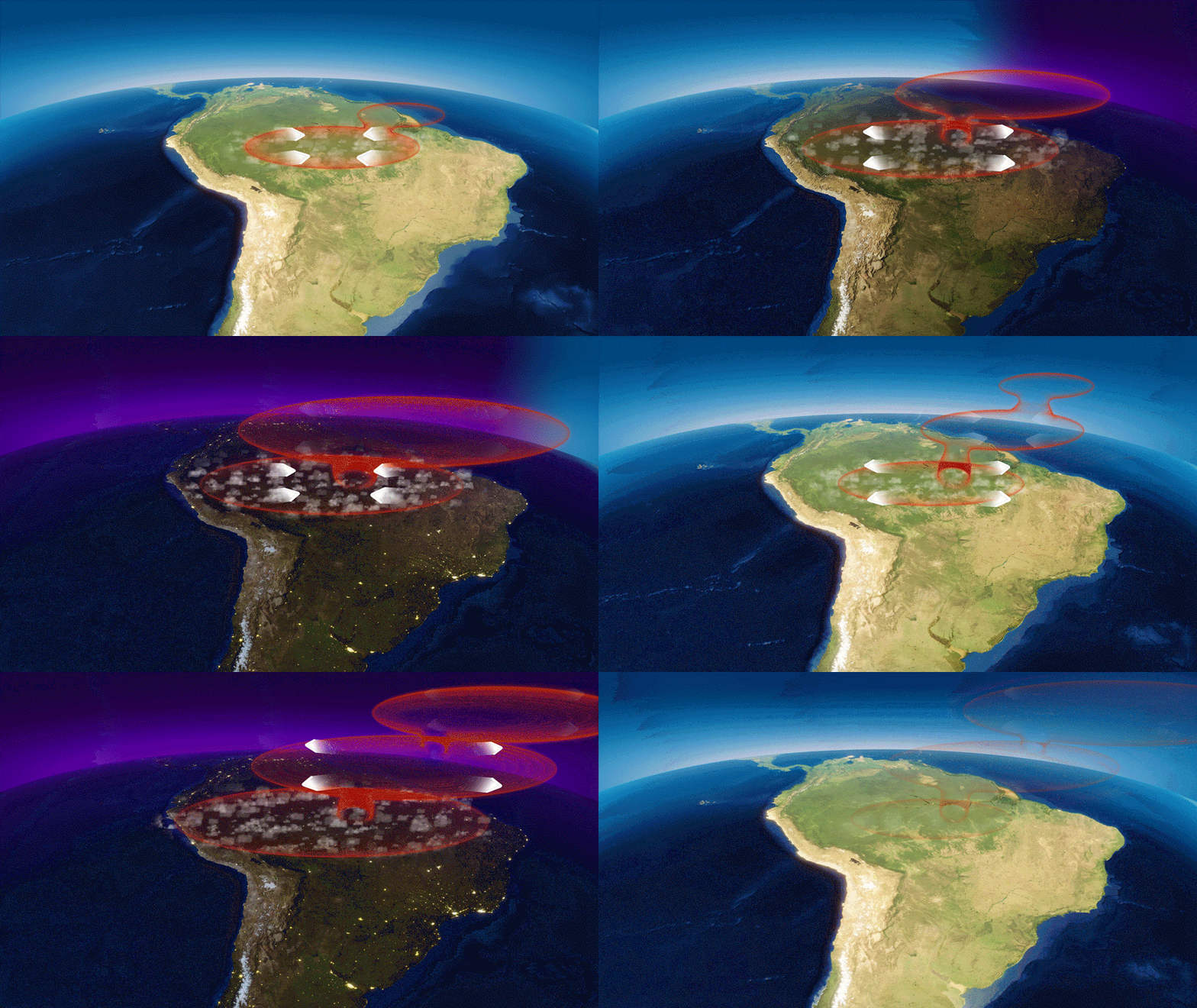
- The farther the atmosphere stretches away from the surface, the thinner it becomes and the less turbulence there is to disrupt these motions. That means small tides generated near the surface can grow much larger when they reach the upper atmosphere. "Changes in the winds up there are mostly controlled by what happens below," Harding said.
- ICON's new wind measurements help scientists understand these tidal patterns that span the globe and their effects.
- Tides ripple up through the sky, building in strength and growing before gusting through the ionosphere. The electric dynamo whirs in response.
- The scientists analyzed the first year of ICON data, and found high-altitude winds strongly influence the ionosphere. "We traced the pattern of how the ionosphere moves, and there was a clear wave-like structure," Harding said. Changes in the wind, he explained, directly corresponded to the dance of plasma 370 miles above Earth's surface.
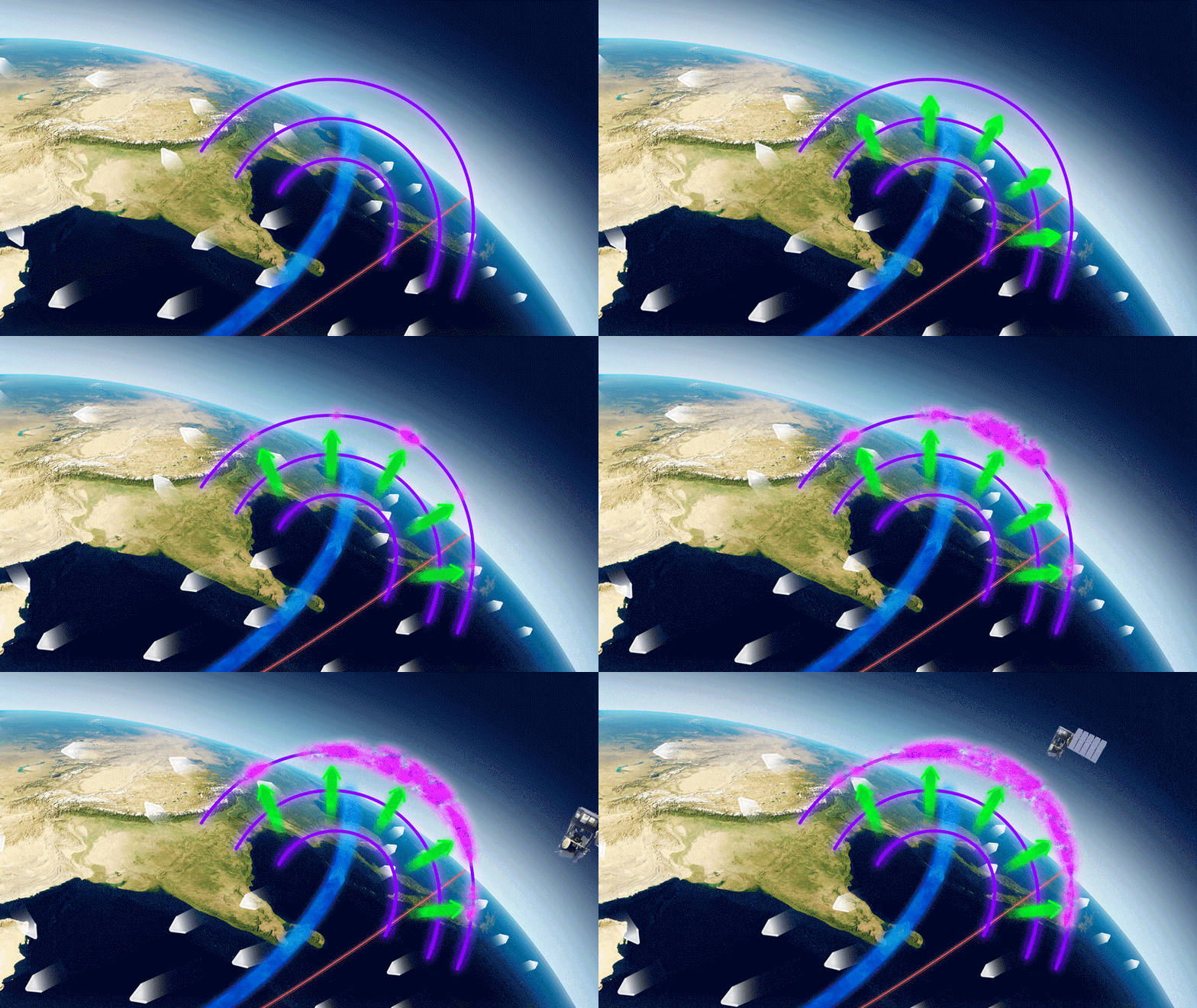
- "Half of the motion of the plasma can be attributed to the winds that we observe right there on that same magnetic field line," Immel said. "That tells you it's an important observation to make if you want to predict what plasma is doing."
- ICON's first year of observations coincided with solar minimum, the quiet phase of the Sun's 11-year activity cycle. During this time, the Sun's behavior was a low, constant hum. "We know the Sun's not doing much, but we saw a lot of variability from below, and then remarkable changes in the ionosphere," Immel said. That told the researchers they could rule out the Sun as the main influence.
- As the Sun ramps up to its active phase, scientists will be able to study more complex changes and interactions between space and Earth's atmosphere.
- Immel said he is excited to have this confirmation of long-held ionosphere theories. "We found half of what causes the ionosphere to behave as it does right there in the data," he said. "This is what we wanted to know."
- Still, Maute said, "This leaves room to explore what else is contributing to the ionosphere's behavior."
• August 17, 2020: A small but evolving dent in Earth's magnetic field can cause big headaches for satellites. 29)
- Earth's magnetic field acts like a protective shield around the planet, repelling and trapping charged particles from the Sun. But over South America and the southern Atlantic Ocean, an unusually weak spot in the field – called the SAA (South Atlantic Anomaly) – allows these particles to dip closer to the surface than normal. Particle radiation in this region can knock out onboard computers and interfere with the data collection of satellites that pass through it – a key reason why NASA scientists want to track and study the anomaly.
- The South Atlantic Anomaly is also of interest to NASA's Earth scientists who monitor the changes in magnetic field strength there, both for how such changes affect Earth's atmosphere and as an indicator of what's happening to Earth's magnetic fields, deep inside the globe.
- Currently, the SAA creates no visible impacts on daily life on the surface. However, recent observations and forecasts show that the region is expanding westward and continuing to weaken in intensity. It is also splitting – recent data shows the anomaly's valley, or region of minimum field strength, has split into two lobes, creating additional challenges for satellite missions.
- A host of NASA scientists in geomagnetic, geophysics, and heliophysics research groups observe and model the SAA, to monitor and predict future changes – and help prepare for future challenges to satellites and humans in space.
It's What's Inside that Counts
- The South Atlantic Anomaly arises from two features of Earth's core: The tilt of its magnetic axis, and the flow of molten metals within its outer core.
- Earth is a bit like a bar magnet, with north and south poles that represent opposing magnetic polarities and invisible magnetic field lines encircling the planet between them. But unlike a bar magnet, the core magnetic field is not perfectly aligned through the globe, nor is it perfectly stable. That's because the field originates from Earth's outer core: molten, iron-rich and in vigorous motion 1800 miles below the surface. These churning metals act like a massive generator, called the geodynamo, creating electric currents that produce the magnetic field.
- As the core motion changes over time, due to complex geodynamic conditions within the core and at the boundary with the solid mantle up above, the magnetic field fluctuates in space and time too. These dynamical processes in the core ripple outward to the magnetic field surrounding the planet, generating the SAA and other features in the near-Earth environment – including the tilt and drift of the magnetic poles, which are moving over time. These evolutions in the field, which happen on a similar time scale to the convection of metals in the outer core, provide scientists with new clues to help them unravel the core dynamics that drive the geodynamo.
- "The magnetic field is actually a superposition of fields from many current sources," said Terry Sabaka, a geophysicist at NASA's Goddard Space Flight Center in Greenbelt, Maryland. Regions outside of the solid Earth also contribute to the observed magnetic field. However, he said, the bulk of the field comes from the core.
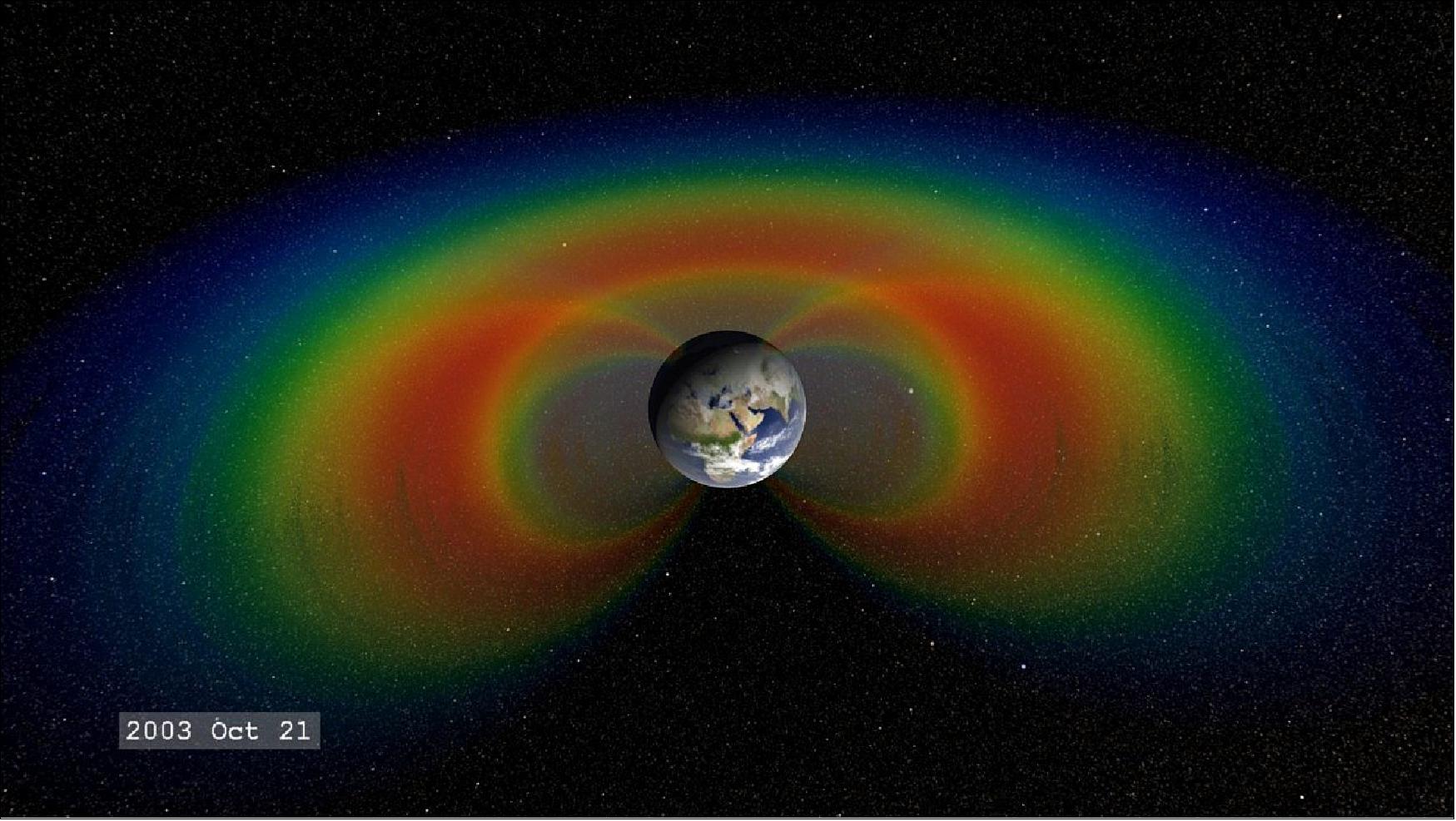
- The Sun expels a constant outflow of particles and magnetic fields known as the solar wind and vast clouds of hot plasma and radiation called coronal mass ejections. When this solar material streams across space and strikes Earth's magnetosphere, the space occupied by Earth's magnetic field, it can become trapped and held in two donut-shaped belts around the planet called the Van Allen Belts. The belts restrain the particles to travel along Earth's magnetic field lines, continually bouncing back and forth from pole to pole. The innermost belt begins about 400 miles from the surface of Earth, which keeps its particle radiation a healthy distance from Earth and its orbiting satellites.
- However, when a particularly strong storm of particles from the Sun reaches Earth, the Van Allen belts can become highly energized and the magnetic field can be deformed, allowing the charged particles to penetrate the atmosphere.
- "The observed SAA can be also interpreted as a consequence of weakening dominance of the dipole field in the region," said Weijia Kuang, a geophysicist and mathematician in Goddard's Geodesy and Geophysics Laboratory. "More specifically, a localized field with reversed polarity grows strongly in the SAA region, thus making the field intensity very weak, weaker than that of the surrounding regions."
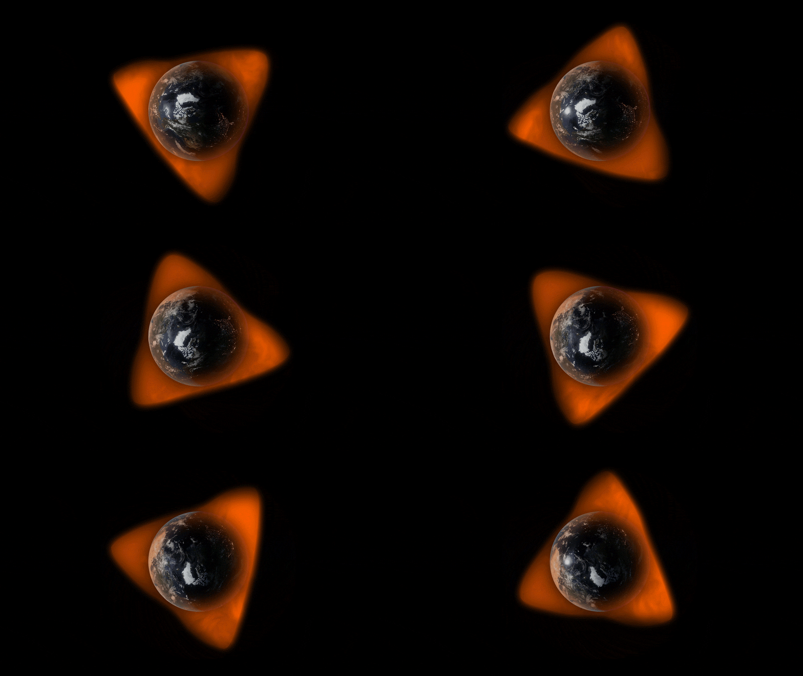
A Pothole in Space
- Although the South Atlantic Anomaly arises from processes inside Earth, it has effects that reach far beyond Earth's surface. The region can be hazardous for low-Earth orbit satellites that travel through it. If a satellite is hit by a high-energy proton, it can short-circuit and cause an event called single event upset or SEU. This can cause the satellite's function to glitch temporarily or can cause permanent damage if a key component is hit. In order to avoid losing instruments or an entire satellite, operators commonly shut down non-essential components as they pass through the SAA. Indeed, NASA's Ionospheric Connection Explorer regularly travels through the region and so the mission keeps constant tabs on the SAA's position.
- The International Space Station, which is in low-Earth orbit, also passes through the SAA. It is well protected, and astronauts are safe from harm while inside. However, the ISS has other passengers affected by the higher radiation levels: Instruments like the GEDI (Global Ecosystem Dynamics Investigation) mission, collect data from various positions on the outside of the ISS. The SAA causes "blips" on GEDI's detectors and resets the instrument's power boards about once a month, said Bryan Blair, the mission's deputy principal investigator and instrument scientist, and a lidar instrument scientist at Goddard.
- "These events cause no harm to GEDI," Blair said. "The detector blips are rare compared to the number of laser shots – about one blip in a million shots – and the reset line event causes a couple of hours of lost data, but it only happens every month or so."
- In addition to measuring the SAA's magnetic field strength, NASA scientists have also studied the particle radiation in the region with the SAMPEX (Solar, Anomalous, and Magnetospheric Particle Explorer) – the first of NASA's Small Explorer missions, launched in 1992 and providing observations until 2012. One study, led by NASA heliophysicist Ashley Greeley as part of her doctoral thesis, used two decades of data from SAMPEX to show that the SAA is slowly but steadily drifting in a northwesterly direction. The results helped confirm models created from geomagnetic measurements and showed how the SAA's location changes as the geomagnetic field evolves.
- "These particles are intimately associated with the magnetic field, which guides their motions," said Shri Kanekal, a researcher in the Heliospheric Physics Laboratory at NASA Goddard. "Therefore, any knowledge of particles gives you information on the geomagnetic field as well."
- Greeley's results, published in the journal Space Weather, were also able to provide a clear picture of the type and amount of particle radiation satellites receive when passing through the SAA, which emphasized the need for continuing monitoring in the region.
- he information Greeley and her collaborators garnered from SAMPEX's in-situ measurements has also been useful for satellite design. Engineers for the Low-Earth Orbit, or LEO, satellite used the results to design systems that would prevent a latch-up event from causing failure or loss of the spacecraft.
Modeling a Safer Future for Satellites
- In order to understand how the SAA is changing and to prepare for future threats to satellites and instruments, Sabaka, Kuang and their colleagues use observations and physics to contribute to global models of Earth's magnetic field.
- The team assesses the current state of the magnetic field using data from the European Space Agency's Swarm constellation, previous missions from agencies around the world, and ground measurements. Sabaka's team teases apart the observational data to separate out its source before passing it on to Kuang's team. They combine the sorted data from Sabaka's team with their core dynamics model to forecast geomagnetic secular variation (rapid changes in the magnetic field) into the future.
- The geodynamo models are unique in their ability to use core physics to create near-future forecasts, said Andrew Tangborn, a mathematician in Goddard's Planetary Geodynamics Laboratory.
- "This is similar to how weather forecasts are produced, but we are working with much longer time scales," he said. "This is the fundamental difference between what we do at Goddard and most other research groups modeling changes in Earth's magnetic field."
- One such application that Sabaka and Kuang have contributed to is the IGRF (International Geomagnetic Reference Field). Used for a variety of research from the core to the boundaries of the atmosphere, the IGRF is a collection of candidate models made by worldwide research teams that describe Earth's magnetic field and track how it changes in time.
- "Even though the SAA is slow-moving, it is going through some change in morphology, so it's also important that we keep observing it by having continued missions," Sabaka said. "Because that's what helps us make models and predictions."
- The changing SAA provides researchers new opportunities to understand Earth's core, and how its dynamics influence other aspects of the Earth system, said Kuang. By tracking this slowly evolving "dent" in the magnetic field, researchers can better understand the way our planet is changing and help prepare for a safer future for satellites.
• June 22, 2020: On June 22, NASA's ICON team released scientific data collected during the spacecraft's first eight months in orbit to the public. 30)
- The data release features observations from ICON's four instruments — MIGHTI, FUV, EUV, and IVM — which have been observing the ins and outs of the ionosphere, the sea of charged particles high in the upper atmosphere. Scientists have been busy parsing the wealth of observations collected by ICON in preparation for the mission's first science results, which will be released later this year.
- "ICON was designed, built, and launched to provide data we had never seen before, and it has not disappointed us in any regard," said Thomas Immel, ICON principal investigator at University of California, Berkeley. Immel said he was pleased to share ICON's first data with the world. "The sensitivity and precision of our observations, and the unique orbit and mission design, give us a new and advanced tool for unlocking all the puzzling questions we have had about the connection between Earth's atmosphere and our space environment."
- The release coincides with the virtual summer meeting of CEDAR, the Coupling, Energetics, and Dynamics of Atmospheric Regions program. The newly released data spans measurements made since the mission's launch on Oct. 10, 2019. Data can be accessed through University of California Berkeley's Space Sciences Lab.
- ICON observes what's happening at the lowest boundary of space, from about 55 miles up to 360 miles above the surface. ICON explores the connections between the neutral atmosphere and the electrically charged ionosphere. In addition to interfering with communications signals, space weather in this important slice of the atmosphere can also prematurely decay spacecraft orbits and expose astronauts to radiation-borne health risks.
- "We're really excited to see the first data appearing from the ICON mission," said Scott England, the ICON project scientist at Virginia Tech in Blacksburg, Virginia. "For me, the real power of these data isn't just seeing transformative things like the wind patterns throughout the whole upper atmosphere, but having all these observations available to us at once, so we can see the connections between the neutral and charged environment around Earth."
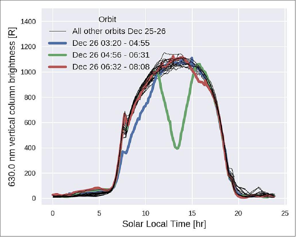
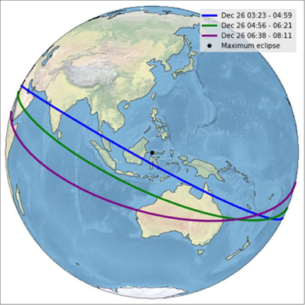
• February 20, 2020: Just over six weeks after launch and early calibrations, NASA's Ionospheric Connection Explorer (ICON) mission was presented with a unique opportunity. ICON flew very close to the December 26 solar eclipse track that extended across Asia, and observed the major changes in upper atmospheric airglow that naturally occurred. ICON's four instruments, primed to look at the ionosphere, the dynamic region where Earth meets space, were in position to observe the effects. What happens when airglow –the natural glow of Earth's atmosphere caused by solar radiation – is temporarily "turned off" when the sun is blocked by the moon's shadow for a few minutes? Preliminary data shows that all four instruments – MIGHTI, EUV, FUV and IVM – were able to see changes the eclipse wrought. 31)
- The Michelson Interferometer for Global High-resolution Thermospheric Imaging (MIGHTI) tracks red and green airglow 100 km above the Earth's surface to measure how the neutral atmosphere moves. MIGHTI looked for the cold spot caused by the moon's shadow that puts the atmosphere in motion and generates a planetary-scale wave. Such a wave was observed during the 2017 Great American Eclipse.
- A simple view of MIGHTI's data shows the effect on the airglow brightness. Further analysis will provide associated changes in thermospheric winds and temperatures.
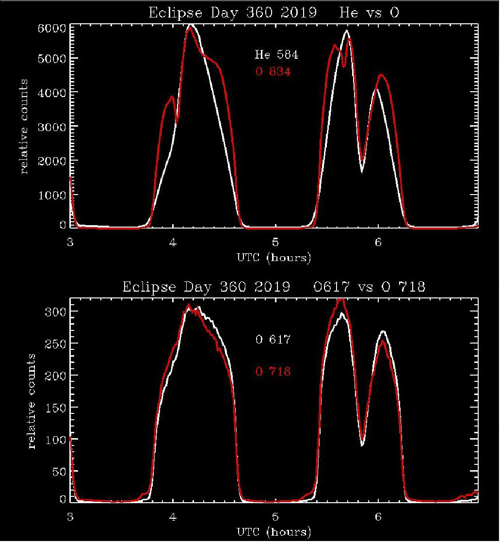
- ICON was observing Earth's extreme ultraviolet dayglow, itself produced by solar ultraviolet radiation, as it was affected by moon's shadow during the eclipse. Shown below are data from successive orbits of EUV, the Extreme Ultraviolet instrument. The plot shows that the brightness dropped very rapidly from maximum down to 40% in just nine minutes. ICON EUV measures several different wavelengths in the extreme-UV range, and these behaved a bit differently because of the physics of the atmosphere at different altitudes where the emission is produced.
- ICON's FUV (Far Ultraviolet) instrument is looking at the height and density of the daytime upper atmosphere. FUV also measured the daytime far ultraviolet emissions during the eclipse as they were affected in a way similar to EUV. During the normal midday peak in the eclipse, the brightness dropped very rapidly to 30% of its normal daytime value, and the nitrogen emission dropped even more, to 22% of the daytime value.
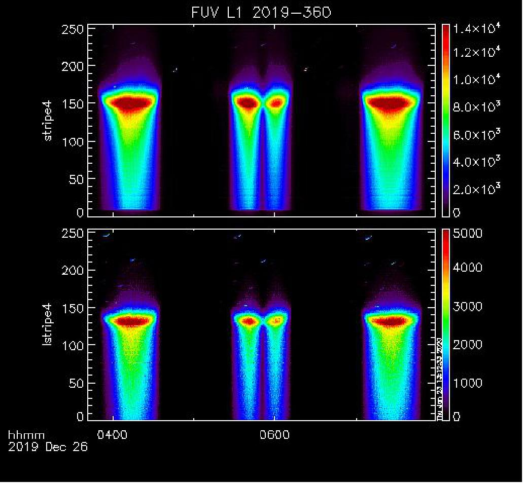
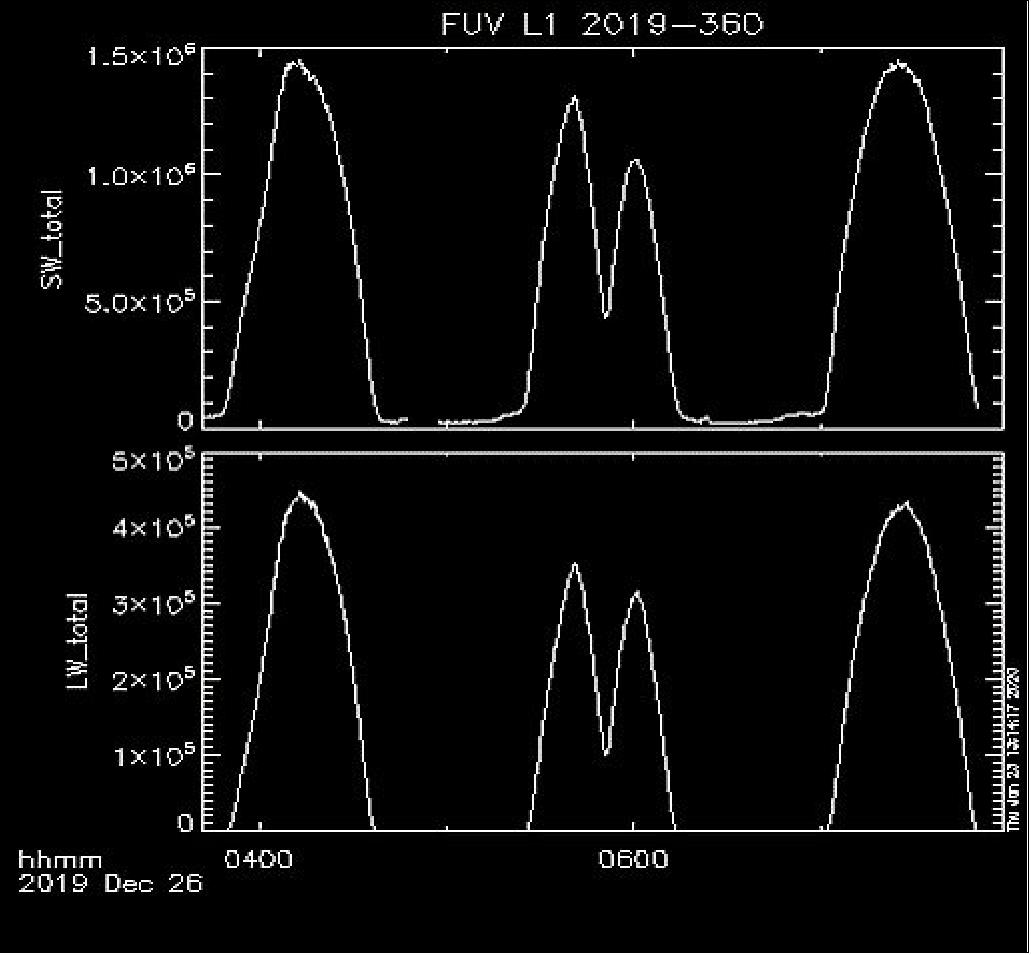
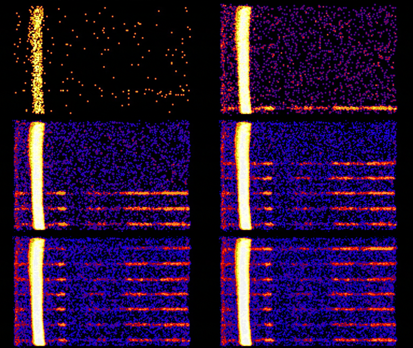
- The movie (Figure 23) of the six altitude profiles from FUV shows the increasing brightness when the spacecraft moves from the night side to the dayside where the solar extreme ultraviolet light ultimately produces the airglow emission from oxygen (left) and nitrogen (right). Around 5:44, the observed area comes to the shadow region from the eclipse and the airglow brightness drops to its minimum at 5:51. When the viewed area leaves the shadow region the brightness increases again until the instrument sees the evening region and moves into the night.
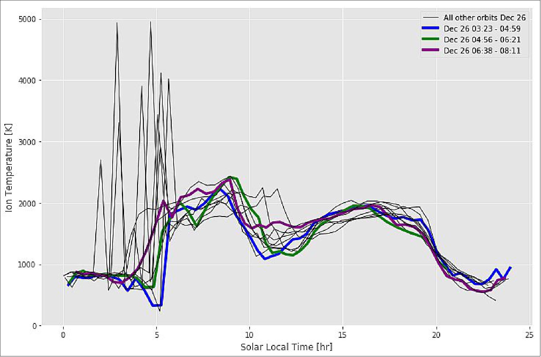
- The IVM (Ion Velocity Meter) measures the temperature of the charged particles around the Earth. These charged particles are produced when sunlight hits the atmosphere. However, IVM's data from the orbit with the eclipse does not show a major change in the temperature compared to the previous or next orbits, suggesting that the ionosphere at 585 km is not rapidly affected like the dayglow seen nearer 200 km altitude.
- It is likely that the ionospheric effects far from the eclipse are quite different and possibly much larger than the effects at the eclipse location. This is because of the connection between the dynamical response to the eclipse, carrying the effect across the planet in atmospheric waves.
- ICON will be making observations over the next two years, greatly increasing our understanding of this relatively unexplored region between Earth and space, and of its potential for impact on communications and GPS, space weather prediction, and protection of our space assets from radiation. Look for more remarkable results from the ICON science team here soon!
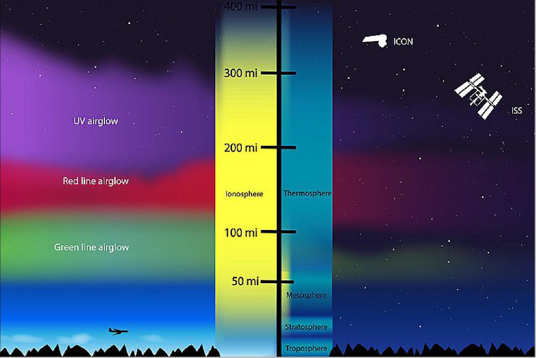
• January 7, 2020: Between 80 and 600 km (50 and 400 miles) above the ground, radiation from the Sun cooks the gases in our upper atmosphere until they lose electrons. The result is a sea of electrically charged particles—ions—intermingled with the neutral upper atmosphere. The visible expressions of this energy flow are auroras and airglow. 32)
- Airglow typically appears in thin layers of red, green, purple, or yellow light when looking toward the limb of Earth and edge-on into our upper atmosphere. Airglow occurs when atoms and molecules, excited by sunlight, emit light to shed their excess energy. It also can form when atoms and molecules that have been ionized by sunlight collide with and capture a free electron. In both cases, they eject a particle of light (a photon) in order to relax again. Each atmospheric gas has a dominant airglow color that depends on the gas, the altitude, and the excitation process.
- Unlike auroras, which are episodic and fleeting, airglow shines almost constantly. Just a tenth as bright as all the stars in the night sky, airglow is hard to observe except from orbit or from the ground with clear, dark skies and a sensitive camera. Airglow carries information about the temperature, density, and composition of the upper atmosphere, and also helps us trace how particles move through the region.
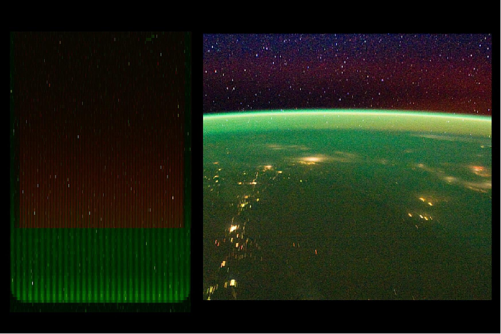
- The Ionospheric Connection Explorer (ICON) was launched in October 2019 to study the uppermost reaches of the atmosphere, particularly airglow. After several weeks of spacecraft maneuvers, tests, and calibration, ICON began taking science data on December 1. Thomas Immel, principal investigator and a scientist at the University of California, Berkeley, presented the first images (Figures 26 and 27) in mid-December 2019.
- Observations from ICON are designed to complement global views of the ionosphere as observed by the GOLD (Global-scale Observations of the Limb and Disk) instrument on a geostationary satellite. The relationship between the two ionospheric missions could be likened to photography. If GOLD captures landscapes from 22,000 miles above Earth, ICON (at just 360 miles) specializes in detailed close-ups. During certain parts of its orbit, ICON passes through GOLD's field of view, giving each mission a snapshot of the same region and events from different perspectives.
Image credit: The NASA images/videos above are courtesy of ICON/Harald Frey/Thomas Bridgman and ICON/Christoph Englert/Joy Ng. Airglow video from the ISS Crew Earth Observations Facility and the Earth Science and Remote Sensing Unit, Johnson Space Center. Story by Lina Tran, NASA Goddard Space Flight Center, with Mike Carlowicz.
• In a December 10, 2019 press event at the fall meeting of the American Geophysical Union in San Francisco, three scientists presented new images of the ionosphere, the dynamic region where Earth's atmosphere meets space. Home to astronauts and everyday technology like radio and GPS, the ionosphere constantly responds to changes from space above and Earth below. 33)
- The collection of images presented include the first images from NASA's ICON, new science results from NASA's GOLD, and observations of a fleeting, never-before-studied aurora. Together, they bring color to invisible processes that have widespread implications for the part of space that is closest to home.
- Earth's ionosphere stretches from 50 to 400 miles above the ground and overlaps the top of the atmosphere and the very beginning of space. Radiation from the Sun cooks a small portion of gases in the upper atmosphere until they lose an electron or two. The result: a sea of electrically charged particles intermingled with the neutral upper atmosphere.
- Besides energy streaming in from the Sun and near-Earth space, the ionosphere also responds to weather patterns that ripple up from the lower atmosphere below. These changes — which can impact astronauts and key communications systems — are complex and unpredictable. A range of specialized instruments is key to studying and understanding them.
First Light ICON Images
- ICON is well-positioned to investigate the variability GOLD has uncovered. - We have a mission to explore day-to-day variability just like GOLD is showing," said Thomas Immel, ICON principal investigator at University of California, Berkeley. "ICON is built to explore this region of space and try to capture all that could be influencing the ionosphere this way."
- The relationship between NASA's two ionospheric missions could be likened to photography: If GOLD captures landscapes from 22,000 miles above Earth, ICON — at just 360 miles — specializes in detailed close-ups. During certain parts of its orbit, ICON passes through GOLD's field of view and each mission can get a snapshot of the same region, from their own unique perspectives. This overlap makes it easier to identify what caused a certain change to the upper atmosphere at a given time.
- ICON launched on Oct.10, 2019, and began science mode on Dec. 1. Thomas Immel presented the first images the spacecraft took during its commissioning and calibration period, demonstrating the capabilities of ICON's instruments and presenting a taste of what the scientists hope to observe.
- ICON carries three imagers that survey airglow, the natural glow of Earth's atmosphere caused by solar radiation. Each atmospheric gas has its own favored airglow color depending on the gas, altitude region and excitation process, so scientists can use airglow to study where these gases are and how they behave.
- Two instruments view airglow in ultraviolet. The EUV (Extreme Ultraviolet) instrument depends upon accurately measuring the light from glowing oxygen in order to track the height and density of the daytime ionosphere. Because the team had never made these measurements in orbit before, they calibrated their instrument on a known source: the Moon.
- The FUV (Far Ultraviolet) instrument takes images in the same wavelength as GOLD (Global-scale Observations of the Limb and Disk). At night, it measures the density of the ionosphere, and during the day, composition. Immel said the images remind him of the window view from an airplane — 360 miles above the surface and in ultraviolet light.
- "The first thing we see is a bit boring, but I'm excited nevertheless," Immel said. "It's exactly what you would expect if the instrument were working perfectly." Now that ICON has undergone its extensive instrument checks, the scientists can begin looking for the ionosphere's more interesting quirks.

- ICON's last imager is MIGHTI (Michelson Interferometer for Global High-resolution Thermospheric Imaging). MIGHTI tracks red and green oxygen airglow to measure how the neutral atmosphere moves, which scientists think plays a role in the ionosphere's daily changes. There is a black fringe pattern laid over the MIGHTI images; the magic, Immel said, happens between the lines. By measuring how airglow moves against the black lines, scientists can read the motions, or the winds, of the upper atmosphere.
- "With all these different data products, we're going to make great strides in answering the questions GOLD has raised for us," Immel said.
• October 24, 2019: As of today, ICON has been in space for two weeks since its launch from Cape Canaveral on October 10, 2019, and we're pleased to report that the observatory is performing well. 34)
- Here in the UCB Mission Operations Center, ICON's commissioning has started, and all spacecraft functions—such as power generation, thermal and pointing control and maneuvering—have been successfully tested. We're learning some things you can only learn on orbit, but the Northrop Grumman spacecraft seems to be in great shape and ready for science. The commissioning of ICON's four instruments has started and will continue through November. All instruments have been turned on electrically and checked out. Two of the four instruments, IVM and MIGHTI, even received their first data. The MIGHTI instrument looks to be operating perfectly, producing interferograms that are exactly as we hoped. The other two instruments, EUV and FUV, will open their doors around Halloween, and then the high voltage will be ramped up. We're working all day, but the observatory is monitored around the clock by flight controllers and engineers.
- An anniversary can also be celebrated—our 11-meter satellite dish is located on the grounds of Space Sciences Lab and used for two-way communication with ICON and other satellites within range. It is known as the Berkeley Ground Station (BGS). The mission operations manager shared that October 18 was the "BGS First Light 20-Year Anniversary," and added, "Our first pass was a shadow track of the FAST satellite at Poker Flat, Alaska." Happy 20th to BGS, a hardworking dish, indeed, that has taken over 83,000 satellite passes in its lifetime (and quite economically). How many terabytes of science data has it pulled down over these 20 years? One of these days we'll add them all up!
Sensor Complement
The sensor complement consists of four instruments: MIGHTI of NRL, FUV and EUV, built at UC Berkeley, and IVM built at the University of Texas in Dallas.
The instruments all are mounted on the PIP (Payload Interface Plate). It provides a single structural interface to the spacecraft bus (main body of the satellite), through three bipod legs. The ICP (Interface Control Package), which provides a common source of control over the instruments' power, heaters, detector modes, and all mechanical operations. The PIP mates to the Spacecraft, and provides a mounting area for ICON's two Star Trackers, for continuous determination of the observatory attitude, a 3-axis magnetometer, which also is used for attitude determination, and the S-band antenna providing a bi-directional communication path to the ICON ground network.
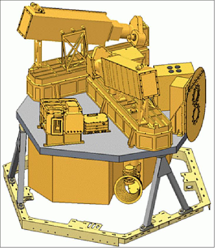
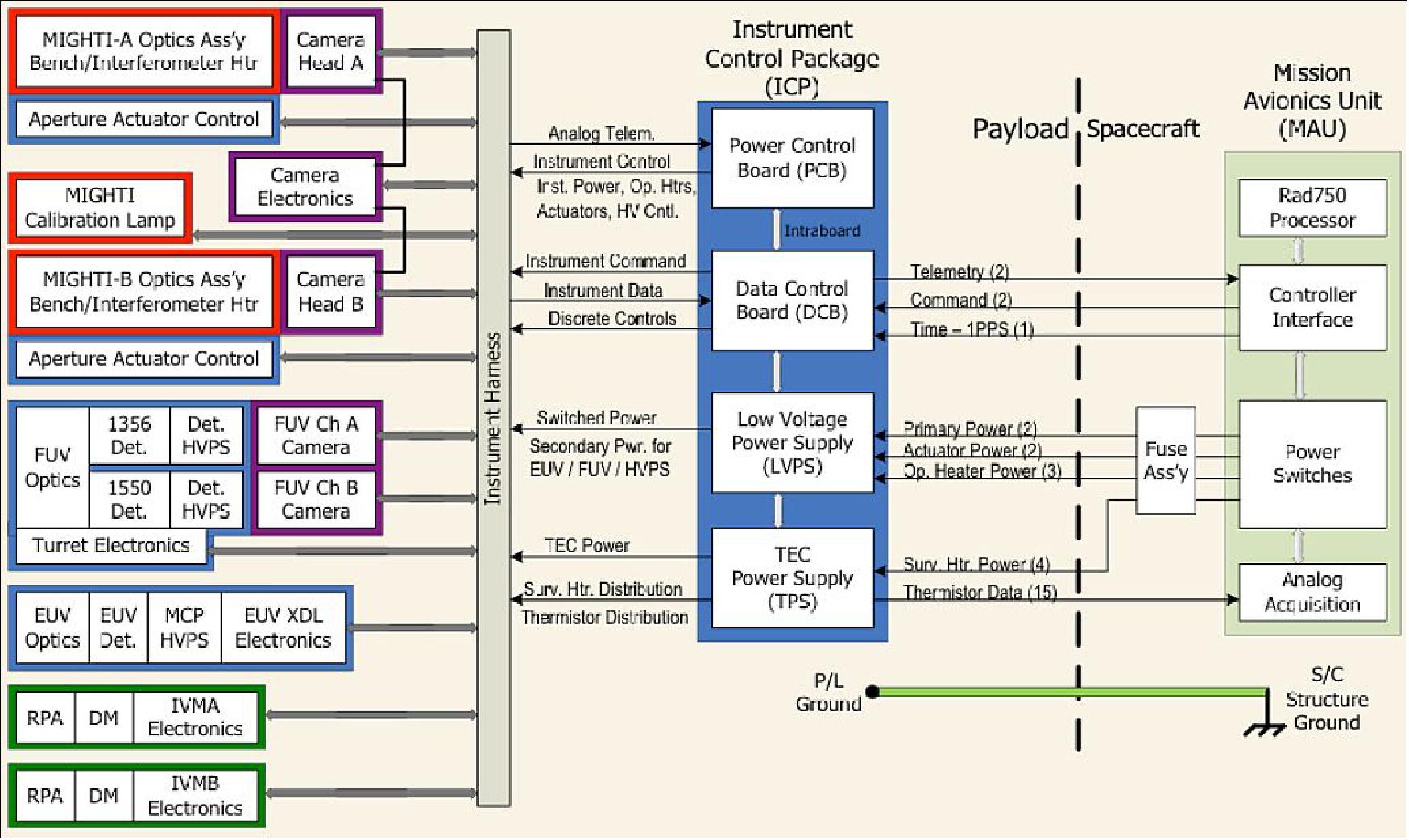
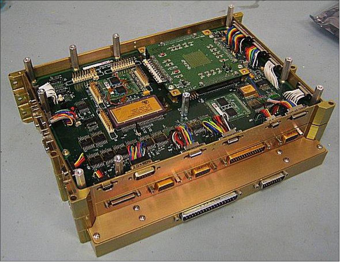
The ICP is the primary interface between the Spacecraft avionics systems and the instrument payload. The ICP manages the distribution of power to each of the ICON instruments, and it manages the flow of data from the instruments that is routed to the spacecraft solid state recorder. Commands are sent to the ICP to control the mode of the instruments. For example, the ICP controls the apertures in the MIGHTI optical systems, and it controls the FUV turret position. All of the payload heaters are controlled by the ICP. The FSW (Flight Software) for the payload resides on the DCB (Data Control Board) which is one board in the ICP. The FSW is programmed to manage all facets of instrument operation, whether it's related to control, or data processing. 35)
Each of the ICP's four electronics boards is assembled at the SSL (Space Sciences Laboratory), in accordance with NASA approved procedures and inspection criteria.The ICP integrates all the capabilities necessary to run all 4 instruments into one unit. ICP contains all the following boards:
• Digital Control Board DCB with (2 MB MRAM)
• Provides all capability to command instruments and accept all sensor data
• Power Control Board PCB
• Provides all power to instruments, instrument heaters, and motors
• TPS (TEC Power Supply) for MIGHTI
• Power supply specifically to drive the TEC cooler for MIGHTI
• LCPS (Low Voltage Power Supply)
• Provides secondary power to instrument cameras and survival heaters
MIGHTI (Michelson Interferometer for Global High-resolution Thermospheric Imaging)
The MIGHTI instrument is provided by NRL (Naval Research Laboratory) with Christoph Englert as PI. The primary objective for MIGHTI is to determine thermospheric winds and temperatures. Wind measurements will be made between 90-300 km altitude (day) and between 90-105 km and 200-300 km (night) with a horizontal resolution of <500 km. Thermospheric temperature measurements are required for the 90-105 km range. These mission requirements drive the design of the instrument. 36) 37) 38) 39)
The wind information is determined from the Doppler shift of atomic oxygen airglow emission lines and the temperature is determined from the spectral shape of the O2 A-band emission. These naturally occurring emissions are present day and night and MIGHTI observes the red-line (O(1D)@630.0 nm) at heights near the peak in the ionospheric density (200-300 km altitude) resulting mainly from electron recombination and impact reactions with O2+ and O, and the green-line (O(1S) @ 557.7 nm) at the base of the thermosphere (~100 km altitude) originating mainly from three-body collisions (O+O+M) and subsequent energy transfer. Furthermore, bright, temperature sensitive near-infrared band emissions (0-0 band of O2(b1Sg+) @762.0 nm) in the 100 km altitude region are used to retrieve the temperature. Recent imaging with a handheld Nikon camera show how bright these emissions are at night (Figure 36). MIGHTI employs a high performance baffle so that these emissions can be observed during daytime as well.

Legend to Figure 36: The 762 nm O2 band emission (false color in image) provides temperatures, while the Doppler shift of the 557 nm (green) and 630 nm (red) OI emission lines provides wind profiles.
MIGHTI Instrument
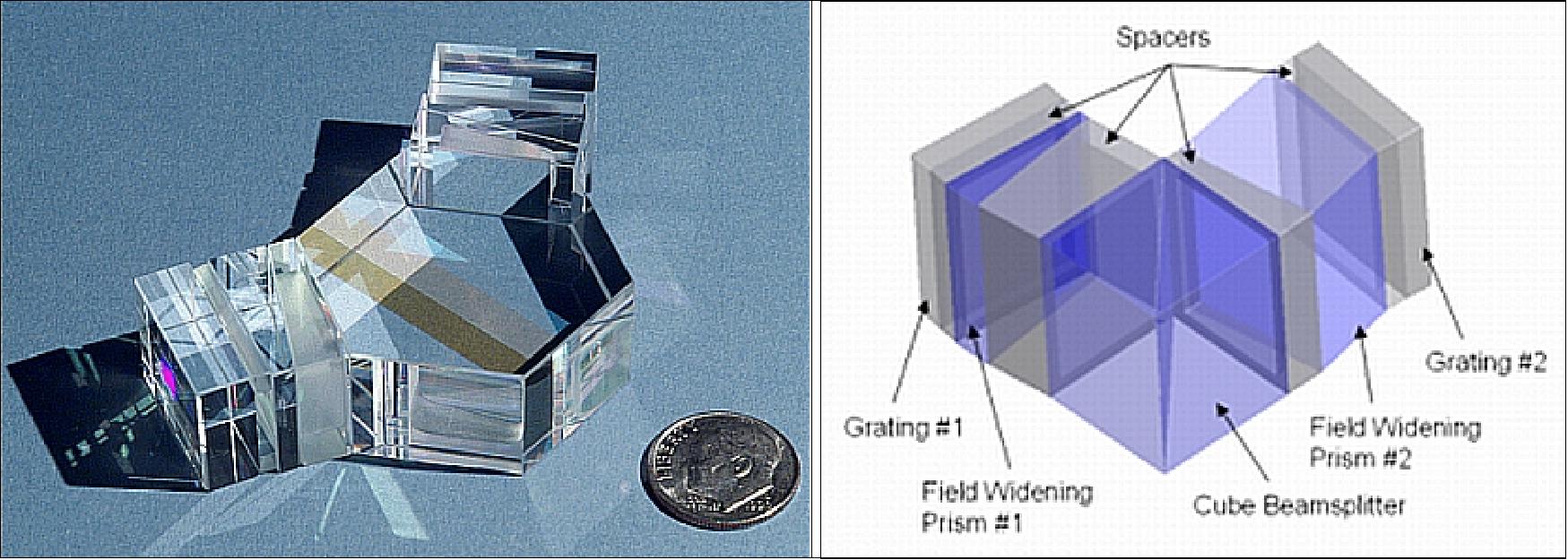
For the wind measurement, MIGHTI uses an interferometric technique that is based upon the proven approaches used for the WINDII (Wind Imaging Interferometer) flown on the NASA UARS satellite (launch on Sept. 12, 1991) and the SHIMMER (Spatial Heterodyne Imager for Mesospheric Radicals) instrument, flown on STPSat-1 (launch on Sept. 3, 2007). Figure 37 (left panel) shows the monolithic interferometer employed by SHIMMER. WINDII used the same airglow emission lines to measure Doppler wind in the same altitude range as required for ICON. The added capability based upon SHIMMER space flight heritage allows for a wind measurement virtually identical to WINDII and eliminates moving interferometer parts. The MIGHTI design utilizes a cubic beam splitter (Figure 37 : right panel) that allows for a smaller and lighter interferometer and and a more compact optical bench layout, while maintaining excellent optical performance.
The MIGHTI instrument consists of two sensor units with orthogonal fields of view, pointed 45° and 135° from the S/C velocity direction toward the port (northern) side of the spacecraft. With this viewing geometry, MIGHTI makes two perpendicular line-of-sight wind measurements of the same air volume less than 8 minutes apart. Each measurement represents a set of limb observations for tangent altitudes between 90 and 300 km. The vector combination from the two perpendicular lines of sight provides an altitude profile of wind vectors. Temperature measurements are performed coincident with the wind measurements using multi-color band shape measurements.
Conventional Michelson interferometers require mechanical stepping of a mirror to sample four or more path differences. The SHS ( Spatial Heterodyne Spectroscopy) approach for MIGHTI results in an improved, more rugged design, replacing the Michelson mirrors with fixed, tilted diffraction gratings. Fundamentally, each facet or groove of the tilted gratings can be regarded as a separate interferometer mirror, each representing a unique path difference, which permits the sampling of many path differences without moving interferometer parts. This eliminates the need for precision mirror stepping, which simplifies both the instrument development and on-orbit operation. The SHS technique was demonstrated by both SHIMMER and the REDDI (Redline DASH Demonstration Instrument), two of the heritage instruments. The basic design of one of the two MIGHTI optical units is shown in Figure 38.
Because the measured interferogram is comprised of straight fringes (rather than circular fringes produced by a Fabry-Perot Interferometer, for example), the MIGHTI field of view can cover the entire limb altitude range required for the ICON science without a scanning mechanism (Figure 38: right panel). This eliminates a scanning mechanism and minimizes complexity in development and during on-orbit operations.
The temperature of the lower thermosphere is derived from measurements of the band shape of the bright oxygen "Atmospheric Band" around 762 nm. Most recently, this technique was applied using data from the OSIRIS (Optical Spectrograph and Infrared Imaging System) instrument of CSA (Canadian Space Agency), flown on the Odin mission of Sweden (launch on Feb. 20, 2001 and operational in 2013). Similar measurements were also reported from the RAIDS (Remote Atmospheric and Ionospheric Detection System) instrument of NRL and The Aerospace Corporation, flown on the JEM/Kibo-EF (Exposed Facility) of the ISS (launch on Sept. 10, 2009).
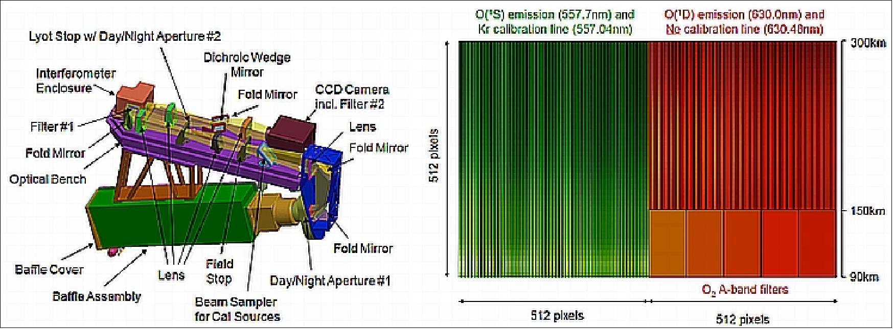
Legend to Figure 38, left panel: Light enters though the baffle, and is modulated by a temperature stabilized interferometer. A cooled CCD camera detects the fringe patterns to retrieve the wind profiles and the multispectral band signals to retrieve the temperature profiles. Right panel: Modeled airglow and calibration source signals on the MIGHTI detectors.
Two discrete MIGHTI units, their views separated by 90º, are mounted on the ICON Payload Interface Plate. Because the spacecraft motion introduces a different offset to the Doppler shift of the emissions across the horizontal imaging plane, a correction for this velocity differential is an important part of the wind retrieval.
FOV (Field of View), vertical x horizontal | 5.80º x 3.22º |
Total Etendue (A) for 90-300 km limb scene | 0.040 cm2 sr (night); 0.004 cm2 sr (day) |
Interferometer OPD (Optical Path Difference) interval | 4.2-6.0 cm |
Interferometer echelle grating groove density | 128 grooves/mm |
Interferogram visibility @ OPD 4.2 & 6 cm | 90% & 45% |
Interferometer efficiency | 35% |
Filter center wavelengths O('S) & O('D) | 557.7 (±0.2) nm & 630.0 (±0.2) nm |
Filter FWHM & transmission O('S) & O('D) | ≤2 nm & 60% |
Filter center wavelengths O2 A-band | 762.0, 762.0, 765.0 (±0.5) on band; 756.0, 772.2, (±0.5) nm off-band |
Filter FWHM & transmission O2 A-band | ≤2nm & 30% |
Dichroic wedge reflectivity | 95% |
Beamsampler transmission | 95% |
CCD dark current @ -45ºC | 0.1 electron/s |
CCD readout noise | 7 (ms) electrons/pixel/read |
CCD quantum efficiency | 95% |
Overall system transmission O('S) & O('D) | 16% |
Overall system transmission O2 A-band | 8% |
Detectors: e2v will provide two 2048 x 4096 pixel CCDs (Charge Coupled Devices) image sensors to equip the instrument. The sensors will be back-illuminated, coated with an anti-reflective coating to improve their sensitivity and operated in the frame transfer mode. 40)
FUV (Far Ultraviolet Imager)
The FUV imager is provided by UCB/SSL (PI: Stephen Mende). The primary objective for the FUV imager is to determine daytime thermospheric composition and nighttime ion density through imaging the limb and sub-limb of the ionosphere-thermosphere. 41)
During the day, photoelectrons colliding with atmospheric neutrals, N2 and O, produce emissions and by observing the limb brightness of the N2 LBH (Lyman-Birge-Hopfield) bands and of OI (Oxygen Iodine) at 135.6 nm, the density ratio of the neutral N2 and O atmospheric constituents can be retrieved.
At night the recombination of O+ ions with ionospheric electrons also creates OI 135.6 nm emissions and the nighttime electron density can be estimated from the limb brightness of 135.6 nm. ICON FUV will measure the altitude distribution of the OI 135.6 nm and N2 155 nm LBH dayglow emissions and the altitude and spatial distribution of the OI 135.6 nm nightglow emissions. These quantities can then be used to determine dayside O and N2 densities and altitude profiles, and the nightside O+ densities in the F-region.
FUV Instrument
The ICON FUV instrument is based upon the IMAGE FUV-SI ( Spectrographic Imager), flown on the NASA IMAGE mission (launch on March 25, 2000).
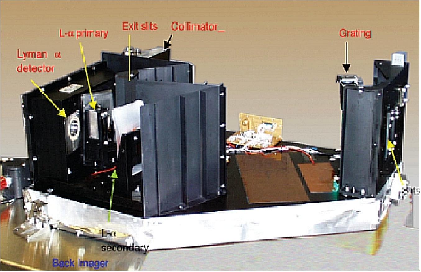
The FUV instrument is an off-axis Czerny-Turner spectrometer, tuned for observations at 135.6 and 155.0 nm. Upon entrance into the first slit, the scanning mirror sends the light toward a collimating first mirror, reflecting the light from the scene onto the FUV grating. The FUV light is separated at the grating and refocused onto the two exit slits by a secondary mirror. The two intensified CCD detectors capture the images of OI and N2 light. The image of the scene is preserved.
The project selected this grating type of spectrographic "filter" because it minimizes contamination by out-of-band light leaks that are typically a problem for non-grating type FUV cameras and the spectrograph also has the spectral resolution to reject unwanted contamination by the bright optically thick 130.4 nm O line. FUV is nominally pointed 20º down towards nadir from the -Y axis of ICON to image the northern limb and sub-limb. The ICON FUV instrument is illustrated in Figure 40.
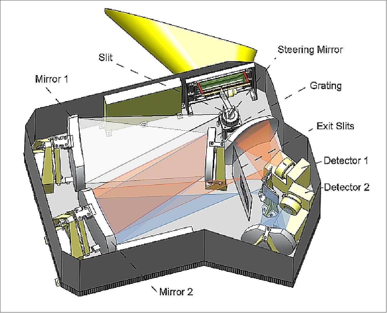
A small (40 mm x 12 mm) motorized steering mirror is placed in front of the entrance slit to allow viewing approximately in the plane of the magnetic field. The mirror has several fixed positions selectable by the instrument processor. As in the IMAGE heritage instrument, a sun sensor covering the full steering mirror range will command the safing of the high voltages to prevent instrument damage due to accidental direct sun exposure. Light reflected by the steering mirror passes through a 6 mm x 32 mm entrance slit and is collimated by the first concave mirror. Mirror 1, besides acting as the spectrograph collimator, also focuses the scene viewed by the instrument near the grating, producing an intermediate image. The 4300 groves/mm grating is slightly convex with a 1.7 m radius of curvature separates the O line (illustrated in red) from the N2 bands (illustrated in blue). Mirror 2, in combination with the back imager camera mirrors, located behind each of the two exit slits, reproduce the intermediate image on each detector. There is an exit slit and the back imager camera consists of a de-centered inverse Cassegrain configuration for each of the two bands.
Field of View, vertical | -8 to -32 (20º) |
FOV, horizontal | 24º, steered ±20º |
Resolution cell (pixel at limb (V/H) | 4 / 16 km, 0.094º / 0.375º |
Number of cells (V/H) | 256 x 64 |
Entrance aperture | 6 mm x 32 mm |
Entendue/pixel | 2.06 x 10⁻⁵ cm2 rad2 |
Integration time | 12 s |
Wavelength/passband | 135.6; 155 nm |
Passband | 4 nm FWHM (to eliminate unwanted 130.4 nm airglow emissions) |
Transmission x QE | 3% |
Projected counting rate | 0.5 counts/pixel/exp/R (the counts are converted into equivalent photoelectrons; the instrument provides A/D units) |
On orbit star calibration | Once per week |
The two detectors for the ICON FUV instrument are MCP (Microchannel Plate) intensified CCD detectors with an active area of 25 mm (circular) coupled to a 1k x 1k CCD similar to IMAGE WIC. The CCD is a Dalsa FTT1010M, which is the same CCD used for the ISUAL (Imager of Sprites and Upper Atmospheric Lightning) instrument flown on the FormoSat-2 mission (launch on May 20, 2004). It will be binned 4 x4 to achieve the desired size of 256 x 256. Adjacent 4 pixels will be co-added to support the final 64 x256 format, easily meeting the detector spatial requirement. Incident FUV photons strike the CsI photocathode of the sealed Photek image tube which is a modification of the Photek tube flown on the NASA TIMED mission (launched December 07, 2001) in the GUVI (Global Ultraviolet Imager) and in the DMSP SSUSI (Special Sensor Ultraviolet Spectrographic Imager) instrument (launched October 18, 2003). The photoelectrons are multiplied by the 6 mm pore MCP with an overall gain set to a value controlled by the voltage applied across it. The gain is chosen to optimize the dynamic range and sensitivity of the detector, while conferring relative immunity to saturation when viewing bright dayglow. The MCP output electrons are proximity focused onto an aluminized phosphor screen deposited on the output fiber optic window producing visible emissions imaged by the CCD bonded to the fiber optic.
Using the TIMED GUVI limb data to evaluate the viewing conditions one may predict a scene in the FUV FOV with a mean brightness of 5 kR. With this target brightness and detector, the dual MCP electron gain can be set to a moderate level of ~5000, leading to a longer design lifetime (vs. the lifetime of a 106 gain system for XDL detectors). This approach provides operational flexibility by setting the electron gain to optimize dynamic range during day/night operations while the system operates close to the photoelectron shot noise limit.
The FUV sensor package includes the CCD drivers, the amplifiers, and the A/D converters. Regulated power is derived from the ICP low voltage power supply (LVPS) and serial data is produced for the DICB (Digital Imaging Control Board) in the ICP. Each detector includes two high voltage power supplies, one for the MCP (0-2500 V) and one for the phosphor (0-5000 V). The HV power supplies are mechanically packaged with the intensifiers. In operation, HV commands use a two-step protocol, that requires a digital key to enable the operation. A sun sensor provides direct override of the HV, in the event of sun exposure. During ground testing, an HV enable plug, only installed when HV operation is appropriate, provides an additional level of operator error protection. This system has been used in many similar HV applications, e.g. on several spacecrafts e.g. IMAGE, FormoSat-2 (ISUAL) and THEMIS.
The steering mirror has a horizontal freedom of motion allowing a ±20° movement of the 24° FOV. This allows the FOV to be directed toward the local magnetic field for nighttime imaging observations along the magnetic field. The mirror can be used to block the sun when the instrument is commanded to safe hold. The mirror is driven by a stepper motor drive system that was flown in the ISUAL instrument on FormoSat-2.
EUV (Extreme Ultraviolet Imager)
The primary objective for the EUV profiler is to determine the altitude profile of the dayside ionospheric density through limb imaging in the extreme ultraviolet range. 42)
One of the most prominent terrestrial airglow features is the OII 83.4 nm triplet emission. The strongest "initial source" of photons is solar photoionization of neutral atomic oxygen around 160-175 km. The Sun also emits 83.4 nm photons, serving as a secondary source whose impact on the dayside airglow increases with altitude above the ionospheric peak. The 83.4 nm photons propagating upward from the initial source or downward from the Sun undergo resonant scattering by O+, the dominant positive ion within the F-region, and capture the shape of the F-region ion distribution. This is illustrated in Figure 42.
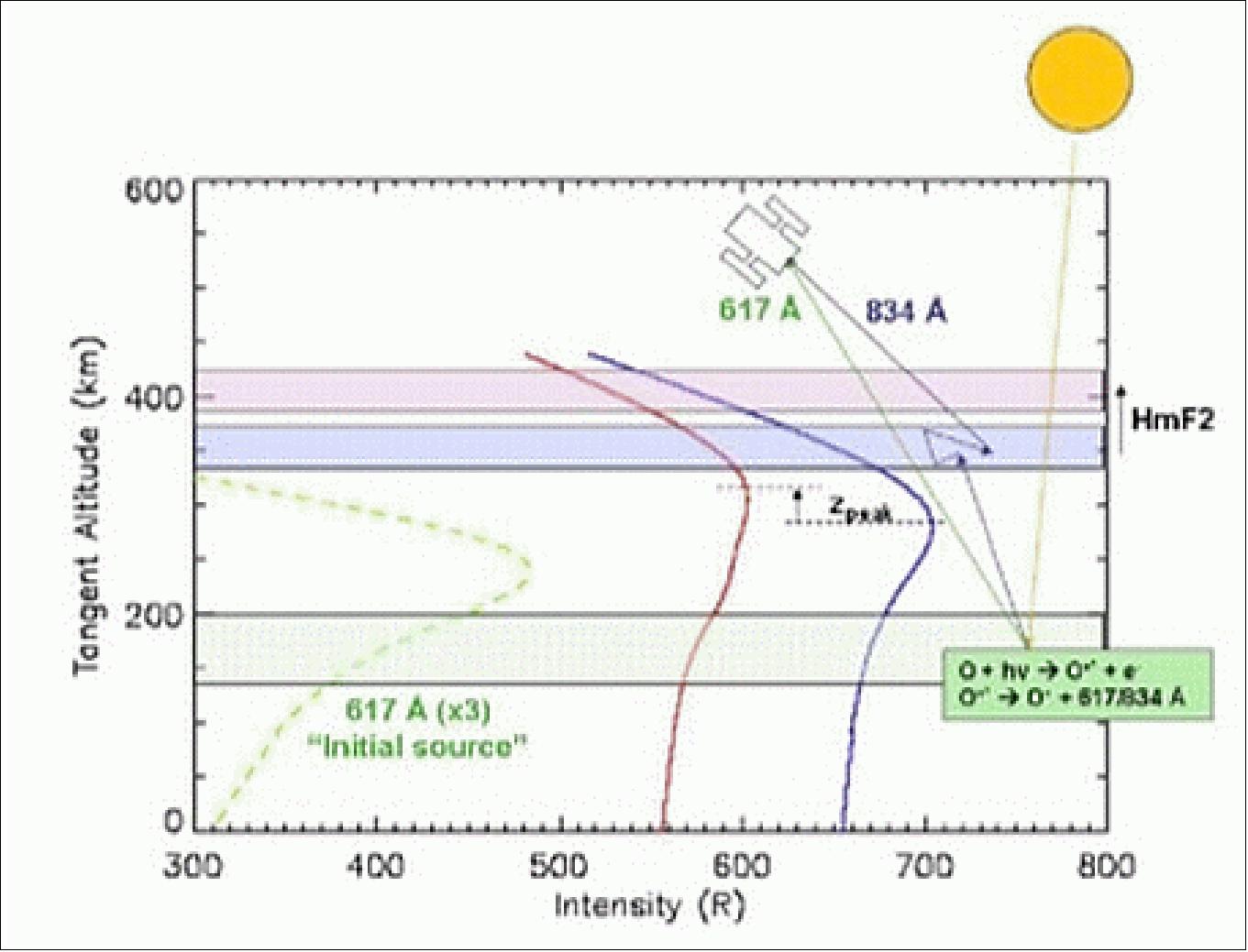
This EUV instrument follows the heritage of four UCB "EURD-class" astrophysical space flight instruments. These astrophysical instruments were designed for detecting the same wavelengths as the ICON-EUV instrument, but for signals that are an order of magnitude less bright than Earth's airglow. The interpretation of the EUV dayglow builds on the recent success of the SSULI (Special Sensor Ultraviolet Limb Imager) and RAIDS (Remote Atmospheric and Ionospheric Detection System) missions.
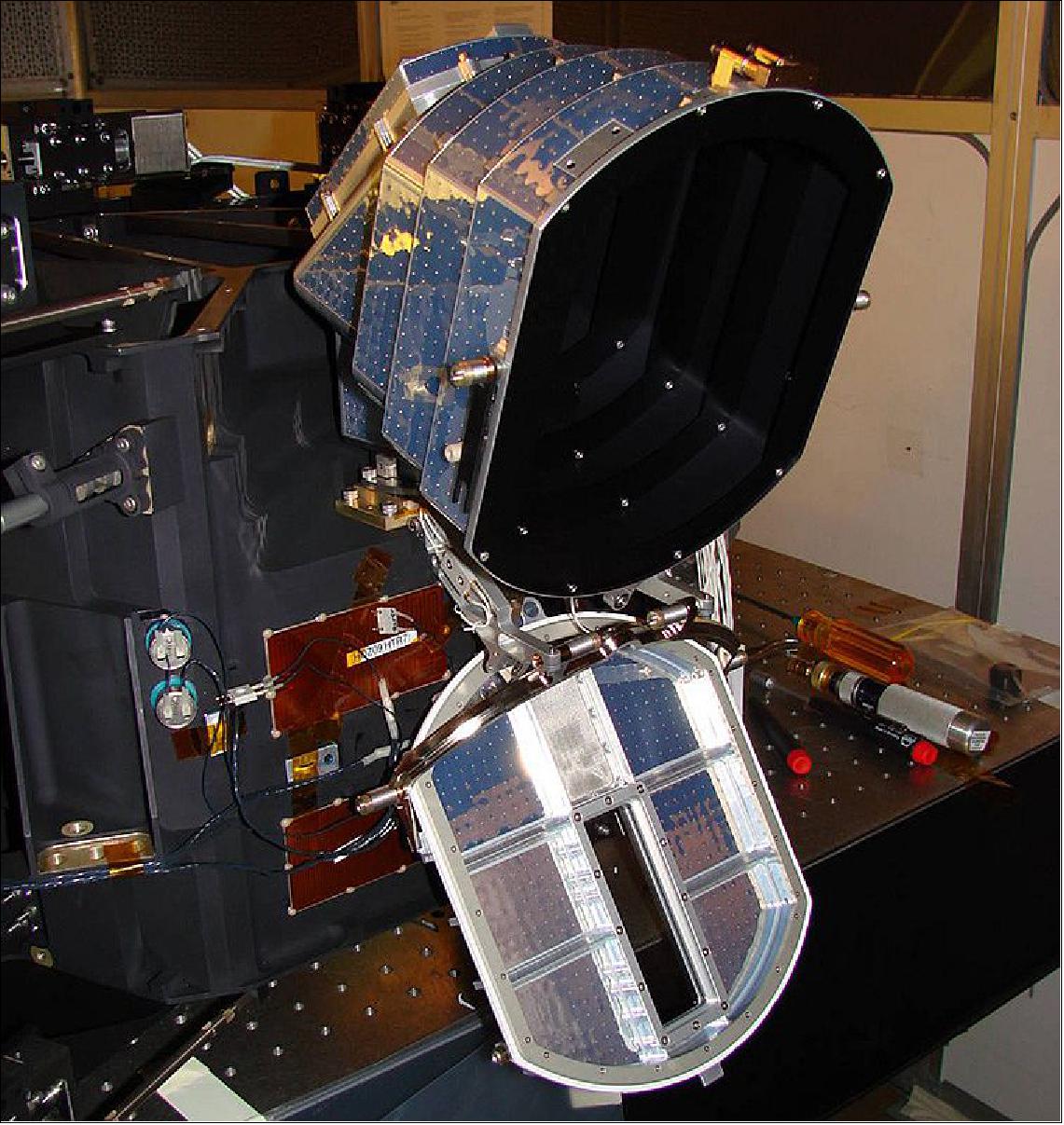
The ICON EUV spectral profiler is illustrated in Figure 43 . The EUV instrument measures these emissions with a straightforward grating spectrograph that provides spectral information in one dimension (horizontal) on the 2D detector, and altitude distribution of the emission brightness in the other dimension (vertical).
The EUV uses a simple "vertical pushbroom" one-dimensional imaging spectrograph of UCB design, consisting of a single diffraction grating that directly views a wedge of sky through a fixed slit aperture. The large difference in the vertical and horizontal curvature of the grating (toroidal design) permits the simultaneous vertical focusing of the scene located at great distances outside of the instrument and the horizontal focusing of the input slit located at the instrument entrance on the detector. The view wedge is dispersed and imaged into a spectrum per field angle on a photon-counting detector as shown in Figure 43. The simplicity of a single-optic design results in a highly efficient instrument and eases alignment and calibration issues compared to multi-optic designs.
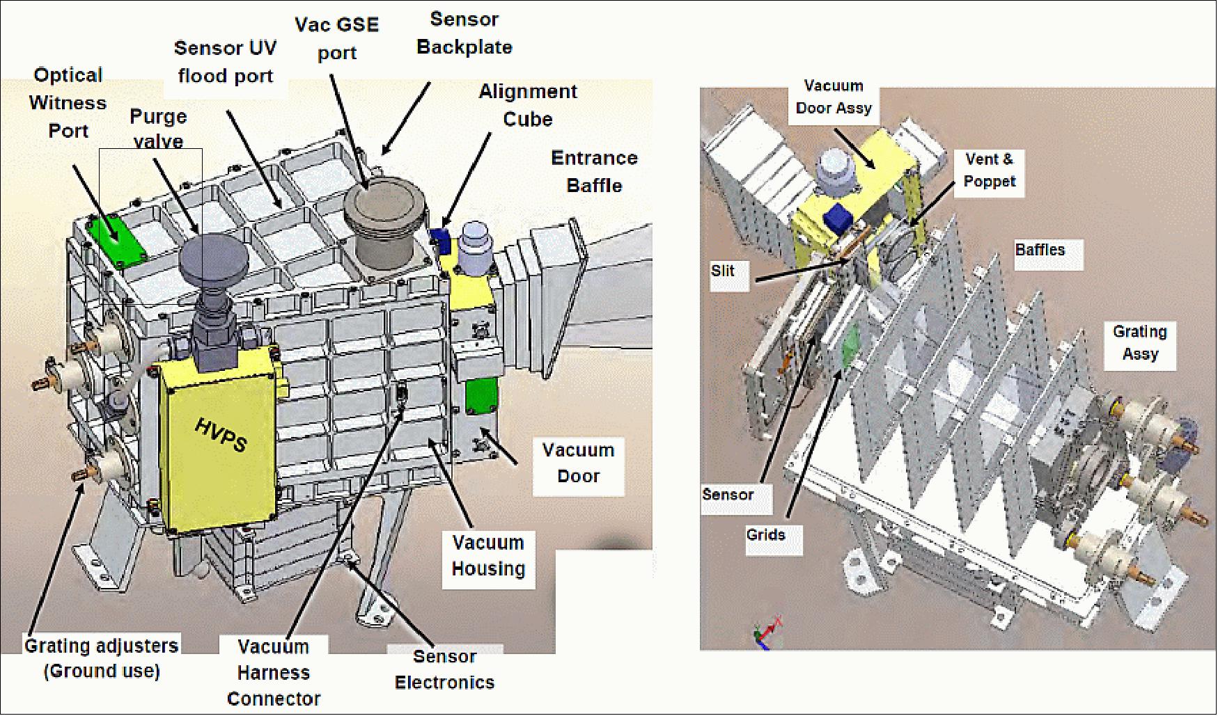
The ICON EUV features an enclosed aluminum structural cavity withstanding 1 atm. vacuum that acts as the optical bench and contains the diffraction grating and the open-faced MCP (Microchannel Plate) detector. The instrument cavity can be hermetically sealed with a one-time operable flap valve actuated in flight by a shape memory alloy mechanism. A FOV (Field of View) entrance baffle extends beyond the optical entrance to eliminate solar panel glints and minimize sun-pointing constraints. To reject entrance of low-energy ions into the optical cavity that could be accelerated into the MCP detector and cause excessive background noise, the hermetic optical cavity uses a low-voltage electric field applied to the slit and to fine metal grids placed over the entrance baffle, the space-venting aperture, and the detector face inside the cavity.
The horizontal field (12º) and the instrument scale set the ruled width of the grating to 40 mm. A 40 mm tall entrance slit, the imaging-direction pupil, and the imaging angle (16º) sets the 90 mm grating height. The EURD-type optical theory, given a 3000 l/mm ruling, estimates the toroidal figure of the grating (R=176 mm, ρ=336 mm), incident angle (13.7º), and the optimum slit-to-grating distance and detector-to-grating incident angles (177 and 171 mm, respectively). Numerical ray tracing shows that the spectral resolution requirements allow a slit width of 890 µm which yields the per pixel geometric factor to 6.3 x 10⁻⁴ cm2 sr while maintaining a clean separation between 58.4 nm and 61.7 nm.
The glass diffraction grating uses straight holographic rulings blazed for 61.7 nm. Similar to one of the previous EURD-class instruments, SPEAR, the grating surface will be coated with chromium for ruling acceptance testing, and then over coated with boron carbide (B4C). Like SPEAR, the grating is adhesively mounted to a titanium block that interfaces to the structure via a compliant three-point mount. The points use spherical bearings on threaded mount rods to allow for remote, mechanized, optical alignment in an UV vacuum test chamber during ground tests. A set of internal baffle plates are arranged to block zero order radiation and stray diffraction grating orders from bright airglow lines.
The detector will use an open microchannel plate z-stack with a crossed delay line (XDL) detector (< 150 µm electronic resolution). We have flown these detectors on numerous missions including several rockets. The instrument electronics include a high voltage power supply attached to the cavity housing. A detector electronics module containing front end amplifiers and dual (X,Y) time delay to digital converters (TDCs) and a digital interface card are located in the XDL electronics stack. An existing electronics module is used that has been developed through the PKB-ALICE, LRO-ALICE, SSULI (DMSP), and JUNO-UVS flight programs.
Optical design | 1D spatial-imaging spectrometer |
Wavelength range, resolution | 55-90 nm, 3 nm FWHM (Full Width Half Maximum) |
Vertical FOV, horizontal FOV | 16º, 12º |
No of detectors | 1 |
Detector type | 15 x 50 mm active area MCP with XDL (Cross Delay Line) anode |
Detector electronic resolution | 150 µm |
Exposure duration | 1 image every 12 seconds |
Imaging resolution | 0.48º FWHM |
Digital processing | Time delay conversion in XDL electronics |
In flight test | Electronic simulation |
IVM (Ion Velocity Meter)
The IVM instrument is provided by UT (University of Texas), Dallas (PI: Rod Heelis). The IVM consists of two planar thermal ion sensors, a RPA (Retarding Potential Analyzer) and an IDM (Ion Drift Meter) that will provide measurements of the ion drift velocity in the spacecraft reference frame, the ion temperature and the total ion number density at the location of the spacecraft. Using a magnetic field model the drift velocity vector can be converted to a local electric field perpendicular to the magnetic field and expressed in a geographic and/or geomagnetic coordinate system. Above 250 km altitude the direction parallel to the Earth's magnetic field is an electric equipotential for horizontal scales greater than 25 km. Thus the electric field at the spacecraft location can be translated to any other location along the magnetic field through the spacecraft. 43)
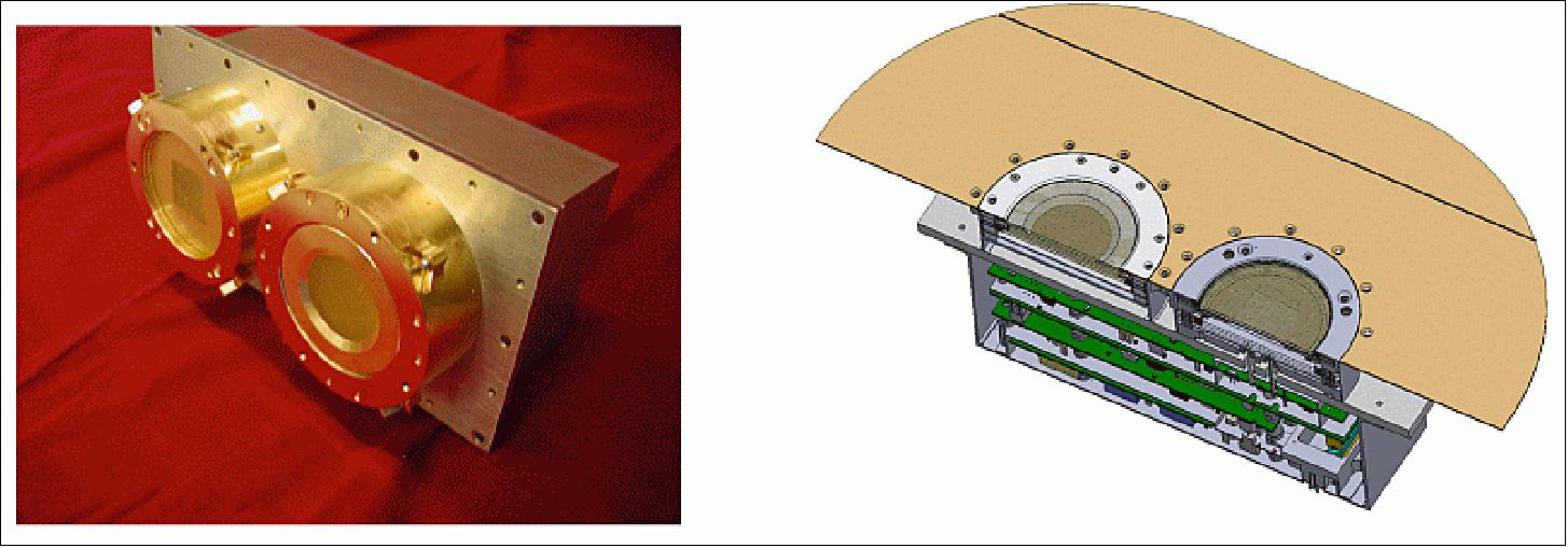
The IVM instrument is derived with little change from the instrument that is presently operating successfully as part of the CINDI (Coupled Ion-Neutral Dynamics Investigation) project on the C/NOFS (Communication/Navigation Outage Forecast System) satellite (launch on April 16, 2008). The IVM sensors and sensor electronics are constructed as a single package and are mounted to view approximately along the spacecraft velocity vector through a common aperture plane that is isolated from the spacecraft ground. Figure 44 shows the sensor configuration that is flying on the CINDI mission and and a schematic illustration of the ICON configuration.
The aperture plane serves as the reference ground for the sensors and ensures that all external fields are uniform and normal to the entrance aperture. A portion of the aperture plane, the SenPot reference surface, is isolated from the reference ground. The SenPot amplifier generates a potential with respect to spacecraft ground to maintain the IVM reference ground at the floating potential with respect to the plasma. The operation and data analysis techniques have extensive heritage from many previous missions starting with Atmosphere Explorer in the 1970's and subsequently the DMSP (Defense Meteorological Satellite Program) and ROCSAT-1/FormoSat-1 before the CINDI mission in 2008.
The RPA (Retarding Potential Analyzer) is a planar sensor that presents a circular aperture to the incoming plasma stream that is intersected by a number of planar semi-transparent conducting grids and a large solid collector. Two schematic views of the RPA sensor are shown in Figure 45.
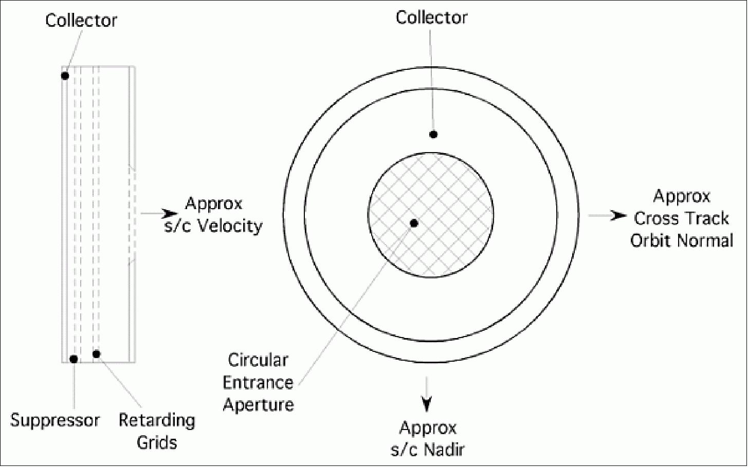
The sensor is mounted to view approximately along the satellite velocity through a large aperture plane that provides a uniform planar electrical ground reference potential. Grounded grids cover the entrance aperture to ensure that no internally applied potentials influence the ion beam trajectories prior to entering the sensor. Inside the sensor the ion beam traverses a series of semi-transparent grids before impacting the collector. The retarding grids are biased at potentials between 0 and 25 V and thus control the minimum energy that the ions must posses to reach the collector. A suppressor grid prior to the collector is biased at -12 V to reject ambient electrons and suppress photoelectrons ejected from the collector.
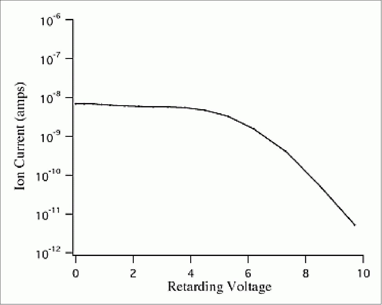
A current-voltage characteristic is obtained by measuring the ion current while the retarding voltage moves over a series of predetermined discrete levels. Retarding voltage sequences are chosen to optimize the sensor performance for the changing conditions expected in the ionosphere over a substantial part of a solar cycle. Figure 46 shows a simulated data curve obtained assuming a total ion concentration or 105 cm-3 with 20% H+ and 80% O+. This current-voltage characteristic has a well-known functional form that can be fitted to retrieve the ion drift component along the sensor look direction, termed , the ion temperature and the major constituent ions. The current at zero retarding voltage is used to derive the total ion number density.
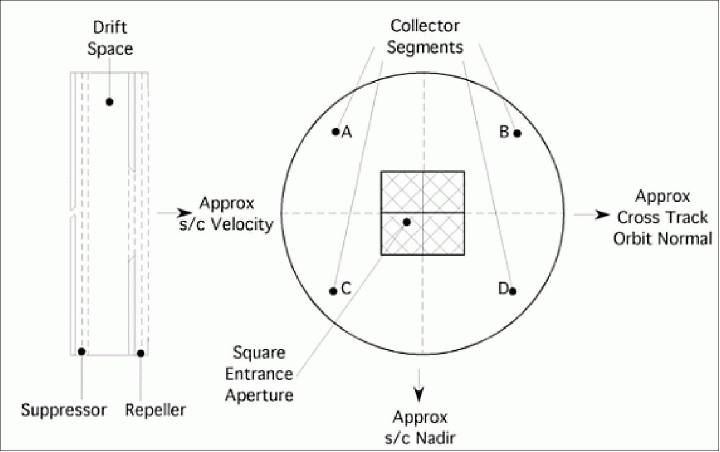
The IDM (Ion Drift Meter) is a planar sensor that presents a square aperture to the incoming plasma stream that is intersected by a number of planar semi-transparent conducting grids and a solid segmented collector. The collector segments are arranged such that the cuts lie approximately along the satellite nadir and the orbit normal, which define the local vertical and horizontal directions perpendicular to the satellite motion. Two schematic views of the IDM sensor are shown in Figure 47.
The sensor is mounted to view approximately along the satellite velocity through a larger aperture plane that provides a uniform planar electrical ground reference potential. Two planar grids are placed prior to the entrance aperture to prevent the passage of light ion species. To ensure that no internally applied potentials influence the ambient external plasma the outermost grid, which is coplanar with the aperture plane, is always tied to reference ground, as is the aperture plane. This suppressor grid is biased at -12 V to prevent access of ambient thermal electrons to the collector and to suppress electrons liberated from the collector by solar euv radiation. Figure 48 shows a schematic cross-section and the O+ beam trajectory, in the plane of the satellite motion and the local vertical. Also shown is the electrical configuration indicating the current measured by logarithmic electrometers that provide the inputs to a linear difference amplifier.
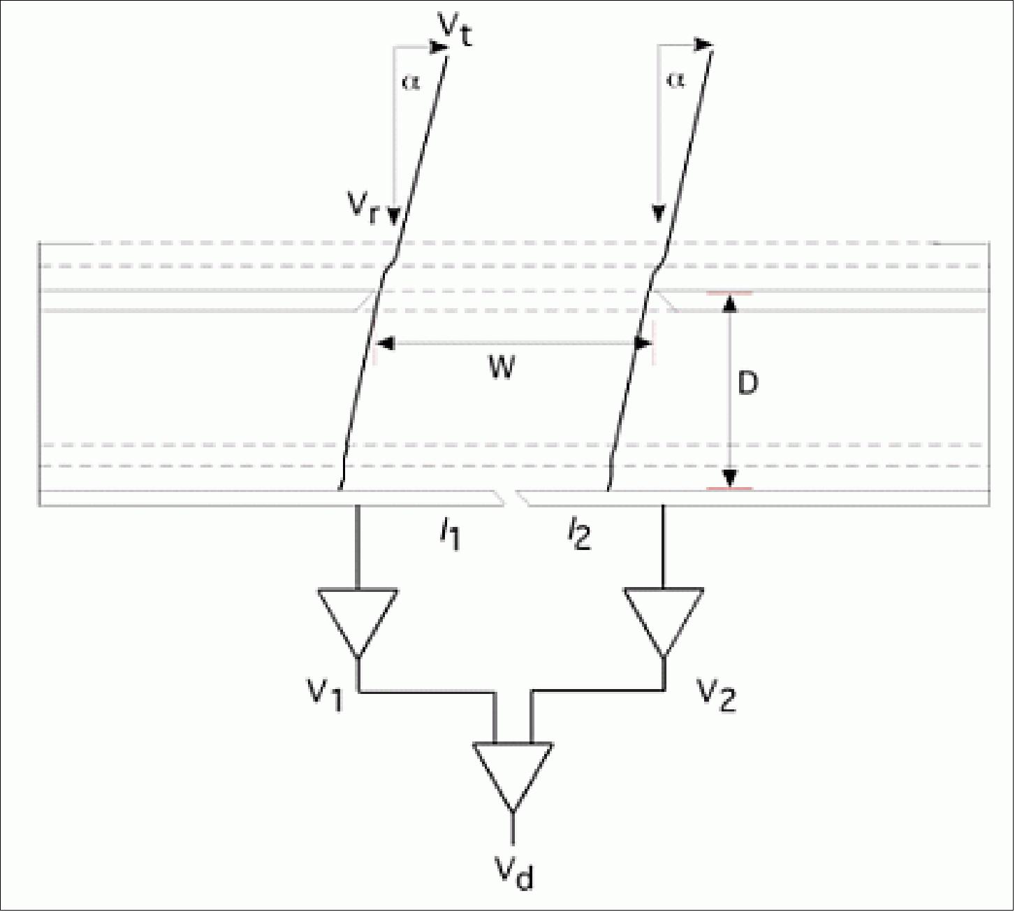
The RPA utilizes an automatic ranging linear electrometer to measure the ion current for discrete values of the retarding potential that may specified by ground command and stepped at a 32 Hz rate. A nominal sweep sequence will comprise 16 points, recorded with 14-bit accuracy and executed in 0.5 seconds. The IDM utilizes two logarithmic electrometers that may be engaged to measure currents from collector segments that are alternately horizontal and vertical in the transverse direction. These signals provide the inputs to a linear difference amplifier that directly provides a signal proportional to the tangent of the ion arrival angle. The difference amplifier is sampled at 32 Hz with 14-bit accuracy, providing alternating horizontal and vertical arrival angles that provide a measure of the dynamic stability of the ionosphere and may be averaged to provide the transverse ion drift components that accompany the ram drift component derived by the RPA. The instrument performance capabilities are shown in Table 5.
No | Requirement | Specification | Capability |
IV1 | Ion drift dynamic range | -1000 to 1000 m/s | -2000 to 2000 m/s |
IV2 | Vertical ion drift accuracy | 5 m/s | 3 m/s (assumes vehicle attitude specification of 0.02º) |
IV3 | Total ion concentration dynamic range | 5 x 10³ -5 x 106 cm-3 | 103 - 7 x 106 cm-3 |
IV4 | Horizontal sample distance | 250 km | 4 km |
Ground Segment
The MOC (Mission Control Center) at UCB/SSL is tasked with operating the ICON mission. The MOC is currently operating THEMIS, ARTEMIS, RHESSI and NuSTAR, all NASA Explorer missions, recently operating the FAST Explorer as well.
For ICON, operations begin early with the integration of the spacecraft at Orbital ATK, where Berkeley operations engineers will work with the spacecraft engineers in all the initial tests and checkout of the bus. This continues with the arrival of the scientific payload, through integration of the full ICON observatory with the launch vehicle. This is exactly how Berkeley has worked with Orbital on NuSTAR, a NASA Small Explorer (PI F. Harrison – Caltech) which UCB is currently operating (quite successfully!).
With launch, ICON will be placed into a 27º inclination orbit and communications will immediately be established between ICON and the UCB MOC using TDRSS, the orbiting NASA communications network. Ground contacts are planned and used from then on to command and operate ICON. Ground contacts with ICON are performed mainly from the Berkeley Ground Station, with backup contacts out of Wallops and Santiago. 44)

References
1) Dwayne Brown, "NASA Selects Explorer Projects To Probe Earth's Upper Atmosphere ," NASA Contract Release: C13-100, April 12, 2013, URL: http://www.nasa.gov/home/hqnews/2013/apr/HQ_C13-100_Helio_Explorers.html
2) Scott England, "ICON selected to be NASA's next Explorer Mission," UCB/SSL, April 12, 2013, URL: https://icon.ssl.berkeley.edu/News/Blog/archive/4-2013
3) "ICON – The Ionospheric Connection Explorer," UCB/SSL, URL: http://icon.ssl.berkeley.edu/science/
4) "The Ionospheric Connection Explorer ICON: A pioneering research mission for space physics and aeronomy," AGU Fall Meeting, Dec. 3-7, 2012, San Francisco, CA, USA, URL: http://icon.ssl.berkeley.edu/wp-content/uploads/2013/04/ICON_FALL_AGU_2012.pdf
5) Robert Sanders, "UC Berkeley selected to build NASA's next space weather satellite," UC Berkeley selected to build NASA's next space weather satellite," Space Daily, April 17, 2013, URL: http://www.spacedaily.com/reports/UC_Berkeley_selected_to_build_NASAs_next_space_weather_satellite_999.html
6) "ICON Fact Sheet," URL: http://sprg.ssl.berkeley.edu/ICON/
7) "ICON- Exploring Where Earth's Weather Meets Space Weather," UCB/SSL, URL: http://dev.icon.ssl.berkeley.edu/
8) "ICON Science Overview," ICON Science Overview," UCB/SSL, URL: http://dev.icon.ssl.berkeley.edu/Science/Science-Overview
9) "ICON - Studying the Earth-Sun Connection in the Ionosphere," Orbital ATK, Factsheet, URL: https://web.archive.org/web/20160313214613/https://www.orbitalatk.com/space-systems/science-national-security-satellites/science-environment-satellites/docs/FS010_13_OA_3862%20ICON.pdf
10) http://icon.ssl.berkeley.edu/spacecraft/
11) "Orbital Selected By NASA For $50 Million Contract To Build Icon Space Weather Satellite," Orbital Press Release, April 29, 2013, URL: https://web.archive.org/web/20130511051910/https://www.orbital.com/NewsInfo/release.asp?prid=856
12) Bob Granath, "Payload Fairing Installed for ICON Mission," NASA, 17 October 2018, URL: https://blogs.nasa.gov/icon/2018/10/17/payload-fairing-installed-for-icon-mission/
13) "Northrop Grumman Completes Orbital ATK Acquisition, Blake Larson Elected to Lead New Innovation Systems Sector," Northrop Grumman News, 6 June 2018, URL: https://news.northropgrumman.com/news/releases/northrop-grumman-completes-orbital-atk-acquisition-blake-larson-elected-to-lead-new-innovation-systems-sector
14) "ICON mission overview," NASA 3 Nov. 2017, URL: https://web.archive.org/web/20221108233825/https://www.nasa.gov/content/icon-mission-overview/
15) Robert Sanders, "Space weather satellite ICON on course for summer 2017 launch," Berkeley News, April 7, 2016, URL: http://news.berkeley.edu/2016/04/07/space-weather-satellite-icon-on-course-for-summer-2017-launch-2/
16) Claire Raftery, "ICON integration and testing is underway at the Space Dynamics Lab in Utah," UCB/SSL, March 16, 2016, URL: http://dev.icon.ssl.berkeley.edu/Latest-News/Blog
17) Karen Fox, "ICON Cleared for Next Development Phase," NASA, Nov. 12, 2014, URL: http://www.nasa.gov/content/goddard/icon-cleared-for-next-development-phase/
18) Thomas Immel, "ICON Passes Preliminary Design Review," July 24, 2014, URL: http://icon.ssl.berkeley.edu/
19) Thomas Immel, "ICON Passes System Requirements Review," Jan. 14, 2014, URL: http://icon.ssl.berkeley.edu/icon-passes-system-requirements-review/
20) Robert Sanders, "UC Berkeley selected to build NASA's next space weather satellite," April 16, 2013, URL: http://newscenter.berkeley.edu/2013/04/16/uc-berkeley-selected-to-build-nasas-next-space-weather-satellite/
21) "NASA Spacecraft Launches on Mission to Explore Frontier of Space," NASA Press Release 19.082, 11 October 2019, URL: https://www.nasa.gov/press-release/nasa-spacecraft-launches-on-mission-to-explore-frontier-of-space
22) Stephen Clark, "Launch Schedule — ICON," Early 2018, URL: https://spaceflightnow.com/launch-schedule/
23) "Two Heads Are Better than One: ICON & GOLD Teaming Up To Explore Earth's Interface to Space," NASA, 4 Jan. 2018, URL: https://www.nasa.gov/feature/goddard/2018/two-heads-are-better-than-one-icon-gold-teaming-up-to-explore-earths-interface-to-space
24) Joshua Buck, George H. Diller, "NASA Awards Launch Services Contract for Ionospheric Connection Explorer ," NASA, Contract Release C14-047 , Nov. 20, 2014, URL: http://www.nasa.gov/press/2014/november/nasa-awards-launch-services-contract-for-ionospheric-connection-explorer/#.VG7AXcmSz_U
25) Mara Johnson-Groh, "NASA Mission Finds Tonga Volcanic Eruption Effects Reached Space," NASA Feature, 10 May 2022, URL: https://www.nasa.gov/feature/goddard/2022/sun/nasa-mission-finds-tonga-volcanic-eruption-effects-reached-space
26) Brian J. Harding, Yen-Jung Joanne Wu, Patrick Alken, Yosuke Yamazaki, Colin C. Triplett, Thomas J. Immel, L. Claire Gasque, Stephen B. Mende, Chao Xiong, "Impacts of the January 2022 Tonga Volcanic Eruption on the Ionospheric Dynamo: ICON-MIGHTI and Swarm Observations of Extreme Neutral Winds and Currents," Geophysical Research Letters, Volume49, Issue9, 16 May 2022, e2022GL098577, https://doi.org/10.1029/2022GL098577
27) Lina Tran, "Strong Winds Power Electric Fields in the Upper Atmosphere, NASA's ICON Finds," NASA Feature, 29 November 2021, URL: https://www.nasa.gov/feature/goddard/2021/strong-winds-power-electric-fields-in-upper-atmosphere-icon
28) Thomas J. Immel, Brian J. Harding, Roderick A. Heelis, Astrid Maute, Jeffrey M. Forbes, Scott L. England, Stephen B. Mende, Christoph R. Englert, Russell A. Stoneback, Kenneth Marr, John M. Harlander & Jonathan J. Makela, "Regulation of ionospheric plasma velocities by thermospheric winds," Nature Geoscience, Published: 29 November 2021, https://doi.org/10.1038/s41561-021-00848-4
29) Mara Johnson-Groh and Jessica Merzdorf, "NASA Researchers Track Slowly Splitting 'Dent' in Earth's Magnetic Field," NASA Feature, 17 August 2020, URL: https://www.nasa.gov/feature/nasa-researchers-track-slowly-splitting-dent-in-earth-s-magnetic-field
30) Lina Tran "First ICON Science Data Released to Public," NASA ICON Mission, 22 June 2020, URL: https://blogs.nasa.gov/icon/2020/06/22/first-icon-science-data-released-to-public/
31) Karin Hauck, "Newly-Launched ICON Observatory Sees the December 2019 Eclipse," UCB/SSL, 20 February 2020, URL: https://icon.ssl.berkeley.edu/news/newly-launched-icon-observatory-sees-the-december-2019-eclipse
32) "ICONic Views of the Atmosphere," NASA Earth Observatory, Image of the Day for 7 January 2020, URL: https://earthobservatory.nasa.gov/images/146079/iconic-views-of-the-atmosphere
33) "Postcards from the Edge of Space: Scientists Present New Ionosphere Images and Science," NASA Feature, 10 December 2019, URL: https://www.nasa.gov/feature/goddard/2019/postcards-from-the-edge-of-space-scientists-present-new-ionosphere-images-and-science
34) "ICON post-launch status," UCB/SSL, 24 October 2019, URL: https://icon.ssl.berkeley.edu/news/icon-post-launch-status
35) "The Instrument Control Package - ICP," UCB/SSL, URL: http://dev.icon.ssl.berkeley.edu/Observatory/Instrument-Control-Package
36) Kenneth D. Marr, Aidan S. Thayer, Christoph R. Englert, and John M. Harlander "Determining the thermomechanical image shift for the MIGHTI instrument on the NASA-ICON satellite," Optical Engineering, Vol. 59(1), 013102, published: 11 January 2020, https://doi.org/10.1117/1.OE.59.1.013102
37) http://icon.ssl.berkeley.edu/instruments/mighti/
38) "NRL's MIGHTI Slated for Launch on ICON Mission," NRL, May 13, 2013, URL: http://www.nrl.navy.mil/media/news-releases/2013/nrls-mighti-slated-for-launch-on-icon-mission
39) C. R. Englert, J. M. Harlander, C. M. Brown, A. W. Stephan, J. J. Makela, K. D. Marr, T. J. Immel, "The Michelson Interferometer for Global High-resolution Thermospheric Imaging (MIGHTI): Wind and Temperature Observations from the Ionospheric Connection Explorer (ICON)," OSA Optics and Photonics Congress, Imaging and Applied Optics, Technical Digest, FW1D.3, ISBN 978-1-55752-975-6, 2013
40) "e2v image sensors chosen for NASA's MIGHTI mission," ev2, Feb. 5, 2014, URL: http://www.e2v.com/news/e2v-image-sensors-chosen-for-nasas-mighti-mission/
41) http://icon.ssl.berkeley.edu/instruments/fuv/
42) "Extreme Ultra Violet Imaging Spectrograph (EUV)," URL: http://icon.ssl.berkeley.edu/instruments/euv/
43) "Ion Velocity Meter (IVM)," URL: http://icon.ssl.berkeley.edu/instruments/ivm/
44) "Mission Operations," UCB/SSL, URL: http://dev.icon.ssl.berkeley.edu/Operations/Mission-Operations
Spacecraft Launch Mission Status Sensor Complement Ground Segment References Back to top