INSAT-3A (Indian National Satellite-3)
EO
Atmosphere
Ocean
Cloud type, amount and cloud top temperature
Quick facts
Overview
| Mission type | EO |
| Agency | ISRO |
| Mission status | Mission complete |
| Launch date | 09 Apr 2003 |
| End of life date | 08 Nov 2016 |
| Measurement domain | Atmosphere, Ocean, Land |
| Measurement category | Cloud type, amount and cloud top temperature, Liquid water and precipitation rate, Radiation budget, Multi-purpose imagery (land), Surface temperature (land), Albedo and reflectance, Surface temperature (ocean), Atmospheric Winds |
| Measurement detailed | Precipitation intensity at the surface (liquid or solid), Cloud type, Land surface imagery, Upward long-wave irradiance at TOA, Earth surface albedo, Land surface temperature, Sea surface temperature, Wind profile (horizontal) |
| Instruments | DRT-S&R, VHRR, CCD camera |
| Instrument type | Imaging multi-spectral radiometers (vis/IR), Communications |
| CEOS EO Handbook | See INSAT-3A (Indian National Satellite-3) summary |
INSAT-3A (Indian National Satellite-3) Series
INSAT-3A Mission Status Payloads References
The INSAT-3 series of ISRO (Indian Space Research Organization) is a multipurpose spacecraft with an all Ku-band transponder layout for direct-to-home television and roof-top data communication. The satellites incorporate state-of-the-art communication technology such as high power antennas, steerable beam and digital compression/decompression capabilities. The solar panel of the INSAT-3A spacecraft uses an advanced rigid deployable sun-oriented array of GaAs/Ge cells with an area of 26.5 m2.
Mission | Launch, S/C parameters | Meteorological Payload | Power, Battery, Other |
INSAT-3B | Launch March 21, 2000 on Ariane-5 from Kourou, dry mass of 970 kg, launch mass of 2070 kg, co-located with INSAT-2E at 83º E, | None | 1.7 kW , NiH2, 70 Ah, 27 cells, |
INSAT-3C | Launch Feb. 3, 2002 on Ariane-4 from Kourou, the S/C is positioned 74º E; launch mass of = 2,750 kg | None | 24 transponders in C-band |
Kalpana-1 / MetSat-1 | Launch Sept. 12, 2002 on PSLV from SHAR, India; launch mass =1,055 kg | VHRR/2, DRT | The mission is described on the eoPortal under the Kalpana-1 title. |
INSAT-3A | Launch April 9, 2003 on Ariane-5 from Kourou, launch mass=2,950 kg, dry mass of 1348 kg, location at 93.5º E, design life = 12 years | VHRR/2, CCD Camera, DCS, SASAR | 3.1 kW |
INSAT-3E | Launch Sept. 28, 2003 on Ariane-5 from Kourou, launch mass= 2775 kg | None | 24 transponders in C-band |
INSAT-3D | Launch on July 25, 2013 on Ariane-5 from Kourou | Imager (6 bands), Sounder (19 channels), DCS (DRT), SASAR | Note: The INSAT-3D spacecraft is described in a separate file. |
The description of the INSAT-3 spacecraft series focuses on the missions with meteorological payloads.
Overview
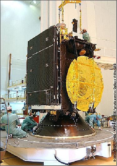
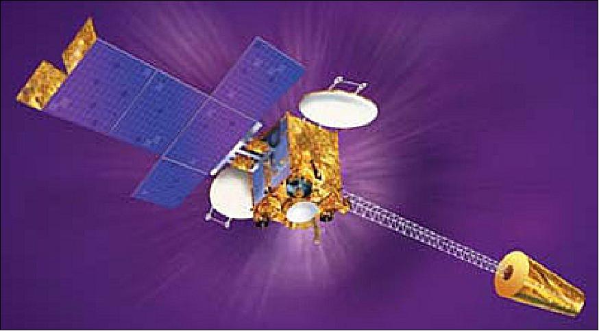
INSAT-3A is a multipurpose satellite like its predecessors supporting the functions of communications, television broadcasting, meteorology and a SAS&R (Satellite Aided Search and Rescue) system. The spacecraft structure is a cuboid of 2.0 m x 1.77 m x 2.8 m with a solar array on the south and solar sail & boom on the north (deployed length of 24.4 m).
The communications payload features 24 transponders, 12 operating in the normal C-band frequency, six in Extended C-band and six in Ku-band. Nine of the twelve normal C-band transponders provide expanded coverage and the remaining three have India coverage beam. All the extended C-band as well as the Ku-band transponders have India coverage beams. INSAT-3A also carries a Ku-band beacon.
The spacecraft is based on the the I-3k bus, it is 3-axis stabilized using sensors, momentum and reaction wheels, solar flaps, magnetic torquers and eight 10 N and eight 22 N RCS (Reaction Control Thrusters). S/C propulsion is provided by 440 N Liquid Apogee Motor with MON-3 and Control (Mixed Oxides of Nitrogen) and MMH (Mono Methyl Hydrazine) for orbit raising. The EPS (Electric Power Subsystem) uses a solar array of 26.6 m2 providing a power of 3.1 kW. Two 70 Ah NiH2 batteries support full payload operation during eclipse periods.
The S/C design life is 12 years. The S/C launch mass is 2950 kg, the S/C dry mass is 1,348 kg.
Launch
INSAT-3A was launched on Ariane 5G from Kourou on April 9, 2003. Another payload on this dual-launch was the Galaxy-12 communications satellite. 1)
Orbit of INSAT-3A: Geostationary orbit, nominal altitude ~35,786 km, location at 93.5º east longitude.
Mission Status
• January 2017: ISRO operates currently the following meteorological missions in GEO: Kalpana-1 (launch Sept. 12, 2002), INSAT-3A (launch April 9, 2003), INSAT-3D (launch July 25, 2013) and INSAT-3DR (launch Sept. 8, 2016).
• The INSAT-3A spacecraft and its meteorological payload are operating nominally in 2015 (in its 12th year on orbit). 2)
- In CGMS-42-IMD-WP-01, IMD (India Meteorological Department) informed CGMS (Coordination Group for Meteorological Satellites) that currently three Indian meteorological satellites are in operation: Kalpana-1, INSAT-3A and INSAT-3D. With the help of these three satellites, IMD is able to monitor several phenomena like, cyclones, western disturbances, thunderstorms, etc., and provide early warnings to the affected areas. 3)
• The INSAT-3A spacecraft and its meteorological payload are operating nominally in 2013. 4)
• In April 2012, the INSAT-3A spacecraft is 9 years on orbit. The VHRR/2 instrument and the CCD Camera are each operated about 4 times/day. 5)
• The INSAT-3A spacecraft and its payload are operating nominally in 2011.
• The INSAT-3A spacecraft and its payload are operating nominally in 2010. 6)
• The INSAT-3A spacecraft and its payload are operating nominally in 2008. 7)
Sensor Complement
The meteorological instruments are identical to those of the INSAT-2E instruments, namely VHRR/2 and the CCD Camera. A DRT (Data Relay Transponder) is flown for data collection from the ground segment. In addition, the SAS&R (Satellite Aided Search and Rescue) system is flown for COSPAS/S&RSAT rescue service provision.
VHRR/2 (Very High Resolution Radiometer)
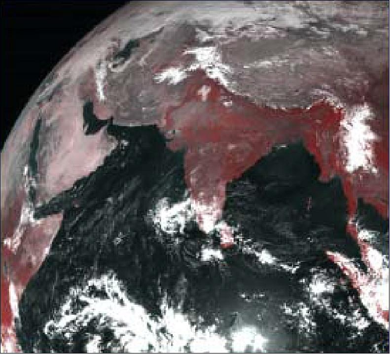
VHRR/2 is a modified version of the VHRR heritage imagers flown on INSAT-2A, -2B, and -2E. The VHRR/2 observes in VIS, water vapor and TIR bands providing a spatial resolution of 2 km in VIS band and 8 km for the rest. VHRR/2 was developed by SAC (Satellite Application Center), Ahmedabad, India. The instrument operates in three scanning modes:
• Full frame mode (20º North-South x 20º East-West), minimum in about 33 minutes covering the entire Earth disk
• Normal frame mode (14º N-S x 20º E-W), minimum in about 23 minutes
• Sector frame mode in which the sector can be positioned anywhere in steps of 0.5º in the N-S direction to cover 4.5º N-S x 20º E-W. This mode is particularly suited for rapid, repetitive coverage during severe weather conditions like a cyclone.
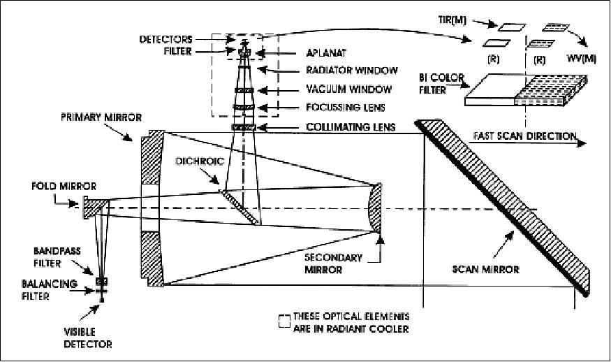
The nominal frame repetition rates are: 40, 30 and 20 minutes respectively. VHRR/2 is an optomechanical system (whiskbroom type imager). The incoming solar radiation is reflected onto a Ritchey-Chretien telescope of 20 cm aperture by a beryllium scan mirror mounted at 45º to the optical axis. The optical system includes a gold-film dichoric beam-splitter that transmits visible light energy and reflects WV/TIR energy, so that the radiation from the Earth is channelized to the visible and IR focal planes simultaneously.
The visible band detector configuration consists of two staggered arrays of four silicon photodiodes each; while two sets of mercury-cadmium telluride (MCT) detector elements operating nominally at 100-110 K sense the WV/thermal radiation. The scan mirror is mounted on a two-axis, gimballed scan mechanism system to generate a 2-D image by sweeping the detector instantaneous field of view (FOV) across the Earth's surface in east to west (fast scan) and north to south (slow scan).
Spectral band: VIS | 0.55 - 0.75 µm; Integrated out-of-band response <3% |
Spatial resolution VIS | 56 µrad (or 2 km x 2 km) |
Radiometric performance: SNR | > 6 for VIS at 2.5% albedo |
Dynamic range of TIR/MWIR channels | 4-340 K |
Misregistration between VIS and IR | < 56 µrad |
Modulation Transfer Function (MTF) | > 21% for IR and TIR; >23% for VIS channel |
Imaging mode | Coverage | Repeatability |
Full scan | 20º N-S and 20º E-W | 33 min |
Normal scan | 14º N-S and 20º E-W | 23 min |
Sector scan | 4.5º N-S and 20º E-W | 23 (3 times) |
Channel | No of detectors | MTF (Modulation Transfer Function) | Dynamic range | Noise performance |
VIS | 4 +4 redundant | > 0.23 approx. | 0-100% albedo | 6 : 1 min at 2.5% albedo |
Water Vapor (WV) | 1 + 1 redundant | > 0.21 approx. | 4-340 K | 0.25 K at 300 K |
TIR | 1 + 1 redundant | > 0.21 approx. | 4-320 K | 0.5 K at 300 K |
CCD Camera
The experimental instrument uses a linear CCD detector array with three spectral bands (see Table 5). Applications of the instrument data are in meteorology as well as in vegetation mapping. Of the three bands, the first two being similar to the NOAA AVHRR bands 1 and 2, provide "vegetation index" observation; the third band is used for snow-cover, snow-cloud discrimination and for aerosol measurements. A linear silicon array is used for the VIS and VNIR bands, while a InGaAs array is used for the SWIR band. The camera provides a nadir spatial resolution of <= 1 km in all three bands. The swath of the CCD Camera is 6300 km. The source data is coregistered and digitized to 10 bits. The data rate of the CCD Camera is 1.3 Mbit/s (QPSK modulation).
The CCD Camera was a first-time introduction on INSAT-2E. It permits greater accuracy in cyclone tracking and also affords monitoring of local severe storms. The requirements for the third-generation INSAT series call for a tandem operation, in which two members, INSAT-3A and -3D are earmarked for meteorology. While the INSAT-3A meteorological payload is still very similar to that flown on INSAT-2E (VHRR/2), the INSAT-3D payload will feature an enhanced VHRR instrument with six channels and a higher spatial resolution; two of the channels provide a split window for the TIR bands at 10.3-11.3 µm and 11.5-12.5 µm. This feature will be used to improve SST estimates.
Spectral bands | 0.62 - 0.68 µm,VIS band |
Spatial resolution | 1 km x 1 km |
MTF | <=0.23 |
Dynamic range | 0-100% albedo |
Noise performance | SNR <= 128 at 100% albedo |
Coverage | 6250 km x 300 km per scan line (max. number of lines = 31) |
Image repetivity | One scan line per minute |
Instrument mass, power | <55 kg, <50 W |
The CCD Camera consists of the following elements: scan mechanism assembly, optics and detector assembly, and camera electronics.
• Scan mechanism assembly: Features a gimballed scan mirror which sweeps FOV in two orthogonal axes. The fast sweep generates 300 video lines over a 6300 km east-west direction every minute (with a fast retrace capability). The 0.4º south stepping of the mirror after each east-west scan provides the generation of successive image strips. The TFOV (Total Field of View) of the mirror is ±13º in the E-W and ±10º in the N-S direction, while the actual image is ±5º in E-W and ±5º in the N-S direction. The actual image may be positioned anywhere within the mirror TFOV.
• Optics and detector assembly: The assembly consists of the scan mirror, telescope, dichroic beam splitters, fold mirror, lens doublet and bandpass filters. The front-end optics, namely scan mechanism and telescope, is identical to that of VHRR (except that the telescope performance has been upgraded to provide a FOV of ±0.25º at twice the spatial frequency of VHRR). The VIS and VNIR silicon CCD detectors have 2048 element linear arrays, as well as the InGaAs photodiode detector (cooled) for the SWIR band. The outputs of the three line arrays, providing a total of 900 pixels, are processed to construct 300 image pixels for each band.
• Camera electronics: The subsystem provides: a) clock and bias inputs to the detectors, b) processes and digitizes the detector outputs., c) formats the video signal along with auxiliary information, d) monitors the instrument; e) interfaces with other subsystems, and f) controls the SWIR detector temperature through a feedback loop.
DCS (Data Collection System)
The DRT (Data Relay Transponder) is part of a DCS (Data Collection System) of ISRO. The objective is to collect data from unattended meteorological platforms in the ground segment. DRT receives receives signals from unattended weather data collection platforms and retransmits them to the central station. The data from these payloads are being used for comprehensive weather status and forecasting.
RF communication of DRT: Uplink frequency = 402.75 MHz; downlink frequency = 4506.05 MHz; bandwidth = ± 100 kHz; EIRP = 21 dBW (min).
Note: MetSat-1 does not carry SASAR (Satellite Aided Search and Rescue) system. In the INSAT-2 series, the INSAT-2A and -2B satellites carried SASAR transponders as well as DRTs (Data Relay Transponders). According to ISRO information, INSAT-3A (launch April 9, 2003) and INSAT-3D (to be launched in late 2012), will carry SASAR and DRT payloads.
References
1) "INSAT-3A," ISRO, URL: http://www.isro.gov.in/Spacecraft/insat-3a
2) "CEOS EO Handbook-Agency Summary - ISRO," Updated for 2015, URL: http://database.eohandbook.com/database/agencysummary.aspx?agencyID=11
3) Report of the 42 nd Meeting of the Coordination Group for Meteorological Satellites (CGMS-42), Guangzhou, China, 19-23 May 2014, URL: http://www.cgms-info.org/documents/CGMSMR42_00_FullReport.pdf
4) Vinay K Dadhwal, "25 Years of Indian Remote Sensing Satellite (IRS) Series," Proceedings of the 50th Session of Scientific & Technical Subcommittee of UNCOPUOS, Vienna, Austria, Feb. 11-22, 2013, URL: http://www.oosa.unvienna.org/pdf/pres/stsc2013/tech-44E.pdf
5) Information provided by A. S. Kiran Kumar of ISRO/SAC, Ahmedabad, India
6) V. Rajeswara Rao, A.K. Sharma , P. C. Joshi, P. K. Pal, "Current Status of INSAT Meteorological Satellites," CGMS-38 (Coordination Group for Meteorological Satellites-38)New Delhi, India, Nov. 8-12, 2010, paper: IMD-WP-13, URL: ftp://ftp.eumetsat.int/pub/CPS/out/CGMS%2038%20report
/CGMS-38%20CD/Working%20Papers%20CGMS-38/IMD/CGMS-IMD-WP-13.pdf
7) P. C. Joshi, "Indian Meteorological Satellite Missions: Current & Ülanned," GOES-R User Conference, New Orleans, LA, USA, Jan. 23-24, 2008, URL: http://www.goes-r.gov/downloads
/GOES_Users_Conference_V/GUC_V_slides/231645%20GOES-R-presentation-PCJoshi.pdf
The information compiled and edited in this article was provided by Herbert J. Kramer from his documentation of: "Observation of the Earth and Its Environment: Survey of Missions and Sensors" (Springer Verlag) as well as many other sources after the publication of the 4th edition in 2002. - Comments and corrections to this article are always welcome for further updates (eoportal@symbios.space).