ISS: UrtheCast
EO
Multi-purpose imagery (ocean)
Mission complete
High resolution optical imagers
Quick facts
Overview
| Mission type | EO |
| Agency | Urthecast |
| Mission status | Mission complete |
| Launch date | 25 Nov 2013 |
| End of life date | 25 Nov 2016 |
| Measurement domain | Land |
| Measurement category | Multi-purpose imagery (ocean), Multi-purpose imagery (land) |
| Measurement detailed | Land surface imagery |
| Instrument type | High resolution optical imagers |
| CEOS EO Handbook | See ISS: UrtheCast summary |
ISS utilization: UrtheCast
First Generation Launch Mission Status Second Generation Instruments
Ground Segment References
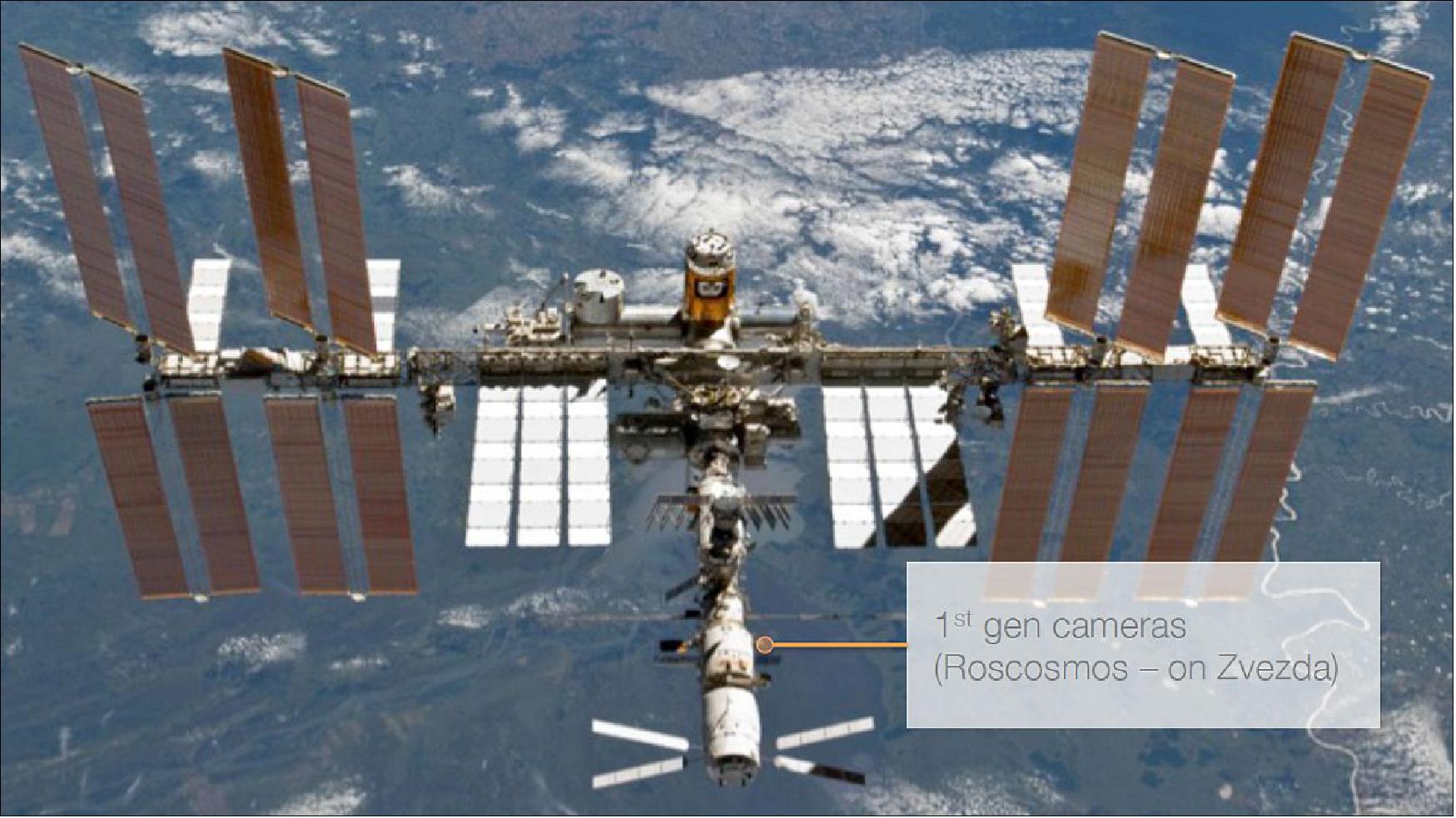
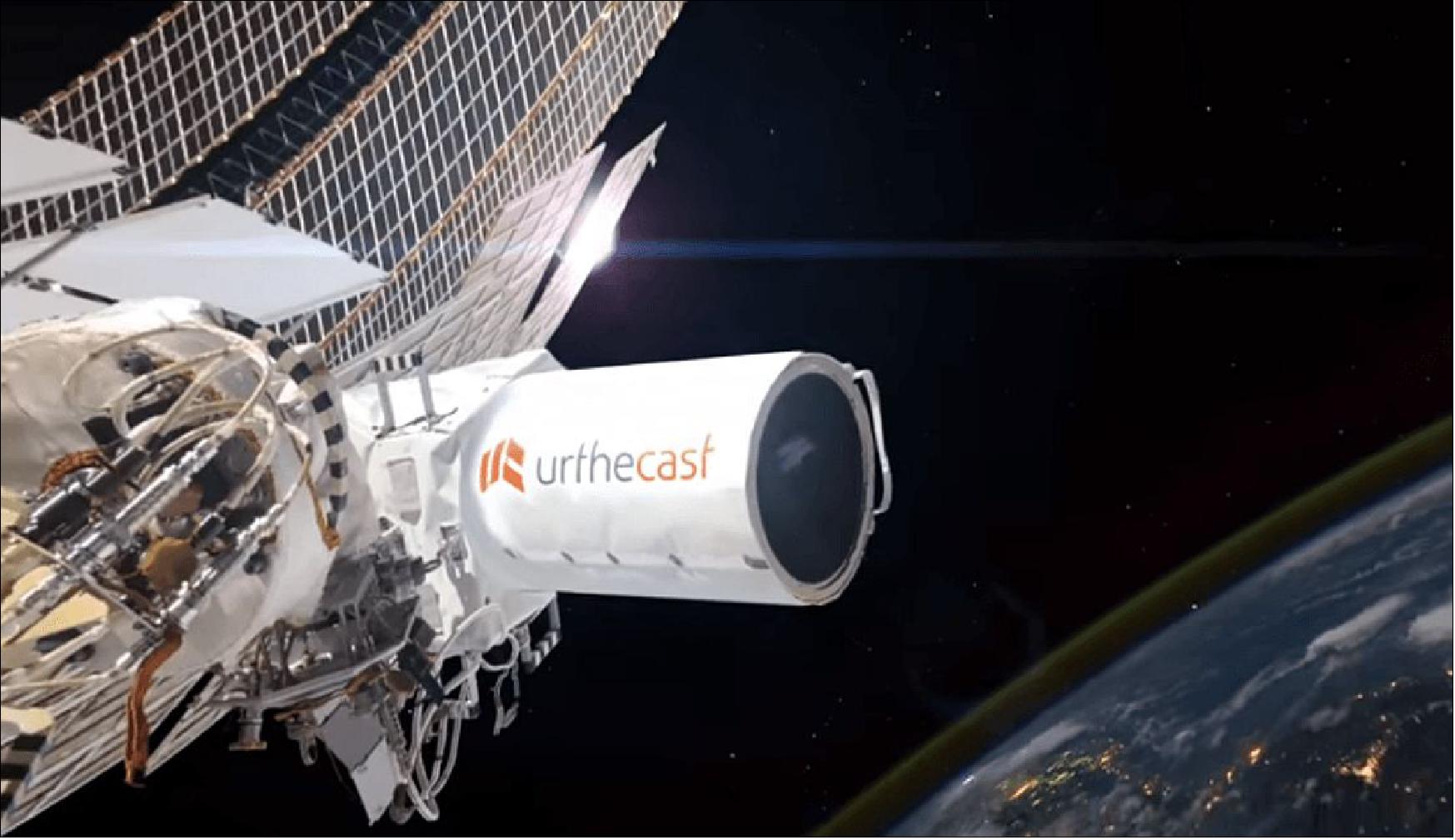
The company UrtheCast Inc. of Vancouver, BC, Canada is providing the world’s first live, high-definition video feed of Earth from space. With the help of prominent aerospace partners like RSC Energia, UrtheCast (pronounced 'EarthCast') is building, launching, installing, and operating two cameras onboard the International Space Station (ISS). UrtheCast was founded in 2010. Scott Larson is the UrtheCast Co-founder and CEO (Chief Executive Officer) while George Tyc is the CTO (Chief Technology Officer) of UrtheCast. - UrtheCast has established partnerships and agreements with various companies and organizations around the world. 1) 2)
The original idea for UrtheCast was simple: Place a couple of webcams onto the ISS and stream the images over the Internet. That was the plan before UrtheCast’s Russian partner, RSC Energia, offered to install the cameras on a moveable platform, attached to the space station’s Zvezda service module. UrtheCast executives then decided to replace one of the still cameras with a video camera.
In Oct. 2011, RSC Energia and the Russian space agency, Roscosmos, approved preliminary plans to install the UrtheCast cameras on the space station.
The camera systems to be operated by UrtheCast are part of an international project involving several nations, primarily Russia (through the Russian Space Agency), Canada and the United Kingdom. The UrtheCast service will be accessible online and will allow users to access the two UrtheCast cameras from their homes to examine places or events.
In October 2014, UrtheCast outlined plans to install a second-generation payload, namely a remote sensing camera system and a radar imaging payload on the ISS Tranquility module in 2017 to be launched by the SpaceX Dragon cargo ship. 3)
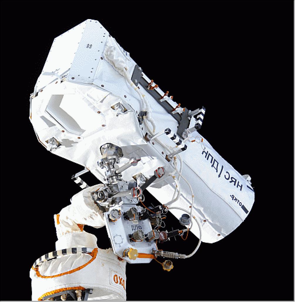
First Generation Cameras
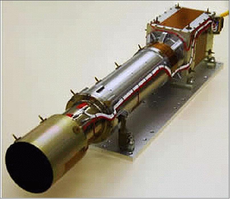
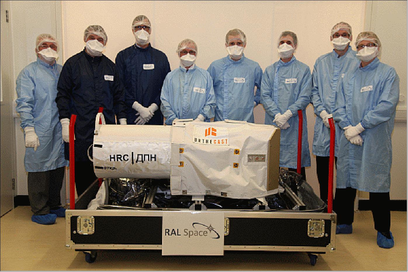
RAL Space, part of the STFC/RAL (Science and Technology Facilities Council/Rutherford Appleton Laboratory), Chilton-Didcot, UK, designed and developed the two high definition cameras for UrtheCast Inc., one medium resolution and one high resolution. 4)
1) MRC (Medium Resolution Camera): The MRC takes still images while the HRC (High Resolution Camera) captures video that shows detail with a spatial resolution of 1m, which is similar to imagery of Google Earth. To ensure they’re pointing in the right direction, and to cope with vibrations on the Space Station, the cameras will be linked to star trackers for a better pointing accuracy.
The MRC is essentially a modified version of RALCam-3, an existing and reliable space camera. The MRC will be pointed directly down and take continuous images of Earth in ~50 km swaths at a resolution of ~6 m . RALCam-3 is a pushbroom imager operating in four wavebands in the visible and near infrared, allowing color images of the Earth's surface to be built up. The camera has a simple all-refractive optical design, well-matched to its resolution requirements without the complexity, mass and expense of a mirror system. 5) 6)
The optical design of the camera was carried out within the optical systems group. The camera’s lens system was designed using radiation stabilized glasses, meaning that it is not vulnerable to the changes in transmission which can afflict standard optical glasses in the space radiation environment.
The camera electronics were designed within the electronics group. The industry standard SpaceWire protocol is used for commanding and image download and a fully specified user interface allows programming of the camera to select parameters such as exposure time and image size. The camera contains an 8800 element linear CCD plus all of the electronics necessary to drive the detector and read out the image.
Imager type | Pushbroom mode observations |
Focal length | 46 cm |
Spectral bands (4) | R, G, B, NIR |
GSD (Ground Sample Distance) | 5 m GSD (Ground Sample Distance) from an orbital altitude of 400 km |
Swath width | ~50 km |
Detector array assembly | 4 linear Kodak KLI-8800 linear CCD arrays, 7 µm pixels |
Instrument mass, power | 10 kg, 20 W |
Instrument size | 750 mm x 145 mm x 145 mm |
RAL Space developed the MRC instrument already in the 2008 timeframe, funded by the British and Norwegian governments for environmental monitoring. 7) — The RALCam-3 imager will also be flown on the Amazonia-1 mission of INPE, Brazil on a sun-synchronous orbit of 752 km altitude. Plans for Amazonia-1 development existed already in 2008, but according to current estimates, the Amazonia-1 spacecraft will not be launched before the end of 2016. 8)
UrtheCAST named the MRC (Medium Resolution Camera) Theia.
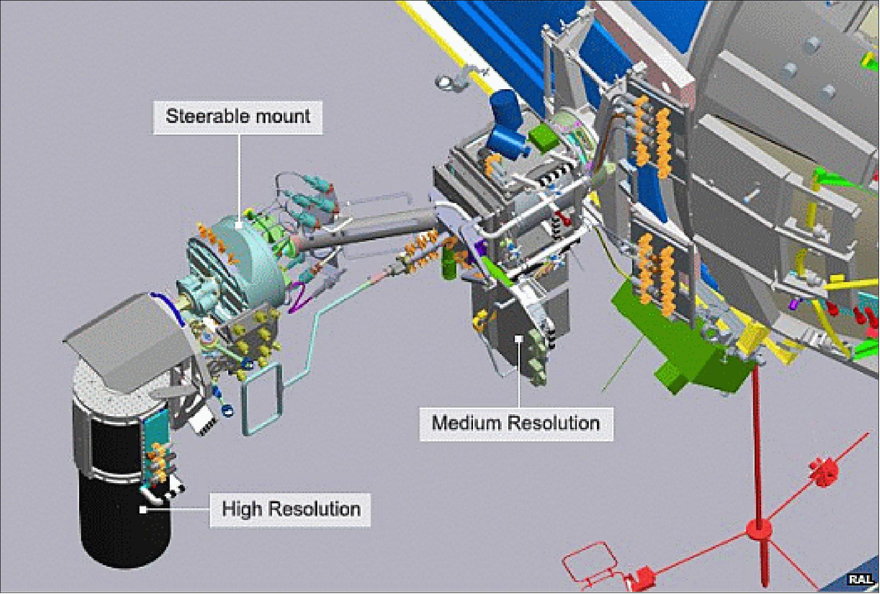
2) HRC (High Resolution Camera): The HRC instrument is a video camera mounted on a steerable platform. The RAL Space cameras interface with the data handling electronics, built by MDA in Vancouver, Canada, which pass the data through the ISS systems down to the ground where Urthecast make the images available for streaming to their customers and to the public. The HRC can also be controlled to continuously aim at a single point on the Earth’s surface as the ISS passes overhead which allows the HRC to generate a video stream instead of single images. 9) 10) 11)
The cameras will capture raw data and compress it using the JPEG2000 algorithm. Data from each camera will then be stored on a computer and transmitted when the ISS is in sight of a receiver station on the ground. This will happen at least once per orbit, or every 90 minutes.
From the ground stations, the data will be uncompressed and uploaded to servers. On the UrtheCast website, the user will be able to fast-forward, pause, rewind and skip the near-live footage.
By early 2013, UrtheCast plans to complete installation of the cameras and associated hardware on the Zvezda service module so the company can begin capturing imagery, compressing the data and sending them directly to ground stations through a high-speed X-band downlink on the Russian segment of the space station. UrtheCast plans to process the data on the ground before broadcasting it on the Web. That means viewers will see images somewhere between “a few minutes and a couple of hours” after they are captured by space-based cameras. 13) 14)
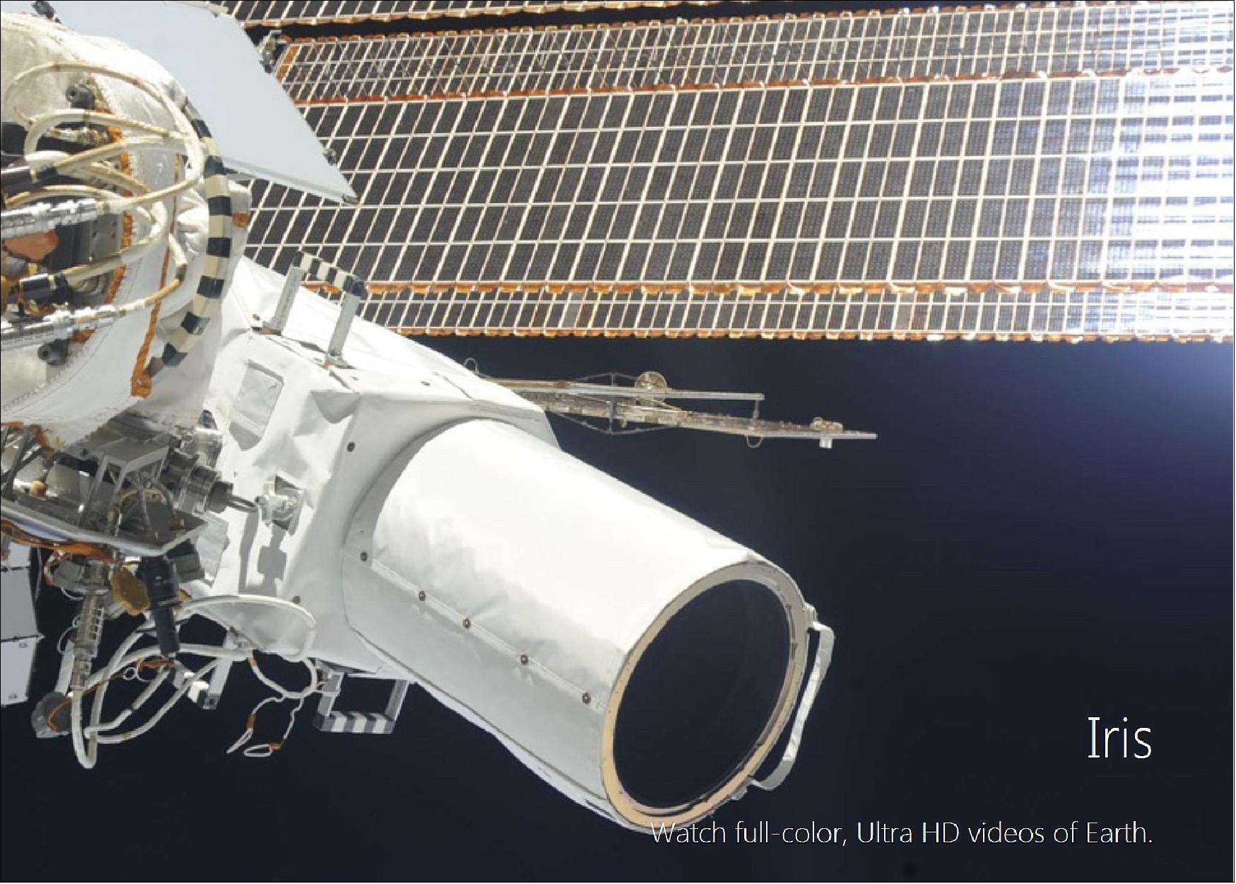
UrtheCast nicknamed the HRC (High Resolution Camera), a video instrument, Iris. Iris is mounted on a bi-axial pointing platform that allows for the tracking of targeted AOI (Areas of Interest). Iris uses a CMOS detector to capture full color, UHD (Ultra High-Definition) videos with a GSD (Ground Sample Distance) as fine as 1 m and a duration of up to 60 seconds. OrthoView uses image frames that have been fully ortho-rectified, providing the impression of a view that's directly overhead, with features on the ground appearing fixed.
Video imaging duration | Up to 60 seconds |
Incidence angle | < 40º |
Frame rate | 30 frames/s |
Frame format | 4096 x 20 pixels (UHD); 1920 x 1080 pixels (HD) |
GSD (Ground Sample Distance) | Resampled to 1 meter |
Aspect ratio | 16:9 |
Framing method | Center point |
Frame coverage | Approximately 3.8 km x 2.2 km (UHD); Approximately 1.9 km x 1.1 km (HD) |
Processing level | Orthorectified |
Resampling Kernel | Cubic convolution |
Dynamic range | 16 bit |
Video format | Ultra High Definition and High Definition (H.264 encoding) |
File format | MPEG-4 |
Launch
The cameras were launched on Nov. 25, 2013 (20:53:06 UTC) on the Progress M-21M (Progress 53P) cargo spacecraft from Baikonur, which docked with the station on November 29, 2013.
Orbit: Near-circular orbit of the ISS, altitude in the range of 360-460 km, inclination = 51.6º, 16 revolutions/day.
Note: The inclination of the orbit states, what regions of the Earth can be covered (i.e. observed by the cameras on ISS), namely those land masses inside ±51.6º.
Camera coverage: The cameras will constantly be rolling as the ISS circles the world, 16 times a day. They will capture video and imagery below the Station’s orbit, where approximately 90% of the world’s population lives.
- UrtheCast’s 5 -6 m resolution camera will capture any location that the ISS passes over, generating large strips of imagery, up to 50 km wide.
- UrtheCast’s 1 m resolution video camera will capture up to 150 videos of Earth in 4k resolution — Ultra HD. Depending on flyover conditions, the video length will generally be 60 seconds long.
Mission Status
• April 21, 2021: Private equity firm Antarctica Capital has formed a Canadian optical satellite imagery provider called EarthDaily Analytics, after buying parts of UrtheCast that sought creditor protection last year to avoid bankruptcy. 16)
- A company official for New York-based Antarctica Capital, which manages more than $2 billion of assets, told SpaceNews it is in talks about buying other businesses in complementary areas.
- It has partnered with space industry advisory firm ArgoSat Advisors to create Antarctica Data Partners, which is hunting for disruptive companies that use data analytics, cloud technology, artificial intelligence (AI) and machine learning capabilities.
- Antarctica Capital acquired UrtheCast satellite designs, its customer-facing Geosys agriculture software business, midstream and downstream processing technology, customer contracts and related intellectual property.
- Vancouver-headquartered EarthDaily aims to use these assets to start building a constellation in the middle of this year, aiming to be operational before the end of 2023.
- Drawing on a development program that UrtheCast started in 2016, EarthDaily’s constellation data will feed into analysis that Geosys currently provides from third-party satellites.
- The Antarctica Capital official declined to comment on the constellation design or suppliers, but said it is optimized for automated processing in the agriculture market.
- “Our imager architecture is quite different from the more typical small [Earth observation] satellites that are optimized for spatial resolution in mapping or defense applications,” the official said.
- Agriculture customers use Geosys to manage risks and improve profitability for applications including crop production monitoring.
- Don Osborne, CEO of EarthDaily Analytics, said in a statement: “Use of technology in the agriculture industry optimizes production and improves sales and profitability and we want to be at the forefront of that expanding opportunity. We are excited to partner with Antarctica Capital to realize the transformative potential of our technology.”
- Scott Larson, who co-founded UrtheCast and was once its CEO, formed a Toronto-based company called Alpha Insights to buy the synthetic aperture radar (SAR) assets that Antarctica Capital carved out of its deal.
- Antarctica Capital also did not buy the Earth-imaging cameras that UrtheCast had installed on the International Space Station. That is where UrtheCast’s business was originally focused, but it ran into issues as the relationship with its Russian operating partner broke down.
- “Our focus is on the EarthDaily business for the provision of high-quality data products and analytics derived from optical imaging, especially for digital agriculture,” the Antarctica Capital official said.
- UrtheCast started developing a data and analytics business after buying two Deimos satellites in 2015.
- Two years later, while UrtheCast was in the middle of another financial restructuring, it acquired Geosys from U.S. dairy giant Land O’Lakes.
- As it struggled to meet payments, COVID-19 helped push UrtheCast into restructuring proceedings in 2020 under Canada’s Companies’ Creditors Arrangement Act (CCAA).
- Before UrtheCast filed for protection, it had been trading on the Toronto Stock Exchange since 2013.
- While EarthDaily Analytics is a new entity that is not in creditor protection, UrtheCast Corp remains in bankruptcy proceedings in Canada.
- Antarctica Capital also did not buy the two Deimos satellites, according to the company.
- Chandra Patel, Antarctica Capital’s managing director, said in a statement: “We look forward to providing management operational support and technical oversight by applying the expertise of the Antarctica Data Partners team.
- “As we move forward with the company’s new constellation of satellites with state-of-the-art imaging technology, we see tremendous opportunity enabled by combining the company’s software and data analytics platform with the new satellite constellation. This combination will permit the company to offer its customers unparalleled frequency and affordability of data and allow it to expand beyond agriculture into multiple untapped verticals including ESG and Defense and Intelligence.”
• October 24, 2020: UrtheCast filed for bankruptcy. In Canada this process it is called “the Companies’ Creditors Arrangement Act (CCAA).” The filing was made on Sept. 4. Ernst & Young Inc. is the court-approved monitor for the proceedings. 17)
- The debut of “Opti-SAR” was their last desperate act to find funding which never materialized. Traction from space startups Capella Space, ICEYE and Umbra Lab made it all but impossible for Urthecast to find funding. Urthecast also received pressure from optical providers BlackSky, Planet and Maxar’s Leagon constellation.
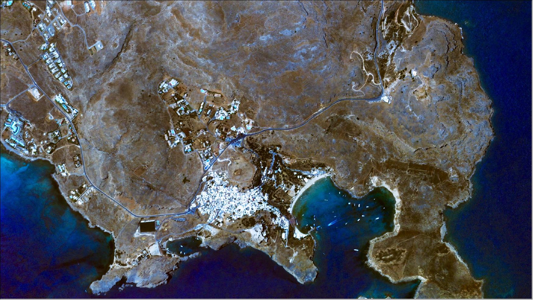
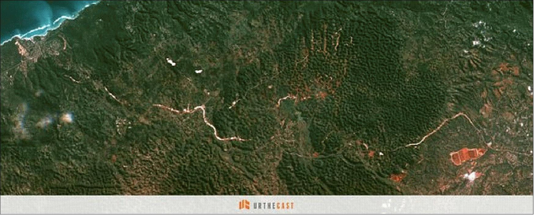
• January 15, 2016: Now that’s a first. After acquiring an Iris video of this popular archeological site in Greece — the Acropolis of Lindos — our processing team spotted something peculiar: a waterskier swerving to and fro behind a speedboat. The village of Lindos, located on the island of Rhodes in the Aegean Sea, provides the perfect setting for water sports. 18)
• January 11, 2016: UrtheCast became the latest company to lend its immense earth observation capacity to conservation efforts. In partnership with GFW (Global Forest Watch), UrtheCast is providing free access to high-resolution satellite imagery—15 m pansharpened Landsat-8 imagery, 22 m Deimos-1 imagery and 5 m Theia imagery—through the GFW platform. 19) 20)
- The new GFW feature goes far beyond standard satellite imagery basemaps, providing new images daily and allowing users to sort by filter, maximum cloud cover percentage and date range. UrtheCast imagery on GFW goes back to early 2013 and will be updated as new images are acquired, with some imagery captured in 2016 already on GFW. GFW users will also eventually be able to subscribe to receive email updates when new images for their areas of interest are acquired.
- Around 30% of the Earth is covered in forests, and accurately monitoring such a huge area requires information with both wide coverage and great detail. Large-scale public satellite programs help scan forests rapidly at medium and coarse resolutions, but to really understand how a forest is changing, or to identify the drivers of deforestation, you need high-resolution satellite images that reveal what is really happening on the ground. Forest managers have traditionally lacked the latter—less than a decade ago, even a moderate-resolution image could cost thousands of dollars, rendering this powerful resource too expensive for academics and the public.
- That all changed when NASA and USGS began releasing their Landsat archives for free in 2008. The Landsat archives featured a 35-year record of Earth surface imagery, setting a new bar for transparency in observing changes to the environment. However, Landsat is a moderate resolution sensor, better suited for monitoring broad trends than examining individual locations.
- The release of UrtheCast images on the GFW platform changes the game again, creating new opportunities to analyze critical information about specific environmental issues, including deforestation. GFW users can now track and verify deforestation with an unparalleled degree of detail. Complementing GFW’s data sets and alert systems with timely high-resolution imagery opens the door to accurately monitor environmentally impacting activities, like clearing in the last of Cambodia’s remaining primary forests for rubber plantations or illegal gold mining in Madre de Dios, Peru.
• In Nov. 2015, UrtheCast announced it is refocusing its investment away from International Space Station-mounted cameras toward a planned constellation of Earth-imaging satellites. UrtheCast had been investing in a second-generation camera system for the space station, but has shifted focus to prepare for a 16-satellite constellation of eight optical and eight SAR (Synthetic Aperture Radar) satellites in LEO (Low Earth Orbit), all to be built by small-satellite specialist SSTL (Surrey Satellite Technology Ltd.),UK. 21)
- The second-generation camera system for the space station — a dual-mode camera plus a synthetic aperture radar — will now be put on hold to support development of the constellation.
- The high-resolution Iris video camera’s pointing platform — provided by UrtheCast partner RSC Energia of Kaliningrad, Russia — was defective and required new cabling and a software patch.
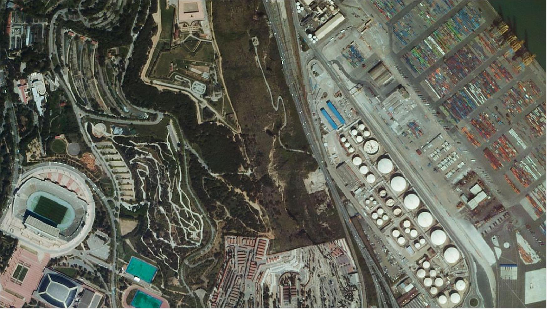
• The image of Figure 7 was released by UrtheCast on Sept. 29, 2015. 22)
• On Sept. 18, 2015, UrtheCast was awarded the Euroconsult prize for ‘Strategic Transaction of the Year’ during the 'Summit on Earth Observation Business' in Paris, as part of the World Satellite Business Week Event. Euroconsult’s Annual Earth Observation Business Awards recognize companies that are transforming and driving the satellite industry, contributing to its growth and innovation. 23)
• July 15, 2015: The UrtheCast Corporation today acquired the Earth Observation business Deimos Imaging from Elecnor, S.A. (Spain) for an aggregate price of €76.4 million. In addition to ownership and operation of the Deimos-1 and Deimos-2 satellites, UrtheCast has acquired satellite operations related to the collection, storage, processing, analysis, distribution, and licensing of imagery captured by these and other satellites. The combination of UrtheCast and Deimos operations is expected to significantly accelerate UrtheCast’s strategies related to distribution, web platform development, and the building out of the UrtheCast Constellation. 24) 25)
- In conjunction with the Acquisition, UrtheCast has entered into a Mutual Cooperation Agreement with Deimos Space, S.L.U. ("Elecnor Deimos"). This agreement contemplates the participation of Elecnor Deimos as a strategic implementation partner for UrtheCast's planned 16-satellite constellation consisting of both optical and SAR instruments. Elecnor Deimos will join the other strategic partners expected to be involved in UrtheCast's constellation, which includes various Canadian companies expected to build elements of the SAR payload, as well as SSTL (Surrey Satellite Technology Ltd.), UK for the spacecraft platforms and optical payload (Ref. 25).
• On June 22, 2015, UrtheCast announced that its subsidiary has entered into a definitive agreement with Elecnor, S.A. ("Elecnor") to acquire Elecnor's Earth Observation business Deimos Imaging. To carry out the Acquisition, UrtheCast's wholly-owned subsidiary, UrtheCast International Corp., has entered into a share purchase agreement with Elecnor and Deimos Space, S.L.U. to acquire the outstanding shares of Deimos Imaging, S.L.U. and DOT Imaging, S.L.U. DOT-Deimos owns and operates two satellites, Deimos-1 and Deimos-2.
The acquired business of DOT-Deimos comprises the Earth Observation ("EO") satellite and imagery business of Elecnor, a publicly traded Spanish engineering and infrastructure company, which has been producing imagery since the launch and commissioning of the Deimos-1 satellite in 2009. The business consists of, among other things, the ownership and operation of the Deimos-1 and Deimos-2 EO satellites and the collection, storage, processing, analysis, distribution and licensing of the EO imagery captured by these and other satellites. DOT-Deimos has an established customer base across Europe and Latin America, including ESA (European Space Agency), European governmental agencies and commercial customers in the agricultural, forestry and land use industries, among others. Upon closing the Acquisition, UrtheCast will also own the full imagery archive utilized by the acquired business, which currently consists of ~6.5 billion km2.
The Deimos-1 satellite was launched in 2009 and provides 22 m resolution images at 10 bits with a swath width of 650 km. Deimos-1 has a collection capacity of more than 5,000,000 km2/day, with a three-day average revisit time worldwide. The Deimos-2 satellite was launched in 2014 and provides 75 cm pan-sharpened images with a swath width of 12 km. Deimos-2 has a collection capacity of more than 150,000 km2/day, with a two-day average revisit time worldwide.
The combination of UrtheCast and DOT-Deimos is expected to allow UrtheCast to accelerate its own strategy. UrtheCast believes this will be achieved through the use of Deimos' imagery archive on UrtheCast's web platform, distributing fresh imagery through UrtheCast's established distribution channels, customers and web platform, leveraging each company's established relationships and building upon each other's infrastructure.
In addition, UrtheCast and Deimos Space have signed a Mutual Cooperation Agreement that will allow both companies to look for opportunities in the market for the benefit of both companies. Deimos Space will be the exclusive provider for receiving stations for the Deimos-1 and Deimos-2 satellites. Also, under this agreement, the companies will work together on UrtheCast's recently announced optical and SAR satellite constellation in the areas of the headquarter mission control center, direct tasking and receive ground stations, mission analysis and flight dynamics, and in the integration and testing of the SAR payloads.
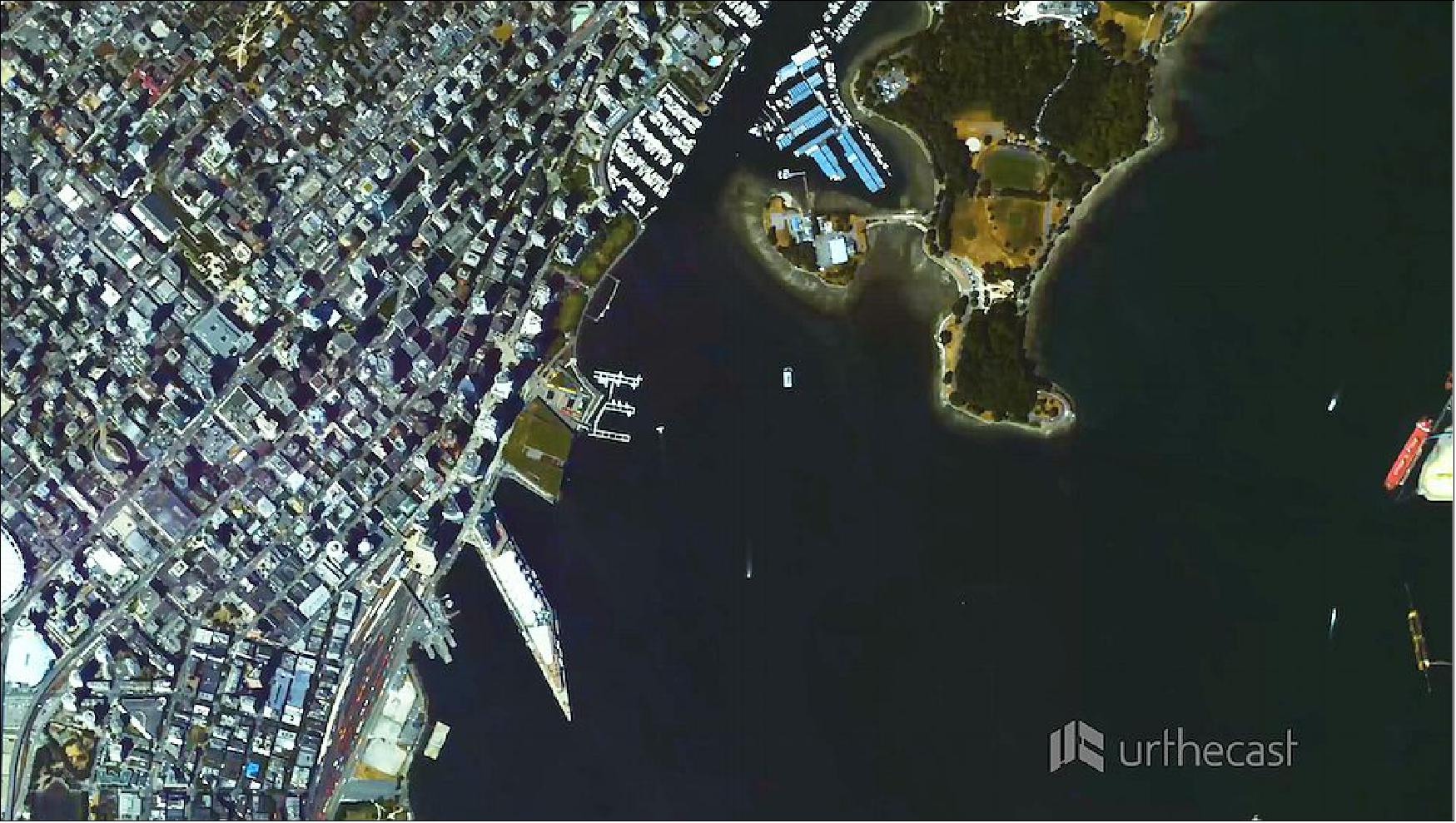
• June 17, 2015: Today, UrtheCast released the world’s first, full-color HD videos of Earth, filmed from the ISS (International Space Station) at roughly 1m resolution. These videos of London, Boston, and Barcelona showcase life on Earth as viewed from the International Space Station, revealing the diverse utility of UrtheCast’s technology. 27)
- “Today, we are continuing our advancement towards democratizing the Earth Observation industry, making timely Earth video and imagery from space accessible to everyone,” explained Scott Larson, UrtheCast Co-founder and Chief Executive Officer. “With the ultimate goal of connecting the planet and highlighting what unites us all, we’re revealing a perspective of Earth from space that was previously reserved for a small few. By opening up our API to the web development community, we’re providing collaboration tools that will help people monitor, protect, and benefit our world and will lead to the democratization of Earth Observation imagery.”
- The videos of the Iris camera (see Ref. 27), ranging in length from 34 to 47 seconds, and covering areas of up to 1.92 km x 1.08 km, Iris has captured full-color HD data that is, as of yet, unparalleled.
• May 12, 2015: UrtheCast Corporation announced that footage captured from its two cameras aboard the International Space Station will be incorporated into a first-of-its-kind short film for the 2015 Pepsi® Challenge™ global campaign. Challenging live production conventions, UrtheCast’s Ultra HD video of worldwide locales will help to make this an unprecedented brand partnership, which combines the worlds of technology, music, film production and storytelling like never before. 28)
- To be released this fall, the short film will be shot from multiple locations and perspectives – both on Earth and in space. Designed to unite and inspire generations around the world as part of the #PepsiChallenge, Pepsi will invite consumers to participate in this unique film phenomenon. Filming will take place in more than 10 countries across four continents where thousands of consumers will join together to be filmed by UrtheCast’s proprietary HD video camera – permanently and impressively leaving their mark on history as part of this once-in-a-lifetime experience.
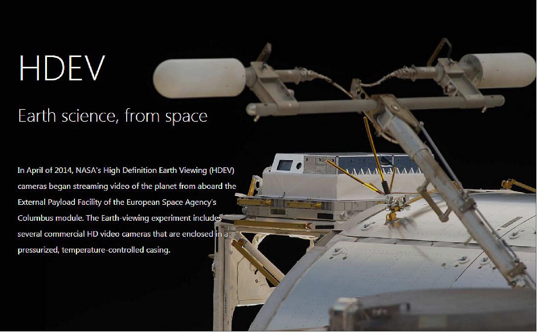
• April 23, 2015: UrtheCast announced that it has teamed with NASA to stream realtime Earth video data from NASA’s HDEV (High-Definition Earth-Viewing System) aboard the ISS to UrtheCast’s interactive web platform. This summer the live video data feeding will begin from the HDEV cameras to UrtheCast’s web platform, its interactive hub of Earth video and imagery. 29)
- The HDEV experiment aboard the ISS was activated April 30, 2014. It is mounted on the External Payload Facility of the European Space Agency’s Columbus module. This experiment includes several commercial HD video cameras aimed at the Earth, which are enclosed in a pressurized and temperature controlled housing. While the experiment is operational, views will typically sequence through the different cameras.
• November 24, 2014: UrtheCast Corp. announced that it has received the final signature on a five-year contract with a confidential customer, valued at US$65 million, for the provision of engineering services, value-added services, and Earth imagery data. A significant proportion of the contract’s value will be allocated for engineering and value-added services, to be provided by UrtheCast over the first three years of the contract term. 30)
- UrtheCast Corp. also reports that there has been a delivery of cables to the ISS, allowing for the in-orbit implementation of a solution for its BPP (Bi-axial Pointing Platform) — which will enable the HRC (High-Resolution Camera) to point in the direction of its targets and keep its field of view stable. These cables were launched and delivered to the ISS on November 23, 2014, aboard a manned Russian Soyuz mission.
• Oct. 1, 2014: UrtheCast Corp. announced that it has acquired access to the TDRSS (Tracking and Data Relay Satellite System) for the purpose of increasing its data downlink capacity and speed. As a robust constellation of communication satellites and ground stations for space communication, it is designed to increase the time spacecraft are in communication with the ground and improve the amount of data that can be transferred. TDRSS will allow UrtheCast to significantly augment both data collection and delivery to its current and future data clients. 31)
- The access to TDRSS was acquired through the UrtheCast partner NanoRacks LLC, a commercial provider of hardware and services for the U.S. National Laboratory onboard the ISS, pursuant to the Space Act Agreement of NanoRacks with NASA. After implementation, UrtheCast anticipates that it will begin delivery of some of its data via TDRSS in late 2014 or early 2015.
• July 16, 2014: UrtheCast Corp. announced that pursuant to its agreement with NanoRacks, LLC, it plans to dramatically expand its Earth Observation data stream by operating state-of-the-art sensors on the NASA segment of the ISS (International Space Station). UrtheCast intends to develop and supply the EO sensors, electronics and all related hardware. NanoRacks, working with the U.S. National Lab manager CASIS, will facilitate the launch, installation and onboard integration of the cameras and hardware in accordance with its Space Act Agreement with NASA. 32) 33)
- UrtheCast intends to develop two Sensors, a high resolution dual-mode optical/video camera and a high resolution dual-band SAR (Synthetic Aperture Radar) instrument, which will complement its current sensors aboard the ISS. The co-location of these sensors will allow for new EO products that are not currently available to the market. The sensors and their components are scheduled to launch to the ISS in 2016, and it is anticipated that the data will be available in 2017.
• July 16, 2014: UrtheCast provided an update on the commissioning process for its MRC (Medium-Resolution Camera) or “Theia” and its Ultra HD, HRC (High-Resolution Camera) or “Iris”. The MRC has achieved IOC (Initial Operational Capability), completing the MRC’s commissioning phase. Theia is now capable of commercial imaging and UrtheCast will continue to refine the operational and processing systems required to meet increased order volumes and produce value-added consumer products and services. 34)
- UrtheCast is continuing commissioning and calibrating the HRC. The BPP (Bi-axial Pointing Platform), which controls the pointing of the HRC, is experiencing difficulties in achieving the pointing control precision needed for the HRC to meet image quality specifications. The UrtheCast engineering team together with RSC Energia believes it has developed a solution to this problem using existing gyroscopes on the HRC to improve the BPP pointing control. This solution has been successfully tested on the ground. The on-orbit implementation of this solution requires software updates and the installation of additional cabling inside the Zvezda module. These new cables need to be delivered to the ISS (International Space Station). As a result, there will be a several month delay in commissioning the HRC.
• April 14, 2014: UrtheCast Features First Light Images At GEOINT 2013. 35)
• On April 3, 2014, UrtheCast released the first Earth imagery, captured by UrtheCast’s MRC (Medium Resolution Camera) onboard the ISS (International Space Station). 36) 37) 38)
The MRC, also referred to as “Theia”, is a multispectral, nadir-pointing imager that captures still imagery of 6 m resolution on a swath of ~50 km, which will be made commercially available on the UrtheCast platform. While the images will be made available on an individual basis, they will also be processed and constantly streamed to the UrtheCast platform. This will be realized on the interactive platform as a near real-time flyover view of the planet directly below the ISS as it orbits the globe 16 times every day.
In preparation for the unveiling of its full color, Ultra HD Earth video from space, UrtheCast remains focused on the commissioning and calibration of its cameras, in addition to ground system testing and the continuation of its business plan.
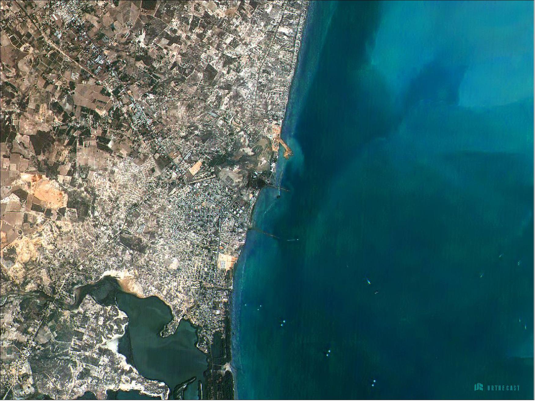
Legend to Figure 13: The image is centered around the town of Moneague, Jamaica, and has a 6 m GSD (Ground Sampling Distance). The photo has approximately 3200 x 8000 pixels, and covers an area of about 300 km2.
• On Feb. 18, 2014, UrtheCast announced that its two cameras have successfully passed initial functional testing. 39)
- HRC (High Resolution Camera) will produce 1 m resolution, full color videos.
- MRC (Medium Resolution Camera) will produce 6 m resolution imagery on a swath width of 50 km.
The engineering teams from UrtheCast and RSC Energia have confirmed that camera data from both the MRC and HRC can now be successfully captured and stored in a Data Handling Unit of UrtheCast onboard the ISS, and downlinked to the ground station in Moscow. Initial test imagery has been acquired from the MRC, which is being used to support the analysis and calibration of the camera. The team also continues to commission and calibrate the HRC’s precision pointing platform, which is required before test imagery can be acquired by the HRC.
With both cameras functioning as anticipated, the UrtheCast team is now focusing on further commissioning and calibration of the cameras and the pointing platform for the HRC. This will allow UrtheCast to unveil the first official full color, Ultra HD video, which is expected in Q2 2014.
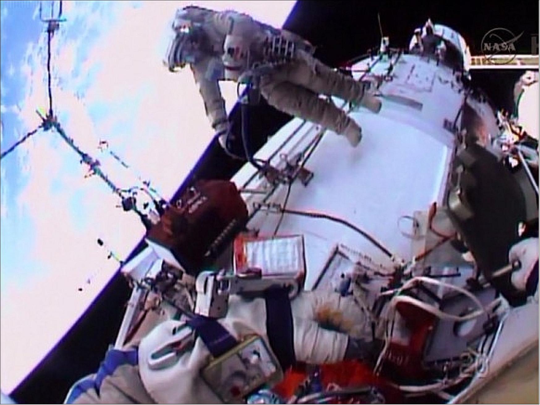
• On January 28, 2014, UrtheCast announced that its two Earth imaging cameras have been successfully installed on the Russian segment of the ISS (International Space Station). On Jan. 27, cosmonauts Oleg Kotov and Sergey Ryazansky performed a spacewalk (EVA-37a) to reinstall the two UrtheCast cameras that were previously installed and removed during a spacewalk on Dec. 27, 2013 (EVA-37). 40)
• On December 30 2013, UrtheCast announced that on Dec. 27, 2013, its two Earth observation cameras were installed as planned on the outside of the ISS. However, Mission Controllers were unable to confirm that the cameras were receiving power from the ISS. As a safety precaution, the cameras were removed and re-stowed inside the ISS pending resolution of the problem. 41)
• In January 2014, Expedition 38 spacewalkers Oleg Kotov and Sergey Ryazansky were again trying to install the cameras outside the station for UrtheCast to provide live views of Earth to subscribers. The cosmonauts’ first attempt on Dec. 27, 2013 showed telemetry problems, at which point the spacewalkers were instructed to bring the cameras back inside. 42)
The cosmonauts translated to the Zvezda service module and installed a high-resolution camera and a medium-resolution camera to capture Earth imagery. However, the medium resolution camera again experienced telemetry issues. Kotov and Ryazanskiy spent six hours, eight minutes outside performing this and other routine tasks, marking the fourth spacewalk in about a month for Expedition 38.
Second-Generation Instruments
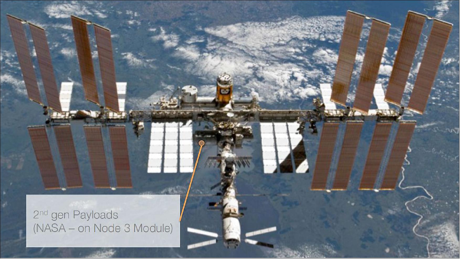
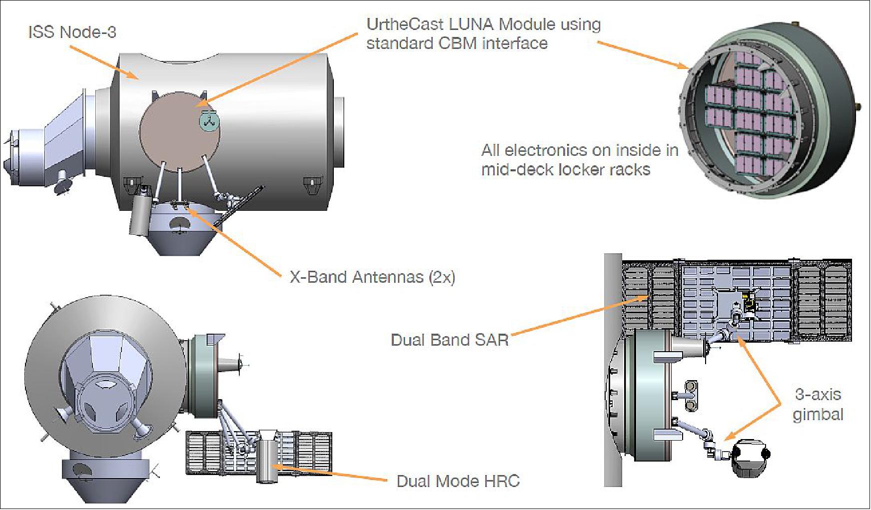
UrtheCast’s Second-Generation state-of-the-art Earth Observation (EO) remote sensing platform will be hosted onto the NASA segment of the ISS (International Space Station). This platform comprises a high-resolution dual-mode (pushbroom and video) optical camera and a dual-band (X and L) Synthetic Aperture Radar (SAR) instrument. These new sensors will complement the first-generation medium-resolution pushbroom and high-definition video cameras that were mounted onto the Russian segment of the ISS in early 2014. 43)
The new cameras are expected to be launched to the ISS in late 2017 via the SpaceX (Space Exploration Technologies Corporation) Dragon spacecraft. The Canadarm2 will then be used to install the remote sensing platform onto a CBM (Common Berthing Mechanism) hatch on Node 3, allowing the sensor electronics to be accessible from the inside of the station, thus limiting their exposure to the space environment and allowing for future capability upgrades.
The UrtheCast second-generation system will be able to take full advantage of the strengths that each of the individual instruments offers, such that the data exploitation capabilities of the combined instruments is significantly greater than from either instrument alone. This represents a truly novel platform that will lead to significant advances in many other Earth Observation applications such as environmental monitoring, energy and natural resources management, and humanitarian response, with data availability anticipated to begin after commissioning is completed in early 2018.
Space Segment
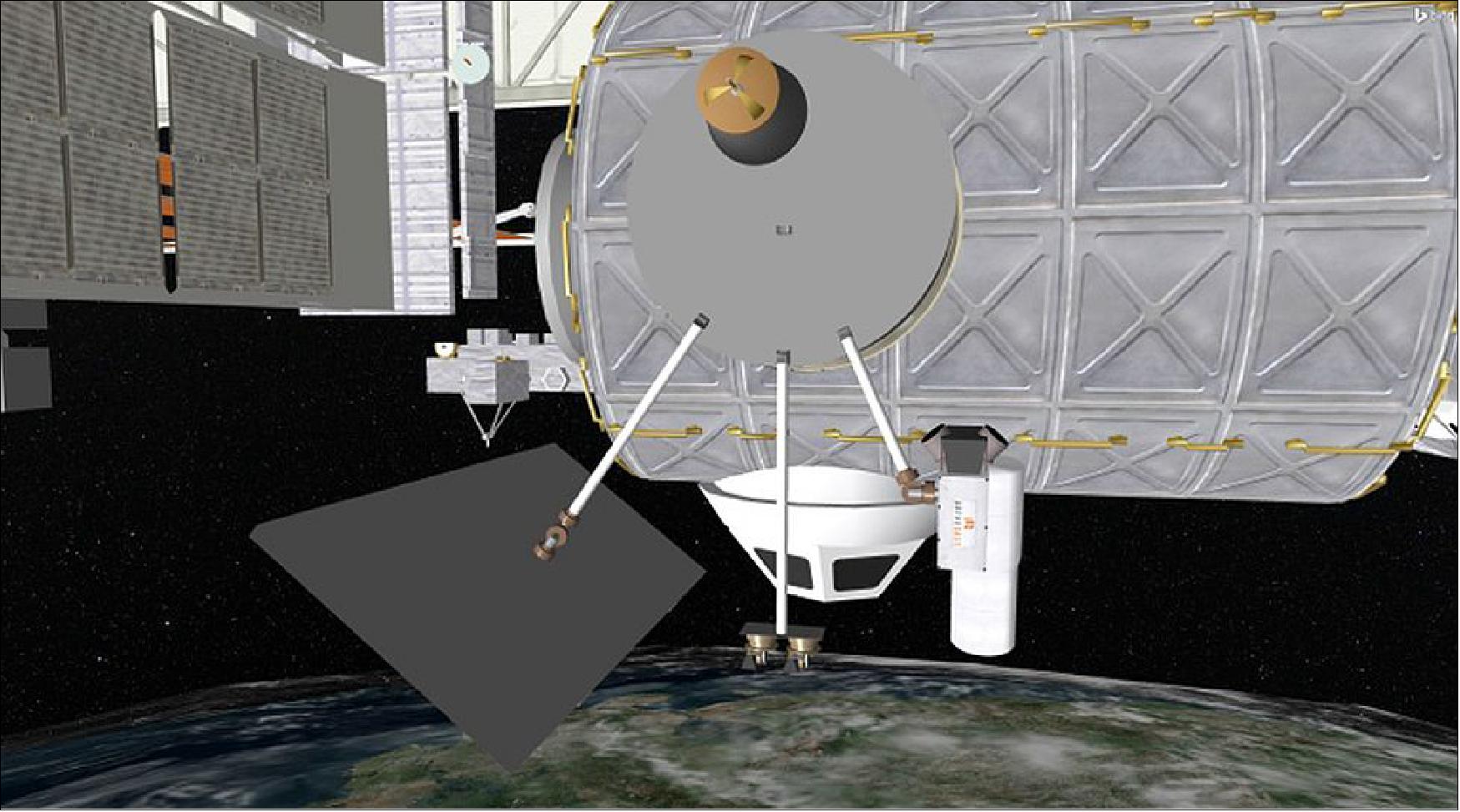
In partnership with NanoRacks LLC, UrtheCast has recently secured an agreement to install a dual-mode optical camera and a dual-band SAR on the NASA Segment of the ISS. Both sensors are mounted onto a custom module being jointly built by UrtheCast and NanoRacks, called the LUNA (Lightweight UrtheCast NanoRacks Alcove), which is attached to the aft CBM hatch on the Tranquility module (node 3 of the ISS).
Each instrument is deployed from the LUNA module on a dedicated boom which has its own three-axis gimbal mechanism, providing control in the roll, pitch and yaw directions, allowing the sensors to be operated independently, either dwelling on a target or covering a larger area for up to 90 seconds as the ISS passes overhead. It is possible to operate both instruments in tandem or individually, and to point both sensors at the same target area or at different target areas.
The LUNA module also has its own multi-Tbit on-board data storage and wideband X-band downlink. The downlink system comprises two independent high gain antennas on individual 2-axis gimbals that use left and right circular polarizations, providing a combined data rate of 1 Gbit/s. This is augmented with access to NASA’s ISS communications system that uses the TDRSS (Tracking and Data Relay Satellite System), providing near-continuous uplink and downlink communication capabilities.
Launch
A launch of the second-generation payload inside the Dragon capsule is planned for Q4 2017 on a SpaceX Falcon-9 v.1.1 vehicle.
Orbit: Near-circular orbit of the ISS, altitude of ~400 km, inclination = 51.6º, 16 revolutions/day.
Instruments
DOC (Dual-mode Optical Camera)
The DOC instrument can be operated either in pushbroom or video mode.
• The pushbroom sensor uses a 64-stage TDI (Time Delay Integration) architecture, digitized to 14 bits. This configuration yields a nominal 12 km swath (at nadir from 400 km altitude) and is comprised of a panchromatic channel providing imagery of 0.5 m resolution and six multispectral channels providing imagery of ~1 m resolution in the spectral bands: blue, green, yellow, red, red-edge and NIR (Near Infrared).
• The video sensor uses a 20 Mpixel CMOS detector that yields a nominal 3.5 km x 2.7 km footprint (at nadir from 400 km altitude) at up to 30 FPS, digitized to 12 bit. This detector uses a Bayer filter that provides three spectral channels (red, blue and green) providing imagery of ~0.5 m resolution.
• MetCam (Meteorological Camera) is augmenting the DOC instrument, providing additional spectral channels, albeit at a lower resolution, designed to measure the impact of the atmospheric contribution on the imagery and enable its correction during on-ground image processing. The data from the MetCam is not included in the distributed product though.
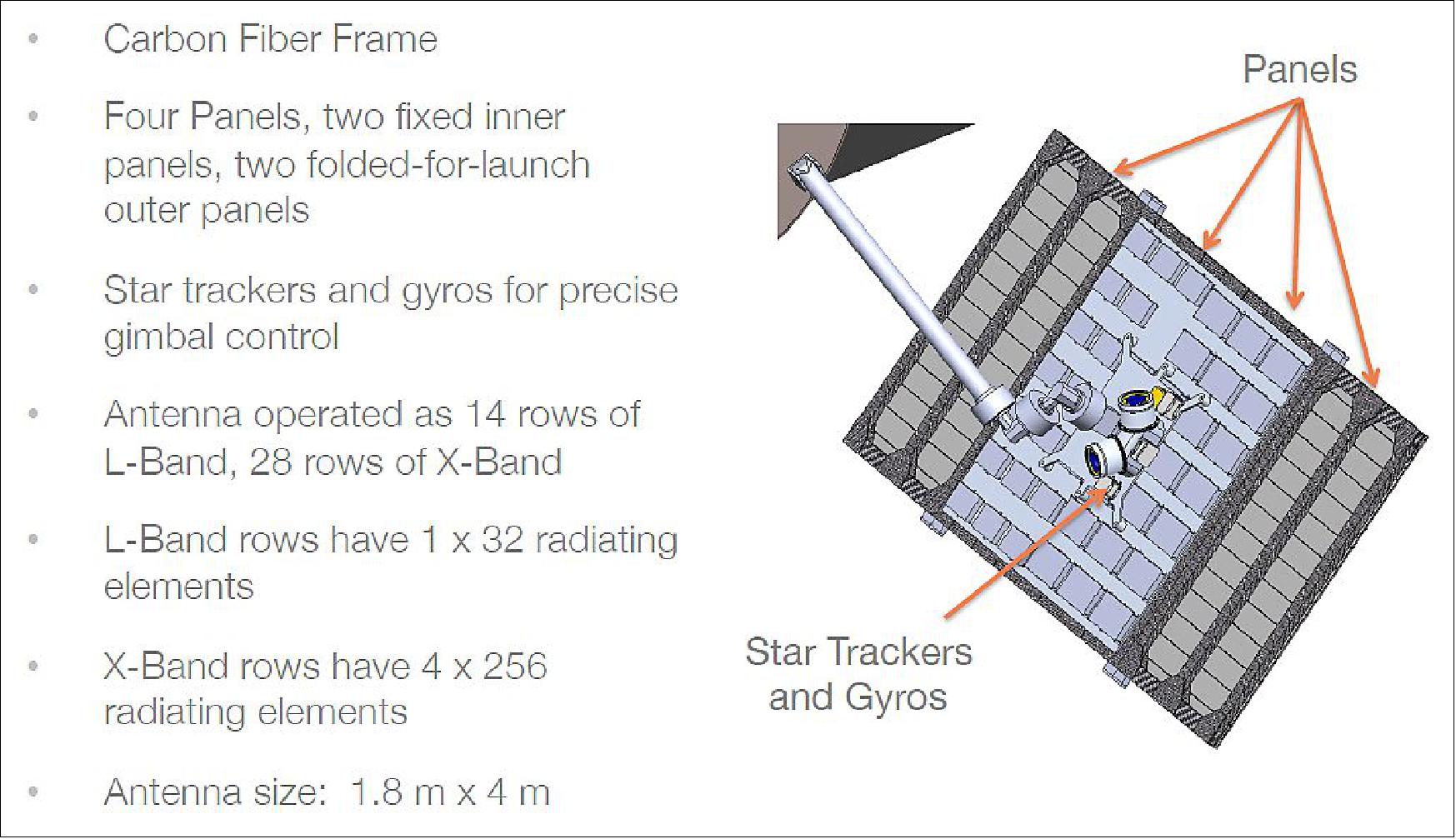
DB-SAR [Dual-band SAR (Synthetic Aperture Radar)]
The DB-SAR instrument can be operated in one of three modes: SpotLight, StripMap and ScanSAR.
- The SpotLight mode is able to acquire 1 m resolution (X-band) and 5 m resolution (L-band) imagery with a nominal footprint size of 5 km x 5 km.
- The StripMap mode is able to acquire 2 m resolution (X-band) and 10 m resolution (L-band) imagery with a nominal swath width of 10 km.
- The ScanSAR mode is able to acquire 10 m resolution (X-band) and 30 m resolution (L-band) imagery with a nominal swath width of 25 km when both bands are operated together. When operating L-band alone, the ScanSAR mode is able to acquire 30 m resolution imagery with a swath width of up to 100 km.
The L-band SAR supports the full complement of polarization options, including single, dual, quad, linear-compact and circular compact polarization. The X-band SAR supports VV polarization only. The SAR data can also be used to generate interferometric products.
Ground Segment
The existing UrtheCast Ground Segment and Web Platform will be upgraded to support the new sensors and the standard product types. In addition, a new suite of product types and services are envisioned that leverage the information available from the Second-Generation Sensors.
Products and Services
• Standard products: The Second-Generation System will generate an industry standard set of RPC (Rapid Positioning Capability) model and OM (Ortho Model) products and videos. These products will include the imagery (all optical sensor spectral channels and all SAR sensor polarizations) and the associated meta data for both instruments.
• Fusion products: The SAR and Optical data are highly complementary in terms of the information that can be extracted from each source.
The polarization and dielectric measurement provided by the SAR data can support determination of material classification, wetness, structure, texture and roughness information about the scene that the optical data often cannot. For example, agriculture and forestry applications based on optical data need to include a correction for soil moisture. And the SAR data can also assist in differentiating plant and tree types based on their polarization information. The SAR interferometric products can also be used to measure minute variations in the Earth’s surface.
The spectral measurement provided by optical data can support determination of signature classification information about the scene that SAR data often cannot. For example, the spectral signatures of different types of man-made objects, vegetation and geologic features are all well characterized in optical data, and less so in SAR data.
The addition of a time-series of images acquired by the video sensor over the arc of acquisition geometries yields an even deeper understanding of the scene due to the 3D surface model and motion vector information that it provides.
Consequently, the fusion of optical imagery, SAR imagery and interferometric information, 3D surface model and motion vector products yields a suite of products where there is significantly more information that can be extracted from any individual data source alone. This concept is well appreciated and it is worth noting that since 2006, the IGARSS (IEEE Geoscience and Remote Sensing Society) has sponsored multiple Data Fusion Contests, several of which (2009/2010 and 2012) involved both optical and SAR imagery.
With co-incident optical and SAR imagery, 3D surface model and motion vector information, the accuracy and range of possible applications becomes even more interesting because it eliminates a variety of unaccountable sources of error, typical of most fusion products resulting from the misregistration due to weather conditions, solar illuminations, temporal scene changes, viewing geometries, etc.
For example, in forestry biomass estimation, the X-band SAR sensor is used to locate the tops of the trees and the L-band SAR sensor is used to locate the bottom of the tree, thus yielding an accurate stand height. The pushbroom sensor is used to perform spectral classification to determine tree species and stand density. The video sensor is used to construct a 3D surface model of the scene and correct for any errors in the intermediate results. The data is then fused, in conjunction with the appropriate forestry models, in order to estimate the biomass.
The processing of high-resolution SAR data will benefit greatly from being fused with accurate 3D surface models and motion vector information, thus yielding accurately focused imagery. SAR data has been traditionally processed assuming a smooth Earth or a coarse DEM, and therefore tends to be somewhat out of focus and suffer from layover and shadow artefacts. Since SAR data relies on the Doppler phase history; objects that are moving are therefore mis-located.
The cyclic nature of the solar illumination variations from the ISS orbit will allow construction of shadow-free 3D image models of cities by fusing both optical and SAR data acquired over several orbits, giving both color and structural information for all surfaces.
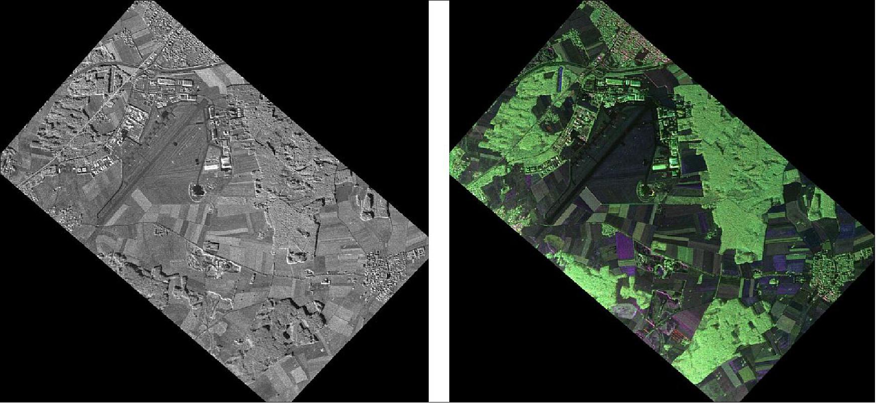
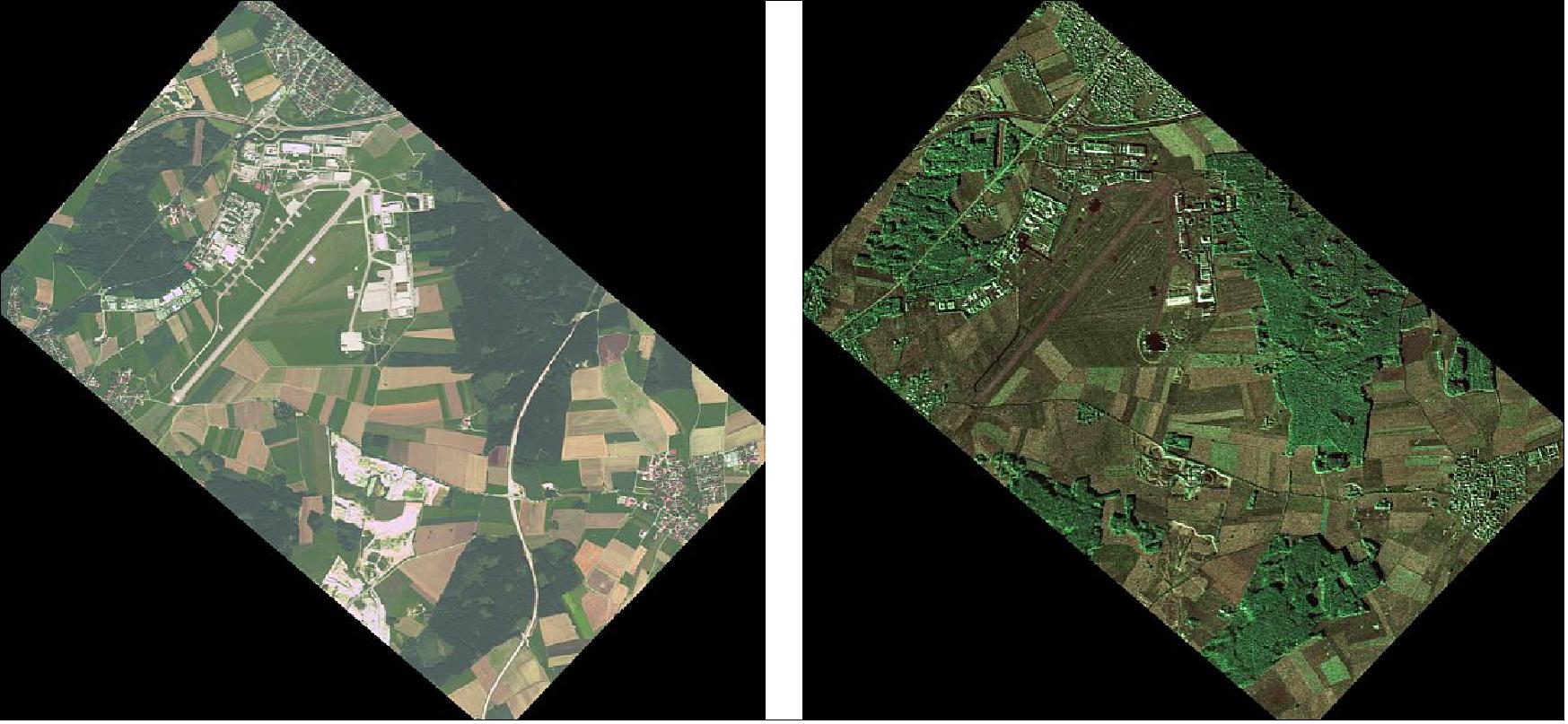
The images of Figures 19 and 20 illustrate a simple example of multi-sensor data fusion, combining X-band SAR, L-band SAR and multispectral optical imagery, resulting in a very content-rich information product.
Applications and Services: The standard and fusion products will feed into applications and services such as data analytics, site monitoring and wide-area reconnaissance.
The UrtheCast second-generation system will serve as a platform on for advancing the Research and Development of a host of new applications and services. The combination of on-board processing capability, flexible and highly-configurable optical and SAR sensor acquisition modes, and near-continuous communications will be used to support experiments involving novel acquisition geometries and imagery exploitation, and reducing latency in the delivery of actionable information to end users.
The key benefits of the UrtheCast second-generation system are significant improvements to monitoring, change detection, situational awareness and activity characterization capabilities as compared to traditional spaceborne remote sensing systems.
The advantages of SAR sensors are well known, providing reliable image acquisition at any time of day or night, and any weather conditions. It is therefore possible to guarantee, as a minimum, a SAR image in case the optical image is either cloudy or not adequately illuminated by the sun. Another advantage of SAR is that it provides texture and roughness information that characterizes the scene content.
The advantages of optical sensors are equally well known, where the spectral information provides an easy way to interpret and classify the imagery.
With a rich set of imagery and meta data acquired over a longer dwell time, accurate 3D model reconstruction and motion vector analysis of the scene is possible. Furthermore, this information is useful in generating accurate and higher-value products.
References
2) “Everything is about to change — UrtheCast is launching the world's first ever high definition, streaming video platform of planet Earth,”UrtheCast, August 2013, URL: http://www.snl.com/interactive/lookandfeel/4388192/UrtheCast_Investor_Deck%20August%2020.pdf
3) Stephen Clark, “UrtheCast says it will be largest commercial ISS user,” Spaceflight Now, Oct. 3, 2014, URL: http://spaceflightnow.com/news/n1410/03urthecast/#.VVGv1pM_P_V
4) “World's first 'live' video feed of Earth from space,” STFC RAL Space, URL: http://www.stfc.ac.uk/RALSpace/
Areas+of+expertise/Technology/High+resolution+optical+imaging/36120.aspx
5) “RALCam-3,” STFC RAL Space, URL: http://www.stfc.ac.uk/RALSpace/
Areas+of+expertise/Technology/High+resolution+optical+imaging/Systems+Engineering/19016.aspx
6) “UrtheCast - Cameras for the ISS,” STFC RAL Space, URL: https://www.stfc.ac.uk/RALSpace/
Areas+of+expertise/Technology/High+resolution+optical+imaging/44089.aspx
7) “Space cameras to monitor forests,” BBC News, June 17, 2008, URL: http://news.bbc.co.uk/2/hi/sci/tech/7459472.stm
8) “The CEOS Database,” 2014, URL: http://database.eohandbook.com
/database/missionsummary.aspx?missionID=602
9) “UrtheCast - Cameras for the ISS,” STFC RAL Space, URL: https://www.stfc.ac.uk/RALSpace/
Areas+of+expertise/Technology/High+resolution+optical+imaging/44089.aspx
10) “STFC Built Cameras to offer the first ever near-live images of Earth,” STFC, URL: http://www.stfc.ac.uk/2948.aspx
11) Jonathan Amos, “UK-built cameras heading for space station,” BBC News, Nov. 20, 2013, URL: http://www.bbc.com/news/science-environment-25005726
12) “Epic spacewalk will put us in the front row for near live video of the Earth,” STFC RAL Space, Jan. 28, 2014, URL: http://www.stfc.ac.uk/RALSpace/44214.aspx
13) “Spotlight: UrtheCast Inc.,” Space News, May 29, 2012, URL: http://www.spacenews.com/article/spotlight-urthecast-inc#.UK3BmJGQk9Y
14) Stephen Clark, “Second spacewalk planned to install UrtheCast cameras,” Spaceflight Now, Jan. 16, 2014, URL: http://www.spaceflightnow.com/station/exp38/140116urthecast/#.Ut_WovswdGc
15) Nicos V. Spyropoulos, “UrtheCast System of Systems for Dynamic EO monitoring,” IAEA (International Atomic Energy Agency) of the United Nations, Vienna, Austria, October 20-24, 2014, URL: http://www.iaea.org/safeguards/symposium/2014/home/eproceedings/sg2014-slides/000411.pdf
16) Jason Rainbow, ”Optical imagery-focused EarthDaily Analytics emerges from UrtheCast,” SpaceNews, 21 April 2021, URL: https://spacenews.com/
optical-imagery-focused-earthdaily-analytics-emerges-from-urthecast/
17) ”Urthecast Bankruptcy Surprises No One,” SAR Journal, 24 October 2020, URL: http://syntheticapertureradar.com/urthecast-bankruptcy-surprises-no-one/
18) Theras Wood, ”Spot the Waterskier in this Iris Video GIF,” UrtheCast, Jan. 15, 2015, URL: https://blog.urthecast.com/updates/iris-spots-waterskier/
19) Octavia Payne, Karla Renschler, ”UrtheCast offers a high-resolution view of the world’s forests on Global Forest Watch,” GFW, Jan. 11, 2016, URL: http://blog.globalforestwatch.org/2016/
01/urthecast-offers-a-high-resolution-view-into-the-worlds-forests-on-global-forest-watch/
20) Theras Wood, ”Monitor the World’s Forests with UrtheCast Imagery on Global Forest Watch,” UrtheCast, Jan. 12, 2016, URL: https://blog.urthecast.com/updates
/urthecast-imagery-now-available-global-forest-watch-platform/
21) Peter B. de Selding, ”UrtheCast Shelves New ISS Camera To Focus on Satellite Constellation ,” Space News, Nov. 12, 2015, URL: http://spacenews.com/
urthecast-shelves-new-iss-camera-to-focus-on-satellite-constellation/
22) Theras Wood, ”Vancouver Harbor Brims with Life in HD Video,” UrtheCast, Sept. 29, 2015, URL: https://blog.urthecast.com/updates/vancouver-harbour-brims-with-life-in-hd-video/
23) Theras Wood, ”UrtheCast’s Acquisition of Deimos Named ‘Strategic Transaction of the Year’,” UrtheCast, Sept. 18, 2015, URL: https://blog.urthecast.com/updates
/urthecasts-acquisition-of-deimos-named-strategic-transaction-of-the-year/
24) Theras Wood, “UrtheCast welcomes two Earth Observation satellites to its mission,” UrtheCast, July 15, 2015, URL: http://blog.urthecast.com/updates/urthecasts-new-satellites-provide-big-data/
25) “UrtheCast Closes Acquisition of Earth Observation Satellites and Business Operations from Elecnor,” UrtheCast Press Release, July 15, 2015, URL: http://investors.urthecast.com
/file.aspx?IID=4388192&FID=30295993
26) “UrtheCast To Acquire the Deimos Imaging Earth Observation Business from Elecnor, S.A.,” UrtheCast Release, June 22, 2015, URL: http://tinyurl.com/pvr6kqq
27) Theras Wood, “London, Boston, Barcelona: The World’s First Full-Color HD Videos Of Earth From Space,” UrtheCast, June 17, 2015, URL: http://blog.urthecast.com/updates
/london-boston-barcelona-worlds-first-full-color-hd-videos-earth-space/
28) Theras Wood, “UrtheCast And Pepsi® Partner To Create An Epic Film Adventure For The New Pepsi® Challenge™,” UrtheCast, May 12, 2015, URL: http://blog.urthecast.com/updates/
urthecast-and-pepsi-partner-to-create-an-epic-film-adventure-for-the-new-pepsi-challenge/
29) Theras Wood, “UrtheCast Teams With NASA To Stream Live High-Definition Earth Video,” UrtheCast, April 23, 2015, URL: http://blog.urthecast.com/updates/
urthecast-teams-with-nasa-to-stream-live-high-definition-earth-video/
30) Theras Wood, “UrtheCast Signs Contract For $65 Million To Provide Value-Added Services and Data,” UrtheCast, Nov. 24, 2014, URL: http://blog.urthecast.com/updates/
urthecast-signs-contract-65-million-provide-value-added-services-data/
31) Theras Wood, “UrtheCast Acquires Access To TDRSS, Greatly Increases Data Downlink Capacity and Speed,” Oct. 1, 2014, URL: http://blog.urthecast.com/updates/
urthecast-acquires-access-tdrss-greatly-increases-data-downlink-capacity-speed/
32) Theras Wood, “UrtheCast & NanoRacks To Install Earth Observation Cameras On NASA Segment Of Space Station,” UrtheCast, July 16, 2014, URL: http://blog.urthecast.com/updates/
urthecast-nanoracks-to-install-earth-observation-cameras-on-nasa-segment-of-space-station/
33) “UrtheCast & NanoRacks To Install Earth Observation Cameras On NASA Segment Of Space Station,” NanoRacks, July 16, 2014, URL: http://nanoracks.com/earth-observation-cameras/
34) Theras Wood, “UrtheCast Announces Commercial Availability Of Earth Imagery & Provides An Update On Its High-Resolution Camera,” UrtheCast, July 16, 2014, URL: http://tinyurl.com/kf4olyh
35) http://blog.urthecast.com/updates/urthecast-heads-to-geoint-2013/
36) Theras Wood, “UrtheCast’s First Release Of Earth Imagery From Space,” UrtheCast, April 3, 2014, URL: http://blog.urthecast.com/updates/urthecasts-first-release-of-earth-imagery-from-space/
37) http://www.urthecast.com/firstlight
38) “UrtheCast And International Space Station Operations Continue Without Pause,” CNW, April 3, 2014, URL: http://www.newswire.ca/en/
story/1333661/urthecast-and-international-space-station-operations-continue-without-pause
39) “UrtheCast Cameras Successfully Pass Initial Functional Tests,” Feb. 18, 2014, URL: http://blog.urthecast.com/updates/urthecast-cameras-successfully-pass-initial-functional-tests/
40) “UrtheCast Cameras Successfully Installed On International Space Station,” Jan. 28, 2014, URL: http://blog.urthecast.com/updates/urthecast-cameras-successfully-installed-on-international-space-station/
41) “UrtheCast Camera Installation Update,” Dec. 30, 2013, URL: http://blog.urthecast.com/updates/urthecast-camera-installation-update/
42) Elizabeth Howell, “Six-Hour Spacewalk Yields Two Installed Cameras, But Data Problems, NASA Says,” Universe Today, Jan. 27, 2014, URL: http://www.universetoday.com/108679
/six-hour-spacewalk-yields-two-cameras-but-data-problems-nasa-says/
43) Keith Beckett, “UrtheCast Second-Generation Earth Observation Sensors,” Proceedings of ISRSE (36th International Symposium on Remote Sensing of Environment), Berlin, Germany, May 11-15, 2015, Editor(s): G. Schreier, P. E. Skrovseth, and H. Staudenrausch, “ URL: http://www.int-arch-photogramm-remote-sens-spatial-inf-sci.net/XL-7-W3/1069/2015/isprsarchives-XL-7-W3-1069-2015.pdf
The information compiled and edited in this article was provided by Herbert J. Kramer from his documentation of: ”Observation of the Earth and Its Environment: Survey of Missions and Sensors” (Springer Verlag) as well as many other sources after the publication of the 4th edition in 2002. - Comments and corrections to this article are always welcome for further updates (eoportal@symbios.space).
First Generation Launch Mission Status Second Generation Instruments
Ground Segment References Back to top