Kalpana-1
EO
Atmosphere
Ocean
Cloud type, amount and cloud top temperature
Quick facts
Overview
| Mission type | EO |
| Agency | ISRO |
| Mission status | Mission complete |
| Launch date | 12 Sep 2002 |
| End of life date | 01 Feb 2018 |
| Measurement domain | Atmosphere, Ocean, Land |
| Measurement category | Cloud type, amount and cloud top temperature, Liquid water and precipitation rate, Radiation budget, Surface temperature (land), Surface temperature (ocean), Atmospheric Winds |
| Measurement detailed | Precipitation intensity at the surface (liquid or solid), Cloud type, Upward long-wave irradiance at TOA, Land surface temperature, Sea surface temperature, Wind profile (horizontal) |
| Instruments | DRT-S&R, VHRR |
| Instrument type | Imaging multi-spectral radiometers (vis/IR), Communications |
| CEOS EO Handbook | See Kalpana-1 summary |
Kalpana-1 / MetSat-1 (Meteorological Satellite-1)
Spacecraft Launch Mission Status Sensor Complement References
MetSat-1 is ISRO's first dedicated GEO weather satellite project built by ISRO. So far, meteorological services had been combined with telecommunication and television services in the INSAT series. MetSat-1 is a precursor to the future INSAT system that will have separate satellites for meteorology and telecommunication & broadcasting services.
Note: In a commemorative ceremony on Feb. 6, 2003, the MetSat-1 satellite of ISRO was renamed to Kalpana-1 by Indian Prime Minister Atal Bihari Vajpayee. This is to honor Kalpana Chawla, born in Karnal (1961), India, who died as a NASA astronaut on Feb. 1, 2003 over the southern USA when Space Shuttle Columbia (flight STS-107, Jan. 16 - Feb. 1, 2003) and her crew perished during reentry. 1) 2)
The exclusive meteorological payload has its advantages in such arguments as: 3) 4)
• The scarce resource of orbital slot and frequency spectrum are best exploited, if the missions (communication vs meteorological) are made exclusive
• The performance of the meteorological payload gets somewhat constrained in the environment of high power transponders
• There is an urgent need to realize an in-orbit replacement for this all-too-important national service of meteorology. MetSat-1 has to fill the void caused by two important meteorological payloads, namely VHRR/2 on INSAT-2E which failed already in 1999.
On Nov. 4, 2000, ISRO was forced to retire INSAT-2B, after it ran out of station-keeping fuel (in July 2000, INSAT-2B completed its design life of seven years of operation). This action stopped of course also the VHRR instrument on INSAT-2B, used for operational meteorology. MetSat-1 is considered a cost-effective solution to serve exclusively in GEO for meteorological payloads and services.
The policy on future ISRO GEO satellites continues to separate the meteorological and communication payloads on a case-by-case basis. The next exclusive meteorological satellite of ISRO is INSAT-3D which will carry a meteorological imager, a meteorological sounder as well as SASAR and DRT payloads. Since the configuration of INSAT-3 series of satellites is already decided, the multipurpose INSAT-3A carries a VHRR and a CCD camera besides SASAR and DRT (DCS) payloads.
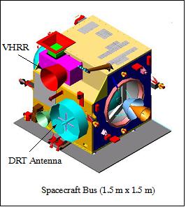
Spacecraft
The MetSat-1 spacecraft was developed by ISAC (ISRO Satellite Center), Bangalore. MetSat has been designed using a new spacecraft bus (I-1000 bus) employing lightweight structural elements like CFRP (Carbon Fibre Reinforced Plastic). A central structural thrust cylinder provides mounting interfaces propellant tanks, pressurant tank, equipment panels, payload, solar array assembly, and with the launch vehicle.
Structural brackets are provided to mount momentum wheels, reaction wheel, RCS (Reaction Control System) thrusters, earth sensors, sun sensors, LAM (Liquid Apogee Motor), and propulsion components.
MetSat-1 is three-axis stabilized (momentum biased control subsystem). However, unlike its INSAT predecessors, the MetSat-1 spacecraft does not feature a sail/boom design. The attitude is sensed by suite of sensors (gyros, Earth sensors, digital sun sensor, coarse analog sun sensors, and solar panel sun sensor). Magnetic torquers serve as actuators to unload the momentum of the wheels. In addition, active thrusters are used (one 440N LAM for orbit raising maneuvers and eight 22 N thrusters for orbit and attitude control).
The propulsion system employed is a unified bi-propellant with mono-methyl hydrazine (MMH) as fuel and mixed oxides of nitrogen (MON3) as oxidizer. The S/C employs passive thermal control system by utilizing multi-layer insulation blankets, optical solar reflectors, heat sinks, paints, thermal grease, thermal shields etc. A bank of 112 heaters spread over the satellite maintain the temperature of individual subsystems. 5) 6) 7)
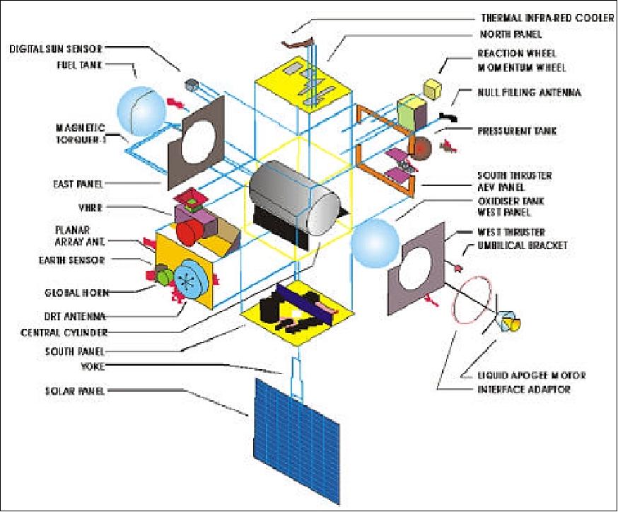
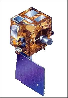
EPS (Electrical Power Subsystem): Electrical power of 550 W is generated by a single panel solar array of 2.15 m x 1.85 m using GaAS solar cells. The solar panel features a drive mechanism to point it into the sun. A single NiCd battery (18 Ah capacity) provides power for eclipse phases. The SADA (Solar Array Driver Assembly) slip rings and drive mechanism are modified to meet the power transfer and drive requirements, it is mass-optimized
The spacecraft has a launch mass of 1055 kg including 560 kg of propellant (495 kg S/C dry mass). MetSat-1 has a design life of 7 years with an operational goal of 10 years.
Launch: The MetSat-1 spacecraft was launched into GTO on Sept. 12, 2002 with ISRO's PSLV -C4 (Polar Satellite Launch Vehicle) from the "Satish Dhawan Space Center, SHAR," India (initial GTO of ~ 220 km x 34,500 km with 17.67º inclination).
All post-launch spacecraft operations and support activities are conducted by MCF (Master Control Facility) at Hassan located in south-west India. The instrument data are acquired by the Meteorological Utilization Center in New Delhi.
Orbit: Geostationary orbit, altitude ~35,786 km, spacecraft position at 74.1º E longitude.
RF communication: The downlink frequency for the payload data is in C-band (4503.05 MHz) at data rates of up to 526.5 kbit/s. The EIRP is 18 dBW. A new element called planar array antenna is used to transmit VHRR/2 and Data Relay Transponder (DRT) data.
Mission Status
• The Kalpana-1 satellite and its payload are operational in January 2017, providing its services more than 14 years on orbit. The DCS (Data Collection System) is currently not being used due to excessive orbit inclination (3.8º). 8)
- ISRO operates currently the following meteorological missions in GEO: Kalpana-1 (launch Sept. 12, 2002), INSAT-3A (launch April 9, 2003), INSAT-3D (launch July 25, 2013) and INSAT-3DR (launch Sept. 8, 2016).
• December 2015: According to the APRSAF-22 (Asia-Pacific Regional Space Agency Forum) country report of ISRO, the Kalpana-1/MetSat-1 spacecraft and its payload are operational. 9)
• The Kalpana-1/MetSat-1 spacecraft and its payload are operating nominally in 2015 (in its 13th year on orbit). 10)
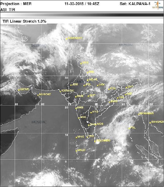
- In CGMS-42-IMD-WP-01, IMD (India Meteorological Department) informed CGMS (Coordination Group for Meteorological Satellites) that currently three Indian meteorological satellites are in operation: Kalpana-1, INSAT-3A and INSAT-3D. With the help of these three satellites, IMD is able to monitor several phenomena like, cyclones, western disturbances, thunderstorms, etc., and provide early warnings to the affected areas. 11)
- Kalpana/MetSat-1 images and products are available through the dedicated web sites www.imd.gov.in and www.mosdac.gov.in on a near real-time basis.
• The Kalpana-1/MetSat-1 spacecraft and its payload are operating nominally in 2013. 12)
• Kalpana-1/MetSat-1 and its payload are operating nominally in 2012, in its 10th year on orbit. TheVHRR/2 instrument is returning Earth disc images once every half hour. 13)
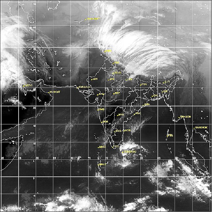
• Kalpana-1/MetSat-1 is operating nominally in 2011 (in its 9th year on-orbit). 14)
• Kalpana-1/MetSat-1 is operating nominally in 2010. 15) 16)
• On February 5, 2003, MetSat-1 was renamed to Kalpana-1 by the then Indian Prime Minister Atal Bihari Vajpayee in memory of Kalpana Chawla - an Indian born American astronaut who perished in the Space Shuttle Columbia disaster.
• In-orbit performance evaluation of MetSat-1 and its payload started on Sept. 24, 2002.
• First imagery was received from VHRR/2 on Sept. 23, 2002; this coincided with the spacecraft reaching its GEO position.
Sensor Complement
VHRR/2 (Very High Resolution Radiometer)
VHRR/2 is a modified version of the VHRR heritage imagers flown on INSAT-2A, -2B, and -2E. The VHRR/2 observes in VIS, water vapor and TIR bands providing a spatial resolution of 2 km in VIS band and 8 km for the rest. VHRR/2 was developed by SAC (Satellite Application Center), Ahmedabad, India. The instrument operates in three scanning modes:
• Full frame mode (20º North-South x 20º East-West), minimum in about 33 minutes covering the entire Earth disk
• Normal frame mode (14º N-S x 20º E-W), minimum in about 23 minutes
• Sector frame mode in which the sector can be positioned anywhere in steps of 0.5º in the N-S direction to cover 4.5º N-S x 20º E-W. This mode is particularly suited for rapid, repetitive coverage during severe weather conditions like a cyclone.
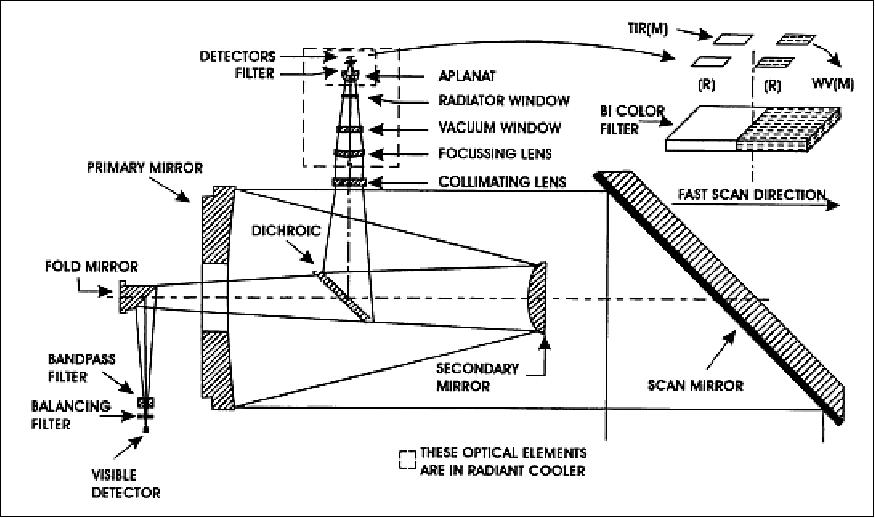
The nominal frame repetition rates are: 40, 30 and 20 minutes respectively. VHRR/2 is an optomechanical system (whiskbroom type imager). The incoming solar radiation is reflected onto a Ritchey-Chretien telescope of 20 cm aperture by a beryllium scan mirror mounted at 45º to the optical axis. The optical system includes a gold-film dichoric beam-splitter that transmits visible light energy and reflects WV/TIR energy, so that the radiation from the Earth is channelized to the visible and IR focal planes simultaneously.
The visible band detector configuration consists of two staggered arrays of four silicon photodiodes each; while two sets of mercury-cadmium telluride (MCT) detector elements operating nominally at 100-110 K sense the WV/thermal radiation. The scan mirror is mounted on a two-axis, gimballed scan mechanism system to generate a 2-D image by sweeping the detector instantaneous field of view (FOV) across the Earth's surface in east to west (fast scan) and north to south (slow scan).
Spectral band: VIS | 0.55 - 0.75 µm; Integrated out-of-band response <3% |
Spatial resolution VIS | 56 µrad (or 2 km x 2 km) |
Radiometric performance: SNR | > 6 for VIS at 2.5% albedo |
Dynamic range of TIR/MWIR channels | 4-340 K |
Misregistration between VIS and IR | < 56 µrad |
Modulation Transfer Function (MTF) | > 21% for IR and TIR; >23% for VIS channel |
Imaging mode | Coverage | Repeatability |
Full scan | 20º N-S and 20º E-W | 33 min |
Normal scan | 14º N-S and 20º E-W | 23 min |
Sector scan | 4.5º N-S and 20º E-W | 23 (3 times) |
Channel | No of detectors | MTF (Modulation Transfer Function) | Dynamic range | Noise performance |
VIS | 4 +4 redundant | > 0.23 approx. | 0-100% albedo | 6 : 1 min at 2.5% albedo |
Water Vapor (WV) | 1 + 1 redundant | > 0.21 approx. | 4-340 K | 0.25 K at 300 K |
TIR | 1 + 1 redundant | > 0.21 approx. | 4-320 K | 0.5 K at 300 K |
DRT (Data Relay Transponder)
The DRT (Data Relay Transponder) is part of a DCS (Data Collection System) of ISRO. The objective is to collect data from unattended meteorological platforms in the ground segment. DRT receives receives signals from unattended weather data collection platforms and retransmits them to the central station. The data from these payloads are being used for comprehensive weather status and forecasting.
RF communication of DRT: Uplink frequency = 402.75 MHz; downlink frequency = 4506.05 MHz; bandwidth = ± 100 kHz; EIRP = 21 dBW (min).
Note: MetSat-1 does not carry SAS&R (Satellite Aided Search and Rescue) system. In the INSAT-2 series, the INSAT-2A and -2B satellites carried SAS&R transponders as well as DRTs (Data Relay Transponders). According to ISRO information, INSAT-3A (launch April 9, 2003) and INSAT-3D (to be launched subsequently), will carry SAS&R and DRT payloads.
References
1) "ISRO METSAT Satellite Series Named After Columbia Astronaut Kalpana Chawla," SpaceRef, Feb. 6, 2003, URL: http://www.spaceref.com/news/viewnews.html?id=732
2) "Kalpana-1 Geo-Stationary Satellites," ISRO, URL:
http://resource.itschool.gov.in/physics-web/isro/www.isro.org/satellites/kalpana-1.html
3) Information provided by S. Krishnamurthy of ISRO/HQ and by Killugudi S. Jayaraman of Bhopal, India
4) V. K. Kaila, A. S. Kirankumar, T. K. Sundaramurthy, S. Ramakrishnan, M. Y. S. Prasad, P. S. Desai, V. Jayaraman, B. Manikiam, "METSAT - a unique mission for weather and climate," Current Science, Vol. 83, No 9, Nov. 2002, pp.1081-1088, URL: http://www.currentscience.ac.in/Downloads/article_id_083_09_1081_1088_0.pdf
5) V. K. Kaila, V. R. Katti, "METSAT - A Dedicated Meteorological Mission of ISRO," 4th IAA Symposium on Small Satellites for Earth Observation, April 7-11, 2003, Berlin, Germany, URL: http://www.dlr.de/iaa.symp/Portaldata/49/Resources/dokumente/archiv4/IAA-B4-0205P.pdf
6) S. K. Srivastav, S. Prasad, R. C. .Bhatia, D. Singh, V. R. Rao, "Current and Future Satellite Programs and Systems in India," The 2003 EUMETSAT Meteorological Satellite Conference, Weimar, Germany, Sept. 29 - Oct. 3, 2003
7) http://www.isac.gov.in/earth-observation/html/kalpana.jsp
8) Satellite: Kalpana-1," WMO, January 4, 2017, URL: https://www.wmo-sat.info/oscar/satellites/view/210
9) P. G. Diwakar, "Indian Space Program Country Report," APRSAF-22 (Asia-Pacific Regional Space Agency Forum), Bali, Indonesia, December 1-4, 2015, URL: http://www.aprsaf.org
/annual_meetings/aprsaf22/pdf/program/plenary/D3_1150_India_ISRO-Country-Report.pdf
10) "CEOS EO Handbook-Agency Summary - ISRO," Updated for 2015, URL: http://database.eohandbook.com/database/agencysummary.aspx?agencyID=11
11) Report of the 42 nd Meeting of the Coordination Group for Meteorological Satellites (CGMS-42), Guangzhou, China, 19-23 May 2014, URL:
http://www.cgms-info.org/documents/CGMSMR42_00_FullReport.pdf
12) Vinay K Dadhwal, "25 Years of Indian Remote Sensiing Satelllliite ((IIRS)) Seriies," Proceedings of the 50th Session of Scientific & Technical Subcommittee of UNCOPUOS, Vienna, Austria, Feb. 11-22, 2013, URL: http://www.oosa.unvienna.org/pdf/pres/stsc2013/tech-44E.pdf
13) Information provided by A. S. Kiran Kumar of ISRO/SAC, Ahmedabad, India
14) CEOS EO Handbook," Oct. 2010, URL: http://database.eohandbook.com/database/agencysummary.aspx?agencyID=11
15) Pradip K. Pal, "Plan of Indian Satellites to understand the science of tropical weather & climate," GEWEX SSG Meeting, New Delhi, India, Jan. 25-28, 2010, URL:
http://www.gewex.org/ssg-22/presentations/PKPal-ISRO-Indian%20Satellites.pdf
16) "Earth Observation System for Climate Change: ISRO's Initiatives and Perspectives," Country Report India, APRSAF 17 (Asia Pacific Regional Space Agency Forum), , Melbourne, Australia, Nov. 23-26, 2010, URL: http://www.aprsaf.org/data/aprsaf17_data/D3-1045_P_S_Roy.pdf
The information compiled and edited in this article was provided by Herbert J. Kramer from his documentation of: "Observation of the Earth and Its Environment: Survey of Missions and Sensors" (Springer Verlag) as well as many other sources after the publication of the 4th edition in 2002. - Comments and corrections to this article are always welcome for further updates (eoportal@symbios.space).
Spacecraft Launch Mission Status Sensor Complement References Back to top