Kanopus-V 1 (Kanopus-Vulkan N1)
EO
ROSKOSMOS
Mission complete
High resolution optical imagers
The Kanopus-Vulkan N1 (Kanopus-V 1) satellite was an Earth observation minisatellite mission of the Russian Space Agency (ROSKOSMOS) and the Federal Service for Hydrometeorology and Environmental Monitoring (ROSHYDROMET). The overall objective of the mission was to monitor Earth’s surface, the atmosphere, ionosphere, and magnetosphere to detect and study the probability of strong earthquake occurrence and other natural disasters.
Quick facts
Overview
| Mission type | EO |
| Agency | ROSKOSMOS |
| Mission status | Mission complete |
| Launch date | 22 Jul 2012 |
| End of life date | 01 Jul 2020 |
| Measurement domain | Land, Snow & Ice |
| Measurement category | Multi-purpose imagery (land), Vegetation, Albedo and reflectance, Sea ice cover, edge and thickness, Snow cover, edge and depth |
| Measurement detailed | Land surface imagery, Fire fractional cover, Earth surface albedo, Land cover, Sea-ice cover, Snow cover |
| Instruments | PSS, MSS |
| Instrument type | High resolution optical imagers |
| CEOS EO Handbook | See Kanopus-V 1 (Kanopus-Vulkan N1) summary |

Summary
Mission Capabilities
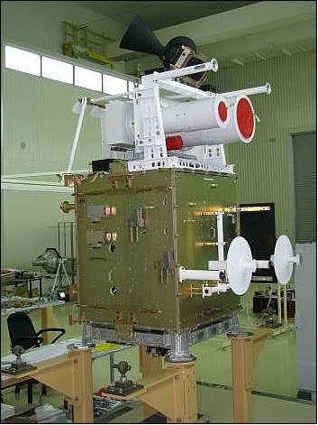
Kanopus-V 1 was the first mission in a series of Kanopus satellites, and carried three prototype instruments to carry out Earth observation measurements. The Panchromatic Imaging System (PSS) and Multispectral Imaging System (MSS) were both high resolution optical imagers with PSS carrying out imagery for environmental monitoring, agriculture and forestry while MSS provided imagery of land and coastal surfaces and ice cover. The Multispectral Scanner Unit - 200 (MSU-200) was also a high resolution optical imager with the objective to provide imagery of land and sea surface and ice cover.
Performance Specifications
The three instruments on board Kanopus-V 1 all measured within the Visible (VIS) and Near Infrared (NIR) spectral ranges. PSS was a panchromatic imager which measured in one spectral band from 0.52 μm to 0.84 μm while MSS was a multispectral imager and measured in four spectral bands between 0.54 μm and 0.86 μm. MSU-200 supported MSS and measured in one panchromatic channel over the spectral range of the MSS instrument. PSS had the best spectral resolution at 2.1 m and a swath width of 23 km, while MSS had a spectral resolution of 12 m and swath width of 20 km. MSU-200 had the largest swath width of 250 km and could measure with a spectral resolution of 25 m.
Kanopus-V 1 was in a Sun-synchronous orbit with an orbital period of 94.7 minutes, an orbital inclination of 97.4° and at an altitude of 510 km.
Space and Hardware Components
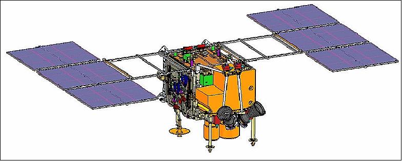
The spacecraft was built collaboratively by the Federal State Unitary Enterprise (FSUE) NPP VNIIEM of Moscow and Surrey Satellite Technology Ltd (SSTL) on behalf of ROSKOSMOS. The satellite had a launch mass of 450 kg and had a cross-track direction body-pointing capability to allow for event monitoring. The satellite had 24 GB of onboard storage and Radio Frequency (RF) communications were made with the satellite in the X-band at a data rate of 300 Mbit/s.
Kanopus-V 1 was launched on July 22, 2012 on a Soyuz FG vehicle from the Baikonur Cosmodrome, Kazakhstan. After 8 years of successful service, the mission came to an end in July 2020.
Kanopus-V 1 (Kanopus-Vulkan N1, Environmental Satellite)
Spacecraft Launch Mission Status Sensor Complement References
Kanopus-V (also spelling of Canopus-V N1) is an Earth observation minisatellite mission of the Russian Space Agency, Roskosmos and ROSHYDROMET/Planeta. The overall objective is to monitor Earth's surface, the atmosphere, ionosphere, and magnetosphere to detect and study the probability of strong earthquake occurrence. The requirements call for:
• Monitoring of man-made and natural emergencies including natural disasters and hydrometeorological phenomena
• Mapping
• Detection of forest fire seats, large environmental pollutant emissions
• Recording of abnormal phenomena to study the possibility of earthquake prediction
• Monitoring of agriculture, water and coastal resources
• Land use
• Highly operational observation of specified regions of the Earth's surface.
Spacecraft
The spacecraft contract of Roskosmos was awarded to FSUE (Federal State Unitary Enterprise) NPP VNIIEM of Moscow. VNIIEM in turn chose to work with SSTL (Surrey Satellite Technology Ltd.) because of the company's established reputation and considerable experience in building small satellites. A contract to this effect was signed in March 2007. 1) 2)
Under the subcontract, SSTL is supplying three suites of satellite avionics and software plus system design support, power management and batteries, on board computers and data handling capabilities for satellite subsystems and satellite operations. SSTL will also support spacecraft assembly and integration activities in Russia. 3)
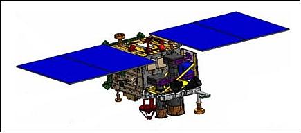
Kanopus-V provides a body-pointing capability in the cross-track direction to permit event monitoring. The spacecraft has a launch mass of ~ 450 kg and a design life of 5 years.
RF communications: X-band (8.2 GHz) downlink of payload data, data rate of 300 Mbit/s, onboard data storage of 24 GB.
Launch
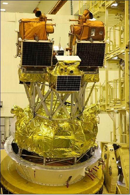
The Kanopus-V-N 1 spacecraft was launched on July 22, 2012 on a Soyuz FG/Fregat vehicle from the Baikonur Cosmodrome, Kazakhstan. The launch provider was Starsem. 4) 5) 6)
Note: The last launch date for Kanopus-V was scheduled for September 2011. However, the Soyuz launch vehicle experienced a failure on August 24, 2011, carrying a Progress M-12M capsule filled with supplies for the ISS (International Space Station). This event resulted in a failure investigation and in a follow-up delay of all planned Soyuz launches.
Secondary payloads on this flight are:
• Belka-2 (Belarusian space apparatus-2), also referred to as BKA, a minisatellite of Belarus (NASRB) with a mass of ~ 400 kg
• TET-1 (Technologie Erprobungs Träger-1), a technology probe of DLR, Germany with a mass of 120 kg
• Zond-PP, a microsatellite of IRE (Institute of Radiotechnology and Electronics), Moscow, Russia for technology demonstrations.
• exactView-1 (formerly ADS-1B) a communication microsatellite with a mass of 100 kg (AIS applications) of exactEarth (COM DEV), Canada. SSTL acted for exactEarth as launch agent in collaboration with Commercial Space technologies (CST) in Russia.
Orbit: Sun-synchronous near-circular orbit on ascending node, altitude = 510 km, inclination = 97.8º, period = 98 minutes, repeat cycle = 17 days.
Kanopus-V, Belka-2 and TET-1 were released into an orbit of ~ 510 km. Afterwards, Fregat had to maneuver to a higher ~800 km orbit to deploy Zond-PP and the exactView-1 payloads. All satellites were successfully deployed and Fregat made a deorbit maneuver.
Mission Status
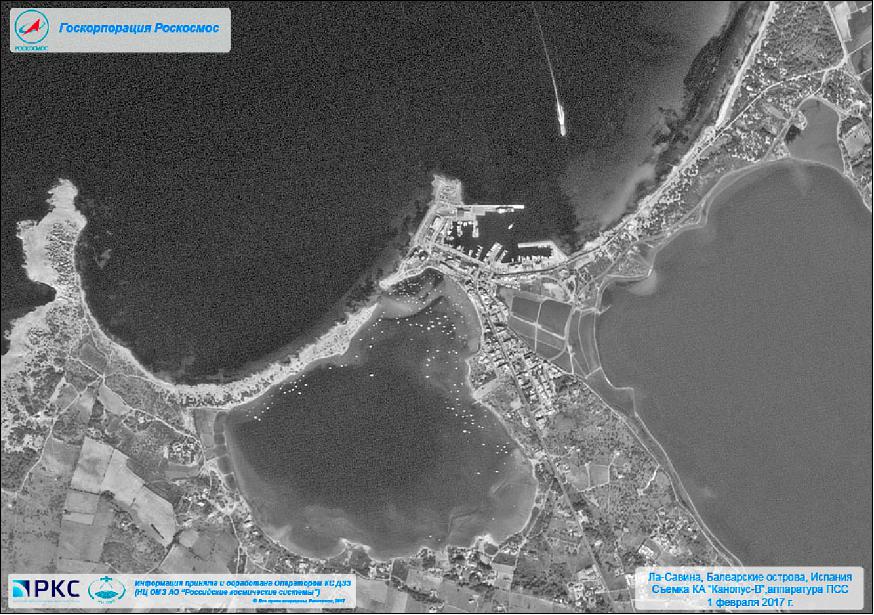
• The Kanopus-V1 spacecraft and its payload are operational in early 2017 (5th year on orbit). 7)
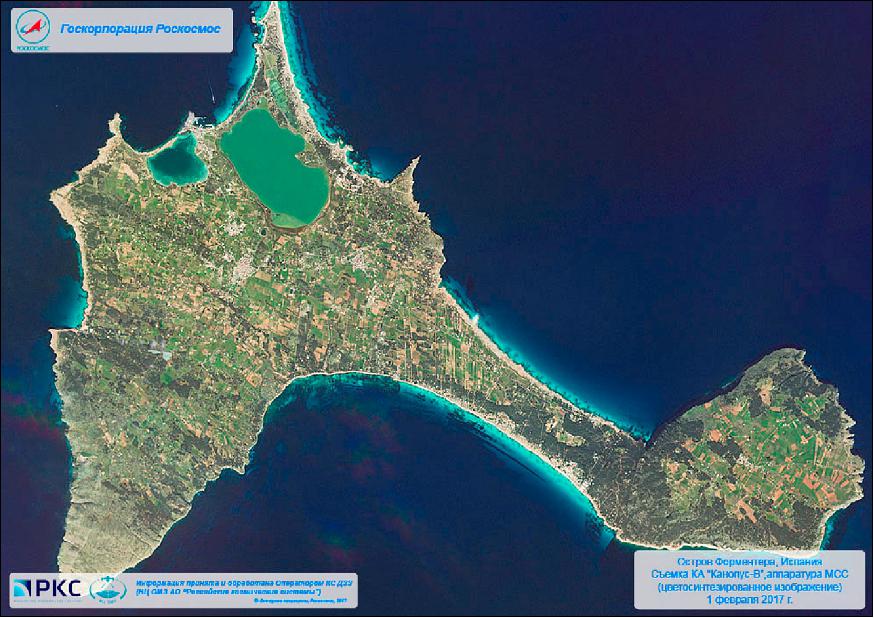
Legend to Figure 5: The main island of Formentera is 19 km long and is located about 6 km south of Ibiza in the Mediterranean Sea.
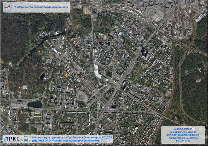
• The Kanopus-V1 spacecraft and its payload are operational in May 2015. 8)
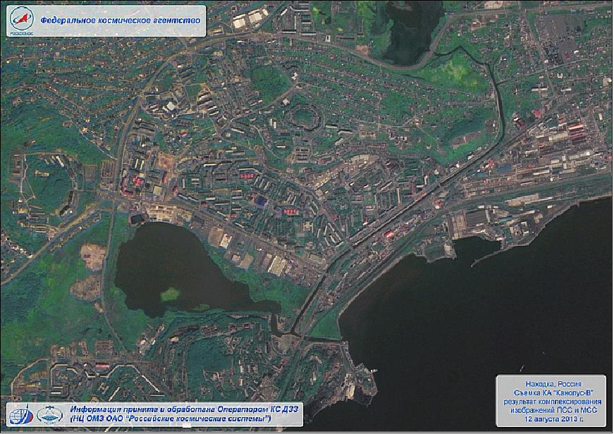
• The Kanopus-V1 spacecraft and its payload are operational in August 2013. 9)
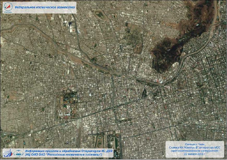
• In January 2013, the Kanopus-V No 1 imaging spacecraft had successfully entered the operational phase of its mission following its launch in July 2012. This was announced on Jan. 29. 2013 by Roskosmos, the Russian Space Agency. 10) 11)
• In August 2012, Kanopus-V has taken its first imagery of the Earth's surface. The satellite is still operating in "trial mode," but the quality of the imagery is "reassuring." 12)
Sensor Complement
PSS (Panchromatic Imaging System)
PSS is a prototype instrument with the objective to provide panchromatic imagery for environmental monitoring, agriculture and forestry.
The imager provides high resolution imagery of 2.5 m on a swath of 20 km. The spectral range is 0.5 - 0.8 µm.
MSS (Multispectral Imaging System)
MSS is a prototype instrument with the objective is to provide multispectral imagery of land and coastal surfaces and ice cover.
The instrument provides a spatial resolution of 12 m on a swath of 20 km. Four spectral bands are provided: 0.5 - 0.6 µm; 0.6 - 0.7 µm; 0.7 - 0.8 µm; 0.8 - 0.9 µm.
Parameters | PSS (Panchromatic Imaging System) | MSS(Multispectral Imaging System) |
Spectral bands | 1 | 4 |
Panchromatic | 0.52-0.85 µm |
|
MS (Multispectral) bands |
| 0.54-0.60, 0.63-0.69, 0.69-0.72, 0.75-0.86 µm |
Focal length | 1797.5 mm | 359.5 mm |
Relative hole | 1:10.3 | 1:5.6 |
Transmittance | 0.7 | 0.6-0.8 |
Matrix size, pixels | 1920 x 985 | 1920 x 985 |
Swath width (nadir) | 23.3 km | 20.1 km |
GSD (Ground Sample Distance) | 2.1 m | 10.5 m |
Data quantization | 12 bit | 12 bit |
MSU-200 (Multispectral Scanner Unit)
MSU-200 is a prototype instrument with the objective to provide imagery of land and sea surfaces and ice cover. The spatial resolution is 25 m on a swath of 250 km. The spectral coverage is 0.54 - 0.86 µm.
References
1) "Russia Places Order With SSTL For Satellite Platform Equipment," Space Daily, March 28, 2007, URL:
http://www.spacedaily.com/reports
/Russia_Places_Order_With_SSTL_For_Satellite_Platform_Equipment_999.html
2) Vladimir Gecha, Elena Kanunnikova, Igor Pugach, "VNIIEM (All-Russian Scientific Research Institute of Electromechanics)," URL: http://www.ciemat.es/sweb/Spain-ISTC-STCU/22abril/vniiem1.pdf
3) "SSTL Delivers On Russian KANOPUS Missions," March 10, 2009, Space Daily, URL: http://www.spacemart.com/reports/SSTL_Delivers_On_Russian_KANOPUS_Missions_999.html
4) "Soyuz FG Launch Updates - July 2012," Spaceflight 101, July 22, 2012, URL: http://www.spaceflight101.com/soyuz-fg-launch-updates-kanopus-belka-exactview-zond-tet.html
5) "SSTL announces the successful launch of exactView-1," SSTL, July 22, 2012, URL: https://www.sstl.co.uk/media-hub/latest-news/2012/sstl-announces-the-successful-launch-of-exactview-1
6) CEOS Handbook, URL:
http://database.eohandbook.com/database/missionsummary.aspx?missionID=610
7) "Images from Kanopus-V1 Spacecraft," NTs OMZ (Research Center for Earth Operative Monitoring), February 2, 2017, URL: [web source no longer available]
8) Images from Kanopus-V1 Spacecraft (May 2015)," .NTs OMZ (Research Center for Earth Operative Monitoring), May 13, 2015, URL: [web source no longer available]
9) Russian Space Systems (RSS). URL: [web source no longer available]
10) Anatoly Zak, "Kanopus-V declared operational," Jan. 29, 2013, URL: http://www.russianspaceweb.com/kanopus.html
11) "Images from KANOPUS-V1 Spacecraft (21.01.2013 - 27.01.2013)," URL: [web source no longer available]
12) "Remote Sensing Satellite Sends First Earth Imagery," Space Daily, Sept. 3, 2012, URL: http://www.spacedaily.com/reports/Remote_Sensing_Satellite_Sends_First_Earth_Imagery_999.html
13) V. V. Nekrasov a, E. Makusheva, "Satellite Canopus-V Image Processing Technology Development for Cartography Purposes Based on Prelaunch Simulation," Proceedings of the 22nd Congress of ISPRS (International Society of Photogrammetry and Remote Sensing), Melbourne, Australia, Aug. 25 - Sept. 1, 2012, International Archives of the Photogrammetry, Remote Sensing and Spatial Information Sciences, Volume XXXIX-B4, 2012, URL:http://tinyurl.com/m6c2kog
The information compiled and edited in this article was provided by Herbert J. Kramer from his documentation of: "Observation of the Earth and Its Environment: Survey of Missions and Sensors" (Springer Verlag) as well as many other sources after the publication of the 4th edition in 2002. - Comments and corrections to this article are always welcome for further updates (eoportal@symbios.space).
Spacecraft Launch Mission Status Sensor Complement References Back to top