LAGEOS (Laser Geodynamics Satellite-I) / LAGEOS-II
EO
NASA
Gravity and Magnetic Fields
Gravity, Magnetic and Geodynamic measurements
LAGEOS-I and II (Laser Geodynamics Satellite) are unique, passive, research satellites designed to act as permanent reference points that can be used to track the movement of the Earth through space to a high degree of accuracy. The satellites are designed to orbit the Earth for millions of years to come.
Quick facts
Overview
| Mission type | EO |
| Agency | NASA, ASI |
| Mission status | Operational (nominal) |
| Launch date | 04 May 1976 |
| Measurement domain | Gravity and Magnetic Fields |
| Measurement category | Gravity, Magnetic and Geodynamic measurements |
| Measurement detailed | Gravity field, Crustal Motion, Gravity gradients, Crustal plates positioning |
| Instruments | LRA (LAGEOS) |
| Instrument type | Precision orbit |
| CEOS EO Handbook | See LAGEOS (Laser Geodynamics Satellite-I) / LAGEOS-II summary |
Summary
Mission Capabilities
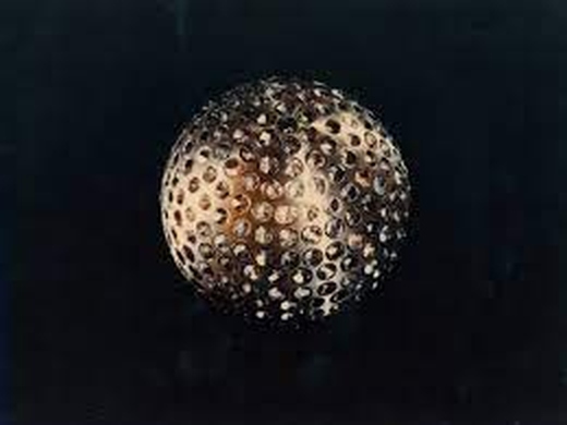
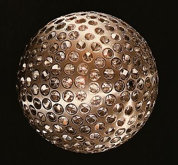
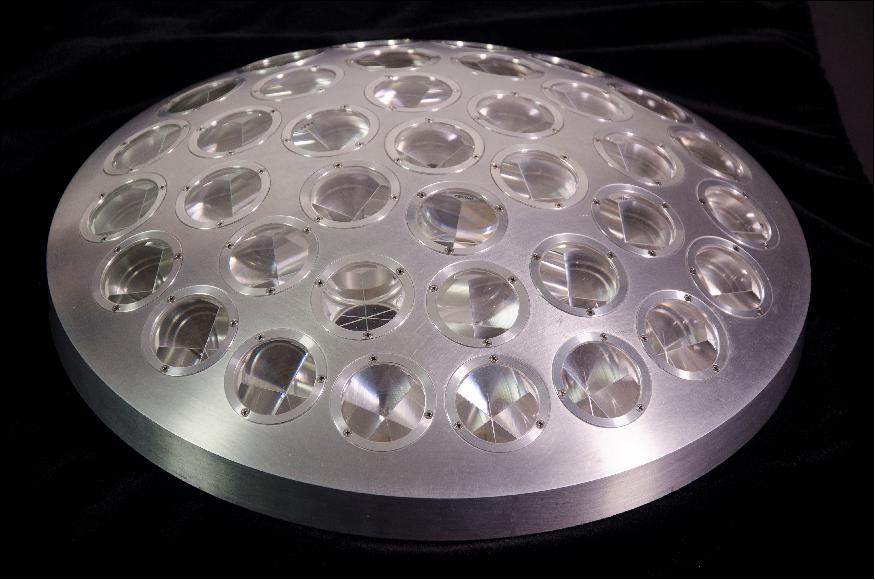
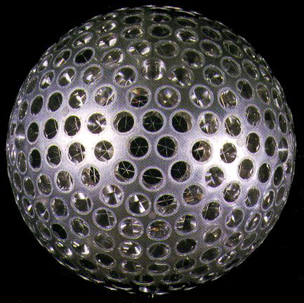
Each spacecraft consists of an aluminium sphere that measures 60 cm in diameter surrounding a brass core. LAGEOS-I weighs 411 kg, whilst LAGEOS-II weighs 405 kg. Embedded within the outer surface of each spacecraft are 426 prisms. Each prism reflects laser beams back to their source, regardless of the angle of origination. Combining the travel times of lasers to and from LAGEOS, fired from ground stations in different parts of the world, allows precise location of the satellites in three-dimensional space. This can be measured accurately to within a few millimetres. 422 of the 426 prisms are composed of fused silica glass, while the remaining four are made of germanium.
Performance Specifications
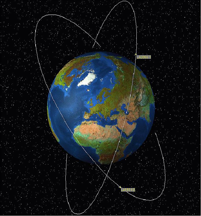
LAGEOS-I and II follow near-circular orbits at altitudes of approximately 5860 km and 5620 km, respectively. The inclination of orbit for LAGEOS-I is prograde at 109.84o, while that of LAGEOS-II is retrograde at 52.64o. The orbital period is 225 minutes for LAGEOS-I and 223 minutes for LAGEOS-II.
Space and Hardware Components
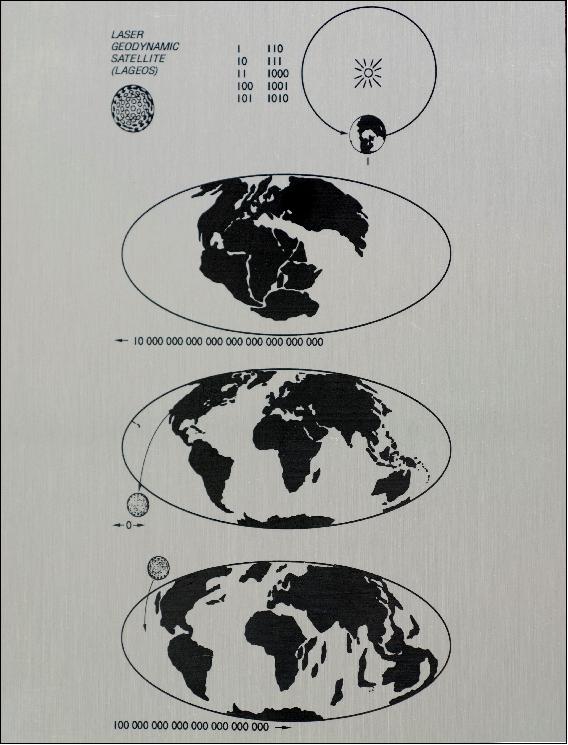
Being passive research satellites designed for a long mission life, there are no electronics or moving parts in either of the LAGEOS satellites. As they are expected to orbit for an estimated 8.4 million years into the future, LAGEOS carries a plaque displaying three maps of the Earth at different Epochs. The first shows the continents of the planet 268 million years ago, the second shows the continents at the time of launch, and the third shows the predicted arrangement of the continents 8.4 million years into the future, when LAGEOS is predicted to fall to Earth.
LAGEOS-I (Laser Geodynamics Satellite-I) / LAGEOS-II
Overview Spacecraft Launch Mission Status LAGEOS-II References
LAGEOS-I is a passive research satellite of NASA - the orbit of the spacecraft (and its slight perturbations) represents the geodynamic measurements. LAGEOS-I is the first NASA satellite dedicated wholly to laser ranging. LAGEOS was designed to act as a permanent reference point so that the Earth's progress could be tracked relative to the satellite (in contrast to the traditional system of tracking satellites relative to the Earth). One of LAGEOS' functions is to aid in the understanding of the Earth's crustal motions. The USGS (United States Geological Survey) as well as many institutions around the world are tracking the LAGEOS orbit to study the dynamics of the solid Earth, to analyze (deduce) continental drift (plate tectonics, crustal deformations), the Earth's gravitational field, and the "wobble" in the Earth's axis of rotation. 1) 2)
Spacecraft
The LAGEOS spacecraft is an aluminium sphere with a brass core, built for NASA/GSFC by Bendix Aerospace Systems. The satellite has a diameter of 60 cm and a mass of 411 kg - a very massive satellite (cannonball) for its small size, with a minimal cross-section. The materials were chosen to reduce the effects of the Earth's magnetic field on the satellite's orbit. Its 426 prisms, called `corner-cube reflectors,' are embedded in the satellites' surface. Of these, 422 are made of fused silica glass while the remaining 4 are made of germanium. As a passive satellite, there are no onboard sensors or electronics, there is no attitude control - and of course no communication with the spacecraft.
The three-dimensional prisms reflect laser beams back to the source, regardless of the angle from which they come. Pulsed laser beams transmitted from Earth ground stations are returned by the reflectors on LAGEOS; the travel times are precisely measured, permitting ground stations in different parts of the world to measure their separations (to better than 1 cm in thousands of kilometres) to determine the distance between themselves and the satellite.
Launch
The launch of LAGEOS-I took place on May 4, 1976, on a Delta-2 launch vehicle from VAFB (Vandenberg Air Force Base), CA.
Orbit: Near-circular orbit, altitude = 5858 km x 5958 km (eccentricity of 0.0045), inclination = 109.84º, period = 225 min. The orbit is of the type MEO (Mean Earth Orbit), and is considered to be very stable. The spherical shape (symmetry) and orbit parameters have been chosen with the purpose of minimizing the effects of disturbing forces. The high-inclination orbit was chosen to permit the tracking of many ground stations around the world. 3) 4)
The first four years until 1980 were devoted to determining LAGEOS' precise orbit and to building up a global network of 14 Earth stations, i.e. SLR (Satellite Laser Ranging) stations. By accurately measuring the time for a laser pulse to travel to the satellite and return, the position of the laser system could be determined to be about 10 cm. Under NASA's Crustal Dynamics Project (started in 1979), 56 investigators from 12 countries were making repeated measurements between their locations and LAGEOS.
Since the LAGEOS-I orbit is known to have extremely high accuracy, the location of a laser ranging station on the surface of the Earth can be determined to a precision of less than 1 cm (by measuring the time for a laser pulse to travel from the laser ranging station to the satellite and return).
Note: The technique of laser ranging to a near-Earth satellite was initiated by NASA in Oct. 1964 with the launch of the Beacon-B satellite (also referred to as the Explorer-22 mission).
Applications
In the past 30 years, the Satellite Laser Ranging (SLR) technique has evolved and improved to a large extent, currently achieving a ranging precision down to a few millimetres. Moreover, the growth in the size of the international network of SLR stations and the rapidly growing constellation of geodetic target satellites make the SLR a well-established technique for solid Earth studies and for the related Earth subsystem sciences. The long SLR observation history has become a very important source of data for global and local change detection and monitoring in many different fields.
Following is a list of some applications: 5) 6)
• SLR is a proven geodetic technique with significant potential for important contributions to scientific studies of the Earth/atmosphere/oceans system
• SLR is the most accurate technique currently available to determine the geocentric position of an Earth satellite, allowing for the precise calibration of radar altimeters and separation of long-term instrumentation drift from secular changes in ocean topography.
• SLR's ability to measure the temporal variations in the Earth's gravity field and to monitor the motion of the station network with respect to the geocentre, together with the capability to monitor vertical motion in an absolute system, makes it unique for modelling and evaluating long-term climate change by:
- Providing a reference system for a post-glacial rebound, sea level and ice volume change
- Determining the temporal mass redistribution of the solid Earth, ocean, and atmosphere system
- Monitoring the response of the atmosphere to seasonal variations in solar heating.
• SLR provides a unique capability for verification of the predictions of the Theory of General Relativity. For instance: The Astro-Metrology Group at the University of Maryland at College Park has developed methods of measurement of satellite spin dynamics based on experimental measurements made by the group on the LAGEOS-I geodetic satellite using the Goddard Space Flight Center's 48" telescope. Recent interest in using these satellites to measure the Lense-Thirring effect (General Relativistic Effect) has defined the need for knowledge of the current dynamics of the satellite. 7) 8) 9)
• SLR stations form an important part of the international network of space geodetic observatories, which include VLBI, GPS, DORIS and PRARE systems
• On several critical missions, SLR has provided fail-safe redundancy when other radiometric tracking systems have failed
• The International Laser Ranging Service (ILRS) has been formed by the global SLR community to enhance geophysical and geodetic research activities.
Mission Status
• On May 4, 2016, the LAGEOS-I satellite of NASA was 40 years on orbit. It is the first NASA orbiter dedicated to the precision measurement technique called SLR (Satellite Laser Ranging). With it, scientists have measured the movement of Earth's tectonic plates, detected irregularities in the rotation of the planet, weighed it, and tracked small shifts in its centre of mass. 10)
- Small deviations in the satellite's orbit were used to develop early models of Earth's gravitational field. Further perturbations in the orbit helped explain how sunlight heating small objects can affect their orbits, including near-Earth asteroids.
- Built to last, the 411 kg satellite is passive, with no onboard sensors or electronics and no moving parts. Its brass core is covered by an aluminium shell that is dotted with 426 retroreflectors, making the satellite look like a giant golf ball. "LAGEOS is elegantly simple – a ball covered with reflecting prisms," said Stephen Merkowitz, manager of NASA's Space Geodesy Project at the agency's Goddard Space Flight Center in Greenbelt, Maryland. "But it set a new standard for laser ranging and has provided 40 years of continuity for these measurements."
- The precise SLR measurements also made it possible to detect small irregularities in Earth's rotation, caused by the movement of mass in the atmosphere and oceans, and polar motion – the migration of the planet's axis of rotation. Ranging to LAGEOS was good enough to reveal small perturbations in the satellite's orbit, which provided the basis for early gravity models of Earth. The satellite also was used to detect a rebounding of Earth's crust in regions where it had flattened slightly when ancient ice sheets covered the Hudson Bay area, Finland and Scandinavia.
- "Today, we see Earth as one system, with the planet's shape, rotation, atmosphere, gravitational field and the motions of the continents all connected. We take it for granted now, but LAGEOS helped us arrive at that view," said David E. Smith, who was the LAGEOS project scientist at Goddard and is now at the Massachusetts Institute of Technology in Cambridge.
- A nearly identical sister satellite, LAGEOS-II, was launched in 1992 as a joint venture of the Italian Space Agency (ASI) and NASA. This satellite travels in a complementary orbit, and together, the two enabled a wider range of studies. The data from this pair were used to confirm one prediction of Einstein's general theory of relativity: frame dragging. This is a tiny perturbation of an object's orbit around a massive rotating central body, called the gravitomagnetic or Lense–Thirring effect.
- LAGEOS also led to the discovery of other subtle effects. One was the seasonal Yarkovsky effect, a tiny braking force that occurs when sunlight heats one side of the spacecraft and the spacecraft later emits that heat. This drag is a variation of the original Yarkovsky effect, which takes place because of the rotation of the satellite about its axis. The seasonal version takes place over the course of its orbit around Earth.
- The seasonal Yarkovsky effect – along with other minuscule forces – lowers LAGEOS' orbit by about 1 millimetre each day. "These and related effects are of particular interest lately because they can redirect the orbits of small objects, such as near-Earth asteroids," said David Rubincam, a Goddard scientist involved in these studies.
- These days, LAGEOS is part of a constellation of satellites that help establish and maintain the terrestrial reference frame, which links together navigation systems across the globe and serves as a fundamental reference for the interplanetary navigation of spacecraft. The two LAGEOS satellites have the unique role of defining the origin, or centre point, of the terrestrial reference frame; this is based on Earth's centre of mass.
- Still going strong on its 40th anniversary, LAGEOS is expected to revolve around Earth for millions of years. With that in mind, the orbiter carries a plaque designed by Carl Sagan (Figure 3). Most of the plaque is devoted to three panels, each with a map of Earth at a different epoch. The top panel represents Earth 268 million years ago when the continents were joined as a single land mass. The middle panel shows the modern-day configuration of the continents. The last panel projects the configuration 8.4 million years in the future when the satellite was originally predicted to finally fall to Earth.
• 2014: The status of both spacecraft remains unchanged. They are being tracked by a global network of SLR sites. 11)
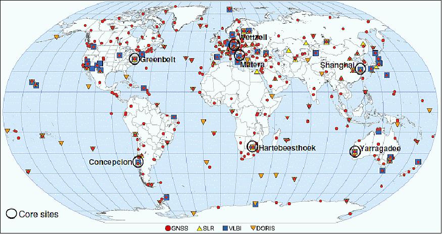
Legend to Figure 4: Over the years, 183 stations worldwide have ranged to LAGEOS, and dozens still do (Ref. 10).
• 2012: The passive spacecraft in MEO permit long-term tracking observations (over many decades - since the orbit of the satellite won't decay, the corner-cube reflectors may suffer a long-term decay from orbiting through the Van Allen radiation belts). The long-term availability of the passive satellites permits also tracking with new generations of SLR tracking systems (advanced technologies) in the ground segment for more precise ranging results and consequently orbit determination (model analysis, etc.).
Parameter / Mission | LAGEOS-1 | LAGEOS-2 |
Sponsor | USA | USA, Italy |
Expected life of mission | Many decades | Many decades |
Primary applications | Geodesy | Geodesy |
COSPAR ID of Spacecraft | 7603901 | 9207002 |
NORAD SSC Code | 8820 | 22195 |
Launch date | May 4, 1976 | October 22, 1992 |
RRA (RetroReflector Array) diameter | 60 cm | 60 cm |
RRA shape | Sphere | Sphere |
Reflectors | 426 corner cubes | 426 corner cubes |
Orbit | Circular | Circular |
Mass of the sphere | 406.965 kg | 405.38 kg |
LAGEOS-II
LAGEOS-II is a collaborative NASA-ASI geodesy mission [Aeritalia built the LAGEOS-II for ASI (Agenzia Spaziale Italiana) based on the same design as the NASA-provided LAGEOS-I], a follow-up of LAGEOS-I. LAGEOS-II has a mass of 405 kg, a diameter of 60 cm, and a total of 426 laser reflectors. LAGEOS-II is an identical S/C to LAGEOS-I. 12)
Launch of LAGEOS-II: The satellite was deployed from the Space Shuttle (Columbia, STS-52) launch from Cape Canaveral: on Oct. 22, 1992 (NASA). Italy developed and provided IRIS (Italian Research Interim Stage), a solid-fueled booster, which carried the satellite from the Shuttle's parking orbit into the required LAGEOS II orbit. 13)
Orbit: LAGEOS-II and LAGEOS-I are deployed in prograde (LAGEOS-II: 52.64º inclination) and retrograde (LAGEOS-I: 109.84º inclination) orbital planes, respectively. LAGEOS-II has a near-circular orbit with a perigee of 5616 km and an apogee of 5950 km, a period of 223 minutes.
The orbit of LAGEOS-II was selected to provide more coverage of seismically active areas, such as the Mediterranean Basin and California; it may help scientists understand irregularities noted in the motion of LAGEOS 1-I. The design of the 52.6º inclination orbit provides gravity and tidal sensitivity to improve on the advances from LAGEOS-I in a shorter time. The nodal precession period of LAGEOS-II is about one-half that of LAGEOS-I's three-year period. The related effect on the Earth's shadowing of the satellite gives rise to a signal in LAGEOS-II's acceleration pattern with a shorter period than LAGEOS-I. 14) 15)
Objectives: LAGEOS-II is an integral part of the Crustal Dynamics Project (CDP). Study of the Earth's crust in the Mediterranean region. Research in solid Earth geophysics [study of global and local tectonic processes, polar motion and Earth rotation, determination of Universal Time (UT1) and its variations, the recovery of Earth and ocean tidal parameters, and geopotential modelling].
Both LAGEOS satellites are tracked by a global network of fixed and transportable lasers from some 65 sites. The ILRS (International Laser Ranging Service) provides global satellite and lunar laser ranging data and their related products to support geodetic and geophysical research activities as well as IERS (International Earth Rotation Service) products important to the maintenance of an accurate ITRF (International Terrestrial Reference Frame). For the IERS activities, the ILRS focuses on the tracking collected on Lageos-I, Lageos-II and the moon. 16)
The data available to the investigators consist of both preprocessed and analyzed data (i.e. station positions, baselines, and Earth rotation parameters as a function of time). The data are being archived in the Crustal Dynamics Data Information System (CDDIS) at NASA/GSFC.
Frame Dragging
An international team of NASA and university researchers has dramatically improved the accuracy of the first direct evidence that the Earth drags space and time around itself as it rotates. The measurements used the latest gravity models obtained from the GRACE mission.
The research, reported in the journal Nature, is the most accurate direct measurement to date of the Lense-Thirring Effect - an effect of general relativity, which predicts a rotating mass will drag space around it. The Lense-Thirring Effect is also known as frame dragging (first predicted by two Austrian physicists Josef Lense (1890-1985) and Hans Thirring (1888-1976) in 1918), a consequence of Einstein's Theory of General Relativity, published in 1916.
Ignazio Ciufolini (University of Lecce, Italy) and Erricos C. Pavlis (Joint Center for Earth Systems Technology, Maryland) report to have made the first reasonably accurate measurement of frame dragging. They tracked the orbits of the LAGEOS-I and LAGEOS-II satellites for 11 years using the SLR technique. They state that Earth's rotation twists the fabric of space enough to displace the satellites by 1.9 m per year from where they would otherwise be, matching the amount predicted by general relativity with a measurement precision of about 10%. 17) 18) 19)
Note: A first direct measurement of the frame-dragging and geodetic effects and their magnitudes will be provided by GP-B (Gravity Probe-B), a NASA mission with a launch on Apr. 20, 2004. GP-B carries precision gyroscopes to measure the frame-dragging effect on its one-year mission.
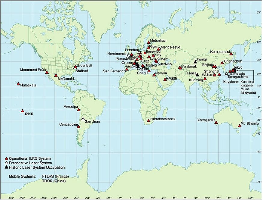
Legend to Figure 7: This is the map of international laser ranging network stations that collected the LAGEOS satellite data, which were used for this experiment. 20)
References
1) "LAGEOS 1, 2 LAser GEOdynimics Satellite," URL: http://space.jpl.nasa.gov/msl/QuickLooks/lageosQL.html
2) http://ilrs.gsfc.nasa.gov/satellite_missions/list_of_satellites/lag1_general.html
3) G. B. Afonso, F. Barlier, C. Berger, F. Mignard, J. J. Walch, "Reassessment of the charge and neutral drag of LAGEOS and its geophysical implications," Journal of Geophysical Research, Vol. 90, 1985, pp. 9381-9398.
4) G. B. Afonso, F. Barlier, M. Carpino, P. Farinella, F. Mignard, A. Milani, A. M. Nobili, "Orbital effects of LAGEOS seasons and eclipses," Annalae Geophysicae, Vol. 7, 1989, pp. 501-514
5) "International Laser Ranging Service," http://ilrs.gsfc.nasa.gov/docs/slrover.pdf
6) I. Ciufolini, P. Farinella, A. M. Nobili, D. Lucchesi, L. Anselmo, "Results of a joint ASI-NASA Study on the LAGEOS gravitomagnetic experiment and the nodal perturbations due to radiation pressure and particle drag effects," Il Nuovo Cimento B, Italian Physical Society, Volume 108, Number 2, February1993, pp. 151-162, DOI: 10.1007/BF02874407
7) D. G. Currie, K. E. Kissell, P. V. Avizonis, D. D. Wellnitz, "Measurement of the LAGEOS-I Spin Axis," URL: http://www.physics.umd.edu/rgroups/am/lageos.html
8) R. Wood, T. Otsubo, R. Sherwood, "Lageos 2 spin rate and orientation," http://cddis.nasa.gov/lw13/docs/papers/target_wood_1m.pdf
9) D. Kucharskia, G. Kirchnerb, S. Schillaka, E. Cristea, "Spin determination of LAGEOS-1 from kHz laser observations," Advances in Space Research, Vol. 39, Issue 10, 2007, pp. 1576-1581
10) Elizabeth Zubritsky, "Now 40, NASA's LAGEOS Set the Bar for Studies of Earth," NASA, May 4, 2016, URL: http://www.nasa.gov/feature/goddard/2016/now-40-nasas-lageos-set-the-bar-for-studies-of-earth
11) Guiseppe Bianco, "Thirty years of Space Geodesy at ASI," Proceedings of the 51st Session of Scientific & Technical Subcommittee of UNCOPUOS, Vienna, Austria, Feb. 11-22, 2014, URL: http://www.unoosa.org/pdf/pres/stsc2014/tech-48E.pdf
12) P. O. Minott, T. W. Zagwodzki, T. Varghese, M. Seldon, "Prelaunch Optical Characterization of the Laser Geodynamic Satellite (LAGEOS 2)", NASA Technical Paper 3400, 1993, URL: http://ilrs.gsfc.nasa.gov/docs/nasa_tp3400.pdf
13) "Columbia Successfully Lofts Italian LAGEOS Satellite," Space News, Oct. 26-Nov. 1, 1992, p. 13
14) P. Dunn, M. Torrence, R. Kolenkewicz, D. Smith, "Observations of Surface Forces on the LAGEOS Satellites," Geophysical Research Abstracts, Vol. 5, 07162, 2003
15) Giuseppe Bianco, "The Matera Laser Ranging Observatory (MLRO)," Frascati, Italy, March 21-23, 2006, URL: http://www.lnf.infn.it/conference/fps06/Bianco.PPT
16) Graham Appleby, Matthew Wilkinson, Vincenza Luceri, Philip Gibbs , Victoria Smith, "Attempts to separate apparent observational range bias from true geodetic signals," Proceedings of the 16th International Workshop on Laser Ranging, Poznan Poland, October 12-17, 2008, URL: http://cddis.gsfc.nasa.gov/lw16/docs/papers/net_1_Appleby_p.pdf
17) Ignazio, Cuifolini, E. Pavlis, "Measurement of Gravitomagnetism with Satellite Laser Ranging to LAGEOS, LAGEOS 2 and LARES Satellites," American Astronomical Society, IAU Symposium #261. Relativity in Fundamental Astronomy: Dynamics, Reference Frames, and Data Analysis, April 27 to May 1, 2009, Virginia Beach, VA, USA, #14.03; Bulletin of the American Astronomical Society, Vol. 41, p.890
18) D.M. Lucchesi, "The Lense–Thirring effect measurement and LAGEOS satellites orbit analysis with the new gravity field model from the CHAMP mission," Advances in Space Research, Volume 39, Issue 2, 2007, pp. 324-332
19) I. Ciufolini, E. C. Pavlis, "A confirmation of the general relativistic prediction of the Lense-Thirring effect," Nature, Vol. 431., Oct. 21, 2004, pp. 958-960, doi:10.1038/nature03007
20) Krishna Ramanujan, "As World Turns it Drags Time and Space," NASA, Oct. 21, 2004, URL: http://www.nasa.gov/vision/earth/lookingatearth/earth_drag.html
The information compiled and edited in this article was provided by Herbert J. Kramer from his documentation of: "Observation of the Earth and Its Environment: Survey of Missions and Sensors" (Springer Verlag) as well as many other sources after the publication of the 4th edition in 2002. - Comments and corrections to this article are always welcome for further updates (eoportal@symbios.space).
Overview Spacecraft Launch Mission Status LAGEOS-II References Back to top