Meteor-1/Meteor-2/Meteor-Priroda Series
EO
Atmosphere
Atmospheric Temperature Fields
ROSKOSMOS
Quick facts
Overview
| Mission type | EO |
| Agency | ROSKOSMOS, ROSHYDROMET |
| Mission status | Mission complete |
| Launch date | 01 Jan 1993 |
| End of life date | 28 Feb 1995 |
| Measurement domain | Atmosphere, Snow & Ice |
| Measurement category | Atmospheric Temperature Fields, Atmospheric Humidity Fields, Ozone, Sea ice cover, edge and thickness, Snow cover, edge and depth |
| Measurement detailed | Atmospheric specific humidity (column/profile), O3 Mole Fraction, Atmospheric temperature (column/profile), Sea-ice cover, Snow cover, Sea-ice thickness |
| Instruments | 174-K, MR-900B, RMK-2, Chaika, MR-2000, MR-900 |
| Instrument type | Imaging multi-spectral radiometers (vis/IR), Earth radiation budget radiometers, Other, Atmospheric temperature and humidity sounders |
| CEOS EO Handbook | See Meteor-1/Meteor-2/Meteor-Priroda Series summary |
Meteor-1/Meteor-2/Meteor-Priroda Series
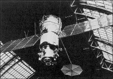
"Meteor" is the Soviet/Russian generic name for its Low-Earth-Orbiting (LEO) meteorological satellite family which started operation in 1969, designed and developed by VNIIEM (All-Russian Scientific and Research Institute of Electromechanics), Moscow. Sponsoring agency: ROSHYDROMET, the Russian Federal Service for Hydrometeorology and Environmental Monitoring. Prior to this series there was an experimental Cosmos series with the first orbiting meteorological satellite, "Cosmos-44," which was launched on August 25, 1964, and was followed by nine analogous Cosmos satellites until 1969, when the succeeding series was officially named Meteor-1.
Spacecraft | Launch Date | Launch Site, Launch Vehicle | Launch Mass |
Cosmos-44 | Aug. 25, 1964 | Baikonur, Vostok-2M | 4730 kg |
Cosmos-58 | Feb. 26, 1965 | ||
Cosmos-100 | Dec. 17, 1965 | ||
Cosmos-118 | May 11, 1966 | ||
Cosmos-122 | June 25, 1966 | ||
Cosmos-144 | Feb. 28, 1967 | Plesetsk, Vostok-2M | |
Cosmos-156 | April 27, 1967 | ||
Cosmos-184 | Oct. 25, 1967 | ||
Cosmos-206 | Mar. 14, 1968 | ||
Cosmos-226 | June 12, 1968 |
The designations of the series Meteor-1, -2, and -3 define different payload configurations, improved spacecraft platforms, and different orbits. The Meteor-3 series is presently the most advanced payload generation and the operational series. A total of 25 Meteor-1 satellites were launched from 1969 to 1977 (three to four launches per year). Note: Meteor-1-18 is also referred to as Meteor-Priroda-1; Meteor-1-25 is also named Meteor-Priroda-2. 1) 2)
Background: ROSHYDROMET is the national central agency providing relevant environmental and climate information to the public, various industrial organizations and decision-making bodies. Hydrometeorological services together with the provision of information on environmental pollution are based on the performance of the National Observing System for the State of the Environment and Climate (GSNP). GSNP operates data acquisition facilities (ground network of synoptic, hydrological and upper-air stations, weather radars, aircraft, rocket sounding stations, satellites and ocean ships), telecommunication and processing facilities, analysis and forecasts based on advanced atmospheric and hydrological models. 3)

The Meteor-1 series had an average spacecraft mass of 2200 kg. Application: meteorological sciences, operational meteorology.
Orbit: Non-sun-synchronous polar orbit, average altitude of 650 km for the first nine satellites and 900 km for the rest of the series, inclination = 81-82º.
Sensor Complement
TV (TV optical instrument) also referred to as MR-600A. Framing (vidicon technique). Spectral range: 0.4 - 0.8 µm; swath width = 1000 km; resolution = 1.25-3 km.
IR (TV Infrared instrument, Lastocha). Spectral range: 8 - 12 µm; swath width = 1000 km; resolution = 15 km.
AC (Radiation Budget Sensor). AC is a narrow-sector device which measures the sun's radiation fluxes, the thermal radiation of the Earth's surface, cloud cover and the atmosphere. Spectral range: 0.3 - 30 µm; swath width = 2500 km; resolution = 40 km x 50 km.
The Meteor series, somewhat similar to the NOAA-TIROS series, provides a daily weather review for more than two-thirds of the globe, observation of clouds, ice cover and atmospheric radiation; these satellites also permit the study of weather fronts and jet stream currents and monitor of clear-air turbulence (for warning intercontinental airliners, etc.).
Meteor-2 Series
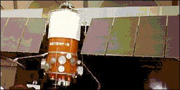
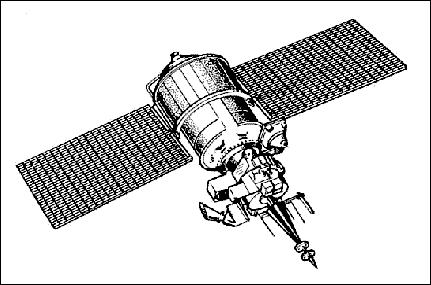
Soviet/Russian Earth observation satellite series in the field of meteorology. Sponsoring agency: ROSHYDROMET. The Meteor-2 series (developed and built by VNIIEM, chief designer: A. G. Iosiphyan, also spelled: Yosifiyan) came into use in 1975. The Meteor-2 series spacecraft had a launch mass of 1300 kg. The system comprises two to three satellites continuously operating in near polar orbit with an average altitude of 900 km.


Orbit: Non-sun-synchronous polar orbit, altitude between 850 and 950 km, inclination = 81-82º.
Sensor Complement
The on-board instrument package includes three television-type (frame technique) VIS and IR scanners, a five-channel scanning radiometer and a radiometer (RMK) for measuring radiation flux densities in the near-Earth space (see sensor definition of Meteor-3 series).
The Meteor-2-22 (launch Aug. 31, 1993) satellite carried in addition to its regular payload a unique Fizeau RRA (RetroReflector Array) for SLR (Satellite Laser Ranging) applications. SLR tracking of this satellite was used for precise orbit determination until Oct. 1998. The retroreflector array consists of three corner cubes in a linear array with the two outer corner cubes pointing at 45º angles relative to the central cube. The central cube is made of fused silica and has a two-lobe FFDP (Far Field Diffraction Pattern) providing nearly equal intensities for compensated and uncompensated velocity aberration. Both outer reflectors have aluminum coating on the reflecting surfaces and near-diffraction-limited FFDPs. One of the end reflectors is made of fused silica with an index of refraction of 1.46; it provides partial compensation of the velocity aberration. The other end reflector is made of fused glass with an index of refraction of 1.62; it provides a perfect compensation of the velocity aberration. 5)
Note: The launch dates, orbits, and sensor complement of the Meteor-1 and Meteor-2 series are provided in Table 5 under the Meteor-3 series.
Meteor-Priroda Series
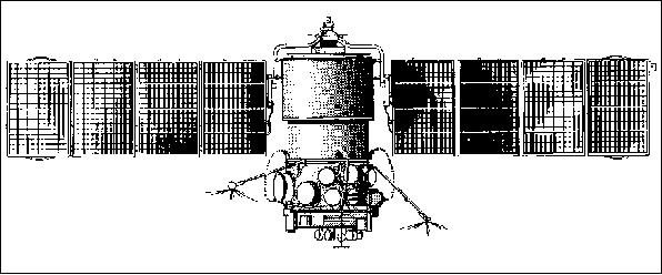
The Meteor-Priroda series is a USSR experimental mission series, considered to be the predecessor of the Resurs-O1 series. Sponsoring agency: ROSHYDROMET. Meteor-Priroda is the first USSR Earth resources satellite series for continuous imaging from space. First launch: July 9, 1974. In 1983 Meteor-Priroda data were used to determine snow depths for all Soviet agricultural regions, to assist in planning the spring work season and to forecast the harvest.
Spacecraft
The spacecraft was 3-axis stabilized with a launch mass of 3800 kg. The Meteor-1 series universal platform was also used for the Meteor-Priroda series up to satellite No. 4. Starting with Meteor-Priroda-5, a Meteor-2 platform was being used.

Orbit: Sun-synchronous polar orbit (starting with Meteor-Priroda-3), altitude = 630 km, inclination = 98º, period = 97-98 minutes, repetition cycle = 16 days. This marked the first sun-synchronous orbit in a mission of the USSR.
Spacecraft | Launch | Period (min) | Perigee | Apogee (km) | Inclin. (º) | Remarks / Sensor Complement | |
Use of Meteor-1 series platform | |||||||
Meteor-P.-1 | 9.7.1974 | 102.6 | 877 | 905 | 81.2 | MSU-M, MSU-S, TV, IR, SHF | |
Meteor-P.-2 | 15.5.1976 | 102.4 | 866 | 908 | 81.2 | MSU-M, MSU-S, IR, SI-GDR, R10-M, SHF | |
Use of Meteor-2 series platform | |||||||
Meteor-P.-3 | 29.6.1977 | 97.5 | 602 | 685 | 97.9 | MSU-M, MSU-S, SI-GDR, R10-M, SHF | |
Meteor-P.-4 | 25.1.1979 | 97.5 | 628 | 656 | 98.0 | MSU-M, MSU-S, SI-GDR, R10-M, | |
Meteor-P.-5 | 18.6.1980 | 97.3 | 589 | 678 | 98.0 | MSU-M, MSU-S, Fragment, R10-M, MSU-SK, MSU-E | |
Meteor-P.-6 | 10.7.1981 | 97.6 | 611 | 688 | 97.9 | MSU-M, MSU-S, R10-M, SHF | |
Sensor Complement
MSS Fragment (Multispectral Scanning System Fragment). Fragment was designed and developed at IKI (Space Research Institute) in Moscow. The instrument is an optomechanical scanning (whiskbroom) system of high resolution [analogous in function to MSS (Multispectral Scanner System) on Landsat]. The optical subsystem (built by VEB Kombinat Carl Zeiss, Jena) employs a Cassegrain telescope with an aperture of 24 cm diameter and a focal length of 1 m. The scan frequency is 13.02 Hz (cross-track direction). The detector system uses an array of 35 photodiodes.
There are eight spectral bands: a) 5 bands are in the spectral range of 0.4-1.0 µm, all with a spatial resolution of 80 m; b) 2 bands in the SWIR range of 1.2 - 1.8 µm with a resolution of 240 m, and c) 1 SWIR band in the range 2.0 - 2.4 µm with a resolution of 480 m. The swath width is 85 km; the instrument data rate is 5.6 Mbit/s. Instrument mass = 280 kg; size: 1.66 m x 1.44 m x 0.73 m; power = 220 W. Extensive pre-launch calibrations were conducted in facilities especially built for Fragment. The first and only launch of MSS Fragment took place on Meteor-Priroda-5 on June 18, 1980. Fragment operated onboard the spacecraft for 4 years. 6) 7)
MSU-S (Multispectral Scanner) of moderate resolution (two-channels). Spectral range: 0.58 - 0.7 µm, and 0.7 - 1.0 µm, resolution = 140 - 240 m, swath width = 1380 km.
MSU-SK (Multispectral Scanner) of moderate resolution with conical scanning capability. Spectral ranges: 0.5 - 0.6, 0.6 - 0.7, 0.7 - 0.8, 0.8 - 0.9 µm. Spatial resolution = 175-243 m (in VIS) and 500 m (in IR); swath width = 600 km
MSU-E (High-Resolution Multispectral Scanner with Electronic Scanning). Three spectral ranges: 0.5 - 0.7 µm, 0.7 - 0.8 µm, and 0.8 - 1.0 µm. Spatial resolution = 28 x 28 m; swath width = 28 km. Spaceborne CCD detector technology was introduced with MSU-E, first flown on the Meteor-Priroda-5 (launch June 18, 1980) spacecraft of the former Soviet Union. MSU-E was built at ISDE (Russian Institute of Space Device Engineering) in Moscow; it featured a CCD line array of 1024 pixels, three parallel line arrays, each of 1024 elements, and provided pushbroom imagery in three spectral bands (visible range). MSU-E provided a nadir view with a FOV of 2.5º. A radiation cooler provided a detector temperature in the range of -30 to -50ºC. Instrument mass of 17 kg. No in-flight calibration was performed. 8)
MSU-M (Multispectral Scanner) of low resolution; swath width = 2000 km; spatial resolution = 1 km x 1.7 km; four spectral ranges: 0.5 - 0.6, 0.6 - 0.7, 0.7 - 0.8, 0.8 - 1.0 µm.
SHF (Passive MW Radiometer) measuring the emission radiation of the atmosphere/ocean system interface at the following microwavelengths/frequencies: 0.8 cm (37.5 GHz), 1.35 cm (22.22 GHz), 1.55 cm (19.4 GHz), and 4 cm (7.5 GHz). The swath width = 800 - 900 km depending on orbit height. Resolution = 1.2º - 3.0º.
SI-GDR (Spectrometer/Interferometer) of the German Democratic Republic (GDR). An infrared Fourier spectrometer (original designation: PM = Profile Module) with the objective of temperature profile measurements in the atmosphere. Spectral range: 6.25 - 25 µm; spectral resolution = 5 cm-1 ; nadir pointing; resolution = 2.2º x 2.4º.
R10-M (Radiation Measurement Complex), analogous to RMK-2
References
1) "The Cambridge Encyclopedia of Space," Cambridge University Press 1990, p. 235
2) The original text was reviewed by Y. V. Trifonow of VNIIEM, Moscow
3) COSPAR-90-Paper by A. Karpov, USSR State Committee for Hydrometeorology, Moscow. Title of paper: "Hydrometeorological, Oceanographic and Earth-Resources Satellite Systems operated by the USSR."
4) http://www.cira.colostate.edu/ramm/hillger/polar-wx.htm
5) V. P. Vassiliev, L .I. Gusev, V. D. Shadgorodsky, J. J. Degnan, "Experimental Verification of the Fizeau Influence on the Reflected Beam Direction in Satellite Laser Ranging," Ninth International Proceedings on Laser Ranging Instrumentation, 1994.
6) "Atlas zur Interpretation von kosmischen Scanneraufnahmen, Multispektralsystem Fragment, Methodik und Ergebnisse," Akademie-Verlag, Berlin, Nauka Verlag, Moscow, 1989
7) Information provided by Ian Ziman of IKI, Moscow
8) A. S. Selivanov, Y. M. Tuchin, M. K. Naraeva, B. I. Nosov, "Experimental Satellite System for Earth Monitoring," Issledovanie Zemli iz Kosmosa, W 5, 1981
This description was provided by Herbert J. Kramer from his documentation of: "Observation of the Earth and Its Environment: Survey of Missions and Sensors" - comments and corrections to this article are welcomed by the author (eoportal@symbios.space).