NovaSAR-1
EO
Atmosphere
Land
Multi-purpose imagery (land)
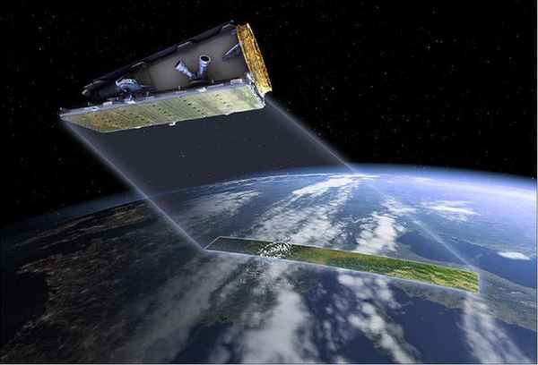
Launched in September 2018, the minisatellite NovaSAR-1 is a technology demonstration mission with a design life of seven years, designed to test the capabilities of a new low cost S-band SAR (Synthetic Aperture Radar) platform. The spacecraft and payload were developed collaboratively by SSTL (Survey Satellite Technology Ltd.) and Airbus Defence & Space Ltd, with funding from organisations in the UK, India, Australia and the Philippines.
Quick facts
Overview
| Mission type | EO |
| Agency | UKSA, ISRO, CSIRO, Space-Eyes, DOST-ASTI |
| Mission status | Operational (nominal) |
| Launch date | 16 Sep 2018 |
| Measurement domain | Atmosphere, Land, Snow & Ice |
| Measurement category | Multi-purpose imagery (land), Vegetation, Sea ice cover, edge and thickness, Atmospheric Winds |
| Measurement detailed | Land surface imagery, Vegetation type, Land cover, Sea-ice cover, Oil spill cover, Above Ground Biomass (AGB), Vegetation Canopy (cover) |
| Instruments | S-Band SAR, AIS |
| Instrument type | Other, Imaging microwave radars |
| CEOS EO Handbook | See NovaSAR-1 summary |
Summary
Mission Capabilities
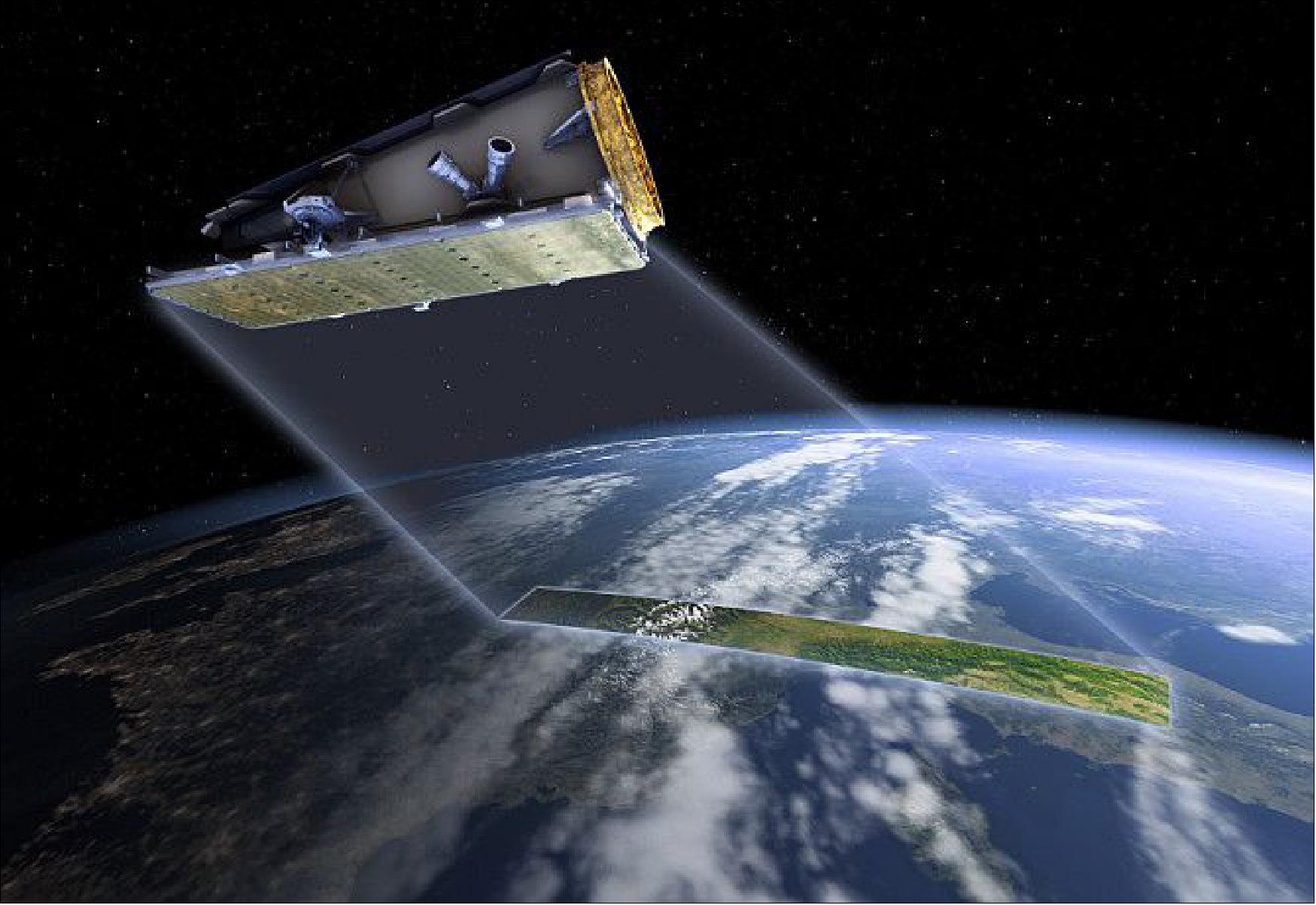
NovaSAR-1 features an S-SAR (S-band Synthetic Aperture Radar) and an AIS (Automatic Identification System) to provide medium resolution imaging. The S-SAR instrument is a derivative from Astrium’s airborne radar demonstrator technologies and is designed for low-cost programmes and optimised for shared launch opportunities. The underutilised S-band frequency provides data relating to vegetation penetration, soil moisture, flood monitoring, forest monitoring and maritime applications. The satellite can image through all weather conditions and during the night, offering a valuable data advantage to many of these industries. S-SAR is designed to support four operational modes: ScanSAR, Maritime Surveillance, Stripmap and ScanSAR Wide. The AIS is a secondary payload instrument supplied by COM DEV to provide additional information on the identification of detected ships and highlight non-AIS transmitting vessels located in restricted areas.
Performance Specifications
The S-SAR instrument offers a variety of modes featuring different resolutions and swath widths. The ScanSAR mode covers a swath width of 50-100 km at a spatial resolution of 20 m, whilst the ScanSAR Wide mode offers a larger swath width of 100-50 km at a resolution of 30 m. The Stripmap mode has the finest resolution at 6 m, covering a swath width of 15-20 km. The final mode, Maritime mode, is an experimental mode used for the detection of ships in the open ocean. At a medium resolution of 30 m, the large swath width of up to 750 km enables effective ship detection via azimuth ScanSAR imaging. The AIS instrument is used simultaneously to collect data over the same area to provide enhanced ship detection and identification of non-AIS transmitting vessels.
Whilst there is only one satellite currently in operation, the target is a constellation of three satellites for more frequent revisit times. Currently operating in a sun-synchronous orbit at an altitude of 580 km and inclination of 97.5°, NovaSAR-1 has a period of 96.3 minutes and a repeat cycle of 16 days.
Space and Hardware Components
Developed under a joint initiative by SSTL and Astrium, NovaSAR-1 combines the heritage avionics of the SSTL-300 bus with a new structural design to accommodate the payload. To provide a highly reliable system with a design lifetime spanning over seven years, the bus platform makes use of wide-ranging redundancy architectures. There are two key platform units that are each connected to a redundant CAN (Controller Area Network) data bus to allow cross strapping of units. The spacecraft has a mass of 430 kg, featuring a xenon propulsion system and S-band TT&C (Telemetry, Tracking and Command) data transmission.
NovaSAR-1 — Low Cost S-band SAR Mission on a Minisatellite
Spacecraft Launch Mission Status Sensor Complement References
NovaSAR-1 is a joint technology demonstration initiative of SSTL (Surrey Satellite Technology Ltd.), UK, and Airbus DS (former EADS Astrium Ltd, Stevenage, UK), funded by the UK Government via the UKSA (UK Space Agency). The overall objective is to make SAR (Synthetic Aperture Radar) observation missions more affordable to a customer base and to open up new application-oriented in the microwave region of the spectrum.
In the past decade, programs such as the DMC (Disaster Monitoring Constellation) have proven that a low cost, small satellite approach can provide solutions for medium resolution EO (Earth Observation) applications. However, these have all been optical missions. SAR missions have well known night time and all weather advantages over optical missions but have not yet made the same evolutionary step. To date, SAR satellites have mostly served large budget, institutional missions with a performance driven, rather than applications driven, design. 1) 2) 3) 4) 5) 6) 7) 8) 9)
A SAR payload design, which optimises all imaging parameters (resolution, swath, sensitivity, duty cycle etc.), leads to a satellite design which is at odds with a low cost approach. An applications driven approach, focused on medium resolution applications, enables solutions that can make the evolutionary step to the low cost, small satellite arena. In the same way that low cost optical satellites have enabled numerous optical EO programs, a low cost approach can bring SAR solutions to a wider EO user community.
Rather than follow a traditional development with a flow down of requirements from an external customer, our approach has been to design a baseline mission which answers the question “what imaging performance can we achieve with a spacecraft that can be built and operated at low cost, and is compatible with low cost launches?” This approach leverages heavily SSTL’s experience of low cost optical EO missions and Astrium’s experience of SAR missions.
NovaSAR-1 provides medium resolution (6-30 m) imagery ideal for applications in the following fields:
- flood monitoring
- agricultural crop assessment
- forest monitoring (temperate and rain forest)
- land use mapping
- disaster management
- maritime applications (e.g. ship detection, oil spill monitoring, maritime safety, and security of defence applications). 10)
However, applications that can be served by a medium resolution (10-30 m) system are not limited to the list above.
In November 2011, the British government announced an investment of £ 21 M to SSTL to assist in the development and launch of the first NovaSAR spacecraft, an innovative and highly competitive new spaceborne radar remote sensing program, in the international market. 11) 12) 13)
Spacecraft
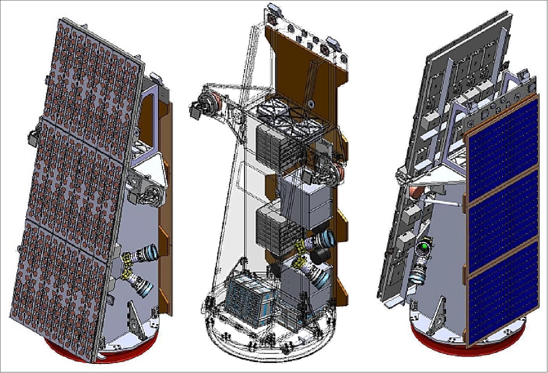
The industrial team developing the NovaSAR spacecraft is led by SSTL. NovaSAR-1 combines heritage avionics (of the SSTL-300 bus) with a new structural design, to accommodate a payload, developed under a joint initiative between SSTL and Astrium. The design lifetime of the satellite is 7 years. A trade-off between imaging requirements, drag and propulsion subsystem mass/NRE/costs settled on an optimum orbital altitude of 580 km. 14) 15)
EPS (Electrical Power Subsystem):
Super capacitor experiment: The objective is to test a new energy storage technology in space - by providing a high-power energy source for relatively short operating times (to make for instance a radar operation possible on a small spacecraft. 16)
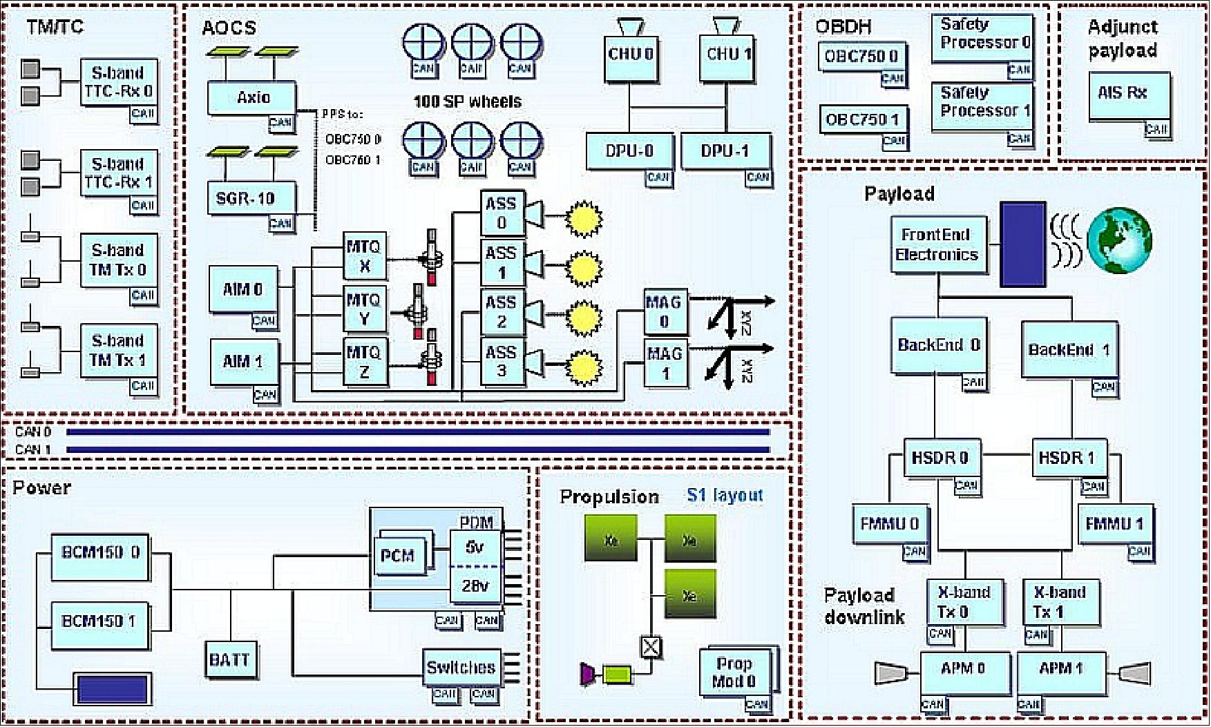
To provide a highly reliable system with a high probability of meeting the 7+ year lifetime requirement, SSTL’s platforms make use of wide-ranging redundancy architectures. The EPS architecture is shown in Figure 2. There are two redundant CAN data buses and two of each of the key platform units, each connected to each data bus allowing cross strapping of units. Additionally some of the units provide internal redundancy e.g. triple redundant program memory and EDAC protection on the data memory.
SSTL is developing a prototype of a super-capacitor based power system, including a capacitor charge regulator (with maximum peak power tracking and control charging), a cell monitoring and management module (to monitor and protect each cell), and capacitor-bank (energy storage module). A COTS LIC (Lithium-Ion Capacitor) is employed in the capacitor-bank. The LIC uses activated carbon as a positive electrode that makes an electric double layer, and has lithium-ions pre-doped into a carbonaceous negative electrode.
Avionics: NovaSAR-1 features the same avionics as those on the on the SSTL-300 bus of NigeriaSat-2.
The NovaSAR-1 spacecraft has a mass of 430 kg, a xenon propulsion system, and a design life of 7 years.
RF communications: The TT&C data are transmitted in S-band (2025-2110 MHz, 2200-2290 MHz); the payload data are downlinked in X-band (8.025-8.4 GHz) at a data rate of 500 Mbit/s. An onboard data storage capacity of 544 GByte is provided (Ref. 15).

Development Status
• August 16, 2018: SSTL has signed an agreement with Antrix Corporation Limited, the commercial arm of ISRO ( Indian Space Research Organisation), for the launch into a 580 km sun-synchronous orbit of NovaSAR-1 (also referred to as NovaSAR-1), a small Synthetic Aperture Radar (SAR) satellite, and SSTL S1-4, a high resolution Earth observation minisatellite. The two satellites will launch on PSLV-C42, due to lift-off in September 2018. 18)
- NovaSAR-1 is a technology demonstration satellite mission designed to test the capabilities of a new low cost S-band SAR platform. The spacecraft was designed and manufactured by SSTL, with an S-band SAR payload developed by Airbus Defence and Space in Portsmouth, and an Automatic Identification Receiver (AIS) supplied by COM DEV to track ships at sea. NovaSAR-1 will be operated from SSTL’s Spacecraft Operations Center in Guildford, UK.
- The UK Space Agency has invested £21M in the development of NovaSAR-1 and will benefit from access to data from the spacecraft, significantly boosting the UK’s sovereign Earth observation capabilities and leveraging additional inward investment to the UK by creating highly skilled jobs in the UK space industry, and stimulating the growth of data analysis services.
- Also on the PSLV-C42 launch will be the SSTL S1-4, a sub-meter resolution Earth observation satellite with a mass of 440 kg that will further enhance SSTL’s existing in-orbit observation capabilities.
• September 26, 2017: SSTL signed an agreement in Adelaide today at the IAC (International Astronautical Congress) to provide Australia’s CSIRO (Commonwealth Scientific and Industrial Research Organisation) a 10% share of the tasking and data acquisition capabilities from NovaSAR-1, a first-in-class small radar satellite due for launch later this year. 19)
- NovaSAR-1 is a technology demonstration mission designed to complement much larger, complex radar satellites with a smaller, lighter and more cost effective platform that delivers Earth observation Synthetic Aperture Radar imagery day and night, and through cloud cover. Managing the energy use on board the small SAR platform has been made possible by using a new, highly efficient S-band solid-state amplifier technology and flying an innovative S-band SAR payload developed by Airbus UK in Portsmouth .
- Speaking at the IAC in Adelaide, Luis Gomes, SSTL’s Commercial Director said “We are delighted to be here in Adelaide for the IAC, and to see the Australian government’s “Big Country, Big Sky, Big Ideas” slogan underpinned by today’s announcement of our partnership with CSIRO on the NovaSAR-1 mission. We anticipate that CSIRO will greatly enhance Australia’s sovereign Earth observation capability with the addition of SAR data, particularly for this continent which has a tropical climate and a large coastline territory.”
- Gomes also confirmed that further data shares on the mission are available, commenting “With the launch of the satellite due later this year, we have a number of discussions open with potential partners on the mission but we also welcome new partners looking to take a data and tasking share in NovaSAR-1.”
- The agreement gives CSIRO tasking priorities and the ability to access the raw data directly from the satellite, and a license to use and share the data with other Australian companies and organisations over an initial 7 year period.
• The NovaSAR-1 payload was delivered by Airbus DS UK to SSTL for platform integration in November 2015.
• The flight build commenced in January 2014 and was completed on schedule and on budget in July 2015.
• The Engineering Qualification program was completed in Q1 2014.
Launch
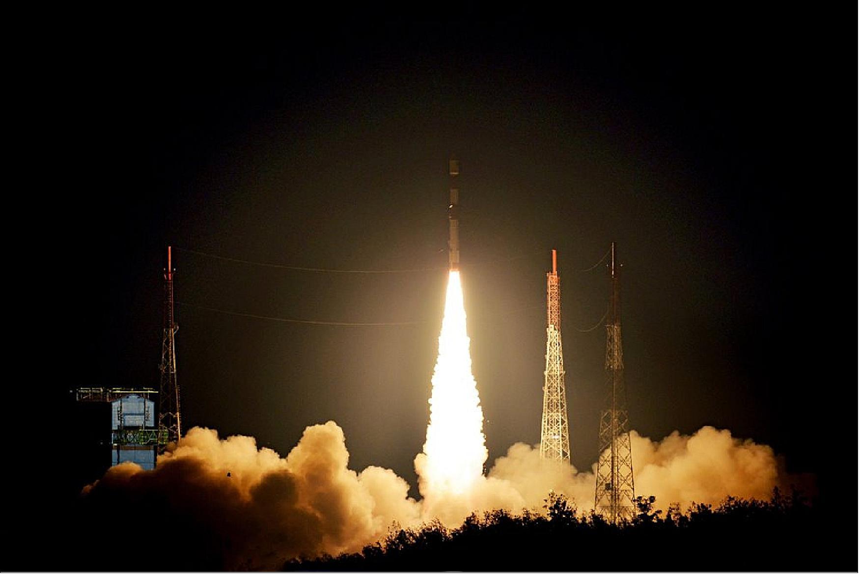
The NovaSAR-1 minisatellite, along with SSTL S1-4, a high resolution Earth observation minisatellite of SSTL, were launched on 16 September 2018 (16:38 UTC) on the PSLV-C42 vehicle of ISRO from SDSC (Satish Dhawan Space Center) from SHAR, ISRO's launch center on the south-east coast of India, Sriharikota. Launch provider: Antrix Corporation Ltd., the commercial arm of ISRO. 20) 21)
Sun-synchronous orbit: altitude of ~580 km, inclination of 97.5º, LTAN (Local Time on Ascending Node) = 10:30 hours.
For a description of the SSTL S1-4 mission, see the DMC3 file (Disaster Monitoring Constellation-3) / TripleSat Constellation of 21AT / Beijing-2 on the eoPortal. The SSTL S1-4 satellite is identical to the three DMC3 satellites in the TripleSat Constellation, launched in 2015. It has a mass of 440 kg and is capable of acquiring multiple targets in one pass and will utilise spot, strip and mosaic imaging modes and 45 degree off-pointing agility for a range of applications including urban planning, agricultural monitoring, land classification, natural resource management and disaster monitoring.
Mission Status
• July 8, 2021: Australian researchers in industries like agriculture and natural disaster management gained the ability to apply to direct the Earth observation satellite NovaSAR-1 by accessing Australia’s share of the satellite, managed by CSIRO, Australia’s national science agency. 22) It marked the first time Australia has managed its own source of Earth observation data, contributing to the growth of the nation’s space industry. Satellite data was downloaded to a receiving station near Alice Springs owned by the Centre for Appropriate Technology (CfAT) which is Australia’s first and only Aboriginal-owned-and-operated ground segment service provider. Applications to use the NovaSAR-1 national facility will be reviewed by an independent committee and allocated based on the scientific merit of the proposed research. www.csiro.au/novasar allows you to access NovaSar data and the application process.
• April 27, 2021: Surrey Satellite Technology Ltd (SSTL) has signed an agreement with Space-Eyes (Channel Logistics USA, LLC Delaware, doing business as “SpaceEyes. LLC”) to provide a share of the tasking and data acquisition capabilities from NovaSAR-1. SSTL will lease imaging payload capacity to Space-Eyes for the lifetime of the satellite, designed to be over 7 years, and will retain ownership of the spacecraft and perform in-orbit satellite operations from its UK Headquarters. Space-Eyes will integrate the SAR images with contextual maritime threat evaluation data for the maritime domain with its CATE™ (Computer Assisted Threat Evaluation) Analytics technology to deliver tactical intelligence, surveillance and reconnaissance. 23)Space-Eyes provides Synthetic Aperture Radar satellite collections across all weather and lighting conditions. The data is integrated with related geospatial and contextual maritime data and analysed automatically by CATE™ for supply chain risks and maritime domain awareness threats, addressing emerging opportunities in autonomous shipping, service provider driven block-chains and asset security in energy's downstream and upstream markets.
- NovaSAR-1 was the world’s first commercial SAR satellite to be operated at a 10:30 equator crossing time, providing time diversity for radar observations by affording increased daylight imaging opportunities in addition to night acquisitions. The SAR payload has a dedicated maritime mode designed with a very wide swath width of 400 km to enable the monitoring of the marine environment and provides direct radar ship detection information simultaneously with AIS ship tracking data to assist with the identification and tracking of sea-going vessels. NovaSAR-1 was designed and manufactured by SSTL, with an S-band SAR payload developed by Airbus Defence and Space in Portsmouth, UK and an Automatic Identification Receiver supplied by Honeywell Aerospace. Mission partners previously signed up for capacity from NovaSAR-1 include the UK Space Agency, Australia’s Commonwealth Scientific and Industrial Research Organisation (CSIRO), DOST-ASTI (Philippines) and the Indian Space Research Organisation (ISRO).
• November 7, 2019: SSTL signed an agreement with the Republic of the Philippines’ Department of Science and Technology-Advanced Science and Technology Institute (DOST-ASTI) to provide a share of the tasking and data acquisition services from NovaSAR-1, the innovative small S-band radar satellite launched into a 580 km sun synchronous orbit in September 2018. 24) The agreement gives DOST ASTI tasking priorities over the Philippines and the ability to access the raw data directly from the satellite, with a license to use and share the data with their partners over an initial 5 year period, extendable to the actual lifespan of the satellite. SAR (Synthetic Aperture Radar) has the ability to image the Earth through cloud cover and at night, and DOST-ASTI will use data from NovaSAR-1 in support of a number of applications, including disaster monitoring, agricultural and forestry management, and coastal and maritime applications such as ship detection.
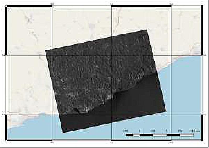
- Two sample SAR images of the Philippines acquired by NovaSAR-1 have been released. The target area for the first image acquisition was Cebu city and the nearby Mactan-Cebu International Airport. The captured image shows sea-going vessels around the shipping port together with the rugged terrain of the interior of Cebu Island. Masbate Island in the Bicol region of the Philippines serves as the target area of the second image acquisition. The resulting image reveals a crater site hidden by forest canopy that is not visible in optical satellite images. Other features such as aquaculture sites along the coast and the rolling hills in the central region of the island were also captured in the image.

• October 2019: Space borne radar systems provide an attractive means to observe the Earth from space at times when optical systems cannot be used efficiently, for instance at night time or in areas with poor lighting such as over the poles, or in areas with extensive clouds or haze. Space borne radar can also be used in some cases to penetrate foliage, soil or water which has been exploited for instance in archaeology. Furthermore, radar can also provide some information about the properties of the illuminated target that can some-times not be established through other means, due to the reflection, absorption and scattering characteristics of the target which change with wavelength and polarisation. 25)

- Traditionally such space borne radar systems have required relatively large satellites. There are several reasons for this. Firstly, as an active Earth Observation system the amount of Radio Frequency transmission power is high in the kilowatt range leading to designs where that power is provided directly from solar panels. Secondly, spacecraft system design tends to drive solutions towards large area antennas. Until quite recently only major government agencies have developed such spacecraft. Their scientific or national needs have driven these missions to serve multiple applications, and as the expensive missions must serve all of the user community they include high levels of performance or features. Radar spacecraft system designs tend to lead to solutions in 6 am-6 pm sun-synchronous orbits where the power generation and thermal design are most easily dealt with. As there are not many other spacecraft that benefit from such an orbit, the only limitation to the size of the SAR spacecraft tends to be the size of the launch vehicle.
SAR Mission | Launch Year | Mass (kg) | Imaging Frequency Band |
ERS-1 | 1991 | 2384 | C |
ERS-2 | 1995 | 2384 | C |
RADARSAT-1 | 1995 | 2200 | C |
SARLupe | 2006 | 770 | X |
ALOS-1 | 2006 | 4000 | L |
TerraSAR-X | 2007 | 1230 | X |
RADARSAT-2 | 2007 | 2200 | C |
COSMO-SkyMed | 2007 | 1700 | X |
TecSAR | 2008 | 300 | X |
TanDEM-X | 2010 | 1340 | X |
HJ-1C | 2012 | 890 | S |
RISAT-1 | 2012 | 300 | X |
KOMPSAT-5 | 2013 | 1400 | X |
Sentinel-1A/B | 2014 | 2300 | C |
ALOS-2 | 2014 | 2120 | L |
Sentinel-1A/B | 2016 | 2300 | C |
IceEye-1 | 2018 | 80 | X |
NovaSAR-1 | 2018 | 450 | S |
Capella | 2018 | 40 | X |
PAZ | 2018 | 1350 | X |
RISAT-2B | 2019 | 615 | X |
Harbinger | 2019 | 150 | X |
- The market for SAR data is projected to be worth USD 1.6 billion in revenues by 2027, with 2018 figures being just over half of that. Typical pricing for SAR data varies from around USD 85-150/km2 today, falling to around one-third of that over the coming decade. Using these figures, the current worldwide annual data sales can be estimated to be 8 million km2. The value of SAR spacecraft and commercial data capacity far outstrips the market. Furthermore, some data is made available for free from the Sentinel-1 spacecraft, although the satellite is not available for casual tasking requests. Traditional SAR missions developed by governmental agencies tend to be designed to meet highly derived and rigid performance parameters. Systems designed to support a service and a business case may see a more iterative, rather than cascaded flow down, type of requirements development. Systems designed for surveillance type applications (e.g. security and environmental monitoring) will typically be driven by resolution and revisit where object detection and feature extraction, often relating to human activity, is required. Where classification of distributed targets is required (e.g. agricultural and environmental assessment) sensitivity and radiometric aspects are more important.
• August 2019: The first NovaSAR image turned out to be a fortuitous anomaly and there followed a period of fixing bugs in mode definitions, tasking software, on board computer software and ground data processing. In parallel, commissioning activities, relating to both space segment and ground segment, progressed. The NovaSAR radar antenna is a planar phased array. Although the aperture is small for this type of system it has sufficient phase centers to support flexible modes of operation. A number of modes have been implemented and modes will be added through the mission at the request of mission partners. The following operational modes in Table 2 have so far been implemented and functionally tested. 29)
Operational mode | Resolution (m) | Swath (km) | Polarisation |
Stripmap | 6 | 13-20 | HH or VV |
Stripmap (wide swath) | 6 | 18-25 | HH |
Stripmap x-polarisation) | 6 x 10 | 20 | HV |
Maritime (scanSAR) | 6 x 14 | 400 | HH |
ScanSAR | 20 | 50-100 | HH or VV |
Dual polarisation | 20 | 50-60 | HH+VV |
Tri-polarisation | 30 | 50-56 | HH+VV+HV |
- Post launch commissioning activities have included a calibration campaign on the SAR payload to optimise and characterise its performance. CarbSAR utilises the platform heritage of the Carbonite optical satellite series and combines it with an innovative deployable X-band SAR antenna and payload. In summary, as SAR systems become more popular with commercial companies supporting data analytics applications, there is significant room for a variety of systems that utilise small SAR spacecraft in order to address some specific markets. Such small SAR spacecraft may need to be deployed into multi-plane constellations in order to observe targets at different times of the day. NovaSAR-1, and its follow-on SAR concept CarbSAR address two particular variants of small SAR spacecraft addressing very specific applications, and have been presented as examples of how small SAR missions can help address specific markets and end-users.
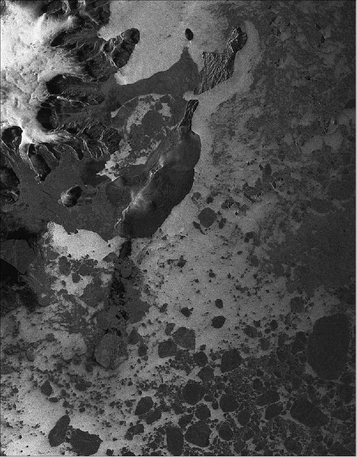
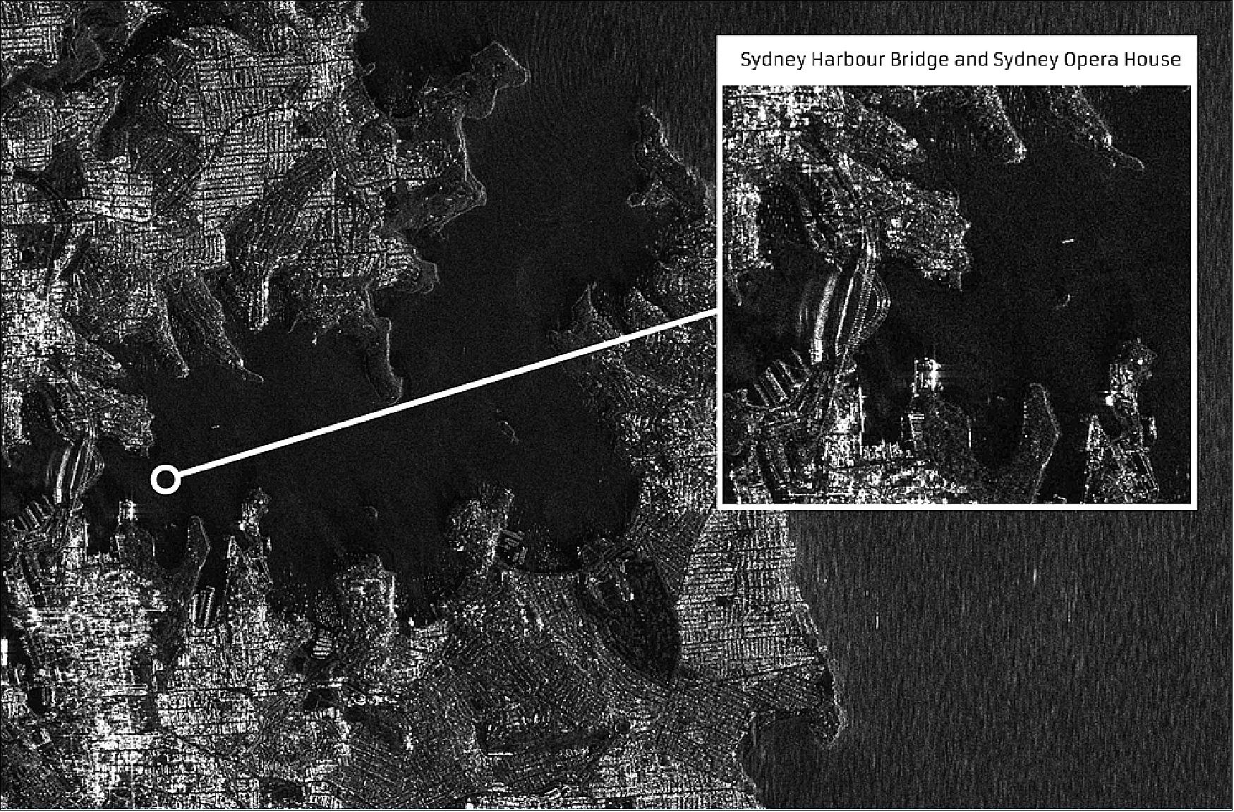
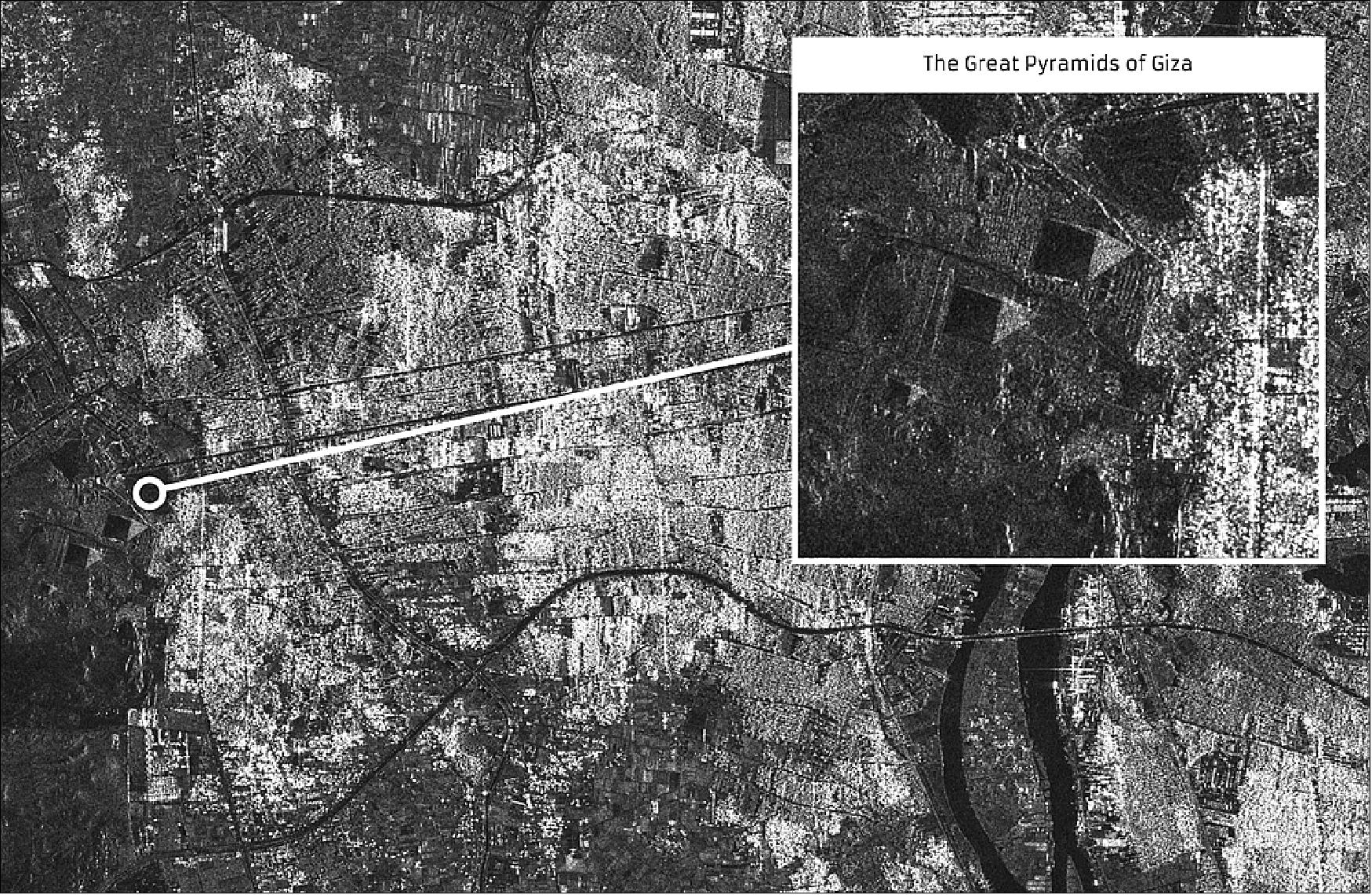
• November 23, 2018: SSTL has today released the first SAR (Synthetic Aperture Radar) images taken from orbit by NovaSAR-1, a technology demonstration mission launched into a 580 km sun-synchronous orbit on 16 September 2018. 30)The S-band SAR sample images released today have been acquired using the satellite’s stripmap mode at 6 m resolution and are 20 km wide by 87km long. They were taken over Sydney Harbor and Cairo, Egypt. Mission partners signed up for capacity from NovaSAR-1 include the UK Space Agency, Australia’s Commonwealth Scientific and Industrial Research Organisation (CSIRO), and the Indian Space Research Organisation (ISRO). The image of Sydney was taken at night and cropped images taken from the original show Sydney Harbor Bridge, Sydney Opera House, The Royal Botanic Garden, Bondi beach and several boats crossing the harbor. A second close up from the original image shows small boats moored in the natural harbor at Church Point, north of Sydney in a demonstration of the usefulness of SAR for detecting vessels of many different sizes and types, particularly at night or through cloud cover. The image of Cairo shows the River Nile flowing from Upper Egypt through Cairo and down towards Beni Suef. Urbanisation, cultivation along the Nile, and the non-irrigated desert areas are clearly distinguishable. Cropped images taken from the original show The Great Pyramids of Giza, and the Red Pyramid and Bent Pyramid near Dahshur.
- Synthetic Aperture Radar is a powerful tool for monitoring the Earth from space due to its ability to see through clouds and image the Earth night and day. NovaSAR-1 was designed and manufactured by SSTL, with an S-band SAR payload developed by Airbus Defence and Space in Portsmouth and an AIS (Automatic Identification System) receiver supplied by Honeywell Aerospace. The SAR payload has a dedicated maritime mode designed with a very wide swath area of 400 km to enable the monitoring of the marine environment, and will provide direct radar ship detection information simultaneously with AIS ship tracking data to assist with the identification and tracking of sea-going vessels. In addition to operating in maritime mode, NovaSAR-1 has been optimised with three additional imaging modes, including a six meter resolution imaging mode, for a range of other applications such as flood monitoring and agricultural and forestry applications. NovaSAR-1 has operated in orbit from SSTL’s Spacecraft Operations Centre in Guildford UK.
Sensor Complement
S-SAR (S-band Synthetic Aperture Radar)
The innovative S-SAR payload is being developed collaboratively by Airbus Defence & Space Ltd (formerly EADS Astrium Ltd.) of Portsmouth, UK, and SSTL, the payload activities are led by Airbus DS, UK. 31) 32) 33) 34) 35)
Background: The S-SAR payload is a derivative from Astrium’s airborne radar demonstrator technologies with the benefit of significant heritage and risk reduction from the airborne demonstrator development: 36)
• architecture and implementation of back end radar electronics
• development and demonstration of imaging modes
• provision of data sets to support proving of SAR applications
• key enabler for low cost approach to space-based radar instruments.
Demonstrator developed by Astrium over the last decade:
• designed and built under UK government contract and Astrium R&D
• system/instrument exercised on extensive flight trials campaigns
• has been an important tool as a radar test bed to provide support to SAR research and development
• SAR image processor developed to evaluate acquired imagery.
Detailed trade-off analyses were performed to ascertain the performance of an S-band Phased Array Antenna of this architecture, with many phase-center configurations considered. The result is an innovative Front-End Architecture (low phase center count) with 18 x 100 W phase centers, arranged in a 3-column by 6-column configuration, all accommodated in a 3 m x 1 m panel.
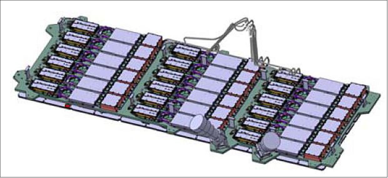
The S-band antenna is a microstrip patch phased array of ~ 3 m x 1 m in size. The antenna size drives the satellite size which has been deliberately constrained to meet low cost launch vehicle requirements.
The payload can transmit and receive on both horizontal and vertical polarisations. The baseline payload configuration can be operated to produce imagery in polarimetric mixes that include single polar (HH, VV), dual polar (any 2 from HH, VV, HV or VH), tri-polar (any 3 from HH, VV, HV or VH), or quad polar (HH, VV, HV & VH) .
Imaging frequency band | S-band (3.1-3.3 GHz, wavelength of ~ 10 cm) |
SAR antenna | - Microstrip patch phased array (3 m x 1 m) |
Peak RF power | 1.8 kW |
Imaging polarisation | Single polar, dual polar or triple polar |
Duty cycle | 2-3 minutes per orbit (equates to single image 800 km long) |
Payload data memory | 544 GByte |
The payload front-end RF electronics are mounted on the reverse side of the antenna panel making the payload front-end self-contained. The NovaSAR platform has been designed to support payloads that operate in different frequency bands.
Traditional space qualified TWTA (Traveling Wave Tube Amplifier) reflectors offer good efficiency but are relatively expensive. GaAs SSPAs (Solid-State Power Amplifiers) can be implemented using COTS technology but do not offer such good efficiency. Recently, the terrestrial use of GaN (Gallium Mitride) technology in SSPAs has become mature at frequencies up to S-band and offers efficiencies > 40%. Therefore, our payload has been designed around S-band GaN SSPAs.
By using GaN SSPAs and designing for an imaging duty cycle of ≥ 2 minutes/orbit (~2%) the orbit average power consumption of the payload is in the region of 100 W. This greatly helps to reduce the overall spacecraft mass and volume, and hence costs associated with manufacturing, test, transportation, launch etc. The 2 minute imaging period has been selected as a baseline to enable an 800 km long strip of imaging each orbit that is well suited to regional observations, comparable with the size of many nation states. In fact, depending on operational mode and downlinking opportunities, larger payload duty cycles can also be supported by the NovaSAR-1 satellite providing the overall 2% duty is respected across a number of orbits.
The payload can transmit and receive on both horizontal and vertical polarizations. The baseline payload configuration can be operated to produce imagery in polarimetric mixes that include single polar (HH, VV), and then by trading swath width and/or resolution for more diverse polarimetric capability, dual polar (any 2 from HH, VV, HV or VH) or tripolar (any 3 from HH, VV, HV or VH).
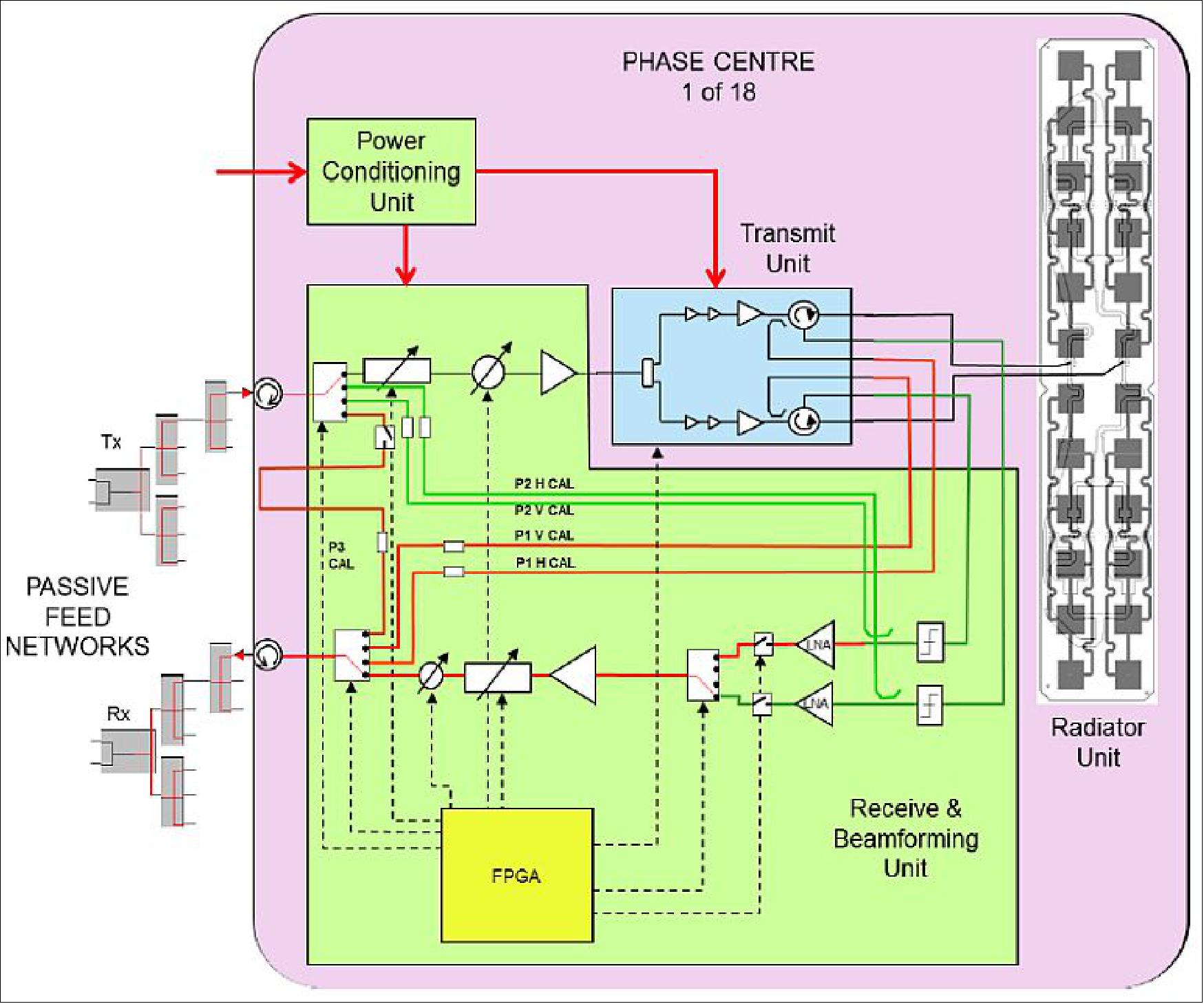
The front surface of the payload frontend consists of the SAR antenna panel with a total of 18 pairs of sub-arrays, each pair forming an individually controllable phase center. The payload frontend RF electronics are mounted on the reverse side of the antenna panel, making the payload frontend self-contained. Six beam control units apply transmit and receive phase adjustments to the eighteen phase centers. Each phase center consists of a transmit unit (100 W RF o/p), a power conditioning unit, a receive unit and a radiator unit. The radiator units are arranged in three columns of six sub-array pairs, each having 24 patches (Figure 21).
This arrangement enables ScanSAR modes with up to around five subswaths with acceptable grating lobe performance. In fact, the use of the longer wavelength at S-band improves the grating lobe performance, enabling more elevation steering than would be possible with just six elevation phase centers at shorter wavelengths. With each phase center delivering around 100 Watts of peak RF power, GaN devices were readily available, and measures to avoid multipaction remained practicable. The total DC power demand was also kept within achievable limits for the small satellite platform with this arrangement.
Bandwidth: With an ITU regulation bandwidth limit of 200 MHz at S-band, the six-element subarrays are sufficiently short for this bandwidth to be readily achieved. However, in terms of power aperture product, the need for credible sensitivity performance limited the bandwidth used on NovaSAR-1 to around 100 MHz, even though the payload can implement up to 200 MHz.
Antenna size considerations: Clearly a 3m2 antenna will be restricted in terms of access capability due to early range ambiguity degradation with increasing incidence angle. Indeed, an S-band SAR solution to access out to 50° incidence (single-polar) would typically need around 14m2 of antenna area. However with careful tuning of the processed Doppler bandwidth and the pulse repetition frequency, an antenna area of just 3m2 can deliver access out to 31° with acceptable ambiguity performance, achieving an access width of around 125 km for 20-31° incidence. Additional access width can be achieved (for compatible applications) by venturing below the traditional 20° incidence angle lower limit. Extending down to 16° incidence, for example, widens the access to 165 km.
It is important to note that the design of the front-end for NovaSAR-1 provides a fully scalable solution, so that a larger antenna can easily be realised simply by building more of the same phase center units and configuring them with the required number of rows and columns. The performance and access will then improve accordingly.
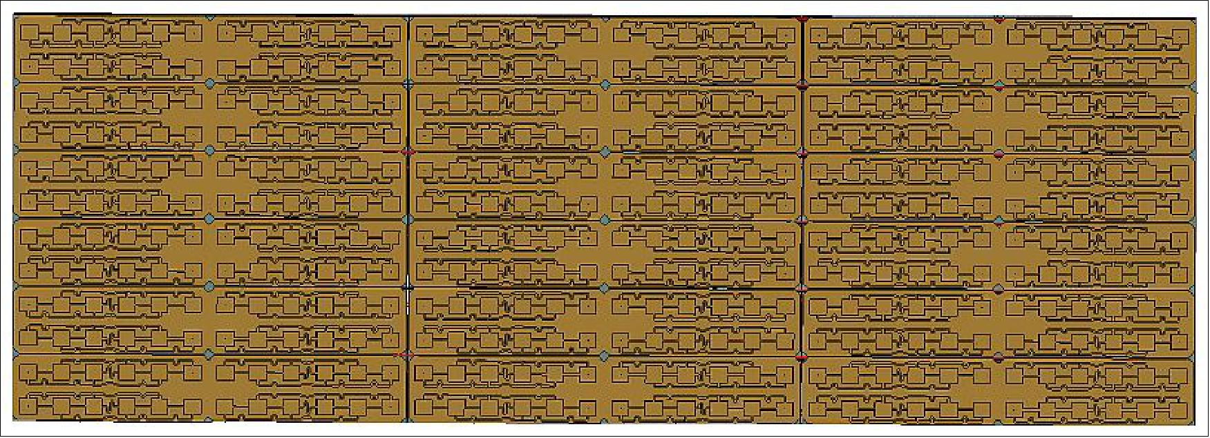
The NovaSAR-1 platform has been designed to support payloads that operate in different frequency bands. Efficient SSPA technologies in other bands are being investigated so that alternate payload frontends can be implemented in the future.
The applications focused approach to the NovaSAR-1 system design has resulted in a platform where both solar panels and the payload antenna can follow fixed, body mounted forms. Hence, the satellite is without deployable appendages, a unique achievement for a SAR satellite.
Baseline imaging modes: An orbit altitude of 580 km has been used to derive the baseline imaging modes given in Table 5. Mode 1 is expected to be the mode most commonly used for the target applications identified. Mode 2 is an unconventional, ultra-wide swath mode intended for ship detection. Modes 1, 2 and 4 are ScanSAR modes. Mode 3 is a Stripmap mode which trades swath width for an improved resolution. However, this reduced swath can be selected from a 150 km access range. Mode 4 is similar to mode 1, but trades resolution to get a wider swath. Modes 1, 3 and 4 have options to increase the available incidence angles and reduce revisit times.
Maritime Mode: An additional, experimental, mode was also defined, known as Maritime Mode, which implements a novel low PRF mode for wide-area ship detection in the open ocean. This is expected to enable effective ship detection via deliberately azimuth ambiguous ScanSAR imaging over a swath more than 400 km wide in the 32-56° incidence angle range. Analysis of S-band airborne imagery of ships using the Airborne SAR Demonstrator developed at Airbus DS in Portsmouth has enabled tuning of the baseline mode design to maximise detection probability and swath width, while maintaining an acceptable false alarm rate of less than 1 image pixel in 107.
Polarimetric capability: Since the antenna is dual polarised (H and V), the instrument is capable of transmitting H or V pulses. To keep cost low, a single receive chain is implemented, but this can receive either H or V in any given echo window, enabling incoherent polarimetric imaging to be acquired. Sensitivity is compatible with primarily using HH and/or VV imaging, since signal to noise ratios will be limited in cross-polar operation for typical rural distributed scenes. However cross-polar operation is available and may also be useful in some circumstances, for example for detecting ships at low incidence angles where unwanted sea clutter will be heavily attenuated in cross polar imagery while the target cross section remains high.
Mode | Resolution | Incidence angles | Swath width | Sensitivity (NESZ) | Typical ambiguity ratio | No of looks |
1: ScanSAR | 20 m | 16-26º | 100 km | < -18 dB | < - 16 dB | 4 |
25-30º | 55 km | < - 18 dB | ||||
2: Maritime Surveillance | 30 m | 48-73º | 750 km | < - 12 dB | <-18 dB (range) | N/A |
3: Stripmap | 6 m | 16-31º | 15-20 km | < - 18.5 dB | < - 16 dB | 3.7 |
16-34º | 15-20 km | < - 17.5 dB | ||||
4: ScanSAR Wide | 30 m | 15-29º | 150 km | < - 19 dB | < - 16 dB | 4 |
22-31º | 100 km | < - 19 dB |
The payload is highly flexible and is capable of delivering a wider range of imaging modes than those baseline modes presented in Table 5 which have been designed for maximum coverage. In-orbit tuning of beam shape and PRF (Pulse Repetition Frequency) can be used to define new modes.
While the NovaSAR-1 satellite will be launched in 2016, the target is a constellation of three satellites for frequent revisit times. Table 6 gives an overview of the revisit times. 37)
Mode | Resolution | Incidence angles | Swath width | Average revisit times – | Average revisit times – | ||
1 satellite | 3 satellites | 1 satellite | 3 satellites | ||||
1: ScanSAR | 20 m | 16-30º | 50-100 km | 4.4 | 1.5 | 1.3 | 0.4 |
2: Maritime Surveillance | 30 m | 48-73º | 750 km | 0.9 | 0.3 | 0.5 | 0.2 |
3: Stripmap | 6 m | 16-31º | 13-20 km | 3.2 | 1.1 | 0.9 | 0.3 |
4: ScanSAR Wide | 30 m | 15-32º | 55-140 km | 3.7 | 1.2 | 1.0 | 0.3 |
Ship detection is one of the main SAR applications since the ships are usually built from large metal sheet and therefore detectable in SAR imagery; commonly a ship detection algorithm consists of three stages: pre-processing (land masking), detection (also known as prescreening) and discrimination. The flow-chart of the ship detection scheme is shown in Figure 22, where all the steps are highlighted and elements of novelty are introduced in each stage Ref. 37).
In the pre-processing, a land mask is obtained considering the different statistics between the sea and the land’s backscattered field; the detection stage isolates the bright points over the sea background employing a CFAR (Constant False Alarm) method; while the ships are retrieved, in the discrimination step, by evaluating the scattering contributions of the possible targets detected in the previous stage.

Calibration: The architecture of the front-end subsystem is shown in Figure 23. Calibration paths have been included to enable characterisation of the phase center distortions for replica generation, antenna beam pattern maintenance, and system diagnostics. The calibration scheme is based on the scheme developed for ASAR on ENVISAT, with a P1 path that includes the transmit electronics but bypasses the receive electronics, a P2 path that includes the receive electronics but bypasses the transmit electronics, and a P3 path that bypasses both the transmit and the receive electronics. The P1 and P2 paths each have an H and a V variant.
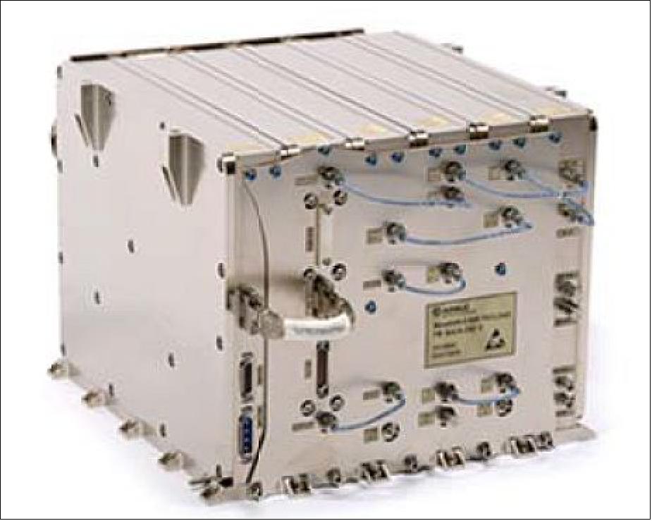
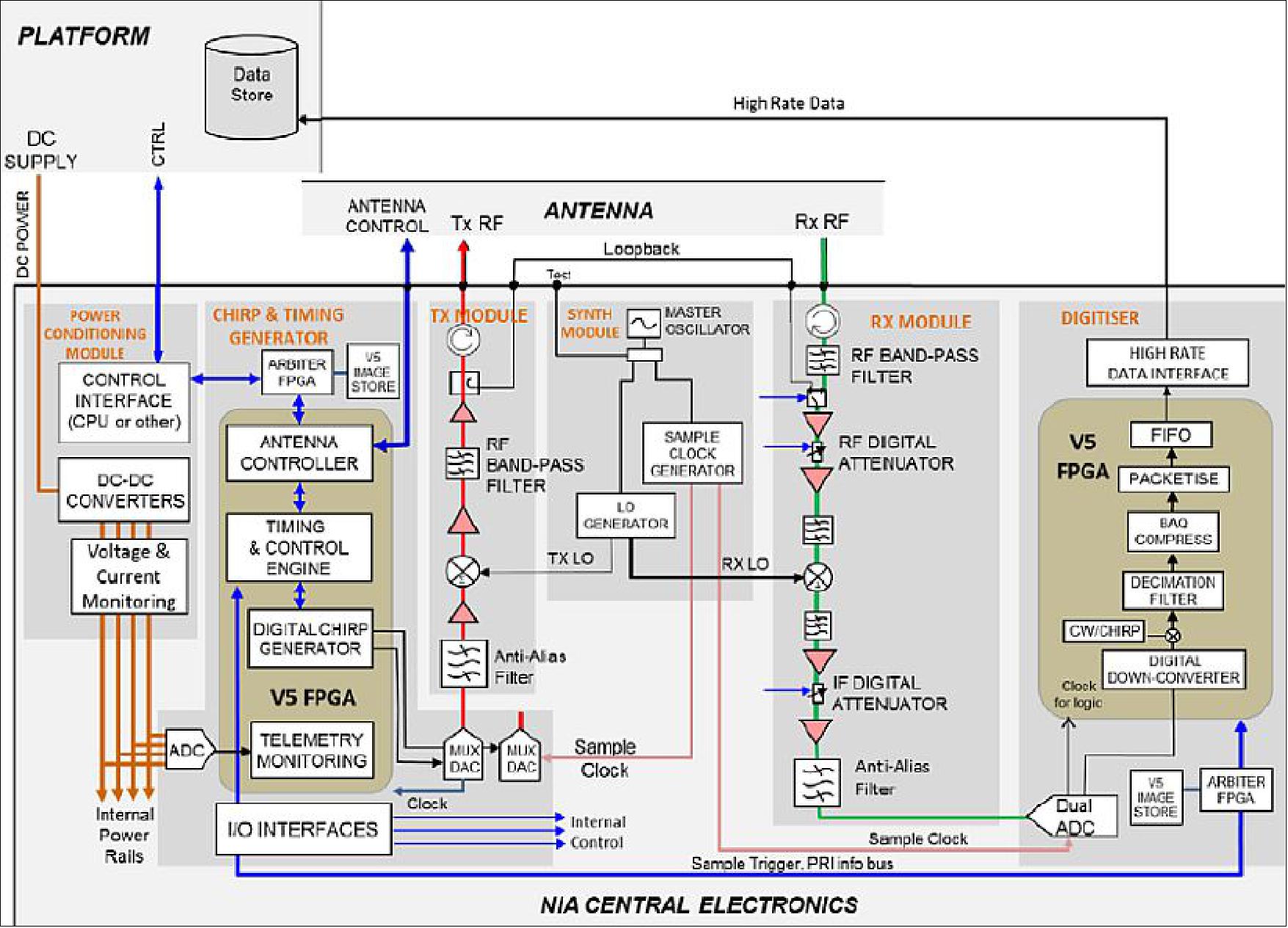
Backend (central electronics): A separate, but directly relevant, development at Airbus DS in Portsmouth is the NIA (New Instrument Architecture) generic space radar central electronics. This equipment exploits the power and flexibility of the Xilinx Virtex 5 (XQR5V) FPGA (Field Programmable Gate Array). The XQR5V is the first high performance RAM based FPGA to integrate effective single event effect mitigation into its core architecture. This has created the opportunity to develop a truly generic backend solution that can easily be applied to a very wide range of space radar missions with minimal non-recurring cost. In addition, the power of the Virtex 5 enables functionality that would normally be implemented within a dedicated CPU module within the central electronics to be moved into the FPGA, making the CPU module potentially unnecessary. Missions which are able to omit the CPU module from the central electronics not only save the mass, power, cost and size of the CPU module itself, but also have a fully functional equipment that requires no flight software, which is a major cost saving factor. NovaSAR-1 is an example of such a mission, and is fully functional without the need for a CPU module or any flight software. The NIA central electronics is compact, lightweight (10.9 kg on NovaSAR-1) and consumes just 46 W, the size of the instrument is 211 mm (H) x 265 mm (W) x 272 mm (D). NIA's first mission is NovaSAR-1. 38) 39) 40)
S-SAR Payload Qualification Campaigns
An extensive development program has been in progress for 3 years. This involves four stages of development for the NovaSAR-1 payload equipment:
1) Prototype hardware ground based inverse SAR test which imaged the ISS (International Space Station).
2) Airborne demonstrator using prototype hardware for providing sample imagery. 41)
3) In-orbit validation of payload technology by flying one phase center as a radar altimeter on the TechDemoSat-1 (Technology Demonstration Satellite-1) / TDS-1 mission of SSTL (a launch of TechDemoSat-1 is scheduled for late 2013).
4) Qualification of the payload via an EQM test campaign.
AIS (Automatic Identification System) Payload
AIS is a secondary payload on the NovaSAR-1 mission provided by COM DEV.
When the AIS instrument is being used to collect data simultaneously with SAR imagery of the same area, this will provide additional information on the identification of detected ships and highlight non-AIS transmitting vessels located in restricted areas. AIS is required to be carried for any ship over 300 tons, or for any passenger carrying ship, and the transmitted messages include unique identification, position, course, and speed data.
Note: The instrument will be described when information is available.
References
1) Philip Whittaker, Martin Cohen, David Hall, Luis Gomes, “An Affordable Small Satellite SAR Mission,” 8th IAA (International Academy of Astronautics) Symposium on Small Satellites for Earth Observation, Berlin, Germany, April 4-8, 2011; URL of the presentation, IAA-B8-0203, URL: http://media.dlr.de:8080
/erez4/erez?cmd=get&src=os/IAA/archiv8/Presentations/IAA-B8-0203.pdf
2) NovaSAR - setting a new benchmark in affordability and performance for spaceborne Synthetic Aperture Radar (SAR) systems,” SSTL, URL: https://web.archive.org/web/20141119153707/http://www.sstl.co.uk/Downloads/Datasheets/1767-SSTL-SAR-Datasheet
3) Philip Whittaker, Martin Cohen, David Hall, Rachel Bird, Luis Gomes, “NovaSAR – A Novel, Low Cost, Medium Resolution Spaceborne SAR System Development,” Proceedings of the 3rd Workshop on Advanced RF Sensors and Remote Sensing Instruments (ARSI), Noordwijk, The Netherlands, Sept. 13-15, 2011, URL: http://www.congrex.nl/11c11/ARSI%20papers/WHITTAKER_ARSI_Paper.pdf
4) Philip Whittaker, Rachel Bird, Martin Cohen, David Hall, Luis Gomes, Alex da Silva Curiel, Philip Davies, “A Low Cost SAR Solution for Disaster Management and Environmental Monitoring Applications,” Proceedings of IAC 2011 (62nd International Astronautical Congress), Cape Town, South Africa, Oct. 3-7, 2011, paper: IAC-11-B4.4.10
5) Philip Davies, Phil Whittaker, Rachel Bird, Luis Gomes, Ben Stern, Martin Sweeting, Martin Cohen, David Hall, “NovaSAR – Bringing Radar Capability to the Disaster Monitoring Constellation,” Proceedings of the 4S (Small Satellites Systems and Services) Symposium, Portoroz, Slovenia, June 4-8, 2012
6) Philip Davies, Alex da Silva Curiel, Rachel Bird, Philip Whittaker, Martin Cohen, David Hall, Luis Gomes, “Changing the Radar paradigm – Technology and cost trades in establishing the NovaSAR constellation,“ 6th International Conference 'Remote Sensing- the Synergy of High Technology,' Moscow, Russia, April 25-27, 2012,” URL: http://www.sovzondconference.ru/upload/
medialibrary/d77/d77b716f1e4a26f89bd6f786c68e0d0b.pdf
7) Philip Davies, Phil Whittaker, Rachel Bird, Luis Gomes, Ben Stern, Martin Sweeting, Martin Cohen, David Hall, “NovaSAR – Bringing Radar Capability to the Disaster Monitoring Constellation,” Proceedings of the 26th Annual AIAA/USU Conference on Small Satellites, Logan, Utah, USA, August 13-16, 2012, paper: SSC-I-7
8) Rachel Bird, Philip Whittaker, Ben Stern, Nil Angli, Martin Cohen, Raffaella Guida, “NovaSAR-1: A Low Cost Approach to SAR Applications,” URL: http://epubs.surrey.ac.uk/791379/1/PID2854845_NovaSAR_0052.pdf
9) ”NovaSAR-1 — the small satellite approach to Synthetic Aperture Radar,” SSTL brochure, URL: https://web.archive.org/web/20150910142109/http://www.sstl.co.uk/Downloads/Brochures/115184-SSTL-NovaSAR-Brochure-high-res-no-trims
10) David Beard, “Utility of NovaSAR for UK Maritime Surveillance Applications,” DMC Conference, London, UK, March 6-8, 2013, URL: http://www.spaceconference.co.uk/links/14/
Slides-Day2/David_Beard_DSTL_-_DMC_and_NovaSAR_Conference_-_7th_March_2013.pdf
11) “Government investment brings low cost radar satellites to market,” SSTL, Nov. 29, 2011, URL: https://www.sstl.co.uk/media-hub/latest-news/2011/government-investment-brings-low-cost-radar-satellites-to-market
12) “Government and industry to invest in world-leading UK satellite constellation,” Nov. 29, 2011, URL: http://www.bis.gov.uk/ukspaceagency/news-and-events/2011/Nov/
government-and-industry-to-invest-in-world-leading-uk-satellite-constellation
13) “UK and Japan commit to greater collaboration on space,” UKSA, April 18, 2012, URL: http://www.bis.gov.uk/ukspaceagency/news-and-events/
2012/Apr/uk-and-japan-commit-to-greater-collaboration-on-space
14) NovaSAR-1 the small satellite approach to Synthetic Aperture Radar, SSTL brochure, URL: https://web.archive.org/web/20150320114308/http://www.sstl.co.uk/Downloads/Brochures/2881-SSTL-NovaSAR-Brochure
15) Phil Davies, Andrew Cawthorne, Phil Whittaker, Sir Martin Sweeting, Martin Cohen, “Development and Test the First NovaSAR-1 Mission,” Proceedings of the 9th IAA Symposium on Small Satellites for Earth Observation, Berlin, Germany, April 8-12, 2013, paper: IAA-B9-1303
16) Tatsuo Shimizu, Craig Underwood, “Commercial Lithium‐Ion Capacitor for Spacecraft Energy Storage: Performance Characterization and Safety Evaluation,” Proceedings of the 9th European Space Power Conference, Saint Raphael, France, June 6-10, 2011, ESA SP-690
17) “SSTL Chairman Sir Martin Sweeting Takes A Gander @ 2015,” SSTL, January 12, 2015, URL: http://www.satnews.com/story.php?number=880392593
18) ”SSTL announces NovaSAR-1 and SSTL S1-4 will launch on ISRO's PSLV,” SSTL Press Release, 16 August 2018, URL: https://www.sstl.co.uk/media-hub/
latest-news/2018/sstl-announces-novasar-1-and-sstl-s1-4-will-launch
19) ”SSTL Announces NovaSAR-1 Data Deal with Australia’s CSIRO,” SSTL Press Release, 26 Sept. 2017, URL: https://www.sstl.co.uk/media-hub/latest-news/2017/sstl-announces-novasar-s-data-deal-with-australia-s-csiro#:~:text=Surrey%20Satellite%20Technology%20Limited%20(SSTL,a%20first%2Din%2Dclass%20small
20) PSLV-C42 Mission,” ISRO, 16 September 2018, URL: https://www.isro.gov.in/mission_PSLV_C42.html
21) ”SSTL confirms the successful launch of NovaSAR-1 and SSTL S1-4 satellites,” SSTL Press Release, 16 September 2018, URL: https://www.sstl.co.uk/media-hub/
latest-news/2018/sstl-confirms-the-successful-launch-of-novasar-1-a
22) ”CSIRO opens satellite offering for Aussie Earth observation,” CSIRO, 8 July 2021, URL: https://web.archive.org/web/20230311184154/https://www.csiro.au/en/news/News-releases/2021/CSIRO-opens-satellite-offering-for-Aussie-Earth-observation
23) ”SSTL signs up Space-Eyes for NovaSAR data,” SSTL Press Release, 27 April 2021, 13TH IAA Symposium on Small Satellites for Earth Observation, Berlin, URL: https://www.sstl.co.uk
/media-hub/latest-news/2021/sstl-signs-up-space-eyes-for-novasar-data
24) ”SSTL announces NovaSAR-1 data deal with the Philippines,” SSTL, 7 November 2019, URL: https://www.sstl.co.uk/media-hub/latest-news/2019/sstl-announces-novasar-1-data-deal-with-the-philip
25) Pejman Nejadi, Andrew Cawthorne, Kasia Clatworthy, Phil Whittaker, Alex da Silva Curiel, Martin Sweeting, Alex Held, Alvin E. Retamar, Rocell Nino B. Vicente, ”NovaSAR-1 - first year of an international partnership,” Proceedings of the 70th IAC (International Astronautical Congress), Washington DC, USA, 21-25 October 2019, paper: IAC-19-B1.1.10, URL: https://iafastro.directory/iac/
proceedings/IAC-19/IAC-19/B1/1/manuscripts/IAC-19,B1,1,10,x53177.pdf
26) Hirobumi Saito, Prilando Rizki Akbar, Hiromi Watanabe,Members,Vinay Ravindra, Jiro Hirokawa,Fellow, Kenji Ura,andPyne Budhaditya, ”Compact X-Band Synthetic Aperture Radar for 100 kg Class Satellite,” 4S Symposium, Valletta, Malta, 2016
27) Anthony Freeman, ”Design Principles for Smallsat SARs,” AIAA/USU Conference on small satellites, Logan UT August 2018, paper: SSC18-V-01, URL: https://pdfs.semanticscholar.org/0b82/83b23e1e507e17d24973a8dea412f0cbd4ab.pdf
28) Alex da Silva Curiel, Phil Whittaker, Rachel Bird, Andrew Haslehurst, Pejman Nejadi, Victoria Irwin, Andrew Cawthorne, Craig Underwood, Martin Sweeting, ”Synthetic Aperture Radar on a nanosatellite - is it possible?,” IAA Symposium on Small Satellites for Earth Observation, Berlin, May 2019, IAA-B2-1002, URL: http://epubs.surrey.ac.uk/852792/1/Synthetic%20Aperture%20Radar%20on%20a%20nanosatellite.pdf
29) Alex da Silva Curiel, Phil Whittaker, Glen Evans, Andrew Haslehurst, Andrew Cawthorne, Martin Sweeting, ”Business Under the Clouds,” Proceedings of the 33rd Annual AIAA/USU Conference on Small Satellites, August 3-8, 2019, Logan, UT, USA, paper: SSC19-XI-07, URL: https://digitalcommons.usu.edu/cgi/viewcontent.cgi?article=4449&context=smallsat
30) ”SSTL releases first images from S-Band Synthetic Aperture Radar satellite, NovaSAR-1,” SSTL Press Release, 23 November 2018, URL: https://www.sstl.co.uk/media-hub
/latest-news/2018/sstl-releases-first-images-from-s-band-synthetic-a
31) Martin Cohen, David Hall, Pedro Lau Semedo, ”NovaSAR-1 Low Cost SAR Payload,” Proceedings of EUSAR 2016, 11th European Conference on Synthetic Aperture Radar, Hamburg, Germany, June 6-9, 2016
32) Sam Doody, Martin Cohen, José Marquez-Martinez, ”Next Generation Low Cost Space SAR Developments,” Proceedings of EUSAR 2016, 11th European Conference on Synthetic Aperture Radar, Hamburg, Germany, June 6-9, 2016
33) M. A. B. Cohen, P. Lau Semedo, C. D. Hall, “Low Cost S-Band SAR Payload for the NovaSAR-1 Mission,” Proceedings of the Advanced RF Sensors and Remote Sensing Instruments &Ka-band Earth Observation Radar Missions, (ARSI'14 & KEO'14), ESA/ESTEC, Noordwijk, The Netherlands, Nov. 4-7, 2014
34) “NovaSAR-1 Mission and Imaging Overview,” Annual Conference of the Remote Sensing and Photogrammetry Society 2012, University of Greenwich, London, UK, Sept. 13-14, 2012, URL: http://www.eotechcluster.org.uk/eotechcluster/documents/novasar-overview-for-rspsoc-sep12.pdf
35) Matt O’Donnell, “ASAR to NovaSAR–the Industrial Story,” NCEO/CEOI (National Centre for Earth Observation/Centre for Earth Observation Instrumentation) Joint Science Conference, Nottingham, UK, Sept 18-20, 2012, URL: http://www.nceo.ac.uk/assets/presentations/
2012_conference_NOTTINGHAM/NCEOCONF2012_0919_ODonnell.pdf
36) Geoff Burbridge, David Hall, “Astrium S-band airborne demonstrator opportunity,” Earth Observation Technology Cluster, UK, Sept. 13, 2012, URL: http://www.nottingham.ac.uk/
eotechcluster/documents/astrium-s-band-airborne-demonstrator-opportunity-final-v2.pdf
37) Pasquale Iervolino, Raffaella Guida, Philip Whittaker, “NovaSAR-1 and Martime Surveillance,” Proceedings of IGARSS (IEEE International Geoscience and Remote Sensing Symposium), Melbourne, Australia, July 21-26, 2013
38) M. A. B. Cohen, D.C. Lancashire, A. Larkins, P. Watson, P. Lau Semedo, “NIA Generic Radar Central Electronics Product,” Proceedings of the Advanced RF Sensors and Remote Sensing Instruments &Ka-band Earth Observation Radar Missions, (ARSI'14 & KEO'14), ESA/ESTEC, Noordwijk, The Netherlands, Nov. 4-7, 2014
39) Martin Cohen, Andrew Larkins, Phil Wason, ”NIA SAR Central Electronics Product,” Proceedings of EUSAR 2016, 11th European Conference on Synthetic Aperture Radar, Hamburg, Germany, June 6-9, 2016
40) José Márquez-Martínez, Martin Cohen, Sam Doody, Pedro Lau-Semedo, Andrew Larkins, ”Next Generation Low Cost Payloads: NovaSAR-1 and beyond,” Proceedings of IGARSS 2017 (IEEE International Geoscience and Remote Sensing Symposium), Fort Worth, Texas, USA, July 23–28, 2017
41) Antonio Natale, Raffaella Guida, Rachel Bird, Philip Whittaker, Martin Cohen, David Hall, “Demonstration and Analysis of the Applications of S-Band SAR,” APSAR (The Asia-Pacific Conference on Synthetic Aperture Radar), Seoul, Korea, Sept. 26-30, 2011, URL: http://epubs.surrey.ac.uk/726887/2/PID1983553.pdf
Spacecraft Launch Mission Status Sensor Complement References Back to top