Okean-O1 (Ocean-O1)
EO
Atmosphere
Ocean
Liquid water and precipitation rate
Quick facts
Overview
| Mission type | EO |
| Agency | ROSKOSMOS, ROSHYDROMET |
| Mission status | Mission complete |
| Launch date | 11 Oct 1994 |
| End of life date | 01 Jan 1996 |
| Measurement domain | Atmosphere, Ocean, Land, Snow & Ice |
| Measurement category | Liquid water and precipitation rate, Cloud particle properties and profile, Multi-purpose imagery (ocean), Radiation budget, Multi-purpose imagery (land), Albedo and reflectance, Atmospheric Humidity Fields, Ocean topography/currents, Sea ice cover, edge and thickness, Snow cover, edge and depth, Ocean surface winds, Ocean wave height and spectrum, Ice sheet topography |
| Measurement detailed | Ocean imagery and water leaving spectral radiance, Precipitation intensity at the surface (liquid or solid), Cloud liquid water (column/profile), Land surface imagery, Earth surface albedo, Short-wave Earth surface bi-directional reflectance, Atmospheric specific humidity (column/profile), Wind vector over sea surface (horizontal), Sea-ice cover, Snow cover, Sea-ice thickness, Significant wave height, Ocean dynamic topography, Sea-ice sheet topography |
| Instruments | RLSBO, KONDOR-2, MSU-M, MSU-S, RM-08 |
| Instrument type | Imaging multi-spectral radiometers (vis/IR), Imaging multi-spectral radiometers (passive microwave), Data collection, Imaging microwave radars |
| CEOS EO Handbook | See Okean-O1 (Ocean-O1) summary |
Okean-O1
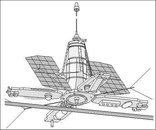
The Okean-O1 (Ocean-O1) is a spacecraft generation, built by the Yuzhnoye Design Office (Research and Production Association) of Dnepropetrosvk, Ukraine. The spacecraft is intended for an operational and all-weather monitoring service (optical, active and passive microwave regions), providing data on the ocean surface conditions and on natural resources for Russian institutions. 1)
Spacecraft
The S/C bus is a three-segmented, vertically oriented cylinder, 3 m tall with a base diameter of 1.4 m and an upper diameter of 0.8 m. Okean's primary structure is pressurized and maintained at normal temperatures to protect the support system and payload electronics housed within. Two small, rotatable solar arrays (1.6 m x 2.0 m) provide a modest 110 - 270 W average daily power to the payload. The S/C is three-axis stabilized (nadir pointing), stabilization is also partially provided by a gravity-gradient boom extended from the top of the satellite. At the bottom, four large panels (1.0 m x 2.9 m), attached at 90º intervals, support a number of payload receivers and transmitters. A narrow, 11 m long radar antenna is fixed to the base of one panel.
The overall S/C mass is about 1950 kg with a payload capacity of 550 kg. The operational design life is 2 years.
S/C Name | Launch Date | Remarks | Instrument complement |
Okean-O1-N1 (Cosmos 1766) | July 29, 1986 | operational until 1988 | RLSBO (3.2 cm), RM-0.8, MWP (3.2 cm), RTVK, MSU-SK, Kondor |
Okean-O1-N2 (Cosmos 1869) | July 16,, 1987 | operational until 1989 | RLSBO (3.2 cm), RM-0.8, MWP (3.2 cm), RTVK, MSU-SK, Kondor (RLSBO did not work) |
Okean-O1-N3 | July 5, 1988 | operational until 1990 | RLSBO (3.2 cm), RM-0.8, MWP (3.2 cm), RTVK, MSU-SK, Trasser, Kondor |
Okean-O1-N4 | June 9, 1989 | launch failure | RLSBO (3.2 cm), RM-0.8, MWP (3.2 cm), RTVK, MSU-SK, Kondor |
Okean-O1-N5 | Feb. 28, 1990 | operational until 1991 | RLSBO (3.2 cm), RM-0.8, MWP (3.2 cm), RTVK, MSU-SK, Kondor |
Okean-O1-N6 | June 4, 1991 | operational until 1993 | RLSBO (3.2 cm), RM-0.8, MWP (3.2 cm), RTVK, MSU-SK, Kondor |
Okean-O1-N7 | Oct. 11, 1994 | operational until 1, 1996 | RLSBO (3.2 cm), RM-0.8, MWP (3.2 cm), RTVK, MSU-SK, Kondor |
Okean-O1-N8 | Aug. 31, 1995 | operational until 1996, Russian/Ukrainian joint venture | RLSBO (3.2 cm), RM-0.8, MWP (3.2 cm), RTVK, MSU-SK, Kondor |
Okean-O1-N9, Sich-1M (modified) | Dec. 24, 2004, Plesetsk | Sich-1M did not achieve its nominal orbit | RLSBO, RM-08, MSU-M, MSU-EU1 & -EU2, MTVZA-OK, Variant |
Orbit: Near-circular polar orbit, altitude range of 650 km, inclination 82.5º, period = 98 minutes.
RF communications: One of the features of Okean type satellites is the capability of direct data reception by various users having only simple hardware and software for data processing (APT type data reception). The downlink frequency of 137.4 MHz (carrier frequency with 2.4 kHz subcarrier frequency) is used for direct broadcasts of RLSBO and MSU-M imagery with reduced resolution to any of the CIS APT stations as well as to foreign users. The second science data downlink has a carrier frequency of 466.5 MHz.
Data collected are being transmitted to receiving stations at Moscow, Novosibirsk, and Khabarovsk (Pacific region). Maps can be readied in 10 days and ice forecasts sent directly to ships at sea.
Sensor Complement
RLSBO (Side Looking Real Aperture Radar)
RLSBO (Kharkov IRE, Ukraine, PI: Kalmykov) is the prime sensor of the Okean series (11.1 m antenna length). Wavelength/frequency: 32 mm/9.7 GHz (X-band); resolution = 2.1 - 2.8 km in flight direction, = 1.2 - 0.7 km in cross track direction; swath width = 450 km. 2)
- impulse duration = 3 µs
- impulse peak power = 100 kW
- pulse repeat frequency (ORF) = 100 Hz
- polarization = V (vertical)
RM-08 (Passive Microwave Scanning Radiometer)
RM-08 was developed at Kharkov IRE, Ukraine. Wavelength/frequency: 0.8 cm / 36.6 GHz; resolution = 15 km x 20 km, swath width = 550 km. Objective: monitoring of atmospheric water vapor, sea ice, and ocean surface temperature with an accuracy of 1 - 2 K.
MSU-M (Multispectral Scanner)
MSU-M is a low resolution instrument developed at ISDE (Institute of Space Device Engineering), Moscow. Resolution = 1.0 km x 1.7 km, swath width = 1900 km. Objective: cloud monitoring and sea surface temperature. Spectral ranges: 0.5 - 0.6 µm; 0.6 - 0.7 µm; 0.7 - 0.8 µm; 0.8 - 1.1 µm.
MSU-S (Multispectral Scanner)
MSU-S is a moderate resolution developed at ISDE, Moscow. Two spectral ranges: 0.6 - 0.7 µm, 0.7 - 0.9 µm; resolution = 250 m; swath width = 1100 km.
Kondor
Kondor is an onboard data collection system to gather data from DCPs (Data Collection Platforms) from the ground segment.
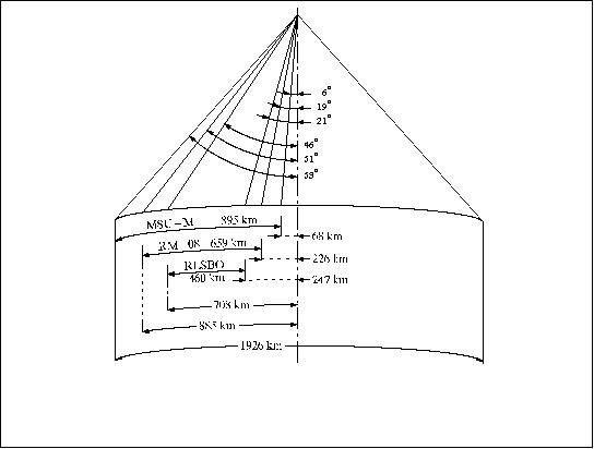
Figure 2: Observation geometries for Okean-O1 instruments (shown to one side only)
References
1) http://eng.ntsomz.ru/spacecraft/okean_o1
2) V. V. Asmus, O. Y. Milekhin, V. A. Krovotyntsev, A. S. Selivanov, “Use of Radar Data From Okean-series Satellites in Hydrometeorology and Environmental Monitoring,” Ingenta, ISSN 0749-3878, `Mapping Sciences & Remote Sensing,' Vol. 40, No 1, 1 January 2003, pp. 17-28 (12)
The information compiled and edited in this article was provided by Herbert J. Kramer from his documentation of: ”Observation of the Earth and Its Environment: Survey of Missions and Sensors” (Springer Verlag) as well as many other sources after the publication of the 4th edition in 2002. - Comments and corrections to this article are always welcome for further updates (eoportal@symbios.space).