OptiSAR (Optical and SAR) Commercial Constellation of UrtheCast
EO
Urthecast
-
Once expected to launch in 2023, OptiSAR (Optical Synthetic Aperture Radar) was a constellation of eight identical optical imaging and eight identical SAR satellites being developed by UrtheCast. The Canadian Earth observation company became bankrupt in 2021 hence the commercial mission never launched.
Quick facts
Overview
| Mission type | EO |
| Agency | Urthecast |
| Mission status | - |
| Launch date | 31 Dec 2023 |
| CEOS EO Handbook | See OptiSAR (Optical and SAR) Commercial Constellation of UrtheCast summary |
Summary
Mission Capabilities
All the optical satellites would have carried two instruments; a high-resolution camera (HRC), and a meteorological camera named MetCam. MetCam provides the data to complete atmospheric corrections on the SAR data. All the SAR satellites would have carried two instruments; a dual frequency X-band and L-band SAR, and an AIS (Automatic Identification System) receiver. The AIS allows the imaging instruments to pinpoint areas of maritime interest.
The instruments together have a variety of applications including maritime surveillance, oil spill tracking, decoy detection, and port monitoring. The choice of imager would depend on weather, visibility, penetration ability, and required spatial resolution.
Performance Specifications
The HCM is a pushbroom imager with a spatial resolution of 0.25 m for still images and a resolution of 0.4 m for film captured at 30 frames per second. MetCam observes with a spatial resolution of 0.5 m. The dual frequency SAR has a minimum spatial resolution of 1 m for X-band, and 5 m for L-band. The SAR also has four observation modes: spotlight mode, multi-aperture stripmap mode, dual-band stripmap mode, and scanSAR mode; with swath widths of 10 km x 5 km (X-band), 7.5 km (X-band), 10 km (X-band) and 7.5 km (L-band), and 140 km (L-band), respectively.
The satellites were planned to operate in one of two orbital planes, with eight satellites in tandem in each plane. Each pair would consist of a leading SAR satellite and an optical satellite following approximately 2 minutes behind. Both orbits are sun-synchronous with an altitude of 450 km, but one has an inclination of 98°, and the other, 45°.
Space and Hardware Components
The optical imaging satellites were 700 kg each, whilst the SAR satellites are 1800 kg each.
Payload data would have been transferred via X-band radio frequencies at a rate of 1600 Mbit/s.
EarthDaily Analytics (EDA) was a company that was erected in 2021 after buying several parts of UrtheCast prior to it becoming bankrupt. Expected to launch in 2023, EDA is launching the EarthDaily constellation which has similar capabilities to OptiSAR.
OptiSAR (Optical and SAR) Commercial Constellation of UrtheCast
The Constellation The Original 'New Space' Way References
In June 2015, UrtheCast, the Vancouver-based technology company, announced plans to build, launch and operate the world's first fully-integrated, multispectral optical and SAR (Synthetic Aperture Radar) commercial constellation of Earth Observation satellites (known as the OptiSAR™ Constellation), to be deployed over multiple launches in 2019 and 2020. 1) 2)
The Constellation is expected to comprise a minimum of 16 satellites (8 optical and 8 SAR) flying in two orbital planes, with each plane consisting of four satellite pairs, equally-spaced around the orbit plane. Each pair of satellites will consist of a dual-mode, high-resolution optical satellite (video and pushbroom) and a dual-band high-resolution SAR satellite (X-band and L-band) flying in tandem.
The Constellation will provide what the Company anticipates to be unmatched space-imaging capabilities, including high collection capacity, optical and SAR data fusion, weather-independent high-resolution imaging using the SAR, target revisit, and imaging latency. By flying the satellites in tightly-paired SAR and optical tandem formations, the Constellation is expected to offer a number of innovative capabilities, including onboard real-time processing, cross-cueing between the satellites, and real-time cloud imaging on the leading SAR satellites that enables cloud avoidance in the trailing optical satellites. By employing two orbital planes, the Constellation will allow for maximum revisit rates in the mid-latitudes, while providing the Company with global coverage extending to the poles.
Some background
UrtheCast, although a relatively new name in the industry, has already emerged as a key player in the downstream space industry. The company's novel vision to democratize Earth observation has, in part, been achieved by establishing several sovereign space capabilities in a relatively short period. This includes the Generation 1 cameras that were docked onto the ISS in 2013 that has been producing ultra high definition videos (via the Iris instrument) and medium resolution imagery (via the Theia instrument). Without the usual power, mass and thermal constraints of a standalone spacecraft, the use of the ISS dramatically changes the economics of Earth observation from space. In addition to this, the recently acquired Deimos Imaging by the company comes with the added benefit of the use of the fully operational medium resolution Deimos-1 and high resolution Deimos-2 satellites.
The next piece of the company's grand vision is the recently announced OptiSAR Constellation mission; a 16-satellite state-of-the-art constellation of SAR and Optical satellites, built and tested in partnership with SSTL, UK. The combination of SAR and Optical satellites forms a constellation whose performance and functionality is unparalleled in the Earth observation domain.
• In Nov. 2015, UrtheCast announced it is refocusing its investment away from International Space Station-mounted cameras toward a planned constellation of Earth-imaging satellites. UrtheCast had been investing in a second-generation camera system for the space station, but has shifted focus to prepare for a 16-satellite constellation of eight optical and eight SAR (Synthetic Aperture Radar) satellites in LEO (Low Earth Orbit), all to be built by small-satellite specialist SSTL (Surrey Satellite Technology Ltd.),UK. 3)
- The second-generation camera system for the space station — a dual-mode camera plus a synthetic aperture radar — will now be put on hold to support development of the constellation.
- The high-resolution Iris video camera's pointing platform — provided by UrtheCast partner RSC Energia of Kaliningrad, Russia — was defective and required new cabling and a software patch.
• Geospatial imaging services provider UrtheCast Corp. of Canada on March 30, 2016 gave investors an in-depth look at the company's strategy, including a new eight-satellite constellation addition to the 16-satellite system announced in November 2015. 4)
- UrtheCast declined to say when its OptiSAR constellation of eight optical and eight two-band radar satellites would be built, insisting that the company would not seek funding from the capital markets but would wait for prospective customers to commit the needed resources.
- The same is true for the newly disclosed UrtheDaily constellation of eight medium-resolution optical satellites. To be built by the same Surrey Satellite Technology Ltd.-based team that will build OptiSAR, UrtheDaily will not happen without firm customer commitments, the company said.
- "The trigger is when we've signed up enough customers whose contractual demand is enough for us to finance against it," UrtheCast Chief Executive Wade Larson said, adding that the company's business model borrows more from established geospatial imagery provider DigitalGlobe of Westminster, Colorado, than from Google's Skybox Imaging, recently renamed Terra Bella, of Mountain View, California.
- UrtheCast, following its July 2015 purchase of Deimos Imaging of Spain, operates four optical sensors. The medium-resolution Deimos-1 satellite and a medium-resolution Theia camera mounted on the Russian side of the international space station offer wide-area coverage. The high-resolution Deimos-2 satellite provides sharper imagery but of smaller areas and for sales purposes is often bundled with UrtheCast's high-resolution Iris video camera, also on board the space station.
• April 4, 2016: UrtheCast announced the establishment of a Cooperative Research and Development Agreement (CRADA) with the U.S. NGA (National Geospatial-Intelligence Agency). 5)
• May 2, 2016: UrtheCast announced that it has successfully completed prototype hardware testing of the principal core enabling elements of our ground-breaking SAR (Synthetic Aperture Radar) technology. This includes the digital sensor electronics, which is the "heart" of the SAR instrument, and the dual-frequency, multi-aperture SAR antenna in which the X- and L-bands share the same aperture. 6)
- Working in close conjunction with strategic partners, UrtheCast has built two multi-channel DRFUs (Digital Radio Frequency Units) and completed thorough testing of the core functions at ultra-high data rates that are fully representative of the flight system. This included tests to demonstrate the ability to synchronize two DRFUs at the Tbit/s data rates required to enable the multi-aperture operation of the SAR antenna. The tests have demonstrated a 150 femtosecond sampling accuracy (i.e., 150 x 10-15 s), critical for achieving the unprecedented multi-aperture performance capability of UrtheCast's SAR technology. The Company has also built and tested a panel of its dual-frequency, multi-aperture antenna using flight representative manufacturing processes that have successfully demonstrated the antenna's RF performance in both the X- and L -band frequencies and in both transmit and receive modes. In addition, the tests confirmed the exceptionally high efficiency of the antenna system.
- UrtheCast's SAR technology allows for unprecedented performance and imaging flexibility, providing high resolution, wide swath, simultaneous dual X- and L- band, and multi-aperture imaging capability with improved suppression of ambiguities — and all at much lower cost than the currently operating state-of-the-art SAR systems. This new SAR technology is being developed as part of the company's previously announced OptiSAR™ Constellation. By capturing SAR and optical data in unison, the Constellation is expected to offer uniquely information-rich EO (Earth Observation) imagery and derived information products, serving not only traditional EO markets but also rapidly-growing markets in geoanalytics.
- "We believe that UrtheCast's SAR is the world's most sophisticated imaging radar in commercial development," said UrtheCast's CTO, George Tyc. "It has been developed through numerous innovations and has resulted in the filing of multiple patent applications." Now that it has been demonstrated using flight representative parts and processes, and the tests have shown that it works spectacularly well, the technical and programmatic risks of our OptiSAR™ Constellation development program have been massively reduced. In short, UrtheCast's low-cost revolutionary SAR technology can now be considered proven. It's a game changer."
• May 26, 2016: UrtheCast Corp. announced that it will receive $5.0 million in Government of Canada TDP (Technology Development Program) funding, as part of a $54 million contribution program for the development of new satellite technologies, as administered by the Government of Canada. 7)
- This TDP Agreement will aid UrtheCast in the development of the ground-breaking technologies for its planned OptiSAR™ Constellation, currently slated for deployment in 2020-2021. The 16-satellite OptiSAR™ Constellation is expected to consist of eight X- and L-band SAR satellites and eight high-resolution optical satellites, flying in a paired, tandem configuration.
• January 17, 2017: UrtheCast Corp. announced that it has entered into a binding agreement with a confidential government customer for the sale and shared operation of the first two satellites in the OptiSARTM Constellation, the world's first commercial EO constellation with integrated optical and Synthetic Aperture Radar (SAR) sensors, for US$180 million. The customer has also agreed to pay an additional US$30 million for other products and services related to the sale of the satellites, contingent on the parties reaching mutual agreement on the final scope of these deliverables. 8)
- "This milestone in the OptiSARTM program is the result of years of technology development and many months of contract negotiations," explained UrtheCast's President and Chief Executive Officer, Wade Larson. "Not only is this a strong endorsement of the OptiSARTM Constellation and evidence of the commercial demand for this technology, but we believe this contract will accelerate the negotiation of similar agreements with other customers for the purchase of the remaining satellites."
- In June 2015, UrtheCast first announced its plans to build, launch and operate the OptiSARTM Constellation, which is expected to comprise 16 satellites in total (eight optical and eight SAR) flying in two orbital planes, with each plane consisting of four satellite pairs. Each pair will fly in tandem and consist of a high-resolution optical satellite offering video and pushbroom imaging and a dual-band, high-resolution SAR satellite comprised of X and L radar bands. By employing two orbital planes, the OptiSARTM Constellation can provide for maximum revisit rates in the mid-latitudes, while providing global coverage extending to the poles. Subject to UrtheCast financing the build and launch of the remaining six satellites in the first orbital plane, the first eight satellites are scheduled for launch in late 2021, with operations expected to begin in 2022.
This Isn't Just Another Constellation!
The ‘New Space' phase has been at an all-time high. The past few years have seen a significant rise in announcements of "game changing" constellations in the Earth observation, science and telecommunications domain. So is this mission truly unique or is it just another cool idea? The UrtheCast Constellation is the world's first combined SAR and Optical commercial constellation. The goal of the mission is to collect data that can be processed into very high resolution, 0.5 m class still and video Optical imagery, and high resolution L-band and X-band SAR products. The SAR sensor incorporates a patented technology that gives it the ability to image simultaneously in quad-polarization L-band and single-polarization X-band from the same sensor.
These products will serve a variety of end users and markets such as traditional Earth observation commercial and civil applications, data analytics and ‘big data' applications, and the nascent social media and consumer applications. The individual performance of each satellite, as described in the coming sections, speaks for itself, however, the other aspect that differentiates this constellation from the rest is its innovative concept of operations. This will also be detailed in the coming sections.
Dual-Mode Optical Camera
The Optical satellites within the constellation include of a range of sensor suites – the dual-mode camera, the meteorological camera and the AIS (Automatic Identification System) receivers. The dual-mode camera can be operated either in pushbroom or in video mode.
The pushbroom sensor uses a 64-stage TDI (Time Delayed Integration) architecture, digitized to 14 bits. This sensor yields a nominal 12.29 km swath (at nadir for 450 km altitude) and is comprised of a panchromatic channel giving 0.5 m class imagery and six multispectral channels giving 2 m class imagery: blue, green, yellow, red, red-edge and NIR (Near-Infrared). The video sensor uses a 20 Mpixel CMOS detector that yields a nominal footprint of 2.5 km x 1.9 km (at nadir for 450 km altitude) at up to 30 FPS (Frames Per Second), digitized to 12 bits. This detector uses a Bayer filter that provides three spectral channels (red, blue and green) giving 0.5 m-class imagery.
Augmenting the dual-mode Optical camera is a meteorological camera (MetCam), providing additional spectral channels, albeit at a lower resolution, designed to measure the impact of the atmosphere on the imagery and enable its correction during ground image processing. The data from the MetCam is not included in the distributed product though.
Complementing the leading SAR payload are the AIS receivers which, when combined with processed SAR data, provide useful information on potential targets of interest in the maritime regions, for the Optical satellite to then investigate further.
Dual-band SAR (Synthetic Aperture Radar)
The SAR satellites within the constellation include a pair of sensor suites – the dual-band SAR and the cloud camera. The dual-band, L- and X-band, SAR can be operated in one of two modes: StripMap and ScanSAR.
• The StripMap mode is able to acquire 2 m-class (X-band) and 10 m-class (L-band) imagery with a nominal swath width of 10 km.
• The ScanSAR mode is able to acquire 10 m-class (X-band) and 30 m-class (L-band) imagery with a nominal swath width of 25 km when both bands are operated together. When operating L-band alone, the ScanSAR mode is able to acquire 30 m-class imagery with a swath width of up to 100 km.
The L-band SAR supports the full complement of polarization options, including single, dual, quad, linear-compact and circular compact pole. The X-band SAR supports VV polarization only. - The SAR data can also be used to generate interferometric products.
Adding to the SAR payload is a cloud camera (CloudCam), providing continuous cloud coverage to assist the trailing Optical satellite with its image acquisition campaign. The rationale for this is described in the following section.
Novel Concept of Operations
Traditionally, the power hungry nature of SAR sensors combined with their day and night imaging ability have driven SAR satellites to fly in dawn-dusk orbits to maximize power generation and the payload duty cycle. This, however, hasn't been the case for Optical satellites due to the less than optimal ground illumination conditions in such orbits. For the Constellation, the tandem formation of both types of spacecraft drives the local solar time of the sun synchronous plane to that more suited for an Optical satellite. However, it is this combination of SAR and Optical satellites that forms a constellation whose performance and functionality is unparalleled in the Earth observation domain. This is a result of each SAR-Optical satellite pair in the constellation being able to uniquely interact with each other in real-time to optimize and enhance the data acquired by the Constellation.
Studies have shown that approximately 67% of the Earth's surface is typically covered by clouds, with only 30% of land usually cloud-free. With Optical satellites frequently being susceptible to acquiring cloudy images, it is important to manage on-board resources effectively, to maximize the amount of useful imagery acquired and increase revenue potential. As clouds can't be moved and it is both difficult and expensive to provide the satellites with real-time cloud coverage from the ground, why not just avoid them autonomously? As detailed in the previous section, each of the leading SAR satellites will have the ability to take real-time cloud imagery via the CloudCam. A continuous stream of cloud maps will be sent over to the trailing Optical satellites, which will then process the data on-board to determine which cloud-free areas of interest it can image to optimize its image acquisition campaign.
The cross-cueing capability of the Constellation provides another completely unique level of service, where the SAR satellite can operate in a wide-area surveillance mode (using ScanSAR) and be used in combination with the on-board cloud camera to determine if a target of interest (TOI) appears that can be imaged by the trailing Optical satellite. If so, the SAR satellite can immediately send the position of the TOI to the Optical satellite, which then correlates this target with the AIS data it is receiving from its on-board AIS receivers, to then re-task itself to maneuver to take a very high resolution image of the target within minutes of the detection.
These are just a few of the unique operation concepts that illustrate the rationale of this tandem formation and the potential of the mission.
What You Get From the Constellation
A combination of the state-of-the-art sensors onboard each satellite in the Constellation and the innovative concept of operations generates unique and useful datasets of which a wide range of information can be extracted from.
The Constellation will generate an industry standard set of RPC (Rapid Positioning Capability) Model and OM (Ortho Model) products and videos. These products will include the imagery (all Optical sensor spectral channels and all SAR sensor polarizations) and the associated metadata for both sensors.
One of the main advantages of the Constellation is the ability to fuse SAR and Optical data. The SAR and Optical data are highly complementary in terms of the information that can be extracted from each source.
The polarization and dielectric measurement provided by SAR data can support determination of material classification, wetness, structure, texture and roughness information about the scene that the Optical data often cannot. For example, agriculture and forestry applications based on Optical data need to include a correction for soil moisture. And the SAR data can also assist in differentiating plant and tree types based on their polarization information. The SAR interferometric products can also be used to measure minute variations in the Earth's surface.
The spectral measurement provided by Optical data can support determination of signature classification information about the scene that SAR data often cannot. For example, the spectral signatures of different types of man-made objects, vegetation and geologic features are all well characterized in Optical data, and less so in SAR data. - The addition of a time-series of images acquired by the video sensor over the arc of acquisition geometries yields an even deeper understanding of the scene due to the 3D surface model and motion vector information that it provides.
Consequently, the fusion of Optical imagery, SAR imagery and interferometric information, 3D surface model and motion vector products yields a suite of products where there is significantly more information that can be extracted from any individual data source alone.
With co-incident Optical and SAR imagery, 3D surface model and motion vector information, the accuracy and range of possible applications becomes even more interesting because it eliminates a variety of unaccountable sources of error, typical of most fusion products resulting from the misregistration due to weather conditions, solar illuminations, temporal scene changes, viewing geometries, etc.
For example, in forestry biomass estimation, the X-band SAR sensor is used to locate the tops of the trees and the L-band SAR sensor is used to locate the bottom of the tree, thus yielding an accurate stand height. The pushbroom sensor is used to perform spectral classification to determine tree species and stand density. The video sensor is used to construct a 3D surface model of the scene and correct for any errors in the intermediate results. The data is then fused, in conjunction with the appropriate forestry models, in order to estimate the biomass.
The processing of high resolution SAR data will benefit greatly from being fused with accurate 3D surface models and motion vector information, thus yielding accurately focused imagery. SAR data has been traditionally processed assuming a smooth Earth or a coarse DEM, and therefore tends to be somewhat out of focus and suffer from layover and shadow artefacts. Since SAR data relies on the Doppler phase history, objects that are moving are therefore mislocated.
The cyclic nature of the solar illumination variations from the medium inclined orbit will allow construction of shadow-free 3D image models of cities by fusing both Optical and SAR data acquired over several orbits, giving both color and structural information for all surfaces.
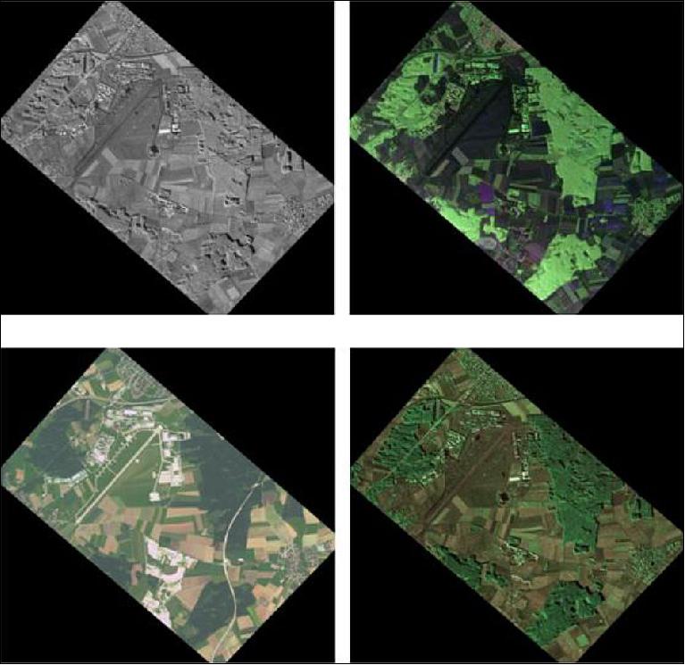
The images of Figure 2 illustrate a simple example of multi-sensor data fusion, combining X-band SAR, L-band SAR and multispectral Optical imagery, resulting in a very content-rich information product.
At the End of the Day, it's About the Applications!
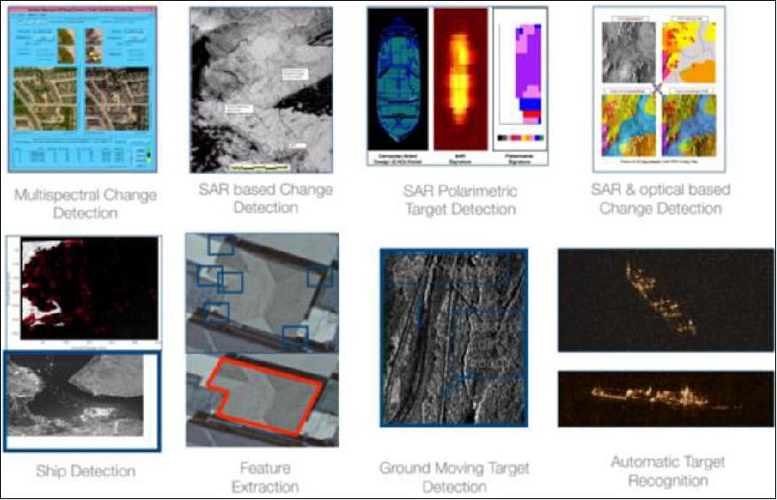
The standard and fusion products discussed earlier will feed into applications and services such as data analytics, site monitoring and wide-area reconnaissance.
The unique combination of the multispectral Optical data and the X-band and full quad-pole L-band SAR data provides for many unique applications. As described in the previous section, the L-band SAR data has the unique ability to penetrate through the forest canopy to measure biomass, for example, and detect objects under trees, while the X-band SAR reflect from the top of the canopy to support the biomass estimates and provides higher resolution. When combined with the multispectral Optical data, this provides for information rich fusion products.
As another example, in the rapidly growing area of ‘big data' analytics, the dual-band SAR data on its own can provide very high value due to its ability to provide imagery independent of clouds and also at night. When combined with optical data (when it is available on cloud free days), this can provide powerful information that feeds the ‘big data' analytics engines to create many different types of information products.
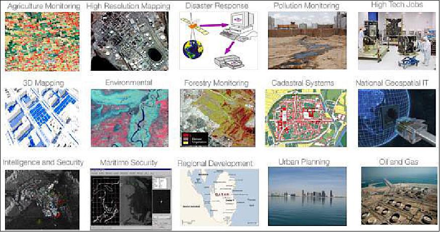
The Constellation will also serve as a platform for advancing the research and development of a host of new applications and services. The combination of on-board processing capability, flexible and highly-configurable Optical and SAR sensor acquisition modes, and rapid data delivery will be used to support experiments involving novel acquisition geometries and imagery exploitation, and reducing latency in the delivery of actionable information to end users.
Just a small subset of the potential application areas that are currently being explored are:
• Maritime Surveillance: The SAR and Optical sensors could be used in a cross-cueing scenario. The leading SAR sensor would scan the ocean, the on-board processor would perform real-time ship detection and the leading Optical sensor would be commanded to acquire very high resolution images of selected ships for positive identification and detection of any pollution discharges. Only the OTH-Gold (Over-The-Horizon) messages, together with their corresponding image chips from both the SAR and Optical sensor, would then need to be downlinked with no additional ground processing required.
• Oil Spill Tracking: The X-band SAR provides superior oil-to-sea contrast. The fully polarimetric L-band SAR combined with Optical data provides oil classification in terms of its makeup (plant or mineral) and thickness.
• Camouflage Detection: The penetration capabilities of the SAR sensor would be exploited to detect vehicles or other man-made structures hidden beneath natural or artificial foliage. When the Optical sensor fails to detect the same vehicles or structures, this indicates a likely camouflage situation.
• Decoy Detection: The material classification capabilities of the SAR sensor would be exploited to differentiate real vehicles from wood, paper or plastic decoys that can easily fool an Optical sensor.
• Disturbed Earth Detection: The penetration capabilities of the SAR sensor would be exploited to detect changes to the soil. When the Optical sensor fails to detect the same disturbances, this indicates a likely recent change.
• Port Monitoring: The SAR and Optical sensors would be used to count shipping containers and determine stockpile volumes.
• Car Counting: The SAR sensor would be used to count parked vehicles located around factories, shopping malls, gathering places and transportation hubs. The medium inclined orbit would be exploited to yield car counts at constantly changing times of day, enabling monitoring of worker shifts, determining peak shopping times and tracking commuter levels.
It's clear that the innovation and applications of the Constellation are considerable, but what does it really take to design a constellation of such complexity? The following section will describe the approach needed to design this constellation at low cost and low risk but which, most importantly, doesn't sacrifice performance.
The Original ‘New Space' Way
Over the past decade, the space industry has seen a spike in the number of ‘New Space' companies. These companies employ an approach that aims to make access to space affordable through innovation and flexibility and in more recent times also miniaturization. So with the challenging requirements of the Constellation, and an emerging, ambitious company in UrtheCast, why not exploit the ‘New Space' approach? What makes SSTL and the company's established approach ideal for implementing this mission?
Within the environment of numerous new companies operating in the ‘New Space' arena SSTL continues to successfully put into practise the approach that has made it the world leading provider of low cost satellite systems for over 30 years. These practices result in low cost missions built to time and schedule but which, most importantly, focus on delivering the key mission objectives. This is in contrast to the ‘New Space' approach where the focus on reducing costs may result in a mission performance that is severely compromised.
The UrtheCast Constellation calls for a mission that is quality-centric, but with an approach that ensures the cost, schedule and risk is minimized. The SSTL approach is a successful combination of management, technical and operational elements developed specifically to allow the company to supply low cost space missions rapidly and without sacrificing quality. SSTL is well known for the considered application of advanced COTS technology to its satellites and indeed this is one of the key elements of its success. Another key element to SSTL's achievements has been the focus of projects on identifying and meeting key operational objectives. Secondary ‘nice-to-have' objectives and derived requirements are managed closely to keep the project within timescale and budget. This involves closely working with customers to determine their key criteria for a successful mission – an approach which has been demonstrated through the close working relationship to date between SSTL and UrtheCast in designing the proposed constellation of Earth observation satellites. This requirements management approach ensures that the final mission design results in a useful performance whilst concurrently optimizing important factors such as system mass, size, manufacturing timescales and cost. This is opposed to the ‘New Space' approach which is following a trend that looks to minimize mass and size, but limits the useful performance obtained as a result.
The ability to manufacture satellite missions in short timescales also allows SSTL to frequently launch missions, proving its technologies and techniques in orbit and providing flight heritage for future missions. This will help to reduce both the development time and the risk involved when dealing with a constellation of this scale with several new and innovative technologies.
SSTL is both vertically and horizontally integrated, executing missions from pre-feasibility studies to in-orbit operations, and manufacturing systems from the component level upwards. In addition, although each project draws on expertise from throughout the company as needed, SSTL's space systems are designed by integrated teams, consisting of a full-time project manager and a dedicated ‘core team' of project engineers and assistants, providing a foundation for project activities. This results in well-informed and flexible trade-offs between system, subsystem and equipment level design decisions. Operating in this way, SSTL can reduce levels of equipment-level qualification, formal documentation and quantitative reliability analysis, replacing them with system-level validation, strong internal communications and demonstrated in-orbit heritage, enabling the company to deliver the high-quality product that is required for the Constellation at a low price.
To support the practices discussed earlier, SSTL has a rigorous systems engineering process which has been employed in over 40 missions to date and ensures that the system it is supplying will meet the mission objectives, including the desired availability and lifetime.
To start with, each new mission is managed as an evolution from a previous, existing mission – the so called ‘heritage baseline' approach; every SSTL satellite mission since UoSAT-2 (1984) has been derived from a preceding SSTL mission through a controlled process of changes with each mission representing an evolutionary step. Put simply, the heritage baseline meets certain operational requirements in a certain environment, and the goal of the new project is to extend it to meet new operational requirements in a new environment. This is a fundamentally different task from designing a new product from the ground-up to meet the new requirements and results in substantial cost and time savings. For example, although the operating environment for the Constellation is relatively new (i.e. a very low altitude, high drag orbit), SSTL is still able to utilize the ‘heritage baseline' approach for both the Optical and SAR spacecraft, implementing modifications where deemed necessary (e.g. a high ΔV propulsion system).
Changes in requirements between the previous mission and the new mission are identified and risks arising from these requirement changes are carefully managed. Analytical or physical validation of existing designs minimizes new developments and where new developments are necessary, they adhere to SSTL's proven methods.
SSTL also employs timely and thorough testing to provide the greatest level of product assurance possible within the constraints of each project. SSTL's testing approach focuses testing where it counts most – reducing key risks early in the project, then verifying and validating performance at system level prior to launch.
SSTL tests each item of equipment following manufacture in order to exercise interfaces and verify functionality and key operating parameters prior to system integration. SSTL's AIV (Assembly,Integration and Validation) phase covers an extensive period of functional, verification and validation tests spanning the equipment, subsystem and system levels. As equipment units are brought together to form the integrated system, they are tested individually, in groups, and ultimately as a complete system. This period of integration and testing verifies interface and subsystem functions. The AIV phase also provides an opportunity for a mission-level end-to-end test involving the ground segment hardware and software interacting with the space-segment in a meaningful (yet affordable) dress rehearsal for in-orbit operations. This greatly reduces and optimizes the time spent getting the spacecraft to a fully operational state once in orbit – a big advantage especially when considering the size of the constellation. Following AIV, the spacecraft undergoes system-level EVT (Environmental Testing), SSTL's final and most important source of pre-launch quality assurance.
In order to reliably ensure that the mission objectives are met for a specified lifetime, the SSTL approach focuses on providing system robustness, for example, through the use of redundancy. For most SSTL missions, including the Constellation, a high degree of cold parallel redundancy is employed – sometimes utilizing equipment of different designs to avoid systematic failures. In addition, SSTL's previous missions provide invaluable knowledge for reliability enhancement with experience from missions in orbit fed back directly to all product teams. SSTL also aims for a safe system and mission design; in which transient events (e.g. radiation-induced upset) or temporary upsets to maintainable systems do not cascade to cause loss of mission or decreased lifetime.
The SSTL approach has been successfully demonstrated in the 43 missions it has launched to date and will continue to be the corner stone in the development of the UrtheCast system ensuring that the SSTL-UrtheCast partnership derives maximum utility from its ambitious and exciting planned constellation of Optical and SAR satellites.
Strategic Partnership
The annual turnover of the UK space industry is currently £11 billion, employing over 37,000 people. 9) A target has been set for this to reach £40 billion per annum by 2030. There are several different initiatives and recommendations on how to reach this target, including a big drive to improve competence and innovation in the downstream applications sector, an improvement of the core knowledge base for the future engineers and entrepreneurial business leaders and a significant strengthening of the UK's export activities both upstream and downstream.
The space industry is arguably at its most exciting phase ever, with the ‘New Space' age pushing public demand and perception to an all-time high. With the USA currently at the forefront of capitalizing on the ‘New Space' demand, providing constellations that deliver affordable access to space, there is a view that the UK has remained stagnant, not profiting from this newfound interest through export opportunities.
The announcement in 2015 that SSTL is to team with UrtheCast as the implementation partner for the Constellation mission clearly highlights that this is in fact not the case. This announcement followed over a year of close co-operation between the SSTL and UrtheCast teams to design the high performance low Earth orbiting platforms that will fulfil the ambitious requirements of the UrtheCast Constellation mission.
For over 30 years, the UK industry has shown adaptability and capability to meet consumer demands and to lower costs (i.e. the original ‘New Space' approach) for many Earth observation missions. This has led to the UK gaining a formidable reputation in the upstream space sector, leading the advancement and export of satellite technology. The partnership and the resulting Constellation is proof that the UK has been actively pursuing commercial export opportunities in the ‘New Space' domain and further enhances the UK's status as a hub for Earth observation excellence. It is hoped that this will demonstrate and improve the perception of the UK as a world leader in space innovation and low cost, high performance satellites, stimulating economic growth in the UK space sector by capitalizing on the ‘New Space' demand.
In summary, the 16-satellite UrtheCast SAR and Optical Constellation clearly offers an Earth observation capability unrivalled in the industry. The benefits gained from the individual performance of each satellite and the novel concept of operations are wide-spanning and include significant improvements to monitoring, change detection, situational awareness and activity characterization capabilities as compared to traditional spaceborne remote sensing systems.
The advantages of SAR sensors are well known, providing reliable image acquisition at any time of day or night, and any weather conditions. It is therefore possible to guarantee, as a minimum, a SAR image in case the Optical image is not adequately illuminated by the Sun. Another advantage of SAR is that it provides texture and roughness information that characterizes the scene content.
The advantages of Optical sensors are equally well known, where the spectral information provides easy to interpret and classify imagery. With a rich set of imagery and metadata acquired over a longer dwell time, accurate 3D model reconstruction and motion vector analysis of the scene is possible. Furthermore, this information is useful in generating accurate and higher-value products.
The Constellation will give much greater context regarding the nature of the location and activities being viewed. Rather than just seeing static numbers of people, vehicles or marine traffic within the targeted area, imagery analysts can better detect temporal patterns and assess their significance in the context of the scene which, with the combination of both planes, enables them do so in a time frame that matters to people.
The OptiSARTM Constellation
Based on its experience with using high resolution and medium resolution video imagers on the ISS, UrtheCast developed a portfolio of processing and analytics solutions for the EO user community. It was immediately recognized that there are limited available data sets, and most tend to be limited to optical medium and high resolution satellites and limited availability of SAR data. Existing services are non-coordinated making it almost impossible to capture co-temporal data and in most cases data is expensive and difficult to access. UrtheCast decided to create its own constellation, providing not only a high quality set of optical and SAR data, but one that also captured cotemporal data and can in this way add substantial value to the data. Given the complexity of the desired products, the only realistic way to deliver a system of this nature is to split the sensors by different satellites. Again constellations offer a solution by distributing capacity across the constellation. 10) 11)
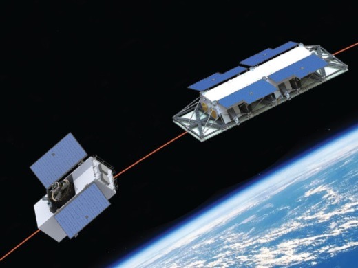
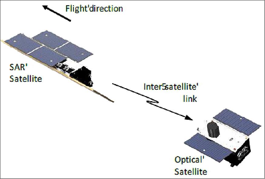
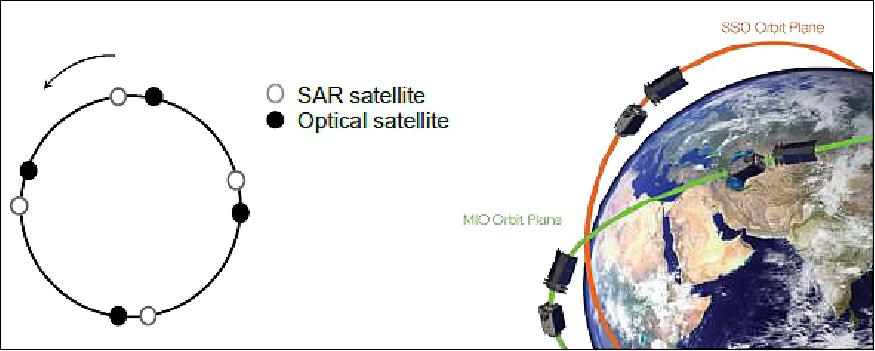
The OptiSARTM Constellation comprises 8 tandem pairs of SAR and Optical Satellites divided into two orbit planes. The 4 tandem pairs will be equi-spaced around an orbit plane, where each tandem pair consists of a leading SAR satellite, which uses UrtheCast's SAR-XL technology for its payload, and a trailing Optical satellite that is following approximately 2 minutes behind the SAR satellite. Figure 4 shows the OptiSARTM tandem satellite pair configuration.
The first orbit plane is a SSO (Sun-Synchronous Orbit) with a 10:30 hour equator crossing time that is a commonly used orbit for Earth Observation missions, and the second plane is a MIO (Mid-Inclination Orbit) with a ~45º inclination. The MIO is used to provide ultra-high revisit in mid latitude regions of the Earth where the bulk of the world's population reside. Both orbit planes have a satellite altitude of 450 km. The orbit plane configuration and the satellite phasing within each orbit plane is given in Figure 5.
The OptiSARTM constellation represents a capability shift in space-based remote sensing. The optical satellite uses a high-resolution (0.5 m GSD) dual-mode (multi-spectral pushbroom and RGB color video) optical camera, while the SAR satellite uses UrtheCast's SAR-XL technology that provides a dual-band (X-band and L-band) SAR instrument configured with 6 fully independent apertures. The SAR-XL payload provides 1m class X-band (VV polarization) imagery and 5 m class fully polarimetric L-band imagery.
Development Status
• August 14, 2017: UrtheCast Corporation announced today that it has entered into a contract with a confidential customer for the development and delivery of a dual-frequency standalone Synthetic Aperture Radar (SAR) operational-class satellite as an "accelerator" for the OptiSARTM Constellation. The exact amount of the contract is not being disclosed at this time for confidentiality and competitive reasons, but the Company can confirm that it is a substantial contract worth in excess of one hundred million Canadian dollars. The contract is for the delivery of the SAR spacecraft, key elements of the ground segment, namely the mission control and planning system and the SAR processor, and in-orbit operations support, but does not include the price of the launch or insurance (which are the customer's responsibilities). This confidential customer has previously signed a MOU (Memorandum of Understanding) with the Company for the OptiSAR Constellation. 12)
- The contract is subject to the customer obtaining final government appropriation approval and to UrtheCast and its suppliers obtaining technology transfer export permits on terms agreeable to the customer. Subject to these conditions being met, work on the program is anticipated to begin in early 2018, for launch in late 2020. Payments by the customer to UrtheCast under the contract are conditional on the Company successfully reaching various program delivery milestones. As part of the deliverables under the contract, UrtheCast has also agreed to provide elements of the satellite ground segment and post-launch maintenance and operational support, each to be further detailed and extended in separate definitive contracts.
- Using the same SAR technology that the Company has been developing for the OptiSAR constellation, this contract will allow UrtheCast to accelerate both the operationalization of its SAR technology and the start of our SAR data services business. The contract enables the Company to build and launch a SAR satellite as a precursor mission (or "accelerator") to the OptiSAR Constellation and to thereby demonstrate its high-capacity, high-throughput, fully-operational class capability with an unprecedented range of imaging modes and scientific-grade data quality. Under the contract, the parties have agreed to enter into a separate definitive contract to provide UrtheCast with the exclusive commercial distribution rights to the customer's unused satellite imaging capacity outside specified regions on a shared 50/50 net revenue basis, allowing the Company to sell the SAR-XL data and SAR-derived services in advance of the deployment of the OptiSAR constellation—the date of which is now pushed out by at least a year.
OptiSARTM Optical Satellites
The OptiSARTM Optical satellites (Figure 6) is a highly agile, high-resolution Earth Observation platform originally based on the SSTL 300 system, but given the need to service a large complex imager, it is a 700 kg class satellite. Although a "large" satellite, its core architecture is the same as the SSTL300 and largely uses similar avionics.
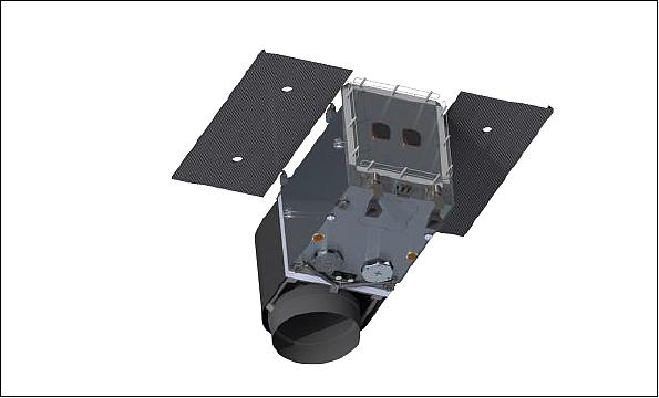
It will fly a HRC (High Resolution Camera) designed and built by SSTL with a seven band pushbroom still camera, plus a color video, as described in Table 1.
The HRC-DM includes a focus mechanism that allows focus after launch to compensate for barrel moisture outgassing and seasonal focus to maintain MTF (Modulation Transfer Function) performance. This has been successfully used in previous SSTL satellites and focus mechanisms are now routinely used in high resolution missions.
The HRC-DM delivers pushbroom strips of up to 8.5 minutes (equivalent to ~3600 km strip length on ground) as well as supporting area & stereo modes and video modes. Additionally the satellite also flies a meteorological camera, known as the MetCam that supports atmospheric correction in the ground post-processing of the imagery captured by the HRC-DM.
Each satellite has on-board data storage for 3 TB of non-volatile flash memory and it supports JPEG-LS or JPEG-2000 compression with variable compression ratios up to 5:1. Each satellites has two X-band data transmitters, using together to deliver 2 x 800 Mbit/s using cross-polarized antennas.
Aperture diameter | 0.56 m |
Swath width | 12.28 km (pushbroom), 1.9 x 2.5 km (video) |
GSD (Ground Sampling Distance) native | 0.5 m PAN, 1.0 m MS, 0.5 m Video |
Spectral bands - pushbroom | Panchromatic, Blue, Green, Red, NIR, Red-Edge, Yellow |
Spectral bands - video | RGB |
Video frame rate | 30 fps |
OptiSAR™ SAR Satellites
The OptiSAR SAR satellite is a dual frequency X- and L -band SAR, built around the SAR-XL payload that is the world's most technologically advanced SAR. There is no SAR operating, or under development that embodies all of the capabilities and technologies of the UrtheCast SAR-XL in a single instrument. Additionally, the satellites carry an S-band ISL (Inter-Satellite Link) to the optical spacecraft (Tx only), providing processed data to enable autonomous scheduling on board the optical S/C for cloud optimization/avoidance and maritime surveillance.
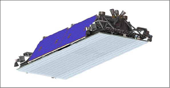
The design of the satellite started with a standard SSTL300 as the basis bus, but given the size of the instrument and the power requirements has evolved to a large platform, of around 1.800 kg of mass. The core avionics and architecture are directly derived from the SSTL300 series and are common to the Optical satellites, allowing for communality of operational concepts. This together with the re-use of the avionics design allows for a significant reduction of the cost of the satellite. The production of a series of these satellites at the same time as the optical satellites further reduces the cost.
The SAR-XL technology is the world's first dual-frequency, quad polarization, multi-aperture, fully-active phased-array and all digitally-beamformed (in both azimuth and elevation) spaceborne SAR ( Synthetic Aperture Radar). The SAR-XL instrument is architected and designed to be highly flexible in terms of operational beam modes and also modular in nature so the antenna can be sized to achieve the performance required. Each aperture is essentially a complete SAR instrument unto itself, so that the SAR antenna can be made up of a selected number of individual apertures. The flexibility provided by the instrument can serve a wide variety of applications that includes commercial geoanalytics applications such as crop monitoring, forest structure modelling and biomass estimation, soil moisture retrieval, as well as very high resolution surveillance and wide-swath maritime domain surveillance for ship detection, ice monitoring and ocean winds.
The SAR-XL instrument has a dual-frequency (L- and X- band) shared aperture phased-array antenna, driven by multiple digital receiver-exciters. Each antenna aperture segment is 1.8 m (in elevation) x 1.0 m (in azimuth). The OptiSAR™ constellation SAR satellite uses an antenna with 6 dual-frequency apertures, although the SAR-XL design is scalable and can accommodate any number of apertures in principle. For example, a configuration with 16 apertures is possible with the current hardware.. These apertures are combined digitally to form the transmit beam, and to form multiple simultaneous receive beams, in both azimuth and elevation.
This architecture, as well as other features of the multiple digital receiver exciters, results in a Multi-Aperture Multi-Frequency Digitally Beamformed SAR with full MIMO (Multi-Input-Multi-Output) capabilities. To further extend the dimensionality of the trade space that this MIMO SAR architecture enables, SAR-XL takes the MIMO architecture further, providing digital simultaneous beamforming of multiple azimuth and elevation beams, at both X-band and L-band, from the same aperture. It is these capabilities that allow a relatively small antenna to meet the requirement of wide swath surveillance modes without excessive range ambiguities.
The SAR-XL dual-frequency shared aperture antenna uses highly efficient radiators integrated directly into the structural elements in such a manner that every piece of metal forms multiple functions of electromagnetic radiation, power distribution, structural strength, and thermal management. The antenna itself is also the support structure for the electronics units.
SAR-XL Beam and Mode Specifications
The UrtheCast OptiSAR™ constellation will fly a 6 aperture configuration SAR-XL resulting in an antenna 6 m in length (azimuth) by 1.8m (elevation). This configuration of the SAR-XL instrument has been modeled and analyzed in detail, and the models were confirmed by ground tests of the prototype antenna. The baseline beam modes are illustrated in Figure 8 with a brief description provided below.
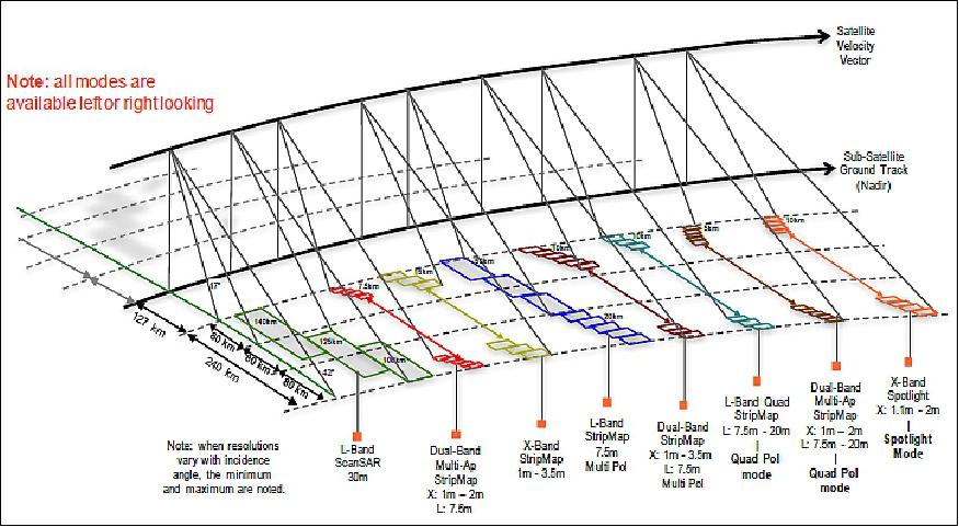
Spotlight Mode products will have a nominal scene size of 10 km (cross-track) by 5 km (along-track) with an X-band ground resolution as fine as 1.0 m by 1.1 m (Range x Azimuth), typical ambiguity ratios of -25 dB and typical NESZ of between -20 dB and -24 dB.
Multi-Aperture StripMap Mode products will have a nominal swath width of 7.5 km with an X-band ground resolution as fine as 1.0 m by 1.0 m (Range x Azimuth), typical ambiguity ratios of -19 dB and typical NESZ of between -19 dB and -23 dB. The multi-aperture stripmap mode products have approximately the same resolution as spotlight mode products, but they are capable of yielding long strips providing much greater coverage.
Dual-Band StripMap Mode products will have a nominal swath width of 10 km. The X-band ground resolution will be 1.0 m by 3.5 m (Range x Azimuth), with typical range ambiguity ratios of -20 dB to -25 dB, typical azimuth ambiguity ratios of -19 dB to -22 dB, and typical NESZ of between -23 dB and -26 dB. For single, dual and compact polarizations, the L-band ground resolution will be 7.5 m x 7.5 m, with typical ambiguity ratios of -22 dB and typical NESZ of between -23 dB to -26 dB. For L-band quad polarization, the swath width will be 7.5 km and the ground resolution will be 16 m x 7.5 m (Range x Azimuth), with a typical range ambiguity ratio of -26 dB, typical azimuth ambiguity ratio of -21 dB, and a typical NESZ of between -28 dB and -30 dB.
ScanSAR Mode products will have a nominal swath width of 140 km, with an L-band ground-range resolution of 30 m by 30 m (Range x Azimuth), typical range ambiguity ratio between -21 dB to -24 dB, typical azimuth ambiguity ratio between -19 dB to -22 dB, and typical NESZ of between -23 dB to -26 dB. In addition there are ScanSAR modes optimized for Ship Detection that have 225 km swath widths and have very good ship detection performance in high sea states (e.g., sea state 5).
OptiSARTM CONOPS
A key feature of the OptiSARTM constellation is the cross-cueing capability between the SAR and optical satellites which enables the system to have a wide swath surveillance mode with the SAR satellite and, using onboard processing, detect and classify objects of interest (e.g., ships), and then automatically task the optical satellite to take a high-resolution image or video of the selected objects within 2 minutes.
In summary — the ability to build constellations of satellites dramatically improves their usefulness, be it by significantly increasing the temporal resolution of the system, or by allowing the deployment of complex systems that would not be possible with single satellites. In the case of OptiSARTM, the ultimate goal is to combine these two facets: combine formation flying optical-SAR pairs, with a sufficient total number of satellites to provide good temporal resolution.
Building large constellations of this type requires low cost technical solutions, capable of handling the large and complex payloads that are required to achieve the performance. Re-using existing designs and keeping the system design simple, whilst keeping focus on cost effective choices, allows the business case for these constellations to close.
A constellation like OptiSARTM will deliver a paradigm shift in the use of EO data: "multi-dimensional", rich EO data will become available to the user community, allowing a new set of analytics to be derived of satellite borne data. And at an affordable price!
References
1) Amar Vora, Liam Sills, Andrew Cawthorne, Alex da Silva Curiel, Martin Sweeting, George Tyc, "The World's First Commercial SAR and Optical 16-Satellite Constellation," Proceedings of the 67th IAC (International Astronautical Congress), Guadalajara, Mexico, Sept. 26-30, 2016, paper: IAC-16- B1,2,11
2) Theras Wood, "UrtheCast Announces World's First Commercial SAR And Optical 16-Satellite Constellation," June 19, 2015, URL: http://tinyurl.com/pdq7wxq
3) Peter B. de Selding, "UrtheCast Shelves New ISS Camera To Focus on Satellite Constellation ," Space News, Nov. 12, 2015, URL: http://spacenews.com/urthecast-shelves-new-iss-camera-to-focus-on-satellite-constellation/
4) Peter B. de Selding, "UrtheCast wants 8 satellites on top of 16 Surrey stands to build," Space News, March 31, 2016, URL: http://spacenews.com/urthecast-says-16-satellite-high-resolution-radaroptical-constellation-isnt-enough-will-add-8-medium-resolution-spacecraft/
5) Theras Wood, "UrtheCast Announces Establishment of a Cooperative Research and Development Agreement with the National Geospatial-Intelligence Agency," April 4, 2016, URL:http://tinyurl.com/govhhqq
6) Theras Wood, "UrtheCast Reports Major Milestone Achieved in Proving its Revolutionary Dual-Frequency SAR Technology," May 2, 2016, URL: http://tinyurl.com/hwooepl
7) "UrtheCast to Receive Industry Canada Technology Development Program Award of $5 Million to Support Development of its OptiSAR™ Constellation," UrtheCast, May 26, 2016, URL: https://blog.urthecast.com/press/urthecast-receive-industry-canada-technology-development-program-award-5-million-support-development-optisar-constellation/
8) "UrtheCast Enters into Binding Agreement Worth US$180 Million to Sell and Operate Two Satellites in the OptiSAR™ Constellation," UrtheCast, Jan. 17, 2017, URL: http://investors.urthecast.com/file.aspx?IID=4388192&FID=37540001
9) G. Sadlier, "The Case for Space 2015 - The impact of space on the UK economy," A study for the Satellite Applications Catapult,Innovate UK, UKspace and the UK Space Agency, London Economics, London, July 2015, URL: https://www.ukspace.org/wp-content/uploads/2019/04/LE-Case-for-Space-2015-Full-Report.pdf
10) Luis Gomes, Nimal Navarthinam, Andrew Cawthorne, Alex da Silva Curiel, George Tyc, Martin Sweeting, "Rich Data, Cheap Satellites," Proceedings of the 31st Annual AIAA/USU Conference on Small Satellites, Logan UT, USA, Aug. 5-10, 2017, Paper: SSC17-XI-06, URL: http://digitalcommons.usu.edu/smallsat/2017/all2017/151/
11) Peter Fox, George Tyc, Keith Beckett, "The UrtheCast SAR-XL Multi-Band, Multi-Aperture Spaceborne SAR System," 2017 IEEE Radar Conference, Seattle WA, USA, May 8-12, 2017
12) "UrtheCast Announces the Signing of a Contract exceeding $100M for the Delivery of a SAR-XL Satellite as an "Accelerator Mission" for the OptiSAR™ Constellation," Newswire, Aug. 14, 2017, UR L: http://www.newswire.ca/news-releases/urthecast-announces-the-signing-of-a-contract-exceeding-100m-for-the-delivery-of-a-sar-xl-satellite-as-an-accelerator-mission-for-the-optisar-constellation-640373073.html
The information compiled and edited in this article was provided by Herbert J. Kramer from his documentation of: "Observation of the Earth and Its Environment: Survey of Missions and Sensors" (Springer Verlag) as well as many other sources after the publication of the 4th edition in 2002. - Comments and corrections to this article are always welcome for further updates (eoportal@symbios.space).
The Constellation The Original 'New Space' Way References Back to Top