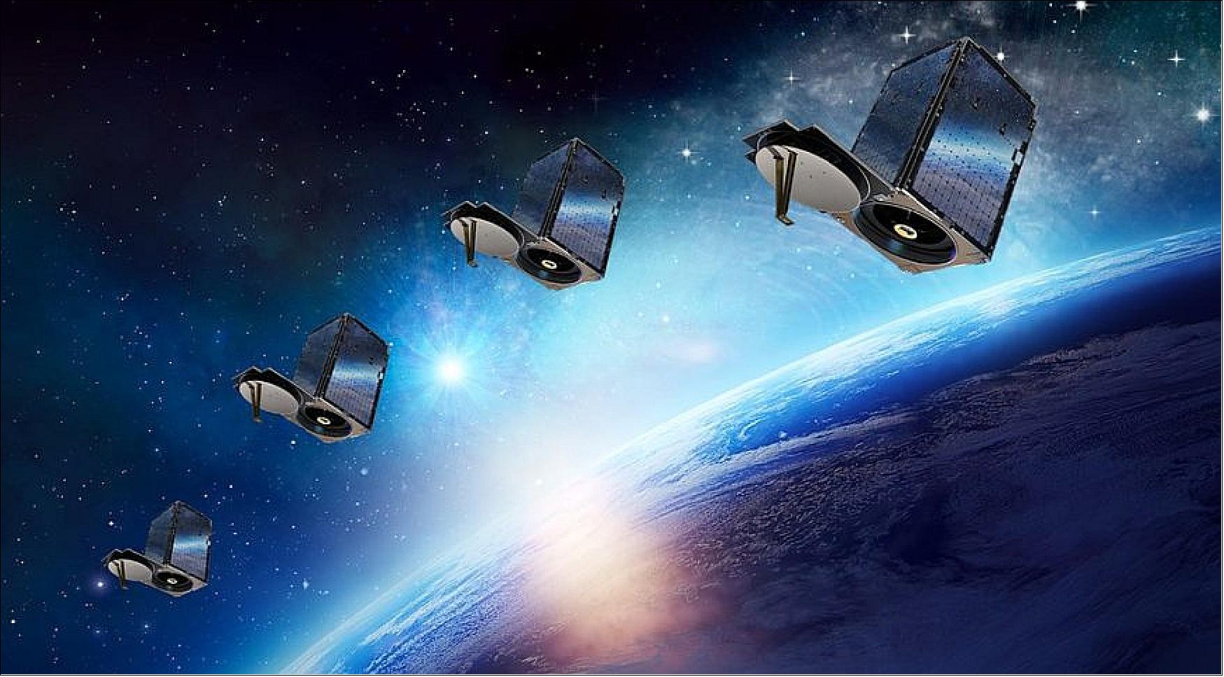
Planet - Flock Imaging Constellation
EO
Quick facts
Overview
| Mission type | EO |
Planet - Flock Imaging Constellation
On November 26, 2013, Planet Labs, a private start-up company of San Francisco, CA, announced that it successfully launched its most recent nanosatellites, Dove 3 and Dove 4, into orbit on a Dnepr vehicle (launch on Nov. 21, 2013 from the Yasny Cosmodrome, Russia), completing a series of four prototype nanosatellites in 2013. Those proved successful, enabling the company to quickly follow up with the production of a 28-member network. The launch of Planet Labs’ "Flock 1" fleet of 28 nanosatellites in December/January, which will be the largest constellation of Earth-imaging satellites ever launched. 1) 2)
The latest additions to the Planet Labs fleet offer improvements in the capability provided by the firm’s first nanosatellites launched in April, Dove 1 and Dove 2, which also were 3U CubeSats. Dove 3 and Dove 4 will demonstrate the firm’s latest technology, including upgraded communications, attitude control and observation technology.
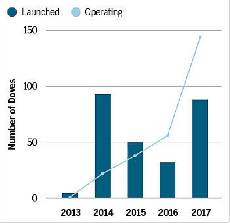
Background: Planet Labs was founded in 2010 by Chris Boshuizen, Will Marshall and Robbie Schingler, three NASA alumni interested in altering the space industry. Their “Dove” nanosatellites are meant to be low-cost and rapidly deployable, and capable of taking pictures of Earth that provide a spatial resolution of 3-5 m. — On March 17, 2014, Planet Labs announced that it has confirmed launches for more than 100 satellites over the next 12 months. This full constellation of nanosatellites will allow Planet Labs to image the entire Earth every day. 3)
Spacecraft
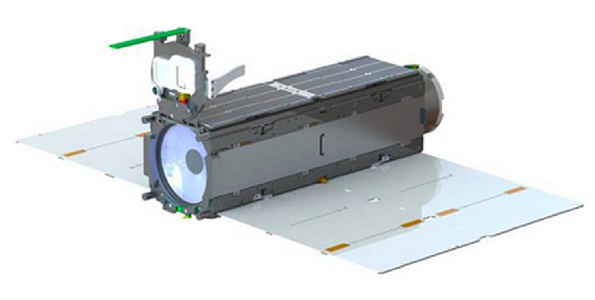
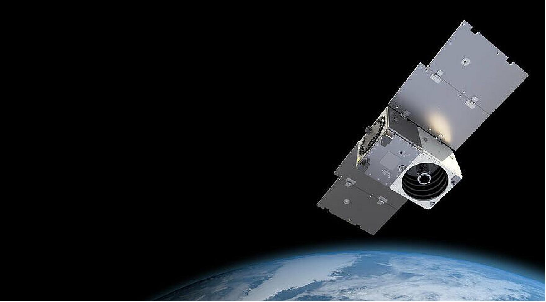
The Flock 1 constellation nanosatellites (all 3U CubeSats) were designed and built by Planet Labs Inc. They feature mostly COTS (Commercial-off-the-Shelf) components, including their imagers. Each nanosatellite has a mass of ~5 kg and a size of 10 cm x 10 cm x 34 cm.
It can be expected, that the Flock 1 nanosatellite design corresponds closely to the design of the prototype Dove series, which demonstrated that the company’s engineers can accurately position the orbiters and capture a continuous stream of imagery with a resolution of 3-5 m.
ADCS (Attitude Determination and Control Subsystem): The attitude is sensed by magnetometers, gyros and photodiodes. The attitude is being controlled by magnetorquers and reaction wheels. The B-dot controller makes use of the B field to reduce the angular rate of the satellite. In this control mode, Dove-1 therefore behaves as a permanent magnet, remaining locked and axis-aligned to the Earth’s magnetic field. - Dove-1 will be nadir pointing twice per orbit. The alignment of the magnetic field is known to about 1º at any point.
EPS (Electrical Power Subsystem): The bus provides central power control through a power supply to the camera, the flight computer and the magnetorquers. The power supply regulates the voltages and ensures a stable power supply to each component. Power storage is provided by 8 Lithium-ion cells, providing 20 Ah of charge at full capacity. The batteries will be recharged by body-mounted TASCs (Triangular Advanced Solar Cells).
C&DH (Command & Data Handling) subsystem: C&DH is controlled by the single board computer. Additionally there will be a discrete watchdog board that will be able to reboot the flight computer in the event of errors.
RF communications: The communication subsystem consists of a VHF radio beacon for transmitting telemetry and an S-band frequency hopping spread spectrum modem for two-way communication and as the primary radio for data downloading. After powering up, the first mission event is to transmit telemetry data over the VHF beacon. The beacon will transmit health packets (including temp/power supply/current/RSSI/solar vector/acceleration) at 1200 baud AFSK approximately every 30 seconds (AX.25 protocol, 145.825 MHz). The beacon can transmit at up to 1 W and will use a quarter wave monopole antenna cut from tape measure.
The S-band radio will operate in the 2.4 GHz half-duplex ISM (Industrial, Scientific and Medical) band at a wireless link rate of 115 kbit/s using a patch antenna.
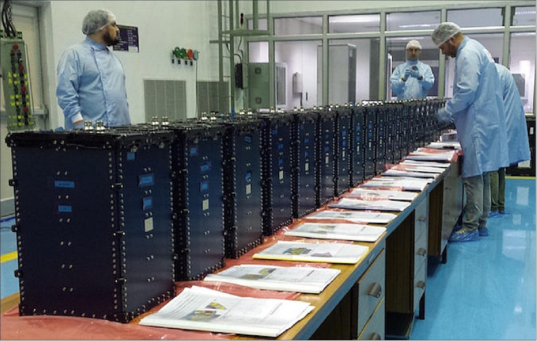
In Nov. 2013, Planet Labs' Flock 1 nanosatellites were delivered to NASA's Wallops Flight Facility in Virginia for launch on board an Antares rocket in December 2013. These satellites were built in production at the Planet Labs headquarter offices in San Francisco. Planet Labs is on track to launch 32 satellites on four different launches in 2013. 5)
Radio Development History(update to RF communications): 6)
In order to meet Mission 1 data volume objectives, Planet built a custom high-speed X-band radio using COTS components that is tightly integrated with the rest of the CubeSat bus. Several radio architecture decisions were made in order to meet the size, weight, and power (SWaP) constraints of the CubeSat platform while also improving the overall system efficiency. For example, the final stage RF power amplifier was integrated adjacent to the antenna to improve the total system power efficiency. This allowed the use of antenna solutions with 10-12 dBi gain, but still achieve data rates comparable to much larger class satellites that typically have very high gain antennas.
The custom development solution also allowed for rapid prototyping and repeated iterations that led to continuous improvements to the radio subsystem. Planet's first satellite launch hosted the sixth iteration (Build 6) of the spacecraft that transmitted 2 W of RF power through a 3 dBi gain patch antenna. A 6.1 m dish at the Chilbolton Observatory in the UK served as the ground station antenna. On April 25, 2013, Planet achieved its first successful X-band downlink at 4 Mbit/s data rate, which set a new data rate record for CubeSat class satellites.
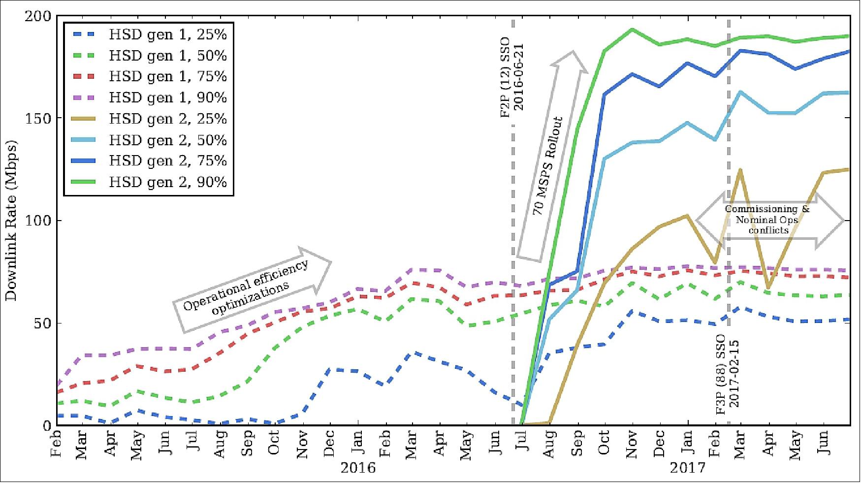
The success of the early launches and tech demos proved that Planet could meet its Mission 1 goals by following the \agile aerospace" philosophy of rapid prototyping, repeated iterations, and continuous improvements. Less than three years after the first launch, the thirteenth iteration (Build 13) of the satellites was launched on the Indian Polar Satellite Launch Vehicle (PSLV) in June 2016. This constellation code named Flock 2P or F2P included twelve \Build 13" satellites (launch in June 2016). Further improvements were made to this build and Flock 3P or F3P consisting of 88 satellites was launched in February 2017. With the F3P launch, Planet set a record for the most number of operational satellites (100 Build 13 satellites and several B10, and B12 satellites). Planet has demonstrated 220 Mbit/s peak data rates with the Flock 3P constellation and average data rates of approximately 160 Mbit/s. Cumulatively, these satellites generate several TB of imagery data daily that is downlinked to eight geographically diverse ground station sites.
Improvements to the spacecraft HSD (High-Speed Data) system have followed Planet's iterative design approach. Higher gain antennas have been added and improved, RF circuit impairments have been addressed, amplifier settings have been optimized, and the radio firmware and software has undergone constant development. Table 1 provides a summary of key HSD development milestones.
Date | Milestone | Build#,HSD# | Improvements |
Apr. 21, 2013 | Dove 1 | B6, HSD1 | HSD1 with operational X-Band system with patch antenna (3 dBic), achieved 4 Mbit/s using QPSK modulation scheme at 1/2 FEC rate. |
Nov. 21, 2013 | Dove 3 | B8, HSD1 | Upgraded system with ACM (Adaptive Coding and Modulation), high gain helical antenna (10 dBic), achieved 25Mbit/s using 8PSK modulation at 8/9 FEC rate. |
June 19, 2014 | Flock 1c (11 satellites) | B9, HSD1 | Increase symbol rate from 10 Mbaud to 20 Mbaud and achieved 34 Mbit/s using QPSK modulation at 8/9 FEC rate |
June 1, 2016 | Flock 2e (12 satellites) | B12, HSD1 | Increased symbol rate to 24 Mbaud, improved helical antenna (12 dBic), optimized and linearized the X-Band transmitter chain and achieved 100 Mbit/s using 32 APSK modulation and 8/9 FEC rate |
June 21, 2016 | Flock 2p (12 satellites), | B13, HSD2 | HSD2 with new hardware, firmware, and software improvements on satellite and ground station, symbol rate increased from 24 Mbaud to 70 Mbaud, achieved 220Mbit/s using 16 APSK modulation and 3/4 FEC rate (Raw RF link rate achieved 283 Mbit/s) |
The HSD radio operates at X-band with a center frequency of 8150 MHz and 70 Mbaud symbol rate. This frequency is within the 8025-8400 MHz (X-band) range where EESS (Earth Exploration Satellite Service) has a primary spectrum allocation.
Launches
The Cygnus CRS-1 logistics flight of Orbital Sciences to the ISS was launched on Jan. 09, 2014 on an Antares-120 Vehicle of OSC from MARS (Mid-Atlantic Regional Spaceport), Wallops Island, VA. 8)
Cygnus CRS-1 (Commercial Resupply Services) Orb-1 logistics flight of Orbital Sciences is the second Cygnus flight to the ISS (International Space Station) and the third launch of the company's Antares launch vehicle from MARS (Mid-Atlantic Regional Spaceport), Wallops Island, VA. The flight is the first of 8 under the CRS (Commercial Resupply Services) contract to NASA. The mission is scheduled to launch on December 18, 2013. Cygnus is expected to deliver 550 kg of cargo to ISS and dispose of about 1,000 kg through destructive reentry.
Orbit: Near-circular orbit of the ISS, altitude between 370-430 km, inclination = 51.6º. — Planet refers to a group of Doves deployed simultaneously into a single orbit as a flock.
Secondary payloads: commercial payloads of Orbital Sciences.
Part of the Cygnus payload consists of 33 CubeSats which will be deployed in early 2014 with the NanoRacks Smallsat Deployment Program using the J-SSOD (JEM-Small Satellite Orbital Deployer), located in the airlock of the JEM/Kibo module of JAXA.
The CubeSats are:
• 28 Flock 1 3U CubeSats, the first generation of an Earth observation constellation of Planet Labs. They will be placed into 400 km circular orbits (inclination of ~52º), providing imagery with a resolution of 3-5 m. 9)
• LituanicaSAT-1, a CubeSat which will carry a VGA camera, a GPS receiver and a voice transponder. The satellite has been developed at the Vilnius University (Lithuania) and has been named after the aircraft named Lituanica that flew across the Atlantic Ocean 80 years ago.
• LitSat, a 1U CubeSat developed by the Lithuanian Space Federation. The satellite will carry an onboard VGA camera and a GPS receiver.
• UAPSAT, a 1U CubeSat developed by UAP (Universidad Alas Peruanas), Lima, Peru, as a student educational project. Once in orbit the satellite can be accessed by radio amateurs; UAPSAT will test the behavior of electronic design communication, orientation and stabilization and verify the implementation of the technology and methodology used in the manufacture of the satellite.
• SkyCube, a 1U CubeSat developed by the Southern Stars Group LLC (San Francisco, CA) and funded by thousands of sponsors and mobile app users around the world (crowd funding). Its objective is to facilitate global grassroots public outreach and educational effort whose purpose is to make space exploration accessible as never before by allowing participants to send simple broadcasts - "tweets from space". The satellite is also fitted with a camera for on-demand pictures of Earth. At the end of the 90 days mission, SkyCube will inflate an onboard balloon that will make it visible to the unaided eyes and assist in de-orbiting the satellite cleanly through atmospheric drag. 10)
• Ardusat-2, developed by Nanosatisfi LLC, which is similar to the Ardusats that were sent to ISS earlier this year.
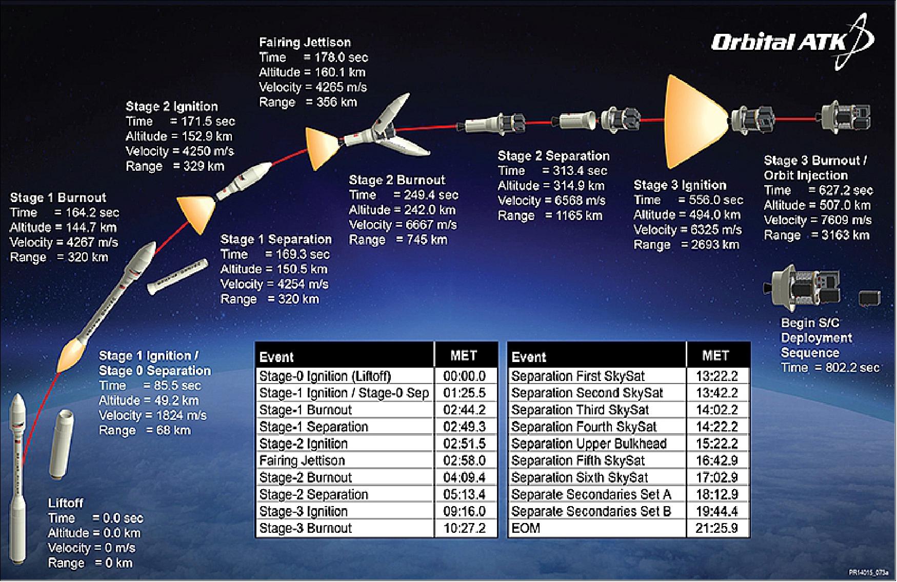
On Oct. 31, 2017 (21.37 UTC), six SkySat minisatellites of Terra Bella (a Planet Labs company) and 4 Dove (Flock-3m) nanosatellites of Planet Labs were launched on a Minotaur-C vehicle of Orbital ATK from VAFB, CA (SLC-576E). The Minotaur-C is an upgraded, renamed version of the Orbital Sciences Taurus rocket. Approximately 12 minutes into flight, the ten commercial Planet spacecraft deployed into their targeted sun synchronous orbit of 500 km altitude. 11) 12)Orbit: Sun-synchronous orbit, altitude of ~500 km, inclination of ~97º.
Pelican-1, along with 36 of its SuperDoves, Flock 4Q, were successfully launched to orbit on SpaceX’s Transporter-9 mission from Vandenberg Space Force Base on Saturday, November 11, 2023.
For a complete list of all the Launches, please refer to Table 2.
S/C Name | Launch Vehicle | Launch Date | No of satellites launched | Status |
|---|---|---|---|---|
RapidEye | Dnepr | Aug. 29, 2008 | 5 | Operational |
Dove 2 | Soyuz 2.1b | April 19, 2013 | 1 | Retired |
Dove 1 | Antares | April 21, 2013 | 1 | Reentered |
Dove 3 | Dnepr | November 21, 2013 | 1 | Retired |
Dove 4 | Dnepr | November 21, 2013 | 1 | Failed Deployment |
SkySat 1 | Dnepr | November 21, 2013 | 1 | Operational |
Flock 1 | Antares | January 9, 2014 | 28 | Reentered |
Flock 1c | Dnepr | June 19, 2014 | 11 | Retired |
SkySat 2 | Soyuz 2.1b | July 8, 2014 | 1 | Operational |
Flock 1b | Antares | July 13, 2014 | 28 | Reentered |
Flock 1d | Antares | October 28, 2014 | 26 | Failed Launch |
Flock 1d’ | Falcon 9 | January 9, 2015 | 2 | Reentered |
Flock 1e | Falcon 9 | April 13, 2015 | 14 | Reentered |
Flock 1f | Falcon 9 | June 28, 2015 | 8 | Failed Launch |
Flock 2b | H-IIB | August 19, 2015 | 14 | Reentered |
Flock 2e | Atlas V | December 6, 2015 | 12 | Operational |
Flock 2e’ | Atlas V | March 23, 2016 | 20 | Operational |
Flock 2p | PSLV | June 22, 2016 | 12 | Operational |
SkySat 3 | PSLV | September 16, 2016 | 1 | Operational |
SkySat 5-7 | Vega | September 16, 2016 | 4 | Operational |
Flock 3p | PSLV | February 15, 2017 | 88 | Operational |
| Flock-3p' | PSLV | January 12, 2018 | 4 | Decayed |
| Dove Pioneer | Rocket Lab Electron | January 12, 2018 | 1 | Decayed |
| Flock-3r | PSLV | November 29, 2018 | 16 | Operational |
| Flock-3s | Falcon 9 | December 3, 2018 | 3 | Operational |
| Flock 3k | Soyuz Rocket | December 27, 2018 | 12 | Operational |
| Flock-4a | PSLV | April 1, 2019 | 20 | Operational |
| Flock 4p | PSLV | November 27, 2019 | 12 | Operational |
| Flock-4e | PSLV | July 4, 2020 | 5 | Failed Launch |
| Flock-4v | Vega | September 3, 2020 | 26 | Operational |
| Flock 4e’ | Rocket Lab Electron | October 28, 2020 | 9 | Operational |
| Flock 4s | Falcon 9 | January 24, 2021 | 48 | Operational |
| Flock 4y | Falcon 9 | January 3, 2023 | 36 | Operational |
| Flock 4x | Falcon 9 | January 13, 2023 | 44 | Operational |
| Flock 4q | Falcon 9 | November 11, 2023 | 36 | Operational |
Item | ISS Orbit | SSO Orbit |
Sun angle | Varies over time | Consistent based on LTAN/LTDN, Can drift over several years |
Thermal environment | Solar beta angle maxima require special handling | Minor variation over the year |
Orbital altitude | 390 km - 450 km at deployment | About 500 km |
Inclination | 51.6º | ~98º |
Orbit lifetime | 12-18 months (depending on solar activity and drag profile) | 4-5 years |
Coverage | Missing northern Canada and Russia, Antarctica, southern tip of South America | Full Earth with some seasonal polar gaps |
Mission Status
• November 12, 2023: Planet Labs PBC (NYSE: PL) has announced that Pelican-1, the first tech demo satellite for the company’s next-generation, high-resolution Pelican fleet, along with 36 of its SuperDoves, Flock 4Q, were successfully launched to orbit on SpaceX’s Transporter-9 mission from Vandenberg Space Force Base on Saturday, November 11, 2023 — the Planet team has successfully made contact with each satellite and started its commissioning process. 95)
• November 17, 2021: Planet collaborates with New Light Technologies Inc. (NLT) to provide the Federal Emergency Management Agency (FEMA) with high-cadence and high-resolution satellite data, enhancing situational awareness for disaster response. Utilizing PlanetScope and SkySat satellites, the data supports predictive deep learning models for tornado damage, flood assessments in Texas, and visual evaluations of infrastructure damage caused by winter storms. Planet's archive imagery, dating back to 2009, enables before-and-after comparisons within 24 hours of catastrophic events, aiding FEMA in targeted relief efforts and long-term risk mitigation. The collaboration aligns with Planet's mission to support global communities by revealing near-daily global change, and it comes as part of Planet's merger agreement with dMY Technology Group, Inc. IV, transitioning into a publicly-traded public benefit corporation committed to accelerating humanity toward a more sustainable, secure, and prosperous world. 14)
• November 10, 2021: Planet has entered into an agreement to acquire VanderSat, a leading provider of advanced earth data and analytics. VanderSat's innovative products focus on water management and crop health, utilizing insights drawn from NASA, ESA, and JAXA satellite data. With a mission to serve one billion hectares of land by 2024, VanderSat's expertise complements Planet's goal to bridge the gap between real-world problems and remote-sensing science complexity. The acquisition, valued at approximately $28 million, includes shares of Class A common stock and cash. This strategic move enhances Planet's capabilities in agriculture, civil government, insurance, and finance, providing richer insights and more precise measurements. The transaction is set to close in Q4 2021, subject to customary conditions and the completion of Planet's business combination with dMY Technology Group, Inc. IV. 15)
• October 12, 2021: At the Explore 2021 user conference, Planet unveiled two significant products: Pelican, a next-gen satellite fleet set to enhance high-resolution SkySat imagery with improved resolution, more frequent revisit times, and reduced latency; and Fusion with SAR, an enhancement to the existing Fusion Monitoring product by incorporating Synthetic Aperture Radar (SAR) data from Sentinel 1. Pelican promises increased response times and superior image resolution, aiming to exceed SkySat's market-leading global revisit frequency. Fusion with SAR enhances agricultural sensing by overcoming cloud cover limitations, offering continuous monitoring of crop health and critical events. Planet's agile aerospace methodology and modularity enable rapid innovation, and the Pelican design leverages the Carbon Mapper constellation. With the planned merger with dMY Technology Group, Inc. IV, Planet aims to go public, fueling its Earth data platform expansion. Pelican's size will be market-driven, aligning with Planet's strategy to meet evolving demand and broaden its user base for remote sensing science. 16)
• July 23, 2021: NASA has expanded its contract with Earth imagery companies Planet and Spire Global, enabling broader access to satellite data for scientific research across U.S. federal civil science agencies. Planet's contract modification provides access to its PlanetScope and RapidEye satellite constellations for agencies like NOAA, USGS, NSF, and their funded researchers. Meanwhile, NASA extended its contract with Spire Global under the Commercial Smallsat Data Acquisition (CSDA) program, allowing the delivery of a comprehensive catalog of data from Spire's Earth-orbiting small-satellite constellation. These datasets will be archived and available for scientific purposes to U.S. federal agencies and NASA-funded researchers through the Smallsat Data Explorer (SDX) tool. The move aims to facilitate research on Earth's changes and their impact. 18)
• July 7, 2021: Planet Labs Inc. and dMY Technology Group, Inc. IV (NYSE: DMYQ) have entered into a definitive merger agreement, marking Planet's transition into a publicly-traded company valued at approximately $2.8 billion upon closing. Planet, a leading Earth data and analytics provider, generates 25 terabytes of daily data from around 200 satellites, operating on a subscription-based model with over $100 million in revenue. The merger includes $345 million in dMY IV's trust account, a $200 million PIPE led by BlackRock, and notable participants like Koch Strategic Platforms, TIME Ventures, and Google. Planet plans to utilize the proceeds for expanding operations and services to foster a more sustainable and secure planet. The transaction is anticipated to conclude later this year, with Planet continuing under its name and listed on the NYSE as "PL." The merger aims to accelerate Planet's mission of utilizing space to benefit life on Earth, catering to diverse sectors such as agriculture, forestry, government, and mapping, fostering sustainability and environmental monitoring. The merger transaction aligns with Planet's strategic vision to leverage data for global sustainability and environmental action as data becomes increasingly pivotal in driving the global economy. Planet's management team, led by CEO Will Marshall, will continue to steer the public company after the merger. 19)
• January 27, 2021: Planet, leading an alliance named RapidAI4EO, has secured a competitive grant under the Horizon 2020 program to advance continuous land monitoring applications in Europe, within The Copernicus Program and Services. The consortium, comprising industry leaders like Planet, Vision Impulse, VITO, IIASA, and ONDA DIAS/Serco Italia, aims to enhance measurements of the human footprint on Earth, addressing UN Sustainable Development Goals. The team plans to develop improved AI processes, leveraging Copernicus satellite data and advanced Fusion Monitoring products from Planet. Focused on the CORINE Land Cover program, the project aims to detect and classify changes in land cover and use at a higher level of detail and temporal cadence, contributing to the evolution of the Copernicus Land Monitoring Service products. The resulting training sets will be open-sourced for the broader remote sensing community's benefit. 20)
• January 24, 2021: Planet has successfully deployed 48 SuperDove satellites, part of its Flock 4s, on SpaceX's Transporter-1 mission, marking a record-setting launch with 143 satellites. The Flock 4s introduces new spectral bands, enhancing image sharpness and quality. The 48 SuperDoves, combined with over 100 existing satellites, will contribute to providing unparalleled medium-resolution global coverage. The data generated can be applied across various sectors, addressing critical issues such as agriculture, government, intelligence, forestry, and land use. Planet's Mission Operations team has achieved a 100% success rate in the initial contact with the first set of 40 satellites, with the remaining 8 set to be deployed from D-Orbit's ION platform in the coming weeks. The deployment follows Planet's commitment to advancing satellite technology and contributing to solving global challenges.21)
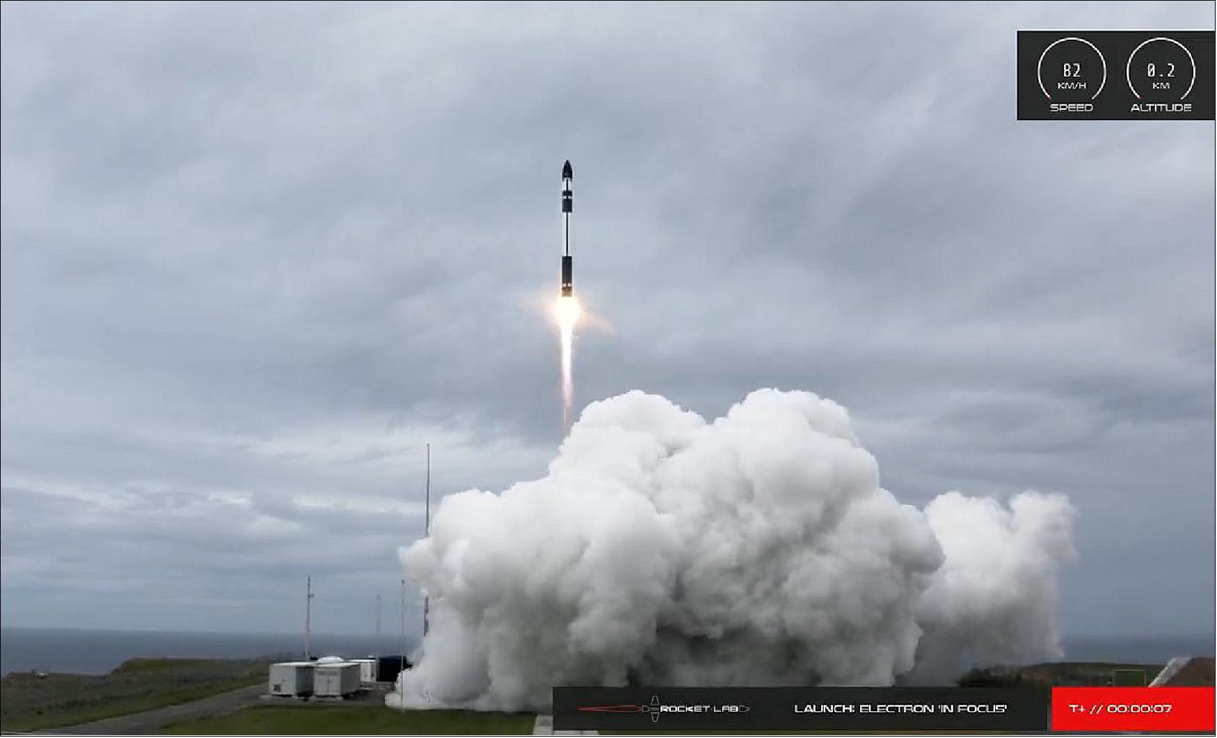
• October 28, 2020: Rocket Lab has successfully launched nine SuperDove satellites, known as Flock 4e', aboard its Electron rocket from the New Zealand launch site. The SuperDoves were deployed into a Sun Synchronous Orbit at an altitude of approximately 500 km, joining the existing constellation. Equipped with eight spectral bands, these SuperDoves provide Earth imagery with precise surface reflectance values, facilitating advanced algorithms and time-series analysis. The interoperability of Planet's SuperDoves with publicly available imagery, such as Copernicus' Sentinel-2, allows for innovative applications and use cases. Planet's Mission Operations team has established contact with all nine satellites, which are currently undergoing commissioning. This mission, named "In Focus," marks Rocket Lab's 15th launch and the third time carrying Planet satellites. 22)
• September 10, 2020: Planet successfully launched 26 SuperDoves (Flock 4v) on Arianespace's VV16 SSMS-POC flight, expanding its existing fleet. The company has now shared the first light images from the new flock, reporting that all satellites are healthy and on track for full commercial service. This achievement maintains Planet's impressive 100 percent record of successfully contacting every satellite deployed in space, totaling 357 satellites. With the addition of the new SuperDoves, Planet will continue to offer medium-resolution multispectral imagery (3-5m) globally, providing valuable intelligence at an unprecedented cadence for customers and organizations worldwide. 23)
• September 3, 2020: The Vega rocket successfully launched 26 SuperDoves, Flock 4v, as part of Arianespace's VV16 SSMS-POC flight, marking a significant achievement for the smallsat industry. The launch demonstrated Arianespace's rideshare mission, deploying 53 satellites for 21 customers from 13 countries. The first 14 SuperDoves were successfully deployed into a 530 km Sun-synchronous orbit, with Planet's mission operations team initiating the commissioning process. The remaining 12 SuperDoves will be deployed in the coming weeks from D-Orbit's ION platform. The diverse range of passenger payloads includes maritime microsatellites, CubeSats for meteorology and Earth observation, communication minisatellites, and nanosatellites for monitoring greenhouse gas emissions and climate data. The return of the Vega rocket to flight after corrective actions and delays due to the COVID-19 pandemic marks a notable moment for the industry. 24) 25) 26)
• March 24, 2020: Planet has announced a strategic partnership with Seisan, a custom software solutions and systems integration company specializing in geospatial technologies. Through its status as a premiere Planet partner, Seisan aims to leverage Planet's high temporal resolution geospatial data to create innovative solutions and gain a competitive edge in various industry verticals. By integrating Planet's dataset, Seisan plans to develop machine learning imagery analysis, traditional systems integration, and data transformation techniques, providing an advanced level of geospatial awareness. This collaboration seeks to enable companies to extract greater insights from location data, leading to increased productivity, operational cost reductions, and enhanced situational awareness. Seisan expressed excitement about utilizing Planet's extensive image archive to analyze historical data without the constraints of traditional geospatial methodologies, highlighting the potential for disruptive solutions across multiple sectors. Planet's daily imaging capabilities and Seisan's expertise in technology and innovation are expected to result in high-quality solutions meeting the immediate needs of enterprise customers. 30)
• February 13, 2020: Planet is set to launch 26 SuperDove satellites, part of the Flock 4v constellation, on Arianespace's Vega rocket from the Guiana Space Center. Scheduled for March 23, 2020, the launch was subsequently delayed due to COVID-19. The SuperDoves will be split into two batches, with 14 housed in ISL’s QuadPack deployers and 12 deployed from D-Orbit's InOrbit Now (ION) platform. This marks the first flight of D-Orbit’s InOrbit Now (ION) system, with plans to verify technologies for potential future use as a "space tug" capable of orbit adjustments or accelerating satellite phasing. The mission, named "Small Spacecraft Mission Service—Proof of Concept," represents a dedicated rideshare, bringing together multiple small satellites for the same orbit. Planet expresses gratitude to its partners, including Arianespace, ISISpace, D-Orbit, Spaceflight, and SAB Aerospace , for their collaborative efforts in realizing the mission. 31)
• November 27, 2019: Planet successfully launched 12 SuperDove satellites, known as Flock 4p, into a 509 km Sun Synchronous Orbit using India's Polar Satellite Launch Vehicle (PSLV) from SDSC SHAR. The launch, which marked Planet's 25th successful mission, occurred alongside ISRO's primary payload, CartoSat-3. Following the launch, Planet's Mission Operations team achieved contact with all 12 satellites, initiating satellite phasing and commissioning processes. This achievement maintains Planet's remarkable record of a 100 percent success rate in establishing contact with each Dove satellite post-launch. The Flock 4p satellites are currently undergoing detumbling maneuvers, subsystem health checks, solar panel deployments, and imagery system calibration. 32)
• October 14, 2019: Planet has launched Planet Orbit, a partner program that provides customers with access to geospatial data and aims to transform various industries through its unique dataset. The program allows partners to leverage Planet's robust APIs, PlanetScope daily imagery, and high-resolution SkySat tasking to create powerful solutions and differentiate their business. The initiative includes Gold and Platinum levels, offering benefits such as a dedicated portal, partner enablement with training and tools, access to an exclusive community, and for Gold and Platinum partners, dedicated Partner Business Managers and joint marketing activities. 33)
• August 2019: Planet has developed the HSD2 (High-Speed Downlink 2), the latest generation compact, low-mass, and low-power radio for its 3U form-factor imaging CubeSats. The HSD2 operates at X-band and achieves a data rate over 1.6 Gbit/s on-orbit, overcoming previous downlink limitations imposed by tight size, weight, and power (SWaP) constraints. Built on the success of the previous generation HSD Dove radio, the HSD2 features dual circular polarization antennas, a compact volume of 0.25U, a DVB-S2 modulation scheme with adaptive modulation and coding rates, and a total DC power consumption of 50W during downlink. The ground station network, consisting of 15 owned S/X-band antennas across five sites, supports both HSD1 and HSD2 downlinks, with hardware and software upgrades to accommodate multiple channels and dual polarization.
• April 2, 2019: The RapidEye satellite constellation has officially retired, marking the end of its image collection operations. Despite the discontinuation of new imagery acquisition, the extensive archive of RapidEye data will remain accessible to customers for both commercial and noncommercial purposes. To address the transition, users of RapidEye imagery have the option to shift to Planet's Next-Generation PlanetScope products, offering enhanced spatial resolution and continuity across key spectral bands, including red, green, blue, near-infrared, and red-edge, ensuring a seamless and upgraded imaging experience. 39)
• March 21, 2019: The National Geospatial-Intelligence Agency (NGA) has extended its contract with Planet, a commercial satellite imagery provider, for a six-month option worth $5.9 million. The agreement aims to further the integration of high-revisit imagery and automated processing into NGA's analysis processes, leveraging Planet's commercial data to meet the evolving technical requirements of the National System for Geospatial Intelligence community. The subscription contract facilitates the delivery of new daily imagery over specific areas, including the U.S. Southern Command region and zones of interest in the U.S. Africa Command and U.S. Indo-Pacific Command areas of responsibility, supporting combatant commands in their missions and enhancing automated analytic systems for monitoring operational environments. 40)
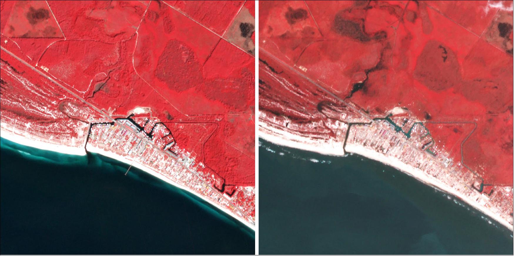
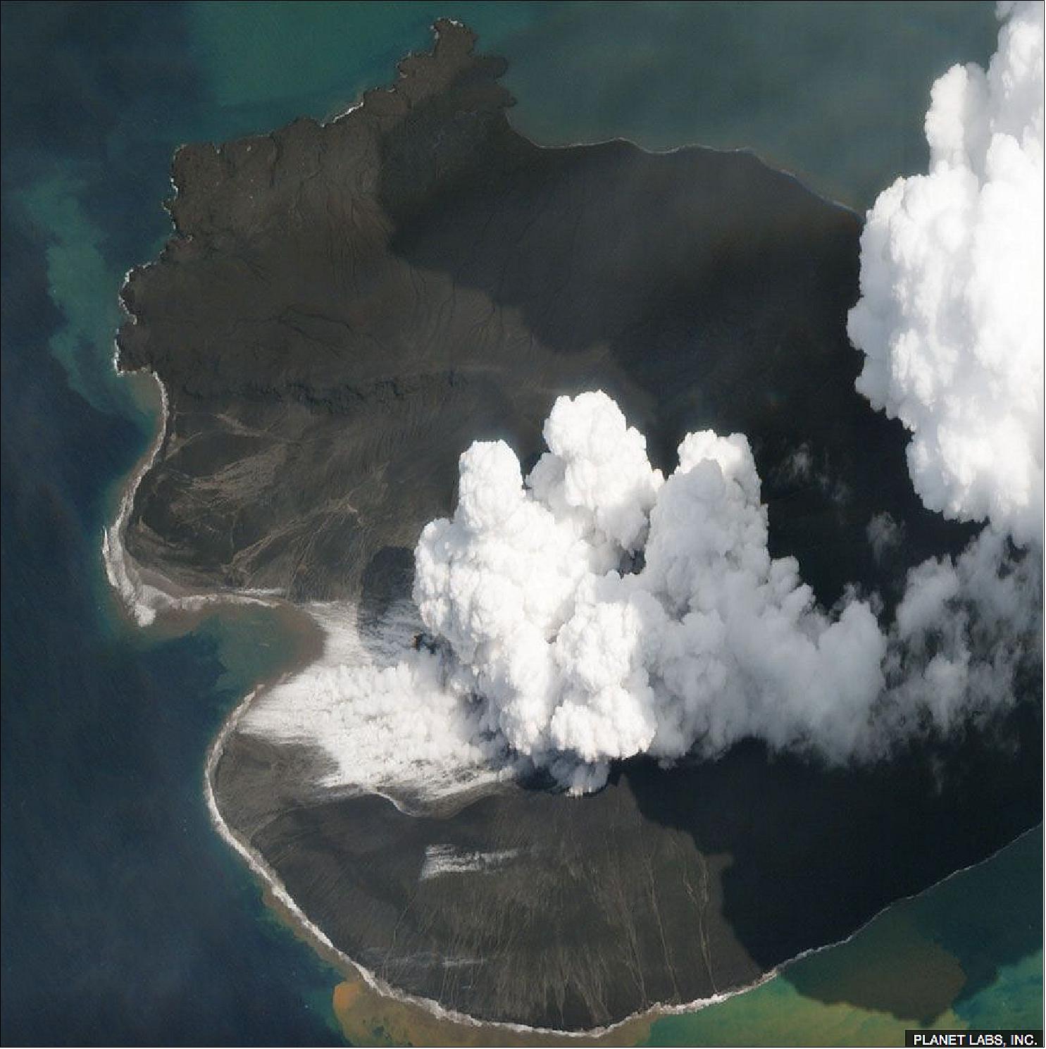
• January 3, 2019: Planet has provided high-quality optical satellite imagery revealing the aftermath of the collapsed Anak Krakatau volcano, which triggered a devastating tsunami in December 2018. Despite challenging weather conditions over Indonesia's Sunda Strait, Planet's Dove and SkySat platforms captured detailed images showcasing the extent of the volcanic cone's failure. The imagery highlights the transformation of the island, showing a broken-open summit crater that has formed a small bay. The Indonesian disaster agency reports a significant loss of Anak Krakatau's volume, with assumptions that a substantial portion slid into the sea during the massive landslide that caused the tsunami. Planet's extensive satellite constellation, consisting of small Dove spacecraft and high-resolution SkySat platforms, enabled clear observations by maximizing ground visibility when clouds dispersed. The optical satellite images complemented initial radar data, providing crucial insights into the collapse of Anak Krakatau. The disaster claimed the lives of approximately 430 people along the coastlines of Java and Sumatra, with many more displaced. 41) 42)
• December 28, 2018: Twelve Flock -3k 3U imaging CubeSats (each ~ 5 kg) of Planet Labs, were part of the secondary payload launched on 27 December 2018 on the Kanopus-V No 5 and No 6 minisatellite flight of Roscosmos on a Soyuz-2.1a / Fregat-M vehicle from the Vostochny Cosmodrome in Russia. 43) 44)
• December 3, 2018: Three Flock-3s series 3U CubeSats and 2 SkySats were part of the SSO-A rideshare mission of Spaceflight Industries launched on 3 December 2018 (18:34:05 GMT) on a SpaceX Falcon-9 Block 5 vehicle from VAFB (Vandenberg Air Force Base) in California. 45) 46)
• November 29, 2018: 16 Flock-3r series 3U CubeSats were part of the payload of ISRO's PSLV-C43 vehicle from SDSC (Satish Dhawan Space Center) SHAR on the east coast of India. 47) 48)
• October 4, 2018: NASA has initiated a pilot program, the "Private Sector Small Constellation Satellite Data Product Pilot," to assess the viability of integrating Earth science data from commercial small-satellite constellations with observations from NASA's existing fleet of Earth science missions. The agency awarded sole-source contracts to three private sector organizations—DigitalGlobe (a Maxar Technologies company), Planet, and SPIRE Global. The contracts, valued up to $7 million each, aim to acquire and evaluate data sets from the private sector's Earth-orbiting small-satellite constellations. This innovative approach seeks to leverage the strengths of NASA's aging research satellite fleet and the growing number of small satellites launched by private industry, potentially enhancing the completeness of climate data sets. NASA will provide the obtained data to its researchers to assess whether it contributes to the agency's science and applications development goals, exploring the cost-effectiveness of complementing NASA's Earth observations with private sector observations. 49)
• September 12, 2018: Planet has inaugurated its new satellite manufacturing and testing factory in San Francisco, marking a significant expansion in its capabilities. The 27,000+ square-feet state-of-the-art complex is six times larger than the previous lab, consolidating all aspects of spacecraft design and production in one location, from R&D to manufacturing and testing. This enhancement is expected to facilitate faster iteration and advancement of small satellites. The facility's flexibility enables simultaneous production of multiple spacecraft lines, including Doves and future satellite constellations. Notable features include a multi-purpose environmental testing facility for simulating space environments and ensuring hardware readiness for flight, reinforcing Planet's commitment to maintaining quality and agility in satellite development. 50)
• August 2018: Planet has successfully achieved its "Mission One" of imaging the entire landmass of the Earth every day using its Dove satellites. As of June 2018, Planet operates approximately 190 Doves, with replenishment launches planned to maintain and improve the constellation. The company is now focusing on "Mission Two," which involves applying machine learning and analytics to enable users to query Earth's imagery and build customized information feeds. Planet's Mission Operations team, distributed between the US and Europe, plays a crucial role in maintaining the health and performance of the Dove constellation, collaborating closely with subsystem teams, particularly the Attitude Determination and Control Subsystem (ADCS). Through iterative processes and a bias toward automation, Planet aims to optimize the operation of its constellations with a focus on efficiency and data-driven decision-making. 51) 52) 53)
• June 25, 2018: Planet has entered a partnership with Airbus, a remote sensing company, to facilitate mutual access to their data and collaborate on developing geospatial solutions. The agreement aims to offer customers a comprehensive suite of global remote sensing data at various temporal and spatial resolutions. Airbus brings high-resolution remote sensing capabilities, while Planet contributes its global coverage and temporal cadence. Together, the companies plan to deliver sophisticated offerings across commercial markets, combining their strengths to address diverse customer needs. 54)
• January 21, 2018: Rocket Lab's Electron vehicle, named "Still Testing," successfully achieved orbit and deployed customer payloads on its second test flight. The launch, which took place from Rocket Lab Launch Complex 1 in New Zealand, included the deployment of a Dove Pioneer Earth-imaging satellite for Planet and two Lemur-2 satellites for Spire Global. The successful deployment of customer payloads on an early test flight is considered a significant achievement, showcasing Rocket Lab's capability to provide commercial access to space. The company's future missions include launches for NASA, Spire, Planet, Moon Express, and Spaceflight, marking a milestone in commercial space access and emphasizing Rocket Lab's commitment to understanding and improving life on Earth. 55) 56)
• November 30, 2017: Human Rights Watch (HRW) has formed a strategic partnership with Planet to enhance its use of satellite imagery in documenting human rights violations worldwide. Planet will provide HRW with access to its extensive collection of high-resolution satellite data. This collaboration aims to facilitate the timely documentation of unfolding abuses, especially in regions with restricted access for human rights investigators. The use of satellite imagery has become crucial in exposing rights violations, particularly in conflict zones like Syria and Burma. HRW views this partnership as a significant step in enhancing its ability to monitor and report on complex events while holding those responsible for atrocities accountable. 57)
• October 31, 2017: Planet has successfully launched six SkySat satellites (SkySat 8-13) and four Doves (Flock 3m) aboard an Orbital-ATK Minotaur-C rocket. This marks Planet's 20th launch and the first dedicated launch, enabling the company to choose orbital parameters and launch timing. The satellites were deployed successfully, with the SkySats doubling the sub-1 meter imaging capacity of the current SkySat fleet. The launch aims to diversify Planet's product offerings, with the inclusion of afternoon-crossing satellites providing a unique dataset in both morning and afternoon crossing times, enhancing the capability to address global challenges. 58)
• August 2017: Planet's Flock 3p, a constellation of 88 Dove Earth observation nanosatellites, faced a unique commissioning challenge, demanding meticulous planning, automation, and operational expertise. The team at Planet, adhering to agile aerospace principles, successfully shepherded the satellites through deployment to full sensor and radiometric calibration, leveraging experience from eight launches. Automation was a focal point, with the team rejecting the need for large operational teams and implementing custom automated systems. Despite the significant calibration requirements, the spacecraft operations team met deadlines, enabling Flock 3p to provide imagery for customers in just over three months. Planet's launch strategy involves aggressive procurement of regular launches, diversifying orbits and managing variability through operations and software automation, utilizing commercial services like Nanoracks and deploying through the ISS for some missions. 60)
• August 2017: Planet has successfully deployed a constellation of low-cost, advanced small satellites designed as a line-scanner for Earth's surface. Initially focused on landmass imaging, a collaboration with the U.S. Navy aims to expand monitoring capabilities from land to sea, starting with coastal regions. Planet's innovative approach includes evaluating rectification and interpolation processes over water, with relative geo-accuracies of 220m at 10km, 221m at 60km, and approximately 1.4km in open water. With over 200 Dove satellites launched, Planet's constellation is set to revisit every spot on Earth daily by the end of Q2 2017, including open water areas. The collaboration with the Navy, conducted under the Rapid Innovation Fund program, aims to provide maritime imaging with increased confidence in Planet's processing pipelines, leading to the release of the Open Oceans commercial product. 61)
• July 20, 2017: Planet has secured a second contract from the U.S. National Geospatial Intelligence Agency (NGA), valued at $14 million for a one-year term. The contract follows a pilot program that assessed Planet's "persistence and global coverage capabilities" to support NGA missions. Planet's constellation of Dove satellites, known for its large number and high revisit rate, played a crucial role in securing the contract. The NGA highlighted the need for monitoring large geographic areas for both humanitarian and intelligence purposes. Planet's fleet, consisting of 190 satellites, provides medium-resolution imagery with an average resolution of 3.7 meters. 62)
• May 2017: Planet, renowned for operating the world's largest fleet of commercially-operated satellites, has joined the Geological Remote Sensing Group (GRSG) as its latest corporate member. With a mission to image the entire Earth every day, Planet's agile approach to satellite development has positioned it as a major player in the geospatial industry. Blanca Payas, Planet Sales Director for Europe, Russia, and Central Asia, noted that the company's capabilities increasingly support projects in the field of geology, aligning with GRSG's objectives. 63)
• April 19, 2017: Planet has completed its acquisition of Terra Bella, a rival in the sector. Google, which originally bought Terra Bella (then Skybox Imaging) in 2014 for about $500 million, is now a shareholder in Planet as part of the deal. While the exact amount of Google's ownership has not been disclosed, the deal closed after receiving regulatory approval from NOAA (National Oceanic and Atmospheric Administration), FTC (Federal Trade Commission), and FCC (Federal Communications Commission). Planet plans to integrate the high-resolution imagery from Terra Bella's seven SkySat satellites with its own constellation of nearly 150 satellites, providing medium-resolution images. 64)
• Feb. 23, 2017: Planet has achieved its goal of being able to image every point on Earth's landmass at intervals of 24 hours or less. With a resolution of 3.7 meters, these daily images have sparked interest in both business and scientific communities. The Ambassadors Program, providing free satellite imagery to researchers, has seen around 160 scientists across various fields gaining access to the company's data, offering novel opportunities for research in fields such as ecology, glaciology, and disaster response. 66)
• February 15, 2017: Planet successfully launched 88 Dove satellites, marking the largest satellite constellation ever to reach orbit. This achievement fulfills Planet's Mission 1 goal of imaging the entire Earth's landmass every day. The launch set two world records, including the most satellites launched on a single rocket and the largest private satellite constellation in history, totaling 149 satellites. The effort, akin to a minor Apollo project, involved miniaturizing satellites, building a ground station network, creating an automated mission control system, and developing a massive data pipeline and software platform for access. The dedication of the Planet team was a crucial factor in this record-breaking success. 68) 69)
• September 29, 2016: The U.S. National Geospatial-Intelligence Agency (NGA) is expanding its use of commercial satellite imagery with a seven-month, $20 million introductory contract awarded to Planet. This contract allows defense and intelligence agencies access to Planet's global imagery content, covering at least 85% of Earth's landmass every 15 days. The NGA has been collaborating with various NewSpace providers, including BlackSky Global and Google subsidiary Terra Bella, to enhance its geospatial intelligence capabilities. 71) 72)
• November 2014: The FCC (Federal Communications Commission) has granted approval to Planet Labs for the launch and operation of up to 500 additional non-geostationary orbit (NGSO) Earth Exploration Satellite Service satellites. These satellites, identical to the ones previously authorized, will be launched from the International Space Station (ISS). Planet Labs has already deployed over 30 such satellites from the ISS, operating in circular orbits at altitudes between 380 km and 410 km. The authorization allows these satellites to transmit remote sensing and telemetry data, receive command signals, and use specific frequency bands for telemetry, tracking, and command operations. 91)
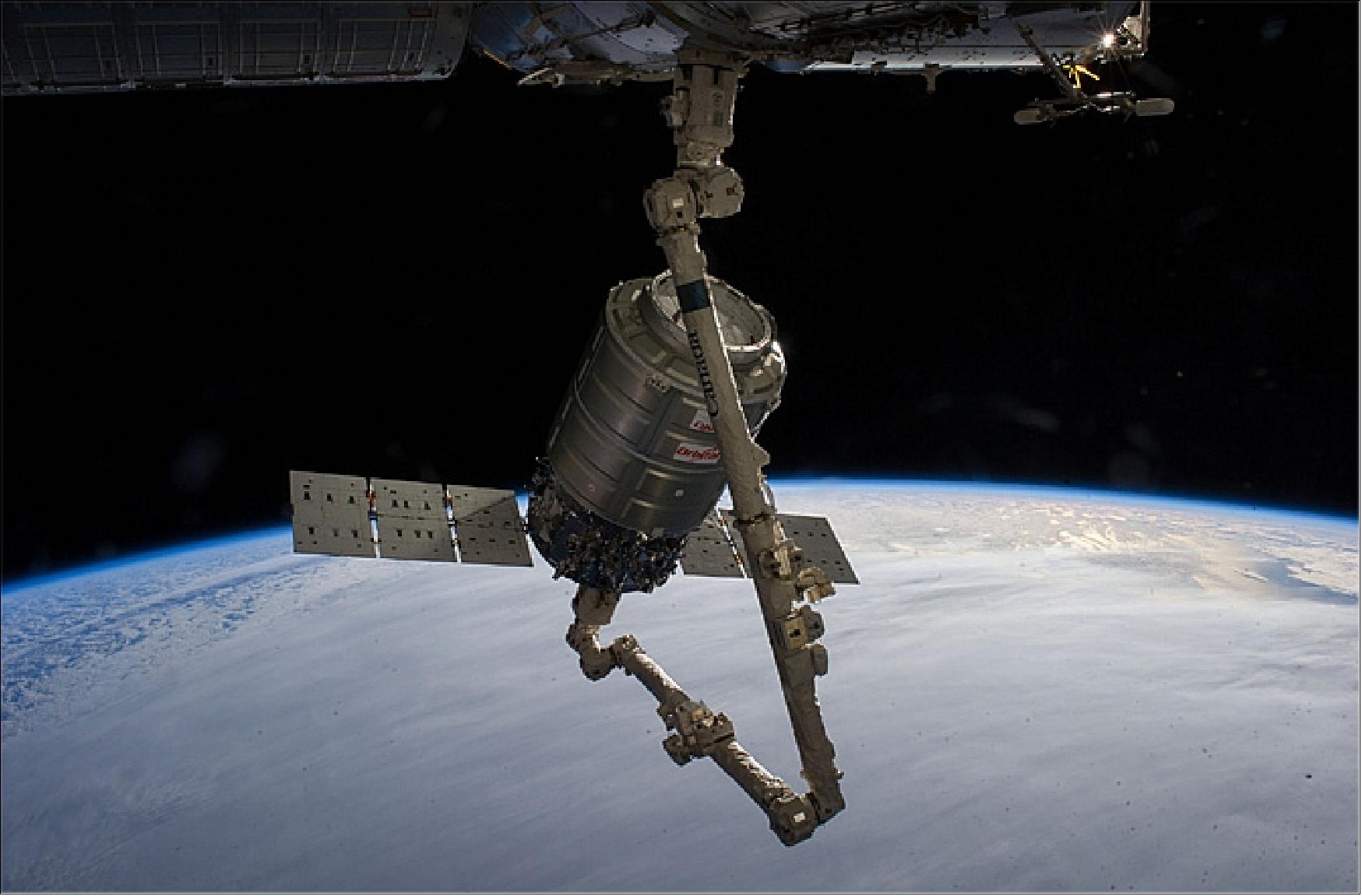
On January 12, 2014, the Cygnus CRS-1 spacecraft arrived at the ISS where Expedition 38 astronauts grappled the spacecraft and berthed it in a flawless operation (Figure 4).
Sensor Complement
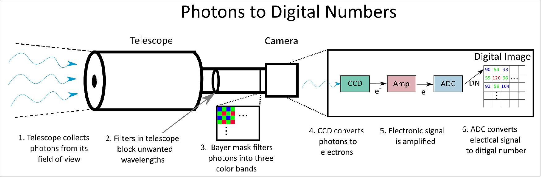
Payload design: Planet satellites each carry a telescope and a frame CCD camera equipped with Bayer-mask filter. The CCD sensor converts filtered photons into electrons, which are then amplified in order to produce a digital number corresponding to each pixel in each color band. 92)
Instruments
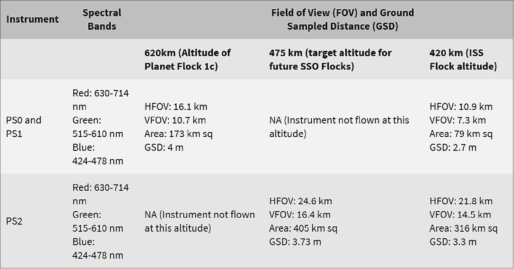
Planet has flown three generations of optical instruments: Planet Scope 0 (PS0), Planet Scope 1 (PS1), and Planet Scope 2 (PS2). Images have different attributes depending on satellite altitude and instrument type.
PS0 features a 2 element Maksutov Cassegrain optical system paired with an 11MP CCD detector. Optical elements are mounted relative to the structure of the spacecraft.
PS2 features a five element optical system that provides a wider field of view and superior image quality. This optical system is paired with a 29MP CCD detector.
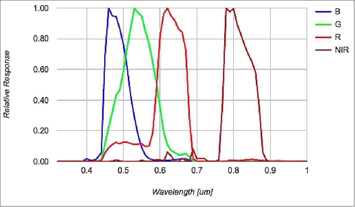
Spectral Characteristics
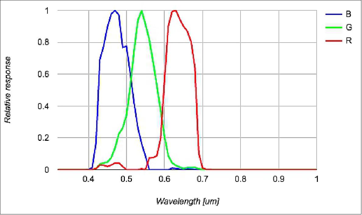
PS0 and PS1 optical systems are designed to collect data in the visible portion (red, blue and green) of the electromagnetic spectrum. The following figures show the expected RGB spectral characteristics of the PS0 and PS1 systems:
Description | International Space Station Orbit | Sun Synchronous Orbit |
Inclination | 51.6º | 98º |
Expected lifetime | 1 year per satellite; constellation is replenished over time | 2-3 years per satellite; constellation is replenished over time |
Orbital insertion altitude | 420 km | 475 km (target altitude for future SSO launches) |
Equator crossing time | Varies | 9:30-11:30am local solar time |
Sensor type | Bayer-masked CCD camera | Bayer-masked CCD camera |
Spectral bands | Red: 610-700 nm | Red: 610-700 nm |
Ground Sampling Distance | 2.7-3.2 m (nadir) | 3.7-4.9 m (nadir) |
Mission continuity | Maintain up to 55 satellite constellation (continually replenishing/upgrading satellites) | Maintain 100-150 satellite constellation (continually replenishing/upgrading satellites) |
Coverage
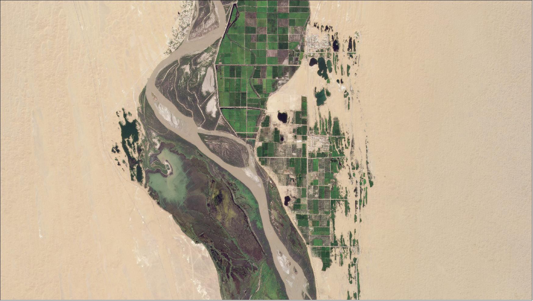
Throughout 2014 and the first half of 2016, Planet focused collection capacity on North America, Asia, and South America. Focusing on these areas allowed Planet to establish initial imagery archive to develop and refine imagery processing, imagery quality, imagery mosaic, and API capabilities.
Ground Stations and Network
Planet has developed its own global network of ground stations to support both spacecraft mission operations and image data downlink. Each ground station consists of an antenna and a Radio Frequency (RF) system, coupled with a local computer server, connected via secured VPN (Virtual Private Network) access to centralized services. Downlinked image files are transferred from local ground station servers to Planet’s cloud infrastructure for ingestion into Planet’s data processing and distribution pipeline.
The ground stations use COTS components where possible to reduce complexity and cost. In total, Planet operates equipment at 15 sites using a combination of rented equipment, co-located antenna systems, and fully independent sites. The diversity in assets allows the ground network to better scale to meet the demands of the on-orbit constellation. Relatively rapid flexibility in downlink capacity is especially important in an industry where a constellation can be built, launched, and deployed in the time needed to obtain licensing for a ground site (Ref. 6).
Nearly all Planet ground station sites include UHF radios for telemetry, tracking, and control (TT&C). These systems are used for scheduling, basic health, and ranging for orbit determination. Eight of the ground station sites also include X-band (HSD) capabilities. These eight geographically diverse sites contain a total of twenty-two dishes of varying diameters, from 4.5 meter to 7.6 meter. All dishes are designed for at least 29 dB/K G/T (Gain to noise Temperature) to optimize both the satellite downlink data rates and ground system cost.
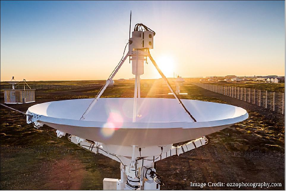
The payload data is downlinked from space at X-band, down-converted to L-band using a low noise block downconverter (LNB), and demodulated using a COTS DVB-S2 receiver. Typical ground stations passes average at 160 Mbit/s and peak at 220 Mbit/s data rates with data volumes of 12-15 GB downloaded per 7-10 minute ground station pass. The receiver deframes DVB-S2 packets, and sends raw IP frames to the ground station server via gigabit Ethernet interface. The ground station server monitors the link status (SNR, link margin, received RF power level, bit error rate), reassembles the picture files, and uploads the pictures and metrics to the cloud. Additionally, many Planet ground antenna systems have a built-in feedback loop for basic open-loop power-tracking using link statistics provided by the DVB-S2 receiver. The power tracking introduces random offsets and tests and checks the feedback look for a positive or negative response. Planet's Dove ground network is nominally autonomous and remotely monitored to enable scalability and improve operational efficiency.93) 94) Figure 27 shows the internals of Planet's S-band/X-band ground station system, and Figure 28 shows a picture of a 4.5 m diameter dish at Keflavik, Iceland.
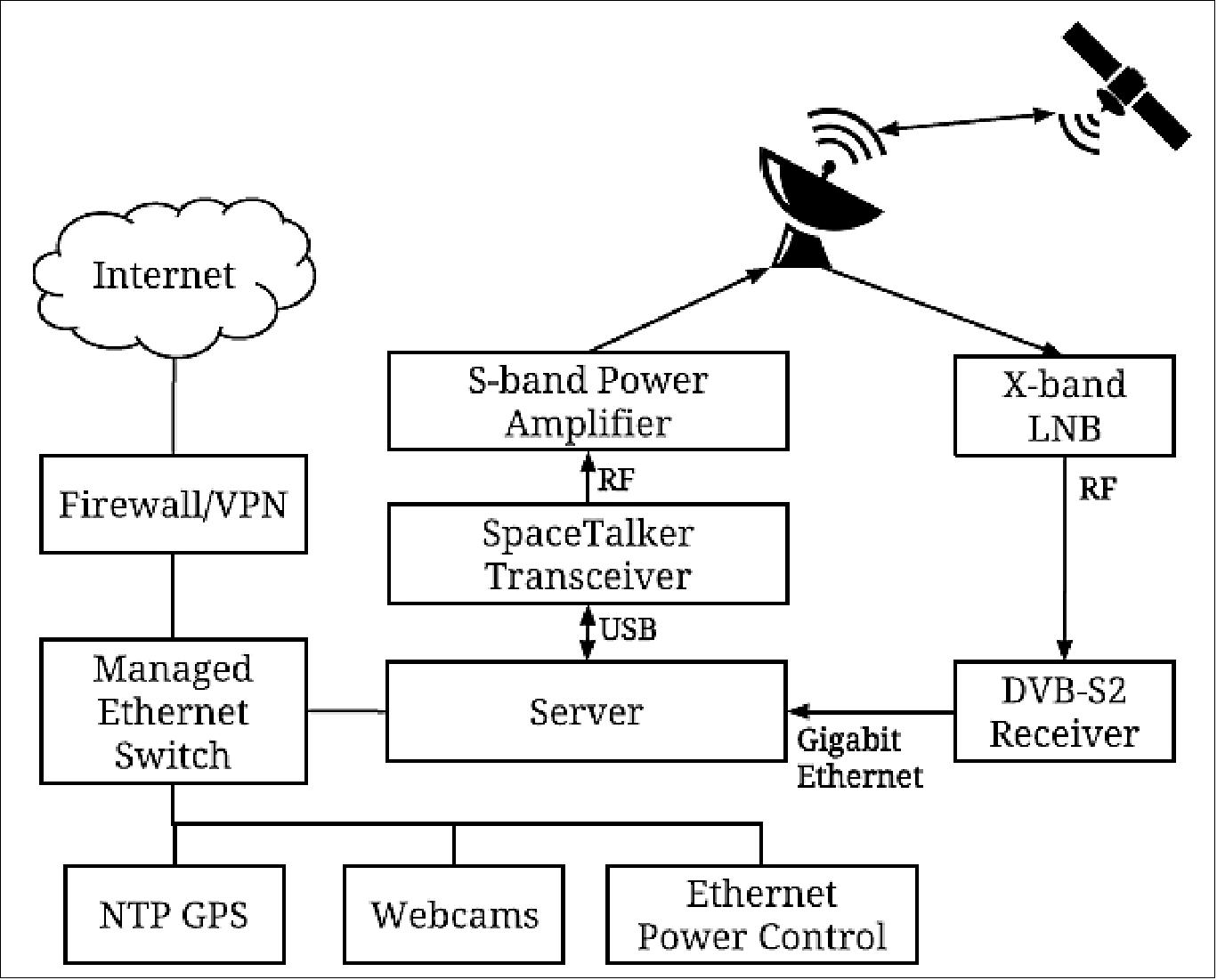
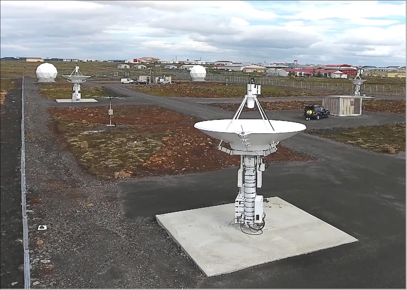
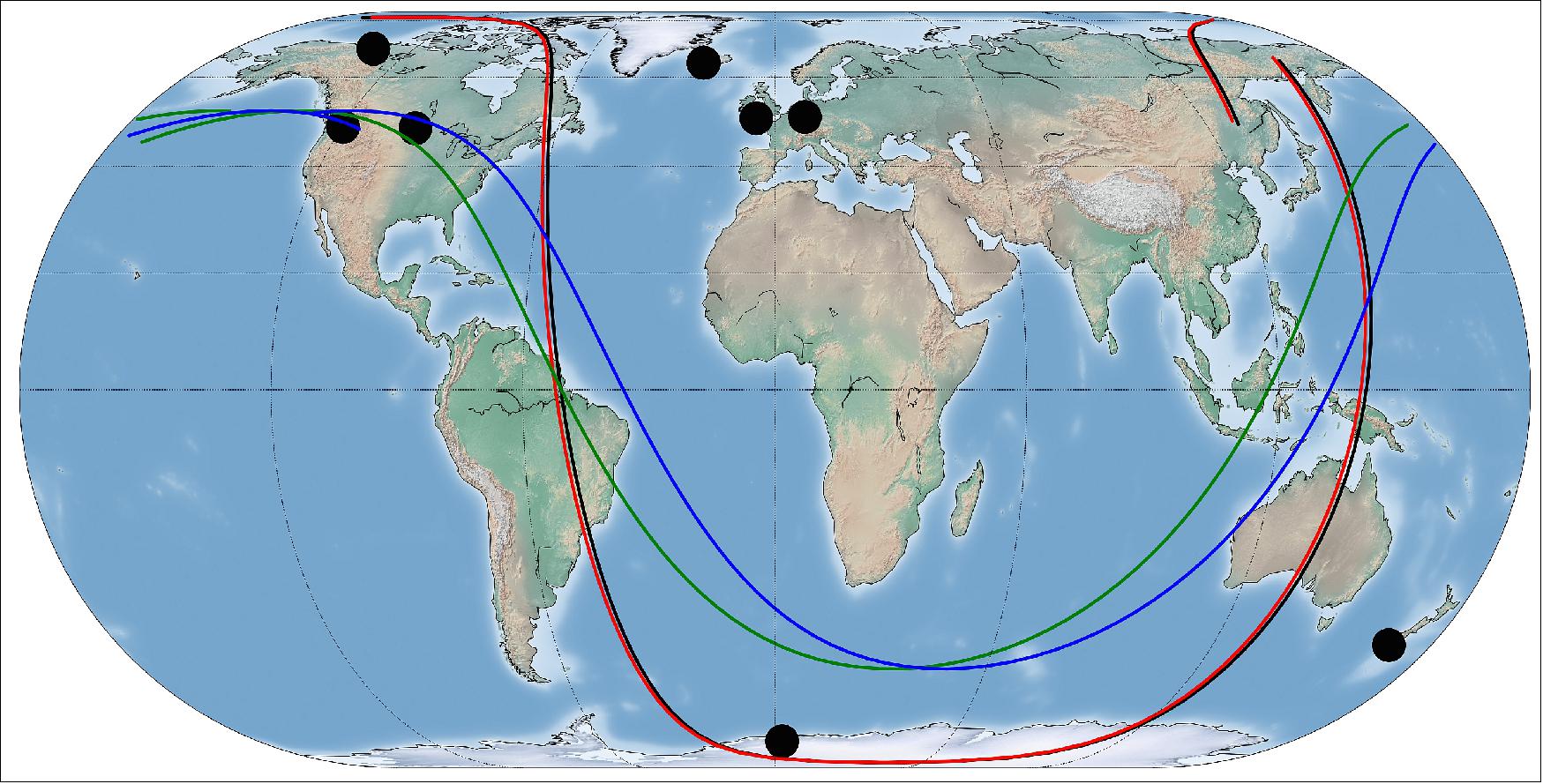
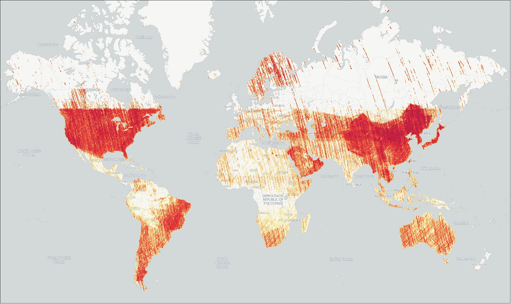
Figure 27: Location of X-band ground station antennas (black circles) and ground tracks of representative Dove satellites per flock (Flock 2P = Black, Flock 3P = Red, Flock 2E = Blue, Green), image credit: Planet Labs (Ref. 6)
- Planet's ground stations use commercial off-the-shelf (COTS) components to reduce cost and complexity, and the network's flexibility allows it to scale to meet the demands of both HSD1 and HSD2 radio systems. The ground station network underwent significant hardware and software upgrades to support the HSD2's dual polarization and multiple channels, with the addition of left-hand polarized feed and low noise block down-converter to each dish. The demodulators, demodulating data from the HSD2 transmitter, output digital data on separate interfaces, which are bonded onto a single fiber optical link using a COTS network switch. This approach maintains individual channels on a separate network, providing flexibility to change the number of channels or add more channels in the future without significantly altering the existing hardware infrastructure. Figure 14 shows the Keflavik ground station at Keflavik, Iceland, playing a key role in Planet's ground station network. The ground station scheduling software considers expected data downlinked and limits passes if needed to avoid a backlog of imagery uploads, ensuring efficient utilization of the network's capacity. 34) 35) 36) 37) 38)
Parameter | Value |
Channel Symbol Rate | 76.8 Msps |
Channel spacing, Channel bandwidth | 100 MHz, 96 MHz |
RF output power | 1 W per polarization |
Antenna polarizations | Ch 0, 1, 2: RHCP, Ch 3, 4, 5: LHCP |
Antenna gain | 15 dBi per polarization |
Radio and antenna volume | 0.25U (2.5 cm x 2.5 cm x 10 cm) |
DC power consumption | 50 W |
Modulation | QPSK, 8PSK, 16APSK, 32APSK |
Coding | 1/4 to 9/10 FEC |
Channel data rates | Variable from 37 Mbit/s to 336 Mbit/s |
Maximum data rate achieved on orbit | 1674 Mbit/s (at the time of publication) |
Parameter | Value |
Ground dish size | 4.5 m-5 m diameter |
Number of dishes | 15 |
Gain at X-band | 49 dBi |
Beamwidth (half power) | 0.55º |
G/T (gain over noise temperature) | 29 dB/K |
Cross polarization | 25 dB |
Max data downlinked per pass | 82.91 GB (at the time of publication) |
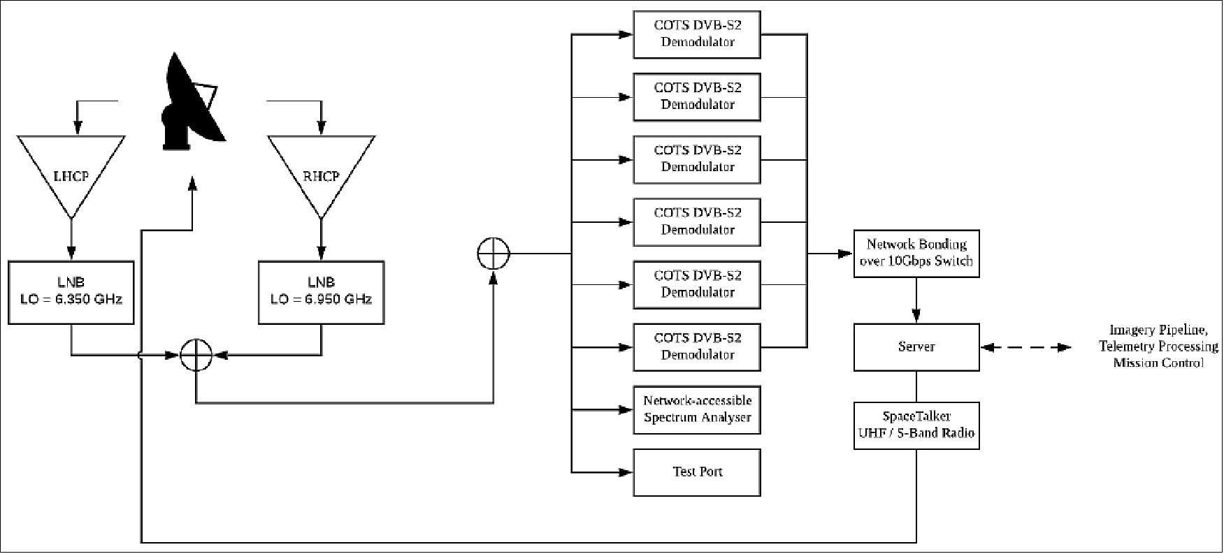
Image Pipeline
During downlink, images are temporarily buffered locally on a server co-located with the receive antenna and added to an Internet upload queue. The imagery gets uploaded to cloud storage over secured Internet connections, which kicks off a per-image processing pipeline. The local storage decouples imagery downlink from network interruptions or congestion and allows sizing the leased line for average bandwidth (as opposed to peak bandwidth or latency). The imagery is also kept stored on the satellite until the next pass so that it can be confirmed as having successfully entered the processing pipeline before being deleted.
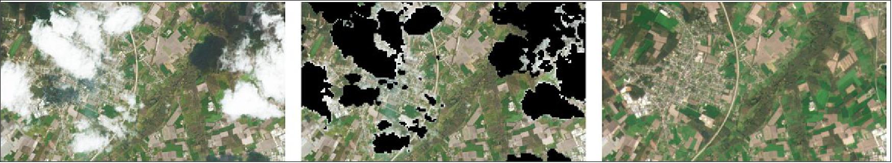
Upon ingestion, images are individually de-mosaiced (de-bayered), color-corrected, flat-fielded, and orthorectified. Orthorectification aligns the image to within 10 m (RMSE) horizontally and maps the data to a fine digital elevation model. Further analysis generates a cloud cover mask and ensures that images released to customers satisfy a series of quality metrics. During the month of May 2017, the 90th percentile of the imagery that rectified and passed quality metrics was published within 5.5 hrs of being downlinked by a ground station.
Successfully rectified images are available to customers as soon as processing has completed. To satisfy the multiple use cases of different customers, imagery is available in a variety of forms:
• Orthorectified images (\scenes", which consist of one full-frame capture) are available via REST HTTP API for customers.
• \Tiles" are produced, similar to the OSM \slippy map" architecture, on a grid that is fixed for all Planet products by rectifying and stacking the RGB and NIR bands of scenes from a single strip of imagery.
• All of the rectified imagery that meets minimum quality conditions is made available on a web-based application open to all for browsing and new imagery alerting based on user-defined areas of interest.
Data Analysis and Metrics
Planet's mission control infrastructure monitors and controls the satellites and the ground network handles over 650 HSD passes per day. Due to the large number of passes and the limited engineer time available, it is impossible to assess each pass manually. Therefore, Planet has created an automated metrics gathering and failure detection system to monitor constellation-wide high speed downlink performance.
The automated metrics system has been built using open source tools, shown in Figure 30 and runs at regular intervals. Pass relevant information, that includes information from the satellite, the ground station, and physical characteristics (orbit-related), is first consolidated. An automated pass classifier assesses the quality of the pass and identifies a possible reason for failure. The combined pass information, along with the failure diagnosis, is written to a database. A dashboard aggregates information from the passes and creates interactive visualizations. The interactive visualizations allow easy access to pass performance information to any engineer without the need to code new tools.
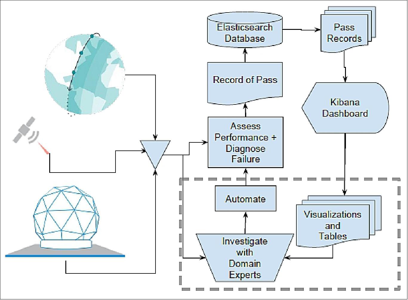
The pass classifier automates the decision making process of domain experts in order to automatically diagnose possible failure modes for sub-optimal passes. An HSD pass is considered to be a failure if the amount of image data downloaded is less than 80% of the total downlinked data volume predicted using a link budget model. The prediction uses a formula that depends on the transmitter and receiver characteristics, slant range, and orbital geometries during the pass to compute the RF link margin. Once a pass is judged to be a failed pass (which only implies sub-optimality and not an outright failure due to the conservative assumptions in the data rate predictions) the automatic classification begins.
An automated classified has been developed to classify failures. Every week, domain experts from RF and Communication Systems, Orbit Operations, Satellite Operations, System Integrations, and Ground Station Operations teams discuss, classify, and debug failed passes. After manually classifying the passes, the diagnosis is automated by creating a hierarchical tree of failures. The hierarchy of the failure mode is primarily based on the certainty with which that failure mode can be identified.
This automated approach has allowed for the classification of thousands of passes into discrete buckets with well defined problem statements. The total number of failures and the severity of the failure modes provides the direction for problem solving. Using this approach, the HSD performance was improved by ~50% from 110 Mbit/s average to 160 Mbit/s average over a few month period and pass-to-pass variance was reduced.
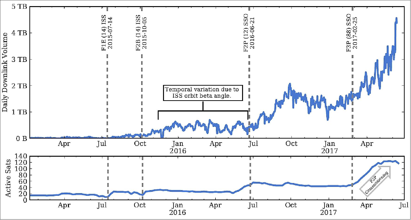
In summary, using the \agile aerospace" philosophy, Planet has rapidly prototyped and iteratively developed an end-to-end high speed satellite communication solution that not only included the development of the spacecraft and ground station hardware and software, but also the automated monitoring, scheduling, and control systems, and data metrics and analytics solutions. These co-optimized systems are tightly coupled and work together to achieve record downlink speeds of 220 Mbit/s and data volumes of over 4 TB/day. Figure 31 shows monthly aggregated historical downlink data rates and Figure 32 shows constellation wide daily downlink data volume along with the number of active satellites.
References
1) “Planet Labs Launches Two More Satellites - Delivers Largest Imaging Fleet to Launch Pad;Company’s Latest Remote-Sensing Satellites Launch from Russia,” Planet Labs Blog, Dec. 11, 2013, URL: http://blog.planet-labs.com/2013/12/11/planet-labs-launches-two-more-satellites-delivers-largest-imaging-fleet-ever-to-launch-pad-companys-latest-remote-sensing-satellites-launch-from-russia/
2) Christopher R. Boshuizen, James Mason, Pete Klupar, Shannon Spanhake, “Results from the Planet Labs Flock Constellation,” Proceedings of the AIAA/USU Conference on Small Satellites, Logan, Utah, USA, August 2-7, 2014, paper: SSC14-I-1, URL: http://digitalcommons.usu.edu
/cgi/viewcontent.cgi?article=3016&context=smallsat
3) “Planet Labs set to launch largest satellite fleet in history,” Planet Labs, Match 17, 2014, URL: http://www.planet.com/assets/themes/planet/press-releases/2014-03-17-pr.pdf
4) Quentin Hardy, Nick Bilton, “Start-Ups Aim to Conquer Space Market,” The New York Times, March 16, 2014, URL: http://www.nytimes.com/2014/03/17/
technology/start-ups-aim-to-conquer-space-market.html?_r=0
5) “Planet Labs Launches Two More Satellites - Delivers Largest Imaging Fleet to Launch Pad,” SpaceRef, Nov. 26, 2013, URL: https://web.archive.org/web/20211128142654/http://spaceref.biz/2013/11/planet-labs-launches-two-more-satellites---delivers-largest-imaging-fleet-to-launch-pad.html
6) Kiruthika Devarajy, Ryan Kingsbury, Matt Ligon, Joseph Breu, Vivek Vittaldev, Bryan Klofas, Patrick Yeon, Kyle Colton, ”Dove High Speed Downlink System,” Proceedings of the 31st Annual AIAA/USU Conference on Small Satellites, Logan UT, USA, Aug. 5-10, 2017, paper: SSC17-VII-02, URL: http://digitalcommons.usu.edu/cgi/viewcontent.cgi?article=3797&context=smallsat
7) “Planet Labs Launches Two More Satellites; Delivers Largest Imaging Fleet Ever To Launch Pad; Company’s Latest Remote-Sensing Satellites Launch from Russia,” Planet Labs, Dec. 11, 2013, URL: http://blog.planet-labs.com/2013/12/11/planet-labs-launches-two-more-satellites-delivers-largest-imaging-fleet-ever-to-launch-pad-companys-latest-remote-sensing-satellites-launch-from-russia/
8) Trent J. Perrotto, Josh Byerly, “New Science, NASA Cargo Launches to Space Station Aboard Orbital-1 Mission,” NASA, Release 14-009, URL: http://www.nasa.gov/press/2014/january/
new-science-nasa-cargo-launches-to-space-station-aboard-orbital-1-mission/#.Us98i_uFf_o
9) Laura Niles, “Largest Flock of Earth-Imaging Satellites Launch into Orbit From Space Station,” Feb. 11, 2014, URL: http://www.nasa.gov/mission_pages/station/research/news/flock_1/#.UxHvwc7ihqM
10) “SkyCube: The First Satellite Launched by You!,” Southern Stars, URL: http://www.southernstars.com/skycube/
11) ”Update: Includes Orbital ATK's Statement and Planet's Doves and SkySats Successfully Launched by Orbital ATK's Minotaur C Rocket,” Satnews Daily, 31 Oct. 2017, URL: http://www.satnews.com
/story.php?number=734611390
12) Mike Safyan, ”Planet Doubles Sub-1 Meter Imaging Capacity With Successful Launch Of 6 SkySats,” Planet, Oct. 31, 2017, URL: https://www.planet.com/pulse/tag/skysat/
13) ”Mission Update: Minotaur C SkySat Launch,” Orbital ATK, Oct. 2017, URL: https://www.orbitalatk.com
/news-room/feature-stories/MinotaurC_SkySat_Mission-Page/default.aspx?prid=283
14) Christine Flannery, ”Planet and New Light Technologies Deliver Satellite Imagery to Power Rapid Disaster Response at FEMA,” Planet Pulse News, 17 November 2021, URL:https://www.planet.com/pulse/
planet-and-new-light-technologies-deliver-satellite-imagery-to-power-rapid-disaster-response-at-fema/
15) Robbie Schlinger, ”Planet to Acquire VanderSat to Deliver Advanced Agriculture Data Products to Customers,” Planet News, 10 November 2021, URL: https://www.planet.com/pulse/
planet-to-acquire-vandersat-to-deliver-advanced-agriculture-data-products-to-customers/
16) Will Marshall, ”Planet Introduces New High Resolution Pelican Satellites and Fusion with SAR,” Planet, 12 October 2021, URL: https://www.planet.com/pulse/
planet-introduces-new-high-resolution-pelican-satellites-and-fusion-with-sar/
17) Debra Werner, ”Planet unveils Pelican Earth-imaging constellation,” SpaceNews, 12 October 2021, URL: https://spacenews.com/planet-explore-2021-pelicans/
18) ”NASA Expands Satellite Data Access for Federal Science Agencies,” NASA Feature, 23 July 2021, URL: [web source no longer available]
19) Planet to Become Publicly Traded Company through Merger with dMY IV,” Planet Press Release, 7 July 2021, URL: https://web.archive.org/web/20221206111340/https://www.planet.com/investors/press-releases/2021/planet-to-become-publicly-traded-company-through-merger-with-dmy-iv/
20) Giovanni Marchisio, ”Planet Leads RapidAI4EO Consortium to Advance Rapid and Continuous Land Monitoring,” Planet, 27 January 2021, URL: https://www.planet.com/pulse/
planet-leads-rapidai4eo-consortium-to-advance-rapid-and-continuous-land-monitoring/
21) Mike Safyan, ”48 SuperDoves Join Planet’s Constellation to Deliver Global Daily Data,” Planet, 24 January 2021, URL: https://www.planet.com/pulse/
48-superdoves-join-planets-constellation-to-deliver-global-daily-data/
22) Mike Safyan, ”Successful Launch of Flock 4e’ on Rocket Lab’s Electron,” Planet News, 28 October 2020, URL: https://www.planet.com/pulse/successful-launch-of-flock-4e-on-rocket-labs-electron/
23) Mike Safyan, ”Flock 4v’s Captivating First Light Imagery,” Planet News, 10 September 2020, URL: https://www.planet.com/pulse/flock-4v-captivating-first-light-imagery/
24) Mike Safyan, ” Planet, 3 September 2020, URL: https://www.planet.com
/pulse/arianespace-26-superdoves-vega/
25) ”Vega return to flight proves new rideshare service,” ESA Enabling & Support, 3 September 2020, URL: https://www.esa.int/Enabling_Support/Space_Transportation
/Vega/Vega_return_to_flight_proves_new_rideshare_service
26) ”With Vega, Arianespace successfully performs the first European mission to launch multiple small satellites,” Arianespace Press Release, 3 September 2020, URL: https://www.arianespace.com/
press-release/with-vega-arianespace-successfully-performs-the-first-european-mission-to-launch-multiple-small-satellites/
27) ”Vega flight VV16,” Wikipedia, URL: https://en.wikipedia.org/wiki/Vega_flight_VV16
28) Mike Safyan, ”,” Planet, 3 September 2020, URL: https://www.planet.com
/pulse/arianespace-26-superdoves-vega/
29) Mike Safyan, ”Planet’s First Launch of 2020: 26 SuperDoves on a Vega,” Planet, 13 February 2020, URL: https://www.planet.com/pulse/planets-first-launch-of-2020-26-superdoves-on-a-vega/
30) Deepthi Shankar, ”Seisan Partners with Planet to Solve Complex Business Problems Using Daily Satellite Imagery,” Planet, 24 March 2020, URL: https://www.planet.com/pulse/
seisan-partners-with-planet-to-solve-complex-business-problems-using-daily-satellite-imagery/
31) Mike Safyan, ”Planet’s First Launch of 2020: 26 SuperDoves on a Vega,” Planet, 13 February 2020, URL: https://www.planet.com/pulse/planets-first-launch-of-2020-26-superdoves-on-a-vega/
32) Mike Safyan, ”A Successful Launch for Flock 4p on the PSLV,” Planet News, 27 November 2019, URL: https://www.planet.com/pulse/a-successful-launch-for-flock-4p-on-the-pslv/
33) Deepthi Shankar, ”Introducing Planet Orbit: Planet’s New Partner Program,” Planet, 14 October 2019, URL: https://www.planet.com/pulse/introducing-planet-orbit-planets-new-partner-program/
34) Kiruthika Devarajy, Matt Ligon, Eric Blossom, Joseph Breu, Bryan Klofas, Kyle Colton, Ryan Kingsbury, ”Planet High Speed Radio: Crossing Gbps from a 3U Cubesat,” Proceedings of the 33rd Annual AIAA/USU Conference on Small Satellites, August 3-8, 2019, Logan, UT, USA, paper: SSC19{VI{01, URL: https://digitalcommons.usu.edu/cgi/viewcontent.cgi?article=4405&context=smallsat
35) Kiruthika Devaraj, Ryan Kingsbury, Matt Ligon, Joseph Breu, Vivek Vittaldev, Bryan Klofas,Patrick Yeon, Kyle Colton, ”Dove High Speed Downlink System,” Proceedings of the 31st Annual AIAA/USU Conference on Small Satellites, Logan UT, USA, Aug. 5-10, 2017, paper: SSC17–VII–02, URL: https://digitalcommons.usu.edu/cgi/viewcontent.cgi?article=3797&context=smallsat
36) Bryan Klofas, ”Planet Releases OpenLST, an Open Radio Solution,” Planet, 6 August 2018, URL: https://www.planet.com/pulse/planet-openlst-radio-solution-for-cubesats/
37) Cyrus Foster, Henry Hallam, James Mason, ”Orbit Determination and Differential-drag Control of Planet Labs Cubesat Constellations,” 10 September 2015, paper: AAS 15-524, URL: https://arxiv.org/pdf/1509.03270.pdf
38) Kyle Colton, Bryan Klofas, ”Supporting the Flock: Building a Ground Station Network for Autonomy and Reliability." Proceedings of the 30th Annual AIAA/USU SmallSat Conference, Logan UT, USA, August 6-11, 2016, paper: SSC16–IX–05, URL: https://digitalcommons.usu.edu
/cgi/viewcontent.cgi?article=3368&context=smallsat
39) ”Historic RapidEye Constellation Captures Last Light,” Planet News, 2 April 2019, URL: https://www.planet.com/pulse/historic-rapideye-constellation-captures-last-light/
40) ”NGA to leverage high-revisit Planet imagery, automated processing,” NGA Press Release, 21 March 2019, URL: https://www.nga.mil/Careers/Documents/20190320_Planet_Contract.pdf
41) ”Planet Provides Dramatic Photos of Before and After Krakatau Volcano Eruption,” Satnews Daily, 3 January 2019, URL: http://www.satnews.com/story.php?number=725847427
42) Jonathan Amos, ”Anak Krakatau volcano: Satellites get clear view of collapse,” BBC, 3 January 2019, URL: https://www.bbc.com/news/science-environment-46743362
43) Stephen Clark, ”Soyuz launches cluster of 28 satellites,” Spaceflight Now, 27 December 2018, URL: https://spaceflightnow.com/2018/12/27/soyuz-28-satellite-cluster-launch/
44) Mike Safyan, ”12 Dove Satellites Successfully Launched on Soyuz Rocket,” Planet News, 27 December 2018, URL: https://www.planet.com/pulse/category/news/
45) Stephen Clark, ”Spaceflight’s 64-satellite rideshare mission set to last five hours,” Spaceflight Now, 3 December 2018, URL: https://spaceflightnow.com/2018/12/03/
spaceflights-64-satellite-rideshare-mission-set-to-last-five-hours/
46) Mike Safyan, ”Flock 3s and 2 SkySats successfully Launch on Falcon 9 SSO-A,” Planet, 3 December 2018, URL: https://www.planet.com/pulse/five-satellites-launch-on-falcon-9-sso-a/
47) Mike Safyan, ”16 More Doves Successfully Launch on ISRO’s PSLV C-43 Rocket,” Planet News, 29 November 2018, URL: https://www.planet.com/pulse/category/news/
48) ”ISRO launches HysIS satellite, 30 others with PSLV-C43 rocket today: Everything to know ,” Indian Express, 29 November 2018, URL: https://indianexpress.com/article/technology
/science/isro-launch-hysis-satellite-30-others-pslv-c43-rocket-5469076/
49) Steve Cole, ”NASA Evaluates Commercial Small-Sat Earth Data for Science,” NASA Release 18-086, 04 October 2018, URL: https://www.nasa.gov/press-release
/nasa-evaluates-commercial-small-sat-earth-data-for-science
50) Will Marshall, ”Planet Opens New State-of-the-Art Satellite Manufacturing Factory in San Francisco,” Planet, 12 September 2018, URL: https://www.planet.com
/pulse/planet-opens-satellite-manufacturing-factory/
51) Will Marshall, ”Mission 1 Complete!,” Planet, 9 November 2017, URL: https://www.planet.com/pulse/mission-1/
52) V. Beukelaers, B. Howard, J. Mason, M. Safyan, D. Doan, J. Perera,”Completing Mission 1: Imaging Everywhere, Every Day,” Proceedings of the 4S Symposium Small Satellites Systems and Services, 28 May - 1 June 2018, Sorrento, Italy
53) Lawrence Leung, Vincent Beukelaers, Simone Chesi, Hyosang Yoon, Daniel S. Walker, Joshua Egbert, ”ADCS at Scale: Calibrating and Monitoring the Dove Constellation,” Proceedings of the 32nd Annual AIAA/USU Conference on Small Satellites, Logan UT, USA, Aug. 4-9, 2018, paper: SSC18-WKII-03, URL: https://digitalcommons.usu.edu/cgi/viewcontent.cgi?article=4239&context=smallsat
54) Will Marshall, ”Planet and Airbus Partner to Deliver New Geospatial Solutions,” Planet, 25 June 2018, URL: https://www.planet.com/pulse/airbus-partnership-geospatial-solutions/
55) ”Rocket Lab successfully reaches orbit and deploys payloads,” Rocket Lab, 21 Jan. 2018, URL: https://www.rocketlabusa.com/news/updates/
rocket-lab-successfully-reaches-orbit-and-deploys-payloads-january-21-2018/
56) ”Rocket Lab Celebrates Kiwi's Second Successful Launch with a Smile and Still Testing,” Satnews Daily, 21 Jan. 2018, URL: http://www.satnews.com/story.php?number=1575755313#
57) ”Planet to Assist Human Rights Watch with Satellite Imagery and Data,” Satnews Daily, 30 Nov. 2017, URL: http://www.satnews.com/story.php?number=1093131236
58) Mike Safyan,”Planet doubles sub-1 m imaging capacity with successful launch of 6 SkySats,” Planet, 31 Oct. 2017, URL: https://www.planet.com/pulse/
planet-doubles-sub-1-meter-imaging-capacity-with-successful-launch-of-6-skysats/
59) ”Burma: New Satellite Images Confirm Mass Destruction,” Human Rights Watch, 17 Oct. 2017, URL: https://www.hrw.org/news/2017/10/17/burma-new-satellite-images-confirm-mass-destruction
60) Rob Zimmerman, Deanna Doan, Lawrence Leung, James Mason, Nate Parsons, Kam Shahid, ”Commissioning the World’s Largest Satellite Constellation,” Proceedings of the 31st Annual AIAA/USU Conference on Small Satellites, Logan UT, USA, Aug. 5-10, 2017, paper: SSC17-X-03, URL: http://digitalcommons.usu.edu/cgi/viewcontent.cgi?article=3669&context=smallsat
61) Ricardo Rios-Olmo, Martin Miller, ”Planet’s Open Water Imaging - Geo-Accuracy Assessment,” Proceedings of the 31st Annual AIAA/USU Conference on Small Satellites, Logan UT, USA, Aug. 5-10, 2017, paper: SSC17-I-07, URL: http://digitalcommons.usu.edu
/cgi/viewcontent.cgi?article=3598&context=smallsat
62) Caleb Henry, ”Planet wins second NGA satellite-imagery contract,” 20 July 2017, URL: http://spacenews.com/planet-wins-second-nga-satellite-imagery-contract/
63) ”Planet Joins With Geological Remote Sensing Group,” Satnews Daily, May 3, 2017, URL: http://www.satnews.com/story.php?number=761128932
64) Jeff Foust, ”Planet confirms Google stake as Terra Bella deal closes,” Space News, April 19, 2017, URL: http://spacenews.com/planet-confirms-google-stake-as-terra-bella-deal-closes/
65) ”Timbuktu,” Planet, March 5, 2017, URL: https://www.planet.com/gallery/#!/post/timbuktu-20170305
66) Markus Strauss, ”Flotilla of tiny satellites will photograph the entire Earth every day,” Science Magazine, Feb. 23, 2017, URL: http://www.sciencemag.org/news/2017/
02/flotilla-tiny-satellites-will-photograph-entire-earth-every-day
67) Robbie Schingler, Will Marchall, ”Planet Launches Satellite Constellation to Image the Whole Planet Daily,” Planet News, February 14, 2017, URL: https://www.planet.com/pulse
/planet-launches-satellite-constellation-to-image-the-whole-planet-daily/
68) ”PSLV-C37 / CartoSat -2 Series Satellite,” ISRO, Feb. 15, 2017, URL: http://www.isro.gov.in/launcher/pslv-c37-cartosat-2-series-satellite
69) Stephen Clark, ”India lofts a record 104 spacecraft on a single rocket,” Spaceflight Now, Feb. 15, 2017, URL: http://spaceflightnow.com/2017/02/15/india-lofts-a-record-104-spacecraft-on-a-single-rocket/
70) Gallery of Planet, accessed on March 1, 2017, URL: https://web.archive.org/web/20170303200541/https://www.planet.com/gallery/san-francisco-20170211/
71) Marc Selinger, ”Satellite Today, Sept. 28, 2016, URL: http://www.satellitetoday.com
/nextspace/2016/09/28/nga-growing-acceptance-satellite-imagery-startups/
72) ”SmallSats In The White House — Harnessing the Small Satellite Revolution to Promote Innovation and Entrepreneurship in Space ,” Satnews Daily, Oct. 24, 2016, URL: http://www.satnews.com
/story.php?number=1949829205
73) ”Yukon River Canada,” Planet Labs, Sept. 19, 2016, URL: https://web.archive.org/web/20161205014212/https://www.planet.com/gallery/yukon-20160919/
74) ”Great Barrier Reef, Australia,” eoPortal team, July 14, 2016, URL: https://commons.wikimedia.org/wiki/File:Great_Barrier_Reef,_Australia_by_Planet_Labs.jpg
75) Planet Labs, Inc., CC BY-SA 4.0, URL: https://commons.wikimedia.org/wiki/File:Nazca_Lines,_Peru_by_Planet_Labs.jpg
76) ”Nazca Lines, Peru 2016-06-08,” Planet Labs, June 2016, URL: https://web.archive.org/web/20161204220029/https://www.planet.com/gallery/nazca-lines/
77) ”Our Planet - A collection of our favorite images and insights from around the planet,” Planet Labs, April 14, 2016, URL: https://web.archive.org/web/20161205080751/https://www.planet.com/gallery/lake-saint-pierre/
78) ”Icy Sumy Oblast, Ukraine,” Planet Labs, Inc., CC BY-NC 2.0, URL: https://api.planet.com/gallery/v1/posts/sumy-oblast
79) ”Our Planet: A collection of our favorite images and insights from around the planet,” Planet Labs, Oct. 26, 2015, URL: [web source no longer available]
80) ”BlackBridge is Now Part of The Planet Labs Family,” BlackBridge, Oct. 15, 2015, URL: http://blackbridge.com/planet/
81) Our Planet - A collection of our favorite images and insights from around the planet,” Planet Labs, March 1, 2015, URL: https://web.archive.org/web/20150627163138/https://www.planet.com/gallery/korea-aquaculture/
82) Rachel Holms, “A Look Back: Planet’s Progress in 2014,” January 11, 2015, URL: https://www.planet.com/pulse/a-look-back-planets-progress-in-2014/
83) “NanoRacks Completes Historic Third Round of ISS CubeSat Deployments,” Space Daily, March 11, 2015, URL: http://www.spacedaily.com/reports/
NanoRacks_Completes_Historic_Third_Round_of_ISS_CubeSat_Deployments_999.html
84) https://web.archive.org/web/20150627101659/https://www.planet.com/gallery/kangbashi-new-area/
85) https://www.exutopia.com/welcome-to-ordos-world-largest-ghost-city-china/
86) Chris Boshuizen, “Results from Flock 1,” URL: http://digitalcommons.usu.edu
/cgi/viewcontent.cgi?filename=0&article=3016&context=smallsat&type=additional
87) “Planet Labs Strikes Agreement with Wilbur-Ellis to Enhance AgVerdict® Data Tool,” Feb. 2, 2015, URL: https://www.planet.com/pulse/
88) Elizabeth Howell, “When Doves Fly: Swarm Of Tiny Satellites Shot From Space Station,” Universe Today, Feb. 13, 2014, URL: http://www.universetoday.com
/109317/when-doves-fly-swarm-of-tiny-satellites-shot-from-space-station/
89) Patrick Blau, “Flock-1 CubeSat Constellation begins Deployment from Space Station,” Spaceflight 101, Feb. 11, 2014, URL: http://www.spaceflight101.com/
flock-1-cubesat-constellation-begins-deployment-from-iss.html
90) “Saving the Planet One Tiny Satellite at a Time,” Discovery Channel, Jan. 16, 2014, URL: http://news.discovery.com/space/
private-spaceflight/saving-the-planet-one-tiny-satellite-at-a-time-140116.htm
91) “FCC Clears Planet Labs to Proliferate,” EIJ (Earth Imaing Journal), Nov. 2014, URL: http://eijournal.com/industry-insights-trends/planet-labs-has-been-cleared-to-proliferate
92) ”Planet Spacecraft Operations and Ground Control,” Version 1.2 , Last updated September 2015, Planet, URL: https://www.planet.com/docs/spec-sheets/spacecraft-ops/
93) Bryan Klofas, ”Planet Labs Ground Station Network,” 13th Annual CubeSat Developers Workshop Cal Poly SLO, April 21, 2016, URL: http://mstl.atl.calpoly.edu/~workshop/archive/2016/Spring/Day%202/Session%204/1_BryanKlofas.pdf
94) Kyle Colton, Bryan Klofas,”Supporting the Flock: Building a Ground Station Network for Autonomy and Reliability." Proceedings of the 30th Annual AIAA/USU SmallSat Conference, Logan UT, USA, August 6-11, 2016, paper: SSC16-IX-05, URL: http://digitalcommons.usu.edu
/cgi/viewcontent.cgi?article=3368&context=smallsat
95) SatNews, “Planet’s 1st Pelican tech demo sat plus 36 SuperDoves launch via SpaceX”, November 12, 2023, URL: https://news.satnews.com/2023/11/12/planets-1st-pelican-tech-demo-sat-plus-36-superdoves-launch-via-spacex/
96) Gunter’s Space Page, “Flock-1, -1b, -1c, -1d, -1d', -1e, -1f, -2b, -2e, -2e', -2k, -2p, -3m, -3p, -3p', -3r, -3s, -4a, -4e, -4e', -4p, -4q, -4s, -4v, -4x, -4y”, URL: https://space.skyrocket.de/doc_sdat/flock-1.htm
97) Wikipedia, “Planet Labs”, URL: https://en.wikipedia.org/wiki/Planet_Labs
The information compiled and edited in this article was provided by Herbert J. Kramer from his documentation of: ”Observation of the Earth and Its Environment: Survey of Missions and Sensors” (Springer Verlag) as well as many other sources after the publication of the 4th edition in 2002. - Comments and corrections to this article are always welcome for further updates (eoportal@symbios.space).