ROSE-L (Radar Observing System for Europe in L-band)
EO
ESA
Approved
Gravity and Magnetic Fields
Radar Observing System for Europe in L-band (ROSE-L) is an Earth observing synthetic aperture radar (SAR) mission, being developed by the European Space Agency (ESA). ROSE-L aims to monitor geohazards, observe and track land use, agriculture and forestry, provide high resolution soil moisture data, and monitor the Arctic and cryosphere.
Quick facts
Overview
| Mission type | EO |
| Agency | ESA, COM |
| Mission status | Approved |
| Measurement domain | Gravity and Magnetic Fields |
| Measurement category | Gravity, Magnetic and Geodynamic measurements |
| Measurement detailed | Crustal plates positioning |
| Instruments | L-band SAR |
| Instrument type | Imaging microwave radars |
| CEOS EO Handbook | See ROSE-L (Radar Observing System for Europe in L-band) summary |
Summary
Mission Capabilities
ROSE-L will carry a single instrument, the ROSE-L SAR, an L-band synthetic aperture radar (SAR). ROSE-L SAR is a high-resolution, multi-purpose and all-weather imager that aims to support existing Copernicus C-band SAR systems. It will also enhance imaging capabilities in areas of heavy vegetation coverage where its longer wavelength L-band radio is able to penetrate the canopy.
Performance Specifications
ROSE-L has a spatial resolution of 5 - 10 m for geohazard monitoring, and a revisit time of three or six days, depending on its operating mode. As well as this, it can generate volumetric soil moisture products, with a spatial resolution of 25 m2 when imaging on a regional scale, and a resolution of 50 m2 on a global scale. ROSE-L can also generate geospatial maps of sea ice development, at a resolution of 20 m.
ROSE-L is planned to operate in a sun-synchronous orbit of 693 km.
Space and Hardware Components
The ROSE-L SAR will be constructed by Airbus, while the majority of subsystem components will be provided by Thales Alenia Space. The ROSE-L satellite bus will be three-axis stabilised, based on the new Multi-Mission Production Line (MILA) of Thales Alenia Space, and will have a seven and a half year design life. The bus will house a set of three cameras (CAM), to monitor antenna and solar array deployment, the Power Control and Distribution Unit (PCDU), the Solar array Photovoltaic Assembly (PVA) before deployment, as well as the Ka-band transmission unit, S-band transponder and star trackers.
Overview
ROSE-L (Radar Observing System for Europe in L-band) is an earth observation mission in the framework of ESA's Copernicus program. Six series of so-called Sentinel satellites ensure continuity until 2026-2028 (First Generation). The “CSC (CopernicusSpacecraft) Expansion” program includes the new missions that have been identified by the European Commission (EC) as priorities for implementation in the coming years. Among the new missions presently under preliminary design phase, the Copernicus L-band SAR will support key European policy objectives through the filling of observation gaps in the current Copernicus satellite constellation and will provide enhanced continuity for diverse operational services, supporting the down-stream commercial and institutional users. The mission is presently named ROSE-L (Radar Observing System for Europe in L-band), to indicate its capability to work in synergy with other Copernicus SAR-based space elements operating at a different frequency (particularly Sentinel-1 operating at C-band) as an element of a System of Systems (SOS). 1)
In the frame of the work carried out to preliminarily design the system, the ESA Mission Advisory Group (MAG) helps to advise on the mission requirements. The requirements are mainly inspired by the Copernicus service needs that are being collected by the MAG looking at previous studies, at the EC Copernicus Service evolution document, as well as at the outcome of specialised workshops in diverse application fields. Due to the longer wavelength and enhanced penetration capabilities, L-band SAR observations from space provide additional information that cannot be gathered by other means, for instance on volumetric targets (e.g., vegetation, forest, ice), or moisture content. ROSE-L is capable of addressing important measurement gaps from space, leveraging unique information on land, disasters and geohazards and the cryosphere.
This includes the collection of ground motion and high-resolution soil moisture information on vegetated areas, the provision of vegetation biomass data, and improved land cover. The quantification of the vegetation scattering contribution is another key factor to ensure a better coherence of the signal for interferometric applications. The unique interaction mechanisms of L-band longer wavelength will also bring additional information when exploiting multifrequency datasets, e.g., for sea ice observations. Being an element of a complex mission system, ROSE-L will support the overall continuity of the Copernicus observations, e.g., improving their accuracy, the products quality, the temporal and spatial resolution of collected data.
Spacecraft
Airbus has been selected by Thales Alenia Space to build the advanced radar instrument for the ROSE-L (Radar Observatory System for Europe in L-band) mission. Airbus Defence and Space in Friedrichshafen (Germany) will head an industrial consortium for the radar instrument involving companies from nine countries to deliver the project. The contract, awarded to Airbus by the mission's Prime contractor Thales Alenia Space, is worth about € 190 million. 2)
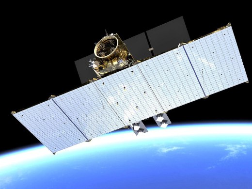
The Copernicus ROSE-L spacecraft will carry an active phased array synthetic aperture radar instrument. From its 690 km polar orbit ROSE-L will provide day-and-night monitoring of land, oceans and ice offering more frequent imaging at high spatial resolution and sensitivity. It will use advanced radar techniques including polarimetry and interferometry to create its data products. The radar antenna will be the largest planar antenna ever built measuring an impressive 11 metres by 3.6 metres; this is roughly the size of 10 ping-pong tables.
During its 7.5 year lifetime, the ROSE-L mission will serve the needs of many users including the European Union’s Copernicus Land Monitoring and Emergency Management services. It will provide important data on soil moisture, precision farming, food security, forest biomass and changes to land use. In addition, the mission will monitor polar ice sheets and ice caps, sea ice extent, and snow cover.
“The selection of Airbus to design this complex radar payload is a tribute to Airbus’ world leadership in space radar technology,” said Jean-Marc Nasr, head of Space Systems at Airbus. “Earth is surely the best and probably the only viable option for mankind. So we need to take good care of it. Our radar will enable the ROSE-L mission to do just that, helping to understand climate change and support sustainable ecological transition. This Copernicus new generation satellite is an enabler for the European Green Deal and Airbus is proud to be playing its part.”
Overall, Airbus is responsible for the spacecraft or payload on 3 of the 6 new generation Copernicus Environment and Earth observation missions: LSTM, CRISTAL and ROSE-L, and is providing critical equipment to all six.
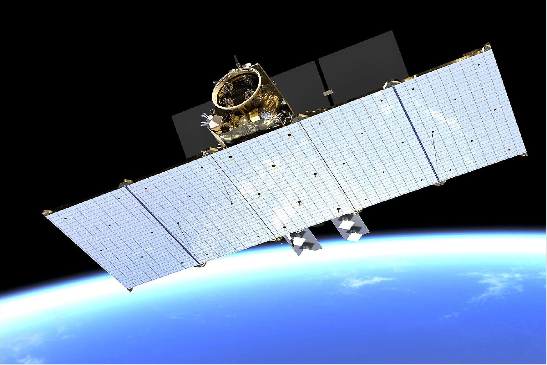
ROSE-L is a 3 axis stabilised satellite based on the new Thales Alenia Space Multi-Mission Platform product line (MILA) and will embark the L-band Synthetic Aperture Radar (SAR) instrument dedicated to the day-and-night monitoring of land, ice and oceans offering improved revisit time, full polarimetry, high spatial resolution, high sensitivity, low ambiguity ratios and capability for repeat-pass and single-pass cross-track interferometry. It is based on a 5-panel deployable 11 m x 3.6 m L-band, highly innovative and lightweight planar Phased Array Antenna (PAA). The satellite will also carry a set of 3 Monitoring Cameras (CAM) to monitor the deployment of the SAR antenna and the solar arrays. 3)
Industrial contributions: Thales Alenia Space in Belgium will provide the Power Control and Distribution Unit (PCDU) and the Solar array Photovoltaic Assembly (PVA) , Thales Alenia Space in Switzerland the monitoring camera, Thales Alenia Space in Spain the Ka-band Transmission Assembly, the Remote Interface Unit (RIU) and the S-band Transponder. Leonardo will provide the Star Trackers.
Launch
ROSE-L will operate in a sun-synchronous orbit with an altitude of 693 km.
Mission Status
• July 21, 2023: The ROSE-L SAR instrument was undergoing testing and activities, as part of its ‘Phase C’ development. 10)
• April 1, 2022: As part of the Copernicus expansion, ESA has undertaken the development of the L-band Synthetic Aperture Radar (SAR) Mission, referred to as Radar Observing System for Europe (ROSE-L). This mission, which includes a constellation of two satellites, will systematically acquire and provide routine data and information products for the Copernicus Marine, Land, Climate Change and Emergency services, as well as to the recently proposed Copernicus Land Motion service. 4) The envisioned acquisition of co-located ROSE-L and C-band Sentinel-1 SAR data within a short time interval, providing quasi multi-frequency imagery, will improve the classification of sea-ice types and the estimation of sea-ice drift, respectively. The ROSE-L mission will provide repeat-pass SAR interferometry (InSAR) capability for each ROSE-L satellite.
• December 9, 2021: SPACEBEL had recently secured a contract to develop and deliver the Control Application Software for the instrument of the Radar Observing System for Europe in L-band (ROSE-L), a new Earth observation satellite to join the European Copernicus constellation. 5) The control software for the ROSE-L payload, a Synthetic Aperture Radar (SAR), will collect and transfer the raw data from the instrument for analysis on the ground. It will also configure, control and manage the instrument jointly with the ground segment. The agreement signed with Airbus Defence and Space Ltd (Portsmouth, UK), who is in charge of the satellite payload, also covers the Software Validation Facility, i.e. the test system to check on the ground whether the software meets all specifications and is performing correctly in order to achieve its intended purpose.
- The ROSE-L spacecraft would complement the current Copernicus Sentinel-1 mission radar capabilities for land management and ocean monitoring. Its innovative instrument, a lightweight L-band Synthetic Aperture Radar (SAR), which can penetrate through many natural materials such as vegetation, dry snow and ice, has a 260 km swath width. Moreover, with its 11m x 3,6m size, the 5-panel deployable antenna will be the largest planar radar antenna ever built for Space applications. ROSE-L is one of the six second generation Copernicus satellites, the so-called High Priority Candidate Missions, meant to sustain, replace and enhance the current Sentinels in order to address policy priorities and engagements of the European Union in terms of environmental monitoring and protection, climate monitoring and natural disaster assessment.
• December 3, 2020: ESA and Thales Alenia Space (TAS) have today signed a contract to develop the new high-priority Copernicus Radar Observation System for Europe in L-band (ROSE-L) environmental monitoring mission – as part of Europe’s Copernicus program. The contract was signed in the presence of Riccardo Fraccaro, Undersecretary of the Italian Prime Minister’s Office, and ESA’s Director General, Jan Wörner. 6). ROSE-L will provide continuous day-and-night all-weather monitoring of Earth’s land, oceans and ice, and offer frequent images at a high spatial resolution.
- During its 7.5-year lifetime it would deliver essential information on forests and land cover, leading to improved monitoring of the terrestrial carbon cycle and carbon accounting. The mission would also greatly extend the ability to monitor minute surface displacements and help detect geohazards. It will automatically map surface soil moisture conditions and monitor sea and land ice, greatly helping climate change research and mitigation. From its 690 km polar orbit, ROSE-L would carry an active phased array synthetic aperture radar instrument. The radar antenna will be the largest planar antenna ever built measuring an impressive 11 m by 3.6 m – roughly the size of 10 ping-pong tables. With a contract secured worth €482 million, Thales Alenia Space in Italy is the prime contractor for the mission, with Airbus Defence and Space in Germany responsible for the radar instrument. The industrial team includes 29 companies (including 15 SME’s) from 15 countries.
Sensor Complement
ROSE-L will carry a single instrument, bearing the same name as the mission, ROSE-L (Radar Observing System for Europe in L-band). The ROSE-L instrument has five main goals: To fill information gaps in the monitoring of geohazards by including vegetated areas in the collection of ground motion information, to provide enhanced monitoring of land use, forestry and agriculture by improving mapping leveraging, to enable high resolution monitoring of soil moisture below vegetation canopies, to provide enhanced monitoring of the Arctic and the cryosphere and to improve maritime surveillance capabilities. ROSE-L is uniquely suited to geohazard monitoring due to its use of L-b and in taking SAR observations. The longer wavelength provided by L-band allows penetration through vegetation coverage, meaning the ROSE-L is capable of providing ground motion information for previously inaccessible areas, at a spatial resolution of 5 m - 10 m with a revisit time of three or six days. This capability will address both the current and future requirements of the European Ground Motion Service (EGMS) which is now part of the Copernicus Land Monitoring Service’s product portfolio. With regards to forestry, ROSE-L SAR will be used for distinction between vegetated and non-vegetated areas, analysis of broad forest types, and, with time series of data, tracking of disturbances and changes in forest cover. ROSE-L will be particularly valuable in areas often under cloud cover, as its L-band SAR is able to penetrate such barriers, whereas other optical instruments cannot.
ROSE-L also has applications in soil moisture measurement, allowing generation of volumetric soil moisture (%) products, on both a regional and a global scale, with a spatial resolution of 25 m2 for regional coverage and 50 m2 for global coverage, and a revisit time of three days for both regional and global coverage. In terms of Arctic and cryosphere measurements, ROSE-L generates geospatial maps of sea ice development at a spatial resolution of 20 m and revisit frequency of one day, allowing determination of sea ice type, concentration and motion. As well as this, it is capable of measuring glacier and ice cap surface velocity, producing motion vectors with a spatial resolution of 10 m and a revisit time of six days. ROSE-L data is also applicable to a number of secondary objectives, including the extent and properties of permafrost, such as the vertical movement of ground due to permafrost, for which the L-band SAR is more effective than C-band models, especially in areas with obscuring vegetation. As well as this, ROSE-L can be used for determination of land topography beneath vegetation, due to the longer wavelength of L-band radar, and glacier and ice cap subsurface mapping. The ROSE-L mission will systematically acquire and provide data and information products for the Copernicus Marine, Land, Climate Change and Emergency services, as well as to the recently proposed Copernicus Land Motion service. As well as this, in acquiring co-located ROSE-L and C-band Sentinel-1 SAR data, will provide multi-frequency imagery to improve the classification of sea ice types and the estimation of sea ice drift.
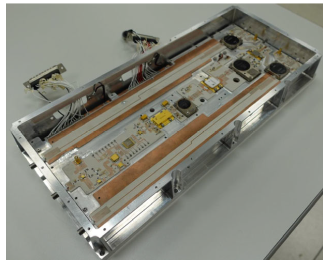
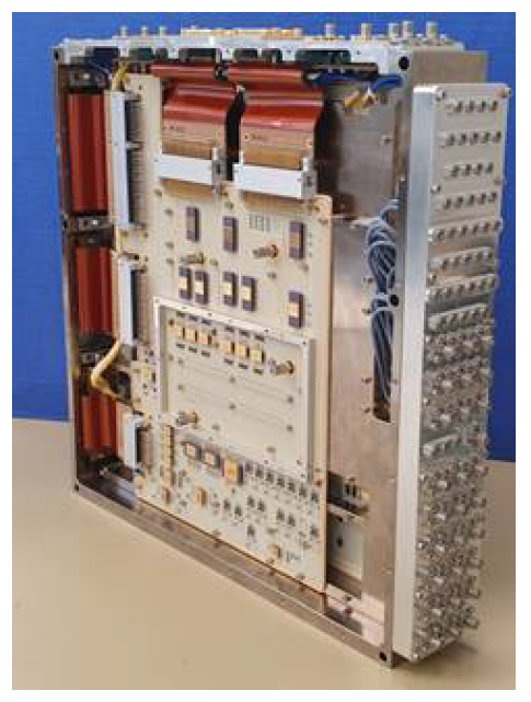
ROSE-L SAR Instrument Architecture
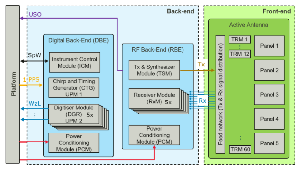
The SAR instrument architecture is split into the front-end and back-end (see Figure 2 above). The Back-End is further split into a digital section (DBE), a radio frequency (RBE) section and a Redundancy Switch Assembly (RSA).
Digital Back-End (DBE)
The DBE includes the Instrument Control Module (ICM), the Chirp and Timing Generator (CTG), the Digitiser Modules (DGR) and the Power Conditioning Modules (PCM).
The ICM interfaces with the platform and implements the instrument command and control, white the CTG is in charge of generating and transmitting the chirp signal, instrument timing & control, antenna control and monitoring, control and synchronisation of five nominal (out of 6) Digitiser modules.
The DGR are in charge of the digital conversion of the radar echoes, the digital beamforming, SCan On Receive, decimation, data compression, packetization and the PCM, are in charge of powering the digital back-end modules and a radio frequency section (including the Transmit and Synthesizer Module, the Receiver Modules and the Power Condition Modules). 9)
Radio Frequency Back-End (RBE)
The RBE includes the Transmit and Synthesizer Module (TSM), which is in charge of conditioning and amplifying the transmit chirp provided as input from the CTG, hosting and distributing the instrument Ultra Stable Oscillator, and the Receiver Module (RXM), which is in charge of conditioning the radar echoes prior to injecting them in the DGRs.
A Redundancy Switch Assembly (RSA, not shown in Figure 2) is implemented as a set of electromechanical coaxial switches in charge of re-routing the received SAR echoes to the redundant back-end modules in case of failure (a 5 out of 6 redundancy concept is applied for the RXMs and DGRs).
Front-End
The instrument front-end includes the Active Antenna Panels, the Transmit Receive Modules (TRMs), the Radio Frequency Distribution Network (RFDN) and the Mechanisms.
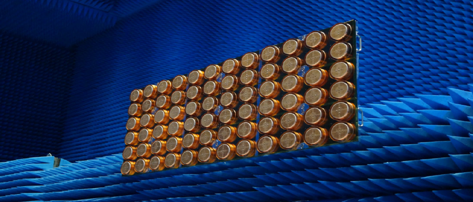
The Active Antenna Panels are 2.2m x 3.6m antenna panels with 12 subarrays in elevation direction each. The full antenna is made up of 5 antenna panels in the along track/azimuth direction, for a total antenna dimension of 11m x 3.6m. Once deployed, this antenna will be one of the largest in space.
The TRMs are in charge of amplifying the chirp provided by the TSM, as well as receiving the radar echoes from the antenna. A total of 60 dual-polarisation TRMs are present in the instrument (one TRM per antenna subarray).
The RFDN is a set of cables and divider/combiners used to route the RF signal from/to the instrument back-end, to/from the Instrument front-end and within the Instrument front-end itself and the Mechanisms, are in charge of the SAR antenna deployment after launch.
ROSE-L SAR Key Technologies and Techniques
To fulfil the instrument performance, specific technologies and techniques are used in the ROSE-L instrument.
The main key element used is Digital beamforming, which is implemented both on-board in real time and on the ground in the data processor. The on-board beamforming is performed in the elevation direction (Scan ON Receive (SCORE)) for maximising instrument sensitivity and minimising range ambiguities over the large ROSE-L swath. Meanwhile, the data processor beamforming is done in the azimuth direction to allow for simultaneous high azimuth resolution and large swath width.
Other key elements included are high power (>150W peak power) TRMs, using one of the largest SAR antennas ever flown, cutting edge digital electronics (based on the Airbus Universal Processing Module Programme), demanding power and thermal management, low mass technologies, on-board and on-ground mitigation techniques for ionospheric effects and on-ground radio frequency interferences mitigation algorithms.
References
1) Nazzareno Pierdicca, Malcolm Davidson, Marco Chini, Wolfgang Dierking, Samuel Djavidnia, Joerg Haarpaintner, Guillaume Hajduch, Gaia V. Laurin, Marco Lavalle, Carlos López-Martínez, Thomas Nagler, and Bob Su "The Copernicus L-band SAR mission ROSE-L (Radar Observing System for Europe) (Conference Presentation),",Proceedings of. SPIE 11154, 'Active and Passive Microwave Remote Sensing for Environmental Monitoring III,' 111540E, 18 October 2019, SPIE Remote Sensing 2019, Strasbourg, France, https://doi.org/10.1117/12.2534743
2) ”Airbus to deliver radar instrument for new Copernicus ROSE-L mission,” Airbus Press Release, 3 December 2020, URL: https://www.airbus.com/en/newsroom/press-releases/2020-12-airbus-to-deliver-radar-instrument-for-new-copernicus-rose-l
3) ”Thales Alenia Space signs contract from ESA to build Copernicus ROSE-L satellite,” Thales Group, 3 December 2020, URL: https://www.thalesgroup.com/en/worldwide/space/press-release/thales-alenia-space-signs-contract-esa-build-copernicus-rose-l
4) Status of the current and future ESA Earth Observation Missions and Programmes, — ROSE-L: L-band Synthetic Aperture Radar,” ESA, 1 April 2022, URL: https://forum.nasaspaceflight.com/index.php?action=dlattach;topic=6114.0;attach=2055430
5) ”The New Copernicus ROSE-L Satellite Will Carry SPACEBEL Software,” SpaceBel News, 9 December 2021, URL: https://spacebel.com/news/the_new_copernicus_rose-l_satellite_will_carry_spacebel_software/14
6) ”Contract signed for new Copernicus ROSE-L mission,” ESA Applications, 3 December 2020, URL: https://www.esa.int/Applications/Observing_the_Earth/Copernicus/Contract_signed_for_new_Copernicus_ROSE-L_mission
7) ESA. Copernicus L-band SAR Mission Requirements Document, ESA, 10 October 2018, https://esamultimedia.esa.int/docs/EarthObservation/Copernicus_L-band_SAR_mission_ROSE-L_MRD_v2.0_issued.pdf.
8) German Aerospace Centre. “ROSE-L (Radar Observing System for Europe in L-band).” 29 October 2012, https://www.d-copernicus.de/daten/satelliten/satelliten-details/news/rose-l-radar-observing-system-for-europe-l-band-sar/?tx_news_pi1%5Bcontroller%5D=News&tx_news_pi1%5Baction%5D=detail&cHash=a04a6343ad86edd934b7d33e53318699. Accessed 19 November 2022.
9) M. Suess, B. Grafmueller, and R. Zahn, “A novel high resolution, wide swath SAR,” in Proc. Int. Geoscience and Remote Sensing Symposium (IGARSS), volume 3, pp. 1013–1015, 2001, URL: https://web.archive.org/web/20221116203936/http://ieeexplore.ieee.org/document/976731/
10) Petrolati Daniele, Gebert Nicolas, Geudtner Dirk, Bollian Tobias, Osborne Steve, Cesa Marco, Simonini Andrea, Davidson Malcolm, Iannini Lorenzo, Di Cosimo Gianluigi, “An Overview of the Copernicus ROSE-L SAR Instrument”, European Space Agency (ESA), Keplerlaan 1, 2200 AG, Noordwijk, The Netherlands, July 21, 2023.
11) A. Currie and M.A. Brown, “Wide-swath SAR,” IEE Proceedings for Radar and Signal Processing, Vol. 139, 1992.
12) G. Krieger, N. Gebert, and A. Moreira, “Unambiguous SAR signal reconstruction from non-uniform displaced phase centre sampling,” IEEE Geoscience and Remote Sensing Letters, Vol. 1, No. 4, pp. 260–264, October 2004.