NewSat (Aleph-1 Constellation)
EO
Cloud profile and rain radars
Cloud type, amount and cloud top temperature
Cloud particle properties and profile
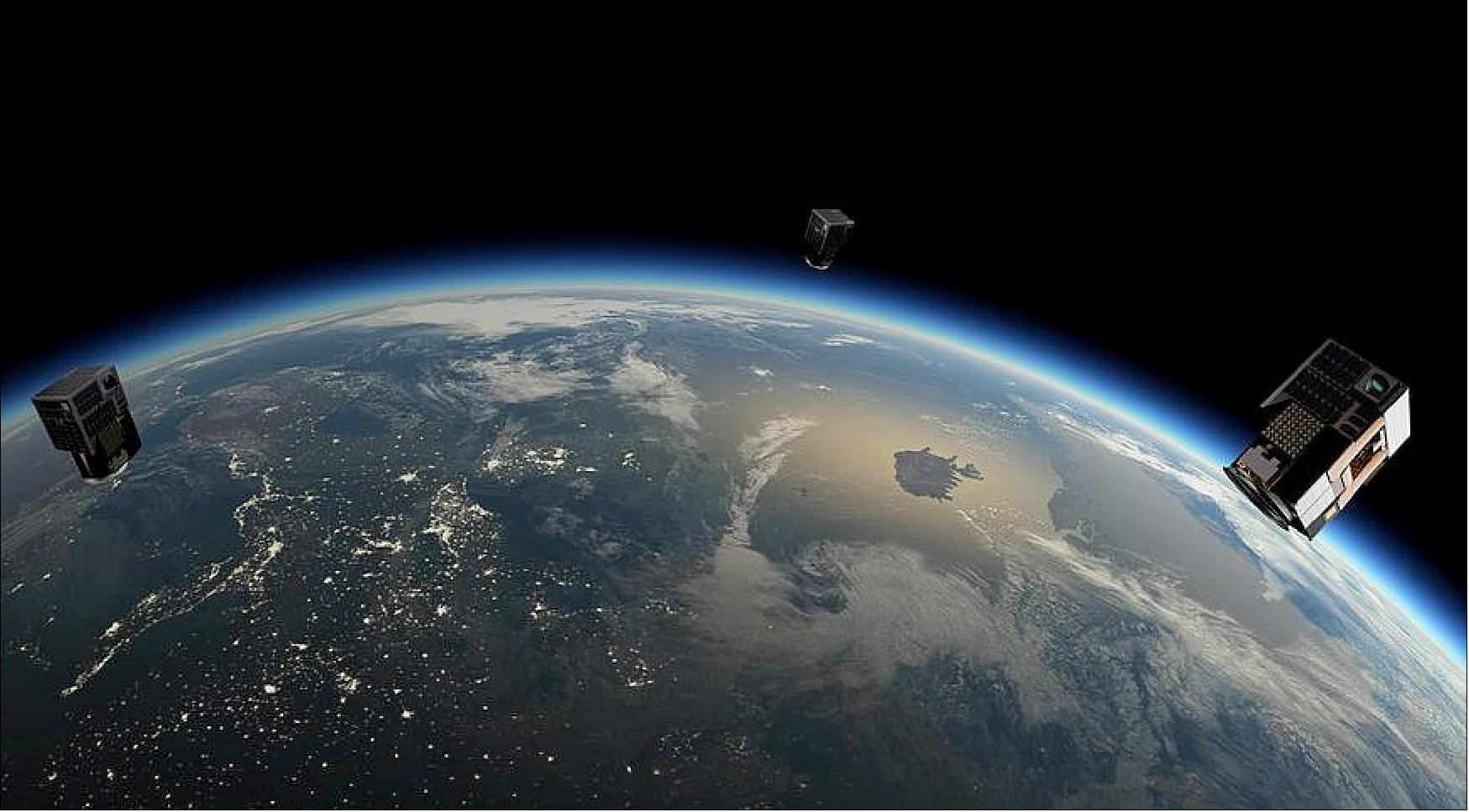
The NewSat series is a sequence of commercial Earth observation satellites, designed, built and operated by the Argentinean company Satellogic. The 38 operating satellites form the Aleph-1 constellation, first launched in 2016. The still and video imagery delivered by these microsatellites is available to customers for applications in the fields of agriculture and food production, monitoring tasks within the oil and gas industry, cartography and urban planning, climate monitoring, resource management, disaster response, and infrastructure monitoring.
Quick facts
Overview
| Mission type | EO |
| Agency | Satellogic |
| Mission status | Operational (nominal) |
| Launch date | 30 May 2016 |
| Measurement domain | Land |
| Measurement category | Cloud type, amount and cloud top temperature, Cloud particle properties and profile, Multi-purpose imagery (land), Landscape topography |
| Measurement detailed | Cloud imagery, Cloud liquid water (column/profile), Land surface imagery, Land cover, Land surface topography, Visibility |
| Instruments | Imager |
| Instrument type | Cloud profile and rain radars, Other, Communications, Data collection |
| CEOS EO Handbook | See NewSat (Aleph-1 Constellation) summary |
Summary
Mission Capabilities
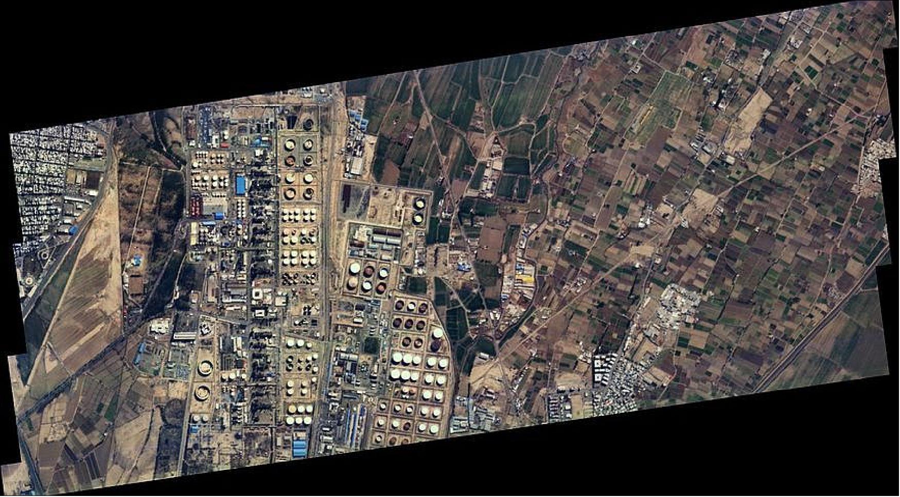
All of the NewSat satellites are identical, carrying an imaging system which operates in the visible and near-infrared spectrum to produce high definition video material and static images of the Earth. The imagery is obtained via a panchromatic imager, which produces grey-scale frames, as well as a multispectral imager. Hyperspectral imagery at very high resolution is also available.
Performance Specifications
The operational 26-satellite constellation achieves a 1.2-hour revisit time, equivalent to 20 intraday scenes from a chosen location. Each satellite (built for a three-year service life) collects up to 1000 scenes per day, with a data volume of around 50 MB per scene.
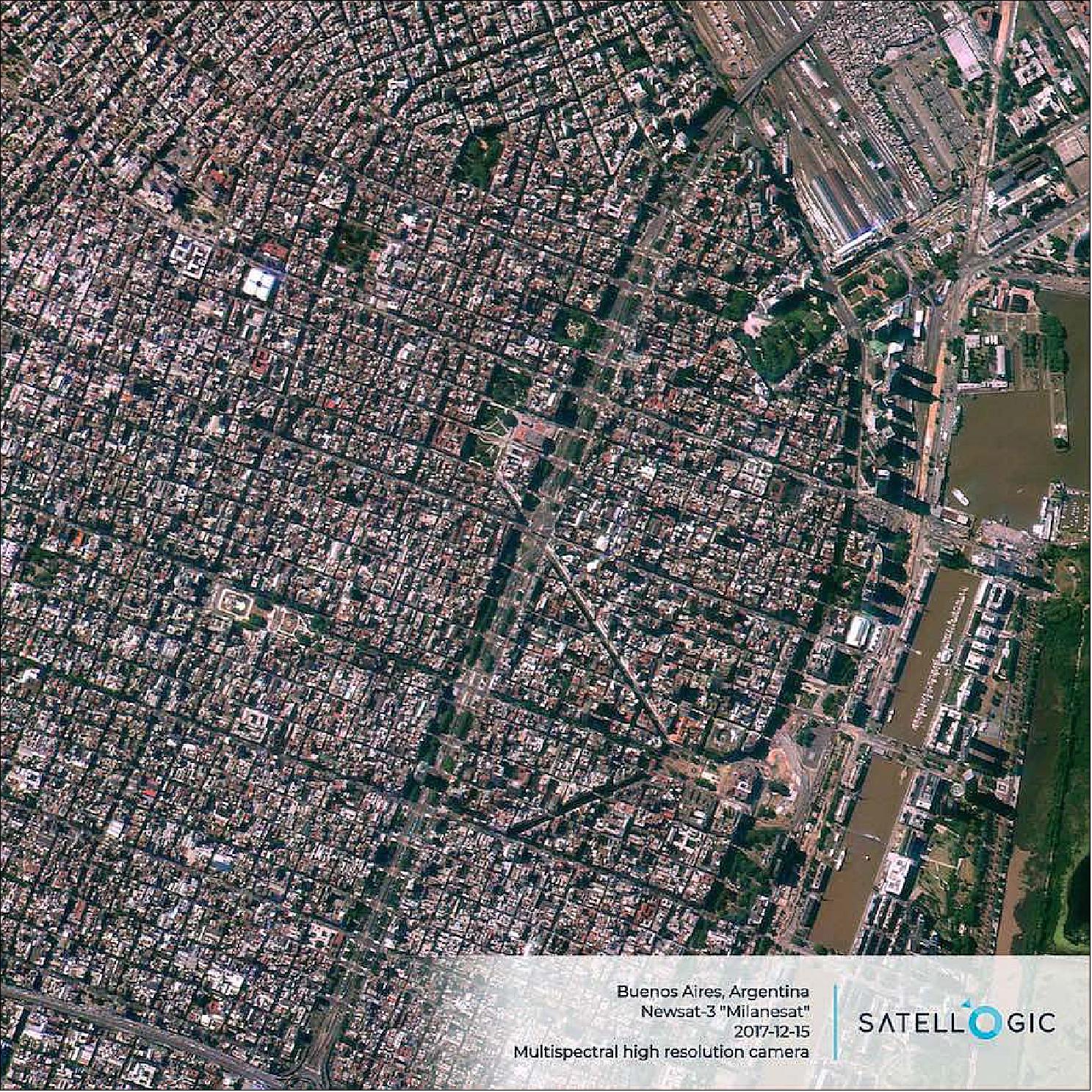
The panchromatic imager delivers black-and-white imagery at a ground resolution of 1 m, being sensitive to light with wavelengths between 400 and 900 nanometers. Monochromatic full motion video recordings of 10 frames per second can be taken for up to 60 seconds. The multispectral imagery delivered by the satellite from a 5 km ground swath also has a 1 m ground resolution, covering five spectral channels: four dedicated to the red-green-blue system and to broad range imaging, plus one near-infrared channel operating in the 750 to 900 nm wavelength interval. The temporal resolution of multispectral imaging is seven times per day, while the hyperspectral imaging has one or two daily visits and covers 29 spectral frequency bands with a 25 m ground resolution.
The satellites are capable of capturing images within a 25° degree cone off-nadir.
They maintain a Sun-synchronous orbit at an altitude of 500 km, with a 97.5° inclination.
Space and Hardware Components
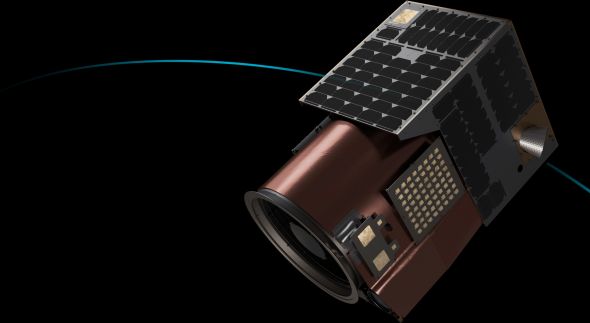
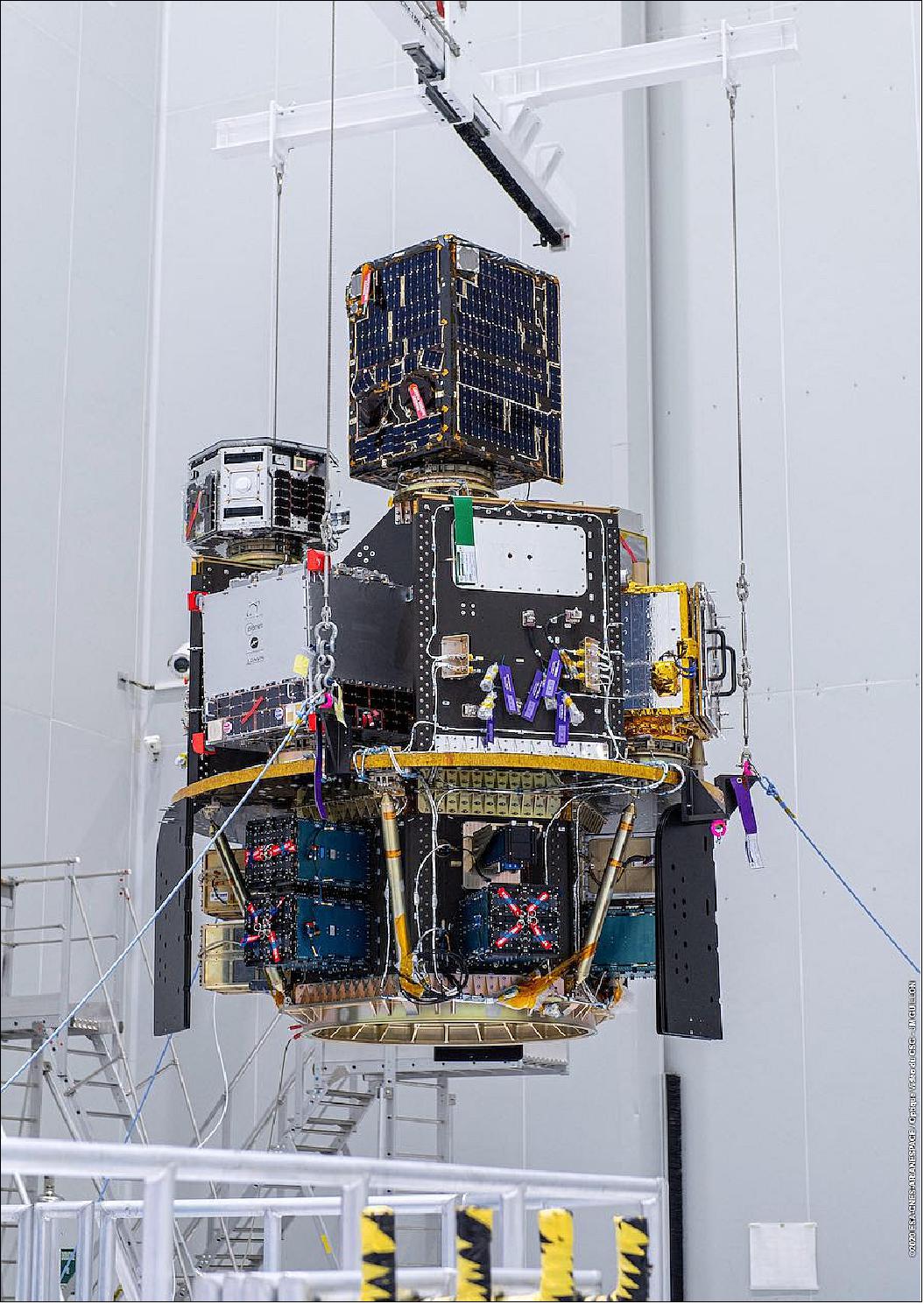
The NewSat microsatellites are 43 x 45 x 75 cm in size, with a mass of about 37 kg. They employ S-band for command uplink and two X-band feeds, one at 8030 MHz using a custom protocol for 100 kbit/s telemetry downlink and a high-speed DVB-S2 (Digital Video Broadcasting-Second Generation) channel operating at 8050-8100 MHz for downlink of image products. They function with a signal-to-noise ratio of 43 decibels.
NewSat (Aleph-1 Constellation)
Overview Spacecraft Launch Mission Status Sensor Complement Ground Segment ReferencesOverview
Satellogic is an Argentine company specialized in Earth-observation satellites, founded in 2010 by Emiliano Kargieman and Gerardo Richarte. The company HQs are based in Buenos Aires Argentina. The overall objective of Satellogic is to provide real-time imaging of the entire planet on a daily basis. Kargieman envisions accomplishing this goal through a constellation of EO satellites in the future. 1)
We want help solve the world’s most pressing problems. How will we provide food for nine billion people? How will we meet our energy needs without draining resources from future generations? How is our world changing? By building an accurate and up-to-date picture of our planet and the many forces that reshape it everyday, we work to answer these questions and more.
Background
As I write this article in the midst of the COVID-19 pandemic, I cannot but reflect on the role that our industry should be playing to help with the management of the crisis and the long road of reconstruction ahead, and that we are not yet in a position to fulfill. 2)
The wide adoption of satellite-based Earth Observation (EO) data can and should play a critical role in the resiliency mindset that dealing with the current crisis requires, but that in turn demands that we learn to build the technology, the infrastructure, and most specifically the business models needed to deliver actionable, affordable and timely information to actors globally.
This technology/infrastructure/business-model stack can be modeled based on the Platform-as-a-Service, Software-as-a-Service, and other -as-a-service models that have transformed the distribution of software and information, and are at the core of the digital transformation for a wide variety of industries. Subscription business models are, as of yet, seldom used and with very limited impact in the EO market — even if they have proven elsewhere that they are well adapted for the distribution of proprietary, high-value added solutions. I’ll take a look at the reasons for this, in order to see if we can derive a series of drivers for the adoption of subscription and metered business models for the EO industry.
We should start by taking a look at the Information Technology industry, where this new generation of subscription services encompasses the sharing of infrastructure, applications and business processes through the internet. The idea of sharing compute resources is at least as old as time sharing, back in the 1970s, but the scale and scope of the current services commercialized in subscription models had to wait for the availability of the security-rich, scalable, standards-based shared computer environments of what we call today cloud computing, in the second half of the 2000s. Those vast, internet connected data-centers allowed for the commoditization of compute infrastructure and the implementation of a metered, utility business model for computation1 that sets the foundation on top of which subscriptions to value-added services can be layered.
For all of the talk of the commoditization of satellite imagery, the EO market, and the wider Global Geo-information market, have not been able to rely on a metered supply that covers all the requirements to sustain such a revolution: necessity, reliability, usability, affordability and scalability.
Necessity — simply put, the fact that users consider this supply a necessity, clear in utilities such as water, electricity or communications; sometimes, as is the case in compute power, gaining this place takes time, but once the users start to count on this supply to conduct business, utilities blend into the background and become a necessary part of day-to-day life.
In the current EO market, mid and low-resolution satellite imagery might be argued to fulfill every other requirement in this list, but have failed to become a necessity for business: they are a nice to have, or good to have layer of information but users don’t depend on this data source to fulfill their day-to-day work. High-resolution, and very high-resolution data sources might become necessary for business, but have faced challenges in some of the other dimensions.
Reliability — the supply must be readily available for the user when and where it is needed. Both guaranteed revisits and remap frequency have proven challenging for the EO industry, for natural reasons, such as cloud-cover; for economic reasons, like the opportunity cost associated with tasking rights and pointing satellites to specific targets; and for regulatory reasons, like shutter-control and satellite operation licenses. Scaling the infrastructure in-orbit to address average service needs and accommodate peak demand seems to be the only viable alternative to address this issue.
Usability — regardless of how technologically complex they are to produce, utility services need to be simple and intuitive to use. Building a supply as easy to access as plugging into an electrical outlet or opening a faucet requires a great deal of standardization, packaging and processing to be able to support the most unsophisticated users. Current EO data products have still a long-way to go, but analysis ready data, and semantic layers based on standardized ontologies promise to bridge this gap.
Affordability — metered models, better adapted to less value-added products, or subscription models more adapted to value-added services and solutions, both require the end product to be affordable to customers. Affordability might require sophisticated pricing schemes, where the final price is tied to the value the service has for the end customer. In most instances in the existing EO market, the pricing is driven by the cost of data acquisition, and it prevents the utilization by customers much in need of it.
Scalability — utilities might be capital intensive, but they are businesses that favor economies of scale: as production capacity increases, the cost of production falls. In Earth Observation, there are still unexplored economies of scale on the supply side: for the moment, in everything but low-resolution data, the competition for scarce data acquisition resources has been the biggest barrier to scalability.
These five characteristics are the keys to drive wide adoption for EO data in mainstream applications, via the implementation of metered and subscription-based utility models to support a wide-range of users globally.
There are satellite-based services, such as GPS and geostationary communication relays, that have blended into the background for every business, government and individual. When I started Satellogic, I dreamt of a future where satellite-based EO would raise to the same fate: where our data would blend into the background and become a fundamental part of daily decision-making for every government, business and individual in the planet, even if in the end they gave no conscious thought to the fact that satellites were involved in those processes.
In the last decade, as an industry we have made some progress, but we are still short on delivering on this promise. I hope that by embracing the utility paradigm and building the infrastructure and business models I described, we can support a wide range of new applications and discover the true potential of our technology.
At Satellogic, we believe in helping to build a world where everyone is prepared for the challenges of tomorrow. We strive to help solve the world’s most pressing problems by building an accurate and up-to-date picture of our planet and the many forces that reshape it every day.
Until today, geospatial analytics has been mostly used as a planning tool on a strategic level, but the challenges we face force us to rush to transform these tools into tactical decision-making tools for everyday action.
In the midst of our current crisis, the components required to collect geospatial data at scale, analyze it and derive insights to feed a resilient loop, need to rise to the occasion to become a key part of the toolset to build and operate the resilient infrastructure of a very dynamic 21st century.
Spacecraft
Founded in 2010, Satellogic S. A. is headquartered in Buenos Aires, Argentina from where company operations are managed. The Aleph satellites are manufactured at a facility in Montevideo, Uruguay, data processing is completed in Tel Aviv, Israel and sales departments are situated in different locations including the United States. 3)
The NewSat satellite series (Spanish: NewSat, sometimes translated into English as NewSat), is a series of Argentinean commercial Earth observation satellites. They form the Aleph-1 constellation, which is designed, built and operated by Satellogic. 4)
Satellogic built also Argentina's first two demonstration nanosatellites. CubeBug-1 was launched on 26 April 2013 on a CZ-2D rocket from JSLC (Jiuquan Satellite Launch Center) of China, and CubeBug-2 was launched on 21 November 2013 on a Dnepr rocket from Yasny, Russia. The next satellite, BugSat-1, was launched as a secondary payload on a Dnepr vehicle from Yasny, Russia, on 19 June 2014.
The NewSat (Aleph-1) satellite series is operated by the Argentinean company Satellogic for the collection of Earth image products to be made available on the commercial market. The Aleph-1 constellation will consist of up to 25 satellites, enabling rapid revisit times and a large daily imaging capacity. 5) 6)
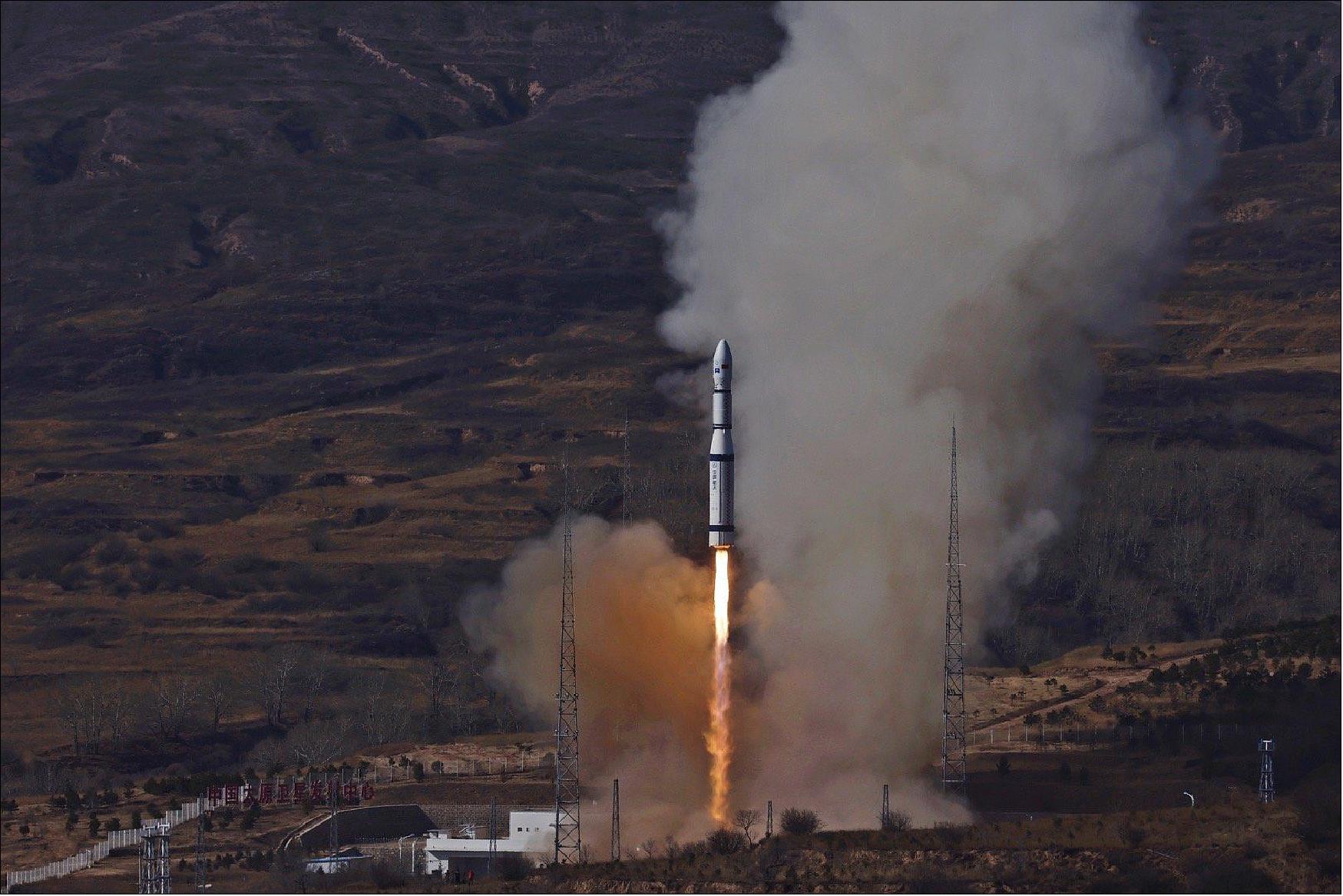
The first two operational Aleph-1 satellites, named Fresco and Batata, launched as secondary payloads on a Long March 4B rocket (CZ-4B) on May 30, 2016 – riding with the Ziyuan 3-02 satellite into a 480 x 498 km Sun-synchronous orbit at an inclination of 97.5º (10:30 LTAN). The Aleph-1 3 microsatellite was launched in June 2017 on a CZ-4B rocket alongside the HXMT (Hard X-ray Modulation Telescope), a Chinese X-ray Space Observatory, and two smaller secondary payloads, headed into a non-synchronous orbit at an inclination of 43º.
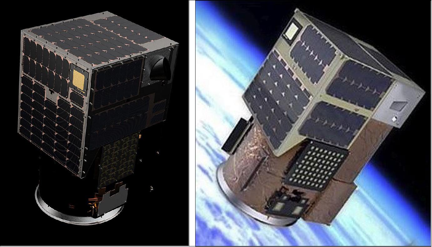
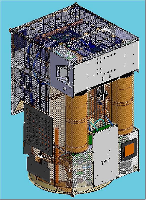
Developed and built by Satellogic S. A. in Argentina, the NewSat microsatellites are 43 x 45 x 75 cm in size with a mass of ~37 kg. The microsatellite bus and its imaging payload were tested as part of the BugSat-1 mission launched in 2014.
According to Satellogic, the first three Aleph satellites were used as a Constellation Prototype, verifying the integrated system from data acquisition in space, data downlink to the ground, processing and distribution to users as well as quick tasking of the satellites to be able to respond to targets of interest.
Communications: TT&C: Uplink is S-band; downlink in X-band at 100 kbit/s, custom protocol. Payload: Downlink in X-band DVB-S2. The subsystem has also a semi duplex UHF Ham frequency link @ 20 kHz BW for experiments and linear transponder UHF/VHF @30 kHz BW.
Launch
As of May 2024, Satellogic has launched over 40 satellites for the NewSat constellation and more are planned for the following years.
All the NewSat satellites have the following orbit specification:
Orbit: Sun-synchronous orbit, altitude = between 475 km and 600 km, inclination = 97.4º-98º. 36) 41) 42) 43)
For a full list of NewSat satellites launched to date, please refer to Table 1, each satellite up to NewSat-44 has the nickname of famous women who have worked in STEM subjects. 37)
NewSat-46, launched on April 7, 2024, has been named TSAT-1A.
TSAT-1A is a small sub-meter resolution earth observation satellite developed by Tata Advanced Systems Limited in collaboration with Satellogic and it is based on Satellogic's Mark V iteration of their NewSat satellites. 38)
Name of mission | Nickname | Launch date | Launch vehicle | Outcome |
NewSat 1 (Aleph-1 1) | Fresco | May 30, 2016 | CZ-4B, China | Success, First commercial |
NewSat 2 (Aleph-1 2) | Batata | May 30, 2016 | CZ-4B | |
NewSat 3 (Aleph-1 3) | Milanesat | June 15, 2017 | CZ-4B | Success |
NewSat 4 (Aleph-1 4) | Ada | February 2, 2018 | CZ.2D | Success |
NewSat 5 (Aleph-1 5) | Maryam | February 2, 2018 | CZ-2D | Success |
NewSat 7 (Aleph-1 7) | Sophie | January 15, 2020 | CZ-2D | Success |
NewSat 8 (Aleph-1 8) | Marie | January 15, 2020 | CZ-2C | Success |
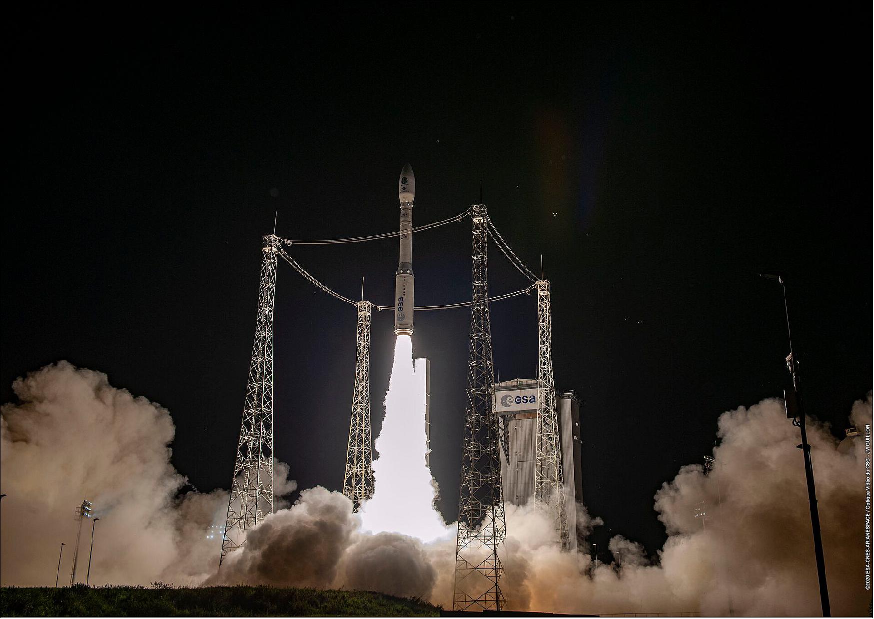
NewSat 6 (Aleph-1 6) | Hypatia | September 3, 2020 | Vega SSMS, rideshare mission | Success |
NewSat 9 (Aleph-1 9) | Alice Ball | November 6, 2020 | CZ-6 (Chang Zheng-6 ) | Success, all 10 microsatellites |
NewSat 10 (Aleph-1 10) | Caroline Herschel | |||
NewSat 11 (Aleph-1 11) | Cora Ratto | |||
NewSat 12 (Aleph-1 12) | Dorothy Voughan | |||
NewSat 13 (Aleph-1 13) | Emmy Noether | |||
NewSat 14 (Aleph-1 14) | Hedy Lamarr | |||
NewSat 15 (Aleph-1 15) | Katherine Johnson | |||
NewSat 16 (Aleph-1 16) | Lise Meitner | |||
NewSat 17 (Aleph-1 17) | Mary Jackson | |||
NewSat 18 (Aleph-1 18) | Vera Rubin | |||
NewSat 19 (Aleph-1 19) | Rosalind Franklin | June 30, 2021 | Transporter-2 mission of | Success, all 4 microsatellites |
NewSat 23 (Aleph-1 23) | Annie Maunder | April 1, 2022 | Transporter-4 mission of | Success, all 5 microsatellites |
NewSat 28 (Aleph-1 28) | Alice Lee | May 25, 2022 | Falcon-9 v1.2 (Block 5) | Success, all four satellites have made contact with Satellogic's ground station network |
NewSat-32 (Aleph-1 32), NewSat-33 (Aleph-1 33), NewSat-34 (Aleph-1 34), NewSat-35 (Aleph-1 35) | Albania-1, Albania-2, Amelia Earhart, Williamia Fleming | January 3, 2023 | Falcon-9 (Block 5) | All four satellites have successfully made contact with Satellogic’s ground network |
| NewSat-36 (Aleph-1 36), NewSat-37 (Aleph-1 37), NewSat-38 (Aleph-1 38), NewSat-39 (Aleph-1 39) | Annie Jump Cannon, Joan Clarke, Maria Gaetana Agnesi, Tikvah Alper | April 14, 2023 | Falcon-9 (Block 5) | All four satellites have successfully made contact with Satellogic’s ground network |
| NewSat-40 (Aleph-1 40) NewSat-41 (Aleph-1 41) NewSat-42 (Aleph-1 42) NewSat-43 (Aleph-1 43) | Carolyn Shoemaker Cecilia Payne-Gaposchkin Maria Wonenburger Rose Dieng-Kuntz | June 12, 2023 | Falcon-9 (Block 5) | All four satellites have successfully made contact with Satellogic’s ground network |
| NewSat-44 (Aleph-1 44) | Maria Mitchell | March 4, 2024 | Falcon-9 (Block 5) | Success |
| NewSat-46 (Aleph-1 46) | TSAT 1A | April 7, 2024 | Falcon-9 (Block 5) | Success |
| NewSat-48 (Aleph-1 48), NewSat-49 (Aleph-1 49), NewSat-50 (Aleph-1 50) | August 16, 2024 | Falcon-9 (Block 5) | Success |
Mission Status
• August 16, 2024: Satellogic launched three new satellites, NewSat-48 (Aleph-1 48), NewSat-49 (Aleph-1 49), NewSat-50 (Aleph-1 50), onboard a Falcon-9 rocket as part of SpaceX’s Transporter-11 Rideshare mission. The launch took place at 18:56 UTC from Vandenberg Space Force Base, California.
• April 7, 2024: NewSat-46 (TSAT-1A) was launched to orbit at 7:16 p.m. ET, on SpaceX’s Falcon 9 as part of the Bandwagon-1 mission, from Launch Complex 39A (LC-39A) at Kennedy Space Center in Florida. 39)
India's Tata Advanced Systems Limited (TASL), built TSAT-1A in collaboration with North Carolina-based Satellogic, following a collaboration agreement between the two companies in late November 2023.
TSAT-1A is based on Satellogic's NewSat Mark V satellite, which includes a four-band, 70 cm multispectral camera with monochromatic full-motion video capabilities, and a 29-band, 18 m hyperspectral camera. According to Satellogic, the NewSat Mark V has a lifespan of three to four years.40)
• March 4, 2024: NewSat-44 (Maria Mitchell), was launched on SpaceX’s Transporter-10 rideshare mission, from Space Launch Complex 4E at Vandenberg Space Force Base (VSFB). Liftoff occurred at 2:05 PM PST (22:05 UTC).
Deployment of the 11 payloads onboard this mission were launched from the second stage to two Sun-synchronous orbits (SSO) at altitudes of approximately 520 kilometers and 600 kilometers began almost an hour after launch and lasted until two hours and 33 minutes after launch, including moving to the second orbit.
There were 48 deployment events from Falcon 9, releasing 51 spacecraft, some of which are orbital transfer vehicles (OTVs) carrying other satellites for later deployment, for a total of 53 payloads. SpaceX announced successful deployment of all payloads. 41)
• June 12, 2023: NewSat-40 (Carolyn Shoemaker), NewSat-41 (Cecilia Payne-Gaposchkin), NewSat-42 (Maria Wonenburger), and NewSat-43 (Rose Dieng-Kuntz), were launched on SpaceX’s Transporter-8 rideshare mission, from Space Launch Complex 4E at Vandenberg Space Force Base (VSFB) in California. Falcon 9 is lofting 72 payloads of varying sizes and purposes into a Sun-synchronous orbit. The launch occurred at 2:35 PDT (21:35 UTC). 42)
• April 14, 2023: Satellogic deployed another four NewSat satellites, designated NewSat-36, -37, -38 and -39, launched aboard the SpaceX Transporter-7 mission from Vandenberg Air Force Base in California at 06:47 UTC.
• January 3, 2023: Satellogic deployed four more NewSat satellites, NewSat-32, -33, -34 and -35, launched aboard the SpaceX Transporter-6 mission from Vandenberg Air Force Base in California at 14:56 UTC.
• May 26, 2022: Satellogic Inc. has successfully launched four additional satellites, bringing their operational fleet to 26. These satellites, part of the updated NewSats Mark IV model, were delivered to a sun-synchronous low-Earth orbit via SpaceX's Transporter-5 mission. With plans to have 34 satellites in orbit by Q1 2023 and achieve up to seven daily revisits over points of interest, Satellogic is doubling down on expanding its constellation to enhance Earth observation data accessibility and affordability. The company has also secured a Multiple Launch Agreement with SpaceX for 2023 and beyond, aiming to launch an additional 68 satellites. 7)
• May 4, 2022: Satellogic has signed a contract with SpaceX to launch 68 more satellites, expanding its constellation as part of its goal to remap the entire Earth's surface every week by 2023. The multiple launch agreement, whose terms were not disclosed, follows a similar deal in 2021 covering four rideshare launches. The announcement coincided with Satellogic's publication of its 2021 financial results, reporting revenue of $4.2 million and a net loss of $117.7 million. 8)
• April 25, 2022: Orbital Insight has partnered with Satellogic to integrate high-resolution satellite imagery and full-motion video from Satellogic's Earth observation satellites into its geospatial intelligence platform. This collaboration aims to provide Orbital Insight's customers with access to improved data quality, revisit rates, and cost-effective analytics. Satellogic's business model, focused on lowering costs per square kilometer, aligns with Orbital Insight's goal of making geospatial intelligence more accessible and affordable for government and commercial clients. 9)
• April 4, 2022: Satellogic Inc. has announced the successful launch of five new spacecraft from Cape Canaveral Space Force Station, marking the deployment of its new Mark V satellite model along with four updated NewSats Mark IV models. Delivered via SpaceX's Transporter-4 mission, these satellites have expanded Satellogic's constellation to a total of 22 satellites in orbit. The Mark V model features enhanced cameras, radios, computers, and other subsystems, offering higher quality products to customers. With plans to launch 12 additional spacecraft this year and the upcoming opening of the High-Throughput Plant, Satellogic aims to democratize Earth Observation data, making satellite imagery accessible and affordable for various applications such as climate change monitoring, infrastructure assessment, and disaster response. Additionally, the company has named its latest satellites after five notable women pioneers in STEM fields, continuing its tradition of celebrating diversity and innovation in space exploration. 10)
• March 10, 2022: Satellogic Inc. has announced the shipment of five satellites for an upcoming launch as part of SpaceX's Transporter-4 mission from Cape Canaveral. This launch will include the debut of Satellogic's new Mark V satellite model, featuring enhanced cameras, radios, and computers, along with four updated NewSats Mark IV. These satellites offer increased onboard storage, propulsion, and navigation upgrades, supporting the company's goal of providing higher quality products and expanding customer opportunities. The Mark V model boasts a proprietary-designed multispectral camera with improved image quality and processing power, while the NewSats Mark IV include Hosted Payloads for customer hardware and last-mile testing of future payloads, including onboard edge computing and RF products, aimed at enhancing Satellogic's satellite capabilities and services. 11)
• February 14, 2022: Joseph Dunford, retired U.S. Marine Corps general and senior managing director of Liberty Strategic Capital, has joined the board of directors of Satellogic, following a $150 million investment by Liberty Strategic Capital in the Earth observation company. Satellogic, which recently went public through a SPAC merger, aims to leverage Dunford's extensive experience, including his tenure as chairman of the Joint Chiefs of Staff, to enhance its offerings of high-resolution satellite imagery and analytics for governments and businesses globally. With a focus on expanding its presence in the U.S. government market, particularly in defense and intelligence, Satellogic seeks to utilize sub-meter satellite data to facilitate informed decision-making across various applications. 12)
• January 26, 2022: Satellogic commenced trading as a public entity on January 26 after finalizing its merger with CF Acquisition Corp. V, a SPAC associated with Cantor Fitzgerald. The merger, providing $262 million in gross proceeds, includes a significant investment of $150 million from Liberty Strategic Capital, led by former Treasury Secretary Steven Mnuchin, supporting the development of Satellogic's satellite constellation for high-resolution imagery. Despite delays in the shareholder vote to secure additional financing, the merger was successfully closed, with Mnuchin appointed as nonexecutive chairman. 13)
• January 19, 2022: Earth imaging company Satellogic will receive a $150 million investment from Liberty Strategic Capital, led by former Treasury Secretary Steven Mnuchin, aiding in the finalization of a delayed merger with a special purpose acquisition corporation (SPAC). With this investment, the total capital commitment to Satellogic, including a previously announced $100 million private investment in public equity (PIPE) round, exceeds $265 million. Mnuchin is set to become the nonexecutive chairman of Satellogic's board of directors upon completion of the merger, which has experienced delays due to factors like shareholder vote postponements and potential redemptions. Despite scaled-back financial projections indicating fewer satellites in orbit by 2025, Satellogic remains optimistic about its ability to provide low-cost, high-resolution imagery to support decision-making for governments and businesses. 14)
• December 28, 2021: Satellogic is set to construct a high-throughput satellite manufacturing facility in the Netherlands, aiming to expedite satellite assembly and accommodate cutting-edge manufacturing equipment. Strategically located in Berkel en Rodenrijs near major cities like The Hague and Rotterdam, the 57,000 square foot facility will support hybrid working models and be led by Gustav Wenhold, boasting Industry 4.0 principles for modern production. This expansion complements the company's existing facility in Uruguay and underscores its commitment to advancing Earth observation technology and accessibility. 15)
• December 16, 2021: Satellogic is poised to commence trading on the Nasdaq following a pending merger with a SPAC, with shareholders of CF Acquisition Corp. V scheduled to vote on the deal on December 20. The completion of this merger is expected to transform Satellogic into a publicly traded entity, allowing it to secure necessary funding for its ambitious satellite constellation project. 16)
• October 6, 2021: Earth observation company Satellogic announced Oct. 6 it will be using Amazon’s ground station service to control its satellites and download data from space. Satellogic has 17 satellites in low Earth orbit and plans to grow its constellation to more than 300 by 2025. 17)
- Satellogic founder Emiliano Kargieman and Amazon Web Services’ director of aerospace and space Clinton Crosier announced the agreement at the 2021 GEOINT Symposium (5-8 October 2021, St. Louis, MO).
- The deal with Satellogic is a significant win for AWS (Amazon Web Services) which competes with cloud rival Microsoft Azure for space industry customers that operate constellations. Satellogic has 17 commercial satellites in low Earth orbit and plans to grow its constellation to more than 300 by 2025.
- Amazon’s ground station is a managed service that allows satellite operations to ingest satellite data and integrate it with apps and other data on the AWS cloud. The service has attracted startups and commercial players that don’t want to invest in their own ground infrastructure. Operators only pay AWS for the capacity they use.
- Imagery and geospatial data providers need large-scale cloud computing. Satellogic is creating a live catalog of the Earth and delivering daily updates. Each spacecraft generates as much as 50 gigabytes of data daily, the company said.
- The amount of imagery downlinked is expected to grow 10-fold, “driving the need to spin up ground station infrastructure and then scale it back down when resources are not needed,” Satellogic said in a statement.
Growth in Government Market
- Satellogic was founded in 2010 in Argentina, and is headquartered in Montevideo, Uruguay, and has offices in several countries. It is now expanding in the United States and Canada.
- In July Satellogic announced it plans to go public via a merger with special purpose acquisition company CF Acquisition Corp. V – a SPAC sponsored by Cantor Fitzgerald. The transaction is expected to be completed early in the fourth quarter of 2021.
- Matt Tirman, president of Satellogic North America, told SpaceNews that the partnership with AWS marks another step in the company’s expansion into the commercial and government markets. Satellogic’s imagery and data analytics services starting this week are being offered on GSA Advantage, an online service used by government agencies to buy commercial products and services.
- “They can buy our imagery right off of a pre-approved rate schedule and pre-approved licensing agreement,” Tirman said.
- Space-based full-motion video is another market segment Satellogic is pursuing. Each of the company’s satellites produces multispectral and hyperspectral imagery, and full motion video.
- “We can get a 60 second clip at about 10 frames per second,” he said. Video from space could be used as an alternative to aerial drones to monitor areas, develop change detection models or track targets on the ground.
- “Where this gets super intriguing is when we start putting up 60 to 200 more satellites over the next 24 to 36 months,” he said. “When you have all of these different passes over an area, being able to do multiple full-motion video collects, you’re going to be able to string together some really interesting time series models.”
• July 6, 2021: Earth imaging company Satellogic announced July 6 it will go public through a merger with a special purpose acquisition company (SPAC), raising the funding it needs to build out a constellation of 300 spacecraft. 18)
- Satellogic said it will merge with CF Acquisition Corp. V, a SPAC sponsored by financial firm Cantor Fitzgerald. The SPAC holds $250 million in cash after going public on the Nasdaq exchange in February, and an additional $100 million will come from a current funding round known as private investment in public equity.
- After debt repayment and expenses, Satellogic expects to have $271 million in cash when the deal closes, which the companies expect to be early in the fourth quarter. The merger will give Satellogic a valuation of $1.1 billion.
- Satellogic, headquartered in Montevideo, Uruguay, but with offices in several countries, currently operates 13 imaging satellites that provide high-resolution and hyperspectral imagery. The company launched four more satellites on SpaceX’s Transporter-2 dedicated rideshare mission June 30 that will be operational in six to eight weeks.
- The funds from the SPAC deal will allow Satellogic to build out its constellation. In an interview, Emiliano Kargieman, chief executive and co-founder of Satellogic, said that he expected the money would “get us to a 300-satellite constellation by 2025.”
- Getting to that full constellation will require investments in satellite production facilities. The company’s satellites have been built in a “pilot plant” it has in Uruguay, but Kargieman said Satellogic is scouting several locations in Europe to build a new facility that will produce satellites at a much higher rate.
- “We expect to hit 60 satellites operating in orbit by the beginning of 2023. That will give us the ability to remap at 70 centimeters resolution of any point on the planet every week,” he said. “And from there, we will continue to grow at roughly 100 satellites per year to get to a 300-satellite constellation by 2025. So, the high-throughput manufacturing facility we’re putting together will allow us to roll out 100 satellites per year.”
- The company sought to raise the funding now upon reaching what he called an “inflection point” after demonstrating the capability of the satellites as well as the business cases and economics of their imagery. “Now it’s the time to grow and scale, and really deliver on our vision.”
- Satellogic had raised modest amounts of funding privately, including a $50 million round in December 2019, but Kargieman said the company decided early this year to explore a SPAC deal. “We saw the opportunity of taking the company public as a way to tap into a source of financing to allow us to grow the constellation,” he said. “The SPAC has given us the opportunity to do that because it’s a vehicle that’s really well adapted to early-stage companies.” He said Satellogic selected a SPAC sponsored by Cantor Fitzgerald because of that company’s background in the financial world, including its sponsorship of several SPACs.
- In an investor webinar published by Satellogic July 6, Howard Lutnick, chairman and CEO of Cantor Fitzgerald, praised the “extraordinary opportunity” that he said Satellogic offered through its vision of low-cost, frequent high-resolution imagery. “This makes for a fundamentally different and better business model,” he said.
- In that webinar, Satellogic argued that it can provide imagery at a cost per square kilometer roughly 100 times cheaper than competitors such as Airbus, BlackSky, Maxar and Planet. The design of the spacecraft allows it to collect 10 times as much imagery, the company said, while its vertically integrated production model produces satellites at one-tenth the cost.
- The company’s financial projections see revenue growing from $7 million in 2021 to $787 million in 2025, starting with defense and intelligence customers followed by commercial customers. It projects reaching positive free cash flow in 2024, as both revenues increase and capital expenditure growth levels off.
- A key test will be its ability to generate revenue growth. The company projects a total addressable market in various fields of $140 billion, with $2.1 billion in business opportunities in the near and longer term. However, its current backlog is only $38 million.
- “This is the chicken-and-egg problem for this industry,” Kargieman said in the interview: customers want low-cost data that requires a large constellation, but the company needs to know what kind of data customers want before building that large constellation. Satellogic has tried to solve that problem with a series of pilot programs with customers in 12 different markets involving both actual satellite data and simulated data.
- “It’s allowed us to validate a total addressable market for us when we reach weekly remaps” in 2023, which he estimates at $40 billion. “That’s given us the confidence to go and make the capex investments that we need to build out this constellation.”
- In the webinar, Kargieman said that, based on the sheer size of the constellation and its imaging capabilities, Satellogic could have, when the full constellation of 300 satellites is in operation, control of more than 85% of the global supply of high-resolution satellite imagery. “This is a winner-takes-most or winner-takes-all market where we’re uniquely positioned to win.”
• June 30, 2021: Satellogic’s 10th mission, launching from Cape Canaveral Space Force Station, increases the company’s industry leading capacity for high-resolution imagery and video. 19)
- Today’s launch further cements Satellogic’s position as the leader in high-resolution data collection from space. As with Satellogic’s 13 commercial satellites already in orbit, these four new spacecraft are equipped with all three of Satellogic’s signature imaging modes, encompassing sub-meter multispectral imaging, 25-meter hyperspectral capabilities, and 1-meter resolution full-motion video (FMV).
- With a total of 17 satellites now in orbit, Satellogic offers up to 4 daily revisits of any point of interest plus expanded collection capacity of more than 5 million km2 per day in high-resolution—offering more in-orbit capability than the next four Earth Observation (EO) companies combined.
- “Our tenth mission is also the first of many with SpaceX, our preferred vendor for rideshare missions,” said Emiliano Kargieman, co-founder and CEO at Satellogic. “I’m thrilled to say that every facet of our partnership has exceeded our expectations. With many more launches on the horizon, we will continue to grow our fleet at an aggressive pace that matches the increased global demand for geospatial insights.”
- By 2025, Satellogic expects that its constellation will include over 300 satellites, providing Satellogic with the capacity to remap the entire Earth daily. By democratizing Earth Observation (EO) imagery, Satellogic is able to serve previously underserved verticals, and partner with US government and Dedicated Satellite Constellations (DSC) customers around the world to provide new insights into the occurrence and progression of economic activities, security risks, and natural events unfolding across the globe.
- “We continue to invest in R&D and test new capabilities. With each launch and every new satellite we put in orbit, we strive to redefine what is possible,” said Gerardo Richarte, co-founder and CTO/CISO at Satellogic. “We relentlessly ask ourselves what more we can do to best support global decision makers working to solve Earth’s most pressing resource utilization and distribution challenges.”
- By collaborating with SpaceX as the company’s preferred partner for rideshare missions, Satellogic has been able to accelerate the time between satellite development and deployment. This allows Satellogic to continue to rapidly expand their in-orbit capacity while also increasing revisit capabilities to monitor the planet on a high-frequency basis, serving customers at the most competitive price.
In keeping with their tradition, Satellogic has named the new satellites after four remarkable women in the history of STEM:
- Rosalind Franklin, the British chemist whose work was crucial to understanding the structure of DNA.
- Grace Hopper, the American computer scientist at United States Navy Rear Admiral who was the first person to devise the theory of machine-independent programming languages.
- Elisa Bachofen, the Argentine engineer and early feminist who was the first female civil engineer in Latin America.
- Sofya Kovalevskaya, the Russian mathematician who was the first woman to earn a Ph.D. in mathematics in Europe, and the first female professor of mathematics in the world.
Founded in 2010, Satellogic is a global company with more than 240 employees and offices in Charlotte, Miami, Barcelona, Buenos Aires, Córdoba, and Montevideo, among others.

• March 14, 2021: Satellogic has announced new partnerships with four, major, US-based space organizations: The United States Geospatial Intelligence Foundation (USGIF), Intelligence and National Security Alliance (INSA), SmallSat Alliance and Open Geospatial Consortium (OGC). 21)
- Through its partnership with USGIF and INSA, Satellogic will help promote the application of geospatial intelligence (GEOINT) toward national security challenges, as well as advance intelligence and national security priorities. These organizational goals align with Satellogic’s long-term mission of providing the public sector with geospatial insights that enable decision makers to improve or protect their environments, including border, resource and infrastructure monitoring.
- The SmallSat Alliance similarly aligns with Satellogic’s strategic goals through the Alliance’s trusted relationship with Congress and broader government officials. By joining the SmallSat Alliance, Satellogic will be able to help promote the usage of smallsat capabilities to complement government programs and roadmaps.
- Through their member-driven consensus process, OGC serves as the leading authority on geospatial standards, ensuring that location information is findable, accessible, integratable and reusable. Together with OGC, Satellogic plans to lead discussions that ensure interoperability of geospatial data. Particularly given Satellogic’s global employee and customer-base, compatibility of geospatial data across country and use case is a leading priority for the company.
- This series of partnerships comes on the heels of Tirman and VanMatre’s recent hires, which further expanded Satellogic’s US presence. Driven by Satellogic’s industry-leading in-orbit capacity and high-resolution imagery, Satellogic has a growing base of US government, international governments and commercial partners.
- “The US government is leading the way when it comes to partnerships with commercial space companies, and we are thrilled to see them diversifying their portfolio to partner with companies like Satellogic to leverage the potential of high-frequency, high-resolution data,” said Matthew Tirman, Head of Satellogic North America. “US officials know that they can take full advantage of the power of industry to help fuel and support their missions, and organizations like USGIF, INSA and SmallSat are instrumental in ensuring the long-term success of these relationships. As the commercial provider with more capacity in orbit than any other, it makes sense for Satellogic to play a leading role through these partnerships.”
- “As commercial space capabilities become more accessible globally, and public-private partnerships become increasingly important to both commercial and federal space entities, the relevance of interoperability through standards and policy cannot be understated,” said Thomas VanMatre, Vice President of Global Business Development at Satellogic. “That’s why Satellogic is proud to join the Open Geospatial Consortium and help guide discussions around the future use and integration of our impactful data.”
• March 11, 2021: Earth observation company Satellogic is expanding its presence in the United States to compete in the government market. It is standing up a U.S. subsidiary specifically to work with national security agencies, Matthew Tirman, head of Satellogic North America, told SpaceNews. 22)
- Satellogic, founded in 2010 and headquartered in Buenos Aires, operates in the United States and other countries around the world. The company has a growing commercial business “but let’s be honest, the biggest market right now is defense and intelligence,” said Tirman, who recently joined Satellogic and previously led the government business at Descartes Labs, a geospatial data analytics firm.
- Satellogic is positioning to compete in the high-resolution satellite imagery market dominated by Maxar, Airbus, Planet and BlackSky. It also provides hyperspectral imagery and full-motion video from space.
- It has 13 satellites in operation that provide 64-centimeter resolution imagery and will launch four more this summer on SpaceX’s Transporter-2 rideshare. Tirman said Satellogic has signed a long-term launch agreement with SpaceX.
- Satellogic manufactures its own satellites and has a goal to build a constellation of 300 spacecraft by 2025, said Tirman, “so we can remap the world every week.” To get there, however, the company will need to raise more money from investors and increase its sales.
- The hyperspectral capability is in final stages of development and will be launched later this year, he said. Hyperspectral data is in high demand in the agriculture sector but is used increasingly by defense and intelligence agencies to analyze trends such as macroeconomic changes over certain parts of the world.
- Satellogic also provides 60-second full motion video of any area of the world. Some customers, for example, want to track debris on the ocean, said Tirman.
- The largest government buyer of satellite imagery is the National Reconnaissance Office. Tirman said Satellogic wants to start conversations with the NRO and with NASA, which uses Earth observation data to track climate change.
- With 13 operational satellites, “we’re trying to figure out how to monetize and operationalize all of this data,” said Tirman. Satellogic has its own data scientists but also plans to partner with analytics companies like Orbital insights and Descartes Labs.
- Later this year Satellogic will start offering a platform for subscribers who want to task satellites themselves to shoot imagery. Another service will be hosted payloads, said Tirman. Companies will be able to place sensors like IoT or AIS on Satellogic’s buses.
- Tirman said Satellogic has spent 10 years doing research and development, and creating a small satellite from the ground up, “and now it’s time to bring the products to market.”
- Satellogic announced March 11 it joined the U.S. Geospatial Intelligence Foundation and the Intelligence and National Security Alliance, two industry groups that promote the application of geospatial intelligence to national security challenges. It also joined the SmallSat Alliance which works with Congress and government agencies, and the Open Geospatial Consortium that sets geospatial standards to ensure interoperability of geospatial data.
• January 20, 2021: Earth observation company Satellogic announced Jan. 19 it signed a contract with SpaceX covering several rideshare launches of its satellites through next year. 23)
- The multiple launch services agreement makes SpaceX Satellogic’s preferred provider for launching its constellation of microsatellites, after previously relying on Chinese, European and Russian vehicles, including a launch of 10 satellites as the primary payload on a Long March 6 Nov. 5.
- In an interview, Emiliano Kargieman, chief executive of Satellogic, said the low prices and frequent launch opportunities that SpaceX offered led his company to sign up. “The new rideshare program that SpaceX has put together has reduced the price on the order of four or five times on a per-kilogram basis,” he said. “That really made the rideshare program compete very well in the market and it caused us to start having conversations with SpaceX.”
- Satellogic plans to conduct its next four launches with SpaceX, starting in June. Additional launches will take place in December and in March and June of 2022. All will be rideshare missions going to sun-synchronous orbits, with at least four satellites on the June launch. The company, which has 13 operational satellites currently, projects having a constellation of about 60 satellites by the end of 2022 or early 2023.
- The company also has the option of flying satellites as rideshare payloads on Starlink missions. Those would go to mid-inclination orbits, which Kargieman said would complement the bulk of the constellation in sun-synchronous orbits. “They give us more diversity in times for revisits for points of interest,” he said, noting the company has one satellite in such an orbit. “We are looking into deploying more mid-inclination satellites over the next 12–18 months, but we have not yet decided exactly when those launches are going to be.”
- Another benefit of the agreement, he said, is the flexibility it offers in determining how many satellites to fly, as well as options for flying satellites on Starlink missions. “It gives us the possibility of making those decisions closer to the launch date.”
- While SpaceX is Satellogic’s preferred launch provider, Kargieman did not rule out occasionally using other providers. “Because we might need some particular orbit, we might still decide to launch a dedicated rocket every once in a while to make sure we have the satellites where we want them,” he said.
- Satellogic is seeing strong demand for the high-resolution imagery its satellites produce, he said, with that demand accelerating in the last year from government customers in particular. “On the government side it’s very clear that there is significant unsatisfied demand,” he said. “The pandemic has accelerated the demand for Earth observation data and geospatial analytics.”
- That demand was a key factor in the decision to select SpaceX, with its launch services allowing Satellogic to accelerate deployment of its constellation. “That’s a good point to invest more,” Kargieman said. “We’re feeling strongly that this is a time for us to double down, scale and continue to bring this data to market at an affordable cost.”
• November 6, 2020: With the successful launch of 10 satellites (as primary payload), Earth observation company Satellogic says it can now move ahead of its rivals in providing high-resolution imagery. 24)
• September 4, 2020: Satellogic has launched their new spacecraft from the Guiana Space Center in Kourou via a launch procured by Spaceflight, Inc. — the satellite, NewSat-6 of the Aleph-1 series, a NewSat Mark IV, was delivered to a SSO (Sun-Synchronous Orbit) of 515 km on a Vega rideshare mission called SSMS (Small Spacecraft Mission Service) from Arianespace at 1:51 UTC on September 3, 2020. The flight, also known as VV16, involved 53 satellites for 21 customers from 13 countries around the world. 26) 27) 28)
- The spacecraft is named “Hypatia” after the philosopher, astronomer, and mathematician (350-415 A.D.) who lived in Alexandria and was a symbol of learning and science. She was renowned in her own lifetime as a great teacher and a wise counselor and as an icon for women’s rights.
- In line with Satellogic’s NewSats already in orbit, Hypatia is equipped with sub-meter multispectral and 30 meter hyperspectral cameras. This NewSat Mark IV is also equipped with new technologies in service of Satellogic’s research and development of Earth Observation (EO) capabilities. Upon successful commissioning, these new capabilities will be available to existing Satellogic customers.
- The launch demonstrates Satellogic’s ability to adapt its satellites to different rockets and deployment systems. This mission will also allow Satellogic to test sub-meter imaging technology.
- Satellogic’s current constellation remaps the planet at high resolution, which combined with Satellogic’s low-cost offering, has opened up applications for its customers across industries. Through the refinement of sub-meter imaging, the company plans to further drive down the cost of high-frequency geospatial analytics.
- This news follows Satellogic’s launch in January 2020 of two spacecraft with China Great Wall Industry Corporation. Satellogic now has 11 satellites on-orbit, bringing the company closer to its established vision of a constellation that is capable of delivering weekly, high-resolution remaps of the entire planet at a price that will set a new standard for access and affordability in this market.
- “We design and build our own satellites, which gives our R&D teams the chance to validate new technologies in every launch. Each new generation of our satellites includes new products and further delivers on the promise of new space,” said Satellogic Founder and CTO, Gerardo Richarte. “This launch is an exciting indicator of all that is to come as we continue to bring new solutions into production and deliver them into space and to our customers.”
- “Ambitious research and development efforts are crucial to both the development of the space industry and to humanity’s advancement overall,” said Stephane Israël, CEO of Arianespace. “We’re proud to work with Spaceflight to launch Satellogic’s newest satellite, which will enable Satellogic to test technologies that have the potential to dramatically reduce the cost of high-resolution, high-frequency geospatial insights.”
• December 19, 2019: Commercial Earth imaging company Satellogic announced Dec. 19 that it has raised $50 million to help it scale up its satellite constellation. 29)
- The company, headquartered in Buenos Aires, said it raised the new funding round from a mix of new and existing investors. Two existing investors, Chinese company Tencent and Brazilian fund Pitanga, contributed about 40% of the funding. The rest came from new investors, including IDB Lab, the “innovation laboratory” of the IDB (Inter-American Development Bank).
- “At IDB Lab, our mission is to leverage innovation towards inclusion in Latin America and the Caribbean,” Tomás Lopes Teixeira, senior investment officer at IDB Lab, in a statement. “We’re excited to support Satellogic’s mission of democratizing access to geospatial analytics solutions.”
- In an interview, Emiliano Kargieman, chief executive of Satellogic, said the funding will enable the company to speed up the deployment of its satellite constellation, with the goal of providing imagery of the entire Earth at a resolution of one meter and updated every week.
- “This funding, for us, is a way for us to continue to build on our momentum,” he said. “We’re going to use the proceeds to fund more technology development and product development, but also to scale up our constellation of satellites a little quicker.”
- The company has eight satellites in orbit and plans to launch 16 satellites in 2020, with the first two scheduled to launch from China in mid-January. “We’re looking at opportunities to see if we can speed up our rollout,” Kargieman said.
- To achieve that goal of “remapping” the globe weekly at one-meter resolution will require a constellation of about 90 satellites. He said the company has plans to do that over the course of 24 months, but will need to increase its manufacturing capacity and launch rate in order to do so.
- The technology development and the funding enables will go towards improving the capability of the satellites, with plans to sharpen the imaging resolution to 70 centimeters. Other improvements will include increasing downlink capacity and improved on-orbit processing of images. “We’re going to continue to push the limits of what you can do with a small optical imaging satellite,” he said.
- The funding will also enable more product development work. “We’re working on packaging the data that our satellites deliver in ways that can better serve our customers,” he said. “It will make it easier for companies to use satellite data for decision making.”
- The funding announcement comes three months after Satellogic announced a $38 million agreement with ABDAS, a Chinese data science company, for a product Satellogic calls a “dedicated satellite constellation.” ABDAS will have control over what sites to observe within China’s Henan Province when the satellites are passing overhead.
- The company hasn’t announced any new dedicated satellite constellation customers since then, but Kargieman said there’s considerable interest in the concept. “It’s had a lot of traction with governments, particularly governments that don’t have their own existing Earth observation capacity,” he said. “This ‘satellite as a service’ model that we’re offering has excellent capabilities at a fraction of the cost of any alternatives.”
- This funding round, he said, should be enough to see the company through to profitability. “With the backlog and pipeline that we currently have, and this funding, we can start scaling up our constellation of satellites and work on technology development and still be in a position to keep the company profitable and growing.”
• September 13, 2019: Earth imaging startup Satellogic has signed an agreement with a Chinese company that will give it access to its fleet of satellites for imaging a Chinese province. 30)
- The agreement with ABDAS, a Chinese data science company, gives that company exclusive access to Satellogic’s constellation of imaging satellites for imaging sites within China’s Henan Province. ABDAS will have control over what sites to observe within the province when the satellites are passing overhead. The agreement is valued at $38 million, Satellogic said in a Sept. 9 statement.
- The deal is the first for a concept Satellogic calls a “dedicated satellite constellation.” It gives customers exclusive control over a number of satellites over a specific geographical region. Customers have control over tasking of the satellites as if the satellites were their own.
- “It’s basically an alternative to having to go buy a satellite, or a number of satellites,” said Emiliano Kargieman, chief executive of Buenos Aires-based Satellogic, during an interview Sept. 12 at Euroconsult’s World Satellite Business Week in Paris. “It has all the benefits of a service model. You get the ownership without the cost.”
- He said the company has seen “significant traction” for the dedicated satellite constellation concept for customers at both the regional and national level, particularly for countries that are just starting to develop Earth observation capabilities, such as in Latin America and Africa. “We expect this to be the first of many” such deals, he said.
- Satellogic currently has eight satellites in orbit, providing multispectral imagery at a resolution of one meter and hyperspectral imagery at a resolution of 30 meters. Sixteen more satellites are scheduled for the next several months on Long March and Vega rockets. That includes 13 on a dedicated Long March 6 rocket in July 2020.
- With at least 20 operational satellites in orbit, Kargieman said the company will be able to provide multiple revisits per day and “remapping essentially the entire planet” monthly. The company will then move on to a 90-satellite constellation that could be ready 24 months later, for weekly remapping globally. “We believe that is the sweet spot in terms of frequency and resolution to start really improving the more mainstream applications of Earth observation,” he said.
- He said the company is fully funded through the next set of satellites. Moving on to the 90-satellite constellation may require another equity funding round, he said, along with cash flow from operations and debt.
- A unique aspect of Satellogic’s satellites is the inclusion of the hyperspectral instrument, but Kargieman said there’s been little commercial interest in that so far. “Commercially, I think hyperspectral is still a very experimental capability,” he said, especially at the lower resolution that Satellogic’s satellites can provide.
- The company is making that hyperspectral data to researchers to experiment with it for potential applications, while using it in its own data analysis pipelines in combination with multispectral images and other data. Kargieman said the company will carry hyperspectral instruments on its upcoming set of 16 satellites, “because we believe there is value in this data set, and this value will grow as we have more frequency of data.”
• January 30, 2019: The Satellogic company announced a new contract Jan. 15 with China Great Wall Industry Corporation to launch 90 more microsatellites aboard Chinese Long March rockets, the largest single deal for Chinese launch industry on the international commercial market in more than 20 years. 31)
- “We’re putting our next 90 satellites into orbit with them over the next 24 months,” said Emiliano Kargieman, founder and CEO of Satellogic. “This is really a milestone for us, for Satellogic.”
- Satellogic and China Great Wall — the state-owned company charged with marketing Long March launch services internationally — declined to release the monetary value of the launch contract.
- Based in Argentina and backed by Chinese financing, Satellogic is building a fleet of satellites to cover the globe with visible, hyperspectral and infrared imagery. The company is one of several startups active in the commercial Earth-imaging market, along with Planet, BlackSky, ICEYE, and others.
- Each company offers a different service, but all use — or plan to use — nanosatellites and microsatellites to image the Earth, cutting costs compared to traditional satellite operators and providing the capability to scan the entire planet more rapidly.
- The 90-satellite fleet in development at Satellogic “allows us to build out the constellation that we need to map the planet at 1-meter resolution every week, and we think this combination of high-resolution data will really put us in a position to start paying off on the promise of Earth observation to improve decision-making for a wide range of industries, and democratizing access to this kind of information, which we believe is very valuable,” Kargieman said in an interview with Spaceflight Now.
- Five or six launches using a combination of Long March 6 and Long March 2D rockets will deliver the 90 satellites to orbit by the end of 2020, according to Satellogic, which is headquartered in Buenos Aires and has its satellite manufacturing facility in nearby Montevideo, Uruguay.
- The 90-satellite constellation planned by Satellogic follows the launch of five NewSat Earth-observing smallsats on Long March 4B and Long March 2D rockets since 2016. Three more NewSat-type satellites are slated to fly as secondary payloads on a Chinese launch later this year, before Satellogic begins flying spacecraft on dedicated Long March missions, Kargieman said.
- “The next three satellites that we will launch will actually be on a rideshare that we’ve had on contract for a while, and it’s been delayed a few times, as is usually the case with rideshares,” Kargieman said. “But this announcement that we’re making is for a series of dedicated launches, and part of the reason we believe this is a big milestone for us, is it allows us to get control of our own schedule, for the rollout of the satellites, and not having to depend on the primaries, due to the complications of piggybacks.”
- The Long March 6 rocket (CZ-6) can launch 13 of Satellogic’s satellites at a time, and the bigger Long March 2D (CZ-2D) can carry up to 36 spacecraft per mission, according to Kargieman. The first dedicated launch using the Long March 6 rocket is planned later this year.
- Satellogic builds and operates its own satellites, using no components that are sensitive to U.S. export restrictions under International Traffic in Arms Regulations, laws which prevent the use of some U.S.-made spacecraft components on satellites launching aboard Chinese rockets. Many satellites not manufactured in the United States often rely on subsystem components made by U.S. companies.
- “We designed the satellites outside of the U.S., we’re not using any of those components,” Kargieman said. “We have full control over the compliance. One of the design goals was to make it resilient to all of the different regulations, and part of that is avoiding the overhead and the complications of ITAR (International Traffic in Arms Regulation) and other export restrictions.”
- “We’ve talked to all of the launch providers,” he said. “These 90 satellites are not the last 90 satellites that we will ever launch, and we expect to launch from a variety of different launchers in the future. The truth is it was a very natural decision for us because of the eight satellites that we’ve launched so far, seven were launched with Chinese rockets, and we’ve established a really good partnership with China over the years. We know the team well. Their team knows our team very well, so communication is very fluid.”
- In the end, China Great Wall’s launch offering was the “right agreement” for Satellogic, Kargieman said.
- Kargieman said the next 90 satellites being built by Satellogic will be “incremental evolutions” of the NewSat design, also known as the Aleph 1 series. The spacecraft will launch into polar, sun-synchronous orbits around 500 kilometers in altitude.
- “They’re around 45 kg at launch, including propellant,” Kargieman said. “They’re sort of the size of a small fridge, and 1 x 0. 5 x 0.5 m. They’re pretty small and lightweight.”
- Satellogic currently has around 15 satellites in various stages of production at the company’s factory in Uruguay, according to Kargieman.
- ”In oil and gas, we have been (supporting) pipeline monitoring, oilfield monitoring for environmental and security reasons,” he said. “In forestry, we’re particularly focusing on operations management for forestry companies and for pulp and paper companies. In agriculture, we have been working on some applications that require higher-resolution. For governments, we’ve been working a lot on rural cartography, one of the areas where we expect a lot of value to come from 1-meter resolution data.
- “Irrigation management is another area where we have deployed applications and solutions. Supply chain management for companies with large agricultural footprints in their supply chain. These are some of the applications we have currently in the works,” he said.
• June 27, 2018: The Argentine satellite company Satellogic has launched a subscription-based service that will allow customers, including government agencies or non-governmental organizations, to purchase satellite images over a specified area of interest. 32)
- Satellogic satellites collect both high-resolution images, with 1-meter resolution, and hyperspectral images, which can show more detailed information about objects, such as their chemical composition. The company’s new venture, known as the Dedicated Earth Observation Satellite Program, offers access to customized images and data.
- Whether monitoring at the cars-on-roads level or tracking the environmental effects of a forest fire, among other activities, subscribers will be able to determine what photos should be taken. Each entity subscribing to a Satellogic constellation would have access to 10 satellites over a designated area at a cost of about $2 million dollars per satellite per year, or $20 million in total per year, according to Kurt Billick, vice president of strategy and business development at Satellogic.
- Potential customers might include corporations, NGOs (Non-Government Organizations) and national or regional governments that do not have the capability to launch their own satellites, said the company’s founder, Emiliano Kargieman.

• June 2017: Satellogic, a company developing a constellation of satellites designed to provide high-resolution and hyperspectral imagery, has raised $27 million to continue that effort in a round led by a Chinese company. 33)
- Satellogic, a company with operations in several countries, announced its Series B funding round June 23, led by Tencent, a Chinese investment holding company that is one of the largest in the world. Also participating in the round were a Brazilian venture capital fund, Pitanga, and San Francisco-based CrunchFund, among other investors.
- In a June 26 interview, Emiliano Kargieman, founder and chief executive of Satellogic, said that the Series B fund will be used to scale up the company. “We’re mainly going to be using this to scale the satellites in our constellation and build up our commercial team as we start to go to market,” he said.
- Satellogic has been building small satellites that carry both a high-resolution camera capable of taking images with a resolution of one meter as well as a hyperspectral instrument with a resolution of 30 meters. The hyperspectral instrument can identify the chemical composition of what it observes, with applications for agriculture, environmental and related uses.
- The company launched its third high-resolution satellite June 15 as a secondary payload on a Long March 4B rocket from the JSLC (Jiuquan Satellite Launch Center) in China. Two more are scheduled for launch in August, Kargieman said, followed by 12 to 18 in 2018. “We’re growing this to a constellation of over 60 satellites by 2019,” he said, with a long-term goal of 300 satellites by early next decade.
- Satellogic’s use of Chinese launch vehicles does create some complications for export control, given U.S. restrictions on the exports of satellites and related components to China. “It requires that we have a very tight control over our supply chain,” he said, to ensure compliance with those regulations.
- Despite the funding from Tencent and use of the Long March, Kargieman said that the company is looking into the use of other vehicles to launch its satellites as well. “We’ve talked with a variety of launch providers,” said, adding that working with China has gone well so far. “We’ll definitely continue to work with them, but in the future we don’t have exclusivity with any particular launcher.”
- The company currently has 90 employees distributed across offices in North and South America, Europe and the Middle East. That includes satellite research and development work in Argentina and software development in Tel Aviv. Kargieman said he estimated the company’s headcount would grow by 50 to 70 percent in the next year as it deploys more satellites and starts delivering data to customers.
- The company, as it develops and launches these satellites, is also working to demonstrate the benefits of hyperspectral imagery to potential customers. “When you get to hyperspectral imaging, it’s a very new payload,” he said. “That means there’s a little less understanding, at least commercially, of what it’s useful for.”
- Satellogic is working with prospective customers in several industries to demonstrate how hyperspectral imagery can be used, including how it can be combined with high-resolution images and other data sets. Kargieman emphasized providing customers not with raw images but with data products derived from that imagery.
- “Basically, we can attack the mass of information with machine learning techniques, deep learning, basically data science, to figure out how to extract the most value for our customers in each particular industry,” he said.
- Besides access to hyperspectral imagery, Kargieman argued that the company’s cost efficiency, which he attributed to unspecified technological advantages it has, will give it a competitive edge in a crowded Earth observation market and also grow demand for the information it can provide.
- “There seems to be a growing number of constellations of satellites, a growing number of companies building imaging satellites. That’s come to be too much for this small Earth observation market,” he said. “The mistake is looking at the existing Earth observation market and thinking that’s the market we’re going to be playing in.”
- Instead, he argued, lowering the cost of acquiring data “by several orders of magnitude” from conventional satellites, coupled with rapid revisit times and data analysis tools to extract information from that imagery, is what will set the company apart. “We’ll essentially open up completely new markets for Earth observation data,” he said. “We’ll make this data part of daily decision-making for every industry on the planet.”
• May 23, 2017: Never have so many private eyes looked down at Earth. In the past decade, about a dozen companies have formed to launch Earth-observing satellites. Few have sought to compete with sophisticated government-built instruments, but that is changing. 34)
- Private firms have begun to develop satellite radar systems and other advanced technologies in a bid to court scientists and other users, even as the US government is threatening to pare back its stable of satellites. Later this year, for example, the Finnish firm ICEYE plans to launch a prototype radar instrument — the first step, the company says, towards a constellation of 20 such probes. Until recently, commercial firms had shied away from pursuing radar satellites because they require heavy instruments and consume a lot of power.
- For some scientists, the growing variety of commercial data is enabling previously impossible research projects. But others fear that increasing reliance on private satellite observations could short-change science over time, by making data more costly or creating other barriers to access. “If you go the commercial way, you’re going to shrink the user base and you’re going to shrink the amount of knowledge you gain from it,” says Matthew Hansen, a geographer at the University of Maryland in College Park who uses some private data.
- Remote-sensing companies typically sell their data to the government and to businesses such as private weather forecasters and agricultural firms. They have tended to focus on collecting data in just a few wavelength bands, to provide sharper and more frequent images than government spacecraft can. But various trends — the falling costs of components, the development of small satellites such as CubeSats and improved engineering and manufacturing processes — have allowed firms to pursue more-complex technologies.

- Several firms are looking to develop satellites equipped with radar, which can gather data at night and through cloud cover — situations in which instruments relying on visible light falter. ICEYE’s planned constellation of probes should be able to image a given location many times a day, whereas existing radar-equipped satellites, such as the European Space Agency’s Sentinel-1, return to a given spot only every few days. Other companies with radar projects in development include XpressSAR of Arlington, Virginia, and Urthecast of Vancouver, Canada.
- Some firms are beginning to explore hyperspectral imaging, which spans a wide range of wavelengths, allowing the detection of specific chemicals. In 2016, Satellogic of Buenos Aires launched two 35 kg satellites equipped with custom-designed cameras and light filters. Last month, the company became the first commercial supplier of hyperspectral data. Satellogic’s goal is to fly about 300 satellites, together capable of imaging any location on Earth.
- And it has already begun to appeal to scientists. The company announced in January that it would give researchers free access to its 30-meter-resolution hyperspectral data. These span optical and near-infrared wavelengths and can help track water pollution and oil spills, and monitor the health of forests and crops. “We are receiving contacts from scientists all over the world,” says Satellogic chief executive Emiliano Kargieman.
- But most commercial data must be purchased, and some scientists say the cost can limit their usefulness. Unless companies commit to making data archives available to all who need such information, they will freeze out many cash-strapped junior researchers and people in developing countries, Hansen says. And commercial data simply aren’t good enough for many types of study, despite the technical advances. No commercial satellite matches the consistency and stability of the data collected by the US government’s Landsat probes, which have monitored Earth since 1972.
- Government-funded missions also remain unparalleled in enabling scientists to push frontiers in basic research that may not have immediate applications, says Lorraine Remer, an atmospheric scientist at the University of Maryland in Baltimore. Remer is deputy project scientist for NASA’s planned PACE (Plankton, Aerosol,Cloud, ocean Ecosystem) satellite, and says that she does not know of any instrument aboard a commercial satellite that could produce hyperspectral data to rival those possible with the NASA mission. PACE’s ocean-color imager will enable researchers to identify specific types of aerosol particle in the air, and plankton types in the ocean.
- And governments typically provide the raw data that are used to create images, not just the images themselves, adds Andreas Kääb, a geoscientist at the University of Oslo, Norway, who uses satellite data to study glacier movement. With commercial providers, “once you ask for raw data, you quickly run into problems”, he says.
- But commercial data may become more enticing if government support for Earth monitoring recedes. In the United States, President Donald Trump has proposed axing three NASA missions in 2018 — including PACE — and scaling back a fourth.
- We’re looking at an unpredictable future for Earth-science funding in the US,” Kargieman says. “If we have a capability among the private sector to step in and provide the data that will allow scientists to continue to do research, I think we should do so.”
Sensor Complement
Imager
The satellites carry an imaging system operating in the visible and near infrared spectrum, generating still imagery and video of Earth at a ground resolution of up to one meter. Data products will be available to commercial customers and a constellation of multiple satellites will provide short turnovers from the request of imagery to their delivery, also supporting rapid re-visit times.
The imaging payload carried by each Aleph satellite covers a wide spectral range to deliver a combination of high-resolution multi-band products as well as hyperspectral products at excellent spectral resolution.
The panchromatic imager delivers black-and-white imagery at a ground resolution of one meter; it is sensitive in the complete visible range from 400 to 900 nanometers. Multispectral imagery delivered by the satellite also had a one-meter ground resolution and covers five spectral channels (400-690, 400-510, 510-580, 580-690 for RGB and broad range imaging and a near-IR channel from 750 to 900 nm). The multispectral imager also delivers imagery from a 5 km ground swath.
Each satellite, built for a three-year service life, collects up to 1,000 scenes per day with a data volume of around 50 MB per scene. The Aleph-1 satellites employ S-band for command uplink and two X-band feeds, one at 8030 MHz using a custom protocol for 100 kbit/s telemetry downlink and a high-speed DVB-S2 (Digital Video Broadcasting-Second Generation) channel operating at 8050-8100 MHz for downlink of image products.
Aleph-1 series payloads | Panchromatic | Multispectral | Hyperspectral | Thermal Infrared |
GSD (Ground Sample Distance) | 1 m | 0.7 m | 25 m | 90 m |
Swathwidth | 5 km | 5 km | 150 km | 92 km |
Spectral bands | 400-900 nm | 400-690 nm | 430-830 nm | 8-14 µm |
MTF (Modulation Transfer | >15.00% | |||
Dynamic range | 54 dB raw / 66 dB HDR | |||
SNR (Signal-to-Noise Ratio) | 43 dB | |||
Boresight | +/-25º | |||
High definition video | 720 p, 1080p, 4 K, in every spectral band | |||
Satellogic advertises its data products for a wide array of applications including precise agriculture and food production, monitoring tasks within the oil and gas industry, cartography and urban planning, climate monitoring, resource management, disaster response, and infrastructure monitoring.
The operational 26-satellite constellation will achieve a 1.2-hour revisit time, equivalent to 20 intra-day scenes from a chosen location. Future constellation concepts presented by Satellogic call for 100 satellites to achieve a 15-minute revisit time along with improvements in spectral, spatial and radiometric resolution and autonomous processing chains for even quicker turnaround. A 300-satellite constellation planned in the more distant future could accomplish a 5-minute revisit time.
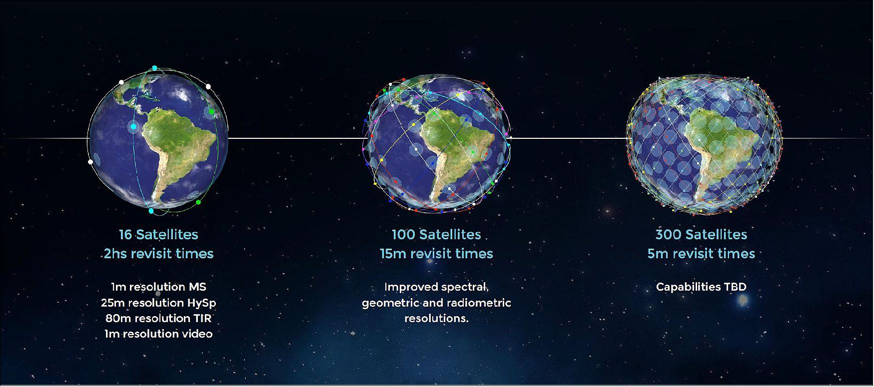
As of July 12, 2022, Satellogic NewSat satellites have achieved Multispectral imaging at resolutions of 0.7 m and up with a temporal resolution of seven times daily. A hyperspectral spatial resolution of 25 m has been achieved across 29 frequency bands (430 - 830 nm), with revisit times of 1-2 times daily. Lastly, monochromatic full-motion video capabilities have been achieved, with recordings of up to 60 seconds at 10 fps. The constellation is now able to capture in four different capture modes, which include strip mode, oblique strip mode, spotlight mode and tile mode.
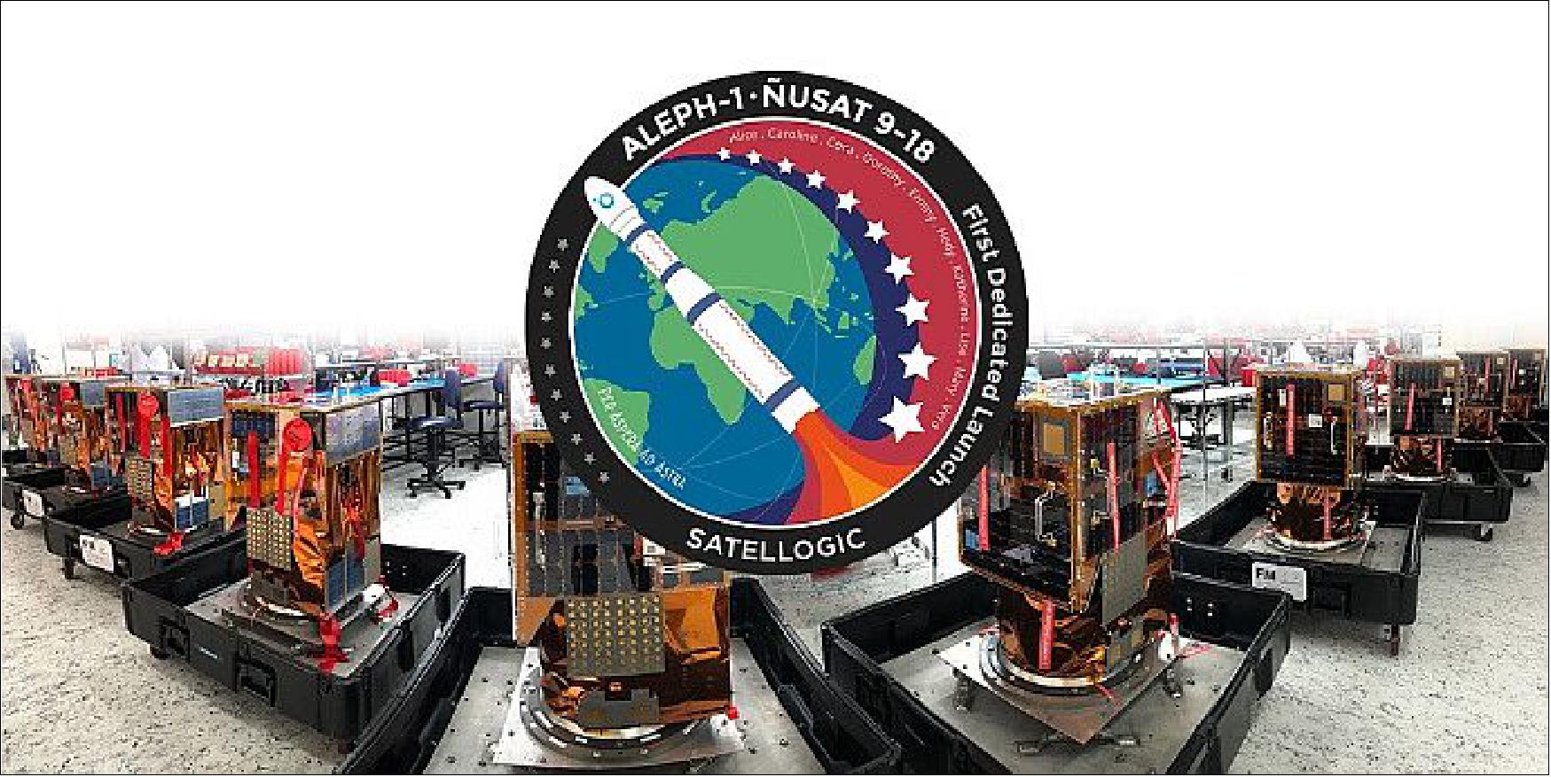
Ground Segment
• Svalbard of Norway is providing more than 10 passes per day, 2 antennas to support 2 satellites at the same time on polar orbits (Ref. 6).
• Cordoba, Argentina, located in the CONAE (Comision Nacional de Actividades Espaciales) facilities for NewSat-3, support for 6 passes per day (43 degrees).
References
1) Bringing space down to earth — Satellogic is building the first scalable earth observation platform with the ability to remap the entire planet at both high-frequency and high-resolution,” Satellogic, URL: https://satellogic.com/about/
2) Emiliano Kargieman, CEO of Satellogic, ”Drivers For The Wide Adoption Of Earth Observation,” SatMagazine, May 2020, URL: http://www.satmagazine.com/story.php?number=584789109
3) ”Satellogic Verically integrated geospatial analytics,” Satellogic, 2020, URL: https://satellogic.com/
4) ”ÑuSat,” URL: https://en.wikipedia.org/wiki/%C3%91uSat
5) ”Aleph-1 Satellite Constellation,” Spaceflight 101, URL: https://web.archive.org/web/20240616051319/https://spaceflight101.com/spacecraft/aleph-1/
6) Adrian Sinclair, ”Bringing space down to Earth,” Satellogic, 2017, URL: https://www.itu.int/en/ITU-R/space/workshops/2017-Bariloche/Presentations/30%20-%20Adrian%20Sinclair-%20Satellogic.pdf
7) ”Satellogic Announces Successful Launch of Four Additional Satellites on SpaceX Transporter-5 Mission,” Satellogic Press Release, 26 May 2022, URL: https://satellogic.com/news/press-releases/satellogic-announces-successful-launch-of-four-additional-satellites-on-spacex-transporter-5-mission/
8) Jeff Foust, ”Satellogic to launch 68 satellites with SpaceX,” SpaceNews, 4 May 2022, URL: https://spacenews.com/satellogic-to-launch-68-satellites-with-spacex/
9) Debra Werner, ”Orbital Insight brings Satellogic data into its platform,” SpaceNews, 25 April 2022, URL: https://spacenews.com/orbital-insight-satellogic-partnership/
10) ”Satellogic Launches Five Additional Satellites on SpaceX Transporter-4 Mission,” Satellogic, 4 April 2022, URL: https://satellogic.com/news/press-releases/satellogic-launches-five-additional-satellites-on-spacex-transporter-4-mission/
11) ”Satellogic Announces Upcoming Launch of Five New Satellites Onboard SpaceX Transporter-4 Mission, Satellogic Press Release, 10 March 2022, URL: https://satellogic.com/news/press-releases/satellogic-announces-upcoming-launch-of-five-new-satellites-onboard-spacex-transporter-4-mission/
12) Sandra Erwin, ”Satellogic names former chair of the Pentagon’s joint chiefs Joe Dunford to board of directors,” SpaceNews, 14 February 2022, URL: https://spacenews.com/satellogic-names-former-chair-of-the-pentagons-joint-chiefs-joe-dunford-to-board-of-directors/
13) Jeff Foust, ”Satellogic completes SPAC merger,” SpaceNews, 26 January 2022, URL: https://spacenews.com/satellogic-completes-spac-merger/
14) Jeff Foust, ”Satellogic raises $150 million from fund led by former treasury secretary,” SpaceNews, 19 January 2022, URL: https://spacenews.com/satellogic-raises-150-million-from-fund-led-by-former-treasury-secretary/
15) ”Satellogic Announces Development of High-Throughput Manufacturing Plant in the Netherlands,” Satellogic, 28 December 2021, URL: https://satellogic.com/news/press-releases/satellogic-announces-development-of-high-throughput-manufacturing-plant-in-the-netherlands/
16) Jeff Foust, ”Satellogic nearing completion of SPAC merger,” SpaceNews, 16 December 2021, URL: https://spacenews.com/satellogic-nearing-completion-of-spac-merger/
17) Sandra Erwin, ”Earth observation company Satellogic expands partnership with Amazon Web Services,” SpaceNews, 6 October 2021, URL: https://spacenews.com/earth-observation-company-satellogic-expands-partnership-with-amazon-web-services/
18) Jeff Foust, ”Satellogic to public through SPAC deal,” SpaceNews, 6 July 2021, URL: https://spacenews.com/satellogic-to-public-through-spac-deal/
19) ”Satellogic Launches 4 additional Satellites on SpaceX Falcon 9 Rocket,” Satellogic Press Release, 30 June 2021, URL: https://satellogic.com/news/press-releases/satellogic-launches-4-additional-satellites-on-spacex-falcon-9-rocket/
20) ”This image is provided in the Satellogic Gallery,” URL: https://satellogic.com/gallery/
21) ”Satellogic Partners With Four Major Space Organizations,” Satnews, 14 March 2021, URL: https://news.satnews.com/2021/03/14/satellogic-partners-with-four-major-space-organizations/
22) Sandra Erwin, ”Satellogic expanding U.S. footprint with eye on national security market,” SpaceNews, 11 March 2021, URL: https://spacenews.com/satellogic-expanding-u-s-footprint-with-eye-on-national-security-market/
23) Jeff Foust, ”Satellogic signs multi-launch contract with SpaceX,” SpaceNews, 20 January 2021, URL: https://spacenews.com/satellogic-signs-multi-launch-contract-with-spacex/
24) Rui C. Barbosa, ”Long March 6 lofts ten Argentinian satellites,” NASA Spaceflight.com, 6 November 2020, URL: https://www.nasaspaceflight.com/2020/11/long-march-6-lofts-ten-argentinian-satellites/
25) Andrew Jones, ”China launches 13 satellites on a single Long March 6 rocket,” Space.com, 6 November 2020, URL: https://www.space.com/china-long-march-6-rocket-launches-13-satellites
26) ”Satellogic’s Hypatia Smallsat Successfully Launched,” Satnews, 4 September, 2020, URL: https://news.satnews.com/2020/09/04/satellogics-hypatia-smallsat-successfully-launched/
27) ”With Vega, Arianespace successfully performs the first European mission to launch multiple small satellites,” Arianespace Press Release, 3 September 2020, URL: https://www.arianespace.com/press-release/with-vega-arianespace-successfully-performs-the-first-european-mission-to-launch-multiple-small-satellites/
28) ”Vega return to flight proves new rideshare service,” ESA Enabling & Support, 3 September 2020, URL: https://www.esa.int/Enabling_Support/Space_Transportation/Vega/Vega_return_to_flight_proves_new_rideshare_service
29) Jeff Foust, ”Satellogic raises $50 million to build out imaging constellation,” SpaceNews, 19 December 2019, URL: https://spacenews.com/satellogic-raises-50-million-to-build-out-imaging-constellation/
30) Jeff Foust, ”Satellogic signs deal to provide imagery service in China,” SpaceNews, 13 September 2019, URL: https://spacenews.com/satellogic-signs-deal-to-provide-imagery-service-in-china/
31) Stephen Clark, ”Chinese company inks deal to launch 90 commercial smallsats,” Spaceflight Now, 30 January 2019, URL: https://spaceflightnow.com/2019/01/30/chinese-company-inks-deal-to-launch-90-commercial-smallsats/
32) Maddy Longwell, ”Want satellite imagery but not satellites? This company can help,” C4ISRNET, 27 June 2018, URL: https://www.c4isrnet.com/c2-comms/satellites/2018/06/27/want-satellite-imagery-but-not-satellites-this-company-can-help/
33) Jeff Foust, ”Satellogic raises $27 million round for hyperspectral imaging constellation,” SpaceNews, June 2017, URL: https://spacenews.com/satellogic-raises-27-million-round-for-hyperspectral-imaging-constellation/
34) Gabriel Popkin, ”Earth-observing companies push for more-advanced science satellites,” Nature News, Vol. 545, 23 May 2017, https://pubmed.ncbi.nlm.nih.gov/28541338/, URL: https://www.nature.com/news/earth-observing-companies-push-for-more-advanced-science-satellites-1.22034
35) “Aleph-1 Constellation.” Satellogic, URL: https://satellogic.com/technology/constellation/
36) Satellogic, “Satellogic NewSat Satellite Re-Entry Strategy”, URL: https://satellogic.com/2023/09/05/satellogic-newsat-re-entry-strategy/
37) Satellogic, “Celebrating Women in STEM”, URL: https://satellogic.com/2021/08/10/celebrating-women-in-stem/
38) Gunter’s Space Page, “TSAT 1A”, URL: https://space.skyrocket.de/doc_sdat/tsat-1a.htm
39) SpaceX, “BANDWAGON-1 MISSION”, April 7, 2024, URL: https://www.spacex.com/launches/mission/?missionId=bandwagon-1
40) Majumdar, Oishee, “India's Tata launches Earth observation satellite”, Janes, April 8, 2024, URL: https://www.janes.com/defence-news/news-detail/indias-tata-launches-earth-observation-satellite
41) Dentz, Lenny, “SpaceX launches Transporter-10 rideshare from Vandenberg”, NasaSpaceFlight, March 4, 2024, URL: https://www.nasaspaceflight.com/2024/03/transporter-10/
42) Dentz, Lenny, “SpaceX Transporter-8 launches 72 payloads marking 200th booster landing”, NasaSpaceFlight, June 12, 2023, URL: https://www.nasaspaceflight.com/2023/06/spacex-transporter-8/
43) Dentz, Lenny, “SpaceX Transporter-7 launches 51 payloads, booster return to LZ”, NasaSpaceFlight, April 14, 2023, URL: https://www.nasaspaceflight.com/2023/04/spacex-transporter-7/
44) Gunter’s Space Page, “ÑuSat 1, ..., 98 (NewSat 1, ..., 98, Aleph-1 1, ..., 98)“, URL: https://space.skyrocket.de/doc_sdat/nusat-1.htm
Overview Spacecraft Launch Mission Status Sensor Complement Ground Segment References Back to top