Sentinel Asia Constellation
EO
Quick facts
Overview
| Mission type | EO |
Sentinel Asia Constellation
Sentinel Asia Activities References
The Sentinel Asia initiative is an international collaboration among space agencies, disaster management agencies, and international agencies for applying remote sensing and Web-GIS technologies to support disaster management in the Asia-Pacific region. Sentinel Asia is a voluntary initiative, a grass-roots and best-efforts-based collaboration, led by APRSAF (Asia-Pacific Regional Space Agency Forum). Its aims include the following: 1) 2)
• Improve safety in society through Information and Communication Technology (ICT) and space technologies
• Improve the speed and accuracy of disaster preparedness and early warning
• Minimize the number of victims and social/economic losses.
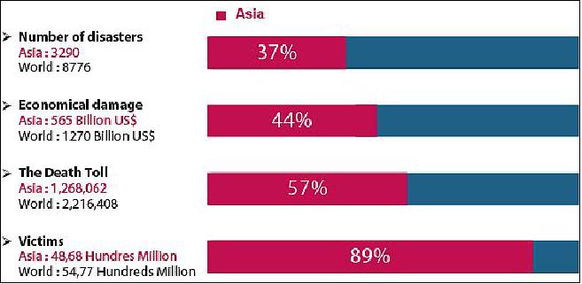
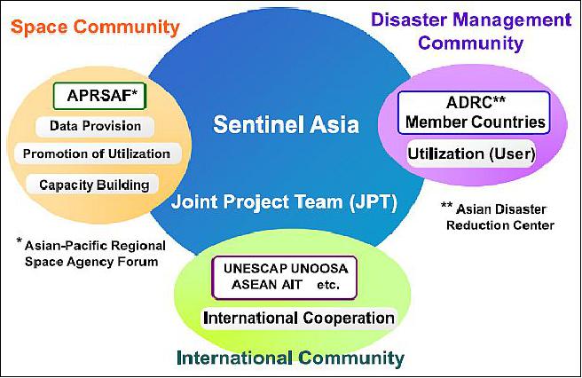
Background: According to statistics presented in the Natural Disasters Data Book 2013, a publication of ADRC (Asian Disaster Reduction Center), Asia has incurred serious damages from natural disasters over the last 30 years. The region sustained 48 percent of global fatalities from natural disasters and 89 percent of the total victims of such disasters. Therefore, APRSAF proposed Sentinel Asia in 2005 to showcase the value and impact of Earth observation technologies in combination with near realtime Internet dissemination methods and Web-GIS mapping tools for disaster management support in the Asia-Pacific region. Sentinel Asia is promoted by cooperating partners in the space community such as APRSAF, the international community—including UNESCAP United Nations Economic and Social Commission for Asia and the Pacific), UNOOSA (United Nations Office for Outer Space Affairs), ASEAN (Association of Southeast Asian Nations), and the Asian Institute of Technology (AIT)—and the disaster management community, including ADRC (Asian Disaster Reduction Center) and its member countries.
APRSAF was established in 1993 to enhance space activities in the Asia-Pacific region. Space agencies, governmental bodies, international organizations, private companies, universities, and research institutes from over 40 countries and regions take part in APRSAF, the largest space-related conference in the Asia-Pacific region. The increasing attendance of high-ranking officials at APRSAF events provides opportunities to discuss international cooperation for space activities in concrete terms. Australia, although a separate continent, is also a member of APRSAF with the partner organizations of CSIRO (Commonwealth Scientific and Industrial Research Organization), GA (Geoscience Australia) and the Australian Bureau of Meteorology.
APRSAF organizes four working groups: Space Applications, Space Technology, Space Environment Utilization, and Space Education—to share information about the activities and future plans of each country and region in these respective areas. APRSAF also supports the establishment of international projects as solutions for common issues, such as disaster management and environmental protection, so that participating parties will benefit from mutual cooperation.
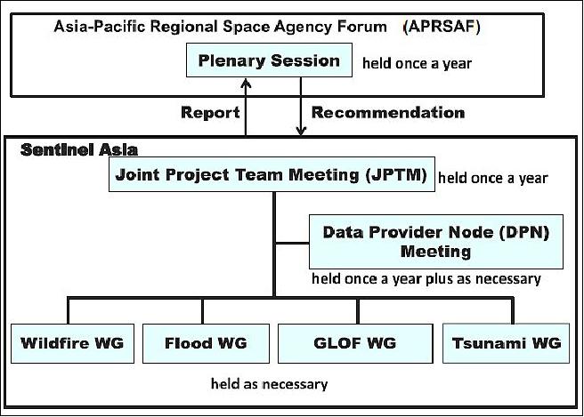
Sentinel Asia Activities
The main activities of Sentinel Asia are as follows:
• Emergency observation by Earth observation satellites upon request in cases of major disasters
• Working group activities focusing on specific disasters such as wildfire, flood, glacial lake outburst flood (GLOF), and tsunami
• Capacity building and human resources development for effective disaster management.
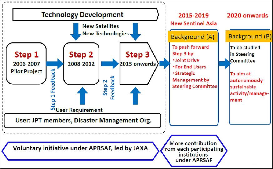
A step-by-step approach was adopted for the implementation of Sentinel Asia as follows:
Step 1
Implementation of the data dissemination system as a pilot project to form the backbone of Sentinel Asia and showcase the value and impact of technology using standard Internet dissemination systems (2006–2007).
Emergency Observation: In Step 1, JAXA's ALOS (Advanced Land Observing Satellite) and Indian Remote Sensing Satellites (IRS) of ISRO (Indian Space Research Organization) have carried out emergency observations in the case of major disasters in the Asia-Pacific region. Emergency observation requests of the JPT (Joint Project Team) members and ADRC members are passed to space agencies through the ADRC. 5)
The decision to move forward in implementation of the Sentinel Asia system and associated partner network was made soon after the Indian Ocean tsunami disaster on Dec. 26,2004, to fast-track this project, and to complement current space and ground infrastructure in the region with a fast distribution system of disaster-related earth observation information to relevant agencies and the general public throughout the region (Ref. 3).
The technical concept was finalized at a meeting in May 2005 in Kuala Lumpur, hosted by MACRES (Malaysian Center for Remote Sensing), and was promptly approved as a project for rapid implementation by the APRSAF-12 plenary held in Kitakyushu, Japan, in October 2005, with the adoption of the following recommendations:
1) To strengthen international cooperation and take concrete actions toward the establishment of a disaster risk management system within the framework of APRSAF, recognizing the timeliness of establishing such a system with the participation of as many entities as possible, such as space agencies, disaster management agencies, as well as relevant regional and international entities.
2) To take concrete steps toward the establishment of the above disaster risk management system, and as the first step, to implement the "Sentinel Asia" pilot project through the formation of a "Joint Project Team" (JPT) at the earliest possible date, in order to refine the details of project implementation. The JPT secretariat is located at JAXA.
As a result, the 1st JPT meeting of Sentinel Asia Step 1 was held in February 2006, in Hanoi, Vietnam, hosted by VAST (Vietnamese Academy of Science and Technology), and Step 1 was launched.

Step 2
Expansion of the dissemination backbone with new satellite communication systems and enhancement of activities based on requirements and experiences acquired during Step 1 (2008–2012). Installation of an information -sharing platform: The Step 2 system adopts the idea of local mirroring, and transfers data from Japan Central Sever to users' local mirrored server not only via Internet but also via the JAXA communication satellite, WINDS (Wideband InterNetworking engineering test and Demonstration Satellite) / Kizuna. WINDS was launched on Feb. 23, 2008.
Regional servers were installed during the Step 2 phase in order to deliver disaster information and to transfer satellite data permitted by the data providers to the users as local mirror be the WINDS satellite and Internet. About 155 Mbit/s of high speed communication is provided by WINDS to overcome the narrow-band problem in the Asia-Pacific region; hence, users can immediately access exactly to the same service functions, such as web-page and Web-GIS, provided by the Japan Central Server for the regional servers.
As of 2015, there are 12 regional servers in the Asia-Pacific region including: GISTDA in Thailand, NSPO-NARLabs (with Internet only) in Taiwan, ICIMOD (International Center for Integrated Mountain Development) in Nepal, LAPAN (National Institute of Aeronautics and Space), Jakarta, Indonesia, CAIAG (Central-Asian Institute for Applied Geosciences) in Bishek, Kyrgyzstan, SPARRSO (Bangladesh Space Research and Remote Sensing Organization) in Bangladesh, ANGKASA (National Space Agency of Malaysia),Kuala Lumpur, Malaysia, and others.

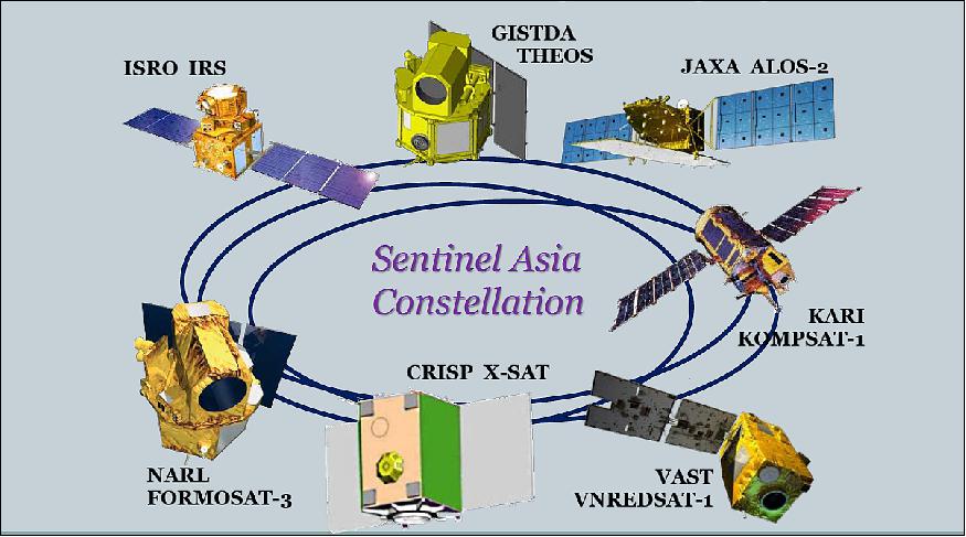
DPN (Data Provider Node): In the case of a regional disaster, several regional space agencies and related institutions act as DPNs, providing satellite data from their own national satellites to the DAN (Data Analysis Node) at the explicit request of a JPT member or ADRC member, to the extent permitted by the data policy of each DPN. DPN members include JAXA, ISRO (Indian Space Research Organization) of India, KARI (Korea Aerospace Research Institute) of Korea, GISTDA ( Geo-Informatics and Space Technology Development Agency ) of Thailand, the NSPO-NARL (National Applied Research Laboratories ) of Taiwan, and CRISP (Center for Remote Imaging, Sensing and Processing) at the National University of Singapore. DPN's satellites are called the "Sentinel Asia Constellation."
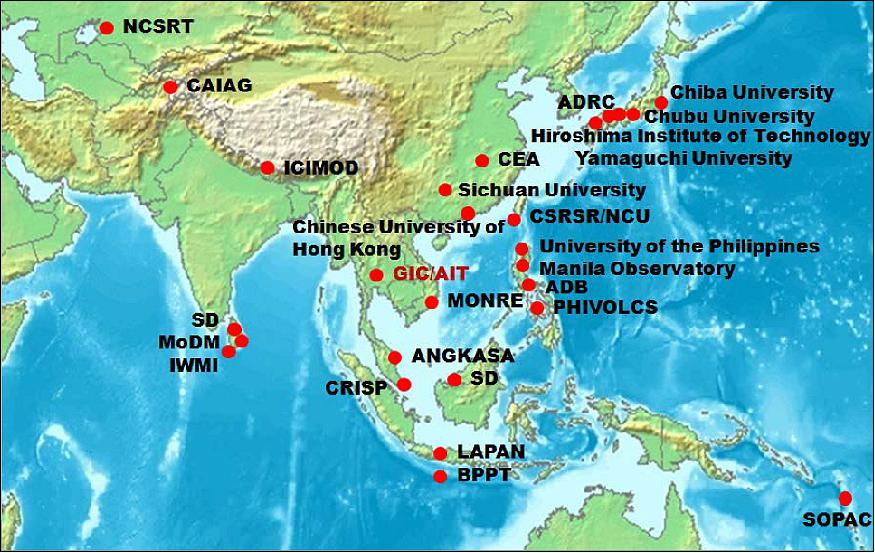
DAN (Data Analysis Node): A new framework of satellite data analysis and value-adding was subsequently established in Step 2 of Sentinel Asia, since it was quickly realized that merely providing satellite data may not be as useful to many emergency and disaster agencies that would rather prefer more advanced "information products" derived from the data for their uses. The DANs of Sentinel Asia were organized to provide some level of data analysis and pre-processing to the satellite images provided by the DPNs, to make it easier for disaster management agencies to obtain easily comprehensible interpretations of available images. In the case of an emergency observation, the DAN members analyze the satellite data (in GeoTIFF format, or raw data in principle) provided by the DPN, together with their own data, such as local maps, and then make value-added products, and deliver such "disaster information products", where possible in near-realtime. One of these nodes is nominated to be the Primary Data Analysis Node (P-DAN), and thus has the additional responsibility of data analysis management: coordinating the response of all other DANs to each emergency observation request. The Asian Institute of Technology (AIT) in Thailand is currently the P-DAN (also referred to as PDAN). 6)
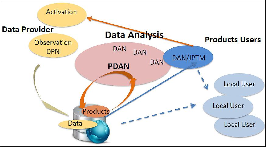
Current DPN and DAN members are listed in Table 1.
Step 3
Support for mitigation/preparedness and response and recovery activities through utilization of many and various satellites, including Earth observation, communications, and navigation satellites, based on the human network and further joint operation by the Joint Project Team (2013–present).
As Sentinel Asia evolves to activate and reinforce its expected functions, a steering committee will be established to ensure that the development plan consists of three concepts: joint drive, end-user- orientation, and strategic management.
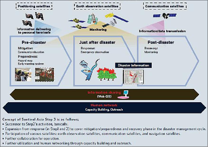
The main products provided by Sentinel Asia are as follows:
• Satellite imagery (and data permitted by data provider) and value-added images with extraction of stricken area, etc.
• On-site digital camera images
• Rainfall (short-term and long-term) information and data
• Meteorological satellite imagery and data.
Country / region | Organization | DPN | DAN |
Australia | CSIRO (Commonwealth Scientific and Industrial Research Organization) |
|
|
Bangladesh | SPARRSO (Bangladesh Space Research and Remote Sensing Organization) |
|
|
Bhutan | Department of Survey and Land Records |
|
|
Brunei | Survey Department, Ministry of Development |
| ∨ |
Cambodia | Ministry of Land Management, Urban Planning and Construction |
|
|
China | NDRCC (National Disaster Reduction Center of China) |
|
|
Fiji | Fiji National Disaster Management Office (NDMO) |
|
|
India | ISRO (Indian Space Research Organization) | ∨ | ∨ |
Indonesia | BNPB (National Disaster Management Agency) |
|
|
Japan | Keio University |
|
|
Kazakhstan | NCSRT (National Center of Space Researches and Technologies) |
| ∨ |
Korea | KARI (Korea Aerospace Research Institute) | ∨ | ∨ |
Kyrgyzstan | CAIAG (Central Asian Institute of Applied Geosciences) |
| ∨ |
Lao P.D.R. | Ministry of Labor and Social Welfare |
|
|
Malaysia | National Security Division, Prime Minister's Department |
|
|
Mongolia | NRSC (National Remote Sensing Center) of Mongolia |
|
|
Myanmar | Department of Meteorology and Hydrology |
|
|
Nepal | Survey Department of Nepal |
|
|
Pakistan | SUPARCO (Pakistan Space & Upper Atmosphere Research Commission) |
|
|
Philippines | NDRRMC (National Disaster Risk Reduction and Management Council), OCD (Office of Civil Defense) |
|
|
Singapore | CRISP (Center for Remote Imaging, Sensing and Processing), National University of Singapore | ∨ | ∨ |
Sri Lanka | Survey Department of Sri Lanka |
| ∨ |
Taiwan | NARL (National Applied Research Laboratories) also referred to as NSPO-NARLabs | ∨ | ∨ |
Thailand | GISTDA (Geo-Informatics and Space Technology Development Agency) | ∨ | ∨ |
Vietnam | VAST (Vietnamese Academy of Science and Technology) |
|
|
International | GIS/AIT (Geo Informatics Center / Asian Institute of Technology), Thailand |
| ∨ |
The ADB (Asian Development Bank), located in Manila, the Philippines, supports developing countries in Asia and the Pacific region in applying spaceborne technology with the support of JAXA (Japan Aerospace Exploration Agency). ADB is a regional development bank to facilitate economic development and poverty reduction in development member countries in Asia and the Pacific. Based on understanding that Earth observation is useful for the development of member countries in various sectors including disaster risk management, ADB has been using spaceborne technology applications actively and became a member of Sentinel Asia in 2012. From April 2012 to March 2015, ADB with the support of JAXA conducted the regional capacity development project entitled "Applying Remote Sensing Technology in River Basin Management". This project supported flood management agencies in Bangladesh, the Philippines and Vietnam to apply satellite-based rainfall data. From April 2015, ADB with the support of JAXA started the regional capacity development project entitled "Applying Space-Based Technology and Information and Communication Technology to Strengthen Disaster Resilience". This project will support Armenia, Bangladesh, Philippines and Fiji to introduce satellite-based damage assessment and GPS-equipped mobile phones for data collection for disaster management at the local level. 7)
As of fall 2015, Earth observation satellites from JAXA (Japan Space Exploration Agency) of Japan, ISRO (Indian Space Research Organization) of India, NSPO-NARLabs (National Space Organization-National Applied Research Laboratories) of Taiwan, CRISP (Center for Remote Imaging, Sensing and Processing) of Singapore, GISTDA (Geo-Informatics and Space Technology Development Agency) of Thailand and KARI (Korea Aerospace Research Institute) constitute the Sentinel Asia Constellation of today. 8)
Activities include emergency observation response, data provision, analysis, sharing and capacity building. As it is evolving, activities will be extended to mitigation/preparedness and recovery phases, more working groups will be formed in different scenarios of wildfire, flood, GLOF (Glacial Lake Outburst Flood), tsunami and drought. Members agreed to adopt the plan to involve end-users by a joint drive with not only government level, but community level. In the meantime, Sentinel Asia is collaborating with international organizations such as the Asian Development Bank to conduct Success Story to solve the region's critical issues.
In the Step 3 phase, the Sentinel Asia Constellation consists of 6 Earth observation satellites, these are:
• FormoSat-2 of NSPO-NARLabs, launch: May 20, 2004.
• ALOS-2 (Advanced Land Observing Satellite-2) of JAXA, Japan, launch: May 24, 2014.
• KOMPSAT-1 (Korean Multi-Purpose Satellite-1) of KARI, Korea, launch: Dec. 20, 1999 (KARI lost contact with KOMPSAT-1 in December 2007). As of Jan. 31, 2008 the KOMPSAT-1/Arirang-1 mission was officially retired.
• THEOS (Thai Earth Observation System) of GISTDA, Thailand, launch: October 1, 2008.
• XSAT (or X-Sat) of CRISP, Singapore, launch: April 20, 2011.
• ResourceSat-1 [formerly IRS-P6 (Indian Remote Sensing Satellite)] of ISRO, India, launch: October 17, 2003.
Satellite | FormoSat-2 | ALOS-2 | KOMPSAT-1 | THEOS | XSAT | ResourceSat-1 |
Operator | NSPO-NARLabs | JAXA (SAT data) | KARI | GISTDA | CRISP | ISRO |
Sensor/GSD | 1 Pan / 2 m | Spotlight / 1 m x 3 m | EOC / 6.6 m | 1 Pan/ 2 m | 3 MS / 12 m | LISS-4 / 5.8 m |
Swath width (km) | 24 | Spotlight / 25 x 25 | EOC (17) | Pan (22) | 50 | LISS-4 / Pan (23.9); |
Repeat cycle (days) | Daily | 14 | 28 | 26 | 28 | LISS-4 (5) |
EOC (Electro-Optical Camera); OSMI (Ocean Scanning Multispectral Imager); LISS (Linear Imaging Self-Scanning Sensor); AWiFS (Advanced Wide Field Sensor) | ||||||
NRO-NARLabs joint the Sentinel Asia Step 2 in 2010 as a DPN (Data Provider Node) and DAN (Data Analysis Node).
As Sentinel Asia is evolving, the expansion of activity to disaster response to cover the preparedness/mitigation and recovery phase is being proposed. Under the Sentinel Asia framework, collaboration between NSPO-NARLabs and JAXA was conceived to utilize the spaceborne optical (FormoSat-2) and SAR (Synthetic Aperture Radar) data of ALOS-2 in not only emergency observation response, but also in pre-and post-disaster phases. The project will contain activities of rapid response to disasters in the affected regions, and long-term monitoring for some selected areas where disasters happen frequently or potential catastrophic disasters are expected. This collaboration will be used as a showcase of SASS (Sentinel Asia Success Story).
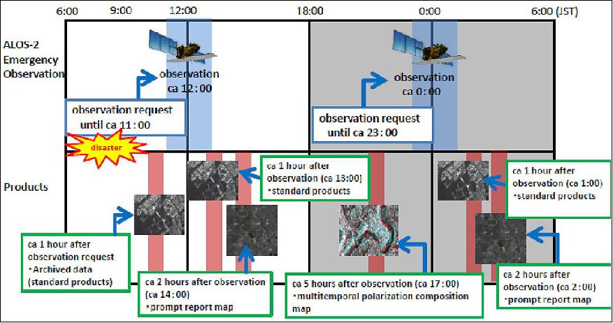
Figures 11 and 12 describe the process and timeline of operations in response to disasters. The aim of this SASS is to build up a rapid response system as a showcase by complementary utilization of FormoSat-2 and ALOS-2. A reference map will be first scheduled and generated, and coordination of operations in case of emergency observation between the institutes, including image data provision and analysis, will have to be implemented.
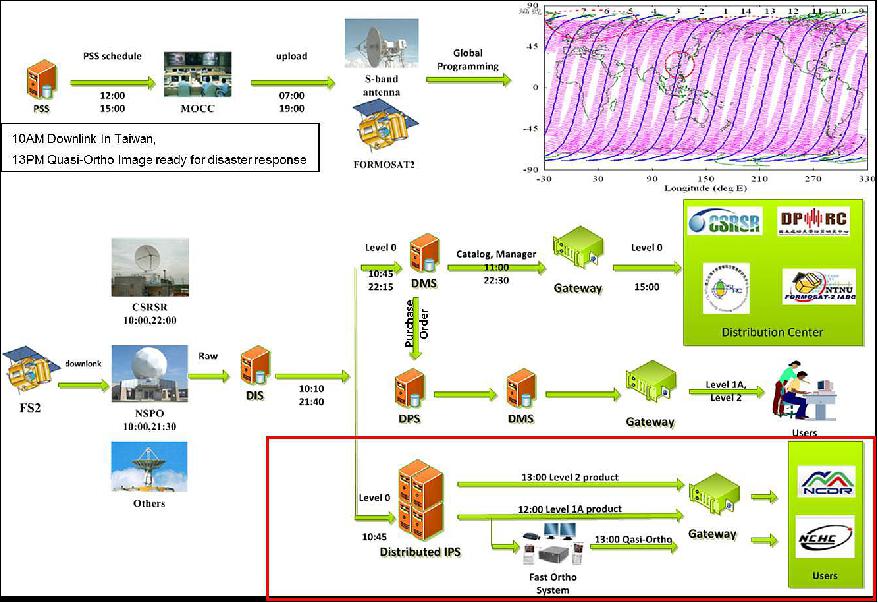
ALOS-2 can handle an emergency observation request one hour prior to the most recent time of observation. For disasters in Japan, data can be provided within 12 hours according to the ALOS-2 press kit.
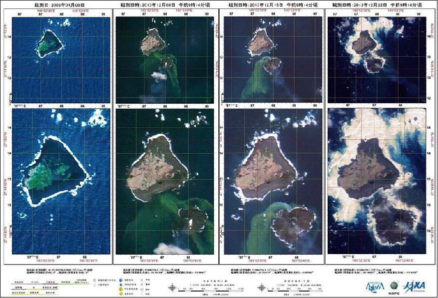
In planning this SASS, ad hoc activities include monitoring of sudden events such as volcano eruption as well as support drills are also considered. An example in monitoring is the eruption of the volcano on Nishinoshima in December 2013. Figure 13 shows the process that a new island was formed in this event. NSPO provided tasking support as a response to request to participate in a disaster drill in Japan, conducted by the Cyugoku Regional Development Bureau, Ministry of Land Infrastructure, Transport and Tourism on Sept. 2, 2013. Specifically, FormoSat-2 made observations in the coastal area of Shimane Prefecture. FormoSat-2 also supported the disaster prevention drill by providing tasking images on February 18-20 and on February 26-28, 2014 at Inawashiro, Fukushima. The drill was planned by the Japan Medical Association.
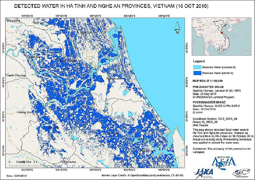
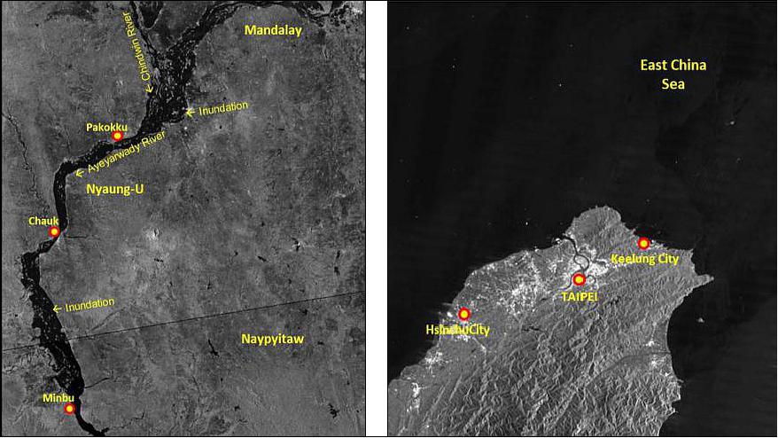
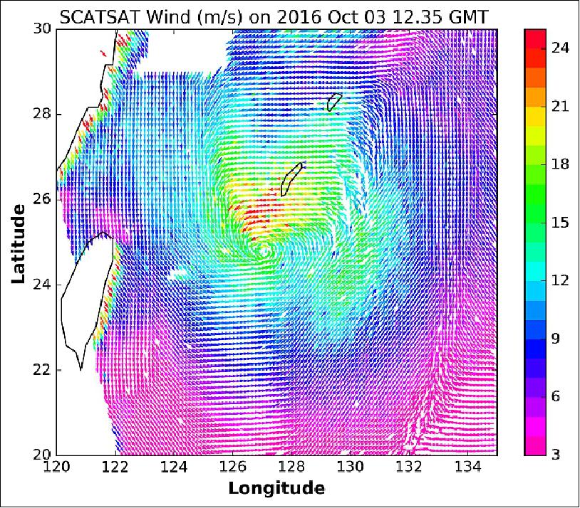
ALOS-2 was launched in May 2014, since then, it has supported 3 disaster events, including floods in Kaohsiung, Fung Wong Typhoon, and the rescue of the Ocean Research Vessel-V.
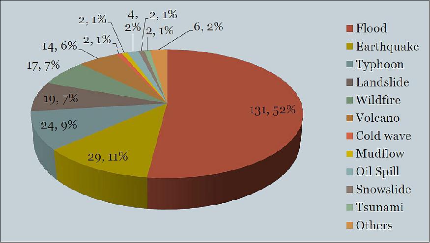
FormoSat-2 was launched in 2014, during its 11 years on orbit, the images are applied to various areas of social benefit. In 2014, there were 19 activations of EORs (Emergency Observation Requests) of Sentinel Asia. NSPO made 11 responses, resulting in the delivery of 85 scenes of FormoSat-2 in the effected areas. The follow-on mission of FormoSat-2 is FormoSat-5 which is scheduled for launch in Q1 2016.

References
1) "Sentinel-Asia: Disaster Management Support System In The Asia-Pacific Region," APRSAF, 2013, URL: https://www.aprsaf.org/initiatives/sentinel_asia/
2) "Sentinel Asia," JAXA, 2009, URL: https://sentinel.tksc.jaxa.jp/sentinel2/MB_HTML/About/About.htm
3) Kazuya Kaku, Alexander Held, "Sentinel Asia: A space-based disaster management support system in the Asia-Pacific region," Elsevier, International Journal of Disaster Risk Reduction, Volume 6, December 2013, Pages: 1–17, URL: http://www.sciencedirect.com/science/article/pii/S2212420913000411/pdfft?md5=747b98159474c4bac8bef8a0d6196c4f&pid=1-s2.0-S2212420913000411-main.pdf
4) Rio Tanabe, "Sentinel Asia Overview," The 23rd Session of the Asia-Pacific Regional Space Agency Forum (APRSAF-23), Manila, the Philippines, November 15-18, 2016, URL: http://www.aprsaf.org/annual_meetings/aprsaf23/pdf/working_groups/sawg/AP23_SA_Day1_1045.pdf
5) K. Kaku, A. Ono, M. Kawai, ""Sentinel Asia Step 2 — The Overview and Evolution from Step 1," International Archives of the Photogrammetry, Remote Sensing and Spatial Information Science, Volume XXXVIII, Part 8, Kyoto Japan 2010, URL: http://www.isprs.org/proceedings/XXXVIII/part8/pdf/JTS35_20100301164014.pdf
6) Lal Samarakoon, "PDAN Activities and Future Plans to enhance the utilization of Sentinel Asia system," The 23rd Session of the Asia-Pacific Regional Space Agency Forum (APRSAF-23), Manila, the Philippines, November 15-18, 2016, URL: http://www.aprsaf.org/annual_meetings/aprsaf23/pdf/working_groups/sawg/AP23_SA_Day1_1115.pdf
7) Yusuke Muraki, Tadayoshi Yahata, "Space-based technology applications for disaster management in Asian Development Bank projects," Proceedings of the 66th International Astronautical Congress (IAC 2015), Jerusalem, Israel, Oct.12-16, 2015, paper: IAC-15-E5.5.9
8) Ming-Chih Cheng, Kazuya Kaku, Yu-Ching Liu, Takehisa Chiba, Bo Chen, Shiann-Jeng Yu, Guey-Shin Chang, "Taiwan's FormoSat Satellites in Responses to Asia Pacific Regional Disasters with Sentinel Asia," Proceedings of the 66th International Astronautical Congress (IAC 2015), Jerusalem, Israel, Oct.12-16, 2015, paper: IAC-15-B1.1.6
9) Makoto Ikeda, "Trend of Emergency Observation Requests in the past decade," The 23rd Session of the Asia-Pacific Regional Space Agency Forum (APRSAF-23), Manila, the Philippines, November 15-18, 2016, URL: http://www.aprsaf.org/annual_meetings/aprsaf23/pdf/working_groups/sawg/AP23_SA_Day1_1105.pdf
10) Rajeev Jaiswal, "ISRO's support for Sentinel Asia and other disaster management activities in 2016," The 23rd Session of the Asia-Pacific Regional Space Agency Forum (APRSAF-23), Manila, the Philippines, November 15-18, 2016, URL: http://www.aprsaf.org/annual_meetings/aprsaf23/pdf/working_groups/sawg/AP23_SA_Day1_1135.pdf
The information compiled and edited in this article was provided by Herbert J. Kramer from his documentation of: "Observation of the Earth and Its Environment: Survey of Missions and Sensors" (Springer Verlag) as well as many other sources after the publication of the 4th edition in 2002. - Comments and corrections to this article are always welcome for further updates (eoportal@symbios.space).