Spacety MiniSAR Constellation
EO
Quick facts
Overview
| Mission type | EO |
Spacety MiniSAR Constellation
Spacecraft Launch Mission Status Payload References
Spacety , a commercial company of Beijing and Luxembourg, is developing and deploying a unique SAR constellation on minisatellites with both C-band and X-band radar. This constellation will provide real-time imagery of every point on Earth day and night, rain or shine. The dual-band SAR constellation has very short revisit time and will enable many new applications not possible with single frequency band SAR data. 1)
Spacety is a global new space company specialized in small satellites and satellite-based services. Using our low-cost and high-performance CubeSat and minisatellite fleet, we provide Satellites-as-a-Service (SataaS) to support science, technology demonstration, and commercial services with fast, frequent, and flexible space flights. Our SAR (Synthetic Aperture Radar) constellation will monitor and observe the Earth day and night, and rain or shine. This Data-as-a-Service (DaaS) will make SAR imagery of every point on Earth accessible and affordable to end users all around the world.
Synthetic Aperture Radars (SAR) are basically like a bat – not affected by daylight and weather conditions compared to optical sensors. Now the era of SAR satellites has arrived, and Spacety is planning to build, launch and operate a constellation of 56 small SAR satellites. “Hisea-1 is the first launched satellite of TY-MINISAR, the first generation of light and small SAR satellites being developed by Spacety. The constellation based on TY-MINISAR benefits from low cost, fast deployment, strong coverage capability with a high revisit frequency, and flexible scheduling. As a result, the constellation can produce images of high resolution, wide-coverage, and continuous monitoring, and will provide customers with more efficient remote sensing services”, says Justin Feng, the founder and CEO of Spacety. Hisea-1 has a mass of 185 kg, and uses phased-array antenna. It has three imaging modes with the finest resolution of 1m x 1m. 2)
About Spacety
Spacety is a fast-growing company providing satellite-based services globally. It was founded by its CEO, Justin Feng, and its CTO, Ren Weijia in China in 2016. It established its international headquarters in Luxembourg in 2019. A world leader in CubeSats and smallsats, it has developed, launched, and operates 21 satellites for science and technology demonstration missions. As a leading provider of satellite-based services, it provides fast, frequent, flexible, and low-cost space missions with its advanced and reliable small satellite fleet. These space missions support science experiments or observation, and in-orbit demonstrations and/or validations of space technologies and products, or space systems. Those quick turnaround and end-to-end services have enabled world class space research and helped innovative space technologies to gain space heritage. Spacety is building and deploying a microwave-based (Synthetic Aperture Radar) satellite Earth Observation constellation to provide the world with global coverage and real-time imagery data as a service (DaaS). This C-band SAR constellation will monitor and observe the Earth, day and night, rain or shine, and make SAR imagery of every point on Earth accessible and affordable to users. The SAR data will be distributed worldwide and will enable innovative solutions to manage our changing world and make it better.
Still a young new space company, Spacety has already launched 21 satellites with 12 launches in less than 5 years. More satellites are expected to go to space in 2021 for the SAR constellation and also to provide IOD/IOV (In-Orbit Demonstration/Validation) and satellite hosting services to clients.
More background: In 2020, Spacety is one of the first private space companies in China, a small satellite maker with offices in Beijing and Changsha, in central China. Its founders were in part inspired by the activities of SpaceX and Planet. They left their jobs at institutes under the Chinese Academy of Sciences (CAS), a state-owned entity with a measure of space-related activities, to establish Spacety in January 2016. 3)
They did not, like many other satellite startups, start with plans to create their own constellations. Instead, Spacety offers a complete range of services for small satellites—including manufacturing, payload hosting, launch, and on-orbit operating. Such services allow Spacety’s clients to rapidly reach orbit so they can provide their own services, test new technologies, or carry out experiments.
The firm has so far been involved in 10 launches and seen 18 satellites reach orbit. Spacety provides small satellite platforms with masses of 10, 20 to 50 kg, and 200 kg. Clients include governments, research institutes, universities, and commercial companies, says CEO Feng Yang. The company has received several rounds of venture capital funding totaling about US $36 million.
Yang says Spacety has several missions planned for 2020, with most set for the second half of the year. In December, Spacety signed an agreement with Chinese private rocket company Landspace for a ride on the first launch of the Zhuque-2 launch vehicle in 2021.
One of the major concerns created by the explosion of small satellite activity is space debris. A satellite from SpaceX's Starlink Internet megaconstellation, which could grow to include thousands of satellites, recently came close to hitting a European satellite.
CubeSats are typically too small to have their own propulsion and thus lack any means to maneuver out of the way of debris or deorbit themselves after their mission lifetimes. Defunct spacecraft, each traveling at speeds of more than seven kilometers per second, remain in orbit and increase the likelihood of future collisions—which would create yet more debris.
In what could be a promising step toward addressing this problem, Spacety has partnered with ThrustMe, a French space propulsion startup to test light, inexpensive solid ion thrusters for CubeSats and small satellites to provide a measure of maneuverability. Notably the mission took just eight months from signing the contract to launch of the first Spacety satellite to incorporate these thrusters.
Spacety is now moving to develop its own payloads for its satellites. The company’s MiniSAR is a synthetic-aperture radar (SAR) satellite with a mass of about 150 kg that can provide images with a resolution of 1 meter per pixel. This follows the lead of Finnish startup ICEYE, which already has small high performance SAR satellites in orbit.
“MiniSAR is a challenge to us, because it is our first mini-SAR with high performance. We are implementing many innovative new designs in this satellite, and how to minimize the risks to have a successful mission is a challenge,” says Yang. MiniSAR is scheduled for launch in the third quarter of 2020.
Spacety is now looking to expand its engagement with European firms. In September, the company set up a subsidiary in Luxembourg. While U.S. firms are prohibited from launching on Chinese rockets, Spacety is considering launching on Indian rockets to circumvent such issues. Clearly, in this ‘NewSpace’ era, opportunities abound.
To do more exploration at a lower cost, the Chinese government has initiated policies aimed at establishing a private space industry like the one that exists in the United States, where companies such as SpaceX, Blue Origin, and Rocket Lab are bringing low-cost launch services to the space sector. 4)
In 2014, China’s State Council issued a proposal called Document 60 that would open the nation’s launch and small satellite sectors to private capital. The government followed this announcement with helpful policies, including a national civil-military integration strategy to transfer crucial, complex, and sensitive technologies from state-owned space sector giants to startups approved by authorities.
Today (2019), more than 10 private launch companies in China are working on launch vehicles or their components, and four are now prepared to make their first attempts to reach orbit.
Company | Founded | Launch vehicle | Propellant | Payload to orbit | First launch |
iSpace | 2016 | Hyperbola-1 | Solid | 300 km to 300 km LEO | April 2019 |
Landspace | 2015 | Zhuque-1 | Solid | 300 km to 300 km LEO | October 2018 (failed) |
Zhuque-2 | Liquid | 4,000 kg to 200 km LEO | planned for 2020 | ||
Linkspace | 2014 | NewLine-1 | Liquid | 200 kg to 500 km SSO | 2021 |
OneSpace | 2015 | OS-M1 | Solid | 205 kg to 300 km LEO | March 2019 (failed) |
SAR Spacecraft
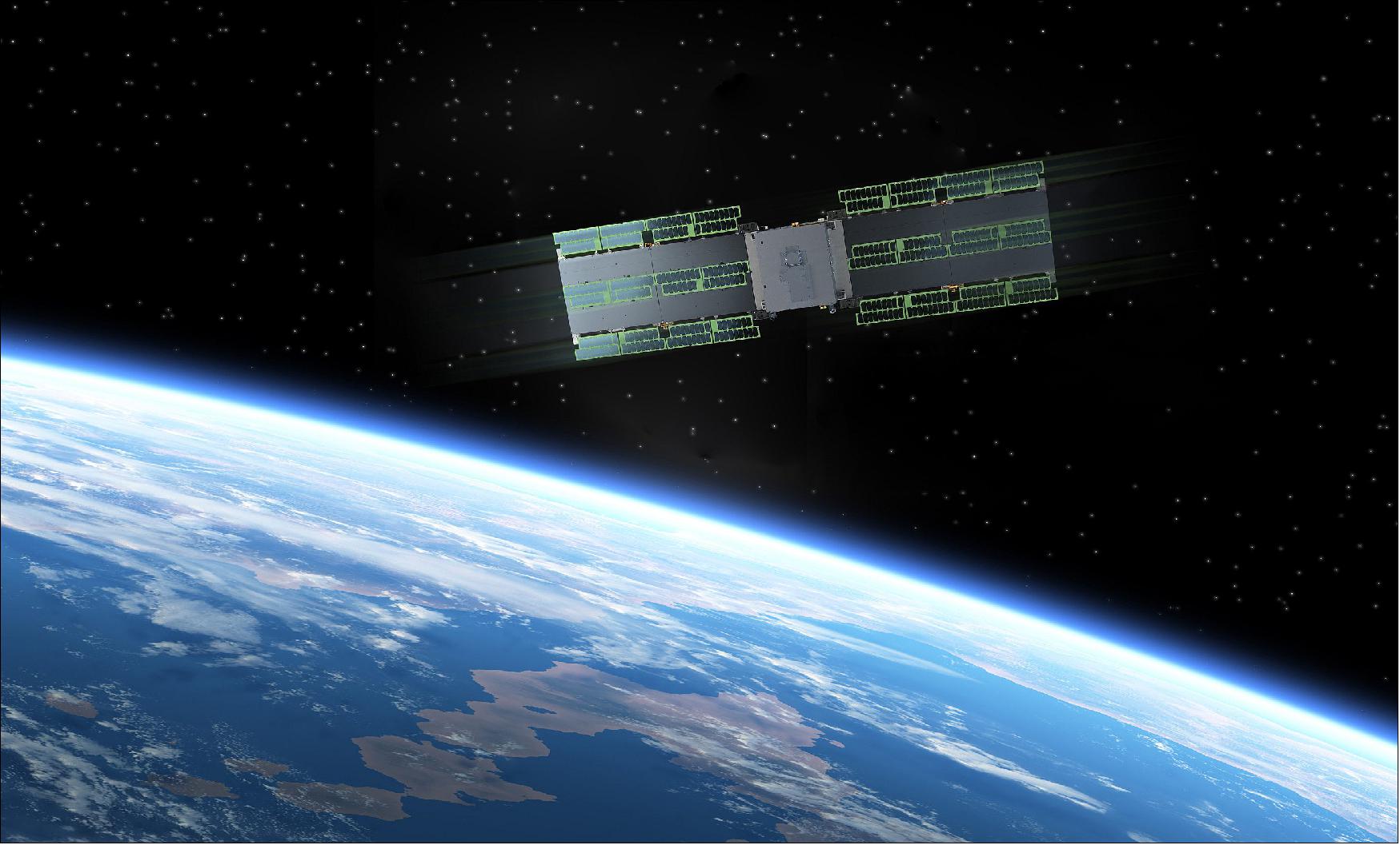
Spacety is developing and deploying a unique SAR constellation with both C-band and X-band radar. The dual-band SAR constellation has very short revisit times and will enable many new applications not possible with single frequency band SAR data. The HISEA-1 is the world’s first commercial C-band small satellite SAR with a phased-array antenna and a mass of 185 kg. carrying . Hisea-1 relies on ThrustMe's Iodine Electric Propulsion system for orbit maintenance, collision avoidance and de-orbiting at the end of its life. China's HISEA-1 was jointly developed by the 38th Research Institute CETC (China Electronics Technology Group Corporation), and SPACETY at the request of Xiamen University. 5)
Launch: On 21 December 2020 (04:37 UTC — or 12:37 p.m. on 22 December Beijing Time), China successfully carried out a first launch of the new Long March 8 (LZ-8) medium-lift rocket, marking a small step towards Chinese rocket reusability. LZ-8 placed five payloads into orbit on its first mission, debuting an expendable booster intended to eventually be outfitted for recovery and reuse. 6) 7) 8)
Spacety announces a new space launch, merely 6 weeks after the previous launch. On 22 December, two of Spacety’s satellites, Hisea-1 and Yuanguang, were successfully launched (as secondary payloads) into space on the inaugural flight of the medium-lift Long March 8 (LZ-8) rocket, from Wenchang, China. Hisea-1 is Spacety’s first commercial Synthetic Aperture Radar (SAR) satellite, which is also the world’s first commercial C-band small satellite SAR with a phased-array antenna. Yuanguang is a 12U satellite for scientific experiments of mechanism and tribology in space.
Orbit: On its debut mission, the Long March 8 lifted off from Hainan Island and jettisoned its first stage and side boosters a few minutes into the flight. The second stage engines injected five payloads into an SSO roughly 500 km above Earth, with an inclination of 97.4º to the equator.
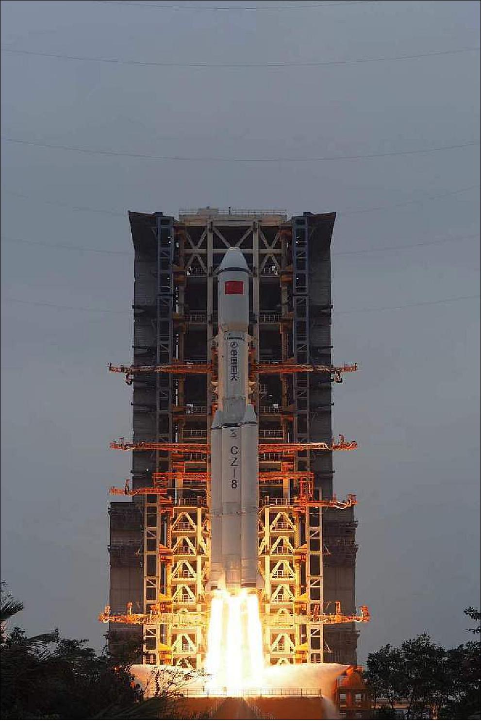
Payloads of the LZ-8 mission
• The Long March 8’s payloads included a top secret Chinese “technology verification satellite” , developed at CAST, named Xinjishu Yanzheng-7 (XJY-7), the largest of the five satellite passengers on-board.
• Hisea-1 (also spelled Haisi-1), a 180 kg SAR minisatellite of the Chinese space company Spacety for commercial Earth observation in C-band with a phased-array antenna.
• Yuanguang (20 kg), an experiment hosting 12U CubeSat of Spacety and HBUT (Hubei University of Technology)
• The Tianqi 8 data relay satellite to join a fleet of orbiting relay stations designed for IoT (Internet of Things) services. The Tianqi constellation is owned by Guodian Gaoke, a Beijing-based company.
• ET-SMART-RSS, a 6U CubeSat (9 kg) jointly developed by engineers at the Ethiopian Space Science and Technology Institute and Beijing Smart Satellite Space Technology Co. Ltd. The Chinese-funded CubeSat provide Earth observation data for users in Ethiopia and China. Ethiopian officials said the partnership will strengthen ties between Ethiopia in “human development” and “technology transfer,” according to China’s Xinhua news agency.
Now the era of SAR satellites has come, and Spacety is planning a constellation of 56 small satellites. “Hisea-1 is the first launched satellite of TY-MINISAR, the first generation of light and small SAR satellites being developed by Spacety. The constellation based on TY-MINISAR benefits from low cost, fast deployment, strong coverage capability, and flexible scheduling. As a result, the constellation can produce images of high resolution with a high revisit frequency, wide-coverage, and with continuous monitoring, and providing customers with more efficient remote sensing services”, says Justin Feng, the founder and CEO of Spacety. Hisea-1 has a mass of 180 kg, and uses a phased-array antenna. It has three imaging modes with its finest resolution at 1m x 1m.
“As for most miniaturized SAR satellites operating in Low-Earth-Orbit (LEO), the orbital precision will drive the quality of the data we receive. Therefore ThrustMe’s iodine electric propulsion will be a crucial sub-system to ensure our mission’s success”, says Ren Weijia, CTO of Spacety.
“We have worked with Spacety for over one and a half years now, testing step by step our unique propulsion solutions in space, and as a result we can now deliver true turnkey and streamlined propulsion systems to Spacety in time for their SAR constellation deployment”, says Ane Aanesland, CEO of ThrustMe.
Spacety and ThrustMe announced just a month ago the launch of the first iodine electric propulsion in-orbit-demonstrations missions, which has successfully completed the commissioning phase, and the longer thruster firings will take place soon. For ThrustMe, the technology demonstration phase is now transitioning into entering the commercial market where Spacety is one of their early adopter clients.
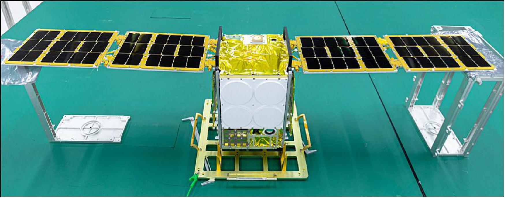
Launch : On 6 November 2020 at 03:20 UTC, Spacety’s 20th satellite,Beihangkongshi-1, carrying the world’s first iodine electric propulsion system on board, was successfully launched into space on a CZ-6 Long March 6 rocket from Taiyuan, in China. Beihangkongshi-1 is the first of the 12U satellite type developed and launched by Spacety. This advanced satellite platform has strong capabilities to support a number of different payloads of high-power consumption and long duty cycle with a patented thermal radiator and an advanced power subsystem. 9)
Mission status of HISEA-1
• May 25, 2021: As small satellites and constellations develop rapidly, the new era of Synthetic Aperture Radar (SAR) satellites evolves. Using a low-cost and high-performance CubeSat and small satellite constellation, faster, more frequent, and more flexible data could be acquired. Using microwaves instead of light waves, the SAR signal is able to penetrate cloud and work at nighttime. The technology of pulse compression and synthetic aperture significantly improve the resolution of SAR images. As a result, two-dimensional (2D), all-weather, and all-day high-precision images could be obtained. Moreover, the C-band has been used comprehensively in ocean remote sensing, due to its phase that is convenient for ocean observations. There are many C-band sensors for ocean observation, such as Gaofen-3, Sentinel-1, and RADARSAT-1/2, which can observe sea surface winds, sea ice, and ocean waves. 10)
- With a mass of 185 kg, HISEA-1 can provide high-quality SAR remote-sensed images whose finest spatial resolution and maximum observation width reach 1 m and 100 km, respectively.
- First, the working orbit of HISEA-1 is a sun-synchronous circular orbit with a height of 512 km and an inclination of about 97°, and the mean local solar time is 12:00 (UTC +8:00). The shooting position can also be adjusted flexibly according to the mission; the global visiting rate may be up to 78.2% for three days, 95.5% for six days, and 99.78% for ten days. As an example, it observed 8 times within one month based on the simulation results. The attitude of the platform could also be adjusted accordingly, with the attitude control accuracy being 0.03º and the attitude stability being 0.002º/s. As C-band SAR, the center frequency of HISEA-1 is 5.4 GHz, and the phased-array antenna has a size of 4.0 m x 0.64 m (azimuth x range).
- Second, the payload of HISEA-1 has three imaging modes: striping, spotlight, and scanning modes (Table 2). The incident angle is from 20° to 35° and the polarization is single VV (vertical transmit and vertical receive) polarization, which is vertical transmission and vertical reception. The spatial resolution and observation width are 3 m and 20 km respectively in striping mode, while the spatial resolution can reach as high as 1 m (azimuth) in spotlight mode. The spatial resolution and observation width of scanning mode are 10 m and 50 km, or in wide mode, 20 m and 100 km. As a comparison, Gaofen-3 SAR satellite has 12 image modes and more polarizations by virtue of the larger size (2750 kg to 180 kg), while at a cost of much higher power (15 kW to 2.5 kW). The small size and low power consumption largely lower the cost of each satellite, making it more suitable for a satellite constellation project, which is being planning and is just starting with HISEA-1.
Mode | Incident angle (º) | Polarization | Resolution (m) | Width (km) |
Striping | 20-35 | VV | 3 | 20 |
Spotlight | 20-35 | VV | up to 1 (azimuth) | 5 x 5 |
Scanning | 20-35 | VV | 10 | 50 |
Scanning (wide) | 20-35 | VV | 20 | 100 |
- The parameters of the platform and payload preliminarily exhibit the observation ability of HISEA-1 in terms of hardware. The first batch of high-definition (HD) images was received in the first week. External calibrations were made based on 13 Zhongwei Remote Sensing Satellite Calibration Field images (Ningxia, China); the geometric positioning, radiation accuracy and image quality of HISEA-1 were validated. The system sensitivity was tested through ten Amazon rainforest images. According to in-orbit tests, the peak-to-sidelobe ratio (PRLR) is less than 27 dB, the integrated sidelobe ratio (ISLR) is less than -13 dB, the azimuth ambiguity-to-signal ratio (AASR) is less than -20 dB, and the range-ambiguity-to-signal ratio (RASR) is less than -20 dB, while the Noise Equal Sigma Zero (NEσο) is less than -22 dB and the absolute radiometric accuracy is 2.0 dB (3σ); all above satisfy the design requirements.
- At this stage, the HISEA-1 satellite is still in the commissioning phase and the image processing plugin is also developing. When in the operation phase, a plugin based on SAR remote-sensing software, such as SNAP and ENVI-SARscape, will be provided. We are also developing our dataset system with official and detailed instructions of data availability; as a commercial satellite, we will also release some free SAR images to the public.
- Based on the first batch of SAR images, we further analyzed and confirmed the powerful functions of these obtained SAR images. The results showed considerable information and landcover, including cities, mountains, farmlands, forests, rivers, lakes, glaciers, and coasts. Some typical data were initially analyzed in the next section.
Typical Data and Preliminary Results
Sea ice
- The sea ice image of the Bohai Sea in China was obtained from the striping imaging mode (Figure 4a). The shape and area of sea ice could be identified clearly. Considering some subsets of this image, the sea ice in different states could be observed. The backscatter is determined by many factors, including the dielectric properties of the constituents, the volume fraction of each constituent, the geometry (shape, size, and orientation) of brine pockets in ice, the surface conditions, as well as the property of snow cover, which makes the sea ice show bright and dark values in the SAR images.
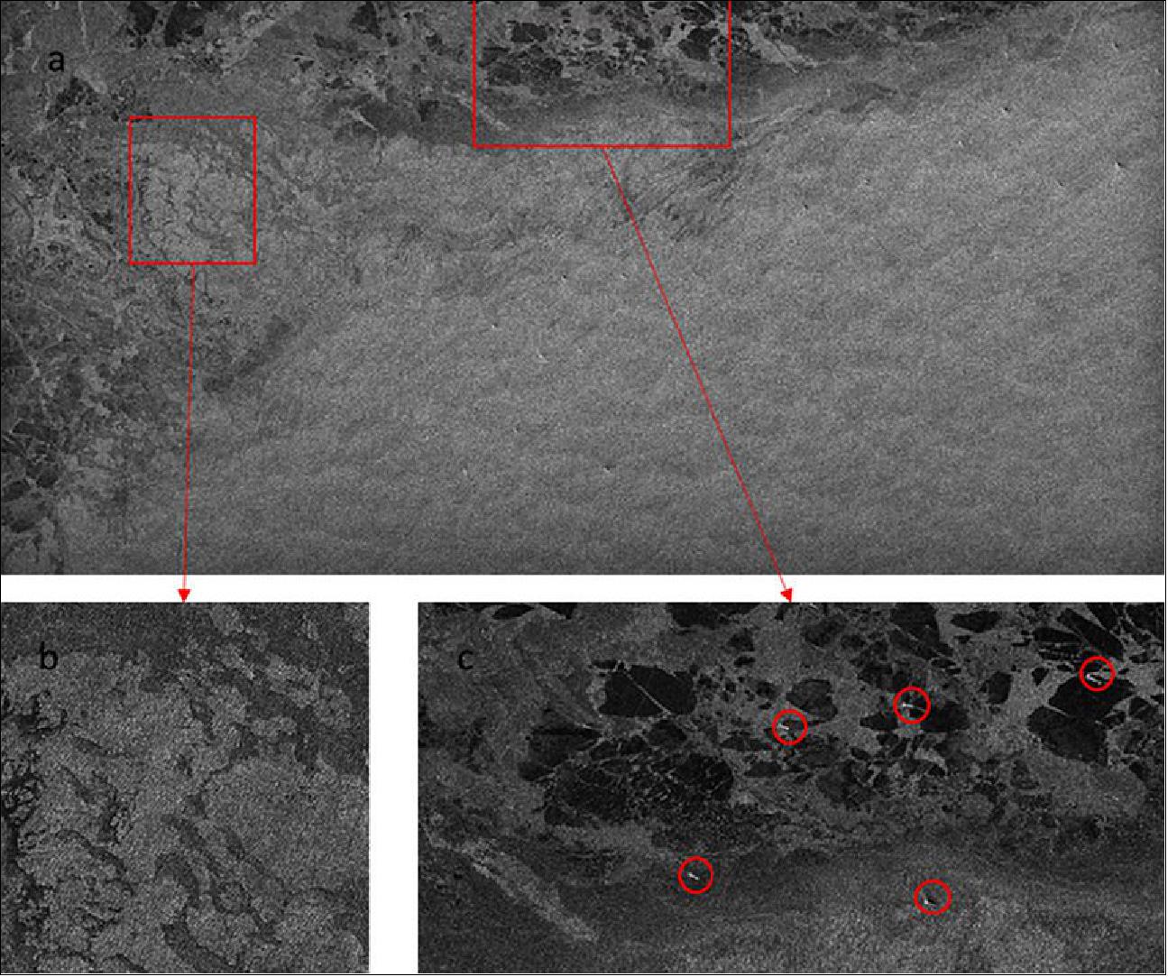
- In Figure 4b, the bright area shows the distribution of the sea ice. This sea ice was rougher due to snowfall, and the edge of sea ice appears darker. The small striped bright pixels marked by red circles in Figure 4b indicate the ships trapped in the sea ice. The sea ice in Figure 4c appears darker because the ice was smoother and younger and contained some leads. The leads were narrow irregular cracks consisting of thinner ice or open water, which are useful for the guidance of icebreaker routes.
- Some interesting phenomena are also reflected in Figure 4b. There were a series of stripes extending from the sea surface to the sea ice. Those stripes that appear in the sea ice should be further investigated.
Ocean Wind, Wave and Rip Current
- The image of North America is shown in Figure 5a. Various landcover, including buildings, farmlands, highways, rivers, and lakes, could be identified. At the same time, striped information is observed on the sea, which contains wind and wave information. Using the LG-mod , the wind direction was calculated, which contained 180° blur. Figure 5c shows the SAR image spectra in the area marked by a red rectangle in Figure 5a. There is also a 180° blur, and the wind direction is similar to that in Figure 5d.
Based on the SAR image spectra, wave length and wave direction of the ocean wave could be obtained, for which the estimation of ocean wave spectra is a necessary prerequisite due to the nonlinear SAR-wave relation. There are several methods for ocean wave spectra inversion, including the Max-Planck Institute (MPI) method, the semi-parametric retrieval algorithm (SPRA), the parameterized first-guess spectrum method (PFSM), and the partition rescaling and shift algorithm (PARSA). In addition, the ocean wave parameters such as significant wave height, average wave period, and wave direction could also be estimated by the methods using the empirical relationship between wave parameters and SAR images, such as CWAVE, convolutional neural network (CNN), and some empirical methods using azimuth cut-off, peak wavelength, and normalized variance to retrieve wave parameters. These results suggest that HISEA-1 could observe winds and waves on sea surfaces. However, since the image was acquired under the commissioning stage, the image has not yet been calibrated. Therefore, the further works about ocean wave inversion would be done by the method mentioned above after testing step.
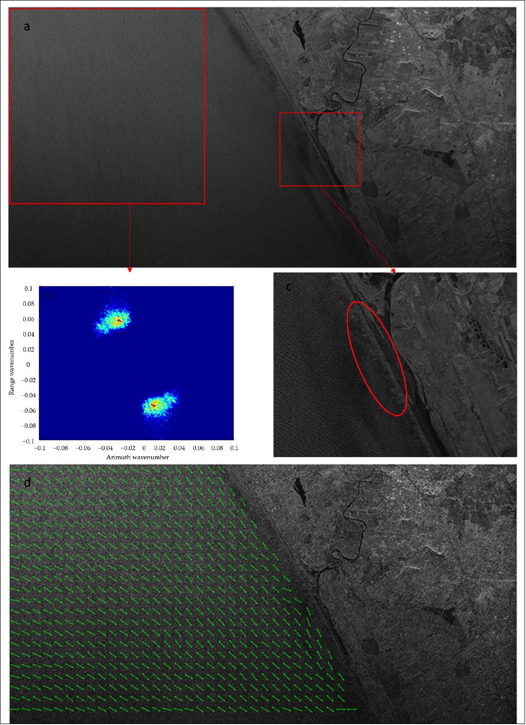
- There are some other interesting phenomena in the coastal area. Some signatures of rip currents were identified in the central enlarged area along the coast in the SAR image, as shown in Figure 5c. Bright elongated cells extending offshore from the coast are inferred to be the rip currents. In addition, there are some irregular bright bands in the sand bar, which could be further analyzed by geologists.
3D Features of High Rise
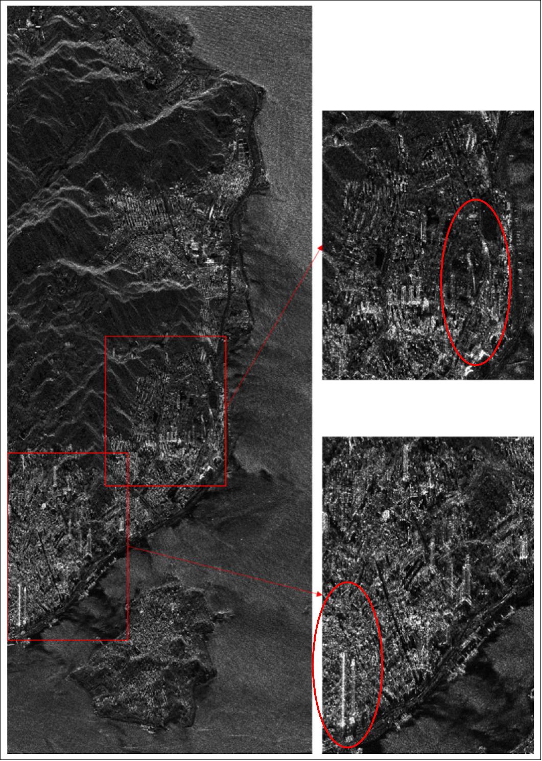
- The area in the red rectangle on the right of Figure 6 is the Siming Campus of Xiamen University. Buildings, lakes, and playgrounds are also shown in the image. Twin towers are observed at the lower-right corner of the right rectangle. The 3D features of some high-rises were shown in the red ovals, in which the bottom is dark and top is bright. Based on the phase information, the quantitative geometric features could be obtained further.
Dark Spots in Image of Kerch Strait
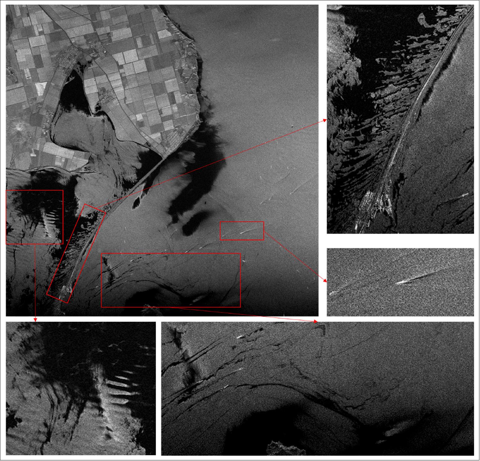
- Kerch Strait is located in the Black Sea. The surface salinity of the Black Sea is low because of the freshwater injection from rivers and low-salinity water injection from the surface of the Mediterranean Sea. However, high-salinity water flows deep into the Black Sea from the Mediterranean Sea. Therefore, there is nearly no interaction between deep and shallow waters. The Azov Sea is the shallowest in the world. Kerch Strait is an important waterway between the Black Sea and Azov Sea.
- Figure 7 shows the striping-mode SAR image of the Kerch Strait. Different cultivated lands appeared as regular squares. The Kerch Strait Bridge spans the strait, and many ships and their wakes are shown in the image. The dark spots in the sea may be oil slicks, upwelling, rain cells, or low-wind-speed areas. The oil film also makes it convenient to study some marine phenomena such as vortexes. Note that the dark spots in Figure 7 were located in the coastal area, so the spots show the polluted domestic water discharged into the ocean. The shape features of dark spots also reveal the current direction. As a result, some features of the air-sea interface phenomena in those dark spots areas could be more easily observed by SAR. The strips of the dark spot at the lower-left corner of the image were the wind streaks. The current under the Kerch Strait Bridge appeared as regular strips, and some vortex structures were also found at the bottom of the image.
Coastal Observation in Delaware Bay
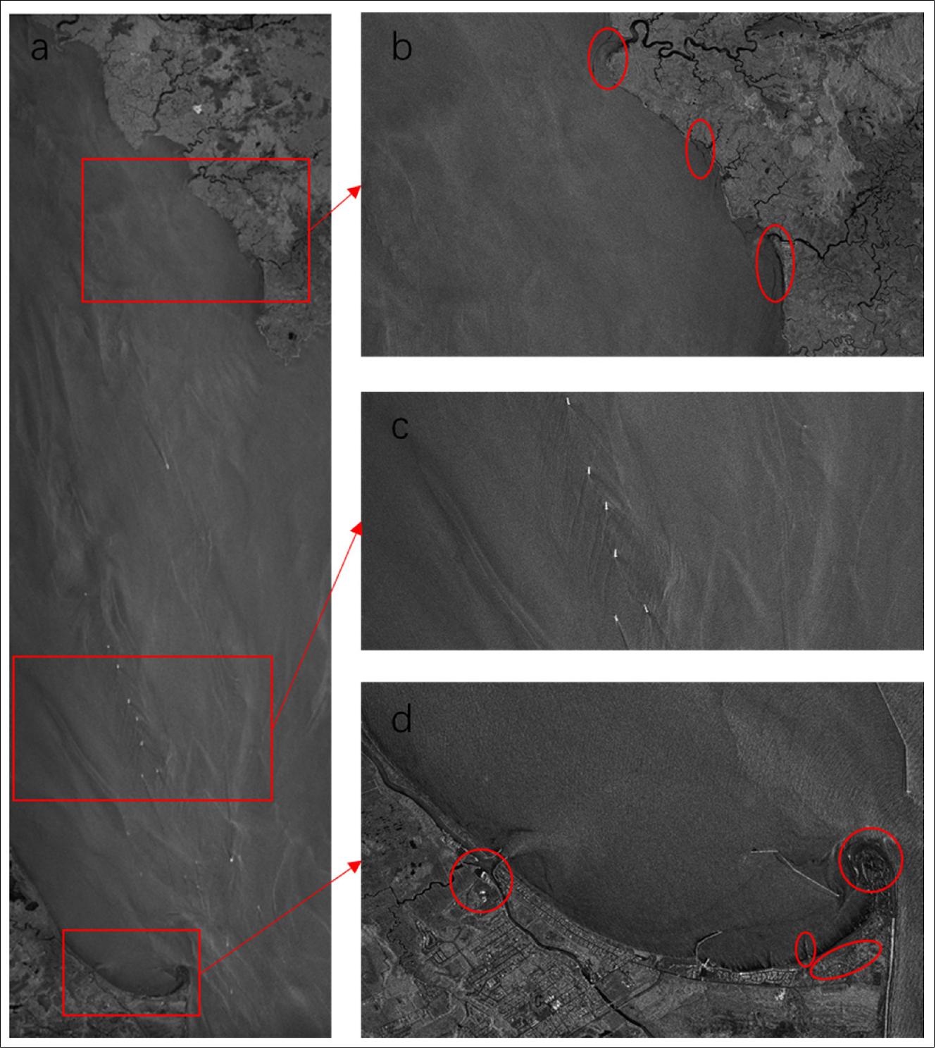
- An image of Delaware Bay is shown in Figure 8, which also contains the information of ocean and coastal observations. Figure 8a is the whole image, in which the stripe information of wind and wave, rivers, and ships could be recognized clearly. Wind and wave are important phenomena which could provide reference for human activities, and retrieve underwater terrain. The images in the red rectangles show more specific details. In Figure 8b, the freshwater rivers are shown as a dark color because the salinity of freshwater is lower than seawater. HISEA-1 could also be used to retrieve the areas with terrestrial freshwater bodies, and the shape of freshwater plumes could be found in the coastal estuaries which are marked with red circles in Figure 8b. In Figure 8c, the bright spots are the sailing ships whose wakes are clearly visible. The ship identification and the ship wakes play important roles in maritime and navigation management. In Figure 8d, several strip-shaped buildings in the sea could be recognized clearly, which are embankments or piers. The red circles and ovals mark the area of University of Delaware Lewes campus, fishing pier Cape Henloppen, Cape Henlopen State Park and University of Delaware Air Sea Interaction Lab, and Cape Henlopen, shown in the order from left to right. In addition, some dark spots appear in the coastal region, which represent the discharge of sewage.
In summary, as the first C-band SAR ocean remote-sensing small satellite, HISEA-1 can obtain images with a spatial resolution of up to 1 m and a large imaging width of 100 km. The first batch of images from HISEA-1 provided considerable information about the land and seas. Images of land could identify different landcover, including buildings, arable lands, highways, rivers, and lakes. It could also provide 3D features of high rises. On the sea, sea ice, some vortex phenomena, oil film, rip currents, etc., could be identified in the images. Some wind and wave parameters could also be retrieved from the SAR images of the ocean.
- This paper has confirmed the great potential of HISEA-1 in ocean and coastal observations. Given the relatively low weight and cost, it is more convenient to construct the satellite constellation with more small satellites such as this, which is what we are planning and will be carried out in the foreseeable future. However, HISEA-1 is still in the commissioning stage and the calibration has not yet been finally finished; more relevant analysis and products will be generated as the calibration and track data are completed.
• January 22, 2020: For the first time ever, a telecommunications satellite has used an iodine propellant to change its orbit around Earth. 11)
- The small but potentially disruptive innovation could help to clear the skies of space junk, by enabling tiny satellites to self-destruct cheaply and easily at the end of their missions, by steering themselves into the atmosphere where they would burn up.
- The technology could also be used to boost the mission lifetime of small CubeSats that monitor agricultural crops on Earth or entire mega-constellations of nanosats that provide global internet access, by raising their orbits when they begin to drift towards the planet.
- The technology was developed by ThrustMe, a spin-off company from the École Polytechnique and the French National Centre for Scientific Research (CNRS), and supported by ESA through its program of Advanced Research in Telecommunications Systems (ARTES).
- It uses a novel propellant – iodine – in an electric thruster that controls the satellite’s height above Earth. Iodine is less expensive and uses simpler technologies than traditional propellants.
- Unlike many traditional propellants, iodine is non-toxic and it is solid at room temperature and pressure. This makes it easier and cheaper to handle on Earth.
- When heated, it turns to gas without going through a liquid phase, which makes it ideal for a simple propulsion system. It is also denser than traditional propellants, so it occupies smaller volumes onboard the satellite.
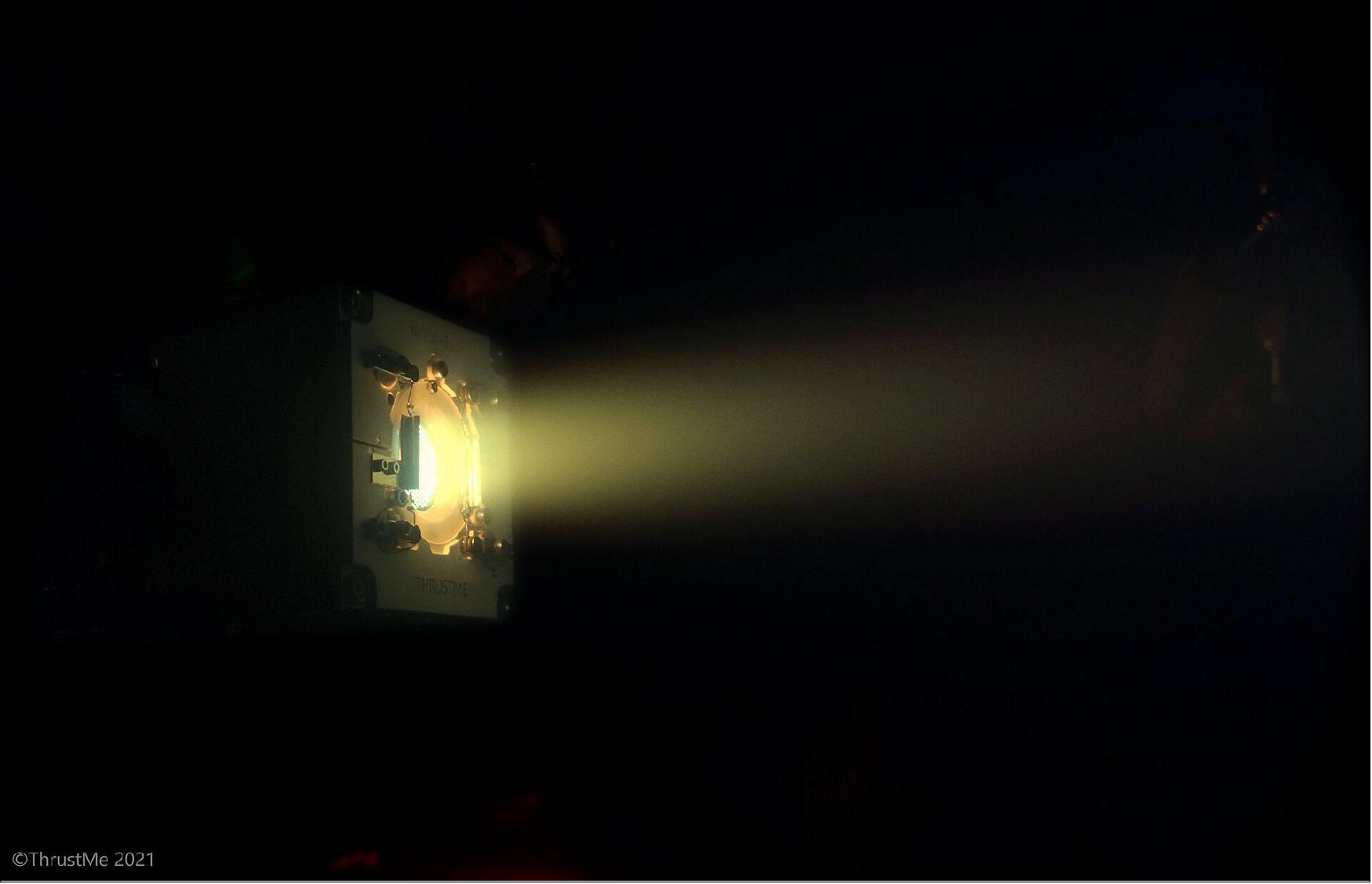
- ThrustMe launched its iodine thruster on a commercial research nanosatellite called SpaceTy Beihangkongshi-1 (12U CubeSat form factor) that went into space in November 2020. It was test fired earlier this month before being used to change the orbit of the satellite.
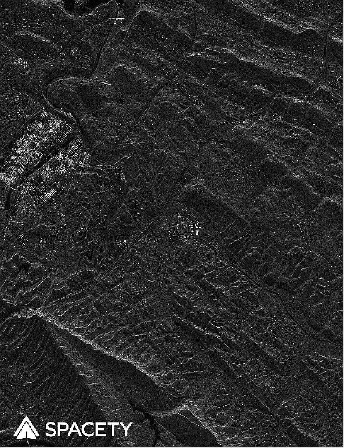
• January 4, 2021: Chinese startup Spacety released the first images from HISEA-1, a C-band Synthetic Aperture Radar (SAR) satellite, launched Dec. 22 on China’s new Long March 8 (LZ-8) medium-lift rocket from Wenchang, China. After a few days of satellite commissioning and verification, at 23:59 PM on December 25, 2020, the echo signals of radar pulses were successfully received for imaging. On December 27, the first batch of SAR images were acquired. 12)
- These are the SAR images generated by the world’s first commercial C-band SAR minisatellite. The images have high resolution and good quality, comparable to those from a large SAR satellite such as Canada’s RADARSAT-2 or ESA’s Sentinel-1, which is more than 12 times heavier than Hisea-1. The images were produced in strip mode with a 3 m resolution. The SAR imaging areas covered include Asia, North America, South America, Europe and Antarctica, with typical landforms of cities, mountains, fields, forests, rivers, lakes, glaciers and coasts. These images demonstrate that Hisea-1 works excellently in space. More testing and calibration will be done before SAR image data services will be provided to users.
Although further images are provided in Ref. 12), they will not be provided since their description (caption) is missing.
Payload
On board of the Beihangkongshi-1 and HISEA-1 minisatellites is ThrustMe’s Iodine Electric Propulsion system, providing each satellite with crucial orbit maintenance, collision avoidance and de-orbiting at the end of its three year expected lifetime, thus ensuring an economical solution for the environmental sustainability of satellite constellations and the space industry. Spacety is very conscious of space sustainability issues, and already has active de-orbiting devices on its satellites, including these two just launched (Ref. 6).
Iodine Electric Propulsion System
Background: The French company ThrustMe emerged from EPFL (Ecole Polytechnique Federale de Lausanne) Switzerland and the CNRS where our founders – Dr Ane Aanesland and Dr Dmytro Rafalskyi - developed their expertise in plasma physics and electric propulsion. Before the creation of the company, they published a total of 75 peer reviewed scientific papers and gained a solid international reputation as experts and out-of-the-box innovators. 13)
In 2014, it became clear for Ane and Dmytro that constellations of miniaturized satellites would be the next big thing – and that these new satellites would need adequate propulsion systems not yet available to them, for the new space industry to fully flourish. Propulsion would allow advanced maneuvers in space and limit debris creation – a sine-qua-non for closing the new business cases of constellations and for assuring a sustainable space environment.
Ane and Dmytro started focusing their research towards miniaturization of electric propulsion, with the idea to solve problems on at system level, rather than focusing on one brick alone – the thruster.
Together with their research colleagues at the Laboratory of Plasma Physics, they studied alternative propellants for plasma-based thrusters and new methods for accelerating ions and electrons to generate thrust. They revisited the fundamentals of space propulsion and got inspirations from many other fields of research, such as physics and methods used in deep-trench-etching of silicon wafers. In 2014 and 2015, Dmytro and Ane filed several patents – maybe the first sign of the entrepreneurial seed being planted in them.
In 2016, our founders decided to change their focus from research to developing prototypes, and they started looking into business cases and business models. With funding and support from SATT Paris-Saclay , our first engineers were recruited, we reached proof-of-concepts that paved the way for our NPT30 propulsion systems small enough to fit in a CubeSat yet performant enough to allow advanced orbital maneuvers.
ThrustMe was incorporated in early 2017. We raised more than 2 million euros of public and private capital in just a few months, we negotiated an exclusive world-wide license to exploit the patents our founders filed while doing their research, and by the end of 2017, we were a top-notch team of 10 complementary people.
Today, ThrustMe has established itself as one of the serious and competent new space actors at an international level. Our passion for space engineering, new technologies and first-principal thinking as driven us – and still does – to create breakthrough products for both space and Earth applications.
• November 6, 2020: French propulsion startup ThrustMe is preparing to conduct an in-orbit demonstration of an iodine electric propulsion system on a 12U Spacety CubeSat (Beihangkongshi-1) launched Nov. 6 at 10:19 Eastern time on a Chinese Long March 6 rocket. 14)
- “It is a historic launch because it’s the first iodine electric propulsion systems that will be tested in space,” ThrustMe CEO Ane Aanesland told SpaceNews.
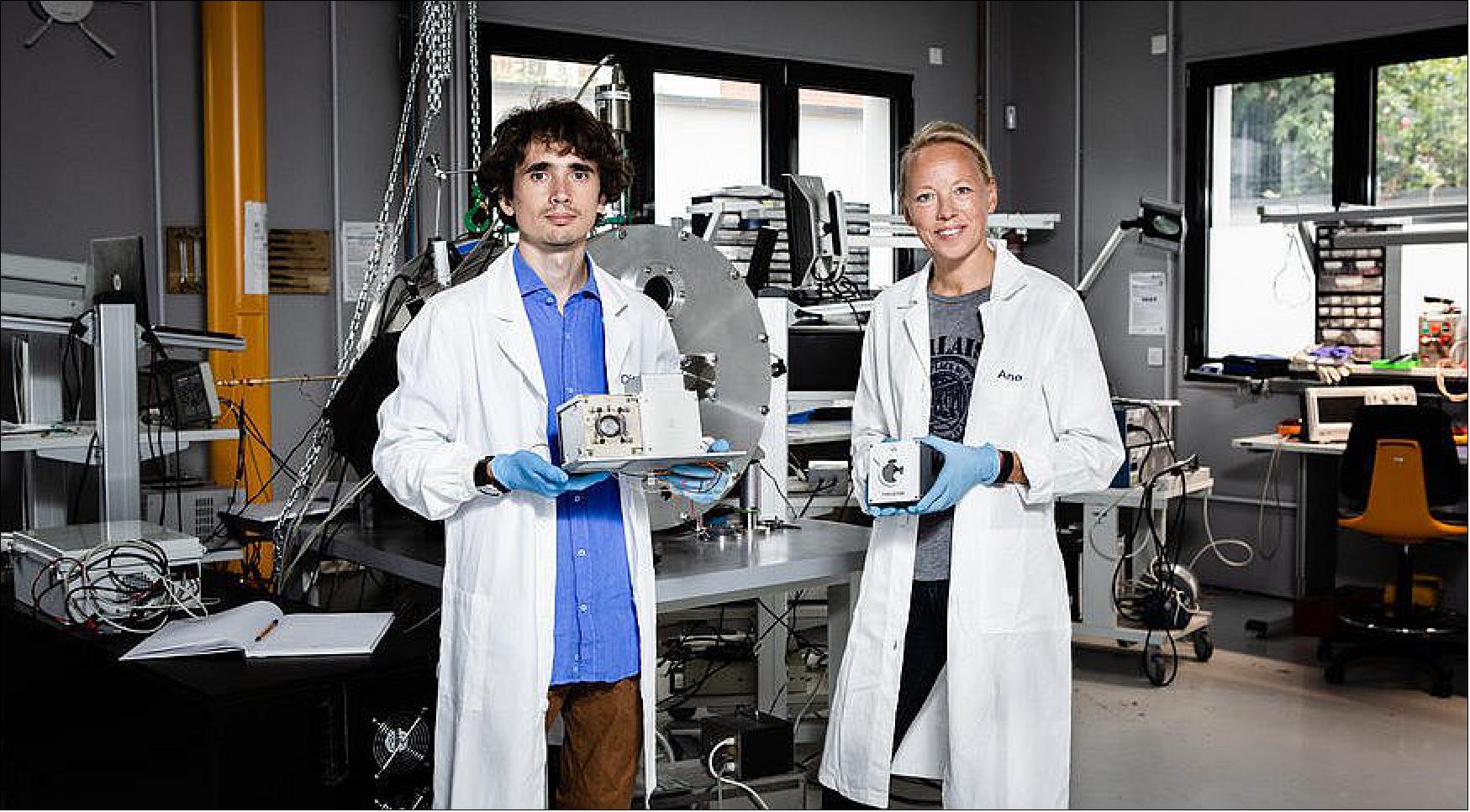
- In addition to ThrustMe’s propulsion, Spacety’s first 12U CubeSat houses a laser communications module and autonomous airplane tracking technology, James Zheng, Spacety Luxembourg CEO, told SpaceNews by email.
- Spacety created a new bus for the Beihangkongshi-1 CubeSat with batteries, a thermal radiator and a solar panel “to support payloads with high power consumption and duty cycle,” Zheng said.
- Beihangkongshi-1 is designed to demonstrate key technologies for multi-beam and multi-channel Automatic Dependent Surveillance-Broadcast to provide continuous global aircraft tracking, communication and intervention for future air traffic control systems, Zheng said.
- “Last year, we tested critical technologies for iodine storage, delivery, and sublimation, on Spacety’s Xiaoxiang 1-08 satellite as part of an in-orbit demonstration of our I2T5 iodine cold gas thruster,” Dmytro Rafalskyi, ThrustMe chief technology officer, said in a statement. “This time, we will test the full capabilities of our NPT30-I2 electric propulsion system and carry out a number of advanced orbital maneuvers.”
- In 2019, ThrustMe tested a cold gas thruster based on the iodine propellant storage subsystem of its electric thruster on a Spacety satellite (23 November 2019).
- In upcoming tests, ThrustMe plans to demonstrate a far more complex propulsion system that pairs the iodine propellant storage with a gridded ion thruster.
- The goal, Aanesland said, is to demonstrate “electric propulsion with high delta-v (ΔV) operations,” meaning the thruster will produce a significant change in the satellite’s velocity.
- The European Space Agency provided ThrustMe with funding for the upcoming in-flight demonstration. It was ThrustMe’s first ESA contract.
- ESA supported development of ThrustMe’s engineering and qualification models as well as flight hardware through its Advanced Research in Telecommunications Systems Competitiveness & Growth program.
1) ”Spacety SAR Constellation,” Spacety, 2021, URL: https://en.spacety.com/index.php/sar-constellation/
2) ”Spacety announces a new space launch,” Spacety, 22 December 2020, URL: https://en.spacety.com/index.php/2020/12/22/spacety-announces-a-new-space-launch/
3) Andrew Jones, ”Spacety Has Big Plans for Small Satellites,” IEEE Spectrum, 19 February 2020, URL: https://spectrum.ieee.org/tech-talk/aerospace/satellites/spacety-startup-plans-news-china-satellites
4) Andrew Jones, ”Private Space Launch Firms in China Race to Orbit,” IEEE Spectrum, 26 April 2019, URL: https://spectrum.ieee.org/aerospace/space-flight/private-space-launch-firms-in-china-race-to-orbit
5) ”UN gives thumbs up to performance of Satellite HISEA-1 made in Hefei,” Foreign Affairs Office, 29 January 2021, URL: https://ahfao.ah.gov.cn/English/News/119984441.html
6) ”Spacety boosts the satellite industry by launching the world’s first C-band commercial Smallsat SAR together with a CubeSat,” Spacety, Press Release, 22 December 2020, URL: https://en.spacety.com
/wp-content/uploads/2020/12/Spacety_PRESS-RELEASE-20201220-SARNPT30-v3-7.pdf
7) Stephen Clark, ”China’s Long March 8 rocket successful in debut launch,” Spaceflight Now, 26 December 2020, URL: https://spaceflightnow.com/2020/12/26/chinas-long-march-8-rocket-successful-in-debut-launch/
8) Andrew Jones, ”China launches first Long March 8 from Wenchang spaceport,” SpaceNews, 22 December 2020, URL: https://spacenews.com/china-launches-first-long-march-8-from-wenchang-spaceport/
9) ”Successfully launched satellite carrying the world’s first iodine electric propulsion system,” Spacety News, 6 November 2020, URL: https://en.spacety.com/
index.php/2020/11/06/released-on-november-6th-2020/
10) Sihan Xue, Xupu Geng, Lingsheng Meng, Ting Xie, Lei Huang and Xiao-Hai Yan, ”Hisea-1: The First C-Band SAR Miniaturized Satellite for Ocean and Coastal Observation,” Remote Sensing, Published: 25 May 2021, https://doi.org/10.3390/rs13112076
11) ”Iodine thruster could slow space junk accumulation,” ESA Applications, 22 January 2021, URL: https://www.esa.int/Applications/Telecommunications_Integrated_Applications
/Iodine_thruster_could_slow_space_junk_accumulation
12) ”Imagery from Hisea-1 SAR Satellite Unveiled,” Spacety, 30 December 2020, URL: https://en.spacety.com/index.php/2021/01/04/
imagery-from-worlds-first-c-band-commercial-smallsat-sar-hisea-1-satellite-unveiled/
13) ”ThrustMe,” URL: https://www.thrustme.fr/our-story
14) Debra Werner, ”Spacety launches satellite to test ThrustMe iodine electric propulsion and constellation technologies,” SpaceNews, 6 November 2020, URL: https://spacenews.com/thrustme-2020-demonstration/
The information compiled and edited in this article was provided by Herbert J. Kramer from his documentation of: ”Observation of the Earth and Its Environment: Survey of Missions and Sensors” (Springer Verlag) as well as many other sources after the publication of the 4th edition in 2002. - Comments and corrections to this article are always welcome for further updates (herb.kramer@gmx.net).
Spacecraft Launch Mission Status Payload References Back to top