SPORT (Scintillation Prediction Observations Research Task)
EO
Atmosphere
NASA
Magnetic field
SPORT (Scintillation Prediction Observations Research Task) is an international partnership between NASA (National Aeronautics and Space Administration), the Brazilian National Institute for Space Research (INPE), and the Technical Aeronautics Institute under the Brazilian Air Force Command Department (DCTA/ITA), with a purpose to further an understanding of the preconditions leading to equatorial plasma bubbles. The satellite is expected to provide data for approximately 2.5 years following launch from the International Space Station (ISS).
Quick facts
Overview
| Mission type | EO |
| Agency | NASA, INPE |
| Mission status | Operational (nominal) |
| Launch date | 26 Nov 2022 |
| Measurement domain | Atmosphere, Gravity and Magnetic Fields |
| Measurement category | Gravity, Magnetic and Geodynamic measurements |
| Measurement detailed | Magnetic field (scalar), Magnetic field (vector), Atmospheric stability index, Electron density profile, Ion Density, Drift Velocity, and Temperature, Electric Field (vector) |
| Instruments | Electromagnetic Tracker, Magnetometer |
| Instrument type | Magnetic field |
Summary
Mission Capabilities
SPORT carries six primary instruments. The Ion Velocity Meter (IVM) will measure the energy distribution and direction of ion plasma along the satellite’s path. The Compact Total Electron Content Sensory (CTECS) is to obtain electron density profiles at low latitudes and detect the presence of scintillation. Measuring electric fields will be an Electric Field Probe (EFP), that will identify disturbed regions of the ionosphere. Also present will be a Langmuir Probe, to measure plasma density, neon, nickel, temperature, floating potential, and space potential. A Swept Impedance Probe (SIP) is intended to determine absolute electron density by monitoring the changing impedance of a short cylindrical probe excited over a radio frequency range. Finally, a fluxgate magnetometer is to provide high-resolution measurements of the ambient magnetic field. This should be of sufficient sensitivity to potentially observe perturbations due to pressure gradients, diamagnetic cavities, or Alfvénic waves.
Performance Specifications
The IVM supports a field of view of 30⁰, while the CTECS supports 160⁰. The other four primary instruments each support a field of view of 180⁰. Peak power is 0.3 W for the IVM, 1.5 W for the CTECS, 0.15 W for the EFP and Langmuir Probe, 0.4 W for the SIP, and 0.45 W for the Magnetometer. In terms of data collection, the IVM and Langmuir Probe attain data rates of 2.0 kbps, the CTECS and SIP do so at 1.0 kbps, though the CTECS ups this rate to 15 kbps at night, the EFP collects data at 1.4 kbps, and the Magnetometer collects data at 2.8kbps.
SPORT will be launched from the ISS at an approximately 400 km altitude to follow a near circular orbit at 51.6⁰. After 2.5 years, its orbit is expected to reduce to an altitude of approximately 350 km.
Space and Hardware Components
Various booms are deployed to place sensors in undisturbed plasma and to remove them from various noise sources present at the spacecraft bus. Ridged booms lie along the bus and are spring-hinged, automatically locking into place once deployed. The EFP is held on a set of 0.3 m booms deployed horizontally. Two additional probes are deployed: a 0.3 m probe is deployed anti-nadir for the SIP and another is deployed at nadir with the Langmuir Probe and magnetometer attached. Located on the nadir face of the craft is an X-band antenna for offloading data at high rates.
SPORT (Scintillation Prediction Observations Research Task)
Overview Launch Mission Status Sensor Complement Ground Segment References
Overview
SPORT is a 6U CubeSat mission to address the compelling but difficult problem of understanding the preconditions leading to equatorial plasma bubbles. Much has been learned about the conditions, or state, of the ionosphere that typically precede equatorial plasma bubbles. Signatures in both the density profiles and the plasma drifts are related with some confidence to the resulting formation of plasma bubbles several hours later in the evening. A significant amount of this scientific discovery has come from the Jicamarca Radio Observatory, a single site in Peru, within a single longitude sector. What is needed now is a systematic study of the state of the pre-bubble conditions at all longitude sectors. 1)
The SPORT project is an international partnership between NASA, the Brazilian National Institute for Space Research (INPE), and the Technical Aeronautics Institute under the Brazilian Air Force Command Department (DCTA/ITA). It has been encouraged by U.S. Southern Command (SOUTHCOM) to foster increased cooperation and ties between academics, civilian space programs and the militaries. SPORT has proven leadership in key positions, clarity in roles and responsibilities, and clean simple interfaces between institutions.
NASA is overseeing the flight instruments and the launch to orbit; U.S. partner institutions are providing flight-proven instruments; and the Brazilian partners are contributing the spacecraft, observatory integration and test, ground observation networks, and mission operations and data management. The science data will be distributed from and archived at the INPE Brazilian Monitoring and Study of Space Weather (EMBRACE) regional space-weather forecasting center, and mirrored at the NASA/GSFC (Goddard Space Flight Center) SPDF ( Space Physics Data Facility).
The U.S. and Brazil are teaming up to study scintillation in the ionosphere, a phenomenon that affects radio signals, disrupting communications and GPS navigation. The SPORT project is an effort to study the formation and evolution of equatorial plasma bubbles which may, in turn, cause scintillation. 2)
The SPORT mission partners are:
• NASA/MSFC/GSFC (Marshall and Goddard Flight Centers) with James Spann of MSFC as PI (Principal Investigator).
• INPE, the Brazilian National Institute for Space Research
• Technical Aeronautics Institute under the Brazilian Air Force Command Department (DCTA/ITA)
• The Aerospace Corporation, El Segundo, CA
• UTD (University of Texas at Dallas)
• UAH (University of Alabama in Huntsville)
• USU (Utah State University), Logan, Utah.
Brazil will build and operate the 6U CubeSat as well as maintain the ground observation network of radars, imagers, and scintillation monitors. On the U.S. side, NASA is coordinating the launch and the instruments that will go on the CubeSat, including Aerospace's sensor and five other instruments provided by NASA and university partners. Both Brazil and the U.S. will analyze the data and collaborate on individual studies. 3)
Mission Objectives and Methodology
Low latitude ionospheric structures including equatorial plasma bubbles have been observed for decades. They are the primary source of radar reflections in the equatorial F-region ionosphere and cause strong scintillations on radio signals passing through them. The relationships between background ionospheric conditions and the irregularity regions, which may influence their growth to high altitudes are still poorly understood. SPORT will address two specific questions about these phenomena:
1) What is the state of the ionosphere that gives rise to the growth of plasma bubbles that extend into and above the F-peak at different longitudes?
2) How are plasma irregularities at satellite altitudes related to the radio scintillations observed passing through these regions?
The SPORT mission will answer these science questions by:
a) developing and launching a CubeSat observatory to measure key phenomena,
b) leveraging data from existing Brazilian ground observation networks,
c) collecting, analyzing, and distributing resultant geophysical data and analysis tools, and
d) integrating relevant data analysis into scientific presentations and publications addressing the posed science questions.
In situ and radio occultation sensors on a CubeSat will be augmented by ground instruments in the Brazilian sector. SPORT will be launched into a mid-inclination nearly circular orbit.
Superimposed on airglow images in Figure 1 in black is the ground trace of the satellite orbit. Plasma drifts and density will be observed in situ and each satellite pass will give a latitude profile of the plasma density across the anomaly peaks in a longitude range of <30°. A GPS (Global Position Satellite) radio occultation receiver will be used to observe both plasma density profiles and scintillation occurrences remote from the spacecraft. The tangent point distance for these GPS occultations often occurs over previous or upcoming ground traces of this spacecraft's orbit. This geometry allows SPORT to characterize the ionospheric state (drifts, density, etc.) of a longitude sector and then observe the same region one orbit later to determine if bubbles or irregularities have formed and/or evolved. Ground-based observations of both, the state of the ionosphere and scintillations of RF signals, will complete the dataset required for this study. When SPORT is over the Brazilian sector, satellite techniques currently being developed will be correlated against ground-based observations. The project will compare the ground-based observations of scintillation on RF signals with satellite-based measurements of density structures to address the parts of our scientific study focused on scintillation mechanisms.
Scientific Objectives and Requirements
The science objectives of SPORT are consistent with the strategic goals of the NASA Heliophysics Division and the NSF (National Science Foundation) Geospace Section of the Atmospheric and Geospace Division. It is fully consistent with the conclusions and recommendations of the National Academy report "Achieving Science with CubeSats". 4)
SPORT addresses outstanding questions on the triggers, predictability, and effects of irregularities in the equatorial ionosphere. SPORT provides balance to NASA's Heliophysics Division's current and future mission portfolio with its focus on the Earth's ionosphere and is synergistic with two upcoming Explorer class missions: GOLD (Global-scale Observations of the Limb and Disk); and ICON (Ionospheric Connection Explorer). GOLD can provide global context to the SPORT observations and ICON can provide regional context on the formation of the equatorial anomalies where irregularities occur. Together SPORT, GOLD and ICON form a powerful probe of the ionosphere.
The SPORT mission is focused on the very compelling but difficult problem of understanding preconditions leading to equatorial plasma irregularities also known as Spread-F or plasma bubbles. The growth and evolution of plasma density structures in the equatorial ionosphere have been studied for many years and information about their general appearance and climatological variations is available. Much of the information is obtained from detailed ground-based observations from the South American continent and from a distributed network of radio scintillation receivers. 5) 6)
Our scientific objectives place requirements for observing plasma drifts, density and the presence of scintillations in specific regions and ways. The objectives flow down to specific instrumentation, sensitivities, and sampling rates. Most important is the observational strategy we have developed to address our science questions.
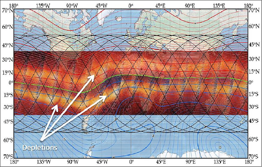
In Figure 1, the UV Airglow images from the TIMED (Thermosphere Ionosphere Mesosphere Energetics and Dynamics) mission clearly show the equatorial anomaly with embedded depletions that have penetrated the F peak. Green, red, and blue traces show the magnetic equator, and positive and negative dip angles. SPORT ground tracks are superimposed in black.
The equatorial anomaly is due to the so-called fountain effect associated with upward plasma drifts. The TIMED satellite shows the equatorial plasma density anomaly as observed by bright bands in 135.6 nm emissions on both sides of the magnetic equator. Superimposed on Figure 1 are the magnetic equator in green, the dip angle in red and blue illustrating the uniqueness of the magnetic geometry in the Brazilian sector. These observations were obtained at the same local times, several hours after local midnight, for each longitude sector. They record bubble formation over the course of a single evening. Large plasma depletions viewed from above can appear as broad backward C-shaped structures across both peaks of the anomaly that are conspicuous due to the absence of ultraviolet emission from electron and O+ recombination. 7) SPORT will make progress on addressing questions of the state of the ionosphere that preceded plasma bubble formation and ultimately help in explaining why bubbles develop and rise to various altitudes at different times in different regions and latitude.
Science Methodologies and Closure on Science Objectives
We will address our first science question with several methodology and observational scenarios. In the first, the state of the ionosphere at a specific longitude and local time is first sampled using the in-situ instruments. On the next orbit, the Earth's rotation subsequently moves that same longitude sector away from the satellite to be sampled remotely using GPS occultation at a local time that is 1 hour and 40 minutes later than previously sampled. In this manner, a description of the plasma density profile and line of sight scintillations at different latitudes in the target longitude region may be compared with the latitude profile of the plasma density, drift and structures observed earlier in time by the satellite.
The second scenario reverses the role of the in-situ and remote occultation measurements. Here a description of the plasma density profile at different latitudes in the target longitude region from radio occultation may be compared with the latitude profile of the plasma density, drift and structures observed later in time by the satellite's in-situ instruments. Again, during the daytime the coupling between plasma dynamics and the plasma density distribution will be examined and across sunset and in the evening hours, the conditions that promote the growth of plasma structures will be revealed.
In the third scenario, the target longitude is located in the South American continent where extensive ground based observational capability is in place. In this case, the time development of the ionosphere will be well documented. It will then be directly compared with the in-situ latitudinal profiles obtained from the satellite. Further, the appearance of plasma structures will be well documented, whether or not they penetrate to the satellite altitude.
An occultation will provide both a vertical profile of line-of-site TEC (Total Electron Content) and a vertical profile of the S4 index indicating the presence of scintillations. The line-of-site TEC will be used to compute the height of the F-peak and a plasma density profile. Key to achieving the observational strategy is the number of GPS occultations with tangent points at adjacent orbits tracks. Simulations show that over a one-year mission period, at least 39 appropriate occultation events occur in each of 18 longitude sectors for each two-hour local time window. This provides a sufficient number of events to statistically address the first science question in the time period from sunset to midnight.
These data will be augmented with a nearly complete description of the ionospheric state obtained from ground-based measurements in Brazil. Of most significance to SPORT is an array of GPS receivers that provide a description of the equatorial TEC distribution localized in South American longitudes. The EMBRACE center provides TEC maps every 10 minutes.
The second science question will be addressed through measurements of the plasma density and vertical plasma drift with high spatial resolution, allowing characterization of the spatial structures with scale sizes down to 200 m. While the full resolution data will be retained for analysis, for the purposes of ionospheric specification we will characterize the irregularities in terms of the power spectral density and spectral slope in the range from 200 km to 2 km and from 2 km to 200 m.
Work by Stoneback et al. 8) has shown that plasma density irregularities observed at the satellite can be used in conjunction with information on the spectral content of the structure to infer equivalent scintillation intensity for given frequencies. Comparisons with ground-based observations using this technique suggest that such a methodology can be used globally and verified at specific locations. Once verified using available data in the Brazilian sector, the same procedures can be applied at other longitudes to produce a global description of scintillation at different frequencies.
Another prediction approach we are exploring uses the line-of-site S4 observations from a GPS occultation that fall along or near the satellite track. This will allow a comparison between the spectral content of the in situ density observations with the line line-of-site observations of TEC, which has not been reported in the literature.
Technical Approach and Methodology
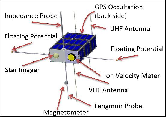
The SPORT 6U CubeSat is illustrated in Figure 2. Booms deploy to place sensors in undisturbed plasma and to remove them from various noise sources present at the spacecraft bus. The ridged booms lie along the spacecraft bus and are spring hinged, locking into place once deployed. One set of 30 cm booms is deployed horizontally as a set of probes for the EFP (Electric Field Probe) that observes waves and the spacecraft floating potential. A 30 cm probe is deployed in the anti-nadir direction for use by the impedance probe and a second boom is deployed nadir with both a Langmuir probe sensor tip and a magnetometer. The GPS patch antenna is mounted on the wake surface of the satellite and a set of turnstile antennas are used for communications with the spacecraft bus. An X-band antenna is located on the nadir face for offloading data at high rates.
The scientific objectives in Table 1 can be achieved with, for example, a launch from the ISS that meets the altitude and inclination requirements and for which launch opportunities are frequent. The spacecraft will be pointed on orbit such that the spacecraft presents a minimum cross-section to minimize drag. The spacecraft will have ballast mass added to extend the life of the spacecraft. An ISS launch provides ~2.5 mission years with the spacecraft starting at 400 km and ending at 350 km during the proposed mission period. The Nanoracks standard ISS deployment allows for 6U spacecraft up to a mass of 16.9 kg, which gives a mission life of more than 5 years. Because of this, there is significant margin to meet the one-year mission requirement of SPORT.
The Scintillation Production Observation Research Task (SPORT) | Instrumentation | Spacecraft | |
Observational approach | Science measurement requirements | Instrument approach | Space systems requirements |
1) What is the state of the ionosphere that gives rise to the growth of plasma bubbles that extent into and above the F-peak at different altitudes? | |||
Observations in the 1700 to 0100 | Plasma Density Profile | GPS Occultation | Satellite Orbit |
2) How are plasma Irregularities at satellite altitudes related to the radio scintillations observed passing through these regions? | |||
Observations in the 2200 to 0200 | E-Field (Earth Reference Field) | E-Field Double Probe |
|
Launch
The Scintillation Prediction Observations Research Task (SPORT) nanosatellite, arrived at the International Space Station on November 27, 2022, as part of SpaceX’s 26th commercial resupply mission for NASA. Both CubeSats deployed from the space station on Dec. 29, 2022, at 8:55 a.m. EST.18)
Orbit: 400-km of altitude and 52-degrees inclination.
Mission Status
• January 3, 2023: SpaceX-26 launched on 11/26/22, carrying the Scintillation Prediction Observations Research Task (SPORT) to the International Space Station (ISS). On 12/29/22, SPORT was successfully deployed into its nominal orbit of 400-km and 52-degrees inclination. The beacon is strong, and it is being received by two SPORT ground stations in Brazil and several Amateur Radio ground stations.
The amateur radio operators have shared the Beacon data with the SPORT Ops and Science Teams, and are all in concurrence that a subset of the Beacon’s radio signal is experiencing ionospheric scintillation, and the data provide quantifiable values of its intensity.
Thus, even before the satellite has been commissioned, the Scintillation Prediction satellite is measuring scintillation. The Beacon scintillation data will be used in conjunction with the scientific scintillation data that will be received after the satellite is commissioned. The antennas have deployed, and all telemetry is nominal.
The next milestone is to detumble the spacecraft and the whole commissioning procedure is expected to take three more weeks. 19)
• December 30, 2022: SPORT deployed from the space station at 8:55 a.m. EST
• November 27, 2022: The Scintillation Prediction Observations Research Task (SPORT), arrived at the International Space Station on November 27, 2022, as part of SpaceX’s 26th commercial resupply mission for NASA.
Sensor Complement
The instrument suite is summarized in Table 2 including the scientific parameters to be sensed and the expected measurement performance of the instruments. This table, together with Table 1, presents the science traceability matrix for SPORT. This table also presents an overview of the requirements for the sensors including pointing, mass, volume and telemetry requirements on the spacecraft bus.
IVM (Ion Velocity Meter). The CubeSat Ion Velocity Meter (cs-IVM), provided by the University of Texas at Dallas (UTD) uses a technique with extensive heritage in space to measure the velocity of the ion component of ionospheric plasma at the sensor location (Figure 2). The IVM is mounted on the spacecraft to view along the velocity vector in the ram direction, and acts as two traditional instruments, a planar RPA (Retarding Potential Analyzer), and a planar IDM (Ion Drift Meter), which measures arrival angle of the thermal plasma with respect to the look direction in two mutually perpendicular planes.
CTECS (Compact Total Electron Content Sensor): SPORT will make use of Aerospace Corporation's CTECS to obtain electron density profiles at low latitudes and to detect the presence of scintillation. CTECS is a GPS occultation sensor consisting of a commercial NovAtel receiver, the OEM628, with modified software and a custom-designed antenna. CTECS has flown on the PSSCT-2 (PicoSatellite Solar Cell Testbed 2) mission in 2011 and on the two-CubeSat SENSE (Space Environment NanoSat Experiment) mission in 2013. CTECS can be commanded to sense slant TEC, scintillations (S4 mode), or both. 10)
EFP (Electric Field Probe): The EFP, provided by USU (Utah State University), is used to measure only one component of both DC and AC electric fields for identifying disturbed regions of the ionosphere. It is an implementation of the double-probe class of in-situ electric field instruments that has been used for decades to observe electric fields in the space environment. 11)The EFP has most recently flown as part of the ASSP (Auroral Spatial Structures Probe) in January 2015, and the DICE (Dynamic Ionosphere CubeSat Experiment) mission. 12)
Langmuir Probe: The Langmuir probe is also provided by USU to measure plasma density, Ne and Ni, as well as temperature, Te, the floating potential, Vf, and the space potential, Vs. The measurements are based on the current-voltage (I-V) response characteristics of a conductor immersed in plasma at a Debye length or greater from surrounding structures. 13)
SIP (Swept Impedance Probe): The SIP will be used to determine the absolute electron density, irrespective of the payload charging, by monitoring the changing impedance of a short cylindrical probe excited over a radio frequency (RF) range. This data will be used to compute Ne, which will be used to understand the state of ionosphere and nature of the density structures observed. Impedance probe techniques have been used for over 30 years to probe electron density in the ionosphere. 14) Three of these probes most recently flew on the NASA ASSP and MTeX (Mesosphere-Lower Thermosphere Turbulence Experiment) missions in January 2015 in auroral conditions.
Magnetometer: A GSFC produced miniature vector fluxgate magnetometer system will provide high-resolution measurements of the ambient magnetic field with sufficient sensitivity to potentially observe perturbations due to pressure gradients, diamagnetic cavities, or Alfvénic waves. The fluxgate magnetometer is deployed on a relatively short boom (~20 cm) to remove it from the majority of the magnetic noise of the spacecraft bus. Two additional magnetometers, a USU magnetoresistive magnetometer located at the base of the boom and a Brazilian Hall current magnetometer in the spacecraft avionics near the wake side of the spacecraft, provide independent observations of the spacecraft magnetic noise, e.g. 15) The GSFC Fluxgate is an in-house research and design effort based on the ST-5 (Space Technology 5) mission magnetometer. 16) It has been deployed on the Dellingr 6U CubeSat, developed at GSFC.
Parameter | IVM | CTECS | EFP | Langmuir Probe | SIP | Magnetometer |
Scientific | Vi:±800 M/s, 20 m/s, | Ne-Profile: 104 to | 0.1 to ±45 mV/m | ΔΝe: 103 to 107 cm3 | Ne: 103 to 107 cm3 | ±56,000 nT, |
Instrument | Vi:±1000 m/s, 15 m/s | Scintillations (S4) |
|
|
|
|
Ground Segment
SPORT will use ground segment elements and operational procedures that already exist in the INPE ground facilities located at Cuiabá (center west), São José dos Campos (southeast), and Santa Maria (south). For scientific data downlink (ERD), we will use two X-band antennas located at Cuiabá. For mission command and monitoring, two TT&C (Telemetry, Tracking and Command) ground stations will be available in São Jose dos Campos and Santa Maria under control of CCS (Satellite Control Center), also located in São José dos Campos. The CCS at INPE headquarters in São José dos Campos will remotely operate very high frequency / ultra-high frequency (VHF/UHF) ground stations using SATCS (SATellite Control System) software system and communication private links CCSDS (Consultative Committee for Space Data Systems) combined.
Data Management: The data center at EMBRACE will receive the CCS Level 0 data and distribute decommutated instrument and engineering data to the instrument teams for data reduction. The reduced instrument data will be sent back to EMBRACE from each instrument team, where it will be processed, archived, and ingested into space weather analysis models and tools. SPORT has a fully open data policy consistent with NASA data policies. The scientific data reduction, dissemination, and storage of SPORT data will be managed at EMBRACE. EMBRACE will be the SPORT mission data distribution center for the science and user communities. The data will be mirrored and also archived in the GSFC SPDF. The science results will be published and presented at relevant conferences.
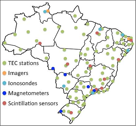
Ground-Based Science Instruments: SPORT will use a distributed ground network to compliment its space-based observations. Figure 3 shows the geographical coverage and type of instrumentation that will be used. Of primary significance is a ground-based GPS receiver network that maps the ionosphere TEC over Brazil and provides near-real time data to EMBRACE. The spatial resolution is 50–500 km depending on receiver density. EMBRACE provides realtime TEC maps every 10 minutes. This network describes the evolution of irregularities and scintillation signals at a specific longitude in the South American sector regardless of the altitude at which irregularities appear. Other ground-based assets such as incoherent scatter radars and all-sky cameras will provide secondary science opportunities.
A review paper by Denardini, et al. [2016]17) provides a complete description of ground networks in the South American sector, including the network that SPORT will use.
References
1) James Spann, Charles Swenson, Otavio Durão, Luis Loures, Rod Heelis, Rebecca Bishop, Guan Le, Mangalathayil Abdu, Linda Krause, Craig "Ghee" Fry, Clezio Denardini, Lidia Shibuya, Joseph Casas, Shelia Nash-Stevenson, Polinaya Muralikrishana, Joaquim Costa, Eric Eberly, Bryan Mesmer, Marcelo Banik de Padua, Cristiano Wrasse, "The Scintillation Prediction Observations Research Task (SPORT): An International Science Mission using a CubeSat," Proceedings of the 31st Annual AIAA/USU Conference on Small Satellites, Logan UT, USA, Aug. 5-10, 2017, paper: SSC17-XIII-03, URL: http://digitalcommons.usu.edu/cgi/viewcontent.cgi?article=3695&context=smallsat
2) James F. Spann, Charles Swenson, Otavio Durão, Luis Loures, Rod Heelis, Rebecca Bishop, Guan Le, Abdu, Linda Krause, Clezio Nardin, Eloi Fonseca, "SPORT - The Scintillation Prediction Observations Research Task," CEDAR-GEM Joint Workshop, Santa Fe, New Mexico, June 19 – 24, 2016, URL: https://ntrs.nasa.gov/archive/nasa/casi.ntrs.nasa.gov/20160000263.pdf
3) "Upper atmospheric mission sports an Aerospace Sensor," The Aerospace Corporation, May 4, 2017, URL: http://www.aerospace.org/news/highlights/upper-atmospheric-mission-sports-an-aerospace-sensor/
4) "Achieving Science with CubeSats -Thinking Inside the Box," The National Academies of Sciences, Engineering, Medicine, The National Academies Press, 2016
5) R. F. Woodman, "Spread F – an old equatorial aeronomy problem finally resolved?," Annales Geophysicae, Vol. 27, pp: 1915–1934, May 4, 2009, URL: https://www.ann-geophys.net/27/1915/2009/angeo-27-1915-2009.pdf
6) Jules Aarons, "The longitudinal morphology of equatorial F-layer irregularities relevant to their occurrence," Space Science Reviews, September 1993, Volume 63, Issue 3–4, pp: 209–243, DOI: https://doi.org/10.1007/BF00750769
7) Hyosub Kil, S.-Y. Su, Larry J. Paxton, Brian C. Wolven, Yongliang Zhang, Daniel Morrison, H. C. Yeh, "Coincident equatorial bubble detection by TIMED/GUVI and ROCSAT-1," Geophysical Research Letters, Volume 31, Issue 3, February 2004, DOI: 10.1029/2003GL018696, URL: http://onlinelibrary.wiley.com/doi/10.1029/2003GL018696/epdf
8) R. A. Stoneback, R. A. Heelis, R. G. Caton, Y.-J. Su, K. M. Groves, "In situ irregularity identification and scintillation estimation using wavelets and CINDI on C/NOFS," Radio Science, Volume 48, Issue 4, July/August 2013,pp: 388–395, DOI: 10.1002/rds.20050, URL: http://onlinelibrary.wiley.com/doi/10.1002/rds.20050/epdf
9) "Joint NASA-Brazil SPORT CubeSat Mission Will Unlock Complex Equatorial Phenomena, Lay Groundwork for Better Space Weather Prediction," NASA, 3 Aug. 2017, http://www.prnewswire.com/news-releases/joint-nasa-brazil-sport-cubesat-mission-will-unlock-complex-equatorial-phenomena-lay-groundwork-for-better-space-weather-prediction-300499506.html
10) Rebecca L. Bishop, David A. Hinkley, Daniel R. Stoffel, David E, Ping, Paul R. Straus, Timothy R. Brubaker, "First Results From the GPS Compact Total Electron Content Sensor (CTECS) on the PSSCT-2 Nanosat," Proceedings of the 26th Annual AIAA/USU Conference on Small Satellites, Logan, Utah, USA, August 13-16, 2012, paper: SSC12-XI-2, URL: http://digitalcommons.usu.edu/cgi/viewcontent.cgi?article=1088&context=smallsat
11) U. Fahleson, "Theory of electric field measurements conducted in the magnetosphere with electric probes," Space Science Reviews, October 1967, Volume 7, Issue 2–3, pp 238–262 , DOI: https://doi.org/10.1007/BF00215600
12) C. S. Fish, C. M. Swenson, G. Crowley, A. Barjatya,T. Neilsen, J. Gunther, I. Azeem, M. Pilinski, R. Wilder, D. Allen, M. Anderson, B. Bingham, K. Bradford, S. Burr, R. Burt, B. Byers, J. Cook, K. Davis, C. Frazier, S. Grover, G. Hansen, S. Jensen, R. LeBaron, J. Martineau, J. Miller, J. Nelsen, W. Nelson, P. Patterson, E. Stromberg, J. Tran, S. Wassom, C. Weston, M. Whiteley, Q. Young, J. Petersen, S. Schaire, C. R. Davis, M. Bokaie, R. Fullmer, R. Baktur, J. Sojka, M. Cousins, "Design, Development, Implementation, and On-orbit Performance of the Dynamic Ionosphere CubeSat Experiment Mission," Space Science Reviews, May 2014, Volume 181, Issue 1–4, pp: 61–120, DOI: https://doi.org/10.1007/s11214-014-0034-x, URL: https://link.springer.com/content/pdf/10.1007%2Fs11214-014-0034-x.pdf
13) H. M. Mott-Smith, Irving Langmuir, "The Theory of Collectors in Gaseous Discharges," Physical Review, Vol. 28, Issue 4, pp: 727-763, 1, October 1926, DOI: 10.1103/PhysRev.28.727
14) Aroh Barjatya, Charles M. Swenson, Donald C. Thompson, Kenneth H. Wright Jr., "Invited Article: Data analysis of the Floating Potential Measurement Unit aboard the International Space Station," Review of Scientific Instruments 80, 041301 (2009); doi: http://dx.doi.org/10.1063/1.3116085
15) Norman F. Ness, Kenneth W. Behannon, Ronald P. Lepping, Kenneth H. Schatten, "Use of two magnetometers for magnetic field measurements on a spacecraft," Journal of Geophysical Research, Volume 76, Space Physics, pp: 3564–3573, 1 June 1971, DOI: 10.1029/JA076i016p03564
16) J. A. Slavin, G. Le, R. J. Strangeway, Y. Wang, S. A. Boardsen, M. B. Moldwin, H. E. Spence, "Space Technology 5 multi-point measurements of near-Earth magnetic fields: Initial results," Geophysical Research Letters, Volume 35, Issue 2, 25 January 2008, DOI: 10.1029/2007GL031728, URL: http://onlinelibrary.wiley.com/doi/10.1029/2007GL031728/full
17) Clezio Marcos Denardini, Sergio Dasso, J. Americo Gonzalez-Esparza, "Review on space weather in Latin America. 2. The research networks ready for space weather," Advances in Space Research, Volume 58, Issue 10, 15 November 2016, pp: 1940-1959, https://doi.org/10.1016/j.asr.2016.03.013
18) NASA, “SPORT and petitSat CubeSats to Shed Light on Space Weather Disturbances”, December 30, 2022, URL: https://www.nasa.gov/missions/station/sport-and-petitsat-cubesats-to-shed-light-on-space-weather-disturbances/
19) NASA, “Scintillation Prediction Observations Research Task (SPORT) Successfully Deployed”, Marshall Science Research and Projects Division, January 3, 2023, URL: https://science.msfc.nasa.gov/2023/01/03/scintillation-prediction-observations-research-task-sport-successfully-deployed/
Overview Launch Mission Status Sensor Complement Ground Segment References Back to top