FormoSat-7 / COSMIC-2 (Constellation Observing System for Meteorology, Ionosphere and Climate)
EO
NOAA
NSPO
Quick facts
Overview
| Mission type | EO |
| Agency | NOAA, NSPO |
| Launch date | 25 Jun 2019 |
STP-2 Rideshare Mission with FormoSat-7/COSMIC-2 as Primary Payloads
Spacecraft Launch Mission Status Sensor Complement Ground Segment References
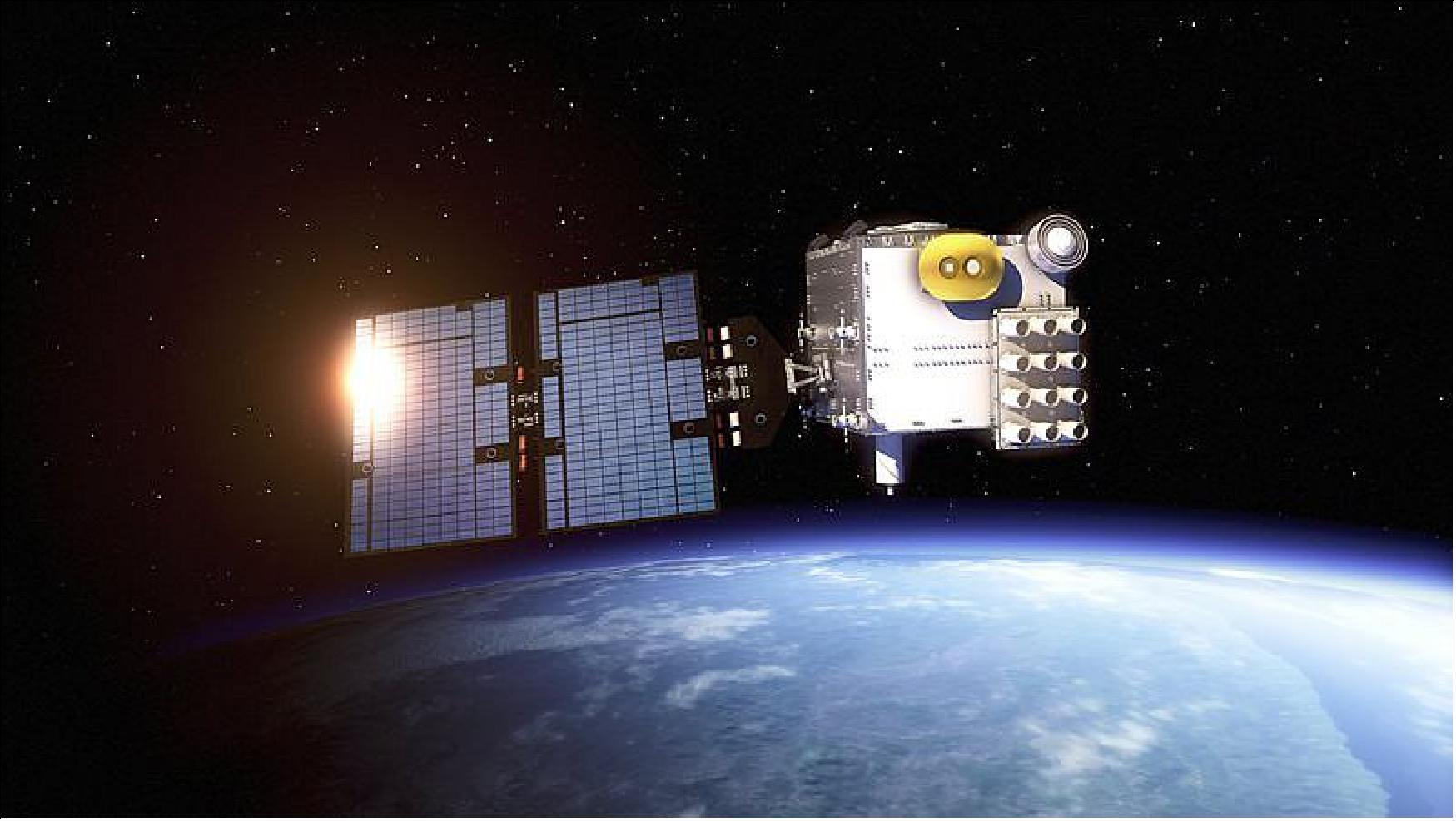
The FormoSat-7 / COSMIC-2 (Constellation Observing System for Meteorology, Ionosphere and Climate) constellation (simply known as FS-7/C-2) is an international collaboration between Taiwan (NSPO) and the United States (NOAA) that will use a constellation of 12 remote sensing microsatellites to collect atmospheric data for weather prediction and for ionosphere, climate and gravity research. NSPO/NARL (National Space Organization/National Applied Research Laboratories) is the designated representative for Taiwan and NOAA (National Oceanic and Atmospheric Administration) is the designated representative for the U.S. Note: NARL is also referred to as NARLabs.
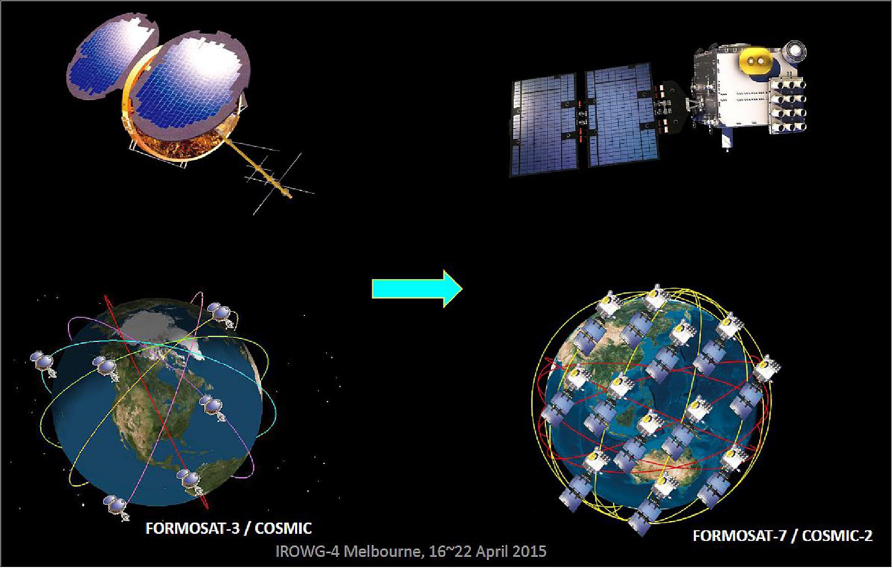
FormoSat-7 / COSMIC-2 is a follow-on mission to the FormoSat-3 / COSMIC mission to meet the RO (Radio Occultation) data continuity requirements of the user community. NOAA and NSPO intend to provide a high-reliability next generation satellite system.
The overall objective of FS-7/C-2 is to advance the capabilities of regional and global weather prediction (including severe weather prediction). The goal is to collect a large amount of atmospheric and ionospheric data primarily for operational weather forecasting and space weather monitoring as well as meteorological, climate, ionospheric, and geodetic research. It is expected to be a much improved constellation system consisting of a new constellation of 12 satellites for an operation mission.
The primary mission payload will be a TriG (third generation) GNSS-RO receiver and will collect more soundings per receiver by adding European Galileo system and Russia's GLONASS (Global Navigation Satellite System) tracking capability, which will produce a significantly higher spatial and temporal density of profiles. These will be much more useful for weather prediction models and also for the severe weather forecasting including typhoons and hurricane, as well as for the related research in the fields of meteorology, ionosphere and climate. 1) 2) 3) 4) 5) 6) 7) 8) 9) 10) 11) 12) 13) 14) 15) 16) 17) 18)
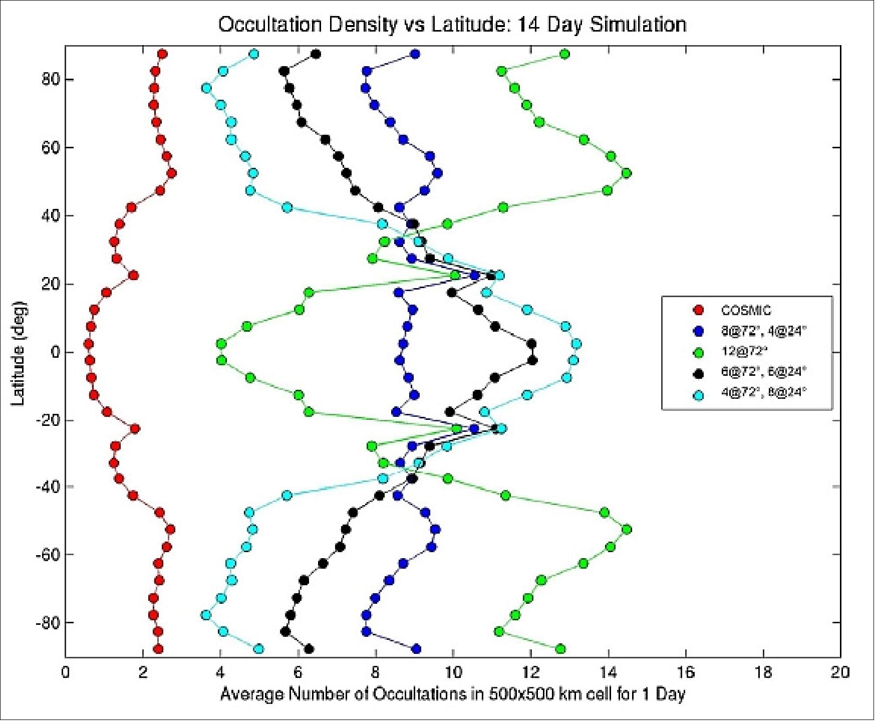
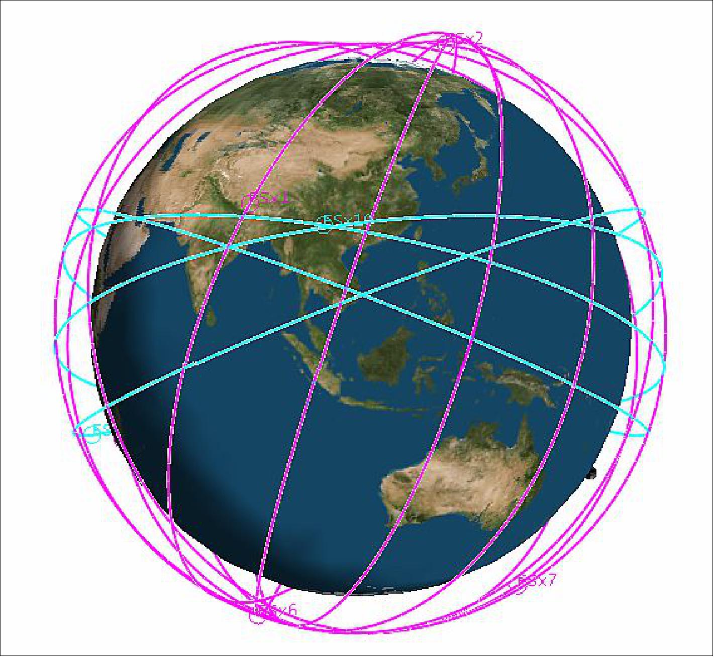
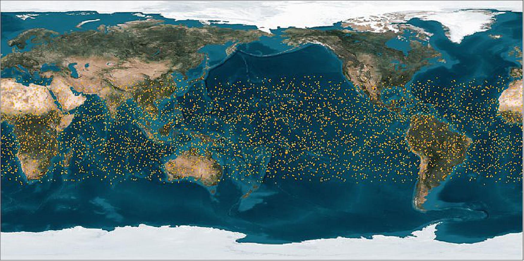
The constellation is planned to be comprised of 6 satellites at 72º inclination, and 6 satellites at 24º inclination, which will enhance observations in the equatorial region over what is currently being collected with FormoSat-3 / COSMIC. This constellation configuration was chosen because it provides the most uniform global coverage, as shown in Figure 1. Figure 1 shows the global sounding (data point) distribution versus the various orbital inclinations that were considered. 19) 20) 21)
This constellation will produce 8,000+ sounding profiles per day, compared to the approximate 2,000 soundings per day currently produced by FormoSat-3 / COSMIC due to the ability of FS-7/C-2 to track three navigation systems’ signals (GPS, GLONASS, and Galileo) versus the ability of FormoSat-3 / COSMIC to track only one (GPS).

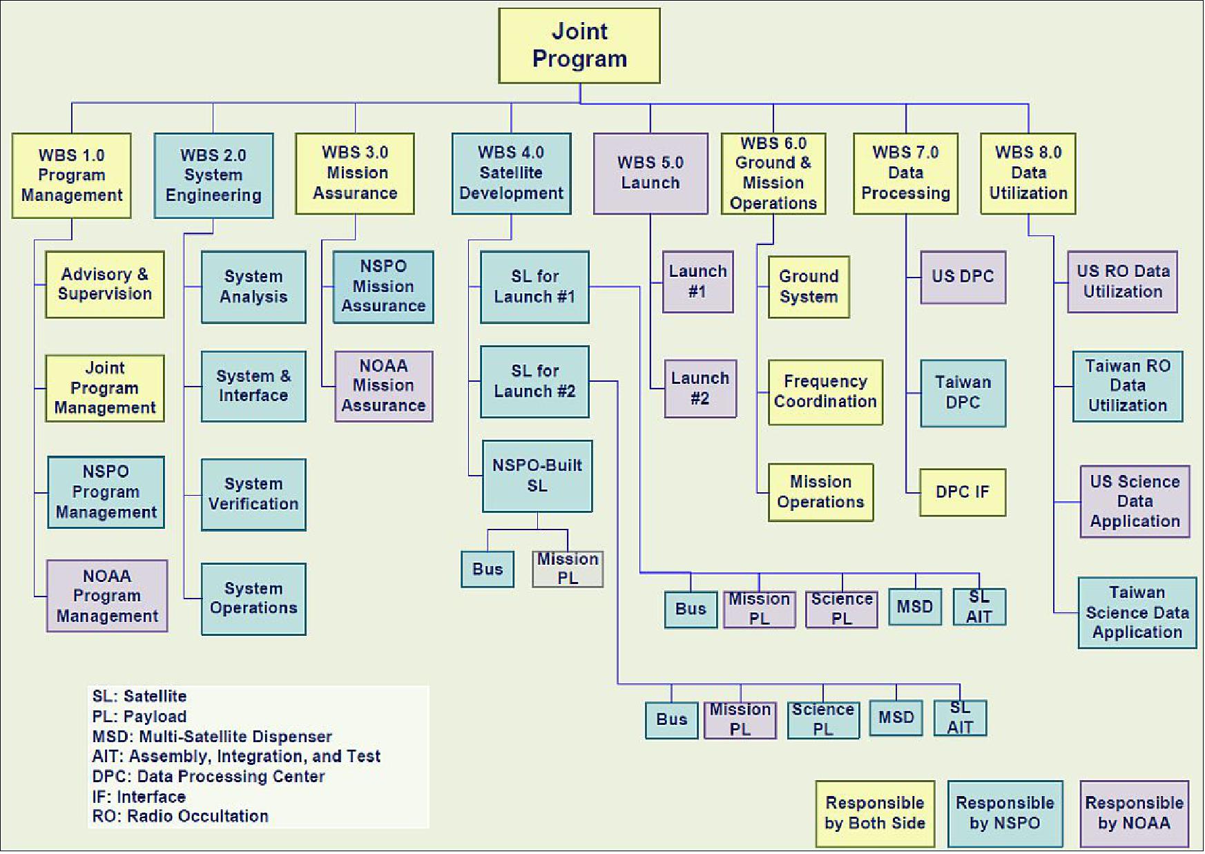
Responsibilities of FormoSat-7 / COSMIC-2 Partner Organisations
NSPO shall be responsible for:
• Acquisition, management, and deployment of satellites constellation
• Development and management of mission operations
• Modification and operations of the SOCC (Satellite Operations Command and Control) station and Taiwan’s TT&C station
• Acquisition and management of the Taiwan data processing center.
• Acquisition and management of the scientific payloads for second six satellites.
NOAA shall be responsible for:
• Acquisition and management of the GNSS-RO mission payload
• Overall management of the data analysis, application, and distribution segment
• Acquisition and management of the launch vehicle system
• Arrangement for and oversight of the remote ground receiving stations
• Acquisition and management of the scientific payloads for the first six satellites
• Acquisition and management of the data processing center in the U.S.
NOAA and NSPO shall be jointly responsible for the acquisition and management of the scientific payloads.
Partnership responsibilities of the FormoSat-7/COSMIC-2 mission (Ref. 13)
• Taiwan to provide: 12 spacecraft and integration of payload onto spacecraft, mission operations center, command & control station, and limited data recovery
• NASA providing: NRE (Non Recurring Engineering) for new sensor design
• USAF (US Air Force) to provide: Launch services for all 12 spacecraft and provide 12 AF payloads (2 per spacecraft) for 24º launch orbit
• NOAA to provide: 12 sensors, data recovery stations, command and control stations, payload data processing, and archival.
Functions | FormoSat-7 / COSMIC-2 mission | FormoSat-3 / COSMIC mission |
Mission | - Establish an operational mission for near real-time numerical weather prediction | - Demonstration of near real-time numerical weather prediction |
Spacecraft | - NSPO will provide 12 satellites for the joint mission and a spare satellite in space depending on the launch vehicle capability. | - NSPO defined system requirements |
Mission P/L capabilities | GPS / GALILEO / GLONASS tracking capabilities | GPS tracking capability |
Launch vehicle provision | NOAA will provide 2 dedicated launches into selected orbits and inclinations | Use the US Air Force Minotaur L/V through UCAR’s acquisition |
Ground system | NOAA’s strategy is to use U.S., European, Asian, and polar ground networks | Use of the USN ground stations for the first 2 years, and then service provision by NOAA's ground stations for the following 3~5 years |
Operations | High degree of automated ground system for a minimum of a 12 satellite constellation | 6 satellite constellation operations |
Data processing | - TACC (Taiwan Analysis Center for COSMIC) Upgrade | TACC & CDAAC Implementation |
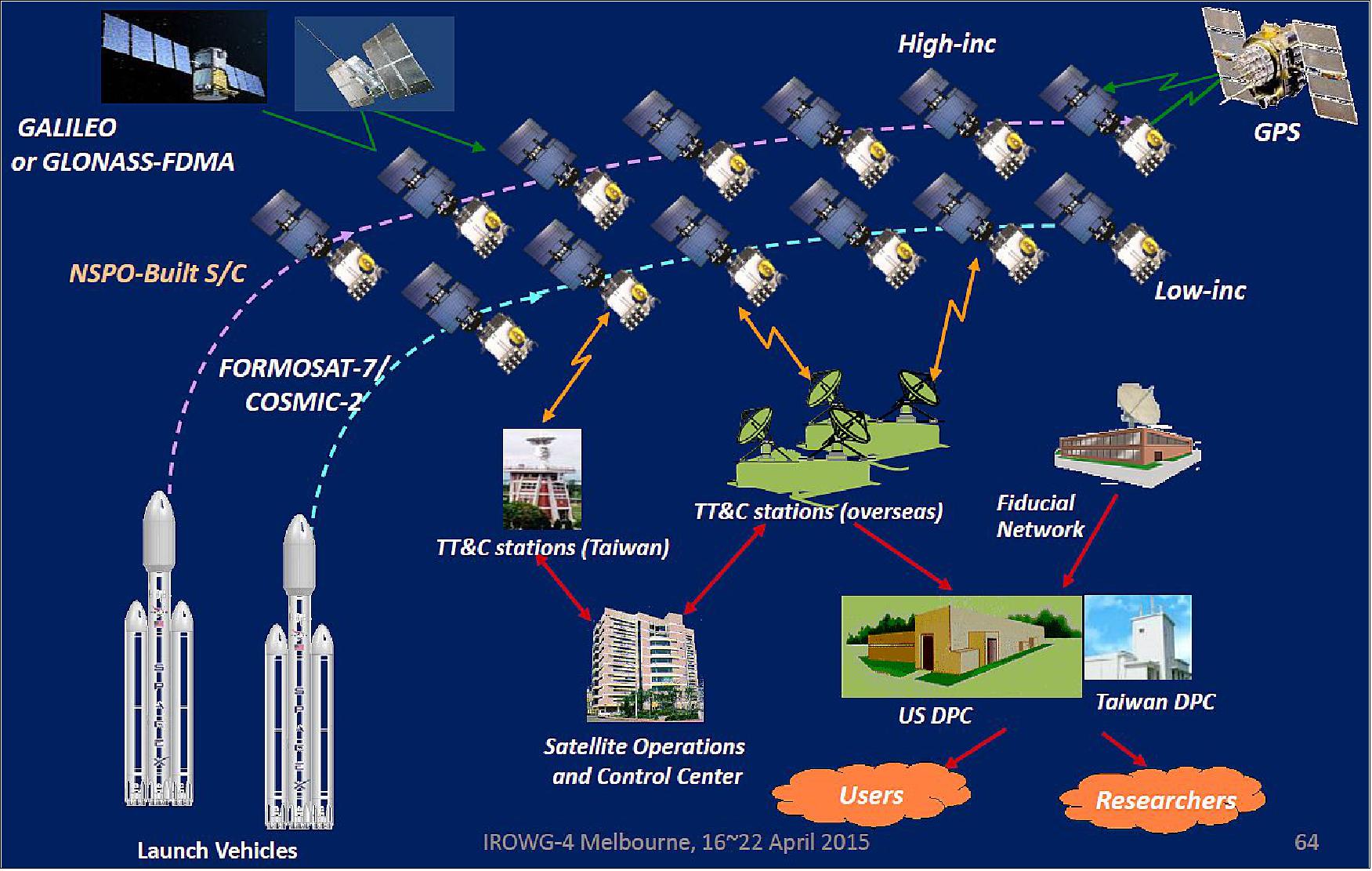
The project plan is to launch 2 rockets (Falcon-9) with 6 satellites on each rocket. They will be launched and then positioned into their final orbits (nominally 720 km altitude for the 72º inclination orbit and 520 km altitude for the 24º inclination orbit). 24)
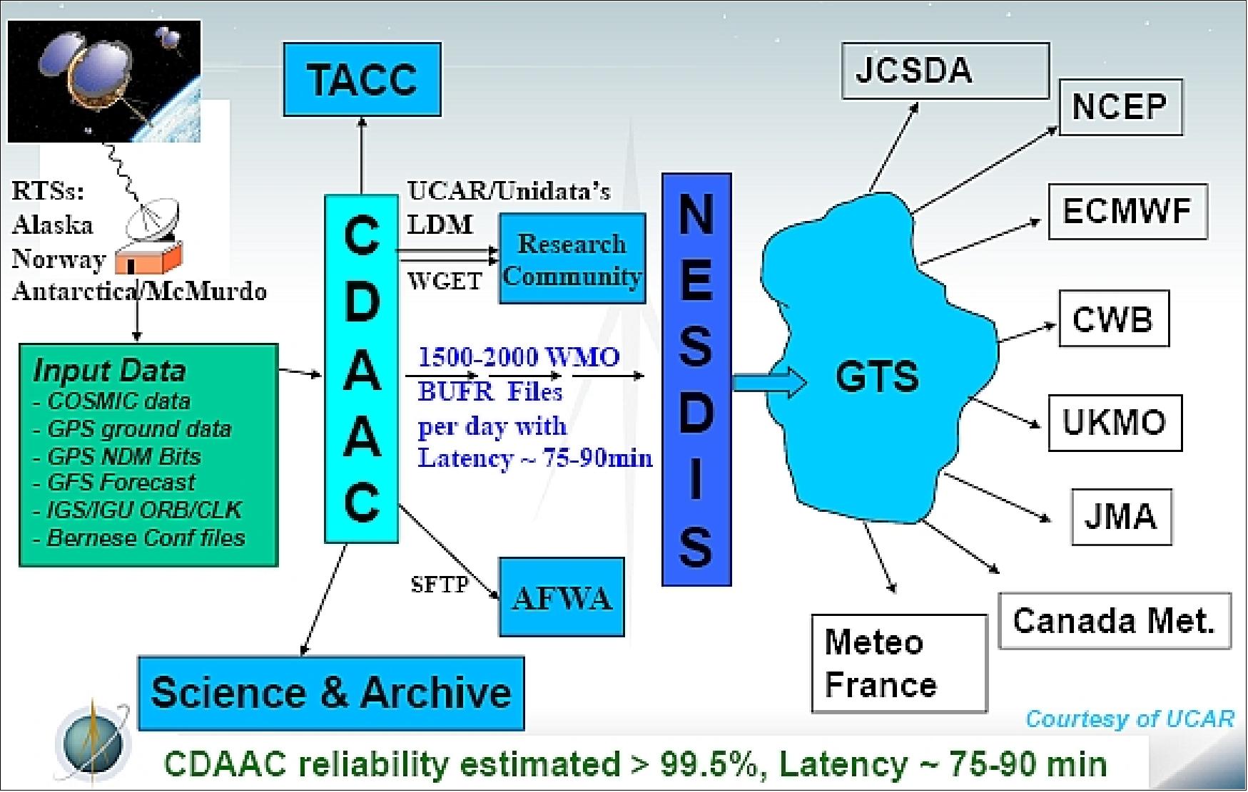
The original FormoSat-3 / COSMIC mission had an operational concept of allowing for one data downlink per orbit. The plan for FS-7/C-2 is to allow for 2 data downlinks per orbit, which will considerably reduce the data latency. Consequently, FS-7/C-2 will require more satellite ground stations for receiving the data. As with FormoSat-3 / COSMIC, the data collected by FS-7/C-2 will be downlinked to the tracking station, then transmitted to the COSMIC processing center CDAAC (COSMIC Data Analysis and Archive Center) in Boulder, CO, as well as to the Taiwan processing center TACC (Taiwan Analysis Center for COSMIC) for processing.
The processed products will then be provided to the NOAA GTS (Global Transmission System) for distribution to the worldwide weather prediction centers. Command and control for the FS-7/C-2 constellation will continue to be provided by the NSPO SOCC (Satellite Operations Control Center). Payload operational configurations will continue to be managed by a joint effort between UCAR (University Corporation for Atmospheric Research) and JPL (Jet Propulsion Laboratory) with NOAA and NSPO concurrence for updates and changes.
Item | First launch of 6 spacecraft | Second launch of 6 spacecraft |
Mission objectives | To be achieved after FOC (Full Operational Capability): | |
Mission constellation | 6 satellites (each of 215 kg wet estimated mass) | 6 (or 7) satellites (each of 215 kg wet estimated mass) |
Mission orbit | Inclination 24º, Parking altitude = 720 km | Inclination 72º, Parking altitude 520 km |
GNSS RO payload | TGRS (Tri-band GNSS ReceiverSystem), provided by NOAA/JPL | |
Science payload | - 2 band Radio Beacon scintillation instrument | Taiwan furnished payload |
Launch vehicle | Falcon Heavy (rideshare) carrying 6 satellites, ESPA ring | Falcon-9 carrying 7 satellites (including 1 spare) |
Launch schedule (expected) | Q2 2016 | Q3 2018 |
Max daily average data latency | 45 minutes neutral atmospheric data, 30 minutes ionospheric data | |
Communication architecture | SFTP (Scalable Fault-Tolerant Protocol) multicast via VPN (Virtual Personal Network) Internet | |
Ground stations | There shall be sufficient ground stations to meet the data latency requirement | |
Primary Data Processing Centers | US-DPC (UCAR) and Taiwan-DPC (TACC) | |
Mission duration | 10 years | |
Development Status
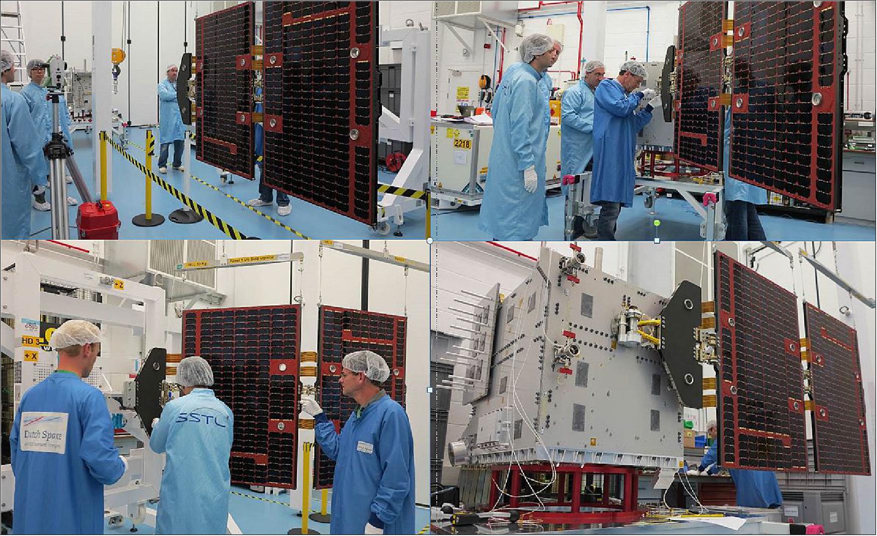
• December 2015: President Ma Ying-jeou of Taiwan, together with Premier Mao Chi-kuo, the Minister of Science and Technology and other dignitaries, visited the National Space Organization (NSPO) recently, where they were invited to view progress on the assembly and testing of the FORMOSAT-5 AND FORMOSAT-7 satellites. During the visit, President Ma Ying-jeou and Premier Mao Chi-kuo observed a planned spacecraft solar array deployment test being performed by NSPO on one of the six FORMOSAT-7 spacecraft, with support from SSTL. 25)
- Three of the FORMOSAT-7 spacecraft have already completed their integration and test campaign in Taiwan, and all six spacecraft are scheduled to be ready for their FRR (Flight Readiness Review) in the first-half of 2016, ahead of their launch later in the year.
• May 1, 2015: SSTL has delivered the first spacecraft for the FormoSat-7/COSMIC-2 weather forecasting constellation to NSPO (National Space Organization) in Taiwan, where it has successfully passed a series of systems checks. 26)
The first shipment of satellites (FM1 and FM3) arrived at NSPO on March 24, 2015. Note: the FM1 is also referred to as the PFM (Proto-Flight Model). 27) 28)
• March 2015: Amendment No.1 to the IA#1 through AIT/TECRO to update from 6-Satellite/1-Launch to 12-Satellite/2-Launch has been in work (Ref. 27).
• December 2014: SSTL completed PFM I&T (Integration and Test)) at SSTL UK (Ref. 27).
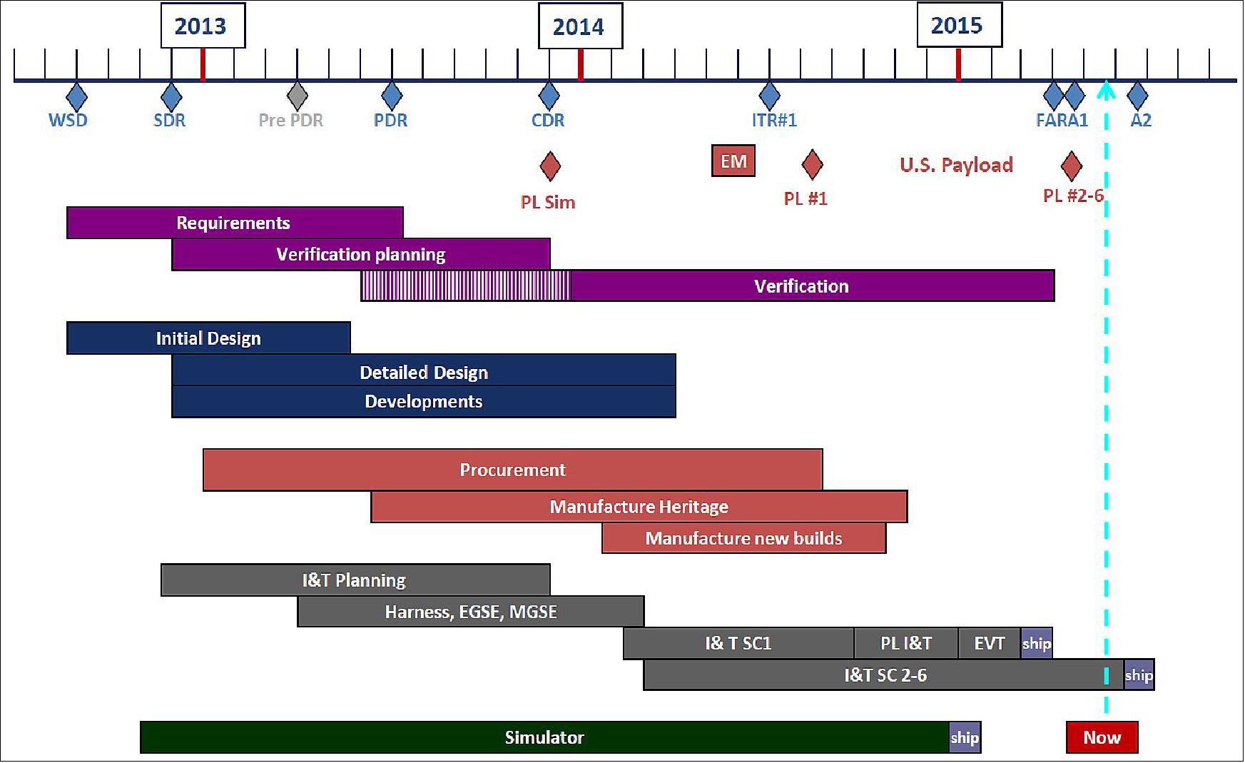
• The USAF and JPL held the Pre-Ship Review (PSR) for the TGRS units #2-6 on March 24, 2015. The PSR was successful and all sensors were shipped to Taiwan on April 3, 2015.
• Oct. 2014: All first flight units for TGRS, IVM, and RF Beacon were delivered to SSTL and successfully powered through the spacecraft (Ref. 18).
• TGRS (Tri-band GNSS Receiver System)
- Software updates enabling loads through spacecraft
- Units #2-4 completed and in storage
- Completion of development, I&T, and software efforts for #2-6 through UCAR – JPL contract
- TGRS Pre-Ship Review (PSR) for #2-6 will occur Oct/Nov 2014.
• IVM (Ion Velocity Meter)
- All parts are in inventory
- Unit #5 integrated and ready for test
- Test Readiness Review (TRR) was held on 17 September, 2014
- Delivery of units #2-6 expected 15 Jan 2015.
• RF Beacon
- Completed Beacon Electronics Unit (BEU) / Antenna Unit (AU) combined checkout
- Completion of development and I&T efforts for #2-6 through UCAR - SRI contract
- Delivery of RF Beacon Unit #2 expected March 2015.
• On Oct. 22, 2014, the NOAA-UCAR System Requirements Review (SRR) for the DPC (Data Processing Center) segment was successfully completed (Ref. 28).
• In FY 2014, the COSMIC-2 program became an officially NOAA funded program (Ref. 18).
• December 2013: Joint Team conducted Joint Program PDR-B at NSPO (Ref. 27).
• November 2013: NSPO conducted the Spacecraft CDR (Critical Design Review) at NSPO Taiwan (Ref. 27).
• December 2012: Taiwan & U.S. signed the IA#1 (Implementing Arrangement #1).
• The SRR (System Requirements Review) is scheduled for April 2011, the PDR (Preliminary Design Review) for June 2011, and the CDR (Critical Design Review) for September 2011.
• The Joint Program Office held the FDR (Feasibility Design Review) in May 2010 and the MDR (Mission Definition Review) in August 2010.
• The U.S.-Taiwan agreement that is the authorizing document for the FormoSat-7 COSMIC-2 program was signed by both parties in May 2010.
Function | FormoSat-7 design | FormoSat-3 design |
Spacecraft bus reliability | >0.66 for 5 years | >0.68 for 2 years |
Spacecraft mass | ~277.8 kg (wet) | 61 kg (w/ propellant) |
Attitude control performance | 3-axis linear control | 3-axis nonlinear control |
Data storage | Bus: > 256 MByte | 128 MByte |
Avionics architecture | Centralized architecture, radiation - hardness | Distributed architecture, (multiple avionics boxes) |
Electrical power | 10 % power margin | 10 % power margin |
Payload interface | Mission PL: TriG | Primary PL: GOX |
Spacecraft
On Sept. 6, 2012, NSPO awarded a contract to SSTL (Surrey Satellite Technology Ltd., UK) to built 12 minisatellites for the FormoSat-7/COSMIC-2 program. The spacecraft bus contract kick-off ceremony was held at NSPO (National Space Organization) and co-chaired by Dr. Guey-Shin Chang, Director General of NSPO, and Sir Martin Sweeting, Executive Chairman of SSTL. 29) 30)
The first phase is to deploy 6 satellites, each carrying an advanced GNSS receiver, to low-inclination-angle orbits. The launch is targeted in 2016.
Under the contract, SSTL will design and manufacture satellites for the FormoSat-7 program at its facilities in Guildford, UK, with the payloads being produced by NSPO's partners in the USA. NSPO will be responsible for the integration of the majority of the spacecraft at its facilities in Taiwan. The spacecraft design phase is already underway and SSTL is tailoring a new 200 kg platform to the mission requirements.
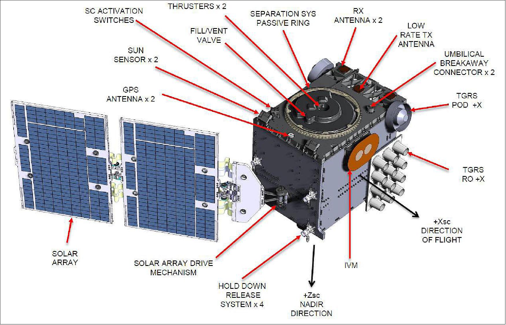
Spacecraft Design
The FS7/C-2 constellation will need to use the same mission control and mission operations ground system network as is being used for the FORMOSAT-3 system. The heritage baseline employed for the spacecraft is the SSTL-150 bus, which has been used on numerous previous missions. This configuration allows a more conventional design to be accommodated, without the need for extensive mass optimization and miniaturization. The avionics set provides a large degree of redundancy commensurate with mission lifetimes beyond 5 years. This bus is modified in some areas according to mission specific requirements. 31)
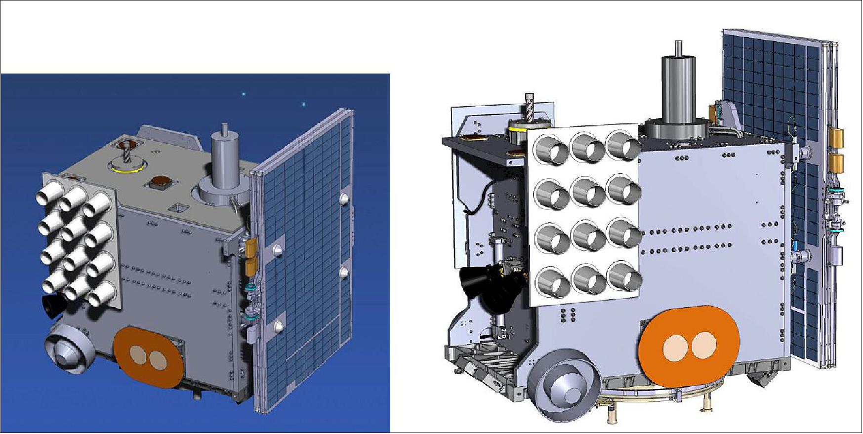
The propulsion system is based on heritage space components, and uses a monopropellant hydrazine system. Four thrusters are employed in order to permit spacecraft attitude control during propulsive maneuvers. Larger reaction wheels are employed to provide adequate control authority. Finally, star cameras are included to improve the attitude knowledge in support of the scientific payloads. One efficiency saving has been implemented by sharing capabilities cross the redundant OBCs (On-Board Computers) and redundant star camera processors, resulting in the need for just three computers. The resulting spacecraft avionics block diagram is shown in Figure 8.
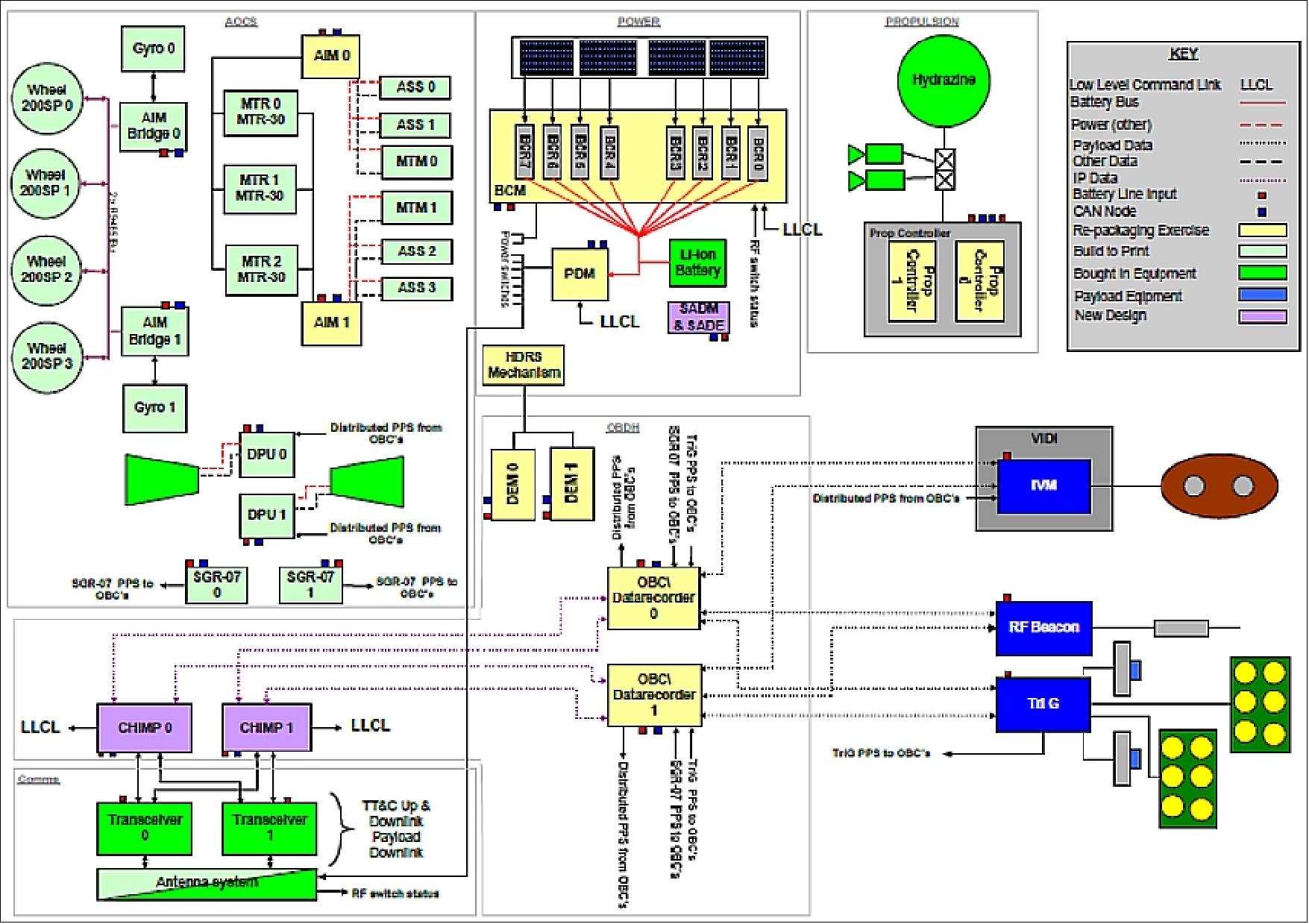
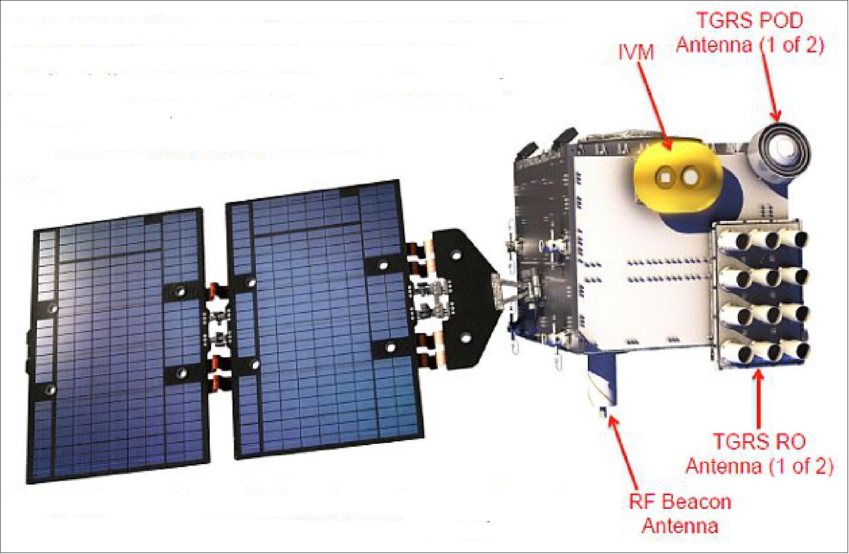
Note: TGRS (TriG-GNSS) = TriG GNSS Radio occultation System 32)
IVM (Ion Velocity Meter)
Spacecraft size (stowed) | 1000 mm x 1250 mm x 1250 mm |
Launch mass (wet) | 277.8 kg |
Total power / OAP ( Orbit Average Power) | 229.8 W (orbit average), battery capacity >22.5 Ahr |
Attitude control | 3-axis linear control |
Orbit control (propulsion) | Hydrazine monopropellant system, ~141 m/s |
Navigation | GPS receiver |
Communications | S-band TM/TC, 32 kbit/s uplink, up to 2 Mbit/s downlink |
Design life | 5 years, > 66% |
Availability | > 95% |
Launch compatibility | EELV (ESPA Grande Adaptor) |
Payload support | >2 Gbit data storage, 40 kg mass, 95 W OAP (Orbit Average Power) |
Design Features | - Dual redundant avionics |
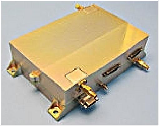
RF communications: Use of COM DEV’s S-band TT&C transponder, which was developed and certified under ESA's ARTES 3-4 program. The transponder combines the latest gallium nitride power amplifier technology with a flexible SDR (Software Defined Radio) system in a very light-weight, compact and efficient design, using commercially available components. The SDR is implemented on a field programmable gate array (FPGA), allowing the use of different modulation schemes and data rates to provide a flexible approach for different missions and mission phases. The transponder has previously been flown exactView-1 and is currently preparing to fly on a forthcoming M3MSat (Maritime Monitoring and Messaging Microsatellite) launch of Canada. 33)
Launch
The STP-2 (Space Test Program-2) rideshare mission of USAF, carrying 24 payloads, was launched on 25 June 2019 (06:30 UTC) aboard a SpaceX Falcon Heavy launch vehicle from Launch Complex 39A at NASA’s Kennedy Space Center. The STP-2 payload includes six FormoSat-7/COSMIC-2 satellites (primary payload), developed by NOAA and Taiwan’s National Space Organization to collect GPS radio occultation data for weather forecasting. The mission also carries several NASA technology demonstrations. The STP-2 mission is led by the Air Force Space Command’s Space and Missile Systems Center (SMC). The total IPS (Integrated Payload Stack) has a mass of 3700 kg. 34) 35) 36)
The overall objective of the STP-2 mission is to demonstrate the performance of the Falcon Heavy launch vehicle. That includes the multi-burn profile for the rocket’s upper stage as well as the reuse of side boosters that first flew on the previously Falcon Heavy mission, launching the Arabsat-6A satellite in April. The goal of SpaceX is to demonstrate the capabilities of the SpaceX Falcon Heavy launch vehicle and provide critical data supporting certification for future National Security Space Launch (NSSL) missions.
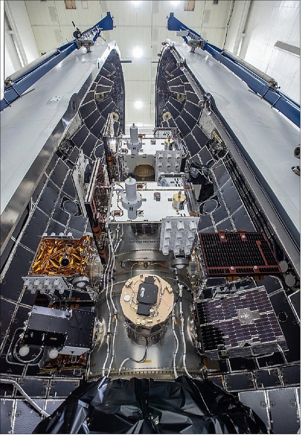
The Air Force agreed to use the side boosters from the Arabsat 6A mission to familiarize military officials with SpaceX’s process of recovering and refurbishing rocket hardware. It is the first time the Air Force has used previously-flown hardware on a military satellite launch.
“STP-2 is the government’s first launch on a SpaceX Falcon Heavy vehicle, and is one of the most challenging missions the Space and Missile Systems Center has ever launched,” said Col. Robert Bongiovi, director of SMC’s launch enterprise systems directorate. “We’re putting 24 research and development satellites into three separate orbits, with a first-ever four engine start and burn of the second stage.”
“The use of the previously-flown hardware is providing critical insight into reusability and quality assurance that will allow us to provide space access to the warfighter in a more cost-effective and expedient manner, and I really appreciate the efforts of our industry partner SpaceX to make this happen,” Bongiovi said Friday in a briefing with reporters.
“The plan is to recover all three cores, two coming back to land and one out on the drone ship,” Lauderdale said Friday. “SpaceX is looking for this opportunity to demonstrate this capability (for) continued reuse. We’re excited to be part of that journey.”
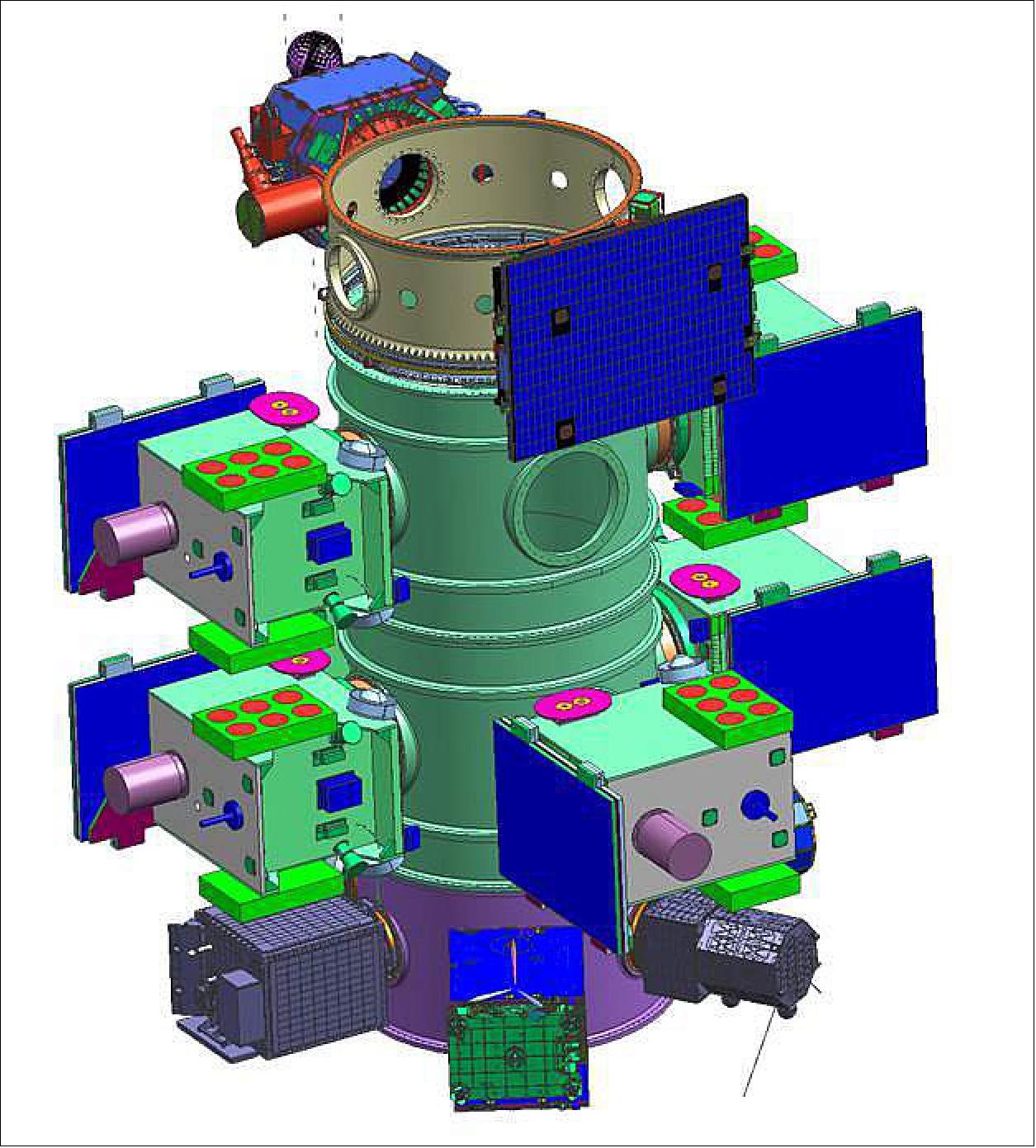
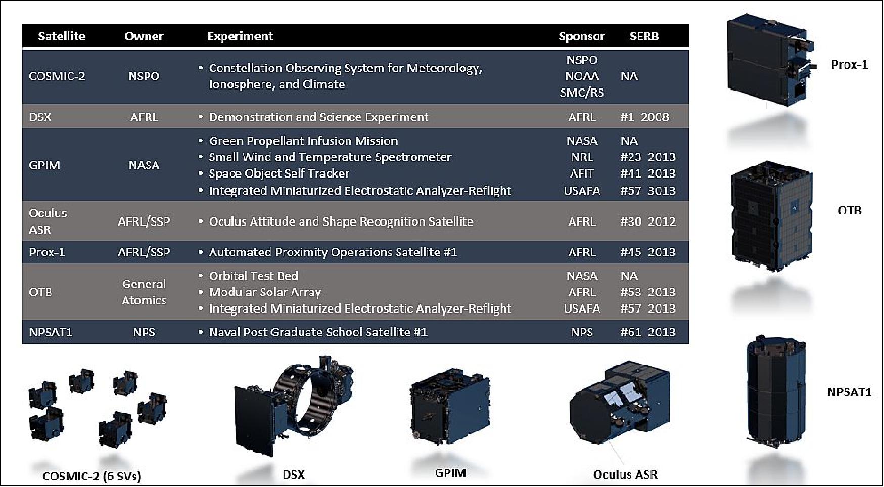
For SpaceX, demonstration of the Falcon Heavy capabilities was a primary purpose. National Security Space Launch New Entrant Certification, reusability of flight hardware, delivery of spacecraft to three different orbits, and additional flight data for future launches were all objectives. SMC had similar objectives to SpaceX. STP desired successful launch of the six COSMIC-2 spacecraft, the single DSX spacecraft, the five ESPA-class spacecraft, and 24U of CubeSats without spacecraft harming each other or the launch, so each spacecraft would have the opportunity to demonstrate technology, provide desired data, and advance relevant knowledge. In addition, fourteen of the experiments on board were selected through the DoD Space Experiments Review Board (SERB); access to space for SERB experiments is STP’s primary mission. COSMIC-2 and DSX were designated the co-primes of the STP-2 mission by virtue of their driving orbit requirements, with secondary priority given to the ESPA-class spacecraft, and tertiary priority given to the CubeSats. 37)
Secondary Payloads
• DSX (Demonstration and Science Experiments) mission of AFRL. The payload consists of four small technology demonstrations (600 kg) to study how spacecraft electronics respond to space radiation. DSX is to be delivered into an elliptical MEO (6-12,000 km altitude).
• GPIM (Green Propellant Infusion Mission), a demonstration minisatellite of NASA (~180 kg). 38)
• FalconSat-7, a 3U CubeSat mission developed by the Cadets of the U.S. Air Force Academy (USAFA) at Colorado Springs, CO.
• NPSat-1 (Naval Postgraduate School Satellite-1) of the Naval Postgraduate School, Monterey, CA. A microsatellite of 86 kg.
• OCULUS-ASR (OCULUS-Attitude and Shape Recognition), a microsatellite (70 kg) of MTU (Michigan Technological University), Houghton, MI, USA.
• Prox-1, a microsatellite (71 kg) of SSDL (Space Systems Design Laboratory) at Georgia Tech.
• LightSail-2 of the Planetary Society, a nanosatellite (3U CubeSat, 5 kg) will be deployed from the parent satellite Prox-1.
• ARMADILLO of UTA (University of Texas at Austin), a nanosatellite (3U CubeSat) of ~ 4 kg.
• E-TBEx (Enhanced Tandem Beacon Experiment), a tandem pair (3U CubeSats) of SRI International.
• TEPCE (Tether Electrodynamics Propulsion CubeSat Experiment), a 3U CubeSat (3 kg) of NPS (Naval Postgraduate School).
• CP-9 , a joint CP-9/StangSat experiment, which is a collaboration between PolySat at Cal Poly and the Merritt Island High School, and is sponsored by the NASA LSP (Launch Services Program). CP-9 is a 2U CubeSat while StangSat is a 1U CubeSat.
• PSat-2 (ParkinsonSat-2), a student built 1.5U CubeSat of USNA (US Naval Academy) with a mass of 2 kg.
• BRICSAT-2, a student built 1.5U CubeSat of USNA (US Naval Academy) to demonstrate a µCAT electric propulsion system and carry a ham radio payload.
• OTB-1 (Orbital Test Bed-1) a minisatellite built by SSTL (based on the SSTL-150 bus, 138 kg) and owned by General Atomics' Electromagnetic Systems Group (GA-EMS) of San Diego. One of the hosted payloads is NASA's DSAC (Deep Space Atomic Clock), a technology demonstration mission with the goal to validate a miniaturized, ultra-precise mercury-ion atomic clock that is 100 times more stable than today’s best navigation clocks.
• Ballast: Required in original mission contract to be delivered into MEO (6-12,000 km altitude); mass (< 5000 kg) and composition currently unknown.
Note: Several of the secondary missions are described in separate files on the eoPortal.
Orbits
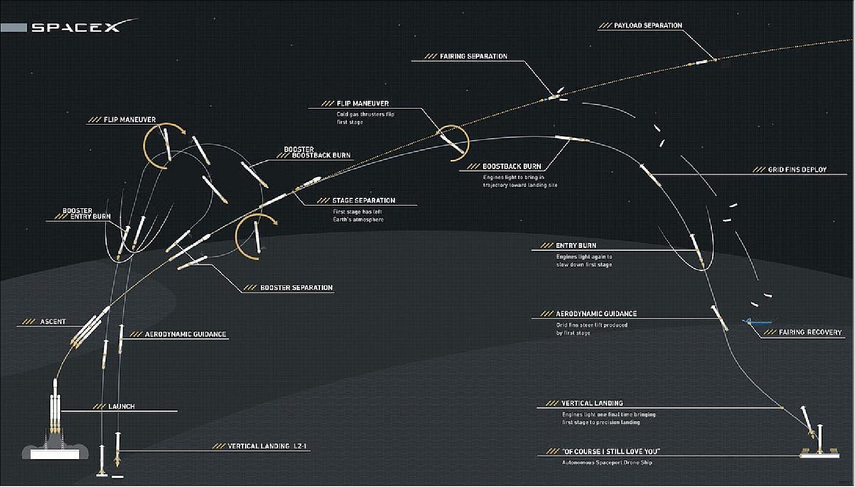
The STP-2 mission will be among the most challenging launches in SpaceX history with four separate upper-stage engine burns, three separate deployment orbits, a final propulsive passivation maneuver and a total mission duration of over six hours. It will demonstrate the capabilities of the Falcon Heavy launch vehicle and provide critical data supporting certification for future National Security Space Launch (NSSL) missions. In addition, [the USAF] will use this mission as a pathfinder for the [military’s systematic utilization of flight-proven] launch vehicle boosters.
The three orbits of the STP-2 mission for spacecraft deployment are:
1) The small secondary CubeSat satellites will be deployed into an elliptical orbit of ~300 x 860 km, inclination of ~28º. These are: OCULUS-ASR, TEPCE, E-TBEx, FalconSat-7, ARMADILLO, PSAT-2, BRICSAT, and CP-9/StangSat.
2) The second deployment batch of the STP-2 mission will occur at a circular altitude of 720 km and an inclination of 24º.
- Deployment of LightSail-2, Prox-1, and NPSat-1
- Deployment of OTB-1 with NASA's DSAC and GPIM
- The six FormoSat-7/COSMIC-2 satellites will be deployed next into an initial circular parking orbit of 720 km. Eventually, they will be positioned in a low inclination orbit at a nominal altitude of ~520-550 km with an inclination of 24º (using their propulsion system). Through constellation deployment, they will be placed into 6 orbital planes with 60º separation.
3) The third and final deployment will be the Air Force Research Lab's DSX spacecraft as well as the ballast, which will be delivered to an elliptical MEO (Medium Earth Orbit) with a perigee of 6000 km and an apogee of 12000 km, inclination of 43º.
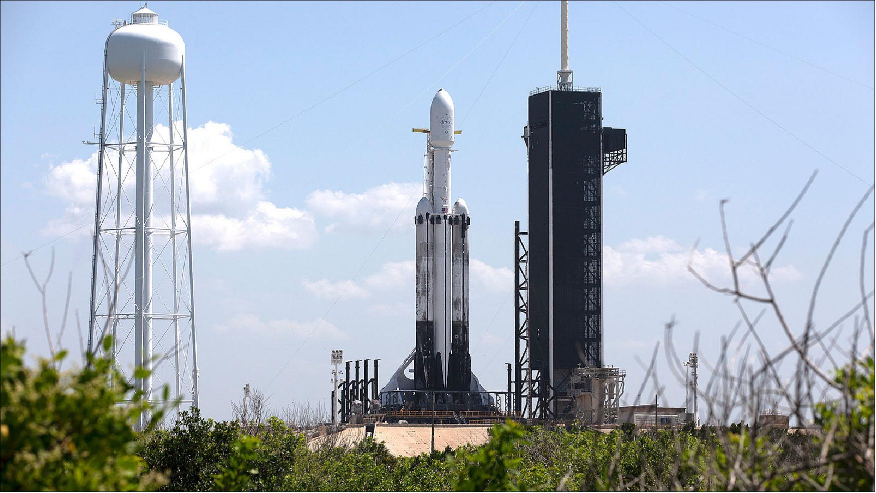
Figure 17: A SpaceX Falcon Heavy rocket is ready for launch on the pad at Launch Complex 39A at NASA's Kennedy Space Center in Florida on June 24, 2019 (image credit: NASA)
Launch of the Second Set of the FormoSat-7/COSMIC-2 Satellite Cancelled 39)
As of October 2017, the U.S. National Oceanic and Atmospheric Administration (NOAA) and Taiwan’s Ministry of Science and Technology agreed this month to scrap plans for a second set of next-generation GPS radio occultation weather satellites after determining the joint project faced an unwinnable battle to secure funding.
In a joint memorandum obtained by SpaceNews, the two agencies concluded that they would not pursue development of a second set of six COSMIC-2 (Constellation Observing System for Meteorology, Ionosphere, and Climate) satellites, known as COSMIC-2B, citing challenges to secure support in both countries.
FormoSat-7 / COSMIC-2 was originally planned to feature two sets of six satellites to collect GPS radio occultation data used in weather forecasting. An initial set of six satellites, known as COSMIC-2A, has been built and is scheduled for launch as part of the U.S. Air Force’s STP (Space Test Program 2) mission, launching on a SpaceX Falcon Heavy in early 2018.
The COSMIC-2A satellites, operating in low-inclination orbits, were to be complemented by six satellites collectively known as COSMIC-2B that would operate in highly-inclined orbits. COSMIC-2B would be a replacement for the original Formosat-3/COSMIC satellites, launched into high-inclination orbits in 2006.
The satellites measure signals from GPS and other navigation satellites as they skim through the atmosphere, using them as a probe of temperature and humidity conditions that fed into weather forecast models. Studies have concluded that GPS radio occultation data is among the best sources of data for improving the accuracy of forecasts.
However, the memo, prepared by a joint Executive Steering Committee of U.S. and Taiwanese officials, found that both countries were finding problems financing the payloads, satellites and launch of the COSMIC-2B system.
“At the senior-level meetings on June 19-20, 2017, NOAA and NSPO both acknowledged the difficulty in finding a viable path forward in exercising the option for COSMIC-2B,” the memo stated. NSPO is Taiwan’s space agency, the National Space Organization.
NOAA, responsible for the COSMIC-2 payloads, did not receive any funding for the COSMIC-2B payloads in the fiscal year 2017 omnibus appropriations bill enacted in May. The agency’s fiscal year 2018 request, released several weeks later, also requested no funding for COSMIC-2B payloads.
Uncertainty about funding for those payloads, in turn, created problems for NSPO, responsible for the satellites. “NSPO has had difficulty to secure the 2nd set of FORMOSAT-7 from the Ministry of Science and Technology (MOST) budget since 2014 because the funding of the second set of mission payloads remains uncertain,” the memo stated.
Launch options for the COSMIC-2B mission were also an issue. NASA had proposed flying four the satellites as secondary payloads on the launch of the agency’s Surface Water Ocean Tomography mission, scheduled for April 2021 on a SpaceX Falcon 9. However, NSPO “would face technical, schedule and resource challenges” in getting the satellites ready in time for that launch. The memo didn’t state what plans, if any, existed for the other two COSMIC-2B satellites.
NSPO added that its ministry had given direction “not to pursue FORMOSAT-7 Launch #2 given new priorities,” which were not stated in the memo.
That memo concluded that the Executive Steering Committee “decided not to exercise the option for COSMIC-2B/FormoSat-7.” The joint program would proceed with the six COSMIC-2A satellites but “will not pursue additional FormoSat-7/COSMIC-2 satellites” beyond them. The memo was signed by NOAA officials Oct. 6 and by their Taiwanese counterparts on Oct. 16, 2017.
COSMIC-2 had become controversial in the U.S. because of perceptions by companies developing their own GPS radio occultation (RO) systems that the government was competing with them. NOAA, under pressure from Congress, started a pilot program in 2016 to purchase commercial GPS radio occultation data, awarding contracts to GeoOptics and Spire that concluded earlier this year.
In report language accompanying the 2017 omnibus appropriations bill, Congress indicated that it wanted to NOAA to consider commercial sources of that data alongside development of the COSMIC-2B satellites.
“Within 90 days of enactment of this Act, NOAA shall submit an analysis of options for acquiring polar RO data that includes a cost analysis of all alternatives and demonstrates that NOAA has thoroughly reviewed potential commercial RO sources,” the act stated in the section discussing the lack of funding for COSMIC-2B.
“If the plan proposes moving forward with additional COSMIC-2 satellites,” it continued, “the plan shall include the total cost to the U.S. government of developing, procuring, launching, and operating COSMIC-2 polar orbiting satellites, including how they would be launched and what Federal agency would incur that cost.”
NOAA has not disclosed the outcome of analysis of data collected in the initial phase of the pilot program, where only Spire was able to provide GPS RO data. The memo, though, stated that NOAA didn’t yet believe commercial data was ready for routine use. “While the commercial sector is not at present a viable source for [GPS radio occultation] data for operational use, NOAA will continue to evaluate it as a potential source for the future,” the memo stated.
The Weather Research and Forecasting Innovation Act of 2017, signed into law in April, authorized continued development of a government-funded satellite system to collect GPS radio occultation data. The bill calls on NOAA to “complete and operationalize” the COSMIC-2 mission, placing satellites into both equatorial and polar orbits.
Mission Status
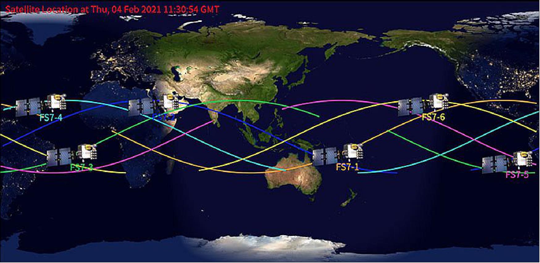
• February 8, 2021: President Tsai Ing-wen declared in her inauguration speech last year that the space industry is one of the country's six core strategic industries. As an important indicator of Taiwan's space technology, FORMOSAT-7 is also the largest international scientific cooperation program between Taiwan and the United States in recent years. There is good news from FORMOSAT-7 a few days ago that all 6 satellites have been successfully deployed in mission orbits at the altitude of 540 to 550 kilometers on February 3, 2021, and 24-hour evenly distributed atmospheric and ionospheric observation data can be provided for the application of meteorological forecast and space weather monitor. 40)
- The FORMOSAT-7 program is jointly implemented by National Space Organization (NSPO) of National Applied Research Laboratories (NARLabs) under the Ministry of Science and Technology (MOST) in Taiwan and the National Oceanic and Atmospheric Administration (NOAA) in the United States. A constellation of 6 FORMOSAT-7 satellites use the occultation technology to observe data and receive signals from the US GPS and Russian GLONASS global positioning satellites. They can provide daily atmospheric vertical profile data at about 4,000 points between 50 degrees north and south latitudes around the world, which can make up for a large amount of observational data that is extremely scarce in tropical ocean areas, which will greatly help the improvement of global weather forecast accuracy. It has been confirmed by international meteorological operation units that the FORMOSAT-7 data can reduce the 24-hour weather forecast error by 10~11% when the observation points are not evenly distributed.
- FORMOSAT-7 satellites aboard SpaceX's Falcon Heavy rocket were launched at the Kennedy Space Center in Florida, U.S., on June 25, 2019, Taiwan time, and then they reached a parking orbit of 720 km. After 1 month of satellite health checks and 18 months of orbit-transfer operations, all 6-satellite deployment to the mission orbit was completed on February 3, 2021.
- Before the deployment is completed, FORMOSAT-7 has already performed its mission. The atmospheric observation data was released globally in synchronization with NOAA on March 7, 2020. The ionospheric data obtained by receiving GPS satellite signals was released and announced together with the University Corporation for Atmospheric Research (UCAR), USA, on September 15, 2020. The FORMOSAT-7 data is currently being used by many meteorological centers and research institutes around the world. Among them, NSPO, Central Weather Bureau (CWB), National Central University (NCU), and National Cheng-Kung University (NCKU) teams in Taiwan, as well as the scientific teams under UCAR and NOAA in the United States make the most use of the FORMOSAT-7 data. In addition to reducing the overall weather forecast error by 10~11%, it can forecast typhoon generation earlier, improve the typhoon forecast track, and effectively monitor changes in space weather.
- In the future, NSPO will continue to work hard to guard FORMOSAT-7, the role of clairvoyance, observing the weather changes thousands of miles away, providing the best service to help CWB and major meteorological centers around the world to grasp the situation earlier, so that the people can make preparation as soon as possible to reduce disaster losses.
• April 2020: ECMWF (European Centre for Medium-Range Weather Forecasts) started assimilating GNSS radio occultation (GNSS-RO) measurements from the FORMOSAT-7/COSMIC-2 mission (COSMIC-2 hereafter) on 25 March 2020. This joint Taiwan–United States mission is a constellation of six satellites, providing around 5,000 occultations per day between ±40 degrees latitude. The satellites were launched on 25 June 2019 and declared operational on 25 February 2020, and the data became available on the Global Telecommunication System on 16 March 2020. 41)
- COSMIC-2 represents a significant increase in the number occultations available for operational assimilation at ECMWF, from around 3,000 per day (of which around 1,800 come from EUMETSAT’s MetOp satellites) to around 8,000. These new measurements have a large impact in the tropics, improving temperature, humidity and wind forecasts in the short and medium range.
- Early COSMIC-2 results were presented by UCAR and NSPO at the EUMETSAT ROM SAF IROWG workshop in September 2019 (see https://www.romsaf.org/romsaf-irowg-2019/en/). For example, it was demonstrated that measurements made with the GPS and GLONASS GNSS systems were of similar quality below 35 km. The differences above this height were relatively small, when compared with assumed error statistics used to assimilate GNSS-RO data.
Use of COSMIC-2 at ECMWF
- UCAR made the first COSMIC-2 non-operational data available in October 2019, initially for technical testing in NWP (Numerical Weather Prediction) systems. As more data became available, they were used at ECMWF for extended impact experiments.
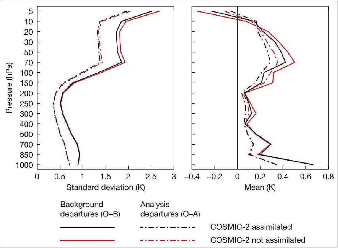
- ECMWF has initially adopted a conservative approach to COSMIC-2 by assimilating the data in the same way as is done for other operational GNSS-RO missions. This produced good results in experiments from late September 2019 to March 2020. It is a sign of improvement when the short-range forecast is closer to data from other observing systems. Such improvements are found for almost all in-situ and satellite observation types in the tropics (see the figure for an example). Perhaps most significantly, there is a clear and consistent impact on the forecast fit to a range of observing systems that are sensitive to tropospheric water vapor.
- Medium-range forecast scores are also promising. We obtain large forecast improvements for tropical stratospheric zonal (latitudinal) winds. The impact is statistically significant out to 10 days, verified against observations. In the northern hemisphere extratropics, the reduction in geopotential height forecast errors from the 500 hPa level and above is statistically significant out to 3–4 days. There are also global improvements in stratospheric geopotential height and temperature biases.
Summary and Outlook
- The COSMIC-2 mission represents a large increase in the GNSS-RO data available for operational NWP applications. First ECMWF impact experiments with this data have been extremely promising, and they led to the operational implementation on 25 March 2020. The impact of COSMIC-2 on the forecast fit to observing systems sensitive to tropospheric water vapor represents an important step forward for GNSS-RO.
- The use of COSMIC-2 is still quite conservative, and ECMWF will try to improve on the exploitation of this data in the future. We will test extending the use of the data higher into the mesosphere. In addition, following promising work conducted recently at the UK Met Office, we will investigate the use of observation uncertainty estimates that differ for the various GNSS-RO datasets.
• March 12, 2020: Taiwanese and US officials have just announced that data gathered by the FormoSat-7/COSMIC-2 satellite constellation, launched last year, will now be released daily. The announcement follows 3 months of trials, and although currently the data released will be from the previous day, the aim is to release near real-time data in the future. 42)
- This is great news for SSTL as we designed and manufactured the satellite platforms and provided support to NSPO on payload integration, system testing, launch preparations, launch campaign and in-orbit commissioning. Since the launch in June last year we have continued to monitor progress keenly and support NSPO during the first few months of service of this weather forecasting constellation.
- The FORMOSAT-7/COSMIC-2 program is a constellation with 6 satellites for observing and monitoring the global meteorology, climate and ionosphere. Each of the satellites is carrying a suite of payloads including an advanced GNSS receiver to low-inclination-angle orbits and will collect atmospheric data at low- and mid-latitudes to provide more sounding data to improve regional and global weather forecasting.
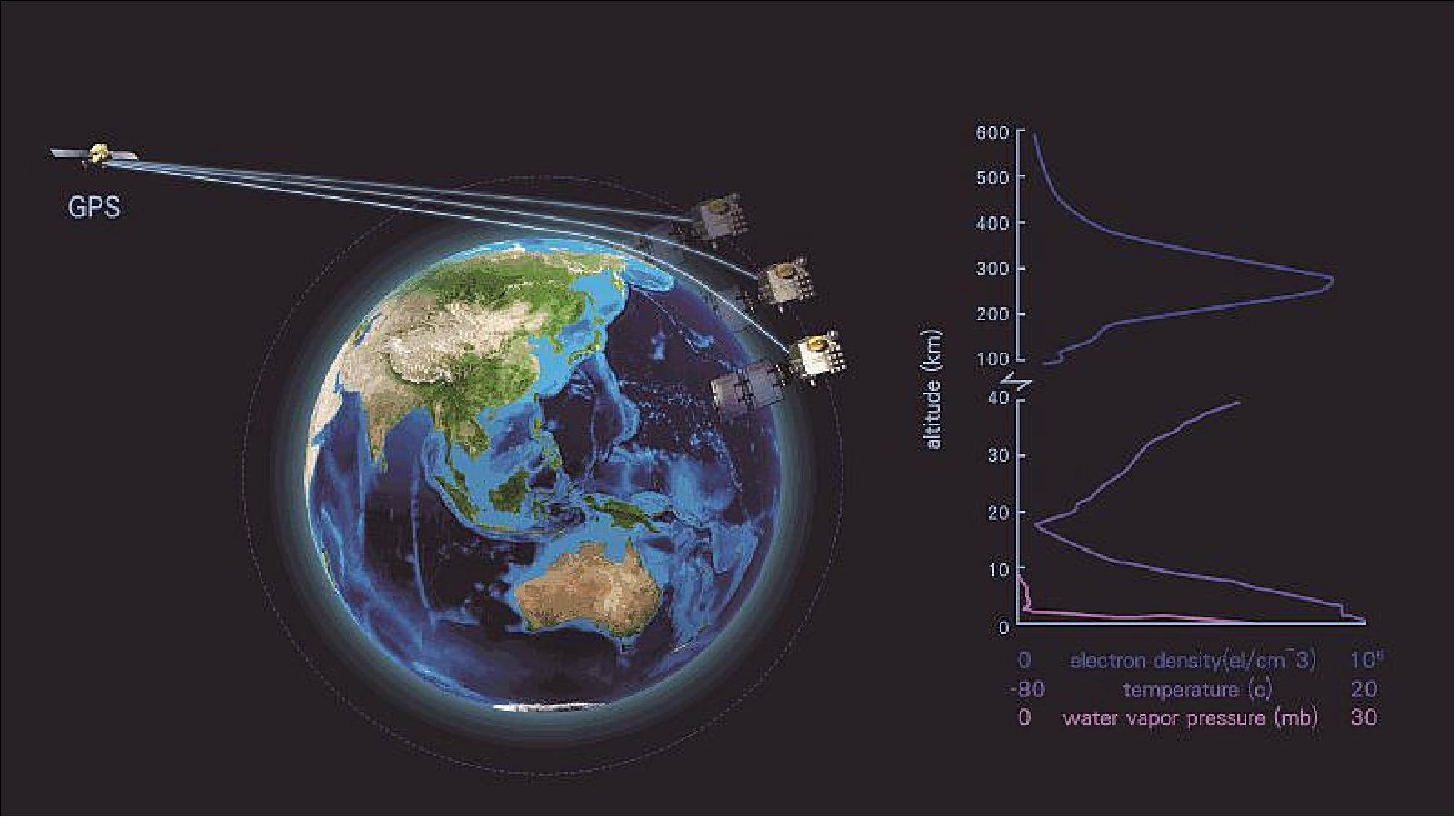
- Two satellites are already in their planned orbits at 550 km, with the remaining 4 satellites due to reach their target orbits by February next year. The satellites will be deployed to 6 different orbital planes from where the constellation can provide more than 4000 atmospheric profiles each day to a numerical weather prediction model. This large data volume will improve weather forecast accuracy, and several major weather organizations around the world have already begun to make use of this data. In addition to neutral atmosphere data, such as temperature and moisture profiles, the FormoSat-7/COSMIC-2 Constellation can also measure the electron density of ionosphere, which can be applied to nowcast and forecast of space weather.
- Users can download the neutral atmosphere data from Taiwan’s Central Weather Bureau's website: https://web.archive.org/web/20220925075413/https://tacc.cwb.gov.tw/v2/download.html. The data product from the previous day will be posted at 02:00 UTC every day. Space weather status can be retrieved from website https://swoo.cwb.gov.tw.
- The FORMOSAT-7/COSMIC-2 program is conducted under a joint agreement between the American Institute in Taiwan and the Taipei Economic and Cultural Representative Office in the United States, with NOAA (National Oceanic and Atmospheric Administration) and NSPO as the designated representatives.
• June 26, 2019: At 2:30 a.m. (06:30 UTC) on Tuesday, June 25, SpaceX launched the STP-2 mission from Launch Complex 39A (LC-39A) at NASA’s Kennedy Space Center in Florida. Deployments began approximately 12 minutes after liftoff and ended approximately 3 hours and 32 minutes after liftoff. Following booster separation, Falcon Heavy’s two side boosters landed at SpaceX’s Landing Zones 1 and 2 (LZ-1 and LZ-2) at Cape Canaveral Air Force Station in Florida. 43)
• June 25, 2019: The successful launch of 6 satellites for the FORMOSAT-7 joint US-Taiwanese weather forecasting constellation marks the start of another SSTL-enabled space mission, a cause for celebration at SSTL’s UK HQ. The launch on the SpaceX Falcon Heavy rocket from the Kennedy Space Center was attended by SSTL staff including Managing Director, Sarah Parker who said “We are very proud of our role as space mission enablers and, hot on the heels of TeleSat LEO Phase 1 satellites’ first ever demo of 5G connectivity, we are delighted that our smallsats expertise has once again helped our customers achieve their ambitions. We congratulate our customers, NSPO in Taiwan, and NOAA in the United States on the successful launch of their constellation and look forward to following their mission journey as they move through commissioning and into start of operations.” 44)
- FORMOSAT-7, also known as COSMIC-2 in the US, is a joint constellation meteorological satellite mission between Taiwan and the United States for observing and monitoring the global meteorology, climate, and ionosphere. In addition to two science payloads for detecting ionospheric data, each of the 6 satellites in the constellation is carrying an advanced GNSS receiver to low-inclination-angle orbits and will collect atmospheric data at low and mid latitudes to provide sounding data to improve regional and global weather forecasting. The processed data will be provided by two data processing centers located in Taiwan and USA.
- SSTL provided the platforms for this next-generation Global Navigational Satellite System Radio Occultation data constellation, enabling our customer, NSPO of Taiwan, to continue its participation in an internationally recognized science mission at the best possible value for money. Collaborating with SSTL also enabled NSPO’s engineers to work hand-in-hand with SSTL’s engineering team throughout the program, gaining world-class small satellite expertise in the full range of satellite mission capability including design, assembly, test and in-orbit operations.
- As a continuation of this program, NSPO is now developing its own FORMOSAT-7 platform, named TRITON, using some of SSTL’s hardware under license in its own satellite structure and avionics. The satellite is scheduled to be launched in 2021.
- The first fully integrated and tested satellite for the FORMOSAT-7 constellation was completed at SSTL in the UK and delivered to NSPO in Taiwan in 2015. The other 5 satellites in the constellation were manufactured and assembled by SSTL in the UK and delivered to Taiwan where payload assembly and testing was completed at NSPO’s facility as part of the knowledge transfer program. The payloads for the satellites were provided by NASA (JPL), the US Air Force and the University of Texas and were integrated to the completed platforms by the NSPO team, with support from SSTL. SSTL engineers also provided launch site support and are providing technical in-orbit operational support to NSPO’s team who will be performing in orbit commissioning of the spacecraft from their control center in Taiwan.
Sensor Complement (TGRS, IVM, RF Beacon)
Initially in the project, the TGRS (Tri-band GNSS Receiver System) was referred to as TriG-RO [Tri-GNSS (GPS+ Galileo+GLONASS) Radio Occultation receiver].
TGRS (Tri-band GNSS Receiver System)
NASA/JPL (Jet Propulsion Laboratory) is developing a next-generation GNSS space science receiver, the TriG receiver. The receiver will upgrade the capabilities offered by the current state of the art BlackJack/IGOR GPS science receivers in order to meet NASA’s decadal survey recommendations. This includes the ability to track not only GPS, but additional GNSS signals, including Galileo, CDMA GLONASS and Compass.
Most of the low level signal processing will be done inside multiple reconfigurable FPGAs, which can be updated post-launch to track new in-band GNSS signals as they become available. TriG will greatly increase the amount and quality of data by employing digital beamforming to direct multiple simultaneous high-gain beams at GNSS satellites.
With this new architecture and the availability of Galileo, GLONASS and Compass signals, many more occultations will be observed each day. The TriG receiver will have two processors, one for performing POD (Precise Orbit Determination), and the other dedicated to occultation and other science applications. The science processor will run Linux and can be programmed by scientists in a high-level scripting language, putting the scientist in the driver’s seat when it comes to onboard processing of science data. 45) 46)
TriG technology demonstration: As part of the NASA Instrument Incubator program, JPL developed a prototype of the TriG receiver, namely TOGA (Time-shifted, Orthometric, GNSS Array), and demonstrated dual processor coupling, multi-frequency beamforming, and L5 tracking of both Galileo, GPS, and WAAS L5 signals. 47)
The TriG receiver is a NASA funded instrument. The hardware development is at Moog Broad Reach (formerly Broad Reach Engineering), the software development and complete end-to-end testing is at JPL. 48) 49) 50) 51) 52) 53)
• TriG includes the POD (Precise Orbit Determination) and RO (Radio Occultation) functionalities other than the capability of tracking existing and future GNSS signals. TriG receives all L-band GNSS signals (GPS, Galileo, GLONASS, Compass) and DORIS.
- TriG has separate science processor and the navigation processor (dual processor architecture)
- TriG possesses higher SNR compared to its previous generation receivers
- TriG is tolerant to a total ionizing dose of 40 kRad.
• TriG design is based upon heritage derived from the BlackJack/IGOR receivers that flew on numerous missions with successful operation.
• NASA is scheduled to receive the “in place delivery” of the first fully tested EM (Engineering Model) by early summer of 2013.
• A second EM (with higher Navigation processor throughput capability) is also being built for NOAA in support of the COSMIC -2 program. The NOAA EM is upgraded to allow two additional RF down-converter cards and up to 16 antenna inputs to include surface reflection sensing capability and receiving DORIS signal.
Instrument mass, power | ~6 kg, 50 W |
Instrument volume | 30 cm x 30 cm x 20 cm |
Antenna inputs | 8 channels |
GNSS Real-time Navigation Processor | - Acquires and tracks GNSS signals |
Science Processor | – Schedules Ionospheric/Atmospheric occultation profiles |
Data volume | 200 MByte/day |
For a full-up occultation receiver the spacecraft would also have to accommodate a fore and an aft occultation antenna (2.5 kg each) and a POD antenna (1 kg) with their attendant fields of view, and cables between the antennas and the receiver.
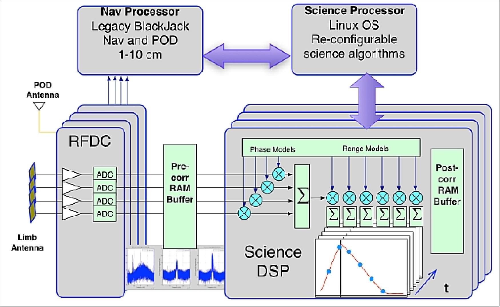
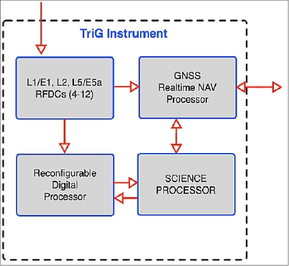
RFDC = RF-downconversion array
TGRS Performance Features: 54)
• Support for GPS CA, L1 and L2 Semi-Codeless, L2C, and L5
• Supports from 1 to 16 antennas
• Supports POD (Precision Orbit Determination), cm level positioning, mm/sec level velocity
• Supports RO (Radio Occultation) science for weather and climatology
• Supports Reflections science applications (in development).
The TGRS receiver requires more capable antennas than those flown on missions such as COSMIC. To maximize the number of ionospheric and atmospheric profiles, the TGRS receiver will be capable of tracking legacy and new GPS signals such as L5, L2C and L1C; GLONASS CDMA and Galileo E1 and E5a. 55)
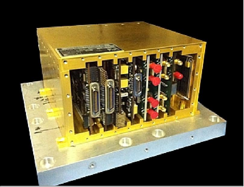
Navigation Processor Features | RO-Science Processor Features |
• PPC603r Processing Platform using RogueOS • 128 kB of System EEPROM (with TMR) • 1 GB of System NAND Flash (with TMR) • 256 MB of System SDRAM (with EDAC) • 384 MB of Sample SDRAM (no EDAC) • On-orbit Reconfigurable DSP FPGA • Spacecraft communication - 3 RS422 UARTs - 2 SpaceWire Ports - 4 RS422 pulse/s outputs, 1 LVDS pulse/s output • Ethernet interface for GSE communication during code development | •IBM750FX Processing Platform using Linux OS • 128 kB of System EEPROM (with TMR) • 1GB of System NAND Flash (with TMR) • 256 MB of System SDRAM (with EDAC) • 1GB of Buffer SDRAM (no EDAC) • Spacecraft communication - 3 RS422 UARTs - 2 SpaceWire Ports - 4 RS422 pulse/s outputs, 1 LVDS pulse/s output (generated by RO-Science DSP) • PCI interface for backplane communication with RO-Science DSP board • Ethernet interface for GSE communication during code development |
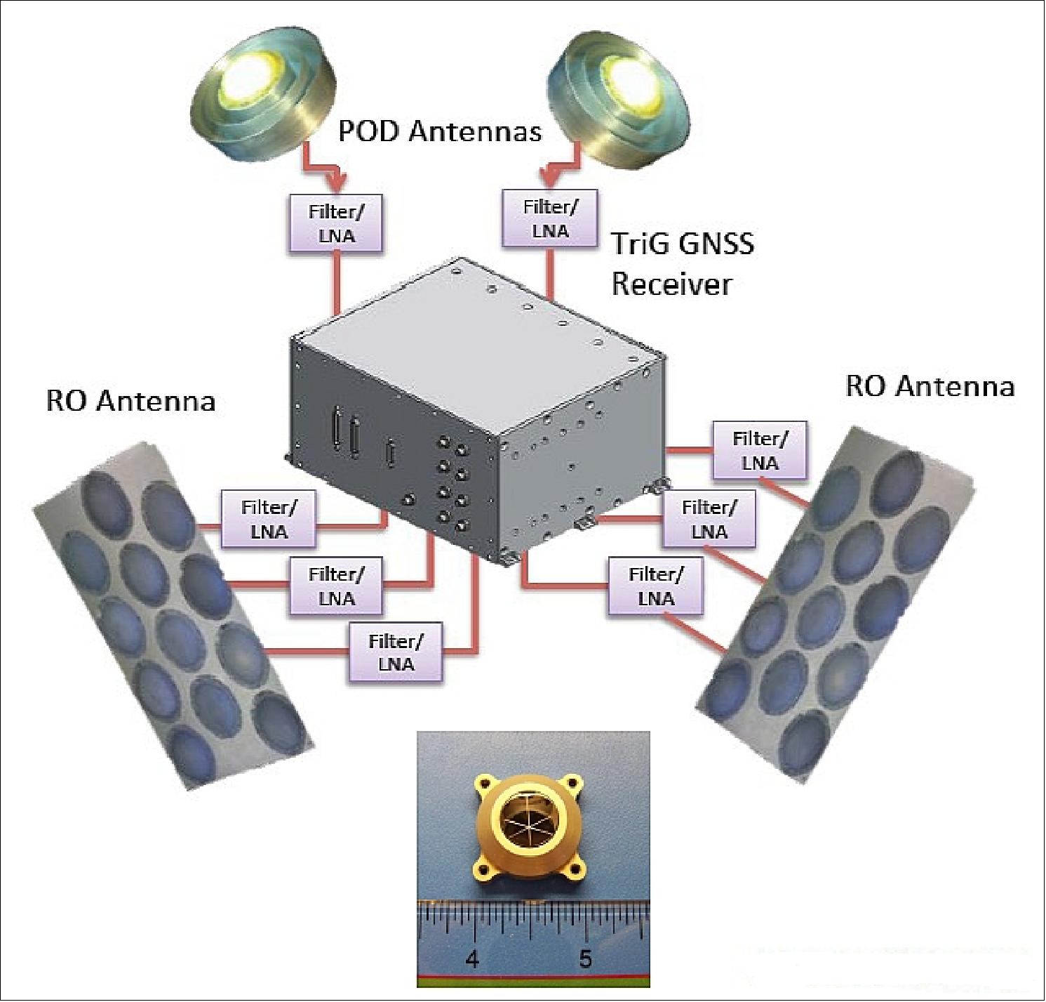
In 2013, Moog Broad Reach completed the TriG HW development in collaboration with NASA/JPL and has delivered the EM (Engineering Model) HW platform to Jet Propulsion Laboratory. 56)
3D Printed Antenna Arrays:
In 2014, RedEye, a Stratasys Company and leading provider of 3D printing services, partnered with NASA/JPL to 3D print 30 antenna array supports for the FormoSat-7 /COSMIC-2 satellite mission. This is the first time, 3D printed parts will function externally in outer space. The antenna arrays will capture atmospheric and ionospheric data to help improve weather prediction models and advance meteorological research on Earth. 57) 58)
A standard antenna array support design is traditionally machined out of astroquartz, an advanced composite material certified for outer space. Building custom antenna arrays out of astroquartz is time consuming and expensive because of overall manufacturing process costs (vacuum forming over a custom mold) and lack of adjustability (copper sheets are permanently glued between layers of astroquartz).
In order to keep the project on time and on budget, JPL needed an alternative method. They turned to RedEye to produce 3D printed parts that could handle the complex array designs and also be strong enough to withstand the demands of outer space. RedEye built the custom-designed parts using FDM (Fused Deposition Modeling) and durable ULTEM 9085 material, a thermoplastic that has similar strength to metals like aluminum but weighs much less.
Using FDM for a project like this has never been done before and it demonstrates how 3D printing is revolutionizing the manufacturing industry. While ULTEM 9085 has been well-vetted in the aerospace industry and is flammability rated by the FAA (Federal Aviation Administration), it has not previously been used or tested for an exterior application in space. Therefore, in addition to standard functional testing (i.e. antenna beam pattern, efficiency, and impedance match), FDM ULTEM 9085 and the parts had to go through further testing in order to meet NASA class B/B1 flight hardware requirements. Some of these tests included susceptibility to UV radiation, susceptibility to atomic oxygen, outgassing, thermal properties tests, vibration / acoustic loads standard to the launch rocket etc.
The ULTEM 9085's properties met all required qualification tests. To protect the antenna array supports against oxygen atoms and ultraviolet radiation, a layer of NASA's S13G protective paint was applied to the parts.
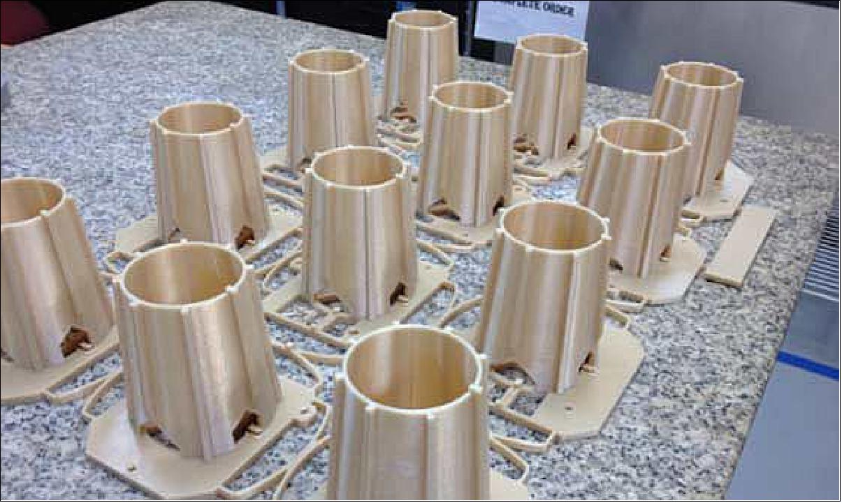
From March 2012 – April 2013, RedEye produced 30 antenna array structures for form, fit and function testing. As of 2014, RedEye was able to successfully enter the JPL Approved Supplier List and delivered 30 complete antennas for final testing and integration.
IVM (Ion Velocity Meter)
The USAF (U.S. Air Force) is partnering in FormoSat-7/COSMIC-2 and will provide two space weather payloads that will fly on the first six satellites: RF Beacon transmitters and IVM instruments.
IVM is a space weather instrument of AFRL (Air Force Research Laboratory), Kirtland AFB, Albuquerque, NM consisting of three packages: 59)
• IVM (Ion Velocity Meter) sensors, aperture plane and associated electronics
• SPLP (SSAEM Planar Langmuir Probe), sensors, aperture plane and associated electronics
• DCPU (Data Combiner/Power Unit) interface box.
In Feb. 2014, BATC (Ball Aerospace & Technologies Corp.) was awarded a contract from the Defense Weather System Directorate at the Space and Missile Systems Center in Los Angeles, Calif., for the production of the Ion Velocity Meter (IVM) under the U.S. Air Force Space Situational Awareness Environmental Monitoring program to fly aboard COSMIC-2.
The IVM instrument was originally designed by the University of Texas at Dallas (UTD). Ball Aerospace is under contract to build five replicas of the instrument under a firm fixed-priced contract. In addition to other operational space sensor programs, Ball Aerospace employs a disciplined technology transfer process to IVM based on prior collaboration with UTD on the National Polar-orbiting Operational Environmental Satellite System. 60)
The IVM instrument employs gridded electrostatic analyzers to observe and characterize the in-situ plasma. Key observables: in-situ ion density, temperature, & 3D drifts (E-fields).
All sensors are ram-facing. The IVM can measure the electric field perpendicular to the magnetic field and the ion motions parallel to the magnetic field through measurement of the ion drift velocity vector. Two sensors are part of the IVM package, the RPA (Retarding Potential Analyzer) and a DM (Drift Meter), which together provide data to determine the total ion concentration, the major ion composition, the ion temperature and the ion velocity in the spacecraft reference frame.
The SPLP is designed to measure absolute ion density, ion density fluctuations, and electron temperature. The SPLP has two independent sensor heads: an IT (Ion Trap) and a SP (Surface Probe). The Ion Trap is responsible for absolute ion density and density fluctuation measurements at sample rates up to 1 kHz for the identification of scintillating regions. The Surface Probe primarily measures electron temperature but also provides electron density, spacecraft potential and if necessary can perform the ion density fluctuation measurement. The power and data interface for IVM and SPLP is provided by the DCPU. It provides a single electronic interface between the spacecraft bus and the IVM sensors.
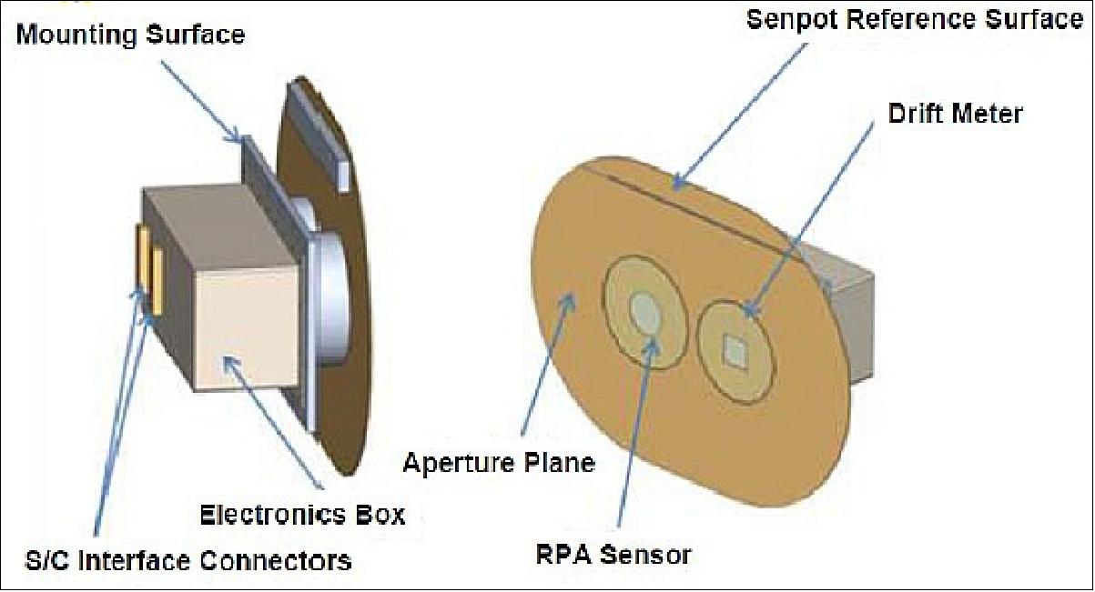
RF Beacon Instrument
The RF Beacon includes the sensor electronics and antenna. The RF Beacon will transmit a coherent signal at frequencies in the UHF, L-band and S-bands. Ground receivers will intercept the signals and derive information on ionospheric scintillation.
• The ITT antenna design is a cylinder of 25 cm in diameter and 29.1 cm tall.
• The SRI RF beacon antenna unit will be set of 3 nested quadrafilar helix antennae, with outermost and largest element (UHF) to be ~ 14 cm in diameter and 23 cm high, and mounted on a circular base plate/ground plane approximately 25 cm in diameter. The complete antenna unit has a volume of 25 cm x 25 cm x 35 cm.
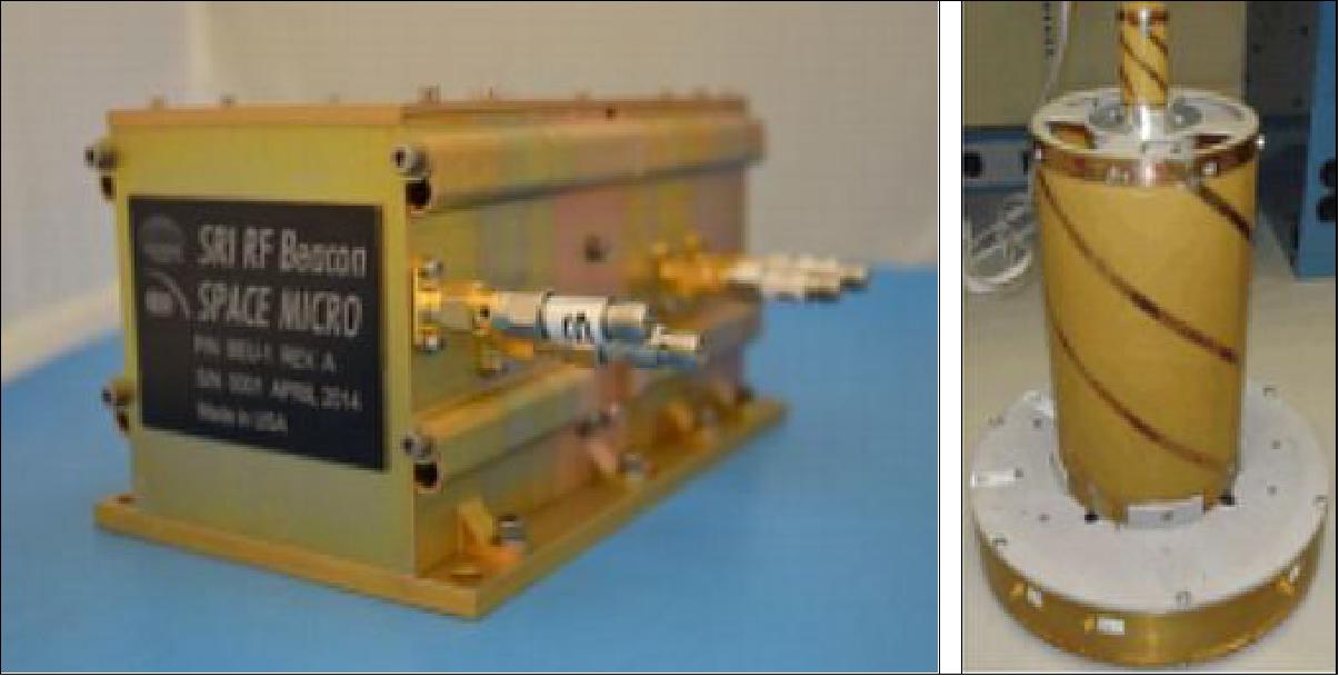

Ground Segment
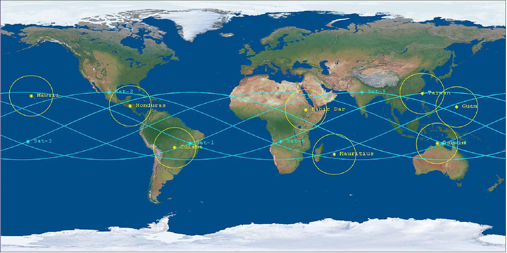
NSPO will fully utilize the current ground facility to accommodate the mission needs of FormoSat-7 including: 62)
• SOCC (Satellite Operations Control Center) to manage and conduct the FormoSat-7 mission operations
• Three existing S/S-band TT&C stations located in Chung-Li and Tainan to track and establish links with the spacecraft
• SOCC GCN (Ground Communications Network) to provide data transmission between SOCC and the external segments of RTS, Payload DPC, and Launch segment.
• With FY14 funding, NOAA is creating an initial ground architecture leveraging domestic and international partnerships (Ref. 18).
- Working with USAF to determine if existing Mark IVB sites can be utilized to support the COSMIC-2 mission
- USAF and NOAA working together to determine technical implementation and costs associated with implementation.
• International ground site collaboration:
- Taiwan ground site will be primary commanding
- Options for use of Australia’s (BOM) site infrastructure at Darwin still in discussion
- In cooperation with Brazil, their space agency (INPE) has procured a COSMIC-2 compatible antenna that will become part of the COSMIC-2 ground architecture.
Ground station location | Partner/Sponsor | Level of Commitment | Notes |
Taiwan | NSPO | 100% | Uses existing capability |
Cuiaba, Brazil | INPE | 100% | INPE awarded contract for GS in Jan 2014, MOU with NOAA in final coordination |
Darwin, Australia | BOM | ~90% | BOM and GeoScience Australia discussing path forward to provide dedicated support |
Mark IV-B – Hawaii | USAF | 100% | Working with USAF to establish compatibility with COSMIC-2 downlink |
Mark IV-B – Guam | USAF | 100% | Working with USAF to establish compatibility with COSMIC-2 downlink |
Mark IV-B – Honduras | USAF | 100% | Working with USAF to establish compatibility with COSMIC-2 downlink |
North Africa | Commercial Service | 0% | Subject of a FY15 solicitation for Data Services from commercial providers |
Mauritius* (TBD) | Commercial Service | 0% | Subject of a FY15 solicitation for Data Services from commercial providers |
References
1) Nick L. Yen, Chen-Joe Fong, Kendra L.B. Cook, Peter Wilczynski, “Future Low Earth Observation Satellite - Radio Occultation Mission,” 2011, URL: http://www.eumetsat.int/Home/Main
/AboutEUMETSAT/Publications/ConferenceandWorkshopProceedings/
2011/groups/cps/documents/document/pdf_conf_p59_s1_01_yen_v.pdf
2) Nick Yen, “FormoSat-7 /COSMIC-2 Joint Plan and Current Progress,” OPAC-2010 (Occultations for Probing Atmosphere and Climate-2010), Joint OPAC-4, GRAS-SAF & IROW-1 Climate Workshop, Graz, Austria, September 6-11, 2010 URL: http://www.uni-graz.at
/opac2010/pdf_presentation/opac_2010_yen_nick_presentation49.pdf
3) Dave Ector, Lidia Cucurull, Pete Wilczynski, “Plans for a 12 Satellite GNSS RO Constellation (COSMIC-2/FORMOSAT-7),” OPAC-2010 (Occultations for Probing Atmosphere and Climate-2010), Joint OPAC-4, GRAS-SAF & IROW-1 Climate Workshop, Graz, Austria, September 6-11, 2010 URL: http://www.uni-graz.at/opac2010/pdf_presentation/opac_2010_ector_dave_presentation08.pdf
4) “Status and Strategies for COSMIC-II Planning,” UCAR, Oct. 2008, URL: http://www.cosmic.ucar.edu/~kuo/Retreat-08/COSMIC-II-Planning.ppt
5) Kendra Cook, Peter Wilczynski, “COSMIC-2: Weather Forecasting and Space Weather Monitoring in the 21st Century,” earthzine, Oct. 13, 2010, URL: http://earthzine.org/2010/10/13/
cosmic-2-weather-forecasting-and-space-weather-monitoring-in-the-21st-century/
6) Dave Ector, “COSMIC-2 Update,” Nov. 4, 2010, URL: http://www.cosmic.ucar.edu/retreat_2010/presentations/Thu_Morning/COSMIC_2_Retreat_10.pptx
7) Kendra L. B. Cook, Peter Wilczynski, Chen-Joe Fong, Nick L. Yen, G. S. Chang, “The Constellation Observing System for Meteorology Ionosphere and Climate Follow-On Mission,” 2011 IEEE Aerospace Conference, Big Sky, MT, USA, March 5-12, 2011
8) Nick L. Yen, Chen-Joe Fong, Chung-Huei Chu, Jiun-Jih Miau, Yuei-An Liou, Ying-Hwa Kuo, “Global GNSS Radio Occultation Mission for Meteorology, Ionosphere & Climate,” URL: http://www.intechopen.com/download/pdf/pdfs_id/6844
9) Lidia Cucurull, Dave Ector, Estel Cardellach, “An overview of the COSMIC follow-on mission (COSMIC-II) and its potential for GNSS-R,” GNSS-R Workshop, Barcelona, Spain, October 21-22, 2010, URL: http://congress.cimne.com/gnss-r10/frontal/presentaciones/139.pdf
10) Bill Schreiner, C. Rocken, X. Yue, B. Kuo, P. Wilczynski, D. Ector, R. Fulton, “Follow‐On Radio Occulta0on Constella0ons for Meteorology, Ionosphere and Climate: Overview of Currently Planned Missions, Data Quality and Coverage, and Poten0al Science Applica0ons,” 2010 Space Weather Workshop, Boulder, CO, Apr 27‐30, 2010, URL: http://www.cosmic.ucar.edu
/groupAct/references/SWW-Apr30-2010-Schreiner.pdf
11) C.-J. Fong, D. Whiteley, E. Yang, K. Cook, V. Chu, B. Schreiner, D. Ector, P. Wilczynski, T.-Y. Liu, N. Yen, “Space and ground segment performance and lessons learned of the FORMOSAT-3/COSMIC mission: four years in orbit,” Atmospheric Measurement Techniques, 4, pp. 1115–1132, June 2011, URL: http://www.atmos-meas-tech.net/4/1115/2011/amt-4-1115-2011.pdf
12) http://www.nspo.org.tw/2011/tw/download/info/NSPO_EDM_2011.pdf
13) Bill Schreiner, C. Rocken, X. Yue, B. Kuo, D. Mamula, D. Ector, “GNSS Radio Occultation Constellations for Meteorology, Ionosphere and Climate: Status of the COSMIC and Planned COSMIC-2 Missions,” 2011 Space Weather Workshop, Boulder, CO, USA, April 26-29, 2011, URL: http://www.swpc.noaa.gov
/sww/SWW_2011_Presentations/Friday_830/SWW-Apr-2011-Schreiner.pdf
14) Nick L. Yen, Chen-Joe Fong, Kendra L. B. Cook, Peter Wilczynski, “Future Low Earth Observation Satellite - Radio Occultation Mission,” Proceedings of the 2011 EUMETSAT Meteorological Satellite Conference, 5-9 September 2011, Oslo, Norway, URL: http://www.eumetsat.int
/Home/Main/AboutEUMETSAT/Publications/ConferenceandWorkshopProceedings
/2011/groups/cps/documents/ document/pdf_conf_p59_s1_01_yen_v.pdf
15) Nick L. Yen, Chen-Joe Fong, G.-S. Chang, “Approaching the First Global Radio Occultation Operational Mission Using Constellation LEO Satellites,” Proceedings of the 2012 EUMETSAT Meteorological Satellite Conference, Sopot, Poland, Sept. 3-7, 2012, URL: http://www.eumetsat.int
/Home/Main/AboutEUMETSAT/Publications/ConferenceandWorkshopProceedings
/2012/groups/cps/documents/document/pdf_conf_p61_s1_08_yen_v.pdf
16) Chen-Joe Fong, Ming-Shong Chang, Nai-Chen Liu, Jer Ling, Ed. Stevens, Mark Taylor, James Nicholas, Padraig Quill, “Earth Observation Constellation Satellites Carrying Advanced Radio Occultation Receivers,” 2nd International Conference on GPS Radio Occultation (ICGPSRO), Taoyaun, Taiwan, May 14-16, 2013, URL: http://www.nspo.narl.org.tw/ICGPSRO2013/download/
2nd_ICGPSRO_U3-4A-102-02_Chen-Joe_Fong_05-16-2013.pdf
17) K. Cook, Chen-Joe Fong, M. J. Wenkel, P. Wilczynski, et al., “FORMOSAT-7/COSMIC-2 GNSS radio occultation constellation mission for global weather monitoring,” Proceedings of the IEEE Aerospace Conference, Big Sky, MT, USA, March 2-9, 2013
18) Kendra Cook, Peter Wilczynski , Mike Wenkel, Chen-Joe Fong, Vicky Chu, “The Future of GNSS-RO for Global Weather Monitoring and Prediction – A COSMIC-2 / FORMOSAT-7 Program Status Update,” Eighth FormoSat-3/COSMIC Data Users' Workshop,” Boulder, CO, USA, Sept. 30-Oct. 2, 2014, URL: http://www.cosmic.ucar.edu/workshop_2014/presentations/Session8/cook-session8.pdf
19) Chen-Joe Fong, Vicky Chu, Nick L. Yen, Jer Ling, Tiger J.-Y. Liu, G.-S. Chang, “FormoSat-7/COSMIC-2 Radio Occultation Mission: From Research to Operations,” International Radio Occultation Working Group (IROWG) 2nd Workshop, 28 March~3 April 2012, Estes Park, CO, USA, URL: http://www.irowg.org/docs/Presentation/fong.pdf
20) Jyh-Ching Juang, Yung-FuTsai, Chung-HueiChu, “On constellation design of multi-GNSS radio occultation mission,” Acta Astronautica, Vol. 82, Issue 1, January 2013, pp.88–94
21) I. T. Lee, H. F. Tsai, J. Y. Liu, C. H. Lin, T. Matsuo, L. C. Chang, “Modeling Impact of FORMOSAT-7 COSMIC-2 Mission on Ionosphere Monitoring,” Proceedings of C/NOFS Results and Equatorial Dynamics: A Technical Interchange Meeting, Albuquerque, NM, USA, 12-14 March 2013
22) Chung-Huei (Vicky) Chu, Guey-Shin Chang , Chen-Tsung Lin, Jer Ling, An-Ming Wu, “Introduction to FormoSat-7/COSMIC-2 Mission,” Proceedings of the 63rd IAC (International Astronautical Congress), Naples, Italy, Oct. 1-5, 2012, paper: IAC-12-B1.1.5
23) “FormoSat-7 Spacecraft Bus Contract Request For Proposal,” NSPO Solicitation No.: NSPO-P-100038, Oct. 25, 2011, URL: http://www.narl.org.tw/ext/po/po_attach.php?po_file_id=18044
24) Chen-Joe Fong, Nick L. Yen, Eddy Yang, Chung-Huei Chu, Jer Ling, Tiger Liu, Guey-Shin Chang, “Approaching the first GNSS operational radio occultation satellites mission carrying TriG receiver,” Sixth FORMOSAT-3/COSMIC Data Users' Workshop, Oct. 30 - Nov. 1, 2012, Boulder, CO, USA, URL: http://www.cosmic.ucar.edu/oct2012workshop/presentations/Session8/fong_session8.pdf
25) ”Taiwanese President Ma Ying-jeou views FORMOSAT-7 solar array testing,” SSTL, Dec. 14, 2015, URL: https://web.archive.org/web/20170610222857/http://www.sstl.co.uk/Blog/December-2015/Taiwanese-President-Ma-Ying-jeou-views-FORMOSAT-7
26) “SSTL delivers first of the FORMOSAT-7 constellation spacecraft to Taiwan,” SSTL, May 1, 2015, URL: https://www.sstl.co.uk/media-hub/latest-news/2015/sstl-delivers-first-formosat-7-spacecraft-to-taiwan
27) Nick L. Yen, “FORMOSAT-7/COSMIC-2 Progress Update and its Launch Plan,” 4th International Radio Occultation Working Group Workshop(IROWG), Melbourne, Australia, April 16-22, 2015, URL: http://irowg.org/wpcms/wp-content/uploads/2014/05/Yen-IROWG-4.pdf
28) Pete Wilczynski, “ COSMOC-2,” April 3, 2015, URL: http://irowg.org
/wpcms/wp-content/uploads/2014/05/Wilczynski-IROWG-4.pdf
29) “Spacecraft Bus Contract,” SSTL, Sept. 6, 2012, URL: https://web.archive.org/web/20170610193301/http://www.sstl.co.uk/Missions/FORMOSAT-7/FORMOSAT-7/Spacecraft-Bus-Contract
30) “SSTL to build up to twelve satellites for FORMOSAT-7’s global weather forecasting program,” January 28, 2013, URL: https://www.sstl.co.uk/media-hub/latest-news/2013/sstl-to-build-up-to-twelve-satellites-for-formosat-7%E2%80%99s-global-weather-forecasting-programme
31) Alex da Silva Curiel, Meryl Lambert, Doug Liddle, Martin Sweeting, Chung-Huei (Vicky) Chu, Chen-Joe Fong, Guey-Shin Chang, “Introduction to FORMOSAT-7/COSMIC-2 Mission,” Proceedings of the 27th AIAA/USU Conference, Small Satellite Constellations, Logan, Utah, USA, Aug. 10-15, 2013, paper: SSC13-VI-1, URL: http://digitalcommons.usu.edu/cgi/viewcontent.cgi?article=2948&context=smallsat , URL of presentation: http://digitalcommons.usu.edu/cgi/viewcontent.cgi?
filename=0&article=2948&context=smallsat&type=additional
32) Chen-Joe Fong, Ming-Shong Chang, Nai-Chen Liu, Jer Ling, Ed. Stevens, Mark Taylor, James Nicholas, Padraig Quill, “Earth Observation Constellation Satellites Carrying Advanced Radio Occultation Receivers,” 2nd International Conference on GPS Radio Occultation (ICGPSRO), Aspire Resort, Taoyaun, Taiwan, 14-16 May 2013, URL: http://www.nspo.narl.org.tw/ICGPSRO2013/
download/2nd_ICGPSRO_U3-4A-102-02_Chen-Joe_Fong_05-16-2013.pdf
33) “COM DEV to supply TT&C transponders for FORMOSAT-7,” ESA, Dec. 11, 2013, URL: http://telecom.esa.int/telecom/www/object/index.cfm?fobjectid=32766
34) Stephen Clark, ”Falcon Heavy launches on military-led rideshare mission, boat catches fairing,” Spaceflight Now, 25 June 2019, URL: https://spaceflightnow.com/2019/06/25/
falcon-heavy-launches-on-military-led-rideshare-mission-boat-catches-fairing/
35) ”Falcon Heavy STP-2 Launch Campaign Thread,” Reddit, 3 June 2019, URL: https://www.reddit.com/r/spacex/comments/bw6aa8/stp2_launch_campaign_thread/
36) ”STP-2 Mission,” SpaceX, URL: https://web.archive.org/web/20190924035352/https://www.spacex.com/stp-2
37) David Voelkel, Art Menichiello, Sabrina Herrin, Barbara Braun, Michael Marlow, ”The STP-2 Mission: Rideshare Lessons Learned from the Air Force’s First Falcon Heavy Launch,” Proceedings of the 34rd Annual AIAA/USU Virtual Conference on Small Satellites, August 1-6, 2020, Logan, UT, USA, paper: SSC20-VIII-03, URL: https://digitalcommons.usu.edu/cgi/viewcontent.cgi?article=4750&context=smallsat
38) “GPIM Spacecraft to Validate Use of 'Green' Propellant,” NASA, Aug. 19, 2014, URL: http://www.nasa.gov/content/gpim-spacecraft-to-validate-use-of-green-propellant/
39) ”U.S. and Taiwan cancel second set of COSMIC-2 satellites,” News Flash, October 19, 2017, URL: https://news.populiarno.com/2017/10/19/u-s-and-taiwan-cancel-second-set-of-cosmic-2-satellites/
40) ”Completion of Deployment for A Constellation of FORMOSAT-7 Satellites,” NSPO, 8 February 2021, URL: https://www.nspo.narl.org.tw/news_view.php?c=210326001&ln=en
41) Sean Healy, ”ECMWF starts assimilating COSMIC-2 data,” ECMWF Newsletter, No 163- Spring 2020, published in April 2020, URL: https://www.ecmwf.int/en/newsletter/163/news/ecmwf-starts-assimilating-cosmic-2-data
42) ”Data from the Formosat-7/COSMIC-2 constellation released,” SSTL, 12 March 2020, URL: https://www.sstl.co.uk/media-hub/
latest-news/2020/data-from-the-formosat-7-cosmic-2-constellation-re
43) ”STP-2 Mission,” SpaceX, 26 June 2019, URL: https://web.archive.org/web/20190627071249/https://www.spacex.com/news/2019/06/26/stp-2-mission
44) ”SSTL expertise enables new space mission for the FORMOSAT-7 weather constellation,” SSTL Press Release, 25 June 2019, URL: https://www.sstl.co.uk/media-hub/
latest-news/2019/sstl-expertise-enables-new-space-mission-for-the-f
45) Stephan Esterhuizen, Garth Franklin, Ken Hurst, Anthony Mannucci, Tom Meehan, Frank Webb, Larry Young, “TriG - A GNSS Precise Orbit and Radio Occultation Space Receiver,” URL: 22nd International Meeting of the Satellite Division of The Institute of Navigation (ION), Savannah, GA, USA, September 22-25, 2009, URL: http://authors.library.caltech.edu/21729/1/
Esterhuizen2009p12347Proceedings_Of_The_22Nd_International_Technical_Meeting_
Of_The_Satellite_Division_Of_The_Institute_Of_Navigation_(Ion_Gnss_2009).pdf
46) Paul R. Straus, “Ionospheric Aspects of COSMIC-2,” Eighth FormoSat-3/COSMIC Data Users' Workshop,” Boulder, CO, USA, Sept. 30-Oct. 2, 2014, URL: http://www.cosmic.ucar.edu/workshop_2014/presentations/Session8/strauss-session8.pdf
47) S. Esterhuizen, T. K. Meehan, D. Robison, J. Y. Tien, “TOGA - a GNSS Reflections Instrument for Remote Sensing Using Beamforming,”2009, URL: http://pythion.com
/old/papers/2009-esterhui-ieee-aero-toga.pdf
48) Jack Kaye, “NASA’s Global Environmental Remote Sensing Program,” Sixth FormoSat-3/COSMIC Data Users’ Workshop, Boulder, CO, USA, Oct. 30-Nov.1, 2012, URL: http://www.cosmic.ucar.edu/oct2012workshop/presentations/Session1/kaye/kaye_session1.pdf
49) Tom Meehan, Stephan Esterhuizen, Garth Franklin, Jeffrey Tien, Larry Young, Brian Bachman, Tim Munson, David Robison, Ted Stecheson, “Development Status of NASA's TriG GNSS Science Instrument,” IROWG-2 (International Radio Occultation Working Group), Workshop, Estes Park, CO, USA, March 28- April 3, 2012, URL: http://www.irowg.org/docs/Presentation/meehan.pdf
50) Tom Meehan, Stephan Esterhuizen, Garth Franklin, Jeff Tien, Larry Young, “Using NASA’s TriG Instrument for Space Weather, Weather and Climate,” OPAC-2010 (Occultations for Probing Atmosphere and Climate-2010), Joint OPAC-4, GRAS-SAF & IROW-1 Climate Workshop, Graz, Austria, September 6-11, 2010, URL:http://www.uni-graz.at/opac2010/
pdf_presentation/opac_2010_meehan_tom_presentation66.pdf
51) Bill Schreiner, Tom Meehan, Dave Ector, “Use of NASA’s TriG (Tri-GNSS) RO receiver as a GEOScan Hosted Sensor,” GEOScan Planning Workshop, Annapolis, MD, USA, Mar 27-30, 2011
52) T. K. Meehan, “The TriG Digital Beam Steered Sounder,” Proceedings of the 2009 IEEE Aerospace Conference, Big Sky, MT, USA, March 7-14, 2009
53) Jeffrey Y. Tien, Brian Bachman Okihiro, Stephan X. Esterhuizen, Garth W. Franklin, Thomas K. Meehan, Timothy N. Munson, David E. Robinson, Dmitry Turbiner, Lawarence E. Young, “TriG: Next Generation Scalable Spaceborne GNSS Receiver,” ION ITM 2012, Conference, January 30-February 1, 2012, Newport Beach, CA, USA, URL: http://trs-new.jpl.nasa.gov/dspace/bitstream/2014/42519/1/12-0537.pdf
54) “Broad Reach Delivers the TriG HW platform to NASA JPL,” Moog Broad Reach, 2013, URL: http://www.broadreachengineering.com/products/spaceborne-gps-receivers/
55) Dimitry Turbiner, Larry E. Young, Tom K. Meehan, “Phased Array GNSS Antenna for the FormoSat-7/Cosmic-2 Radio Occultation Mission,” 25th International Technical Meeting of the Satellite Division of The Institute of Navigation, Nashville, TN, USA, Sept. 17-21,2012
56) “Broad Reach Delivers the TriG HW platform to NASA JPL,” Moog Broad Reach, 2013, URL: http://www.broadreachengineering.com/products/spaceborne-gps-receivers/
57) “RedEye 3D prints 30 antenna arrays for NASA to function on the exterior of a satellite,” Nov. 21, 2014, URL: http://www.3ders.org/articles/
20141121-redeye-3d-prints-30-functional-antenna-arrays-for-nasa-cosmic-2-satellites.html
58) “Stratasys 3D Printing Keeps NASA Satellite On Time and On Budget – FDM Strong Enough for Space,” Stratasys, Feb. 12, 2015, URL: http://blog.stratasys.com/2015/02/12/nasa-3d-printing-fortus/
59) “FORMOSAT-7/COSMIC-2 Spacecraft Science Payloads to Spacecraft Bus Interface Requirement Document,” FS7-IRD-0002, Issue 00 , Revision 00, 2011/04/08
60) “Ball Aerospace Wins Air Force Contract for Ion Velocity Meter,” BATC, Feb. 12, 2014, URL: http://www.ballaerospace.com/page.jsp?page=30&id=568
61) Lidia Cucurull and GOSA (Global Observing System Analysis) Group, ”An Update on the COSMIC-2 mission,” Space Weather Workshop, Broomfield, CO, USA, 26-29, April 2016, URL: http://www.swpc.noaa.gov/sites/default/files/images/u33/Lidia-Space-Weather-workshop.pdf
62) Linton Chen, “FORMOSAT-7/COSMIC-2 Ground Segment and Data Processing,” May 16, 2013, URL: http://www.nspo.narl.org.tw/ICGPSRO2013/download/
2nd_ICGPSRO_U3-4A-102-03_Linton_Chen_05-16-2013.pdf
Spacecraft Launch Mission Status Sensor Complement Ground Segment References Back to top