TeLEOS-1 Commercial Imaging Satellite of Singapore
EO
Operational (nominal)
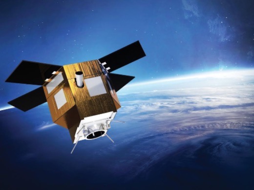
TeLEOS-1 is a commercial mission developed and operated by ST Electronics (STEE) in Singapore. It aims to provide convenient access to high temporal imagery to aid prompt response to time-sensitive events. Launched in December 2015 by the Indian Space Research Organisation (ISRO), it is the first commercial Earth observation satellite from Singapore.
Quick facts
Overview
| Mission type | EO |
| Mission status | Operational (nominal) |
| Launch date | 16 Dec 2015 |
Summary
Mission Capabilities
TeLEOS-1 is equipped with a day-only Electro-Optical (EO) payload. Its three imaging modes, Multi-Point, Strip and Area Imaging ensure optimisation for different application requirements.
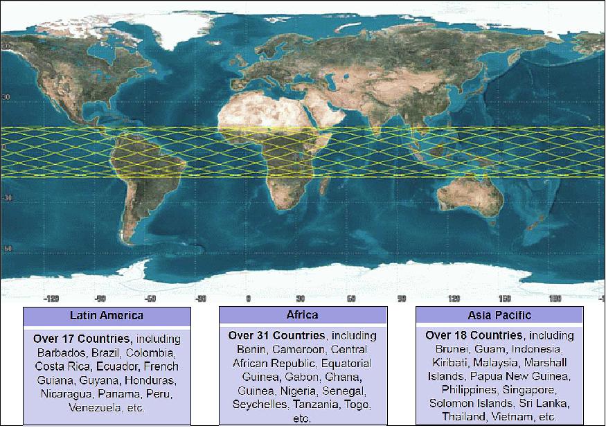
TeLEOS-1 is unique amongst other Earth observation satellites, providing greater responsiveness and data availability due to its low inclined orbit. This advantage is outset by forgoing the global coverage for an equatorial belt coverage.
Performance Specifications
It can perform six imaging passes over 24 hours, as opposed to two for traditional sun-synchronous orbiting satellites. TeLEOS-1 has a spatial resolution of 1 m at nadir, a swath width of 12 km, with a dynamic range of 10 bits and slew angles up to 45° from nadir.
TeLEOS-1 has an orbital inclination of 15°, and an orbital period of approximately 96 minutes at an altitude of 550 km. The satellite weighs 400 kg, measuring at 1.9 m x 2.0 m x 1.6 m in size. The mean revisit time is 12 to 16 hours.
Space and Hardware Components
For communications, an S-Band Telemetry Tracking and Control (TT&C) antenna system is used. It possesses an 8 GB solid-state recorder, transmitting data at up to 300 Mbit per second.
TeLEOS-1 also uses a Three Axis stabilised Attitude Determination and Control Subsystem (ADCS) to estimate and alter orientation when needed. Multiple ground stations are used to support the satellite.
TeLEOS-1 Commercial Imaging Satellite of Singapore
Spacecraft Launch Mission Status Sensor Complement References
TeLEOS-1 ("teleos" means "perfection" in Greek) is the first commercial Near Equatorial Orbit (NEqO) Earth Observation satellite of ST Electronics (STEE), Singapore. Operating at an altitude of 550 km, TeLEOS-1 offers 1 m high-resolution satellite imagery with an average revisit time of 12 to 16 hours. This will enable decision-makers and users convenient access to high temporal imagery and geospatial solutions to respond to time-sensitive events, such as homeland security and border control, maritime situation awareness, and disaster monitoring and management around the equatorial belt.
The minisatellite was developed by ST Electronics (Satellite Systems) Pte Ltd., (STEE-SatSys) Singapore. STEE-SatSys is a joint venture of STEE's wholly owned subsidiary, ST Electronics (Satcom & Sensor Systems) Pte Ltd (STEE - SatComS), NTU (Nanyang Technological University), Singapore, and DSO (Defence Science Organization) National Laboratories, Singapore. STEE-SatSys was set up in May 2011 to design, develop and deploy advanced Earth observation satellite systems, and to exploit and commercialize indigenous satellite engineering capabilities. 1) 2) 3) 4) 5) 6)
In February 2014, two independent suppliers of small and microsatellites – ATK Space Systems Inc. of Beltsville MD, USA and ST EE-SatComS entered into an agreement to jointly develop, manufacture and supply microsatellites and integration services to the world market. The two companies created a unique partnership to deliver cost-effective, turnkey space mission services with STEE-SatComS leading marketing efforts and promotion of the products in the Asia-Pacific region and ATK leading marketing efforts in the Americas, Europe and Middle East regions. 7)
Besides satellite manufacturing, STEE is active in satellite imaging services. STEE will continue to expand and establish its global network of data delivery and value–added geospatial services. Similarly, ATK brings its strengths in rocket propulsion and launch systems to the ATK-STEE relationship. Both are able to benefit from STEE's close collaboration with Singapore's CRISP (Center for Remote Imaging and Signal Processing) where the TeLEOS-1 ground control station is located. STEE and CRISP will also collaborate in value-added image exploitation works.
Spacecraft
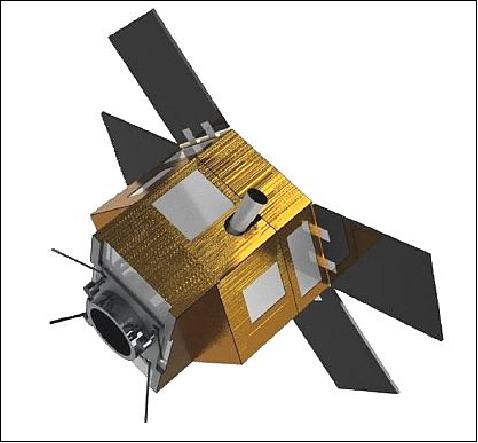
TeLEOS-1 differentiates itself from the world players of Earth Observation satellites in sun-synchronous orbits and yet complements them by providing high responsiveness and high availability data (mean revisit time of 12 to 16 hours) by nature of its low inclined orbit at 15º. This is achieved by foregoing global coverage for equatorial belt coverage. The equatorial belt covers many major shipping routes and natural disaster-prone regions. With a satellite mass of ~400 kg, TeLEOS-1 and its electro-optical payload are providing a panchromatic resolution of 1m (at nadir) based on STEE's own SS-400 bus. The spacecraft is very agile providing a slew angle of ±45º in all directions.
The spacecraft with a mass of ~400 kg features a fully redundant design with a design life of 5 years, a power generation of 680 W (EOL) and a size of 1.9 m x 2.0 m x 1.6 m (H) in a stowed configuration.
Satellite mass, power | About 400 kg, 680 W at EOL |
Satellite size (stowed) | 1.9 m x 2.0 m x 1.6 m (H) |
Communications, Onboard data storage | S-band TT&C data, 300 Mbit/s (X-band, CCSDS compliant), 8 GB solid state recorder |
ADCS (Attitude Determination and Control Subsystem) | 3-axis stabilized |
Mission control | Multiple ground station support |
Mean revisit time | 12 to 16 hours |
Availability | Up to 6 daylight imaging opportunities per day |
Spatial image resolution, data quantization | 1 m pan (nominal at nadir), 10 bit |
Swath width | 12 km @ nadir |
Max viewing angle, slew rate | ± 45º off-nadir nominal, 2.5º/s |
Mission design life | Fully redundant 5-year design life |
Launch
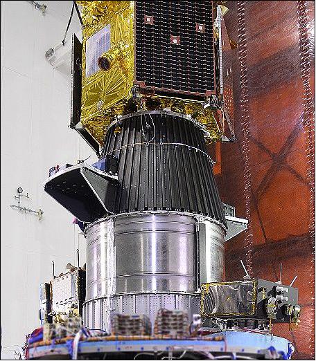
The TeLEOS-1 minisatellite was launched on December 16, 2015 (12:30:00 UTC) on a PSLV-C29 vehicle of ISRO from SDSC (Satish Dhawan Space Center) at Sriharikota on the east coast of India. 9) 10) 11) 12)
On Feb. 5, 2014, Antrix Corporation, the commercial arm of ISRO, signed a Launch Services Agreement with ST EE-SatComs, Singapore, for the launch of the TeLEOS-1 Earth Observation Satellite. 13)
The secondary payloads on this flight were:
• VELOX-CI, a minisatellite (123 kg) of NTU (Nanyang Technological University), Singapore.
• VELOX-II, a 13 kg 6U CubeSat of NTU, Singapore. A technology demonstration mission for intersatellite communication.
• Kent Ridge 1, a microsatellite (80 kg) of NUS (National University of Singapore) for Earth observation.
• Galassia, a nanosatellite (2U CubeSat, 2 kg) of NUS, Singapore with the objective to acquire TEC (Total Electron Count) data in the ionosphere.
• Athenoxat-1 (Athene Noctua Experimental Satellite), a 3U CubeSat (technology demonstration) of NTU, Singapore.
Orbit: NEqO (Near-Equatorial Orbit), altitude = 550 km, inclination = 15º, period =96 minutes.
The TeLEOS-1 mission differentiates itself from the world players of Earth Observation satellites in sun-synchronous orbits and yet complements them by providing high responsiveness and high availability data (mean revisit time of 12 to 16 hours) by nature of its low inclined orbit at 15°. This is achieved by foregoing global coverage for equatorial belt coverage. The equatorial belt covers many major shipping routes and natural disaster-prone regions.
Mission Status
• TeLEOS-1 and its payload are operating nominally in April 2017. 14)
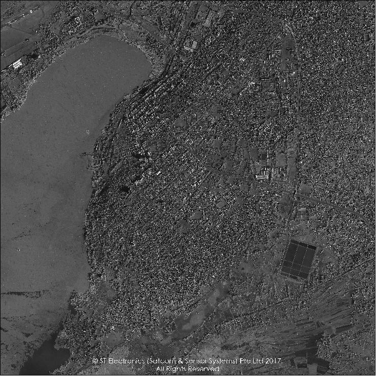
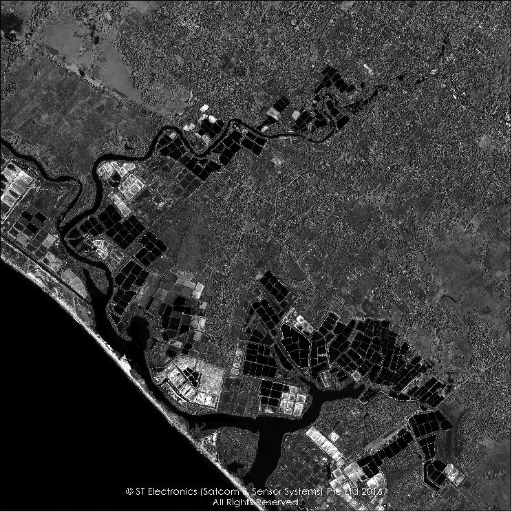
• July 26, 2016: STEE today announced the commencement of its commercial imagery service of the first made-in-Singapore commercial Earth observation satellite, TeLEOS-1, after an intensive IOT (In-Orbit-Test) since it was launched on 16 December 2015. This marks a significant milestone for ST EE as this is the world's first commercial imagery service providing one-meter resolution with the fastest response time from a Near-Equatorial Orbit remote sensing satellite. 15)
- "Today is a momentous milestone for ST Electronics as we launch TeLEOS-1's commercial imagery service. TeLEOS-1 has proven to perform well over an intensive six months IOT and we are happy to bring into service the world's first Near-Equatorial Orbit Earth observation satellite offering a 1 m resolution with unparalleled revisit time. Our unique offering of multi-source, multi-modal, high responsive satellite imagery has attracted strong interests from our international network of re-sellers and distributors. Our strategic partnership with DSTA (Defence Science & Technology Agency) and EDB (Economic Development Board) will strengthen the Space ecosystem in Singapore and bring it to greater heights," said Mr Lee Fook Sun, Deputy CEO & President, of Defence Business of ST Engineering and President of STEE.
- Through the vigorous six-month of IOT, STEE has successfully calibrated and validated the in-orbit performance of TeLEOS-1, covering the Attitude Determination Control System, On-Board Computing System, Flight Software, On-Board Network System, On-Board Recorder, Telemetry and Telecommand system, Payload Downlink system, Electrical Power system, Thermal Control System and Camera Payload. At the same time, the performance of the Ground Control Station was also successfully validated. The successful validations have paved the way for the launch of the imagery service of TeLEOS-1.
- With a mean revisit time of 12 to 16 hours and coverage of the equatorial belt with up to six daylight imaging opportunities a day, TeLEOS-1 is capable of providing down to 1 m resolution panchromatic imagery with a 12 km swath width. TeLEOS-1, being the first commercial remote sensing satellite operating in the Near Equatorial Orbit within ±15º around the equatorial belt, has the competitive advantage of having the fastest response time to react to urgent and ad-hoc imaging needs, shorter mean revisit time and higher imaging opportunities compared to the typical polar orbit remote sensing satellites over this region. Besides the sales of satellite imagery, STEE-SatComS will also provide value-added applications covering urban planning and infrastructure management for smart cities, environmental and resources monitoring, HADR (Humanitarian Aid and Disaster Relief), maritime security and safety, and border and territorial water protection.
• May 31, 2016: STEE-SatComS has launched their AgilSpace GeoPortal, a one-stop e-commerce hub for satellite imagery which will enable customers to place orders for new imagery to be captured or from its archive. "With the advent of big data analytics, we see great potential in the increasing pervasive use of high responsiveness and multi-source satellite imagery to meet diverse business, environmental and security needs in the market. AgilSpace GeoPortal will allow customers easy access to a wide array of satellite imagery in a timely, secure and effective manner to enable new applications to value-add to their operations," said Mr Tang Kum Chuen, President, STEE-SatComS. 16) 17)
Note: AgilSpace is the signature brand of STEE-SatComS to deliver satellite and Earth observation solutions and services to their customers worldwide.
- The AgilSpace GeoPortal from STEE-SatComS has a wide selection of imagery captured by TeLEOS-1. It will soon also contain imagery of its international imagery partners to deliver a multi-source, multi-modal mix of optical and radar satellite imagery. TeLEOS-1 was launched by STEE on Dec 16, 2015. The in-orbit test to calibrate the camera is in good progress.
- Meanwhile, a rich archive of satellite imagery has been accumulated and will be made available on the AgilSpace GeoPortal. The AgilSpace GeoPortal makes it easy for customers to place new imagery tasking orders, check the order status, and receive the imagery via FTP download. In addition, a unique feature of AgilSpace GeoPortal is its simulation engine for multi-satellite orbit predictions so that the customers can check for satellite passes over the area of interest, thereby allowing customers to book advanced imagery tasking orders.
• Feb. 16, 2016: First test images of the TeLEOS-1 mission were provided at the Singapore Airshow 2016. With a mean revisit time of 12-16 hours and coverage of the equatorial belt with up to 6 imaging opportunities within a day, TeLEOS-1 is capable of providing down to one-meter resolution panchromatic imagery, with a 12 km swath width. 18)
- TeLEOS-1, being the first remote sensing commercial satellite operating in the Near Equatorial Orbit at ± 15º inclination around the equatorial belt, has the competitive advantage of having more imaging opportunities compared to other polar orbit remote sensing satellites over this region. Business prospects for TeLEOS-1 include applications in maritime security and safety, Humanitarian Aid and Disaster Relief, environmental and resources monitoring and urban planning and infrastructure management. TeLEOS-1 remains on schedule to roll out its first commercial imagery by mid-2016.
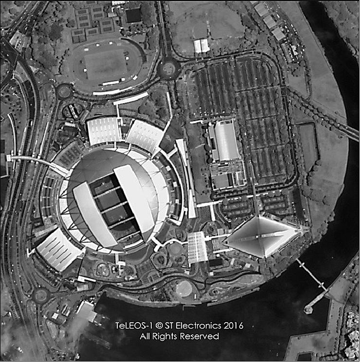
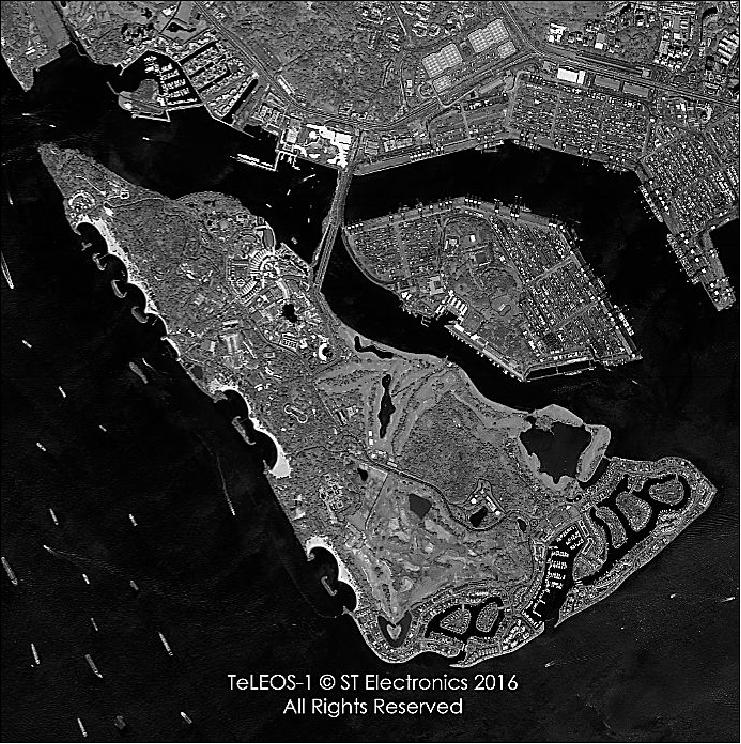
Legend to Figure 7: Sentosa Island has a size of ~ 5 km2. It lies just 0.5 km away from the southern coast of the main island of Singapore.
• First contact with TeLEOS-1 was made with the TeLEOS-1 ground station on 16 December, 1 hr and 48 minutes after launch. This is a pivotal milestone as it is an important step for the TeLEOS-1 Ground Control Station to establish communication with the satellite. With the link established, the team at the Ground Control Station can now receive the satellite's status reports as well as command the satellite to conduct all the planned IOT (In-Orbit Test) activities. The STEE engineering team is conducting the IOT for TeLEOS-1 which is expected to take about six months.
This includes: 19)
- Two weeks of the LEOP (Launch & Early Operations) phase – where the satellite status is being closely monitored during each ground pass (every 90 minutes, 24 hrs x 7) as various satellite bus subsystems will be powered on, deployed, and their responses checked to ensure the status is in defined order. TeLEOS-1 will exit the LEOP phase when the team assess that all basic satellite bus subsystems and their functions are running as expected.
- Two weeks of satellite bus calibration and validation – the performance of the various satellite bus subsystems is measured to determine what needs to be calibrated to improve their performance. For example, transmission power of the communication subsystems, or pointing accuracy of the ADCS (Attitude Determination and Control Subsystem).
- Five months of payload calibrations and experiments – this is to perform a series of imaging experiments for the camera payload, with different camera settings, at different areas (desert, forest, city, plantations, sea etc), and at various times of the day, to bring out the best performance of the camera.
Sensor Complement
TeLEOS-1 Imager
Imaging and collection specifications:
• Mean revisit time: 12 to 16 hours
• Resolution: 1m nominal at nadir
• Swath width: 12 km
• Data quantization: 10 bit
• Slew Rate: 2.5º/s and slew angles up to ±45º from nadir.

References
1) Peng Hwee Seah, "TeLEOS-1 for Environmental Monitoring," Singapore Space Symposium 2015, Sept. 30, 2015, NTU, Singapore, URL: http://www.sarc.eee.ntu.edu.sg/NewsnEvents/Documents/TeLEOS-1.pdf
2) "ST Electronics To Launch TeLEOS-1 The First Made-In-Singapore Commercial Remote Sensing Satellite," ST Electronics, Feb. 21, 2013, URL: http://www.stee.stengg.com/news/2013/02-03.html
3) "TeLEOS-1 Singapore 1st Commercial NEqO Earth Observation Satellite," AgilSpace, URL: http://www.agilspace.com/pdf/TeLEOS-1_Brochure.pdf
4) Leong Keong Kwoh, "Singapore Country Report," The 21th Session of the Asia-Pacific Regional Space Agency Forum, Tokyo, Japan, Dec. 4-5, 2014, URL: http://www.aprsaf.org/annual_meetings/aprsaf21/pdf/program/plenary/d3_1340_11_singapore.pdf
5) "TeLEOS-1 Singapore's First Commercial NEqO Earth Observation Satellite," URL: http://www.agilspace.com/pdf/TeLEOS-1_Brochure.pdf
6) Peng Hwee Seah, Tze Chung Maverick Tan, Robert H. Meurer, "TeLEOS-1in multi-source maritime security and safety applications," ACRS (Asian Conference on Remote Sensing, Nay Pyi Taw, Myanmar, Oct. 27-31, 2014, URL: http://a-a-r-s.org/acrs/administrator/components/com_jresearch/files/publications/OS-078%20TeLEOS-1%20in%20multi-source%20maritme%20security_ACRS2014_Final.pdf
7) Robert H. Meurer, Peng Hwee Seah, "Global Commerce in Small Satellite: Trends and New Business Models," Proceedings of the 28th Annual AIAA/USU Conference on Small Satellites, Logan, Utah, USA, August 2-7, 2014, paper: SCC14-I-2, URL: http://digitalcommons.usu.edu/cgi/viewcontent.cgi?article=3017&context=smallsat
8) Peng Hwee Seah, "TeLEOS-1 for Maintaining Safe and Green Environments," GSTC (Global Space & Technology Convention), Singapore, Feb. 11-13, 2015
9) Stephen Clark, "PSLV completes commercial launch with six Singaporean satellites," Spaceflight Now, Dec. 16, 2015, URL: https://spaceflightnow.com/2015/12/16/pslv-set-for-commercial-launch-with-six-singaporean-satellites/
10) "India's PSLV Rocket orbits six Satellite for Singapore in year-closing Mission," Spaceflight 101, Dec. 16, 2015, URL: http://spaceflight101.com/pslv-c29/indias-pslv-rocket-orbits-six-satellite-for-singapore/
11) "India to launch 6 Singaporean satellites," Space Daily, Dec. 11, 2015, URL: http://www.spacedaily.com/reports/India_to_launch_6_Singaporean_satellites_999.html
12) "Six Singapore-made satellites to blast into space," The Strait Times, Singapore, Oct. 22, 2015, URL: http://www.straitstimes.com/singapore/six-singapore-made-satellites-to-blast-into-space
13) "Antrix signs agreements for launching satellites from UK and Singapore on-board ISRO's workhorse Polar Satellite Launch Vehicle (PSLV)," ISRO, Feb. 6, 2014, URL: http://www.isro.org/scripts/news-6-2-14.aspx
14) Information provided by Wendy Ching Huifang of Singapore Technologies Electronics Limited.
15) "ST Electronics Launches New Service with Successful Completion of In-Orbit Test of TeLEOS-1," ST Electronics Press Release, July 26, 2016, URL: http://www.stengg.com/press-centre/press-releases/st-electronics-launches-new-service-with-successful-completion-of-in-orbit-test-of-teleos-1
16) "On The Show Floor... ST Electronics Exhibits Their New AgilSpace GeoPortal @ CommunicAsia2016," Satnews Daily, May 31,2016, URL: http://www.satnews.com/story.php?number=1487084706
17) CommunicAsia2016, The 27th International Communications and Information Technology Exhibition & Conference, May 31- June 3, 2016,
18) "ST Electronics Showcases AgilSpace™ Solutions at Singapore Airshow 2016," Feb. 16, 2016, URL: http://www.stee.stengg.com/news/2016/02-02.html and PDF file, URL: http://www.stee.stengg.com/news/2016/02-02.pdf
19) "Launch of ST Electronics's TeLEOS-1 Assists w/Security + Safety," SatNews Daily, Dec. 17, 2015, URL: http://www.satnews.com/story.php?number=372960193
The information compiled and edited in this article was provided by Herbert J. Kramer from his documentation of: "Observation of the Earth and Its Environment: Survey of Missions and Sensors" (Springer Verlag) as well as many other sources after the publication of the 4th edition in 2002. - Comments and corrections to this article are always welcome for further updates (eoportal@symbios.space).
Spacecraft Launch Mission Status Sensor Complement References Back to top