TEMPO (Tropospheric Emissions: Monitoring of Pollution)
EO
Atmosphere
NASA
Atmospheric chemistry
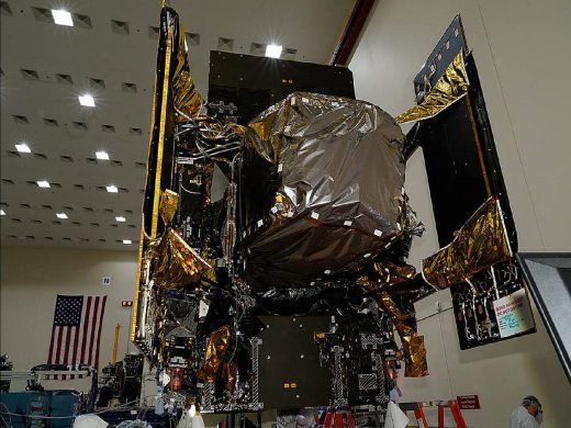
Launched on 7 April 2023 as a payload onboard the commercial Intelsat 40e (IS40e) communications satellite, Tropospheric Emissions: Monitoring of Pollutants (TEMPO), is a spaceborne instrument mission, owned and operated by NASA (National Aeronautics and Space Administration). TEMPO aims to monitor major air pollutants over the North American continent from a geostationary satellite.
Quick facts
Overview
| Mission type | EO |
| Agency | NASA |
| Mission status | Commissioning |
| Launch date | 07 Apr 2023 |
| Measurement domain | Atmosphere |
| Measurement category | Ozone, Trace gases (excluding ozone) |
| Measurement detailed | O3 Mole Fraction, NO2 Mole Fraction, HCHO Mole Fraction |
| Instruments | Spectrometer (TEMPO) |
| Instrument type | Atmospheric chemistry |
| CEOS EO Handbook | See TEMPO (Tropospheric Emissions: Monitoring of Pollution) summary |
Summary
Mission Capabilities
The TEMPO mission is a single instrument, to be hosted onboard a host spacecraft. TEMPO is an imaging Offner grating spectrometer that measures solar backscattered Earth radiance, to determine Ozone Mole Fraction, Formaldehyde Mole Fraction and Nitrogen Dioxide Mole Fraction. Due to the high spatial and temporal resolution of the spectrometer, TEMPO data will improve emission inventories, monitor population exposure to pollution, and make it possible for regulatory agencies to implement effective emission control strategies.
Performance Specifications
TEMPO has dimensions 1.4 x 1.1 x 1.2 m , with a mass of 148 kg. It captures data with a Field of Regard (FOR) of 4.76º N/S x 8.95º E/W, a GSD (Ground Sample Distance) of 2.21 x 4.97 km and a spectral range of 290 - 490 nm, 540 - 740 nm (ultraviolet and visible range). TEMPO has a spectral resolution of 0.57 nm, with images taken at hourly intervals.
Carried onboard the IS40e satellite as an additional payload, TEMPO will operate in a geostationary orbit of 35 786 km, at a planned position of 91° West, above the equator.
Space and Hardware Components
The TEMPO ground segment consists of the IOC (Instrument Operations Centre) and the interface to the host SOC (Spacecraft Operations Centre). The ground segment controls the instrument, monitors instrument health and status, and produces data for delivery to the SDPC (Science Data Processing Centre). The SPDC receives and processes instrument data to generate science products, and is responsible for the distribution of processed data products.
TEMPO (Tropospheric Emissions: Monitoring of Pollution)
Mission Status Launch Instrument Ground Segment References
TEMPO is a spaceborne instrument mission which was selected in November 2012 through NASA’s first EVI (Earth Venture Instrument) solicitation. NASA's EVI is part of the agency’s ESSP (Earth System Science Pathfinder) program. The goal of the TEMPO mission is to monitor major air pollutants from geostationary orbit across the North American continent hourly during daytime. The competitively selected TEMPO proposal is led by Kelly Chance of Harvard-Smithsonian/CfA (Center for Astrophysics), Cambridge, MA, USA. The instrument will be developed at BATC (Ball Aerospace and Technologies Corporation), the project management is provided by NASA/LaRC. Other collaborative institutions are: NASA/GSFC, NOAA, EPA, NCAR, Harvard, UC Berkeley, St. Louis University, University of Alabama, Huntsville, and the University of Nebraska. International collaboration is provided by KARI and NIER (Korea), ESA (European Space Agency), and Canada. 1) 2) 3) 4)
As PI (Principal Investigator), Kelly Chance SAO (Smithsonian Astrophysical Observatory) is responsible for developing an instrument that will measure major air pollutants over Greater North America, from Mexico City to the Canadian tar sands, and from the Atlantic to the Pacific, every daylight hour. The measurements will be taken from geostationary orbit, which will enable continuous data collection over this region. A unique aspect of this mission is that the instrument will be a hosted payload flown on a commercial geostationary satellite. TEMPO will be the North American geostationary component of an international constellation for air quality monitoring. 5) 6) 7)
The TEMPO mission builds on the science team’s experience with the European GOME (Global Ozone Monitoring Experiment) and SCIAMACHY (Scanning Imaging Absorption Spectrometer for Atmospheric Cartography) missions and with the OMI (Ozone Monitoring Instrument) flying on NASA’s Aura spacecraft. All of these missions measure atmospheric pollution from a sun-synchronous polar orbit. If the projected 2018-2019 launch timeframe holds for TEMPO, its observations should coincide with measurements from Europe’s Sentinel-4 mission, planned for launch in 2019, and Korea’s GeoKOMPSAT-2B (Geostationary Korea Multi-Purpose Satellite-2B), planned for launch in 2019. The Sentinel-4 mission will consist of an UVNS (Ultraviolet-Visible-Near-Infrared Spectrometer), a sounder accommodated on MTG-S (Meteosat Third Generation Sounder) platforms of EUMETSAT. All three missions will have similar geostationary orbits and similar air quality observation objectives. The three satellites will comprise a constellation for observing continental air quality and estimating transcontinental transport of pollution across the Atlantic and Pacific oceans. 8) 9) 10) 11)
Instrument | Detectors | Spectral coverage | Spectral resolution | Ground pixel size, km | Global coverage |
GOME (1995-2011) | Linear arrays | 240-790 nm | 0.2-0.4 nm | 40 x 320 (40 x 80 zoom) | 3 days |
SCIAMACHY | Linear arrays | 240-2380 nm | 0.2-1.5 nm | 30 x 30/60/90 | 6 days |
OMI (2004) | 2D CCD | 270-500 nm | 0.42-0.63 nm | 15 x 30 - 42 x 162 | daily |
GOME-2a,b (2006, 2012) | Linear arrays | 240.790 nm | 0.24-0.53 nm | 40 x 40 | near-daily |
OMPS-1 (2011) | 2D CCDs | 250-380 nm | 0.42-1.0 nm | 50 x 50 250 x 250 | daily |
Alignment with 2007 Decadal Survey
The NRC 2007 Decadal Survey “Earth Science and Applications from Space: National Imperatives for the Next Decade and Beyond” recommended missions including GEO-CAPE (Geostationary Coastal and Air Pollution Events). The atmosphere part of GEO-CAPE is recommended to include the measurements proposed here .
TEMPO makes all the requisite GEO-CAPE UV/visible measurements, including O3, NO2, H2CO, and aerosols (plus several additional species including SO2). Together with the proposed IR instrument for CO measurements, all GEO-CAPE atmospheric requirements for North America are fulfilled.
Science Objectives
The TEMPO science objectives result from many years of experience with requirements developed by the air quality community, using observations of pollution from sun-synchronous, polar orbits. TEMPO’s advanced capabilities over heritage instruments are designed to answer the following science questions:
1) What are the temporal and spatial variations of emissions of gases and aerosols important for air quality and climate?
2) How do physical, chemical, and dynamical processes determine tropospheric composition and air quality over spatial scales ranging from urban to continental, and temporally from diurnal to seasonal?
3) How does air pollution drive climate forcing, and how does climate change affect air quality on a continental scale?
4) How can observations from space improve air quality forecasts and assessments for societal benefit?
5) How does intercontinental pollution transport affect air quality?
6) How do episodic events (e.g., wild fires, dust outbreaks, and volcanic eruptions) affect atmospheric composition and air quality?
Each of these questions has been explored from polar orbit using data from OMI onboard Aura of NASA, SCIAMACHY on the Envisat mission of ESA, and the GOME instruments flown on EUMETSAT missions. These instruments have surveyed key atmospheric constituents that relate to air pollution and quality and include tropospheric and stratospheric ozone (O3), which in the troposphere is a pollutant and a greenhouse gas; sulfur dioxide (SO2); formaldehyde (H2CO); nitrogen dioxide (NO2); glyoxal (C2H2O2); water vapor; cloud properties; aerosol characteristics, including AOD (Aerosol Optical Depth); and UV-B radiation. TEMPO will also measure the same atmospheric constituents, but from geostationary orbit, thereby allowing better spatial and temporal resolutions. 12) 13)
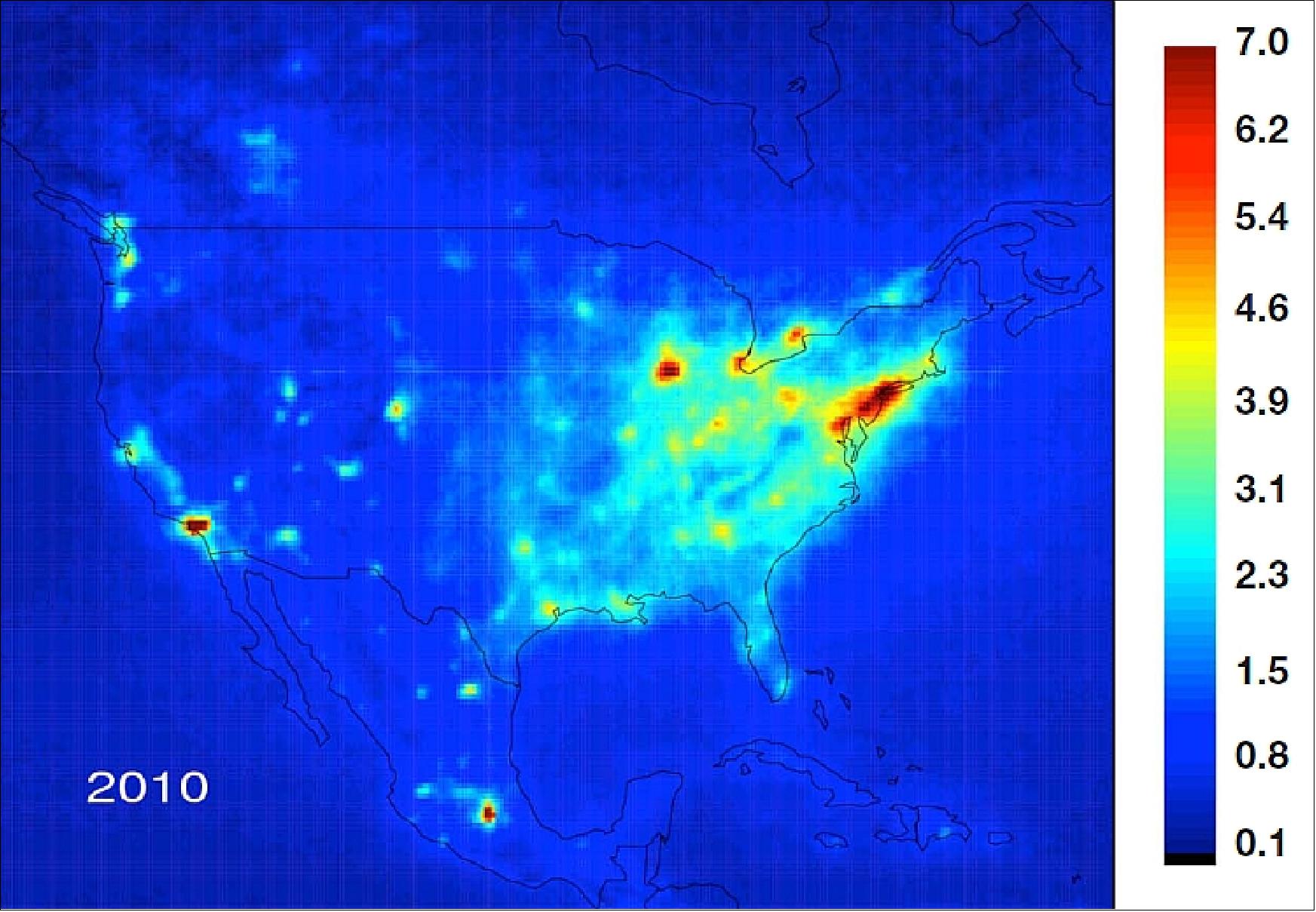
The heritage satellite data have revealed how air quality changes from day-to-day and year-to-year. They have shown improvements in air quality over North America because of regulation of power plant and automobile emissions, and also have tracked recent severe pollution events originating over urban locations from Asia to North America. These observations have more recently shown the degradation of air quality with high amounts of pollution over the Canadian tar-sand oil excavation fields. An example of NO2 data collected from OMI over the course of a year is shown in Figure 1. These data show urban and industrial hot spots that typically result from auto emissions and power plants.
The TEMPO mission’s key capabilities are:
• Geostationary location at 100° W longitude—proposed to cover Greater North America.
• Planned data latency is two hours (near real-time) for air quality products developed with the EPA and NOAA.
• A two-year operations (Phase-E) period, driven by the cost cap. The instrument life-time — allowing extended operations — is much greater.
TEMPO will observe the components of pollution and their source gases over all major cities and industrial areas in Greater North America. EPA (Environmental Protection Agency) has designated O3, SO2, NO2, and aerosols as criteria pollutants, and are recognized to be harmful to health and the environment and cause property damage. Major proxies for air pollution include formaldehyde and glyoxal in the atmosphere, indicating the presence of non-methane volatile organic compounds (NMVOC) emissions. The short lifetime of NMVOCs make them ideal for locating the source of emissions from natural and anthropogenic processes, including biomass burning. Figure 2 illustrates the TEMPO instrument’s FOR for a one-hour measurement cycle.
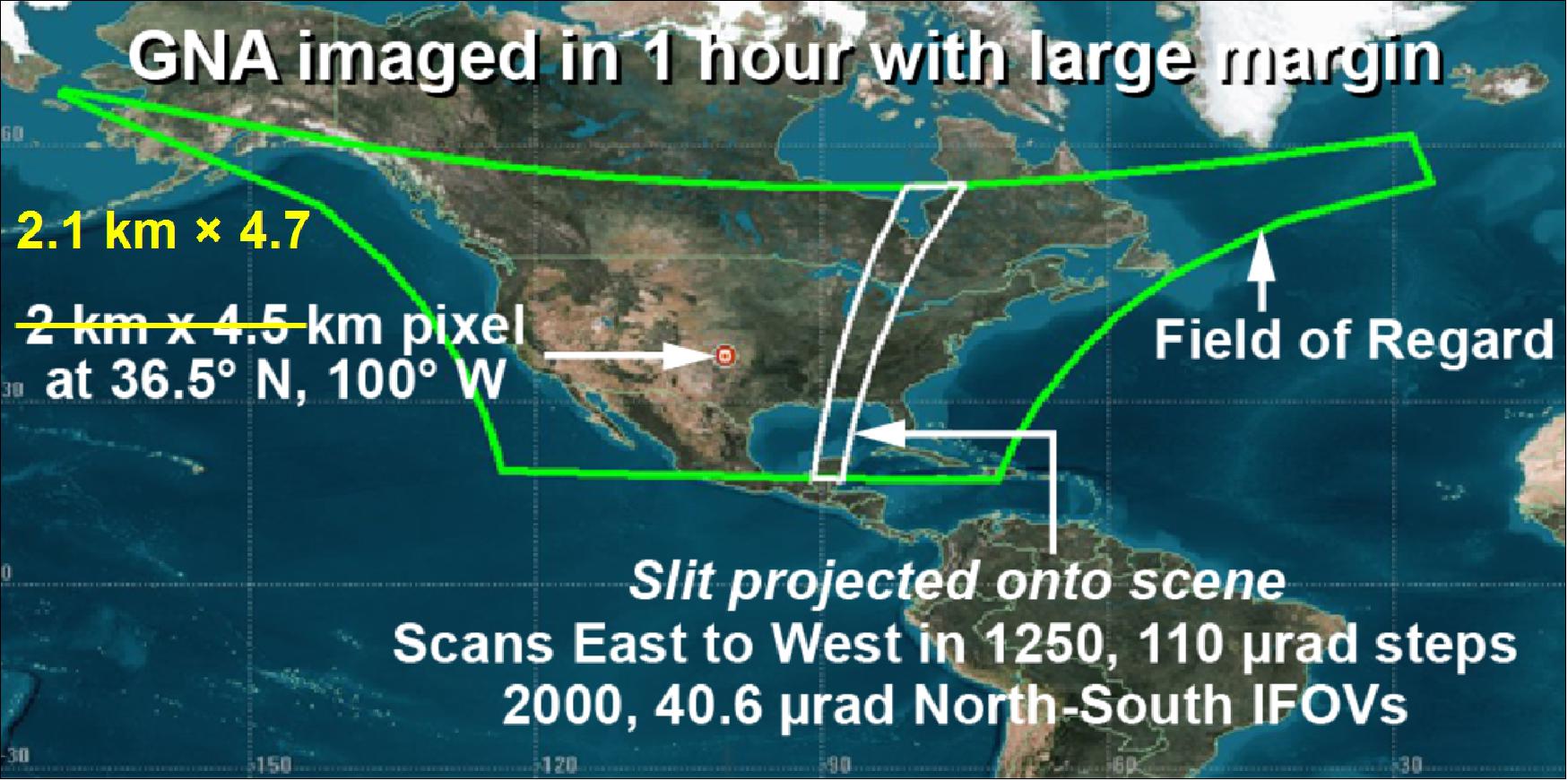
Legend to Figure 2: TEMPO’s FOR is outlined in green over GNA (Greater North America). The spread with increasing latitude is due to the projection of the FOR as seen from a geostationary orbit where the satellite is over the equator. The narrow white band is an exaggeration of TEMPO’s field of view,nominally 4.7 km, which scans from east to west over the course of an hour. The coverage from south to north will include the range from Mexico City to the Canadian tar sands.
TEMPO is a low risk mission with significant space heritage:
• All proposed TEMPO measurements have been made from LEO (Low Earth Orbit) satellite instruments to the required precisions
- NASA TOMS-type O3
- SO2, NO2, H2CO, C2H2O2 from AMF (Air Mass Factor)-normalized cross sections
- Absorbing Aerosol Index, UV aerosol, Rotational Raman scattering cloud, UV index eXceL profile O3 for selected geographic targets.
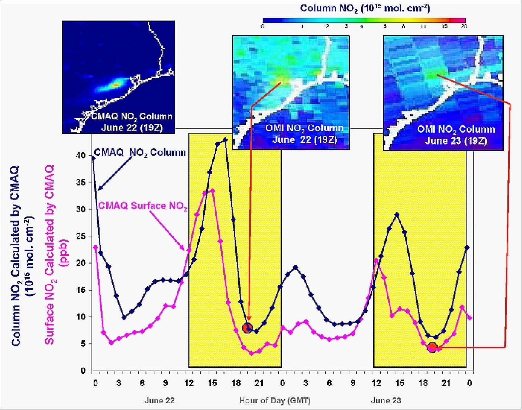
An example of the TEMPO temporal capability is shown in Figure 3. The figure depicts a CMAQ (Community Multi-scale Air Quality) model calculation of column amounts of NO2 over the course of two days based on emissions, photochemistry, and the local meteorology. Two observations from OMI over the same location are also indicated, illustrating the limitations of a polar-orbiting satellite for observing evolving time-of-day processes. The TEMPO observational period shown will be similar to the model calculations, but limited to daytime and cloud-free scenes. TEMPO’s near-continuous observations will be superior to polar orbiting satellite data for verifying model predictions and likely observe features not seen in the model. It is also anticipated that data in the boundary layer will be significantly improved with TEMPO’s higher spatial resolution, which is made possible by longer integration times from geostationary orbit.
Mission organization: TEMPO consists of the Instrument Project, competitively selected by NASA from the SAO proposal, and the Mission Project, directed to the NASA/LaRC (Langley Research Center). The SAO Principal Investigator, Kelly Chance, has delegated Project Management, Systems Engineering, Safety and Mission Assurance, and management of the BATC prime contract to LaRC, led by Project Manager Wendy Pennington. The Mission Project provides the spacecraft, a commercial geostationary communications satellite host, integration, launch, and provision of telemetry data to the SAO. The host selection will occur once the instrument is completed in 2017. The TEMPO Ground System, including the Instrument Operations Center and the Science Data Processing Center are at the SAO. Data distribution will include the RSIG (Remote Sensing Information Gateway) of EPA (Environmental Protection Agency).
Strategic communication, public engagement, and student collaboration: TEMPO includes a program of activities led by the SAO, and a synergistic effort at LaRC that involves students from Minority Serving Institutions in pursuing TEMPO-related research:
• Enhance interest in and public awareness of NASA’s efforts to measure the distribution and temporal variation of air pollution across North America, and, specifically, the story of the TEMPO mission and its components (instrument, technology, team).
• Promote science literacy by using the TEMPO story to communicate the links between basic chemistry, physics, and geoscience concepts, and issues of human health and well-being.
• Empower students, citizen scientists and science communication professionals - including formal and informal educators - in using TEMPO data products to support authentic science engagement.
• Engage a diverse network of students and universities in contributing to TEMPO experimental validation and NASA air quality research.
The activities planned to accomplish these goals include the public-oriented website http://tempo.si.edu/ ; news and social media activities; the development of a mobile app and user-friendly TEMPO data interfaces (e.g., RSIG) to enable citizen science and broader general use of pollution data; collaborations with STEM (Science Technology Engineering Mathematics) education partners such as the Smithsonian Institution, the GLOBE project and My NASA DATA; public engagement events and programs at museums, anchored by a network of ozone gardens; and summer internships and research experiences for students and educators at LaRC.
Mission Status
• April 7 2023: NASA’s TEMPO launched from Cape Canaveral Space Force Station in Florida atop a SpaceX Falcon 9 rocket, on its way to geostationary orbit at 00:30 EDT. The instrument is a payload on the satellite Intelsat 40E, which separated from the rocket approximately 32 minutes after launch. Signal acquisition occurred at 1:14 a.m. TEMPO commissioning activities will begin in late May or early June. The Tropospheric Emissions: Monitoring of Pollution (TEMPO) instrument will improve life on Earth by revolutionising the way scientists observe air quality from space. 34)
• July 5, 2022: On June 30, crews successfully completed the first fully integrated powered testing of the Tropospheric Emissions: Monitoring of Pollution (TEMPO), instrument on Intelsat IS40e at Maxar Technologies' satellite manufacturing facility in Palo Alto, California. This testing marks the completion of the TEMPO Instrument integration with the IS40e satellite. 15)
- From its geostationary orbit — a high Earth orbit that allows satellites to match Earth's rotation — TEMPO will take hourly daytime air quality observations at an unprecedented spatial resolution. Its measurements will reach from Puerto Rico and Mexico to northern Canada, and from the Atlantic to the Pacific, encompassing the entire lower 48 United States.
- "The completion of TEMPO Instrument integration with its host satellite will allow Intelsat IS40e to transition into environmental testing, which brings us one significant and exciting step closer to launch," said Kevin Daugherty, TEMPO project manager at NASA's Langley Research Center in Hampton, Virginia.
- Environmental testing will include thermal vacuum, dynamics and electromagnetic interference/electromagnetic compatibility. These tests will ensure the spacecraft will successfully endure conditions it will be exposed to during launch and in the harsh environment of space. TEMPO is currently targeted to launch aboard a SpaceX Falcon-9 rocket in January 2023.
- From its geostationary orbit TEMPO will also form part of an air quality satellite "virtual constellation" that will track pollution around the Northern Hemisphere.
- Kelly Chance, of the Center for Astrophysics | Harvard & Smithsonian in Cambridge, Massachusetts, is the principal investigator for TEMPO. Ball Aerospace built the TEMPO instrument.

• December 1, 2021: An air quality sensor that will dramatically improve the way scientists measure air pollution over North America has been joined with its satellite host. 16)
- NASA's TEMPO (Tropospheric Emissions: Monitoring of Pollution) instrument was integrated with Intelsat 40e by Maxar's Space Program Delivery team in Palo Alto, California. From its geostationary orbit — a high Earth orbit that allows satellites to match Earth's rotation — TEMPO will take hourly daytime observations of air quality over an area that extends from Puerto Rico to northern Canada, from the Atlantic to the Pacific, encompassing the entire continental United States.
- "Because of the hard work and dedication of the entire TEMPO team including our Maxar, Intelsat, and Ball Aerospace partners, we are excited to have completed this significant step toward launching with the IS40e spacecraft " said Kevin Daugherty, TEMPO project manager at NASA's Langley Research Center in Hampton, Virginia. "We are looking forward to completing the instrument integration and spacecraft testing in the coming months bringing us closer to delivery of TEMPO's critical air quality science."
- Air pollution — including ozone, nitrogen dioxide and formaldehyde, and tiny atmospheric particles called aerosols — can have serious consequences for human health and the environment.
- Currently scheduled to launch in 2022, TEMPO will also form part of an air quality satellite "virtual constellation" that will offer a more holistic view of how pollution is transported around the Northern Hemisphere. Ball Aerospace in Broomfield, Colorado built the TEMPO instrument.
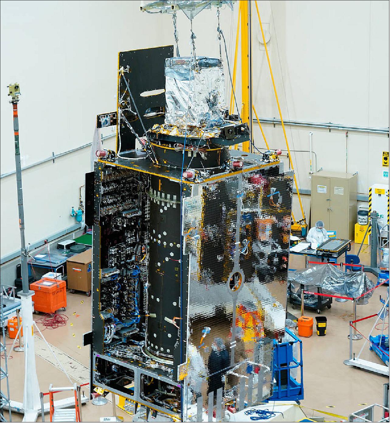
• May 21, 2021: A NASA satellite instrument that will measure air pollution over North America has reached another key project milestone. On Tuesday, May 18, The Tropospheric Emissions: Monitoring of Pollution (TEMPO), instrument, which will take hourly daytime measurements at an unprecedented spatial resolution shipped from Ball Aerospace in Broomfield, Colorado, to Maxar Technologies' satellite manufacturing facility in Palo Alto, California, for integration onto the Intelsat 40e. 17)
- Ball completed building TEMPO in 2018. After its scheduled launch in 2022, the TEMPO instrument will make measurements of air pollution —including ozone, nitrogen dioxide and formaldehyde, and tiny atmospheric particles called aerosols — that can damage human health and the environment. Those measurements will reach from Puerto Rico and Mexico to northern Canada, and from the Atlantic to the Pacific, encompassing the entire lower 48 United States.
- "This is an exciting time for the mission," said Kevin Daugherty, TEMPO project manager at NASA's Langley Research Center in Hampton, Virginia. "We are about to begin integrating the TEMPO instrument with our host satellite and undergo testing to ensure the satellite can survive the launch and environment of space prior to being launched into space."
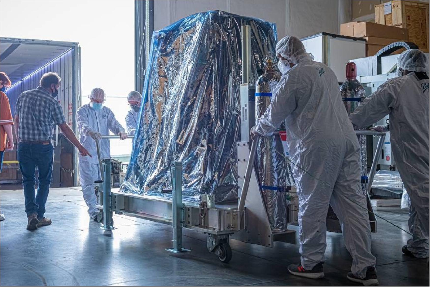
- From its geostationary orbit — a high Earth orbit that allows satellites to match Earth's rotation — TEMPO will also form part of an air quality satellite "virtual constellation" that will track pollution around the Northern Hemisphere. South Korea's Geostationary Environment Monitoring Spectrometer (GEMS), the first instrument in the constellation, launched into space last year on the Korean Aerospace Research Institute GEO-KOMPSAT-2B satellite, and is measuring pollution over Asia. The European Space Agency Sentinel-4 satellite, expected to launch in 2023, will make measurements over Europe and North Africa.
- Kelly Chance, of the Smithsonian Astrophysical Observatory in Cambridge, Massachusetts, is the principal investigator for TEMPO.
• March 6, 2020: On Feb. 18 a new era began in an international effort to improve air quality science and forecasting around the world to help reduce the impact of air pollution on human health and the environment. The first of three instruments in a pioneering new space-based constellation launched from French Guiana toward an orbit where it will make hourly daytime measurements of several air pollutants. 18)
- South Korea's GEMS (Environment Monitoring Spectrometer) instrument rocketed into space on the KARI (Korean Aerospace Research Institute) GEO-KOMPSAT-2B satellite. From a geostationary, or fixed, orbital location, GEMS will make measurements over Asia. NASA's TEMPO (Tropospheric Emissions: Monitoring of Pollution), scheduled to launch in 2022 as a payload on Intelsat 40e, will make measurements over North America. To complete the constellation the European Space Agency (ESA) Sentinel-4 satellite, expected to launch in 2023, will make measurements over Europe and North Africa.
- Once complete, this air quality satellite “virtual constellation” will measure pollutants — including ozone, nitrogen dioxide, formaldehyde and tiny atmospheric particles called aerosols — in unprecedented detail and frequency. Air pollution can be damaging to the human respiratory and cardiovascular system and to the environment. Near-real-time data products from the constellation will significantly improve air quality forecasting around the most densely populated areas of the Northern Hemisphere. That data can also help inform decisions by policymakers to improve air quality.
- "The GEMS launch was a key step in building an integrated global observing system for air quality, which will give us an unprecedented view of air pollution around the world at higher temporal and spatial scales," said Barry Lefer, tropospheric composition program manager in the Earth Science Division of NASA's Science Mission Directorate.
- Current satellite instruments that monitor air quality — such as NASA's Ozone Monitoring Instrument (OMI) on Aura and ESA's TROPOspheric Monitoring Instrument (TROPOMI) on the Sentinel-5 Precursor (Sentinel-5P) — circle the Earth in sun-synchronous polar orbits that only allow them to make once-daily measurements over any given part of the planet.
First in Orbit: GEMS
- That changes now with the launch of GEMS. Nearly identical to TEMPO — both were built by Ball Aerospace in Boulder, Colorado — GEMS will make detailed hourly daytime measurements that, among other things, will help address concerns around aerosols in South Korea. Despite decreasing long-term trends in those aerosols, levels are still high. The South Korean public has been concerned about their sources, whether they are produced locally or transported from neighboring countries.
- Also of concern in South Korea are increasing levels of ozone. While ozone in the stratosphere filters out harmful ultraviolet radiation, ozone in the layer of the atmosphere closest to Earth's surface, the troposphere, is a significant pollutant. GEMS will help scientists better monitor ozone and pinpoint the sources of the chemical precursors that give rise to it. The principal investigator for GEMS is Jhoon Kim of the Department of Atmospheric Sciences at Yonsei University in Seoul.
- The GEMS field of view extends well beyond South Korea. It will give researchers better measurements of major pollution hotspots and transport in countries such as India, China and Japan.
Continental U.S., Wall to Wall: TEMPO
- Currently in storage at Ball Aerospace awaiting satellite integration, TEMPO will zero in on North America, from Puerto Rico to northern Canada, from the Atlantic to the Pacific, encompassing the entire continental United States.
- Some of the specific issues TEMPO will help address include rush-hour pollution in urban and suburban areas; transport of pollution from biomass burning and ozone production; air pollution from oil and gas fields; and ship pollution tracks and drilling platform plumes. These measurements will have implications for air quality forecasting and public health and will improve national pollution inventories.
- TEMPO measurements will also have unique research applications. The instrument could be used to measure the extent to which the evaporation of water from corn crops, also known as corn sweat, worsens heat waves and air pollution in the U.S. Midwest. It could also help measure nitrogen dioxide released by farm soil that occurs when it rains soon after the application of fertilizer. Kelly Chance, of the Smithsonian Astrophysical Observatory in Cambridge, Massachusetts, is the principal investigator for TEMPO.
- Scientific possibilities for TEMPO have been explored by some 40 members of the scientific community, as detailed in the TEMPO Green Paper. Several dozen studies and experiments are presented there, including those that use the hourly TEMPO measurements and those that require higher time resolution, as short as 10 minutes.
Air Quality Forecasting for Europe: Sentinel-4
- The basic air quality challenges European countries face are much the same as those faced by North American and Asian countries, in particular, high levels of aerosols, nitrogen dioxide and ozone. According to a recent analysis published in the European Heart Journal, air pollution in Europe reduces European average life expectancy in Europe by about two years.
- Sentinel 4 is part of Copernicus, the European Union's Earth observation program, and its main purpose will be to provide measurement data on a long-term basis to the Copernicus Atmosphere Monitoring Service. This service provides daily forecasts, analyses of past air quality episodes, and trends of atmospheric composition by combining data from satellites and ground-based networks using numerical modeling techniques. Ben Veihelmann, of the Atmospheric Section of ESA's Earth and Mission Science Division, is the mission scientist for Sentinel-4 and Sentinel-5.
- ESA is responsible for building the Sentinel-4 instrument, which will be operated by the European Organization for the Exploitation of Meteorological Satellites (EUMETSAT). Two Sentinel-4 instruments will be flown one after the other on the geostationary Meteosat Third Generation Sounder satellites, to cover a total lifetime of 15 years. The launch of the first Sentinel-4 is planned for 2023.
- TROPOMI on Sentinel-5P, in orbit since 2017, complements the geostationary constellation by providing atmospheric composition data over regions not covered by those instruments and will help assess and improve the consistency between the data products of GEMS, TEMPO and Sentinel-4.
- Data products from all the "virtual constellation" satellite instruments will be freely available to scientists working to better understand air quality, long-range transport of air pollutants, emission source distributions and chemical processes.
• July 23, 2019: NASA has secured a host satellite provider and ride into space for an instrument that will dramatically advance our understanding of air quality over North America. 19)
- Maxar Technologies of Westminster, Colorado, will provide satellite integration, launch and data transmission services for NASA’s Tropospheric Emissions: Monitoring of Pollution (TEMPO), an Earth science instrument that will observe air pollution over North America in unprecedented detail from a geostationary orbit.
- A contract with Maxar was awarded by the U.S. Air Force Space and Missile Systems Center through its Hosted Payload Solutions contract, a procurement mechanism that provides a pool of qualified vendors that meet the government's needs for various hosted payload space missions at a cost savings to the government.
- Scheduled to fly in 2022 on a 1300-class commercial satellite provided by Maxar, TEMPO will make hourly measurements of atmospheric gases – including ozone, nitrogen dioxide and formaldehyde as well as aerosols – across North America, from a geostationary vantage point 35,786 km above Earth’s equator.
- While ozone is a major protector of life on Earth and filters out harmful ultraviolet radiation, it is also a greenhouse gas and air pollutant. TEMPO’s new stream of data will provide near-real-time air quality products that will be made publicly available and will help improve air quality forecasting. TEMPO will also enable researchers to improve pollution emission inventories, monitor population exposure, and evaluate effective emission-control strategies.
- The TEMPO instrument project is led by Principal Investigator Kelly Chance, from the Smithsonian Astrophysical Observatory (SAO) in Cambridge, Massachusetts. The instrument was developed by Ball Aerospace in Boulder, Colorado, and is in storage awaiting shipment to Maxar’s satellite manufacturing facility in Palo Alto, California.
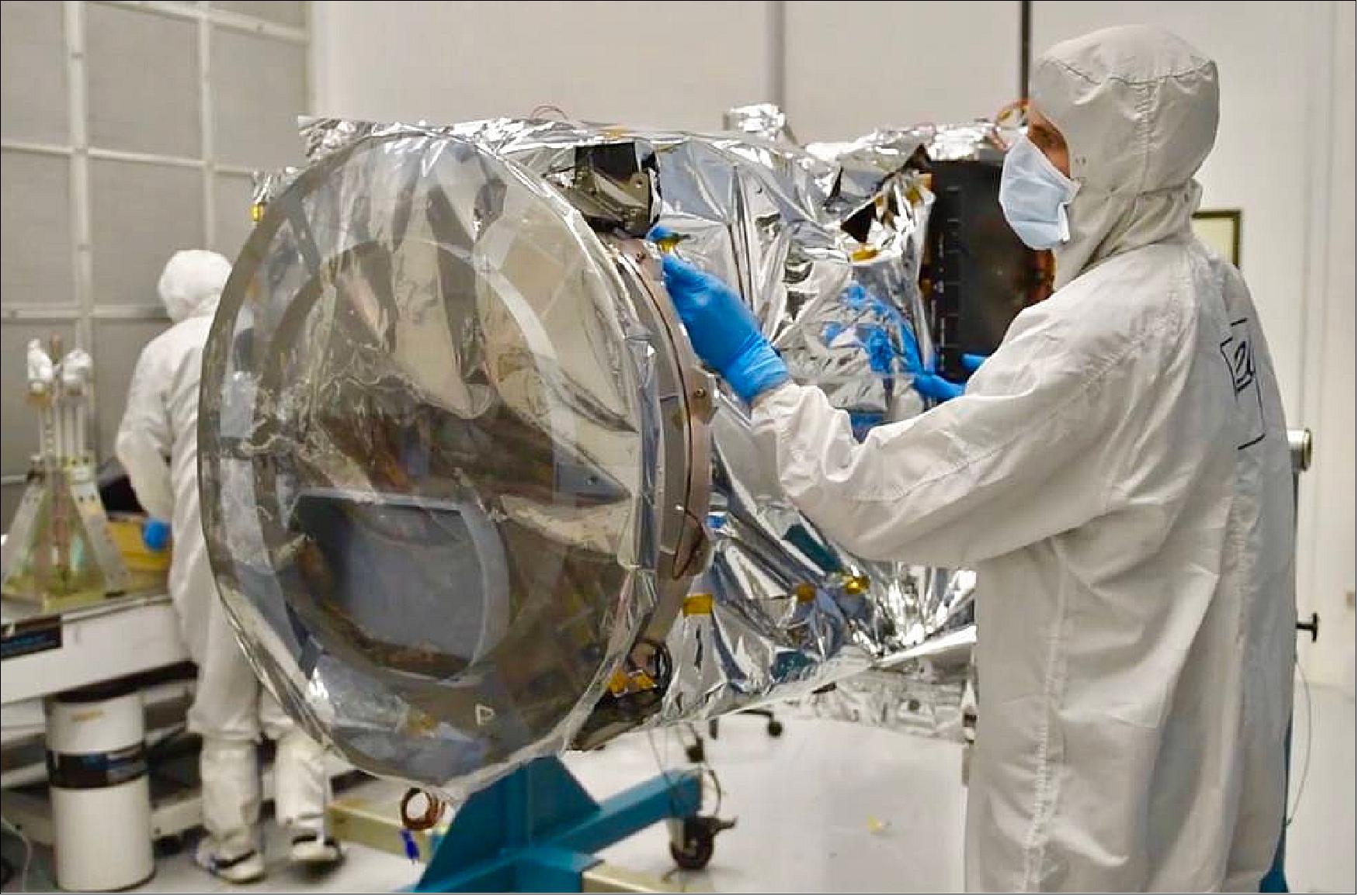
- “With the TEMPO instrument fully spaceflight qualified and safely delivered, we are excited about this important step and look forward to working closely with Maxar for the successful deployment of TEMPO,” said Stephen Hall, TEMPO project manager at NASA's Langley Research Center in Hampton, Virginia.
- TEMPO will contribute to a global air-quality monitoring constellation that will include similar satellites: the European Space Agency’s Sentinel-4, currently in development, and South Korea’s GEMS (Geostationary Environment Monitoring Spectrometer) on Geo-KOMPSAT-2, scheduled to launch in early 2020.
- The instrument’s international science team includes partners in North America, Asia and Europe, and is led by Chance and Deputy Principal Investigator Xiong Liu, also from SAO. Scientists with the Environmental Protection Agency and the National Oceanic and Atmospheric Administration play key roles in the TEMPO science team.
• December 8, 2018: Ball Aerospace has delivered the TEMPO spectrometer to NASA after a successful final acceptance review. Once launched, TEMPO will be a spaceborne ultraviolet/visible light air quality spectrometer in geostationary orbit over greater North America. 20)
- The TEMPO instrument will provide hourly daylight measurements of ozone, nitrogen dioxide and other key elements of air pollution across North America, from Mexico City to Canada and from coast-to-coast. TEMPO's high resolution will allow pollution tracking at micro urban scales every hour and is expected to improve air quality prediction accuracy by 50 percent.
- Ball is a part of a team that has extensive experience in measuring the components of air quality. Ball built the TEMPO instrument at the company's Boulder, Colorado, facility in tandem with GEMS (Geostationary Environmental Monitoring Spectrometer) in order to capture design efficiencies between the two instruments, which share the same technology. GEMS is a joint development effort by Ball and KARI (Korea Aerospace Research Institute), and is part of a global air quality monitoring constellation that includes TEMPO. The TEMPO team includes the Smithsonian Astrophysical Observatory; NASA's Langley Research Center; NASA's Goddard Space Flight Center; the U.S. Environmental Protection Agency; and several U.S. universities and research organizations.
- NASA and Principal Investigator Kelly Chance from the Smithsonian Astrophysical Observatory (SAO) in Cambridge, Massachusetts, partnered with Ball to design, manufacture and test this Earth science instrument. The rigorous environmental test campaign conducted by Ball verifies the Tropospheric Emissions: Monitoring of Pollution, or TEMPO, instrument will survive all of the challenges related to launch, as well as sustained operations in geostationary orbit. 21)
- “TEMPO exploits 30 years of our development of ultraviolet and visible atmospheric spectroscopy to make air quality measurements at revolutionary spectral and spatial scales,” said Chance.
- “With completion of the instrument and full spaceflight qualification by Ball, we are extremely excited about the acceptance of TEMPO, which will lay the framework for NASA and SAO’s critical air quality measurements,” said TEMPO Project Manager Stephen Hall at NASA's Langley Research Center in Hampton, Virginia.
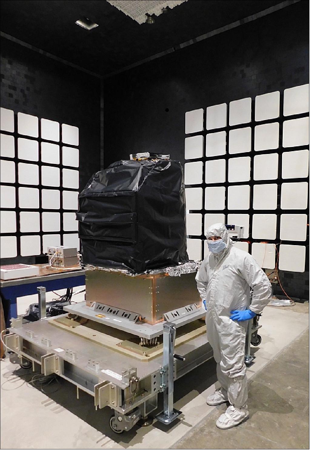
- While NASA has taken ownership of the TEMPO flight hardware, the instrument will remain in storage at Ball until a host spacecraft is selected. NASA will partner with the U.S. Air Force's Space and Missile Systems Center in El Segundo, California, to employ their Hosted Payload Solutions (HoPS) contract to issue a request for proposals from commercial companies to provide satellite integration, launch services and ground operations for TEMPO. Flying on this commercial spacecraft, TEMPO will make observations from a geostationary vantage point, about 22,000 miles above Earth’s equator.
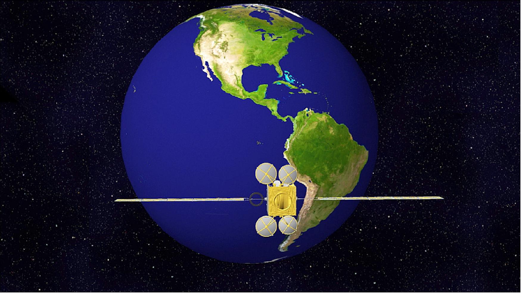
• September 21, 2017: The TEMPO instrument, designed and built by Ball Aerospace for NASA, has completed spectrometer testing and verification. "The completion of characterization and calibration of the TEMPO spectrometer is a critical milestone in the development of our fundamental atmospheric pollution mission, which is a result of collaboration among Ball Aerospace, NASA's Langley Research Center, and the Smithsonian Astrophysical Observatory" said Kelly Chance, TEMPO Principal Investigator, Smithsonian Astrophysical Observatory. "Together, we are all looking forward to the next steps on the way to providing hourly atmospheric pollution measurements for greater North America." 22)
- TEMPO will leverage the Air Force's HoPS (Hosted Payloads Solutions) contract, a service the Air Force uses to match payloads with commercial hosts, such as communications satellites that will fly in geostationary orbits. NASA Langley, located in Hampton, Virginia, manages the TEMPO Mission and will procure the spacecraft host. The launch date is yet to be determined.
• May 4, 2016: TEMPO has now passed the CDRs (Critical Design Reviews) for the instrument (June 24-25 at Ball Aerospace & Technologies Corp. in Boulder, CO) and the Ground System (May 3-4 at SAO in Cambridge, MA). The instrument is well on the way to being fabricated and characterized by Ball, with an expected completion and delivery date in mid calendar year 2017. The Ground System, consisting of the Instrument Operations Center and the Science Data Processing Center, located at SAO, will be completed and fully operational in time for the earliest possible launch date, November 2018. 23)
• Dec. 2015: Subsystems are completing integration and test in preparation for delivery to the TEMPO AI&T (Assembly, Integration and Test) Team. Flight software was completed in October 2015 and flight electronics are in final production. Telescope and spectrometer characterization is planned for mid-2016. Final assembly and environmental testing is planned for late 2016 with delivery to NASA/LaRC in May 2017 (Ref. 14).
• The CDR of TEMPO was successfully completed in late June 2015. 24)
• June 10, 2015: The TEMPO instrument, developed by BATC (Ball Aerospace & Technologies Corp.), is headed toward its CDR (Critical Design Review) this month following an earlier milestone that included PDR (Preliminary Design Review). Ball is now well into the fabrication of the instrument following the successful PDR and a confirmation review. 25)
• On April 10, 2015, TEMPO was confirmed by NASA’s Science Mission Directorate to continue into the development phase of the project. 26) 27)
• TEMPO project passed the SRR (System Requirements Review) and Mission Definition Review in November 2013.
Launch
TEMPO was launched on April 7 2023 into geostationary orbit at 12:30 a.m. EDT, as a secondary payload on the Intelsat 40e communication satellite. 28)
Maxar Technologies and Intelsat recently agreed to partner to host NASA’s TEMPO (Tropospheric Emissions: Monitoring of Pollution) instrument onboard the Intelsat 40e mission. In 2019, NASA selected Maxar to host the TEMPO instrument utilizing the U.S. Air Force Hosted Payload Solutions (HoPS) contract vehicle. Intelsat 40e is based on Maxar's 1300-class satellite platform and will provide commercial satellite communications for Intelsat customers in North and Central America.
TEMPO will make hourly measurements of atmospheric gases — including ozone, nitrogen dioxide and formaldehyde as well as aerosols — across North America and provide air quality products that will be made publicly available and help improve air quality forecasting.
“We are excited about this important step required to lay the operational framework for TEMPO’s critical air quality measurements. We look forward to working closely with both Maxar and Intelsat for the successful integration, launch and deployment of TEMPO,” said Stephen Hall, TEMPO project manager at NASA's Langley Research Center in Hampton, Virginia.
The TEMPO instrument project is led by Principal Investigator Kelly Chance from the Smithsonian Astrophysical Observatory (SAO) in Cambridge, Massachusetts. The instrument was developed by Ball Aerospace in Boulder, Colorado, and is in storage awaiting shipment to Maxar’s satellite manufacturing facility in Palo Alto, California.
TEMPO will be part of a constellation of instruments measuring air quality over the Northern Hemisphere that will also include the European Space Agency's Sentinel-4, currently in development, and South Korea's Geostationary Environment Monitoring Spectrometer, scheduled to launch later this month.
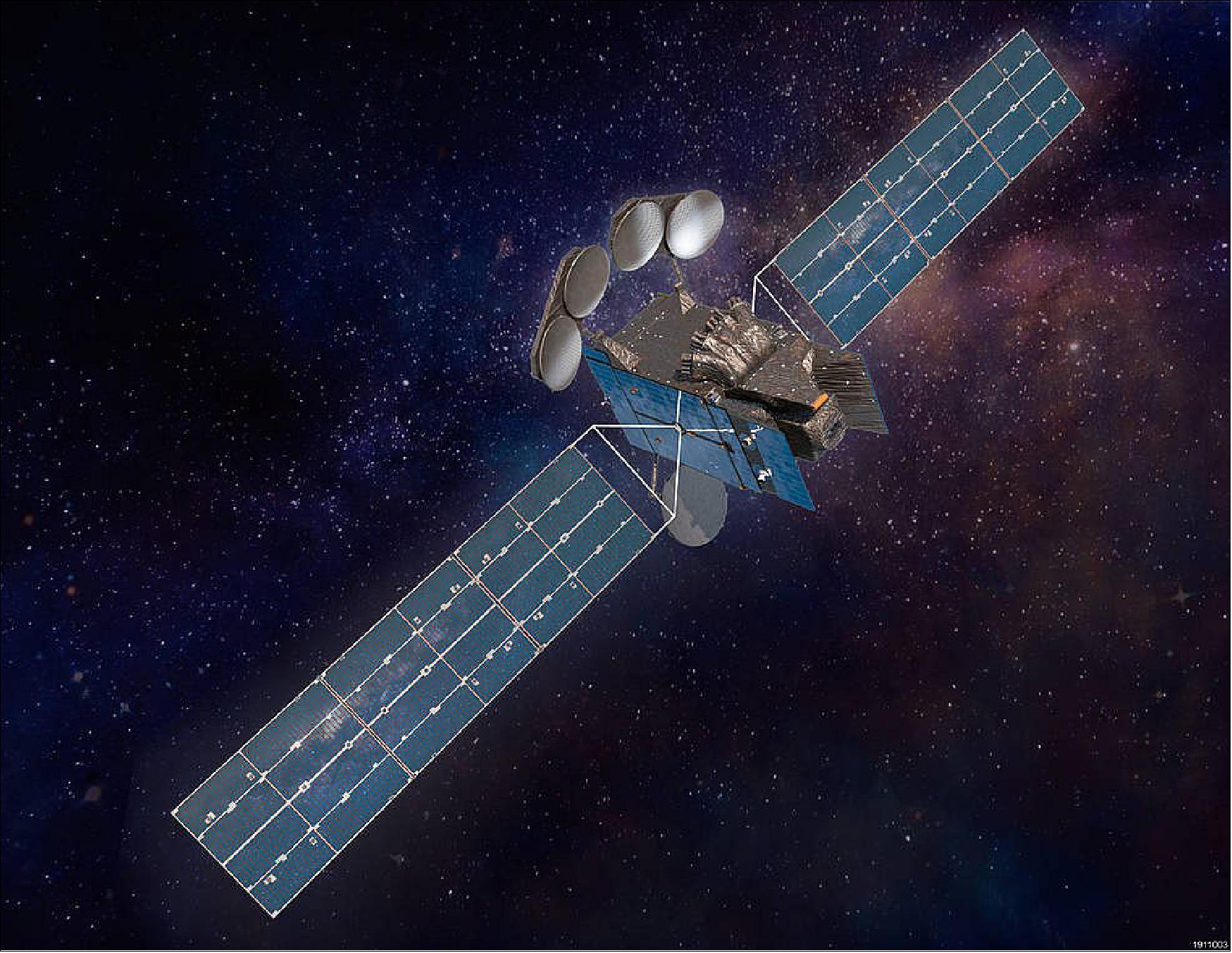
• March 18, 2020: Intelsat announced the selection of the launch provider this week. The mission will launch aboard a SpaceX Falcon-9 launch vehicle. 29)
Orbit: Geostationary orbit, altitude of 35,786 km, an equatorial spacecraft location of 90-110º W is preferred, 80-120º W acceptable.
Sensor Complement
Instrument Concept and Mission Capabilities
The TEMPO instrument is an imaging Offner grating spectrometer measuring solar backscattered Earth radiance. The design will incorporate many of the features and lessons learned from heritage spectrometers flown by Europe and the U.S. The key instrument characteristics and capabilities are: 30) 31)
• Spectral range: 290–740 nm (UV, VIS); spectral sampling: 0.2 nm; spectral resolution: 0.6 nm. A 2D detector (2 k x 2 k pixels) images the full spectral range for each geospatial scene.
• Spatial resolution: 2.1 km/pixel in the north-south direction, 4.7 km /pixel in the east-west direction at the center of the FOR (Field of Regard) — 36.5° N, 100° W. Co-add/cloud clear as needed for specific data products.
• Hourly measurements stepping east to west of the entire FOR (2.5 x 10⁶ spectra/hour).
• Standard data products and sampling rates:
- NO2, O3, aerosol, and cloud products sampled hourly, including eXceL O3 for selected target areas
- H2CO, C2H2O2, SO2 sampled 3 times/day (hourly samples averaged to get S/N)
- Product spatial resolution ≤ 8 km N/S x 4.5 km E/W at center of domain
- Signal/noise requirements met at SZA (Solar Zenith Angles) less than 50° for all products—and at angles up to 70° for NO2, clouds, and aerosols.
- Ozone profile products include 0–2 km O3, free tropospheric O3, and the stratospheric O3 column.
TEMPO measurements will capture the high variability in the diurnal cycle of emissions and their evolving chemistry, which occurs mostly during the day. TEMPO’s footprint — smaller than for previous missions measuring air quality — will resolve pollution sources at suburban scales. With both high temporal and spatial resolution, TEMPO data will improve emission inventories, monitor population exposure to pollution, and make possible effective emission control strategies by regulatory agencies.
The TEMPO instrument is a grating spectrometer, sensitive to visible and ultraviolet wavelengths of light, which will be attached to the Earth-facing side of a commercial telecommunications satellite (to be selected) in geostationary orbit. This allows TEMPO to maintain a constant view of North America so that the instrument's light-collecting mirror can make a complete East to West scan of the FOR (Field of Regard) each and every hour of the day. By measuring sunlight reflected and scattered from the Earth's surface and atmosphere back to the instrument's detectors, TEMPO's ultraviolet and visible light sensors will provide spectra of ozone, nitrogen dioxide, and other elements of daily atmospheric chemistry cycles. 32)
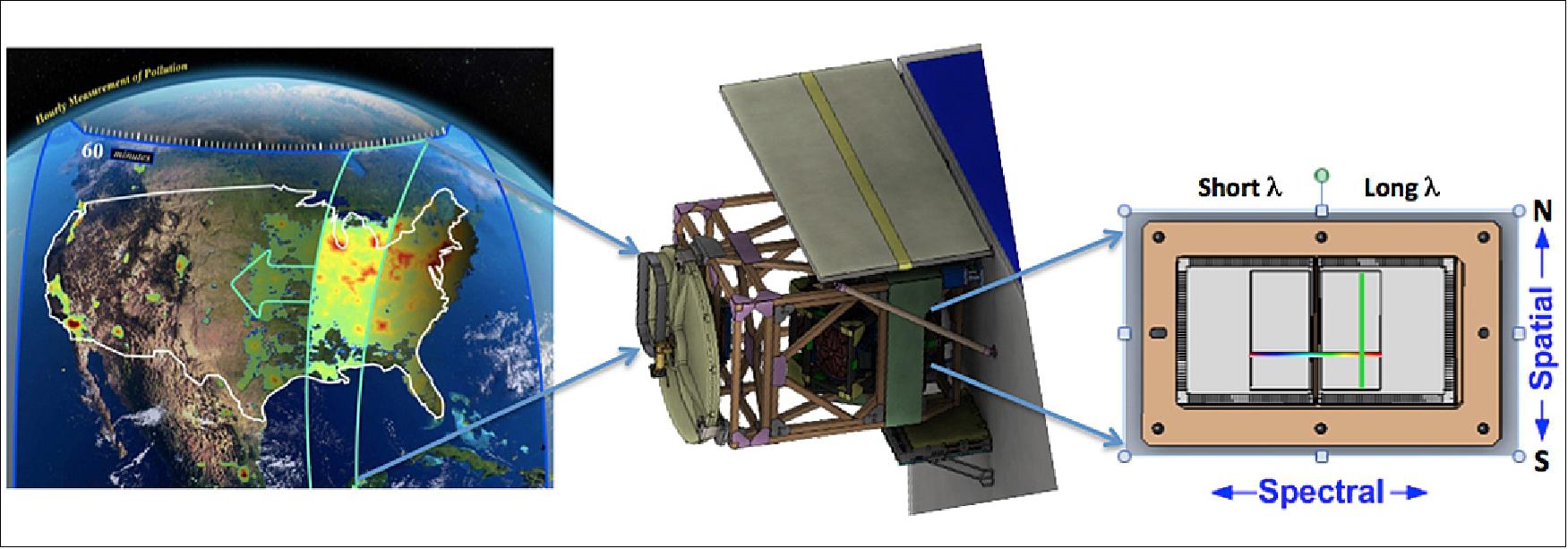
Legend to Figure 11: The scan mirror projects the slit field of view onto GNA (Greater North America). Multiple images are taken at each scan mirror position. Mirror scans from East to West, imaging GNA on a hourly basis.
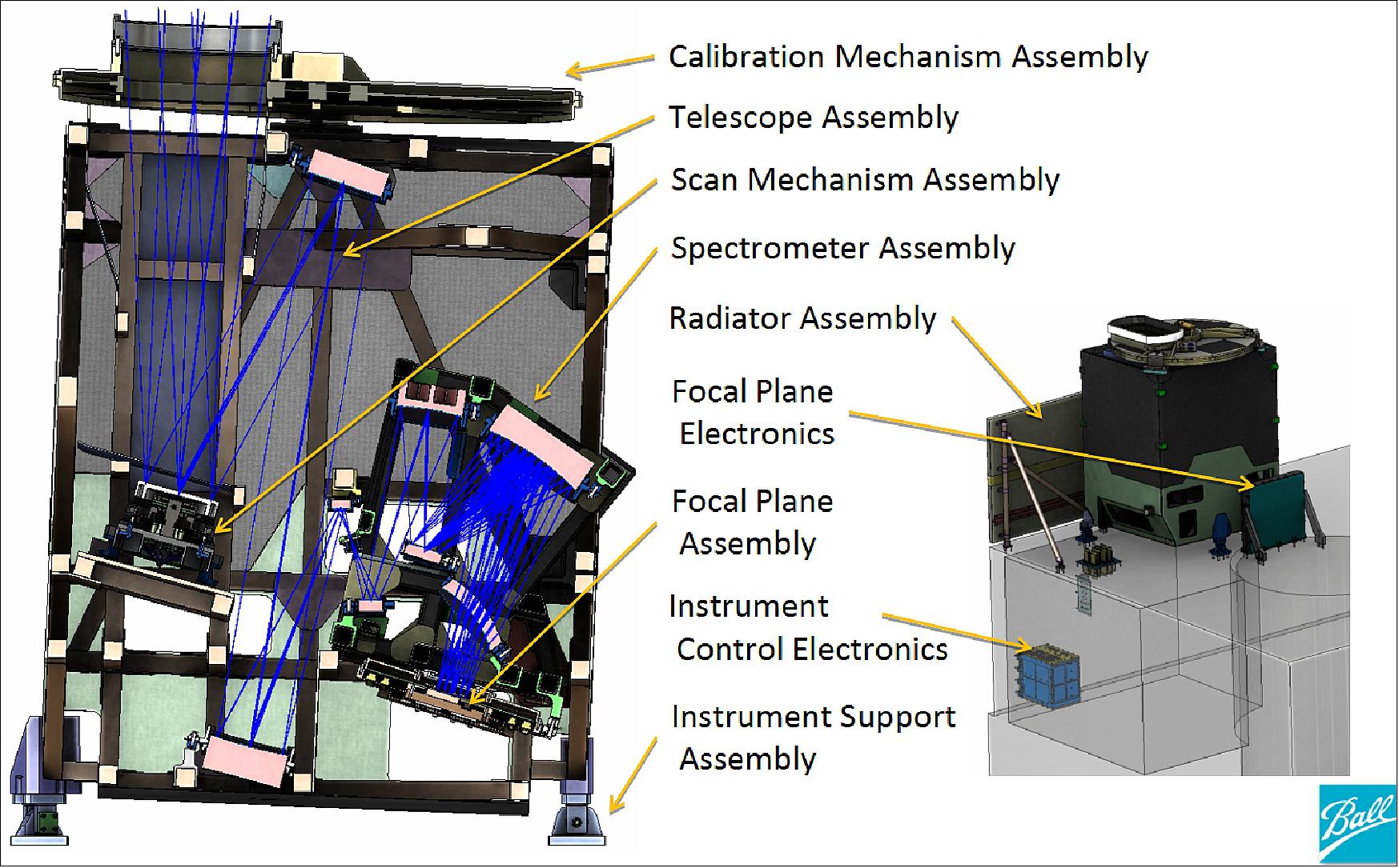
TEMPO will be integrated to the host spacecraft with the nominal optical axis pointed at 36.5°N, 100°W (~5.8° from spacecraft nadir).Its field of regard is designed to cover greater North America as seen from any GEO orbit longitude within 80°W to 115°W. The TEMPO instrument consists of a number of subsystems as indicated in the block diagram shown in Figure 12. The yellow arrows indicate the path of light from the aperture through the optical assembly to the focal plane subsystem (Ref. 10).
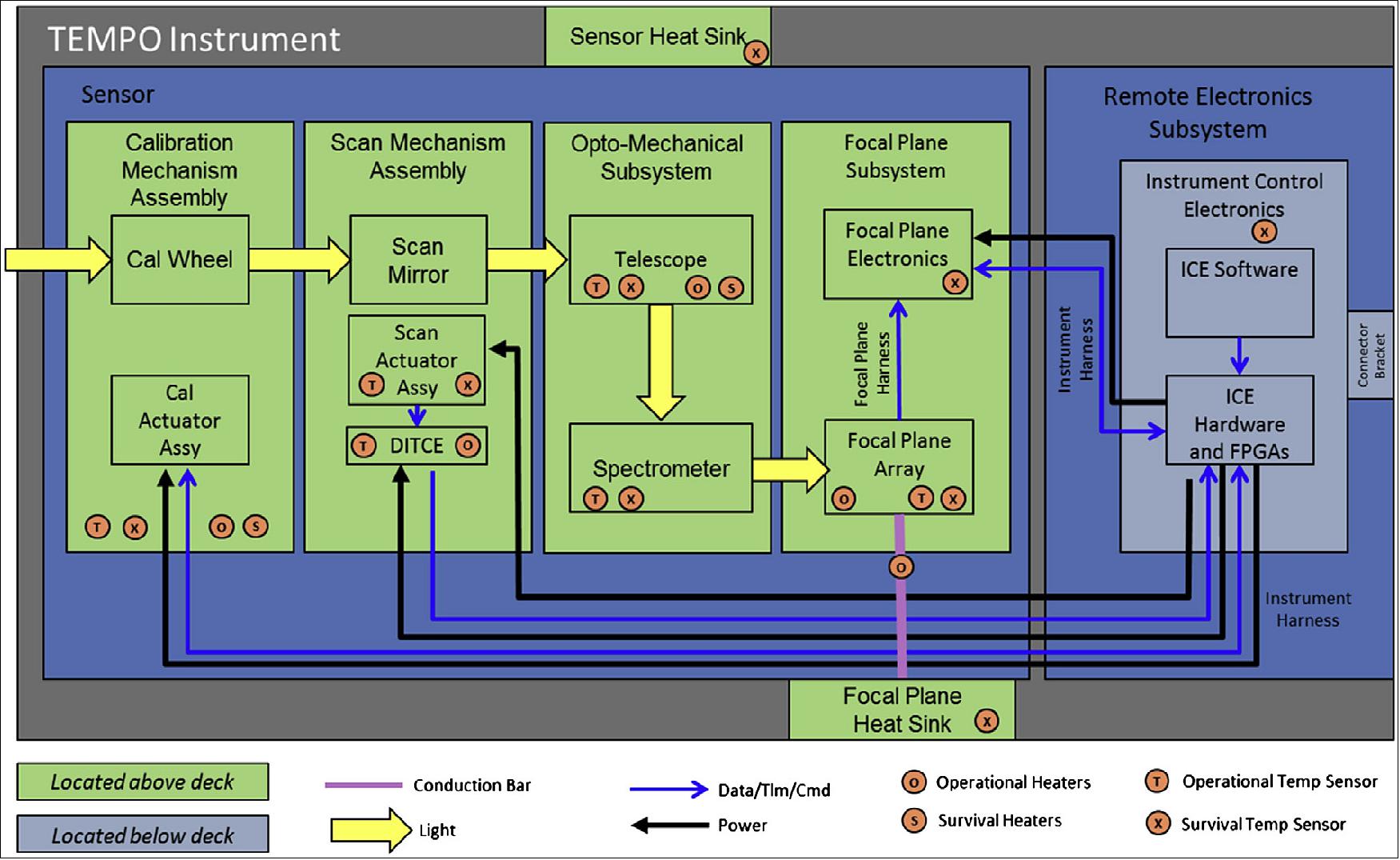
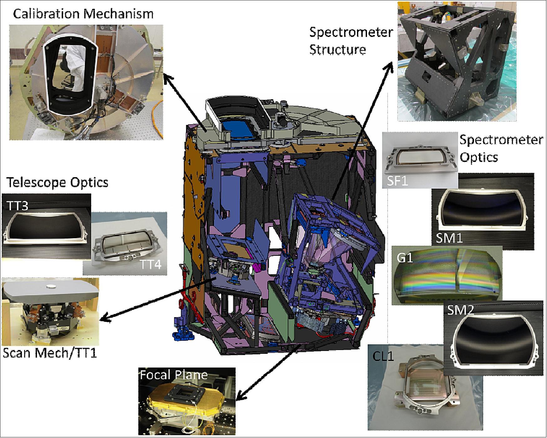
Legend to Figure 12: The TEMPO instrument consists of an off-axis reflective Schmidt telescope and an Offner spectrometer. The yellow arrows through the block diagram represent the optical path through the instrument. DITCE (Differential Impedance Transducer Conditioning Electronics). A graphic of the instrument cross section is shown along with images of actual flight hardware produced to date (Figure 14).
Parameter | Value | Comment |
Instrument mass | 148 kg | Mature mass = CBE + 15% |
Instrument volume | 1.4 x 1.1 x 1.2 m (x, y, z) |
|
Average operational power | 134 W | Mature power = CBE + 10% |
FOR (Field of Regard) | 4.76º N/S x 8.95º E/W | Coverage of GNA (Greater North America) |
GSD (Ground Sample Distance) | 2.21 x 4.97 km (vertical x horizontal) | At Geodetic 36.5º N, 100º W |
Spectral range | 290 – 490 nm, 540-740 nm (UV, VIS) |
|
Spectral resolution, and sampling | 0.57 nm, 0.2 nm |
|
Maximum SNR | 2700 @ 330-340 nm, EOL |
|
Spatial resolution | 2.1 km x 4.5 km @ 36.5 N, 100 W | IFOV: N/S x E/W |
Spectra per hour | 2000 N/S x 1250 E/W |
|
Revisit time | 1 hour |
|
Geolocation uncertainty | 2.8 km |
|
Albedo calibration uncertainty | 2.0% λ-independent, 0.8% λ-dependent |
|
The CMA (Calibration Mechanism Assembly) controls the instrument aperture. It consists of a wheel containing four selectable positions: Closed, open, working diffuser and reference diffuser. The ground fused silica diffusers allow recording of the top-of-atmosphere solar irradiance. Earth-view radiance measurements are made in the open position. The working diffuser is used on a daily basis and the reference diffuser is used to trend any degradation of the working diffuser from radiation exposure and contamination. Dark scene data are collected with the wheel in the closed position (Ref. 10).
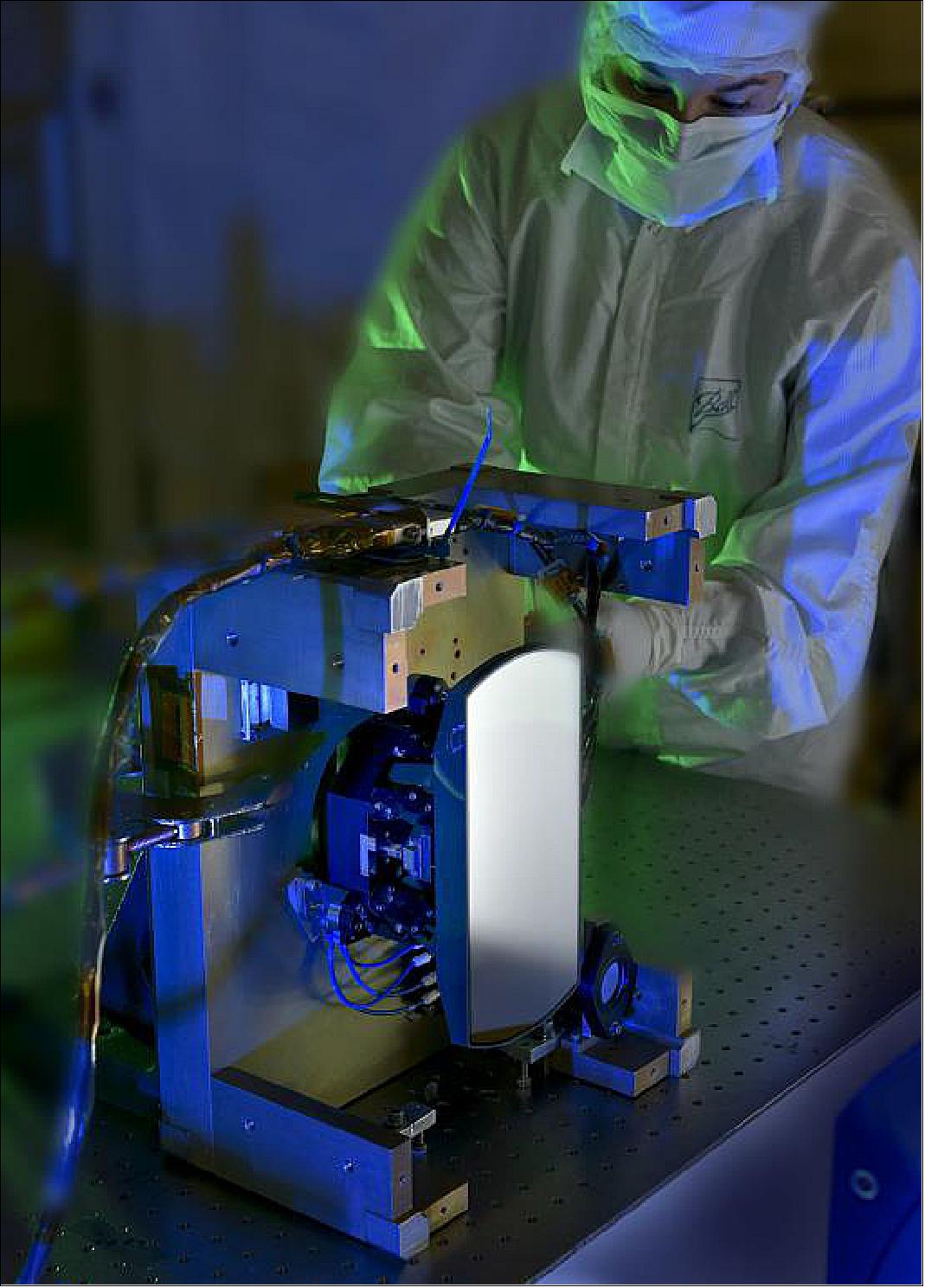
The SMA (Scan Mechanism Assembly) steps the projected TEMPO instrument slit image,or FOV (Field of View), aligned in the North-South direction) across the TEMPO field of regard and compensates for unwanted spacecraft motion. When the instrument is collecting image data, the FOV is held stable at a given ground location while individual images are recorded before stepping to the next location. The SMA is housed as the first optic within the telescope optical assembly. The SMA consists of a silicon carbide mirror gimballed to a two-axis mechanism involving two flex pivots per axis. The mechanism is actuated inductively using a network of voice coils and magnets. The mirror position is measured using DITs (Differential Impedance Transducers). The SMA is close-loop controlled using realtime attitude data supplied by the host spacecraft.
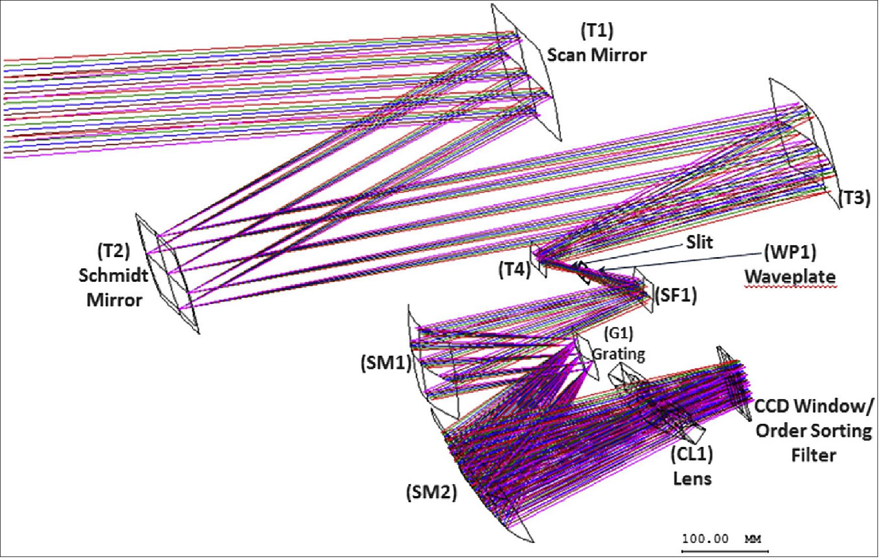
The optomechanical subsystems consist of a telescope and a spectrometer assembly. Primarily, the optical design employs reflective optics with simple geometries(Figure 13). The f/3 Schmidt-form telescope consists of the T1 Scan mirror, the T2 Schmidt mirror and a T3 and T4 with final projection onto the slit of the spectrometer assembly. The telescope mirrors are coated with UV-enhanced aluminum, with the exception of the T2 optic, which has a band-blocking coating to minimize straylight biases within the spectrometer.
The Offner-type spectrometer was chosen due to its compact design and superior re-imaging performance and is similar to the OMPS (Ozone Mapping Profiler Suite) nadir spectrometer. The spectrometer consists of a slit, a quartz wave plate (for polarization mitigation), a diffraction grating, a corrector lens and a CCD window/order sorting filter. The mechanically ruled grating (500 lines/mm) is a convex paneled (3 partite) optic with a blaze angle of 5º at 325 nm. The optical benches are a truss-type design constructed of composite tubes with titanium fittings. The optomechanical system is athermal and actively temperature-controlled for superior spectral stability over changing diurnal and seasonal thermal environments.
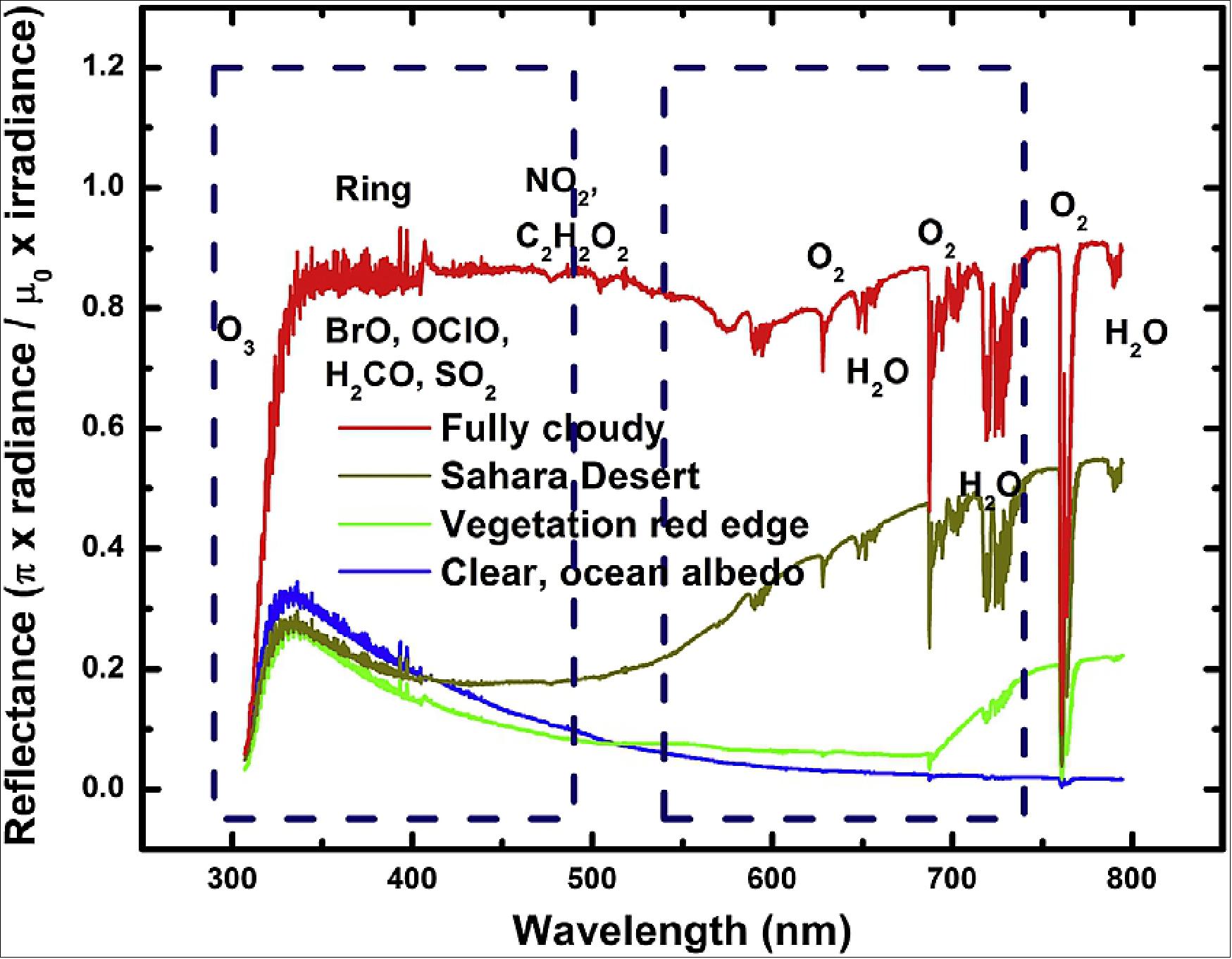
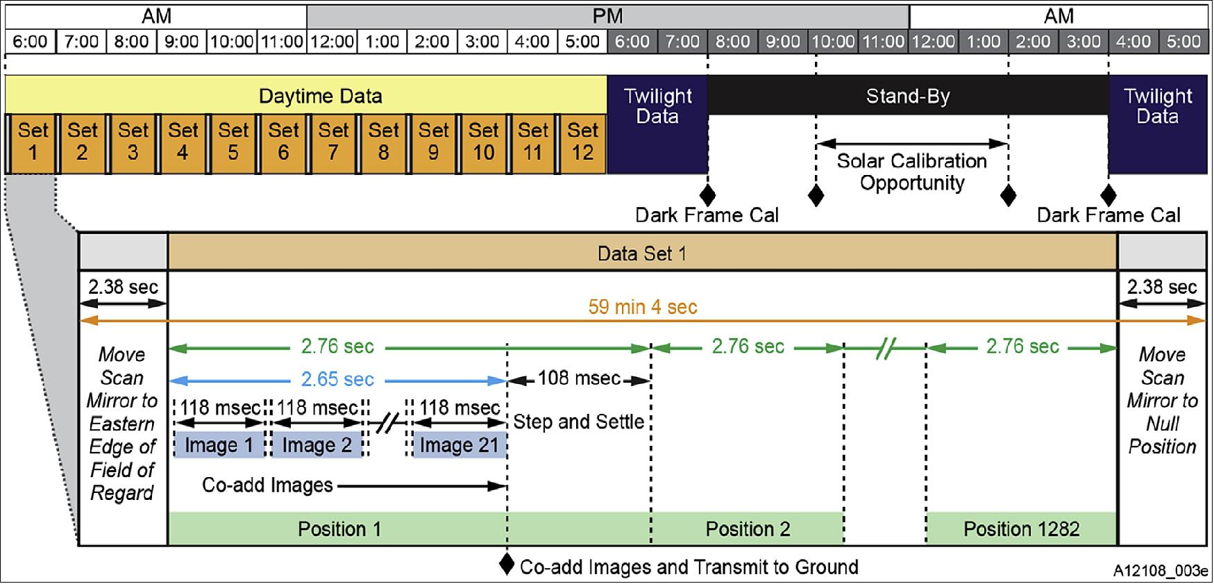
The FPA (Focal Plane Array)and FPE (Focal Plane Electronics) comprise the focal plane subsystem. The FPA contains two separate, but identically designed, 1k x 2k pixels, full-frame transfer, CCD (Charge Coupled Device) detectors. There are 2k pixels each in the spatial direction (along the slit) and 1k pixels each in the spectral direction. 290 nm to 490 nm is measured by the UV CCD and 540 nm to 740 nm by the VIS CCD. The CCDs are back-thinned and have an anti-reflection coating for enhanced operation in the UV. The CCDs are read-out and digitized simultaneously to create spectra with the same period of integration (~118 ms in duration). Multiple integrations (~21) are added together on-board, for a single scan mirror position, before transferring to the host spacecraft for downlink. The CCDs are passively cooled with a dedicated thermal connection to a cold biased spacecraft thermal interface and stabilized with a heater on the thermal connection. The spectral regions to be measured by TEMPO are illustrated in Figure 16 by reflectances for various scenes measured by the ESA (EuropeanSpaceAgency) GOME-1 instrument.
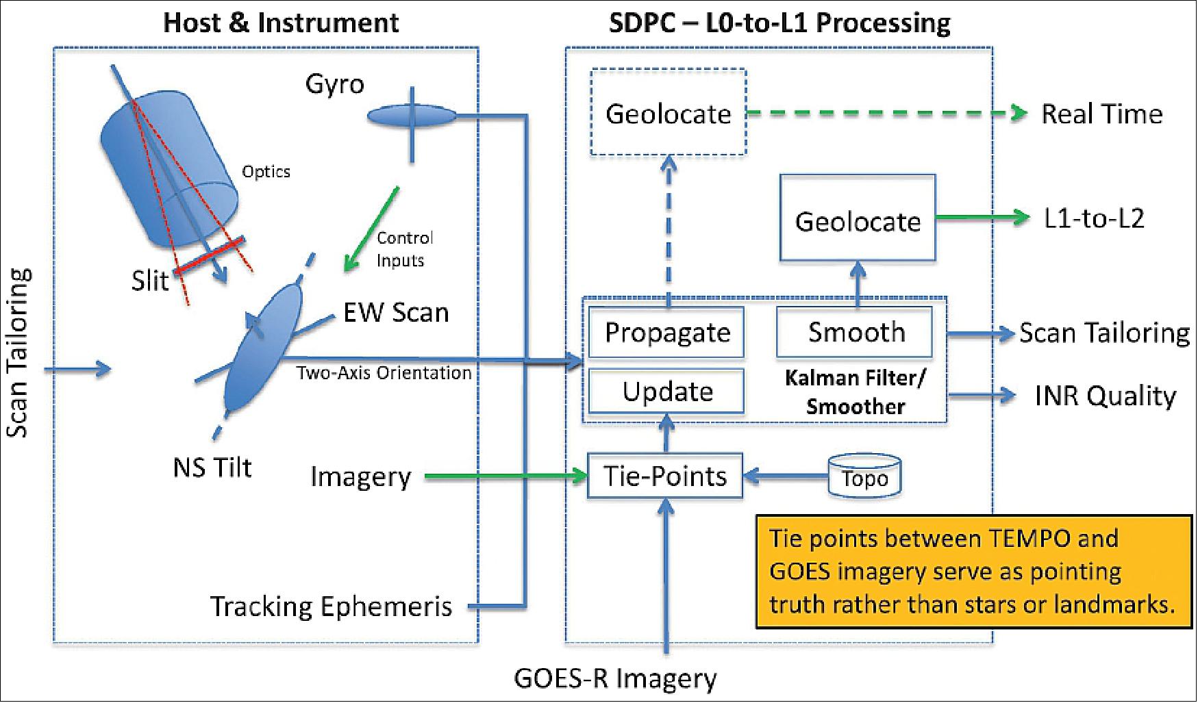
The TEMPO INR solution uses a combination of flight hardware and ground software, as shown in Figure 19, to accurately assign geographic locations to pixels and assure uniform, gapless, and efficient coverage of greater North America. TEMPO INR relies on GOES weather satellite imagery for pointing truth. This is available with ≤ 5 min latency with respect to realtime and is more accurately registered to the Earth than that required by TEMPO. First, a GOES-like image is constructed by weighting the TEMPO spectral planes in accordance with the GOES relative spectral response function. Next, templates are extracted from the GOES-like image and matched against GOES imagery, creating a set of tie-point measurements in progression as TEMPO scans across the domain.
A Kalman filter with a high-fidelity model of the TEMPO system embedded within it is at the heart of the TEMPO INR system. Its state vector is updated with each tie-point measurement and propagated in between measurements using modeled dynamics and spacecraft attitude telemetry from onboard gyroscopes. A tracking ephemeris provided by the host spacecraft operator is also input in to the Kalman Filter. The state vector estimates for each TEMPO dwell time can be used to determine the Earth locations of each of its pixels in realtime. Using attitude data to stabilize the TEMPO line-of-sight pointing by providing control inputs into the SMA as described above enables uniform and gapless coverage of the domain. Other than providing ephemeris and gyroscopes, the host spacecraft is only required to orient TEMPO towards the Earth with an accuracy of 1100 µrad (3σ), a capability well within that of a modern commercial communications satellite. Scan tailoring parameters are routinely generated by the INR processing to predict offsets in pointing to keep the TEMPO field of regard centered over a target Earth location. They are applied to the scan starting coordinates in the scan tables defining the data acquisition schedule, which is updated weekly via command uploads. The tailored scan coordinates reduce the need to overcover the domain, making science data collection more efficient.
The tie-point paradigm is that TEMPO and GOES are looking at the same thing, at the same time, and in the same spectral band;therefore, knowledge of the geographic coordinates of unknown features, even clouds, seen by GOES can be transferred to TEMPO. However, it is important to manage the parallax that may arise because TEMPO is not necessarily stationed at a longitude nearby a GOES spacecraft. We do that by either using a priori knowledge of object height (cloud top height assignment or topographic height for clear skies) to correct the measured displacement or by binocularly solving for the height of the unknown object by matching it with imagery from two different GOES satellites. The Level 2 requirement is that the angular uncertainty of a fixed point be less than 82 µrad (3σ), 4 km in position on the ground at the center of the field of regard. INR performance for TEMPO is figured to be generally better than 56 µrad (3σ), 2.8 km at the center of the field of regard.
A typical day of operations for TEMPO is shown in Figure 17. Earth scans are collected with one-hour revisit time during daylight and twilight (two hours before and after full sunlight). The actual daily timeline will vary seasonally, accounting for temperature and straylight. Solar calibrations may be made when the sun is unobscured at angles ±30° to the instrument boresight. Dark frame calibrations are required to support radiometric accuracy. The nominal scan pattern consists of a series of East-West (E-W) scan mirror steps(~1282) across the field of regard, with the image of the spectrometer slit on the ground defining the North–South extent of the FOV. A continuous subsection of the field of regard may be scanned at shorter revisit time (5–10 min) for episodic pollution events or focused studies.
Science data collection may be optimized in the early morning and late afternoon when significant portions of the field of regard have SZAs (Solar Zenith Angles) >80º. Data with SZA >80° are unsuitable for most of the planned atmospheric chemistry measurements, but can constitute 20% of the data collected with the nominal coast-to-coast hourly scanning. The morning optimized data collection will terminate the nominal E-W scan pattern when the SZA >80° throughout the FOV (governed mainly by the SZA at the southern extent of the FOV), and proceed back to the East-most portion of the field of regard to commence a new E-W scan. Since the entire field of regard is not scanned, the revisit time is less than the nominal 1-h (as small as5 min) as the scan termination point follows the terminator (SZA>80°) across greater North America. In the afternoon, as the evening terminator progresses westward across the field of regard, data collection will use multiple scan tables to essentially move the initial point of the scan, skipping FOVs with SZA >80º.
Challenges of Being a Hosted Payload (Ref. 30):
TEMPO is the first NASA EVI (Earth Venture Instrument) and the first to go through the process of finding a host spacecraft. The primary challenge for a hosted payload developer is the lack of a host with whom to discuss and negotiate interface requirements. To assist payload developers with this challenge, NASA has developed a set of CII (Common Instrument Interfaces) guidelines. The CII guidelines were developed by using a compilation of interface and environmental requirements. The guidelines are helpful in that they inform payload suppliers with the wide range of potential requirements. For instance, the launch loads contained in the CII envelope many potential spacecraft buses and launch vehicles. Using the loads indicated in the CII would cause a payload developer to over-specify and over-design a payload from a structural point of view. This potential issue can be mitigated with an early selection of a host spacecraft provider. In the absence of an early selection, it is recommended that the CII guidelines be tailored based on the probability of each spacecraft and launch vehicle combination. This approach helps to identify low-probability combinations of spacecraft and launch vehicle that may be driving requirements (and cost) of the hosted payload. The TEMPO mission team at NASA/LaRC in charge of the selection of the TEMPO host has been working closely with the TEMPO instrument team to help minimize any risks of over-design and over-test.
The TEMPO mission requires precise pointing and stability for imaging. Undesirable jitter and drift can cause degradation of the TEMPO data. In a dedicated Earth remote sensing mission, the spacecraft and instrument would be designed such that the system would meet these pointing stability requirements. Commercial communication satellites have stability requirements to carry out radio frequency (RF) communications missions. While RF communication missions require good pointing, they can accommodate some level of drift. These levels of drift would significantly impact an optical remote sensing mission such as TEMPO. To mitigate this issue, the TEMPO instrument includes a high precision scan mirror. The scan mirror uses position feedback from an inertial sensor (3-axis gyroscope). The scan mirror controller uses closed-loop control to take out spacecraft jitter and drift, while scanning the instrument’s narrow East-West FOV, over the wide-area field of regard. The TEMPO scan mechanism assembly could provide this capability to other hosted payloads that require similar high-precision pointing (Figure 18).
Ground Segment
The TEMPO space segment consists of the TEMPO instrument and the host spacecraft. The host spacecraft vendor is responsible for the integration of the TEMPO instrument to the host spacecraft.
The ground segment consists of the IOC (Instrument Operations Center)and the interface to the host SOC (Spacecraft Operations Center). The science segment includes the SDPC (Science Data Processing Center). SAO developed the IOC and the SDPC. The ground segment commands the instrument, monitors instrument health and status telemetry, and to receive and transfer science data from the instrument to the IOC and SDPC. The SDPC receives science and telemetry data from the IOC, performs all data processing needed to generate science products, and distributes data products including transmitting all data and products for archival (Ref. 10).
TEMPO Operations
The TEMPO ground system commands the instrument, monitors instrument health and status, and produces Level-0 science data for delivery to the SDPC. TEMPO instrument telemetry is downlinked to the hosts's SOC (Science Operations Center) and then forwarded to the TEMPO IOC, where the telemetry packets are decommutated and processed to Level 0. The IOC autonomously limit-checks the instrument H&S (Health and Status) data and alerts the operators of any out-of-limit conditions. The H&S data are stored in the IOC (Instrument Operations Center) for the life of the mission to support remote monitoring, trending, and anomaly resolution. The web-based remote monitoring system allows the operators to graphically view the H&S data in realtime and to create plots of the data over arbitrary time intervals. The IOC extracts image data from the telemetry packets to reconstruct CCD image frames.
The reconstructed images are sent to the SDPC for assembly into granules for further processing. The IOC also sends gyroscope and scan mechanism controller data to the SDPC to support image pixel geolocation. The commanding component of the IOC utilizes the Ball Aerospace COSMOS command and telemetry system in conjunction with the instrument simulator for command planning, generation, and validation. TEMPO operates from a 14-day command sequence that controls the day-to-day scanning and calibration activities. New14-day command sequences that incorporate the latest predicted ephemeris and scan tailoring information from INR (Image Navigation and Registration) processing are developed and uplinked on a weekly basis. In the event of a special observation, the currently executing command sequence can be interrupted and replaced.
Data Processing and Availability
The TEMPO instrument operations center at SAO receives telemetry from the host spacecraft operations center. Level 0 science data are passed to the TEMPOS DPC for processing and distribution. In the SDPC, Level 0 data from radiance scans are gathered into granules having sufficient east-west coverage to enable geolocation, typically about 5 min of scan data. Initial radiometric calibration converts the Level 0 digital numbers into physical units, including a stray light correction, and an initial wavelength calibration. When initial radiometric calibration is complete,INR processing derives the latitude-longitude coordinates of the center and corners of each pixel. Knowledge of the scattering geometry facilitates the polarization correction that is applied in producing the final Level 1 radiance spectra.
An irradiance spectrum is acquired each night when the sun is 30º from the boresight, usually about two hours before midnight. Consistent irradiance measurement geometry reduces variability associated with angular dependence of the diffuser bidirectional transmittance distribution function. For each Level 1 radiance granule, the Level 2 cloud product is generated first, then the other Level 2 products are generated using the cloud product as input along with the most recent irradiance measurement. The computational cost of the Level 2 ozone profile product is much greater than that of the other Level 2 data products. For this reason, the Level 2ozone profile product is generated by first coarsely binning each radiance granule, then dividing each granule into many small blocks (e.g. 64 blocks), and processing the small blocks in parallel. Level 3 data products are generated by gridding hourly scans of level 2 data products to standard longitude-latitude grid cells (except the cloud product). All TEMPO data products are stored in net CDF4/HDF-5 format in a data archive at SAO for the life of the mission.
New data products are made available from a website at SAO where data products are organized by date and product type. The website provides access to the most recent 30 days of TEMPO data. Throughout the mission, new data products are regularly (e.g. weekly) transferred to NASA's Atmospheric Science Data Center for public distribution. To facilitate browsing and subsetting, TEMPO data are also made available through EPA's (Environmental Protection Agency) RSIG (Remote Sensing Information Gateway).
Global Constellation and International Partnerships
TEMPO is part of a virtual satellite constellation, fulfilling the vision of the IGOS (Integrated Global Observing System) for a comprehensive measurement strategy for atmospheric composition. TEMPO team members have been key participants in international activities to define this potential under the auspices of CEOS (Committee on Earth Observation Satellites), and as members of Korean and European mission science teams. The constellation will become a reality in the 2020 timeframe, including regional geostationary observations over the Americas (TEMPO), Europe (Sentinel-4), and Asia (GEMS) combined with LEO (Sentinel-5/-5P) observations to provide full global context. Mission team members are now working together on data harmonization activities, featuring common data standards and validation strategies, to provide truly interoperable data products from this satellite constellation.
Europe: S4 (Sentinel-4)
The S4 mission, expected to launch in 2021, together with Sentinel-5 and the Sentinel-5 Precursor missions, is part of the Copernicus Space Component dedicated to atmospheric composition. The objective of the S4 mission is to provide hourly tropospheric composition data mainly on an operational basis in support of the air quality applications of the Copernicus Atmosphere Monitoring Services over Europe.
The S4 instrument is a UV/VIS/NIR spectrometer (S4/UVN) that will fly on the geostationary Meteosat Third Generation-Sounder (MTG-S) platforms in order to measure Earth radiance and solar irradiance. The S4/UVN instrument measures from 305 nm to 500 nm with a spectral resolution of 0.5 nm, and from 750 nm to 775 nm with a spectral resolution of 0.12 nm, in combination with low polarization sensitivity and high radiometric accuracy. The instrument observes Europe with a revisit time of one hour. The spatial sampling distance varies across the geographic coverage area and is 8 km at the reference location at 45°N.
ESA is responsible for the development of the S4/UVN instrument, the Level-1b Prototype Processor (L1bPP), and the Level-2 Operational Processor (L2OP). Instrument and L1bPP are built by a consortium led by Airbus Defence and Space. The L2OP is developed by a consortium led by DLR. It covers key air quality parameters including tropospheric amounts of NO2, O3, SO2, H2CO, and C2H2O2, as well as aerosols, clouds, and surface parameters. Two S4/UVN instruments are expected to be flown in sequence spanning an expected mission lifetime of 15 years. EUMETSAT operates the instrument and processes the mission data up to Level-2.
Korea: GEMS (Geostationary Environment Monitoring Spectrometer)
GEMS is a scanning UV/VIS imaging spectrometer planned for launch into geostationary orbit in 2019 over Asia to measure tropospheric column amounts of O3, NO2, H2CO, SO2 and aerosols at high temporal and spatial resolution. With the recent developments in remote sensing with UV/VIS spectrometers, vertical profiles of O3 (e.g. and centroid height of aerosols(e.g. can be retrieved as well. The required precisions of the products are comparable to those of TEMPO and S4. GEMS is a step-and-stare scanning UV/VIS imaging spectrometer, with a scanning Schmidt telescope and Offner spectrometer,similar but not identical to TEMPO. The spectral coverage of GEMS is from 300 nm to 500 nm, with the resolution of 0.6 nm, sampled at 0.2 nm. A UV-enhanced 2D CCD takes images, with one axis spectral and the other north-south (NS) spatial, scanning from east to west (EW) over time. GEMS covers important regions in Asia including Seoul, Beijing, Shanghai, and Tokyo from 5ºS to 45ºN in latitude, and from 75ºE to 145ºE in longitude, with the spatial resolution of 7 km (NS) x 8 km (EW) at Seoul. The planned minimum mission lifetime is 7 years.
On orbit calibrations are planned, making daily solar measurements and weekly LED light source linearity checks. For the solar calibration, there are two transmissive diffusers, a daily working one and a reference diffuser used twice a year to check the degradation of the working one. Dark current measurements are planned twice a day, before and after the daytime imaging. In order to avoid dark current issues and RTS (Random Telegraph Signal), the CCD is cooled to -20°C. Spectral stability is required to be better than 0.02 nm over daily observation hours, straylight less than 2%, polarization sensitivity less than 2% at the instrument level, and the instrument system level MTF (Modulation Transfer Function) better than 0.3 Nyquist.
Canada
TEMPO provides a unique opportunity to provide consistent and timely air quality information to over 99.5% of the Canadian population. TEMPO data are of particular interest to Canada given the challenges in observing its vast land area from ground-based measurements alone. A primary application of TEMPO data is assimilation into the EC (Environment Canada) air quality forecast system for the purpose of improving air quality forecasts over a domain that largely overlaps with the TEMPO field of regard. Other priority application areas include environmental assessment, epidemiological analyses, health impact studies, and monitoring of natural disasters such as forest fires.
To fully exploit TEMPO, Canada is interested in enhancing TEMPO data quality at higher latitudes where:larger average solar and viewing angles lead to reduced sensitivity of some gases (e.g.,O3 and NO2) to the boundary layer; stratospheric abundances of some absorbers (also O3 and NO2) are larger and display greater variability thereby making them more difficult to remove; TEMPO pixel sizes are larger than at lower latitudes; and where trace gas retrievals in forest fires are complicated by high aerosol loading. Issues in the representation of snow-covered surfaces also lead to larger uncertainties. Canadian academia and government are collaborating to address these by developing direct inversions to improve sensitivity in the boundary layer, developing methods to better constrain stratospheric abundances including assimilation of stratospheric profiles, implementing an improved representation of snow in the inversions, and developing algorithms to explicitly account for th e effects of aerosols on trace gas retrievals. Validation of TEMPO observations over Canada is also a priority with an expansion of the Canadian Pandora network and an aircraft measurement campaign being planned.
Mexico
The TEMPO field of regard will cover at least 78% of the Mexican territory, including the Mexico City Metropolitan Area with its 21 million inhabitants . Mexico City is one of the best-monitored urban areas in the world with an air quality network (GDF-SEDENA) run by the city government that has records beginning in 1986 and is now comprised of over 30 stations. Most of these stations measure air pollutants (e.g., O3, CO, NOx, SO2, PM2.5) continuously and are used to advise the authorities when additional measures need to be taken in case of critical pollution events and research purposes. Other large cities with air quality measurements include Monterrey, Guadalajara, Toluca, Tijuana and Mexicali but most of the country lacks information to assess the impacts of air pollution. Therefore, the national environmental institute INCECC (Instituto Nacional de Ecologíay Cambio Climático) and SAO have signed a memorandum of understanding in order to work towards making the data produced by TEMPO available and useful for the Mexican public.
A strong academic collaboration has been established with UNAM (National Autonomous University of Mexico). Together with other institutions and universities, a nationwide network of atmospheric observatories (RUOA) has been established to continuously measure additional species including black carbon and greenhouse gases. A network of four MAX-DOAS instruments has been installed in Mexico City, producing NO2 and H2CO total vertical columns with high temporal resolution. The data produced in Mexico City and other locations will be part of the validation efforts of TEMPO.
The TEMPO observations over Mexico are of particular interest to better characterize emissions from industrial and urban regions which are poorly studied. Biomass-burning sources particularly during the distinctive dry season and the harmful agricultural practices in many parts of the country are monitored by TEMPO. This will be of great value to alert vulnerable communities and prevent damages as well as to increase the understanding of the variability and dynamics of transported pollution plumes.
TEMPO Science Products
Standard data products: TEMPO will measure as standard data products the quantities listed in Table 3 for greater North America. The O3 products, NO2, and H2CO are required products and meet precision requirements up to 70° SZA (Solar Zenith Angle). The spatial and temporal resolutions and SZA constraints are for meeting the requirements only. Operational retrievals will be done hourly at native spatial resolution (~2.1 x 4.4 km2) during the day-lit period except for ozone profile retrievals at the required spatial resolution of ~8.4 x4.4 km2 (four co-added pixels for increased signal and reduction of computational resources). Precisions are listed for all species for four co-added pixels, as that is the form of the NASA precision requirements for the mission.
Species/Products | Typical valuea | Required precisiona |
O3 Profile, 0-2 km(ppbv), FT (ppbv)b, SOCb | 40, 50, 8 x 10³ | 10, 10, 5% |
Total O3 | 9 x 10³ | 3% |
NO2c | 6 | 1.00 |
H2COc (3 measurements per day) | 10 | 10.0 |
SO2c (3/day) | 10 | N/A |
C2H2O2 (3/day) | 0.2 | N/A |
H2O | 3 x 10⁸ | N/A |
BrO | 5 x 10⁻² | N/A |
AOD (Aerosol Optical Depth) | 0.1-1 | 0.05 |
AAOD | 0-0.05 | 0.03 |
Aerosol Index (AI) | -1 to +5 | 0.2 |
Cloud Fraction | 0-1 | 0.05 |
Cloud Top Pressure (hPa) | 200-900 | 100 |
Legend to Table 3:
Spatial resolution: 8.4 x 4.4 km2 at the center of the field of regard. Time resolution: Hourly unless noted.
Expected precision is viewing condition dependent. Results are for nominal cases.
UV indices, including the erythemally weighted irradiance are derived from O3 and other parameters.
a Units are 1015 molecules cm-2 for gases and unitless for aerosols and clouds unless specified.
b FT = free troposphere, 2 km – tropopause; SOC – stratospheric O3 column.
c Background value. Pollution is higher, and in starred constituents, the precision is applied to polluted cases.
Additional data products:
Volcanic SO2 (column amount and plume altitude) and diurnal out-going shortwave radiation and cloud forcing are potential research products. Additional cloud/aerosol products are possible using the O2-O2 collision complex and/or the O2 B band. Additional aerosol products will combine measurements from TEMPO and GOES-R. Nighttime “city lights” products, which represent anthropogenic activities at the same spatial resolution as air quality products, may be produced twice per day (late evening and early morning) as a research product. Meeting TEMPO measurement requirements for NO2 (visible) implies the sensitivity for city lights products over the CONUS within a 2 h period at 8.4 x 4.4 km2 to 4.25 x 10⁻⁹ W cm-2 sr-1 nm-1.
International Collaboration
A single geostationary satellite views only one sector of the globe, limiting the capability to observe sources of pollution outside the instrument FOR. Fortunately, both Korea with GEMS (Geostationary Environment Monitoring Spectrometer) to be flown on GeoKOMPSAT-2B, and Europe (ESA and EUMETSAT) with the UVNS (UV NIR Spectrometer) on Sentinel-4, plan to develop and launch their own instruments to fly on geostationary satellites to measure air composition and quality in the 2017-2022 timeframe. These missions will have measurement capabilities and science objectives similar to TEMPO. Therefore, it will be possible, with a minimum of three geostationary satellites positioned to view Europe, East Asia, and North America, to collectively provide near-global coverage in the Northern Hemisphere. The synergy of contemporaneous satellite missions having similar observing capabilities and data distribution protocols will provide unique opportunities to advance understanding of the interactions between regional and global atmospheric composition in the troposphere. This would include assessments — not possible before — of emission sources, intercontinental pollution trans-port, and regional interactions between air quality and climate. These activities would address several societal benefit areas of GEOSS (Global Earth Observation System of Systems), (Ref. 8).
In addition to TEMPO, the European Sentinel-4 and the Korean GeoKOMPSAT missions have been approved. By harmonizing these missions it is possible to improve the scientific return and societal benefit of each of the individual missions while beginning a global observing system that will be impossible for any one country to implement alone. Best efforts to cooperate on defining common requirements and data products can enable improved designs for all instruments and allow cost savings by minimizing duplication of effort. While recognizing that unique requirements likely exist for individual missions, this approach defines common objectives that build a foundation for a future integrated observing system for atmospheric composition, as envisioned in 2004 by the IGOS (Integrated Global Observing System).
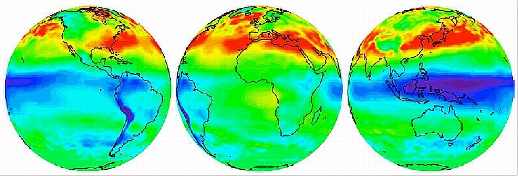
Legend to Figure 20: The 3 images show simulation of average tropospheric ozone — an indicator of poor air quality — using data from Aura’s OMI and MLS (Microwave Limb Sounder) when viewed from three geostationary positions over major continents for May-July 2008. The three geostationary missions (i.e., originated by NASA, ESA, and Korea) however, will focus on the Northern Hemisphere only. Shades of purple and blue correspond to 10-20 DU (Dobson Units), representing low ozone amounts, while lighter shades correspond to 35-50 DU. Green, yellow, and red indicate high-pollution areas.
The simultaneous development of these individual missions to acquire data over Earth’s major industrialized regions presents a real opportunity for international collaboration to improve the preparation for these missions and their combined capabilities within a global system. Best efforts are all ready underway to cooperate on defining common measurement requirements, retrieval algorithms, validation, data quality, and access to achieve the above goals. Consistency of data products will result in better understanding of the science, improved application capabilities, and subsequent use by regulatory agencies.
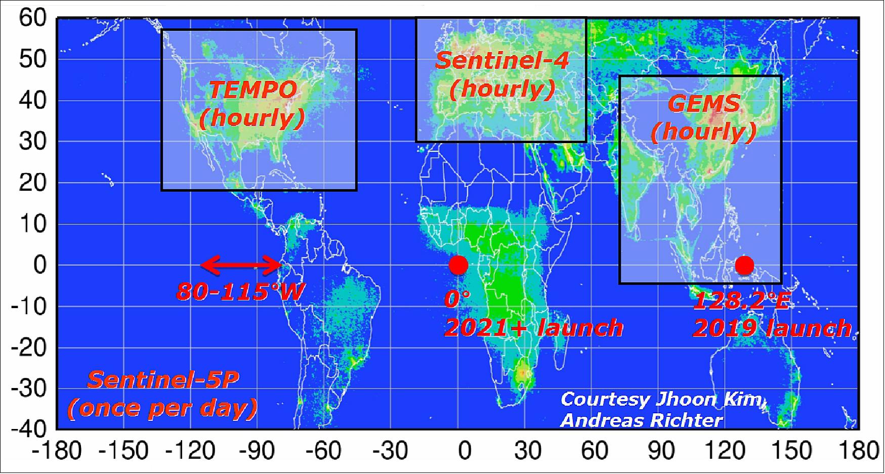
References
1) Steve Cole, “New Space Sensor as a Hosted Payload to Track Air Pollution Across North America,” NASA Release: 12-390, Nov. 08,2012, URL: http://www.nasa.gov/home/hqnews/2012/nov/HQ_12-390_TEMPO_Instrument.html
2) “Langley-Led Project to Build Space-Based Pollution Monitor, NASA/LaRC, Nov. 19, 2012, URL: http://www.nasa.gov/centers/langley/science/TEMPO.html
3) “Ball Aerospace Selected by NASA for TEMPO Air Pollution Mission,” BATC, Nov. 19, 2013, URL: http://www.ballaerospace.com/page.jsp?page=30&id=501
4) Andrea Martin, “TEMPO, the Recently-Selected Earth Venture Instrument for Daytime Pollution Monitoring, Enabled by Key Early Technology Investments,” NASA, Dec. 2012, URL: https://web.archive.org/web/20170513074647/https://esto.nasa.gov/news/news_TEMPO_12_2012.html
5) Kelly Chance, Brad, Pierce, “TEMPO, keeping the beat with Air Quality, Tropospheric Emissions: Monitoring of Pollution,” CIMSS Science Symposium, Madison, Wisconsin, USA, Dec. 12, 2012, URL: http://www.ssec.wisc.edu/news/media/2013/01/pierce.pdf
6) Kelly Chance, Xiong Liu, Raid M. Suleiman, David Flittner, Jay Al-Saadi, Scott Janz, “Tropospheric Emissions: Monitoring of Pollution Overview”, ACC-11 (Atmospheric Composition Constellation), Frascati, Italy, April 29-30, 2015, URL: https://www.cfa.harvard.edu/atmosphere/publications/TEMPO-ACC11-Overview-29apr2015.pptx
7) Kelly Chance, Xiong Liu, Raid M. Suleiman, David E. Flittner, Jassim Al-Saadi, Scott J. Janz, ”Tropospheric emissions: Monitoring of pollution (TEMPO),” Proceedings of SPIE, Vol. 8866, 'Earth Observing Systems XVIII, 88660D (September 23, 2013),' San Diego, CA, USA, Aug. 25, 2013, URL: https://www.cfa.harvard.edu/atmosphere/publications/TEMPO-SPIE-2013-24aug2013.pdf
8) Ernest Hilsenrath, “NASA Ups the TEMPO on Monitoring Air Pollution,” The Earth Observer Newsletter, Harvard-Smithsonian Center for Astrophysics, March-April 2013, Volume 25, Issue 2, URL: http://www.cfa.harvard.edu/atmosphere/publications/TEMPO-EO-2013.pdf
9) Ewan O’Sullivan and the TEMPO team at SAO (Kelly Chance, Xiong Liu, Raid Suleiman, John Houck, John Davis,C. Nowlan, G. Gonzalez-Abad, P. Zoogman, H. Wang, et al. ), ”Tropospheric Emissions: Monitoring of Pollution (TEMPO),” SAO HEAD lunch talk, 17 February 2016, URL: http://www.sr.bham.ac.uk/~ejos/files/EOS_TEMPO_HEADtalk_public.pdf
10) P.Zoogman, X.Liu, R.M.Suleiman, W.F.Pennington, D. E. Flittner, J. A. Al-Saadi, B.B.Hilton, D.K.Nicks, M.J.Newchurch, J.L.Carr, S. J. Janzf, M.R. Andraschko, A.Arola, B.D.Baker, B.P.Canova, C.ChanMiller, R.C. Cohen, J.E.Davis, M.E.Dussault, D. P. Edwards, J.Fishman, A.Ghulam, G. González Abad , M. Grutter , J. R. Herman, J.Houck, D.J.Jacob, J. Joiner, B. J. Kerridge, J.Kim, N.A.Krotkov, L.Lamsal, C.Li, A.Lindfors, R.V. Martin, C.T.McElroy, C.McLinden, V. Natraj, D.O.Neil, C.R.Nowlan, E.J. O'Sullivan, P. I.Palmer, R.B.Pierce, M. R.Pippin, A. Saiz-Lopez, R. J. D. Spurr, J. J.Szykman, O.Torres, J.P.Veefkind, B.Veihelmann, H. Wang, J. Wang, K. Chance, ”Tropospheric emissions:Monitoring of pollution(TEMPO),”Journal of Quantitative Spectroscopy& Radiative Transfer, Elsevier, Volume 186, January 2017, pp: 17–39, http://dx.doi.org/10.1016/j.jqsrt.2016.05.008, URL: http://tinyurl.com/zg9puun
11) J. Speed, J. Carr, H. Gutierrez, D. Nicks, ”GEO-Hosted Imaging Spectrometer,” 39th Annual AAS Rocky Mountain Guidance & Control Conference, Breckenridge, CO, USA, Feb. 5-10, 2016, Advances in the Astronautical Sciences, Vol. 157, February 2016
12) P. Zoogman, D. J. Jacob, K. Chance, X. Liu, M. Lin, A. Fiore, K. Travis, ”Monitoring high-ozone events in the US Intermountain West using TEMPO geostationary satellite observations,” Journal od Atmospheric Chemistry and Physics, Vol. 14, 2014, pp: 6261–6271, doi:10.5194/acp-14-6261-2014, URL: http://www.atmos-chem-phys.net/14/6261/2014/acp-14-6261-2014.pdf
13) ”Tropospheric Emissions: Monitoring of Pollution,” TEMPO Factsheet, SAO, NASA, URL: http://tempo.si.edu/TEMPO-FactSheet.pdf
14) Kelly Chance, Xiong Liu, Raid M. Suleiman, David Flittner, Jay Al-Saadi, Scott Janz, ”Status of Tropospheric Emissions: Monitoring of Pollution,” AGU Fall Meeting, San Francisco, CA, A21K-05, December 15, 2015, URL: https://www.cfa.harvard.edu/atmosphere/publications/TEMPO-AGU-A21K-05-2015.pptx
15) Joe Atkinson, ”NASA Air Pollution Instrument Completes Satellite Integration,” NASA Feature, 5 July 2022, URL: https://www.nasa.gov/feature/langley/nasa-air-pollution-instrument-completes-satellite-integration
16) Joe Atkinson, ”TEMPO Air Pollution Sensor Integrated with Satellite Host,” NASA Feature, 1 December 2021, URL: https://www.nasa.gov/feature/langley/tempo-air-pollution-sensor-integrated-with-satellite-host
17) Joe Atkinson, ”TEMPO Air Pollution Sensor Treks Toward Satellite Integration,” NASA Feature, 21 May 2021, URL: https://www.nasa.gov/feature/langley/tempo-air-pollution-sensor-treks-toward-satellite-integration
18) Joe Atkinson, ”Air Quality Satellite Constellation Begins Taking Shape,” NASA, 6 March 2020, URL: https://web.archive.org/web/20230605065904/https://www.nasa.gov/feature/langley/air-quality-satellite-constellation-begins-taking-shape/
19) Steve Cole, Joe Atkinson, Tyler Jump, ”Commercial Space Ride Secured for NASA’s New Air Pollution Sensor,” NASA Release 19-050, 23 July 2019, URL: https://www.nasa.gov/press-release/commercial-space-ride-secured-for-nasa-s-new-air-pollution-sensor
20) ”Ball Aerospace Delivers TEMPO to NASA,” Satnews Daily, 8 December 2018, URL: http://www.satnews.com/story.php?number=2108992958
21) ”NASA’s TEMPO Air Pollution Space Sensor Completed,” NASA Press Release 18-031, 7 December 2018, URL: https://www.nasa.gov/press-release/langley/nasa-s-tempo-air-pollution-space-sensor-completed
22) ”Ball Aerospace Completes Spectrometer Testing and Verification on NASA's TEMPO Program,” PR Newswire, Sept. 21, 2017, URL: http://www.prnewswire.com/news-releases/ball-aerospace-completes-spectrometer-testing-and-verification-on-nasas-tempo-program-300523426.html
23) ”TEMPO Instrument Passes Critical Design Reviews,” May, 4, 2016, URL: http://tempo.si.edu/news_recent.html
24) ”TEMPO - Tropospheric Emissions: Monitoring of Pollution,” NASA/LaRC, 2015, URL: http://fpd.larc.nasa.gov/tempo.html
25) “Ball Aerospace TEMPO Pollution Monitoring Instrument Meets Major Milestone,” BATC, June 10, 2015, URL: http://www.ballaerospace.com/page.jsp?page=30&id=633
26) “TEMPO Pollution Monitoring Instrument Passes Critical NASA Review,” Harvard-Smithsonian/CfA,May 6, 2015, Release No.: 2015-15, URL: https://web.archive.org/web/20200808114831/https://www.cfa.harvard.edu/news/2015-15
27) Michael Finneran, “Pollution Monitoring Instrument Passes Critical NASA Review,” NASA/LaRC, May 11, 2015, URL: https://www.nasa.gov/langley/feature/pollution-monitoring-instrument-passes-critical-nasa-review
28) ”Satellite Host Named for NASA Air Pollution Sensor,” NASA Feature, 3 February 2020, URL: https://www.nasa.gov/feature/langley/satellite-host-named-for-nasa-air-pollution-sensor
29) ”Launch Provider Named for Air Pollution Sensor TEMPO,” Harvard Smithsonian, 18 March 2020, URL: https://web.archive.org/web/20210318093321/https://www.cfa.harvard.edu/news/2020-05
30) Dennis Nicks, Brian Baker, James Lasnik, ”Emerging Earth Remote Sensing Instrument for Tropospheric Emissions Monitoring of Pollution (TEMPO),” 33rd Space Symposium, Colorado Springs, Co, USA, April 3-6, 2017, URL: https://www.spacesymposium.org/wp-content/uploads/2017/10/Nicks_Dennis_TEMPO_final.pdf
31) H. Gutierrez, D. Nicks, ”Precision Pointing of a GEO-Hosted Imaging Spectrometer,”Proceedings of the 40th Annual AAS Rocky Mountain Guidance and Control Conferences, Breckenridge, CO, USA, Feb. 2-8, 2017, Advances in the Astronautical Science, Vl. 158, February 2017
32) ”TEMPO instrument,” URL: http://tempo.si.edu/instrument.html
33) D. Nicks, B. Baker, B. Canova, J. Lasnik, K. Chance, X. Liu, R. Suleiman, D. Flittner, J. Al-Saadi, D. Rosenbaum, W. Pennington, ”Converting Paper into Hardware: A Status of the TEMPO Instrument,” AGU Fall Meeting Dec. 2015, paper: A11G-0126, URL: https://www.cfa.harvard.edu/atmosphere/publications/TEMPO_AGU_A11G-0126-2015.pptx
34) "NASA’s High-Resolution Air Quality Control Instrument Launches" NASA Release 23-043, Apr. 7, 2023, URL: https://www.nasa.gov/press-release/nasa-s-high-resolution-air-quality-control-instrument-launches
The information compiled and edited in this article was provided by Herbert J. Kramer from his documentation of: ”Observation of the Earth and Its Environment: Survey of Missions and Sensors” (Springer Verlag) as well as many other sources after the publication of the 4th edition in 2002. - Comments and corrections to this article are always welcome for further updates (eoportal@symbios.space).
Mission Status Launch Instrument Ground Segment References Back to Top