TOMS (Total Ozone Mapping Spectrometer)
EO
Atmosphere
NASA
Mission complete
Quick facts
Overview
| Mission type | EO |
| Agency | NASA |
| Mission status | Mission complete |
| Launch date | 02 Jul 1996 |
| End of life date | 18 Jan 2006 |
| Measurement domain | Atmosphere |
| Measurement category | Ozone, Trace gases (excluding ozone) |
| Measurement detailed | O3 Mole Fraction, CH4 Mole Fraction |
| Instruments | TOMS |
| Instrument type | Atmospheric chemistry |
| CEOS EO Handbook | See TOMS (Total Ozone Mapping Spectrometer) summary |
TOMS (Total Ozone Mapping Spectrometer)
Overview
Initial spaceborne ozone (O3) observations started with the BUV (Backscatter Ultraviolet) sensor, a demonstration instrument flown on Nimbus-4 of NASA (launch April 8, 1970; sun-synchronous near-circular polar orbit, perigee = 1092 km, apogee = 1108 km, inclination = 80.1º, period = 107.2 minutes). The BUV instrument consisted of a double monochromator containing all reflective optics and a photomultiplier detector. The double monochromator was composed of two Ebert-Fastie-type monochromators in tandem. The objective was to monitor the vertical distribution and total amount of atmospheric ozone on a global scale by measuring the intensity of UV radiation backscattered by the Earth/atmosphere system during day and night in the spectral band of 25-34 nm. - The new measurement technique of BUV total column ozone data led to it's acceptance by the international ozone community as a possible data source comparable to the Dobson instrument in ground observations. 1)
Prior to the development of TOMS (Total Ozone Mapping Spectrometer) and its predecessor BUV on the Nimbus-4 satellite, ozone measurements were obtained via ground-based Dobson spectrophotometer stations (local measurements only). Global observations of ozone on a daily basis were provided with TOMS, first flown on the Nimbus-7 mission of NASA (launch Oct. 24, 1978). 2)
During its lifetime on Nimbus-7, the analysis of TOMS data helped make ”ozone” a household word through its false-color images of the “Antarctic Ozone Hole.” - Note: The Antarctic Ozone Hole was first noticed by a research group of the British Antarctic Survey (BAS) from data obtained with a Dobson ozone spectrophotometer at Halley Bay Station, Antarctica (latitude 75º 35', longitude 26º 34', since 1956) in the time period 1981-1983. Joseph Farman, Brian Gardiner and Jonathan Shanklin, are the BAS scientists who discovered the Antarctic ozone hole. They reported the mean daily value of ozone at Halley Bay Station for the four latest complete observing seasons during Antarctic springtime (October 1980 to March 1984) in 1985. 3) 4) 5)
At about the same time the TOMS group at NASA also noticed unusual ozone values in the Antarctic. Satellite measurements then confirmed that the springtime ozone loss in the Antarctic was a continent-wide feature. In fact, TOMS has been a key instrument for monitoring ozone levels on a global scale. - Even after 14 years of operations (1992), TOMS was testing new concepts such as nowcasting of winds at flight altitudes and volcanic ash clouds. Nowcasting refers to real-time ozone mapping that occurs when satellite data is processed and displayed on a computer screen simultaneously as the satellite passes overhead. In April 1993, during an early morning pass of NASA's Nimbus-7, scientists were able to take real-time ozone readings from TOMS.
The following chapters provide an overview of the various missions with TOMS as a payload instrument. The TOMS program is managed by NASA/GSFC, Greenbelt, MD, within the ESE (Earth Science Enterprise) program, formerly known as MTPE (Mission to Planet Earth) a long-term, coordinated research effort to study the Earth as a global environmental system.
Although TOMS-EP is the last operational NASA mission with a TOMS instrument, continuity of NASA ozone observations is provided with OMI (Ozone Monitoring Instrument) on Aura (the EOS/Chem-1 mission). OMI is a sensor contribution of NIVR (Netherlands Institute for Air and Space Development) of Delft in collaboration with FMI (Finnish Meteorological Institute), Helsinki, Finland. OMI is a nadir-viewing hyperspectral instrument, a UV/VIS imaging spectrograph, which measures the solar radiation backscattered by the Earth's atmosphere and surface over the entire wavelength range from 270 to 500 nm, with a spectral resolution of about 0.5 nm (see eoPortal description under Aura). A launch of the Aura mission took place on July 15, 2004 on a Delta-2 vehicle from VAFB, CA.
TOMS on the Nimbus-7 mission
Launch
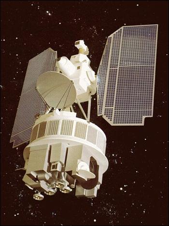
The NASA/GSFC spacecraft was launched Oct. 24, 1978 on a Delta vehicle from VAFB, CA.
Orbit: Sun-synchronous polar orbit, apogee = 954 km, perigee = 941 km, inclination = 99.15º, period = 104.16 minutes, ascending node at 12 noon equator crossing time).
Its sensor complement consisted of the following instruments: 6) 7)
• CZCS (Coastal Zone Color Scanner)
• ERB (Earth Radiation Budget) instrument
• LIMS (Limb Infrared Monitor of the Stratosphere)
• SAM-II (Stratospheric Aerosol Measurement II)
• SAMS (Stratospheric and Mesospheric Sounder)
• SBUV/TOMS (Solar Backscatter Ultraviolet/Total Ozone Mapping Spectrometer)
• SMMR (Scanning Multichannel Microwave Radiometer)
• THIR (Temperature Humidity Infrared Radiometer)
Mission Status
TOMS began taking measurements in December of 1978, and operated nearly continuously until May 1992, thereby producing the longest continual dataset of global total column ozone measurements. The TOMS instrument on Nimbus-7 failed in May 1993.
Sensor Complement (TOMS (Total Ozone Mapping Spectrometer))
TOMS employs the BUV technique which looks directly down at the atmosphere (nadir viewing) to measure the amount of backscattered UV radiation. TOMS was a single Ebert-Fastie spectrometer with a fixed grating and an array of exit slits. TOMS step-scanned across the orbital track ±51º from the nadir in 3º steps with an IFOV of about 0.052 rad. At each scan position, the Earth radiance was monitored at six wavelengths between 310 and 380 nm to infer the total ozone amount. The TOMS completed a cross scan in eight seconds, with one second for retrace, to record 35 scenes per scan. At each scene, a chopper sequentially sampled all six wavelengths four times. TOMS used the same type of PMT (Photomultiplier Tube) detector as SBUV (Solar Backscatter Ultraviolet), and had a separate mercury-argon lamp for wavelength calibration and a separate depolarizer. TOMS shared the diffuser plate with SBUV. Both SBUV and TOMS had five scanner modes and a shared electronics module. Spatial resolution is 3º (scanned through the satellite subpoint and perpendicular to the orbital plane). Swath width = 2700 km.
Note: Backscatter ultraviolet instruments measure the response to solar irradiance by deploying a ground aluminum diffuser plate to reflect sunlight into the instrument. Severe degradation of the Nimbus-7 diffuser plate was observed as time passed, and determining the resultant change of the instrument sensitivity with time proved to be one of the most difficult aspects of the instrument calibration. 8)
Data products: vertical distribution of ozone, global maps of total ozone and 200-mb height fields; incident solar ultraviolet irradiance and ultraviolet radiation backscattered from the Earth. SBUV helps to determine the total amount of atmospheric ozone in a vertical column above the subsatellite point; vertical profile of ozone above the ozone maximum; measurements of ultraviolet solar spectral irradiance and its temporal variability over the 160 - 400 nm range (with a spectral resolution of 1 nm). TOMS exploits the polar orbit to yield global, contiguous maps of total ozone concentrations. 9)
TOMS on the Meteor-3-6 Mission
Launch
The Russian (former Soviet Union) Meteor-3-6 spacecraft was successfully launched on August 15, 1991 (from Plesetsk on a Cyclone launch vehicle ) with a NASA sensor onboard - a refurbished TOMS sensor (the original engineering model for Nimbus-7) was part of this payload (TOMS became in effect the first American-built instrument to fly on a Soviet spacecraft). 10) 11) 12)
The refurbishment of TOMS included also a number of improvements. The diffraction grating was replaced, the mirrors were resurfaced, flight-qualified electronics were added, and a solid state data recorder replaced the tape recorder that had been used for Nimbus-7. Because of the high reliability of the solid state recorder, almost no data were lost during the three year mission. An IAM (Interface Adapter Module) was added to allow the TOMS instrument, which had been designed to work with Nimbus satellites, to operate with Meteor-3-6. It converted the Meteor-3-6 power, commands, clock, telemetry, and data interfaces into a system compatible with TOMS. The most significant change in the instrument was the replacement of the single diffuser plate of Nimbus-7 with a three diffuser system on Meteor-3-6.
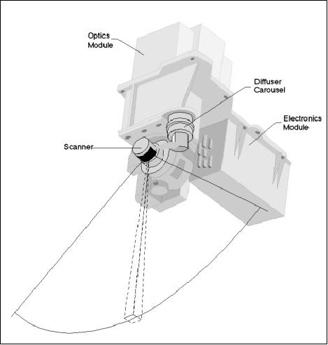
The optics of the two instruments (Nimbus-7 and Meteor-3-6) were identical: a single, fixed monochromator, with exit slits at six near-UV wavelengths. The slit functions were triangular with a nominal 1nm bandwidth. The order of individual measurements was determined by a chopper wheel. As it rotated, openings at different distances from the center of the wheel would pass over the exit slits, allowing measurements at the different wavelengths. The order was not one of monotonically increasing or decreasing wavelength; four samples at each wavelength were interleaved in a way designed to minimize the effect of scene changes on the ozone retrieval. The IFOV of the instrument was 3º x 3º. A mirror scanned perpendicular to the orbital plane in 3º steps from 51º on the right side of spacecraft nadir to 51º on the left (relative to direction of flight), for a total of 35 samples. At the end of the scan, the mirror would quickly return to the first position, not making measurements on the retrace. Eight seconds after the start of the previous scan, another would begin. Consecutive cross scans overlapped, creating a contiguous mapping. TOMS has a swath width of 3100 km. Six spectral bands at: 0.3125, 0.3175, 0.3313, 0.3398, 0.360, and 0.380 µm. The ground resolution is 47 km x 47 km at nadir and 62 x 62 km overall. 13) 14) 15)
TOMS transmitted its data to ground stations in the US and Russia on a daily basis (US archive at GSFC, Russian archive in Dolgoprudny outside of Moscow). The orbital lifetime was projected at two years. Objective: Mapping of vertical ozone profiles.
Orbit of Meteor-3-6: Non-sun-synchronous orbit, perigee of 1195 km, apogee of 1230 km, inclination of 82.5º, period of 109.5 min.
Mission Status
The TOMS instrument on Meteor-3-6 failed to provide operational service after December 27, 1994.
TOMS-EP (TOMS-Earth Probe)
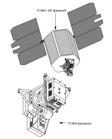
TOMS-EP is a free-flying spacecraft (built by TRW Space & Electronics Group, Redondo Beach, CA) with a payload of the TOMS instrument. It is nadir pointing and provides a contiguous survey of the Earth every day. TOMS-EP is part of NASA's SSTI (Small Satellite Technology Initiative) program. 16) 17) 18) 19)
Spacecraft
The spacecraft bus is of modular design (TRW lightsat bus) with a stowed size of 1.16 m in diameter and 1.77 m in height, three-axis stabilized with a 3σ pointing accuracy of < 0.25º (knowledge) and <0.5º (control). Design life = 2 years, S/C mass = 295 kg (dry mass of 248 kg), power = 130 W. The S/C carries an orbit adjust module which fully integrates the propulsion subsystem (54 kg of propellant). In addition, the S/C features an autonomous operation/redundancy management providing 24 hours of autonomous operation and autonomous safing modes with ground-support recovery. 20)
Launch
A launch of TOMS-EP took place on July 2, 1996 on a Pegasus XL vehicle from VAFB, CA.
RF communications: S-band (Omni-spherical coverage) with an uplink rate of 2 kbit/s and three downlink rates of 1.1 kbit/s, 50 kbit/s, and 200 kbit/s. Onboard storage capacity of 16 Mbit.
Orbit: circular, polar, sun-synchronous, initial altitude = 500 km, inclination = 99.3º, equator crossing time of 12 noon.
Starting Dec. 4, 1997, the TOMS-EP orbit was re-boosted during a 12-day period to an altitude of 750 km. The objective is to: 1) increase the daily coverage, and 2) reach a stable orbit for a period of 4 years. The change in orbit was made necessary by the loss of the ADEOS spacecraft in June 1997.
Mission Status
The TOMS-EP was operational until December 2, 2006 when the backup transmitter failed. All attempts at recovery have failed, including commanding back to the primary transmitter and switching antennas. - The Earth Probe achieved more than 10 years of operational service life, indeed a very successful mission with a design life of 2 years.
• The spacecraft had been operating on the backup transmitter since the primary transmitter failed in April 1998.
• Since there is no more onboard fuel, a controlled reentry cannot be done. NASA estimates a reentry of TOMS-EP in approximately 37 years.
• TOMS-EP mission was decommissioned on May 30, 2007 - thus closing the TOMS program which began with the launch of TOMS Flight Model No. 1 on the Nimbus-7 spacecraft on October 24, 1978. 21) 22) 23)
Sensor complement (TOMS (Total Ozone Mapping Spectrometer))
The TOMS instrument is designed and developed at NASA. The instrument is a second generation backscatter ultraviolet ozone sounder, a nadir-viewing instrument. TOMS can measure ”total column ozone” - the total amount of ozone in a ”column” of air from the Earth's surface to the top of the atmosphere - under all daytime observing and geophysical conditions. TOMS observations cover the near ultraviolet region of the electromagnetic spectrum, where sunlight is absorbed only partially by ozone. TOMS measures ozone indirectly by mapping ultraviolet light emitted by the sun to that scattered from the Earth's atmosphere back to the satellite. Some instrument parameters are:
• Scanning angle in cross-track at ± 55º; IFOV of 3º x 3º, (the TOMS scanner is not pointed at the sun)
• Ebert-Fastie monochromator
• Wavelengths: 308.6 nm, 312.5 nm, 317.5 nm, 322.3 nm, 331.2 nm, and 360.0 nm. The first four wavelengths are absorbed to greater or lesser extents by ozone; the final two are used to assess the reflectivity.
• Ozone trend measurement capacity: 0.1% yearly (goal)
• Swath width: 2700 km (approximately)
• Spatial resolution: nadir - 50 km x 50 km; average: 62 km x 62 km
• Instrument dimensions: 15 x 30 x 27 cm
• Instrument mass: 34 kg; power: 21 W
• Data rate: 600 - 700 bit/s (average). Data is available to the worldwide community of global change researchers through the National Space Science Data Center (NSSDC).
TOMS makes 35 measurements every 8 seconds, each covering 50 to 200 km wide on the ground, strung along a line perpendicular to the motion of the satellite. Almost 200,000 daily measurements cover every single spot on the Earth except areas near one of the poles, where the sun remains close to or below the horizon during the entire 24 hour period.
There is a new on-board calibration system involving illumination of the diffuser plate from a mercury lamp behind a fluorescing screen. - The electronics of TOMS have been modified/updated to include a reprogrammable microprocessor. Side-scanning can now be under the old 35 position mode or in a 37 position mode (used for ADEOS).

TOMS on ADEOS
Launch
A TOMS instrument has been flown on the Japanese ADEOS mission of JAXA (launch Aug. 17, 1996, see ADEOS mission).
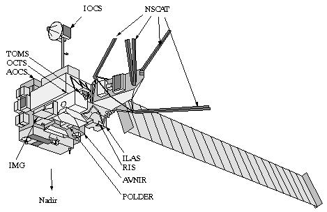
Orbit: Sun-synchronous polar and circular orbit, altitude = 797 km, inclination = 98.6º
Mission Status
TOMS, along with all other payload instruments on ADEOS, failed on June 30, 1997 when the spacecraft suffered several malfunctions and stopped functioning after an apparent loss of power (solar panel failed).
Sensor Compliment (TOMS (Total Ozone Mapping Spectrometer))
TOMS is a NASA/GSFC sensor. Objective: Observation of total column ozone distributions, evaluation of changes in UV radiation and the observation of sulfur dioxide. Measurement wavelengths: 308.6, 312.5, 317.5, 322.3, 331.2 and 360 nm with 1 nm bandpass. Swath width: 2795 km. IFOV= 50 km at nadir; cross-track scan = 111º (37 3º steps). Operation requirements: global observation of illuminated part. TOMS mass=34 kg, power=24 W, data rate=700 bit/s. The instrument flown on ADEOS is shown in Figure 8. 24)
TOMS measures the albedo of the Earth's atmosphere at six narrow spectral bands in the near-ultraviolet region. The albedo is measured by comparing the radiance of the Earth with the radiance of a calibrated on-band diffuser plate. Total ozone is derived from the differential albedo in three pairs of spectral bands, which are selected to function at all latitudes and solar illumination conditions.
TOMS data are available to the worldwide community of global change researchers through the Earth Science Data and Information System (ESDIS) at NASA.
QuikTOMS (Quik Total Ozone Mapping Spectrometer)
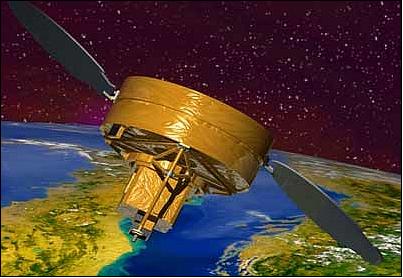
A NASA mission, part of the Earth Explorer program, with the objective to continue long-term ozone measurements with the TOMS instrument beyond the TOMS-EP mission. The TOMS-5 instrument on QuikTOMS was originally scheduled to be flown on the Russian Meteor-3M mission; however, constant delays of the Meteor-3M launch caused NASA to set up an alternate mission to avoid potential coverage gaps. NASA selected OSC of Dulles, VA, as prime contractor for the QuikTOMS mission. That includes S/C provision, sensor integration, launch and two years of mission operations. 25)
Spacecraft
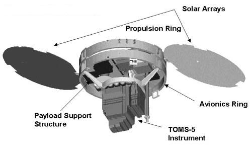
The QuikTOMS spacecraft is a modified MicroStar platform of OSC. The bus is comprised of two rings stacked together vertically a core ring (a dual-faced cylinder consisting of a honeycomb structure) housing all primary spacecraft systems and a payload support module and the second ring carries four propulsion tanks and two solar arrays. The average payload power is 107 W (S/C power of 228 W EOL). Nickel hydrogen (NiH2) batteries provide 10 Ah of energy.
The S/C is three-axis stabilized with pointing control of 0.5º, a pointing knowledge of < 0.25º, and a rate stability of < 0.01º/s. The S/C design life is three years (with consumables of five years). The S/C launch mass is 166 kg.
Launch
A launch of QuikTOMS as a secondary payload to OrbView-4 took place on Sept. 21, 2001 on a Taurus launch vehicle form VAFB, CA. Unfortunately, a Taurus launch vehicle failure caused the loss of both spacecraft. 26) 27)
Communications: The on-board data recorder has a capacity of 64 MByte SSR (Solid State Recorder). S-band communications is used for uplink (2 kbit/s) and downlink (500 kbit/s).
Orbit: Sun-synchronous circular polar orbit, altitude = 800 km, inclination = 98º, descending node equator crossing at 10:30 AM.
Sensor complement (TOMS-5 (Total Ozone Mapping Spectrometer))
TOMS-5 was built by OSC, Pomona, CA (former Perkin Elmer subsidiary bought by OSC). TOMS-5 is a f/5 single grating Ebert-Fastie type monochromator with multiple exit slits for six different wavelengths centered at: 308.6, 312.5, 317.5, 322.3, 331.2, and 360 nm. The nominal bandwidth is 1.2 nm for each band. The wavelength is selected with a chopper wheel near the slit plate which gates the pair of the entrance and exit slits for each wavelength band. IFOV = 3º x 3º or a footprint of about 42 km x 42 km.
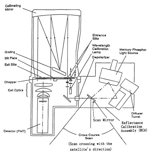
The instrument scans 18 scenes from the nadir to each cross-track direction in a 3º interval to cover a swath of about 2300 km (max scan angle of ±54º, scan cycle time = 6.3 s). The scanning axis of the scanner is 45º from the scanner normal and coincides with the optical axis of the instrument system so that the incidence angle on the scanner mirror is constant regardless of the scan angle. A depolarizer is placed immediately after the scanner mirror to minimize sensitivity to the polarization of the incoming radiation. A baffle with a square opening is placed before the objective lens as an aperture stop and the objective lens images the baffle to the grating. A PMT (Photomultiplier) detector is used for radiation detection.
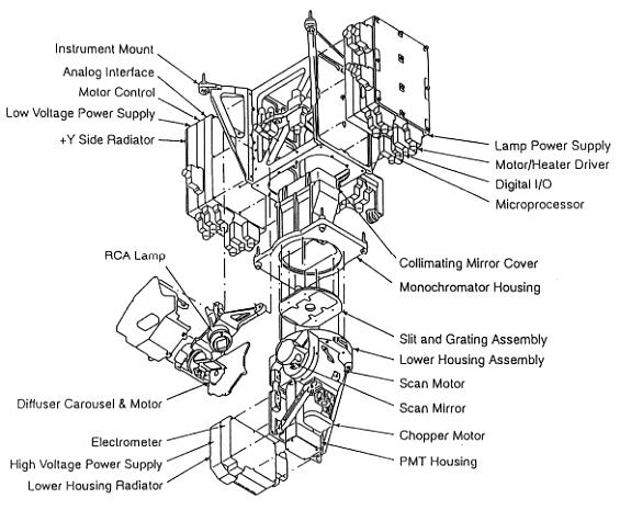
The instrument employs a diffuser assembly to measure the solar flux and uses three onboard calibration features in orbit. The diffuser assembly has three ground aluminum surfaces, one of which is selected for sun illumination at the northern terminator. The diffuser surface generates a radiance source from the solar irradiance and the radiant source fills the field of view of TOMS-5. Two other surfaces are less frequently used for the solar viewing to minimize the degradation.
The wavelength monitor is used to monitor a wavelength shift of the TOMS-5 bands using the mercury 296.7 nm line. Two narrow entrance slits, slightly offset, are imaged over the 312.5 nm exit slit when the 296.7 nm radiation illuminates them. The chopper wheel selects one of the two entrance slit images alternately. Any center wavelength change due to the image shift in the exit plane of the monochromator can be detected by comparing the relative strength of the two alternating signals. The electronic calibration (ECAL) is used to monitor the gain of the electronic amplifiers. A precision current source injects a current at several different levels to the front end of the electronics.
The reflectance calibration (RCAL) is for monitoring the reflectivity of the diffuser surfaces. The Reflectance Calibration Assembly (RCA), a light source for RCA, is made of a mercury pen lamp with a reflector which has a window coated with a mixture of phosphors. This phosphor mixture produces a broad spectral emissions over the TOMS wavelength range when excited by the mercury ultraviolet radiation. The TOMS scanner mirror views the RCA lamp window and the diffuser surface illuminated by the RCA lamp alternately. The relative reflectance of the diffuser surfaces is monitored from the comparison of these two signals.
IFOV (scanner) | 3º x 3º (42 km x 42 km) |
Maximum scan angle, scan cycle time | ±54º, 6.3 s |
Scan dwell time, scan steps | 150 ms, 37 |
Spectral bands: Band 1, Band 2, Band 3 | 360 ±0.1 nm, 331.2±0.1 nm, 322.3±0.1 nm, |
Instrument mass, power | 32 kg, average power is 25 W, peak power is 57 W |
References
1) A. J. Krueger, “The State of Total Ozone Research Before TOMS,” Eos Transactions, AGU, Vol. 84, No 46, Fall Meeting Supplement, A11A-03, 2003
2) “Nimbus-7 TOMS instrument and satellite information,” URL: http://ozoneaq.gsfc.nasa.gov/n7sat.md
3) J. C. Farman, B. G. Gardiner, J. D. Shanklin, “Large losses of total ozone Antarctica reveal seasonal ClOx/NOx interaction,” Nature, Vol. 315, May 16, 1985, pp. 2007-210
4) The possible causes of ozone loss were first pointed out by Paul Crutzen in 1970; he suggested that nitrogen oxides from fertilizers and supersonic aircraft might deplete the ozone layer. In 1974 Frank Sherwood Rowland and Mario J. Molina realized that when CFCs (chlorofluorocarbons) finally break apart in the atmosphere and release chlorine atoms they cause ozone depletion. These three scientists received the Nobel Prize in Chemistry in 1995 for this work.
5) J. F. Gleason, P. K. Bhartia, J. R. Herman, R. McPeters, P. Newman, R. S. Stolarski, L. Flynn, G. Labow, D. Larko, C. Seftor, C. Wellemeyer, W. D. Komhyr, A. J. Miller, W. Planet, “Record Low Global Ozone in 1992,” Science, Vol. 260:, April 23, 1993, pp. 523-526, URL: http://www.ciesin.columbia.edu/docs/011-427/011-427.html
6) http://ozoneaq.gsfc.nasa.gov/
7) “The Nimbus 7 Spacecraft System,” NASA, URL: http://jwocky.gsfc.nasa.gov/n7toms/nimbus7tech.html
8) C. G. Wellemeyer, S. L. Taylor, G. Jaross, M. T. DeLand, C. J. Seftor, G. Labow, T. J. Swissler, R. P. Cebula, “Final Report on Nimbus-7 TOMS Version 7 Calibration,” NASA Contractor Report 4717, National Aeronautics and Space Administration, Washington, DC, 1996
9) Richard D. McPeters, P. K. Bhartia, Arlin J. Krueger, Jay R. Herman, Barry M. Schlesinger, Charles G. Wellemeyer, Colin J. Seftor, Glen Jaross, Steven L. Taylor, Tom Swissler, Omar Torres, Gordon Labow, William Byerly, Richard P. Cebula, “Nimbus–7 Total Ozone Mapping Spectrometer (TOMS) Data Products User's Guide,” 1996, URL: http://jwocky.gsfc.nasa.gov/datainfo/n7usrguide.pdf
10) G. Jaross, A. J. Krueger, R. P. Cebula, C. Seftor, U. Hartman, R. Haring, D. Burchfield, “Calibration and Postlaunch Performance of the Meteor-3/TOMS Instrument,” Journal of Geophysical Research, Vol. 100, 1995, pp. 2985-2995
11) J. R. Herman, P. K. Bhartia, A. J. Krueger, R. D. McPeters, “Meteor-3 Total Ozone Mapping Spectrometer (TOMS) Data Products User's Guide,” 1996, URL: http://toms.gsfc.nasa.gov/datainfo/m3usrguide.pdf
12) “Meteor-3 TOMS instrument and satellite information,” URL: http://ozoneaq.gsfc.nasa.gov/m3sat.md
13) `Soviets to Launch U.S. Ozone Mapper,' Space News Aug. 5-18, 1991, p. 14
14) `TOMS Arrives Successfully in Space,' Space News Aug. 19-25, 1991, p. 2
15) “TOMS Mission Declared Over by NASA Officials,” Space News, February 20-26, 1995, p. 11
16) http://science.nasa.gov/missions/toms/
17) R. D. McPeters, P. K. Bhartia, A. J. Krueger, J. R. Herman, C. G. Wellemeyer, C. J. Seftor, G. Jaross, O. Torres, L. Moy, G. Labow, W. Byerly, S. L. Taylor, T. Swissler, R. P. Cebula, “Earth Probe Total Ozone Mapping Spectrometer (TOMS) Data Products User's Guide,” NASA/TP-1998-206895, November 1998.,
18) http://nssdc.gsfc.nasa.gov/database/MasterCatalog?sc=1996-037A
19) http://public.ccsds.org/sites/databases/Lists/CCSDSProducts/Attachments/8/t100.pdf
20) http://jwocky.gsfc.nasa.gov/eptoms/eptech2.html
21) “NASA Ozone Instrument TOMS Laid To Rest After Three Decades,” Terradaily, Aug. 20, 2007, URL: http://www.terradaily.com/reports/NASA_Ozone_Instrument_TOMS_Laid_To_Rest_...
22) Information provided by Richard D. McPeters of NASA/GSFC, Greenbelt, MD
23) http://jwocky.gsfc.nasa.gov/news/news.html
24) http://suzaku.eorc.jaxa.jp/GLI2/adeos/Project/Toms.html
25) http://www.nasa.gov/centers/goddard/pdf/110908main_FS-2001-5-022-GSFC%20QuickTOMS.pdf
26) “QuikTOMS launch failed to reach orbit,” NASA, URL: http://disc.sci.gsfc.nasa.gov/gesNews/quiktoms-launch-failed-to-reach-orbit
27) “Taurus Launch ends in Failure, QuikTOMS and OrbView-4 Lost,” SpecRef, Sept. 21, 2001, URL: http://www.spaceref.com/news/viewnews.html?id=389
The information compiled and edited in this article was provided by Herbert J. Kramer from his documentation of: ”Observation of the Earth and Its Environment: Survey of Missions and Sensors” (Springer Verlag) as well as many other sources after the publication of the 4th edition in 2002. - Comments and corrections to this article are always welcome for further updates (eoportal@symbios.space).