UARS (Upper Atmosphere Research Satellite)
EO
Atmosphere
Atmospheric Temperature Fields
Radiation budget
Quick facts
Overview
| Mission type | EO |
| Agency | NASA |
| Mission status | Mission complete |
| Launch date | 15 Sep 1991 |
| End of life date | 14 Dec 2005 |
| Measurement domain | Atmosphere |
| Measurement category | Atmospheric Temperature Fields, Radiation budget, Atmospheric Humidity Fields, Ozone, Trace gases (excluding ozone), Atmospheric Winds |
| Measurement detailed | Upward long-wave irradiance at TOA, Downwelling (Incoming) solar radiation at TOA, Atmospheric specific humidity (column/profile), O3 Mole Fraction, Atmospheric temperature (column/profile), CH4 Mole Fraction, NO2 Mole Fraction, Wind profile (horizontal), NO (column/profile), HCl (column/profile) |
| Instruments | SUSIM (UARS), CLAES, MLS, ISAMS, WINDII, PEM, HALOE, SOLSTICE, HRDI, ACRIM II |
| Instrument type | Earth radiation budget radiometers, Magnetic field, Atmospheric chemistry, Atmospheric temperature and humidity sounders |
| CEOS EO Handbook | See UARS (Upper Atmosphere Research Satellite) summary |
UARS (Upper Atmosphere Research Satellite)
UARS is the first NASA mission in the ESE (Earth Science Enterprise) program, formerly known as `Mission to Planet Earth'. UARS is also the first mission dedicated to the study the physical and chemical processes taking place in Earth's upper atmosphere. As such, it represents the first stage of a long-term, international program of space research into global atmospheric change.
The UARS objective is the measurement of energy flux (input and loss) in the upper atmosphere (beginning at about 10-15 km); global photochemistry in the upper atmosphere, in particular in the stratosphere and mesosphere (trace gases and temperature profiles); dynamics of the upper atmosphere; transport phenomena of the different processes; correlations between the upper and lower atmosphere and their changes. 1) 2)
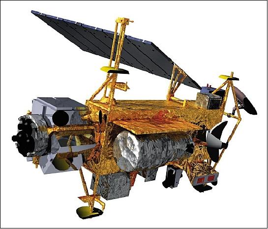
Spacecraft
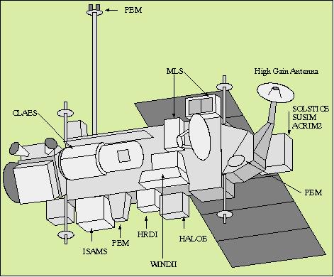
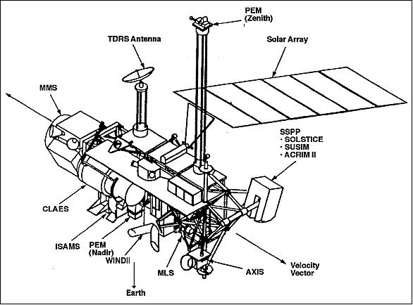
UARS is a free-flying observatory manufactured and integrated by the General Electric Astro-Space Division, Valley Forge, PA and at East Windsor, NJ. The spacecraft has dimensions of about 4.6 m diameter by 10.7 m in length. It is three-axis stabilized via reaction wheels and torque rods (pointing accuracy of 36 arcsec). Attitude knowledge to 20 arcsec using star trackers, Earth sensors, IRU (Inertial Reference Unit), and sun sensors. The single solar array has a size of 1.5 m x 3.3 m, it generates 1.6 kW of power (instrument power of 750 W). In addition there are three 50 Ah batteries for eclipse phase support.
A hydrazine propulsion system is used for orbit insertion and maintenance. The thermal control of the spacecraft is mainly through passive means (paint, blankets, coatings and temperature sensors augmented by electrical heaters). Two instruments, CLAES and ISAMS, have special cooling requirements met by subsystems within the instruments. The nominal design life of the spacecraft is 3 years. The total spacecraft mass is 6540 kg.
The UARS project is managed by GSFC (Goddard Space Flight Center) for NASA's Office of Space Science and Applications. JPL, with collaboration from organizations in the United Kingdom, developed and operate the Microwave Limb Sounder (MLS). 3) 4) 5) 6)
Launch
The UARS spacecraft was launched on Sept. 12, 1991 on the Space Shuttle (Discovery, STS-48; deployment date: Sept. 15, 1991).
Orbit
Non-sunsynchronous near-circular orbit, altitude = 585 km, inclination of 57º, period = 96.7 minutes. This orbit provided an observation coverage of about ±80º in latitude.
RF communications: Telemetry data (32 kbit/s real-time, 512 kbit/s playback) are transmitted via TDRS (Tracking and Data Relay Satellite) to the POCC (Payload Operations and Control center) at GSFC. UARS provided two tape recorders for onboard data storage.
UARS Mission Status
• NASA's decommissioned UARS spacecraft reentered Earth's atmosphere on September 23, 2011. The precise reentry time and location of debris impacts have not been determined. The spacecraft likely broke apart and landed in the Pacific Ocean far off the U.S. coast. The Operations Center for JFCC-Space, the Joint Functional Component Command at Vandenberg Air Force Base, CA, which works around the clock detecting, identifying and tracking all man-made objects in Earth orbit, tracked the movements of UARS through the satellite’s final orbits and provided confirmation of reentry. 7)
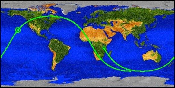
• The UARS spacecraft ceased operations on December 14, 2005 and was decommissioned - providing more than 14 years of operational service (design life of 3 years). The spacecraft will eventually burn up in the atmosphere.
• In the fall of 2004, UARS continued to provide operations with five functioning instruments (HALOE, HRDI, SOLSTICE, SUSIM, and PEM). The observations from HALOE were captured by about 25% of the remaining functioning part of the onboard tape recorder. The observations by the other four instruments were captured only in real-time by using the TDRS. The UARS Flight Operations Team was able to capture up to 60% of these data with the use of three TDRS satellites.
• 2005: The UARS operations were in effect overlapping NASA's Aura mission in the EOS program (launch of Aura July 15, 2004) and providing validation and calibration measurements for the new instruments aboard Aura. It was hoped that UARS would continue operations through the summer of 2005.
• In the summer/fall of 2001, NASA had already definite plans to terminate the UARS spacecraft operations to standby mode to save the annual operating costs (seven of the ten instruments were still operational at the time). However, this proposed action encountered a huge outcry by the atmospheric community and NASA/HQ was asked to continue the mission. NASA managers thus decided to keep UARS going at a much reduced cost (~25% of the previous year's budget). 8)
Sensor Complement
UARS carries ten complementary experiments, each experiment providing measurements critical to our understanding of processes in the upper atmosphere.
• Four instruments (CLAES, ISAMS, MLS, and HALOE) are devoted to measurements of atmospheric constituents.
• Two instruments (HRDI, WINDII) utilize high-resolution interferometry to study upper atmosphere winds by sensing the Doppler shift in light absorbed by or emitted from atmospheric molecules.
• Four investigations (SOLSTICE, SUSIM, PEM, ACRIM-II) obtain estimates of the energy incident on the atmosphere by measuring solar ultraviolet radiation and the flux of charged particles from the Earth's magnetosphere. The UARS solar instruments are mounted on SSPP (Solar Stellar Pointing Platform) that provides tracking of the sun and the stars from the UARS satellite. The SSPP points at the sun during the sun-lit portion of the orbit and it points at stars for SOLSTICE spectral measurements during the dark side of the orbit. The UARS orbit provides about 60 minutes of sunlight in each orbit of which about 35 minutes are available for solar viewing. During this period the SSSPP points the instrument to the center of the sun.
CLAES (Cryogenic Limb Array Etalon Spectrometer)
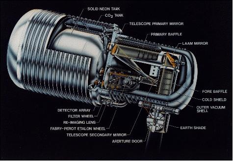
CLAES is a solid-hydrogen cooled spectrometer sensing atmospheric infrared emissions; NASA sensor, (A. E Roche, Lockheed Palo Alto Research Lab). CLAES measures concentrations of members of the nitrogen and chlorine families, as well as ozone, water vapor, methane, and carbon dioxide. To obtain a vertical profile of species concentration, CLAES utilizes a telescope, a spectrometer, and a linear array of 20 detectors to make simultaneous measurements at 20 altitudes ranging from 10 to 60 km. Observables: N2O, NO, NO2, HNO3, CF4, CF2Cl2, CFCl3, HCl, O3, ClONO2, CO2, H2O, ClO, CH4 and temperature. 9) 10) 11)
The CLAES instrument measures trace gases with four Etalons and eight filters in the wave spectrum: 3.5 µm, 6 µm, 8 µm and 12.7 µm. Because the detectors and optics generate their own thermal emissions, they must be cooled to temperatures which suppress this emission. The coolant inside CLAES is expected to be depleted after about 18 months of service. CLAES had a mass of 1,180 kg with dimension of about 1.2 m in diameter and 2.75 m in length.
Operational Status
CLAES ran out of oxygen in May 1993, as planned. It produced a 19-month global database showing the vertical distributions of important ozone-layer gases in the stratosphere and their variation with time of day, season, latitude, and longitude.
ISAMS (Improved Stratospheric and Mesospheric Sounder)
ISAMS is a mechanically cooled spectrometer sensing atmospheric emissions; (PI: F. W. Taylor, Oxford University, UK). This is a SAMS (Stratospheric and Mesospheric Sounder) instrument successor using filter radiometry and pressure modulation techniques in the following ranges: 4.6 - 16.6 µm (medium infrared band). The ISAMS instrument is provided by UK (it is an improved version of SAMS, which operated aboard Nimbus-7 from 1978 to 1983). 12) 13) 14)
ISAMS is a filter radiometer employing eight detectors. It observes infrared molecular emissions by means of a movable off-axis reflecting telescope. In addition to scanning the atmosphere vertically, the telescope can also be commanded to view regions to either side of the UARS observatory, thus providing increased geographic coverage. One feature of ISAMS is that it carries samples of some of the gases to be measured in cells within the instrument. Atmospheric radiation collected by the telescope passes through these cells on its way to the detectors (spectra matching).
The limb-sounding instrument, ISAMS, uses a combination of pressure-modulated and wide-band infrared channels to measure the concentrations of nitrogen chemical species, as well as ozone, water vapor, methane, and carbon monoxide in the middle atmosphere. Typically, ISAMS produces vertical profiles of constituents and temperature every 200 km along the tangent track, with an IFOV of about 2.4 km vertically. Data rate: 1.25 kbit/s. Observables: CO, H2O, CH4, N2O5, NO, N2O, O3, HNO3 and aerosols.
Status
The ISAMS instrument experienced a chopper motor failure in late July 1992, preventing its collection of atmospheric chemistry data.

MLS (Microwave Limb Sounder)
MLS (PI: J. W. Waters, JPL) is a microwave radiometer which measures atmospheric thermal emission from selected molecular lines at mm wavelengths. Three-channel heterodyne limb sounder. Measurement frequencies: 63 GHz (1 band), 183 GHz (2 bands) and 205 GHz (3 bands, corresponding to wavelengths of 4.8, 1.64, and 1.46 mm, respectively). Each band is 500 MHz wide. 15) 16) 17)
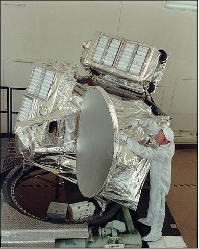
MLS is a microwave radiometer providing global measurements of chlorine monoxide (key reactant that destroys ozone), hydrogen peroxide, water vapor, and ozone. The MLS observations will provide, for the first time, a global data set on chlorine monoxide in the upper atmosphere. MLS also determines the altitudes of atmospheric pressure levels. Spatial resolution in each band: ~400 km horizontal and 4 km vertical; measurement are made along the tangent track of the limb view, with no cross-track scanning, swath width: 5 - 85 km (vertical limb coverage). Observables: O3, ClO, H2O2, H2O and pressure. The overall instrument mass is 280 kg, power consumption is 163 W (max), data rate: 1.25 kbit/s.
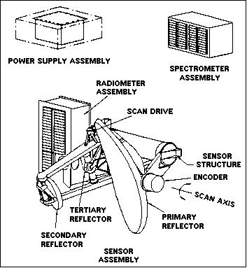
The MLS instrument has three assembly units: spectrometer, power supply, and the main sensor. The sensor includes the scanning antenna, the radiometer box, multiplexing optics, and the calibration system. 18)
The antenna subsystem is a dual-offset Cassegrain consisting of three elliptical reflectors. The primary reflector is an offset paraboloid, 1.6 m x 0.8 m, with a 1 m focal length. The secondary reflector is hyperboloid with dimensions 0.45 m x 0.24 m, and the flat tertiary reflector sends the radiation into the radiometer module. The antenna is scanned in the vertical in discreet steps from about 5 km to 95 km, every measurement cycle has a length of 65.536 seconds.
There are three radiometers in spectral bands centered at 63, 183 and 205 GHz. The 205 GHz radiometer is a single-ended fundamental mount based on the design by Archer and Mattauch with a GaAs Schottky diode. The 205 GHz radiometer measures the signal from the chlorine monoxide/hydrogen peroxide band and ozone band. The 183 GHz radiometer is basically the same as the 205 GHz radiometer. The 183 GHz radiometer measures the signal from the water vapor and ozone bands. The 63 GHz radiometer is a space-qualified commercial mixer- amplifier module using a pair of Schottky barrier diodes. The 63-GHz radiometer measures oxygen to determine atmospheric temperature.
The optical multiplexer separates the radiation from the switching mirror into the three radiometers. The 63 GHz beam is separated with a dichroic plate consisting of equally spaced circular holes in a metal plate. The 183 and 205 GHz beams are separated by a polarization grid of finely spaced wires.
Calibration
Radiometric views of cold space, and an on-board ambient-temperature blackbody target. Calibration stability: better than 1% over mission lifetime. The MLS onboard calibrations are performed by allowing the switching mirror to direct the radiometer FOVs to view both cold space and an internal ambient blackbody calibration target during each limb scan.
HALOE (Halogen Occultation Experiment)
PI: J. M. Russell, NASA/LaRC). The experiment employs the sun occultation technique by using a gas filter radiometer. Infrared range = 2.43 - 10.25 µm. Spatial resolution: vertical = 1.6 km at limb; horizontal = 6.2 km at limb. Measurement of the vertical distribution of hydrofluoric and hydrochloric acids as well as of methane, carbon dioxide, ozone, water vapor, and members of the nitrogen family. The HALOE experiment uses samples of the gases to be observed as absorbing filters in front of the detectors to obtain a high degree of spectral resolution.
HALOE consists of two modules: PEA (Platform Electronics Assembly) and the Sensor Assembly. The PEA links the instrument with the spacecraft. The Sensor Assembly makes the science measurements and consists of eight science detectors and radiometers, a Cassegrain telescope, a two-axis gimbal assembly, a Sun sensor, the spacecraft adapter and supporting electronics. The Cassegrain telescope reflects solar energy through a series of beamsplitters and spectral filters to the photovoltaic detectors for the gas filter correlation channels and to the broadband filter radiometer channels. The atmospheric target gases are detected at specific wavelengths between 2.5 -11 µm. The instrument size is about 92 cm x 62 cm x 81 cm. The PEA size is about 23.5 cm x 24.3 cm x 22 cm. The total mass of the instrument is 101 kg. 19) 20)
During every UARS orbit, at times of S/C sunrise and sunset, HALOE is pointed toward the sun to measure the absorption of energy along this line of sight. There are 28 solar occultation opportunities per day, providing data for 14 different longitudes in each of the northern and southern hemispheres. Data rate = 4 kbit/s. Observables: HF, HCl, CH4, NO, H2O, O3, NO2 and pressure. 21)
Status
The HALOE instrument was commanded to its stow position one last time on November 21, 2005 - providing more than 14 years of operations. 22)
SOLSTICE (Solar/Stellar Irradiance Comparison Experiment)
PI: G. J. Rottman of LASP (Laboratory for Atmospheric and Space Physics), University of Colorado at Boulder. SOLSTICE is a three-channel grating spectrometer for measuring solar and stellar irradiation (UV radiation in the wavelength range from 115 to 430 nm). The three overlapping channels are the G channel from 119 to 190 nm (= 0.1 nm), the F channel from 170 to 320 nm (= 0.25 nm), and the N channel from 280 to 420 nm (= 0.35 nm). 23) 24)
The device compares the ultraviolet output of the sun with similar radiation produced by 30 stable, bright blue stars. The stars constitute the standards against which the solar irradiance is measured.
The experiment consists of a spectrometer with three spectral channels, each with a separate grating and photomultiplier tube. SOLSTICE will be pointed toward the sun during the daylight portion of the orbit, and toward one of the calibration stars during most of the nighttime orbit. Data rate: 250 bit/s.

In solar mode, the solar radiation enters through the spectrometer's entrance slit and then reflects off the first mirror. The radiation is then divided into its many wavelengths by the diffraction grating. The grating rotation is controlled by the grating drive to direct a particular wavelength to the exit slit off the second mirror and ellipsoidal mirror. The ellipsoidal mirror focuses the entrance slit onto the exit slit for the highest possible spectral resolution. The photons are individually detected by the photomultiplier tube (PMT) that looks through the exit slit. The combination of these photon count rates at different wavelengths (by rotating the grating) make a spectrum.
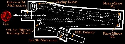
In stellar mode, the stellar radiation follows the same path as the solar radiation; therefore, the trends of the stellar irradiance is directly applicable to solar irradiances. That is, the data from the stable stellar sources determine the instrument degradation rates that are then applied to the solar data. Because the stellar radiation is much dimmer than the solar radiation, the entrance and exit slit sizes are significantly increased as well as the integration time for the data is increased for the stellar observations.
SUSIM (Solar Ultraviolet Spectral Irradiance Monitor)
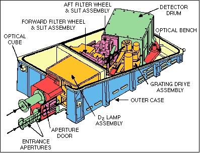
PI: G. E. Brueckner, Naval Research Lab, Washington, DC. SUSIM is a double-dispersion scanning spectrometer which measures solar irradiance (UV radiation in the spectral range from 120-400 nm with a resolution of 0.1 nm). SUSIM incorporates two spectrometers, seven detectors, and a set of four deuterium UV calibration lamps. One spectrometer observes the sun and measures variation in solar UV flux as a function of time. The second spectrometer monitors independently the calibration lamps. Data rate: 2 kbit/s. 25) 26) 27)
Status
SUSIM's daily solar observations began on October 11, 1991 and ended on August 1, 2005.
PEM (Particle Environment Monitor)
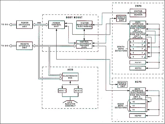
PI: J. D. Winningham, SwRI (Southwest Research Institute), San Antonio, TX. PEM represents a collection of four instruments called
• AXIS (Atmospheric X-ray Imaging Spectrometer)
• HEPS (High-Energy Particle Spectrometer)
• MEPS (Medium Energy Particle Spectrometer)
• VMAG (Vector Magnetometer).
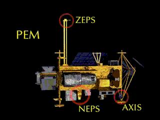
PEM is mounted at three separate locations on UARS, including the boom. Note: ZEPS (Zenith Energetic Particle System), and NEPS (Nadir Energetic Particle System). 28)
AXIS (Atmospheric X-ray Imaging Spectrometer)
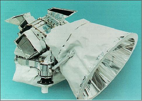
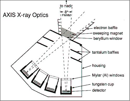
Measurement of Bremsstrahlung X-rays from Earth, solid-state detection. Energy range from 3 keV to 100 keV. Spectral band: 0.012 to 0.41 nm. By continuously remote-sensing these X-rays over a wide area from limb to limb beneath UARS, AXIS provides a "global" monitor of atmospheric energy input. The AXIS data set is thus complementary to the more direct, but localized energy input monitor provided by the PEM particle spectrometers. 29)
HEPS (High-Energy Particle Spectrometer)
Measurement of in situ electron energies from 0.04 MeV to 5 MeV, proton energies from 0.07 MeV to 139 MeV. Measurement technique: solid state identification.
To obtain accurate profiles of atmospheric energy deposition rates from electrons and ions, it is necessary to measure particle fluxes as a function of pitch angle as well as energy. HEPS was designed to provide simultaneous pitch angle measurements with high flux sensitivity (large geometric factor) and fine energy resolution. It achieves these measurements over broad energy and pitch angle ranges. Although the instrument incorporates techniques used previously, it provides unique coverage with the sensitivity and pitch angle resolution that are essential to accomplishing the UARS objectives. 30)
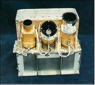
MEPS (Medium Energy Particle Spectrometer)
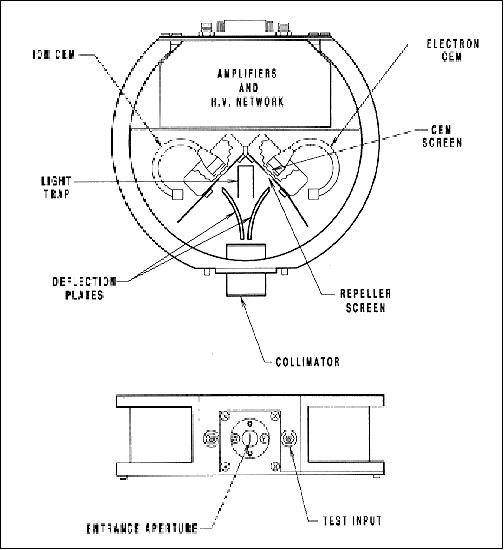
Measurement of electrons and protons. Energy range of electrons: 1 eV - 32 keV, energy range of protons: 1 eV to 32 keV; measurement technique; electric deflection with mechanical separation. MEPS is made up of eight divergent plate electrostatic analyzers similar to those flown in the ISIS and Dynamics Explorer programs. MEPS measures particles that deposit their energy from altitudes of several hundred kilometers down to ~90 km.
To provide an accurate measure of the net energy flux into the upper atmosphere, the analyzers are arrayed such that five of them (the zenith complement) measure down-coming electrons and ions, and three of them (the nadir complement) measure upcoming electrons. The upward-viewing collimators have look directions of -23.7º, 6.3º, 21.3º, 36.3º, and 66.3º with respect to the local upward vertical; the downward-viewing collimators have look directions of -158.7º, 156.3º, 126.3º. All lie in the plane perpendicular to the spacecraft velocity vector. 31)
VMAG (Vector Magnetometer)
VMAG DC: center at 0 nT, width: ±65500 nT. VMAG DC: center at 0 nT with width dependent on AXIS. Measurement of the Earth's magnetic field and the type, number and distribution of charged particles flowing into the upper atmosphere from space. 32)
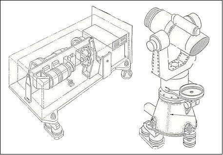
HRDI (High Resolution Doppler Imager)
PI: P. B. Hays, University of Michigan. Objectives: Mapping of atmospheric vector winds at altitudes below 45 km. HRDI observes the Doppler shifts of spectral lines within the atmospheric band system of molecular oxygen to determine the wind field. There are no sharp emissions lines in the radiance of the Earth's limb at such altitudes, but the oxygen bands contain many lines that appear as deep absorption features in the brilliant spectrum of scattered sunlight. 33)
A triple-etalon Fabry-Perot interferometer, serving as a high-resolution spectral filter, ensures efficient rejection of the intense emission continuum outside the absorption lines. HRDI exploits these daytime absorption features to provide wind data for the stratosphere and upper troposphere to an accuracy of 5 m/s or better.
At altitudes above about 60 km, HRDI observes emission lines of neutral and ionized atomic oxygen in the visible and near-infrared regions. Unlike the molecular absorption lines, however, the emission lines are observable both day and night. Mesosphere and thermosphere wind profiles to an accuracy of 15 m/s or better are observed.
Measurement in 13 spectral bands with center wavelength and bandwidth in brackets, all in nm: 557.5 (0.84), 630.0 (.74), 630.5 (1.48), 686.8 (0.88), 687.6 (0.88), 692.3 (1.06), 692.9 (1.36), 723.5 (0.85), 760.7 (0.92), 763.5 (1.45), 764.9 (0.86), 766.6 (1.01), 775.6 (0.93).
The interferometer is tunable within the spectral width and can simultaneously measure 31 samples in a 0.5 cm-1 spectral region at a resolution of 0.05 cm-1. Data rate = 4.75 kbit/s.
WINDII (Wind Doppler Imaging Interferometer)
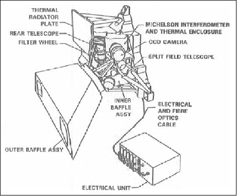
PI: G. G. Shepherd, York University, Canada; Canadian/French instrument, 145 kg mass. WINDII is a field-widened Michelson interferometer measuring the Doppler shift and line broadening of atmospheric emission in the visible and near-infrared. The airglow emissions observed are: O1S at 557.7 nm (green line), O1D at 630 nm (red line), O+ at 732 nm, OH (8,3)P1(3) at 734.1 nm, and O2 Atm (0,0) at 763.2 nm. O+ is observed only on the dayside orbit while OH only during the nightside of the orbit. Measurement of airglow emissions rates and wind conditions in the thermosphere and upper mesosphere. Temperatures in the upper mesosphere are determined from the Rayleigh scattering of sunlight. 34) 35) 36) 37) 38)
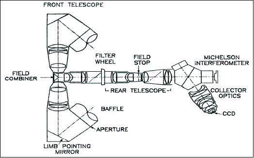
WINDII utilizes emission lines for the basic Doppler-shift measurements. In addition to lines of neutral and ionized oxygen, these include two lines of the OH molecule and a molecular oxygen line. WINDII obtains measurements both day and night at altitudes above 80 km.
The instrument consists of a telescope, the interferometer, and a CCD detector array. The telescope has two fields of view, each 4º x 6º looking at the airglow above the Earth's limb at 45º and 135º from the S/C velocity vector simultaneously. In normal operation, the detector provides a vertical resolution of 20 km. Wind velocity accuracy is within 10 m/s in the altitude range between 80 and 300 km. Data rate: 2 kbit/s. The WINDII spectral filter is a high-resolution Michelson interferometer.
Status
The WINDII instrument provided operations for 12 years (until 2003) and performed flawlessly from the start, surpassing expectations and producing millions of images for scientists.
ACRIM-II (Active Cavity Radiometer Irradiance Monitor)
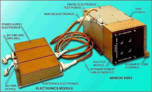
PI: R. C. Willson, Columbia University, New York, NY (ACRIM-II was included on the UARS platform as an instrument of opportunity). The instrument consists of two boxes, the sensor module, mounted on SSPP, and the electronic module, mounted on the S/C bus. In Figure 21, the view illustrates the position of the sensor modules containing the ACR (Active Cavity Radiometer) sensors, the location of the shutter assembly and the position of the sun sensor. The sun sensor provides an independent indication of the angle of the sun to the instrument. The ACRIM-II instrument has a mass of 13 kg. 39)
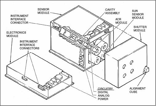
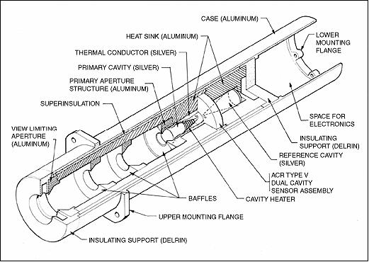
The ACRIM-II instrument consists of three ACRs (Active Cavity Radiometers), type V. The ACRs are electrically self-calibrated pyrheliometers, which are uniformly sensitive from the extreme UV to the far infrared. The principle of measuring total solar irradiance is that the heating effect of irradiant flux on a detector is compared with that of electrical power dissipated in a heating element in intimate thermal contact with the detector. An accurate knowledge of the effective absorptance of the detector for the irradiant flux, the area over which the detector is illuminated and the electrical heating power facilitates the accurate measurement of irradiant fluxes on an absolute basis in the International System of Units. 40) 41)
References
1) http://wwwpem.space.swri.edu/uars-mission-overview.html
2) UARS Project Data Book, April 1987, GE Astro Space Division, URL: https://web.archive.org/web/20150907194049/http://hrdi.engin.umich.edu/generalinfo/Uars_project_data_book.htm
3) J. L. Buckley, “Upper Atmosphere Research Satellite (UARS) - First of the new generation of earth observing satellites,” 43rd IAF, International Astronautical Congress, Washington, DC, Aug. 28-Sept. 5, 1992.
4) “UARS Seen as Earth Observing System's Dress Rehearsal,” Space News September 9-15, 1991, p. 24
5) C. A. Reber, “The Upper Atmosphere Research Satellite,” EOS Transactions, AGU, Vol. 71, 1990, 1867-8, 1873-4
6) Special UARS issue of `Geophysical Research Letters,' June 1993
7) “NASA's UARS Re-enters Earth's Atmosphere,” NASA, Sept. 24, 2011, URL: http://www.nasa.gov/home/hqnews/2011/sep/HQ_11-350_UARS_Re-entry.html
8) Information provided by Charles H. Jackman (UARS Project Scientist) of NASA/GSFC, Greenbelt, MD
9) http://www.spasci.com/CLAES/
10) Portion of a UARS publication put out by NASA (provided by B. Needham of NOAA)
11) “Upper Atmosphere Research Satellite,” Summaries of papers presented at the Optical Remote Sensing of the Atmosphere Topical Meeting, Feb. 12-15, 1990, Optical Society of America, Vol. 4, pp. 1-22
12) http://badc.nerc.ac.uk/data/isams/
13) http://badc.nerc.ac.uk/data/isamsl3/isamshelp.html#description
14) T. J. Nightingale, J. Crawford, “A Radiometric Calibration System for the ISAMS Remote Sounding Instrument,” Metrologia, Vol. 28, No 3, 1991, doi: 10.1088/0026-1394/28/3/025
15) F. Barath, et al., “The Upper Atmosphere Research Satellite Microwave Limb Sounder Instrument,” Journal of Geophysical Research, Vol. 98, 1998, pp. 10751-10762
16) H. C. Pumphrey, H. L. Clark, R. S. Harwood, “Lower stratospheric water vapor measured by UARS MLS,” Geophysical Research, Letters, Vol. 27, No. 12, June 15, 2000, pp. 1691-1694, http://mls.jpl.nasa.gov/joe/pumphrey_etal_grl_2000.pdf
17) http://mls.jpl.nasa.gov/uars/instrument.php
18) http://daac.gsfc.nasa.gov/guides/GSFC/guide/MLS_instrument.gd.shtml#2
19) R. L. Baker, L. E. Mauldin, J. M. Russell III, “Design and performance of the halogen occultation experiment (HALOE) remote sensor,” Proceedings of SPIE, `Infrared technology XII,' San Diego, CA, Aug. 19-20, 1986, pp. 181-191 (A88-12828 02-35)
20) “Halogen Occultation Experiment (HALOE),” NASA, Sept. 1995, URL: http://www.nasa.gov/centers/langley/news/factsheets/Haloe.html
21) J. M. Russell, L. L. Gordley, L. E. Deaver, R. E. Thompson, J. H. Park, “An Overview of the Halogen Occultation Experiment (HALOE) and Preliminary Results,” Advances in Space Research, Vol. 14, No. 9, 1994, pp 9-13
22) http://haloe.gats-inc.com/home/index.php
23) http://lasp.colorado.edu/solstice/uars_design.html
24) G. J. Rottman, et al., “Solar Stellar Irradiance Comparison Experiment 1: 1. instrument design and operation”, Journal of Geophysical Research, Vol.98, 1993, pp. 10667-10678
25) G. E. Brueckner, K. L. Edlow, L. E. Floyd, J. L. Lean, M. E. Van Hoosier, “The Solar Ultraviolet Spectral Irradiance Monitor (SUSIM) Experiment On Board the Upper Atmosphere Research Satellite (UARS),” Journal of Geophysical Research, Vol. 98, p. 10695, 1993
26) http://wwwsolar.nrl.navy.mil/susim_uars.html
27) “SUSIM UARS: An Ongoing Satellite Experiment Measuring the Spectral Composition of Solar Ultraviolet Light,” URL: http://wwwsolar.nrl.navy.mil/susim_uars_nf.html
28) http://wwwpem.space.swri.edu/pem-science.html
29) “The Atmospheric X-ray Imaging Spectrometer ,” SwRI, URL: http://wwwpem.space.swri.edu/axis.html
30) “The High-Energy Particle Spectrometer,” SwRI, URL: http://wwwpem.space.swri.edu/heps.html
31) “Medium-Energy Particle Spectrometer (MEPS),” SwRI, URL: http://wwwpem.space.swri.edu/meps.html
32) “The Vector Magnetometer,” SwRI, URL: http://wwwpem.space.swri.edu/vmag.html
33) “The High Resolution Doppler Imager,” URL: http://hrdi.engin.umich.edu/
34) G. G. Shepherd, G. Thuillier, W. A. Gault, B. H. Solheim, et al., “WINDII - The Wind Imaging Interferometer for the Upper Atmosphere Research Satellite,” Journal of Geophysical Research, Vol. 98, No. 10, 1993, pp. 725-750
35) “Wind Imaging Interferometer (WINDII) for the UARS Mission,” Optical Remote Sensing of the Atmosphere, 1990 Technical Digest Series of the Optical Society of America, Volume 4, pp. PD3-1 to 4
36) W. A. Gault, W. E. Ward, et al., “Optical Doppler Imaging of Atmospheric Winds,” Proceedings of IGARSS'99, Vol. III, Hamburg, Germany, June 28 - July 2, 1999, pp. 1612-1615
37) “Windii To Read Upper Atmosphere In Depth,” Space News September 16-22, 1991, p. 8
38) W. A. Gault, D.-L. Desaulniers, R. H. Hum, D. W. Miller, G. G. Shepherd, W. Ward, J. Wimperis, “Design and on-orbit performance of the WINDII instrument's Michelson interferometer on UARS,” 18th International Symposium on Space Technology and Science, Kagoshima, Japan, May 17-22, 1992. Vol. 1 & 2, A95-82299, pp. 1889-1894
39) http://acrim.jpl.nasa.gov/mission/mission_acrim2.html
40) R. C. Willson, “UARS/ACRIM II Total Solar Irradiance Measurements,” URL: http://www.ngdc.noaa.gov/stp/solar/uars.html
41) http://acrim.jpl.nasa.gov/mission/acrim_explode.html
The information compiled and edited in this article was provided by Herbert J. Kramer from his documentation of: ”Observation of the Earth and Its Environment: Survey of Missions and Sensors” (Springer Verlag) as well as many other sources after the publication of the 4th edition in 2002. - Comments and corrections to this article are always welcome for further updates (eoportal@symbios.space).