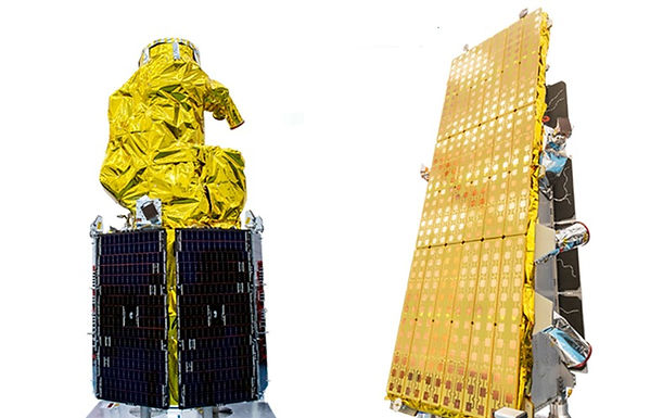
SSTL S1-4 Satellite Vision-1
EO
High resolution optical imagers
Land
Multi-purpose imagery (land)
The Surrey Satellite Technology Limited (SSTL) S1-4 Satellite was launched in September 2018 by Airbus Defence and Space. Data capacity from SSTL S1-4 is leased to several entities, and is also delivered as a sub-1 m imagery service known as Vision-1 used for applications including defence, security, maritime and agriculture.
Quick facts
Overview
| Mission type | EO |
| Agency | ADS |
| Mission status | Operational (nominal) |
| Launch date | 16 Sep 2018 |
| Measurement domain | Land |
| Measurement category | Multi-purpose imagery (land) |
| Measurement detailed | Land surface imagery |
| Instruments | Vision-1 Imagery |
| Instrument type | High resolution optical imagers |
| CEOS EO Handbook | See SSTL S1-4 Satellite Vision-1 summary |
Related Resources
Summary
Mission Capabilities
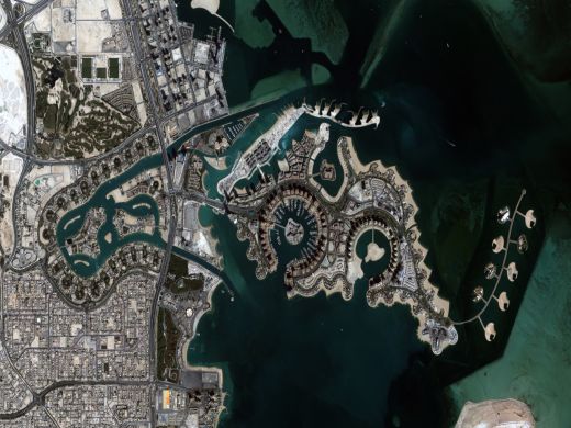
SSTL S1-4 is designed to capture multiple targets in one pass, utilising spot, strip and mosaic imaging modes and 45° off-pointing agility for a range of applications including urban planning, agricultural monitoring, land classification, natural resource management and disaster monitoring.
Performance Specifications
SSTL S1-4 imagery from the Vision-1 service provides imagery in one panchromatic band and four multispectral bands for a 20.8 km swath width at nadir with a spatial resolution of 0.9 m and 3.5 m, respectively. The multispectral bands consist of one near infrared (NIR) band, and three visible bands - red, green and blue.
The SSTL S1-4 Satellite was deployed into a sun-synchronous orbit at an altitude of 583 km and an inclination of 97.5°. It has an Local Time of the Descending Node (LTDN) of 1030 hours with an orbital period of 96.2 minutes. The revisit capacity is one to eight days depending on its latitude.
Space and Hardware Components
The SSTL S1-4 Satellite was built by SSTL, has a mass of 440 kg, and mission design life of seven years.
Overview
Surrey Satellite Technology Ltd (SSTL) S1-4 Satellite provides very high-resolution, sub-metric imagery to support activities in several economic sectors. Imagery is available from Airbus Defence and Space's Vision-1 service offering.
Spacecraft
The SSTL S1-4 Satellite was built and developed by Airbus DS.
Launch
The SSTL S1-4 Satellite was launched on September 16, 2018 alongside NovaSAR on board the Polar Satellite Launch Vehicle from the Satish Dhawan Space Centre in Sriharikota, India.
SSTL S1-4 was deployed into a sun-synchronous orbit at an altitude of 583 km and an inclination of 97.5°. It has an LST of 1030 on a descending node with an orbital period of 96.2 minutes. The revisit capacity is daily to 8 days, depending on the latitude of the area of interest.
Mission Status
Guilford, UK, 26 June 2019 – Airbus enlarged its high-resolution imagery portfolio following an agreement to leverage capacity from the S1-4 satellite built by Surrey Satellite Technology Limited (SSTL). This new imagery offer called can Vision-1 deliver full end-to-end imaging operations to Airbus’ customers.
Sensor Complement
The sensor is a Newtonian telescope, combined with a complex pick-off prism & folded refractive relay with Focal length 6.666 m, corrected across-track Field of View (FoV) of ± 1.1°, 42 cm primary mirror, and an f- number of 15.9.
Spectral Band | Spectrum Wavelengths (nm) | Spatial Resolution (m) | Swath Width (km) |
Panchromatic | 450 - 650 | 0.9 | 20.8 (at nadir) |
Near Infrared | 760 - 910 | 3.5 3.5
| |
Red | 600 - 670 | ||
Green | 510 - 590 | ||
Blue | 440 - 510 |
The viewing angle is ±30°in roll for standard viewing mode and ±45° in roll for extended viewing mode. Pointing agility has roll/pitch 60° within 85 seconds excluding stabilisation time. Location accuracy at nadir is less than 12 m CE90. Dynamic range at acquisition is 10 bits per pixel.
The mission is designed for a lifetime of minimum 7 years.
Vision-1 is designed to capture multiple targets in one pass, utilising spot, strip and mosaic imaging modes and 45 degree off-pointing agility for a range of applications.
Imagery can be acquired in three different modes:
- Strip Mode (Mono): Images are acquired in pushbroom fashion at a range of view angles up to 45° off-nadir. Acquired strips of variable length are divided into individual tiles of approximately 465 km2 (at nadir).
- Stereo Mode: currently under development, provides two co-incident image scenes acquired at opposing pitch angles of ±30° in the along-track direction.
- Area Mode: currently under development, imagery is acquired over a square footprint with almost double the natural swath of the instrument, either side of nadir in the along and across track directions and stitched together.
There are two radiometric processing levels:
The initial raw measurement performed by the satellite is converted to a radiance value (via the sensor calibration). This can then be converted to 'Top-Of-Atmosphere' (TOA) reflectance as measured from space, thus considering the reflectance measurement as filtered by the atmosphere.
TOA reflectance may be further corrected to consider the transfer of reflected light through the atmosphere to obtain direct spectral information at the ground level. This is known as 'Bottom-Of-Atmosphere' (BOA) or 'Top-Of-Canopy' (TOC) reflectance.
The two different geometric processing levels are:
Projected: The product is mapped onto the Earth cartographic system using a standard reference datum and projection system at a constant terrestrial altitude, relative to the reference ellipsoid. By default, the map projection system is WGS84/UTM. The image is georeferenced without the application of a Digital Elevation Model (DEM) and supplied with the RPC model file. Pansharpened are not available as projected products.
Standard Ortho: georeferenced image in Earth geometry, including the application of a Airbus World DEM for Ortho and GCPs (using Airbus Intelligence One Atlas BaseMap as reference). The orthorectification procedure eliminates the perspective effect on the ground (excluding buildings) to restore the geometry of a vertical shot.
Data Access
Through ESA’s Third Party Missions programme, Vision-1 data products are delivered on a free basis to a range of stakeholders, supporting application development and enabling cutting-edge scientific research. Vision-1 is also an active satellite in the International Disasters Charter, collaborating with other data providers and enabling users on the ground to access vital data in times of need. ESA is offering scientific research and application development, access to a full archive and new acquisition data from the Vision-1 mission. This is dependent upon acceptance of a submitted proposal.
References
1) “ESA - Earth observation image of the week.” European Space Agency, https://www.esa.int/ESA_Multimedia/Sets/Earth_observation_image_of_the_week/(result_type)/images.Accessed 11 October 2022
2) “Vision-1.” Engesat, http://www.engesat.com.br/wp-content/uploads/r54485_9_vision-1-flyer-31072019.pdf. Accessed 24 October 2022.
3) “Vision-1 | Ideal High-Resolution Monitoring Solution.” Airbus Intelligence, https://www.intelligence-airbusds.com/imagery/constellation/vision1/. Accessed 24 October 2022.
4) ESA - Earth Online, European Space Agency: https://earth.esa.int/eogateway/missions/vision-1/overview.