WCOM (Water Cycle Observation Mission)
EO
Planned
CAS
The Water Cycle Observation Mission (WCOM) has been selected in the space science program of CAS (Chinese Academy of Science) to observe soil moisture, ocean surface salinity, snow water equivalence and freeze/thaw. These observations will help research associated with Earth’s systems, ecosystem and society. WCOM is set to launch by 2030.
Quick facts
Overview
| Mission type | EO |
| Agency | CAS |
| Mission status | Planned |
Summary
Mission Capabilities
WCOM will have three instruments onboard: IMI (Interferometric Microwave Imager), PMI (Polarimetric Microwave Imager) and DPS (Dual-frequency Polarised Scatterometer). IMI is a tri-frequency radiometer for soil moisture and sea salinity observation, while PMI is a multifrequency microwave radiometric imager for collecting the radiation from the Earth surface to retrieve the geophysical parameters of the land, ocean and atmosphere. DPS is a dual frequency polarised radar scatterometer for snow water equivalence and freeze/thaw observation.
Performance Specifications
IMI has a mean spatial resolution of 15-50 km while PMI and DPS have mean spatial resolutions of 4-50 km and 2-5 km, respectively. IMI has a sensitivity of 0.1-0.2 K while PMI and DPS have a sensitivity of 0.3-0.5 K and 0.5 dB. WCOM will have a swath width of over 1000 km with a revisit time of 2-3 days, while following a sun-synchronous orbit at an altitude of 645 km.
Space and Hardware Components
WCOM will have a total mass of 1300-1500 kg with an instantaneous data rate of approximately 27 Mbps. The daily data volume is 291.6GB with 750 Mbps downlink data rate, and the total data downlink time is about 52 minutes per day. The ground segment of the WCOM mission includes the ground support system and science application system.
Overview
The Chinese Water Cycle Observation Mission (WCOM) was proposed and selected as one of the candidate missions for advanced studies in the space science program of CAS (Chinese Academy of Sciences). The implementation of WCOM expects significant improvement in the observation capabilities and understanding of the responses and feedbacks of water cycle to global change. The proposal for the WCOM satellite is under the support by the “Strategic Priority Research Program for Space Sciences” of the Chinese Academy of Sciences. 1) 2) 3) 4) 5)
Background
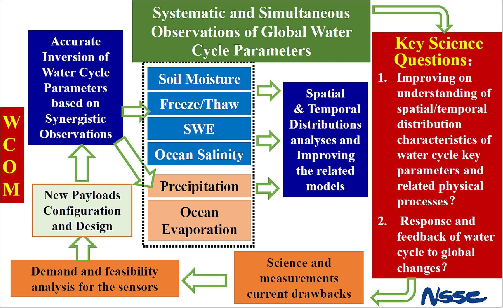
The water (hydrological) cycle is the most active and important component in global mass and energy circulation of the Earth system. The existence, transport, and change of water in the atmosphere, land (surface and underground) and oceans play very important roles in the Earth system, ecosystem and human society. The responses and feedback (causes and consequences) of the water cycle to global change are one of the key questions in the field of Earth science. Observations and modelling are the essentials of water cycle and global change research, especially the retrieval of parameters based on satellites with fine spatial and temporal resolutions and accuracies.
So far, many satellite missions have been developed which are (and have been) providing important contributions to research of the water cycle and of global change. These satellite missions are providing important data about different aspects of the hydrological cycle, such as Aqua for evaporation; TRMM and GPM for vertical structure and distribution of precipitation; SMOS, Aquarius and SMAP for soil moisture and ocean salinity; and GCOM-W for ocean surface evaporation, snow, ice and soil moisture. Furthermore, the series of meteorological satellites developed by the US, Europe, China and other countries can also provide useful information about the water in the atmosphere.
However, the existing capabilities for spaceborne observations of the temporal and spatial distributions of global water cycle variables are still quite limited, especially under the complex conditions of the land. The main inadequacies include:
- lack of spatially and temporally synchronous observations of water cycle variables which are required by the model assimilation under systematic equilibrium conditions
- lack of simultaneous and synergetic measurements of both the main determining parameters and auxiliary environmental parameters which are required for accurate retrieval
- insufficient radiometric, spatial and temporal resolutions to meet the requirements for accurate retrieval.
The WCOM mission was jointly proposed by SKLRSS (State Key Laboratory of Remote Sensing Science) in the Institute of Remote Sensing and Digital Earth, Chinese Academy of Sciences (RADI, CAS) and MiRS in NSSC (National Space Science Center) of CAS. The Co-Principal Investigators (PIs) of the mission are Xialong Dong and Jiancheng Shi, both of SKLRSS. 6) 7)
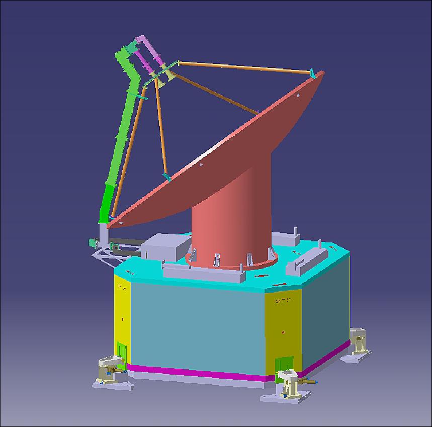
Spacecraft
The power and mass requirements of the WCOM mission consist of those from the payloads and satellite platform. Table 3 lists the preliminary requirements of power.
Subsystem | Power Requirement (WATT) |
|
| Long-Time | Short Time |
Thermal Control | 50 | 30 |
Attitude Control | 70 | 40 |
Power Supply | 50 |
|
TC/TM | 25 |
|
Housekeeping | 25 |
|
Data Transfer | 30 | 280 |
Platform Total | 250 | 220 |
IMI | 250 |
|
PMI | 250 |
|
DFPSCAT | 800 |
|
Payload Total | 1300 |
|
Grand Total | 1550 | 220 |
The mass budget includes the main platform weighing in at 800 - 900 kg along with the payloads having a total mass of 500 - 600 kg, split between: IMI (250 - 300 kg), PMI (200 - 250 kg), and DPS (approximately 100 kg). This leaves a total mass of 1300 - 1500 kg.
Preliminary analysis about the total data volume shows that the instantaneous data rate of WCOM is about 27 Mbps: IMI: 5 Mbps for IMI, 2 Mbps for PMI and 20 Mbps for DFPSCAT. The daily date volume is 291.6GB. With 750 Mbps downlink data rate, the total data downlink time is about 52 minutes per day.
A preliminary analysis had been done for the data downlink capability. By using the three domestic ground stations located in Beijing, Sanya and Urumqi, there will be a daily downlink time of about 102 minutes. Once the currently under construction Arctic ground station has been completed, there will be a daily downlink time of about 93 minutes. Both situations can satisfy the data requirements. 14)
Launch
Launch is planned by 2030. The satellite will launch into a sun-synchronous dawn/dusk orbit at 06:00 hours at an altitude of 645 km.
Mission Status
- May 2018 - WCOM is currently under engineering phase.
- December 2015: WCOM is subjected to the PDR (Preliminary Design Review) to enter Phase-B.
- February 2015 - three from 8 candidate missions were selected as the key support missions with full funding for 2014-2015. WCOM is one of them.
- 2014 - 2015: Phase-A of project study and requirements of key technologies
- July 2013 - WCOM was selected as one of 8 candidate missions - to be launched around 2020.
Sensor Complement
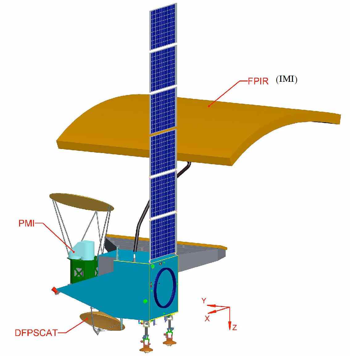
WCOM will be dedicated to the significant improvement of global hydrological science by systematic and simultaneous observations for water cycle variables, which is implemented by accurate inversion based on synergetic observations. There will be three main payloads for water cycle parameter observations:
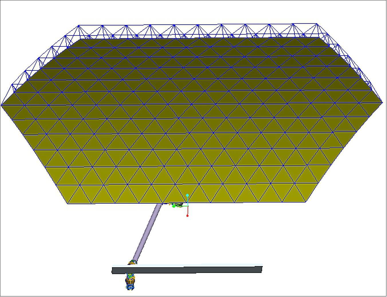
• IMI (Interferometric Microwave Imager): A tri-frequency (L-/S-/C-band) radiometer with a resolution of 15 - 50 km for soil moisture and sea salinity. It is a interferometric synthetic aperture radiometer with a 6 m x 6 m reflector and a one-dimensional thinned array.
• PMI (Polarimetric Microwave Imager): A multifrequency (6.8 to 150 GHz) microwave radiometric imager. It features a mechanically scanned reflector antenna for wide swath and unfocused SAR for higher resolution.
• DPS (Dual-frequency Polarised Scatterometer): A dual-frequency polarised radar scatterometer with 2 - 5 km resolution and a swath of 1000 km for snow water equivalence and frozen/thaw. It is a mechanically scanned radiometer with a 1.8 m diameter reflector antenna.
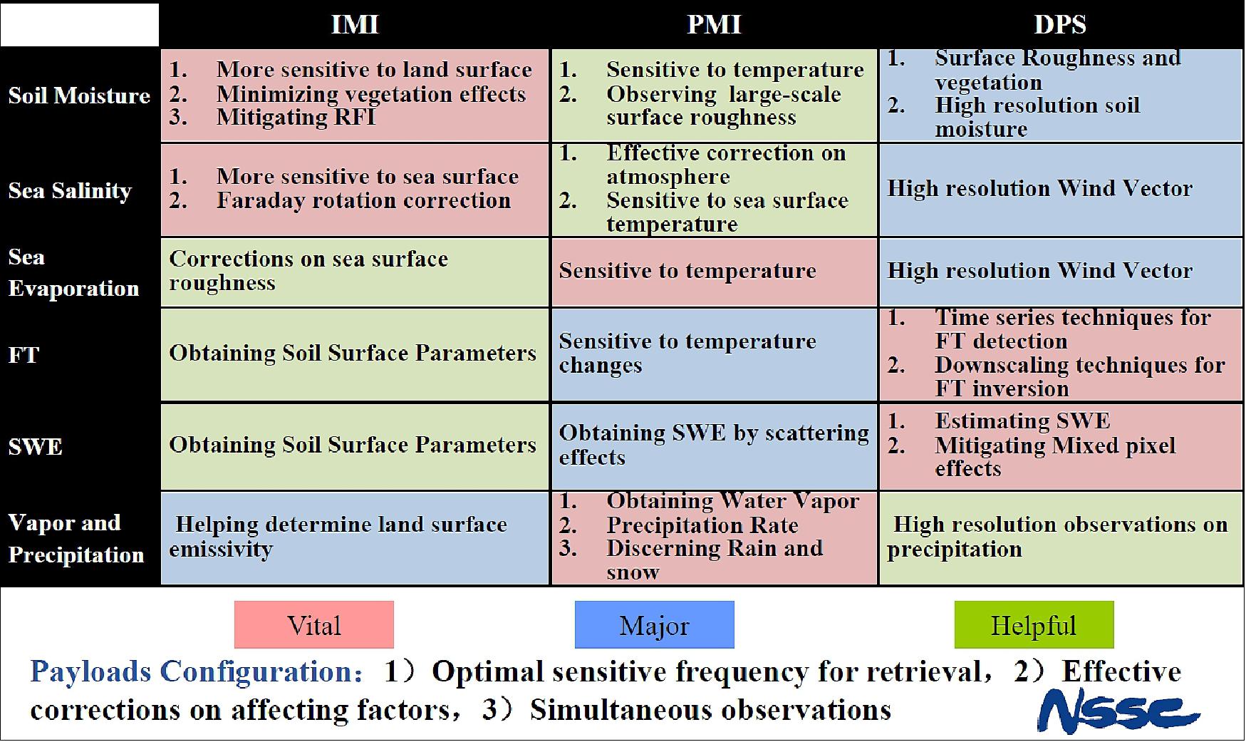
The tentative contributions of these payloads to the observation of water cycle variables are listed in Table 2. The main specifications of the payloads are listed in Table 3.
Parameter | IMI | PMI | DPS |
Soil moisture | - L band BT sensitive to soil moisture - Minimising vegetation effects by S-band BT - Mitigating RFI by combined L/S | - Sensitive to physical temperature - Observing large-scale surface roughness | - 1 Surface Roughness and vegetation - 2 high resolution soil moisture |
SSS (Sea Surface Salinity) | - L-band BT sensitive to SSS - Faraday rotation correction | - Effective atmospheric correction - Sensitive to sea surface temperature | - High resolution wind vector |
Sea surface evaporation | - Corrections for sea surface roughness | - Sensitive to physical temperature | - High resolution wind vector |
Freeze/thaw | - Soil surface parameters | - Sensitive to temperature changes | - Time series techniques for FT detection - Downscaling techniques for FT inversion |
Snow water equivalence | - Soil surface parameters | - Obtaining SWE by scattering effects | - Estimating SWE by simultaneous surface and volume scattering |
Vapour and precipitation | - Help for determination of land surface emissivity | - Water vapour content - Precipitation rate - Discerning rain and snow | - Improving resolution for precipitation observation |
Parameter | IMI | PMI | DPS |
Frequencies | L-, S-, C-band | 6.8, 10.65, 18.7, 23.8, 37, 89, 150 GHz | X-band, Ku-band |
Mean spatial resolution | 15~50 km | 4~50 km | 2~5 km |
Swath width | >1000 km | > 1000 km | > 1000 km |
Sensitivity | 0.1~0.2 K | 0.3~0.5 K | 0.5 dB |
Polarisation mode | Full-polarisation | Full-polarisation for selected frequencies | Full-polarisation |
Temporal resolution | 2-3 days | 2-3 days | 2-3 days |
IMI (Interferometric Microwave Imager)
IMI is a tri-frequency interferometric synthetic aperture radiometer with a 9 m x 6 m mesh reflector. The objective is to provide an advanced measurement capability on soil moisture and ocean salinity parameters from space. L-band radiometry has been identified as a most effective tool to measure these two parameters from space. 8) 9)
For WCOM, a new instrumentation approach has been adopted by IMI to implement the L-band spaceborne radiometer, using a one-dimensional interferometric radiometer with parabolic cylinder reflector antenna. One motivation of this design is to balance the system complexity and system performance, the other is to include additional higher frequencies (S and C band) in a single system to provide more information for soil moisture and ocean salinity measuring. A payload with similar configuration but with additional L-band scatterometer and different frequencies for radiometer, named MICAP (Microwave Imager Combined Active and Passive), has also been selected as a candidate for future Chinese ocean salinity satellite missions.
The IMI antenna is mainly composed of the deployable parabolic cylinder mesh reflector and the tri-frequency (L/S/C) linear patch feed array. Although the reflector is relatively large because of the L-band working frequency, a better spatial resolution can be achieved by using a mesh reflector.
The L/S/C tri-frequency feed array arrangement is very important to the imaging quality of this one-dimensional synthetic aperture radiometer system. The size of the antenna array limits the feed distances and the number of feeds. The shortest adjacent feed distance is set to be 0.13 m after considering the aliasing in the field of view and the size of the feed device. Due to the constraints of design size parameters of the antenna device, the number of antenna feeds is too many. In such a case, several feed array arrangements are obtained using a genetic simulated annealing algorithm. In order to improve the sensitivity performance, some elements from the feed array are chosen to be replaced by larger ones, whose sizes are doubled.
Parameter | L-band | S-band | C-band |
Frequency (GHz) | 1.4135 | 2.695 | 6.9 |
Bandwidth (MHz) | 25 | 8 | 200 |
Number of elements | 12 | 12 | 14 |
Along-track resolution (km) | 35 | 20 | 10 |
Cross-track resolution (km) | 35-75 | 20-45 | 15-30 |
Radiometric resolution (K) | 0.2 | 1.5 | 0.6 |
FOV (Field of View) (km) | 1000 | 1000 | 1000 |
WCOM adopts aperture synthesis technology to implement the large antenna size for L-band. Unlike the L-band two-dimensional interferometric radiometer MIRAS carried onboard ESA’s SMOS mission, or the L-band real aperture radiometer used onboard NASA’s Aquarius mission, IMI is an L/S/C tri-frequency 1D interferometric radiometer which consists of the deployable 6 x 9 m parabolic cylinder mesh reflector and the tri-frequency patch feed array. 10) 11) 12)
As a 1D interferometric radiometer, IMI has a lower system complexity compared with the two-dimensional interferometric radiometers, which allows for higher stability and calibration accuracy in orbit than IMI. On the other hand, compared to the real aperture system, IMI can achieve better spatial resolution and a wider observation swath.
The motivation of the design to include the additional higher frequencies, S- and C-band, is mainly for the soil moisture observation, which can also provide more information for salinity and sea surface temperature.
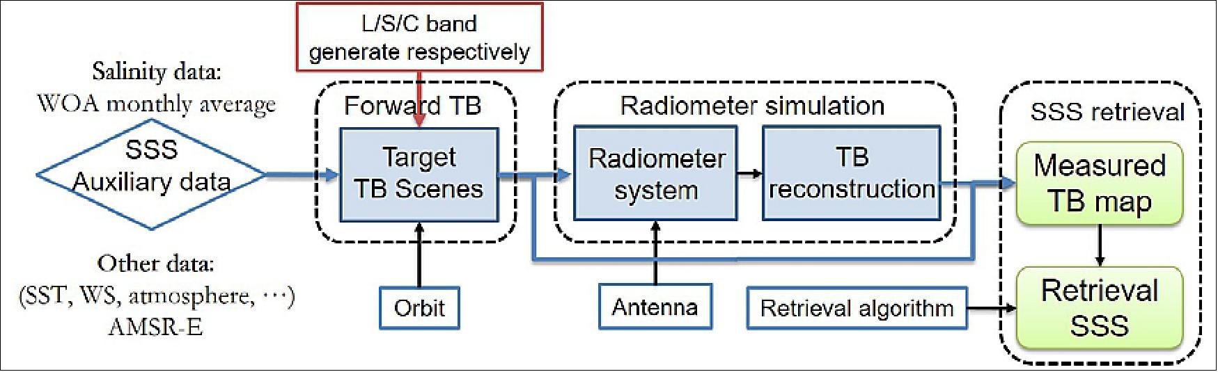
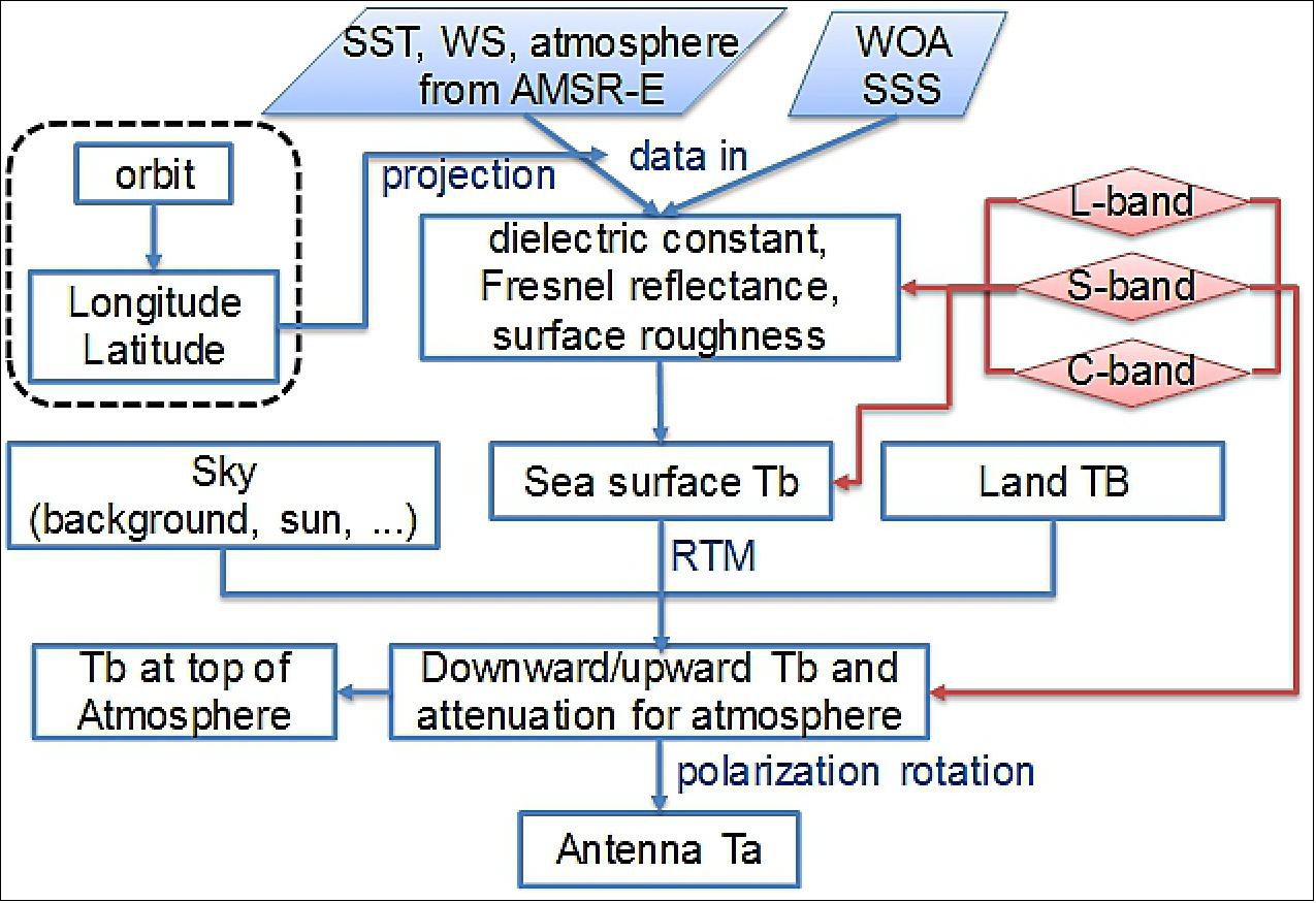
The end-to-end simulation for ocean salinity is based on the previous work of the one-dimensional interferometric radiometer IMI simulation system and the sea radiometer transfer model used in Li et al. “Land Contamination Analysis of SMOS Brightness Temperature Error Near Coastal Areas” (13), and it is built on the Matlab platform.
The end-to-end simulation flow is shown in Figure 5, which begins with the input salinity from World Ocean Atlas (WOA) monthly averaged data and ends with the retrieval SSS from the simulated measured Brightness Temperature (TB). The other geophysical data used in the simulation like sea surface temperature, atmosphere and wind are from AMSR-E.
PMI (Polarimetric Microwave Imager)
PMI is a multi-frequency conically scanning radiometric imager. It’s technical specifications include:
• Reflector dimension: 1.8 m
• Multi-frequency capability (6.8/7.2-90 GHz)
• Full-polarimetric capability for surface imaging (10.7, 18.7, 37 GHz)
• Width swath: >1000 km
• Calibration: on-board two-point
• Stowed antenna during launch and deploy after in orbit
Frequency (GHz) | Bandwidth (MHz) | Polarisation | Radiometric Resolution (K) | Spatial Resolution (along-track x cross-track (km) |
6.8/7.2 | 350 | V, H | 0.3 | 53 x 31 |
10.7 | 300 | Full | 0.4 | 34 x 19 |
19.1 | 750 | Full | 0.3 | 19 x 11 |
23.8 | 500 | V, H | 0.5 | 15 x 9 |
37.0 | 2000 | Full | 0.3 | 10 x 6 |
90 | 2000 | V, H | 0.5 | 4 x 2 |
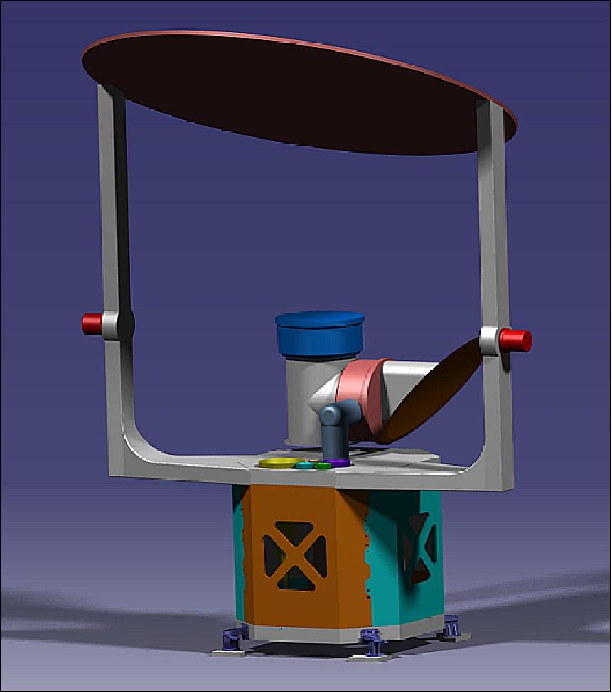
DPS (Dual-frequency Polarised Scatterometer)
DPS is a rotating pencil-beam radar scatterometer. It’s technical specifications include:
• X-Ku dual-frequency polarised (HH, VV, HV/VH)
• Rotating pencil-beam for higher antenna gain and SNR (cross-polarization)
• Dual frequency share the reflector
• Antenna aperture dimension: approximately 1.5 m to adapt to the launch contour and scanning loss
• Co-polarization and cross-polarization
• Spatial resolution:
- Elevation: 15 km
- Azimuth: 50 m
Frequency | 9.6 GHz, 17 GHz |
Bandwidth | 5 MHz |
Swath | > 1000 km |
Peak power | 200 W/150 W |
Polarisation | HH, VV, HV, VH |
Antenna aperture | 1.5 m x 1.5 m |
Incident angle | ~39º |
Sigma 0 (σ0) range | HH, VV: +15~-25 dB HV,VH: +5~-35 dB |
Sigma 0 precision | 0.5 dB |
Raw resolution | 50 m (azimuth) x 15 km (elevation) |
Reconstructed resolution for SWE (Snow Water Equivalent) | 2 - 5 km |
Ground Segment
The ground segment of the WCOM mission includes the ground support system and science application system. The ground system consists of ground station subsystem (GSSS), mission operation subsystem (MOSS) and data processing and management subsystem (DPMSS). GSSS includes ground stations operated by the Institute of Remote Sensing and Digital Earth of Chinese Academy of Sciences (RADI), MOSS and DPMSS are operated by the National Space Science Center of Chinese Academy of Sciences (NSSC). The science application system will be organised by the science team of the WCOM mission, where the chief scientist plays a leading role.
Three domestic ground stations located in Beijing, Sanya and Urumqi will be used which allows for a daily downlink time of about 102 minutes. Once the currently under construction Arctic ground station has been completed, there will be a daily downlink time of approximately 93 minutes with the four ground stations. Both situations can satisfy the data requirements.
References
1) ”Synergetic Observations of the Water Cycle,” International Space Science Institute, Beijing, November 20-21, 2014, URL: http://www.issibj.ac.cn/Program/Forums/WCOM/201403/t20140328_118607.html
2) Jiancheng Shi, Xiaolong Dong, Tianjie Zhao, Jinyang Du, Lingmei Jiang, Yang Du, Hao Liu, Zhenzhan Wang, Dabin Ji, Chuan Xiong”WCOM: The science scenario and objectives of a global water cycle observation mission,” Proceedings of IGARSS (IEEE Geoscience and Remote Sensing Society) 2014, Québec, Canada, July 13-18, 2014
3) Xiaolong Dong, Hao Liu, Zhenzhan Wang, Jiancheng Shi, Tianjie Zhao, ”WCOM: The mission concept and payloads of a Global Water Cycle Observation Mission,” Proceedings of IGARSS (IEEE Geoscience and Remote Sensing Society) 2014, Québec, Canada, July 13-18, 2014
4) ”WCOM: a new Chinese satellite mission for studies of the global water cycle,” https://web.archive.org/web/20160919234203/http://eo-water.radi.ac.cn/en/highlight_detail.php?id=1
5) Jiancheng Shi, Xiaolong Dong, Tianjie Zhao, Jinyang Du, Hao Liu, Zhenzhan Wang, Di Zhu, Dabin Ji, Chuan Xiong, Lingmei Jiang, ”The water cycle observation mission (WCOM): Overview,” IGARRS, Beijing, China, 10-15 July 2016, https://web.archive.org/web/20231114200246/http://ieeexplore.ieee.org/document/7729886
6) Xialong Dong, Jiancheng Shi, ”Water Cycle Observation Mission (WCOM) and Its Potentials for Ocean Surface Wind Vector Measurement,”IOVWT (International Ocean Vector Winds Team) Meeting, Royal Netherlands Meteorological Institute, 2-5 May 2017, URL: https://mdc.coaps.fsu.edu/scatterometry/meeting/docs/2017/docs/Tuesday/morning/SecondSession/1108_WCOM_IOSVWST201705.pdf
7) Jiancheng Shi, Xiaolong Dong, Tianjie Zhao, Jiyang Du, Lingmei Jiang, Hao Liu, Zhenzhan Wang, Dabin Ji, and Chuan Xiong, ”A Water Cycle Observation Mission (WCOM).” The 29th SSG meeting of the WCRP/GEWEX”, 6-9 February, 2017, Sanya, China, URL: https://www.gewexevents.org/wp-content/uploads/SSG29_Jiancheng_Shi_WCOM.pdf
8) Hao Liu, Lijie Niu, Lin Wu, Cheng Zhang, Xiangkun Zhang, Xiaobin Yin, Ji Wu, ”IMI (Interferometric Microwave Imager): A L/S/C Tri-Frequency Radiometer for Water Cycle Observation Mission (WCOM),” Proceedings of IGARSS (International Geoscience and Remote Sensing Symposium), Beijing, China, July 10-15, 2016
9) Aili Zhang,, Hao Liu, Ji Wu, Lin Wu, Xue Chen, ”Quantitative evaluation of linear feed array of interferometric synthetic aperture microwave imager on WCOM,” Proceedings of IGARSS (International Geoscience and Remote Sensing Symposium), Valencia, Spain, July 23-27, 2018
10) Yan Li, Hao Liu, ”An end-to-end simulation of ocean salinity using L/S/C tri-frequency radiometer for water cycle observation mission (WCOM),” Proceedings of IGARSS (International Geoscience and Remote Sensing Symposium), Valencia, Spain, July 23-27, 2018
11) Yan Li, Hao Liu and Aili Zhang, ”End-to-End Simulation of WCOM IMI Sea Surface Salinity Retrieval,” Remote Sensing, MDPI, 22 January 2019, https://www.mdpi.com/2072-4292/11/3/217
12) Panpan Yao, Jiancheng Shi, Tianjie Zhao, Michael H.Cosh , Rajat Bindlish and Hui Lu, ”An L-band Brightness Temperature Disaggregation Method using S-band Radiometer Data for the Water Cycle Observation Mission (WCOM),” NASA, URL: https://ntrs.nasa.gov/api/citations/20190029130/downloads/20190029130.pdf
13) Yan Li, Qingxia Li, Hailiang Lu, ”Land Contamination Analysis of SMOS Brightness Temperature Error Near Coastal Areas,” IEEE Geoscience and Remote Sensing Letters, Volume 14, Issue: 5, May 2017, DOI: 10.1109/LGRS.2016.2637440
14) X. Dong et al., "Preliminary design of water cycle observation mission (WCOM)," 2016 IEEE International Geoscience and Remote Sensing Symposium (IGARSS), Beijing, China, 2016, pp. 3434-3437, doi: 10.1109/IGARSS.2016.7729887.