WorldView-4
EO
Mission complete
Maxar
WV110
Launched in November 2016, WorldView-4 was the fifth high-resolution imaging satellite to be operated by DigitalGlobe - a commercial company that has since been acquired by Maxar Technologies. WorldView-4 went out of action in January 2019, after its orientation was unable to be controlled.
Quick facts
Overview
| Mission type | EO |
| Agency | Maxar |
| Mission status | Mission complete |
| Launch date | 11 Nov 2016 |
| End of life date | 07 Jan 2019 |
| Instruments | WV110 |
| CEOS EO Handbook | See WorldView-4 summary |
Related Resources

Summary
Mission Capabilities
WorldView-4 had on board the SpaceView-110 Camera (WV110), also used by its predecessor WorldView-3, which provided the highest resolution satellite imagery commercially available at the time. Whilst available commercially, WorldView-4 imagery was also provided to intelligence analysts, defence officials, and other important decision-makers. For the most part, satellite imagery is provided to these parties whilst part of a Direct Access Program (DAP). This allows them to directly task and download imagery from all of Maxar’s satellites.
GeoEye originally designed the satellite and named it GeoEye-2. Following the merge of GeoEye with DigitalGlobe, the satellite was renamed WorldView-4. DigitalGlobe was later acquired by Maxar on 5 October, 2017.
Performance Specifications
WV110 has five spectral bands: one panchromatic and four multispectral. The panchromatic band has a bandwidth that ranges 0.45 - 0.8 µm (which covers all visible light) and a resolution of 0.31 m. The multispectral bands are blue, green, red, and NIR and they all possess a resolution of 1.24 m when viewing the nadir. The swath width is 13.1 km.
WorldView-4 is in a sun-synchronous orbit with an altitude of 617 km and an orbit period of 97 min.
Space and Hardware Components
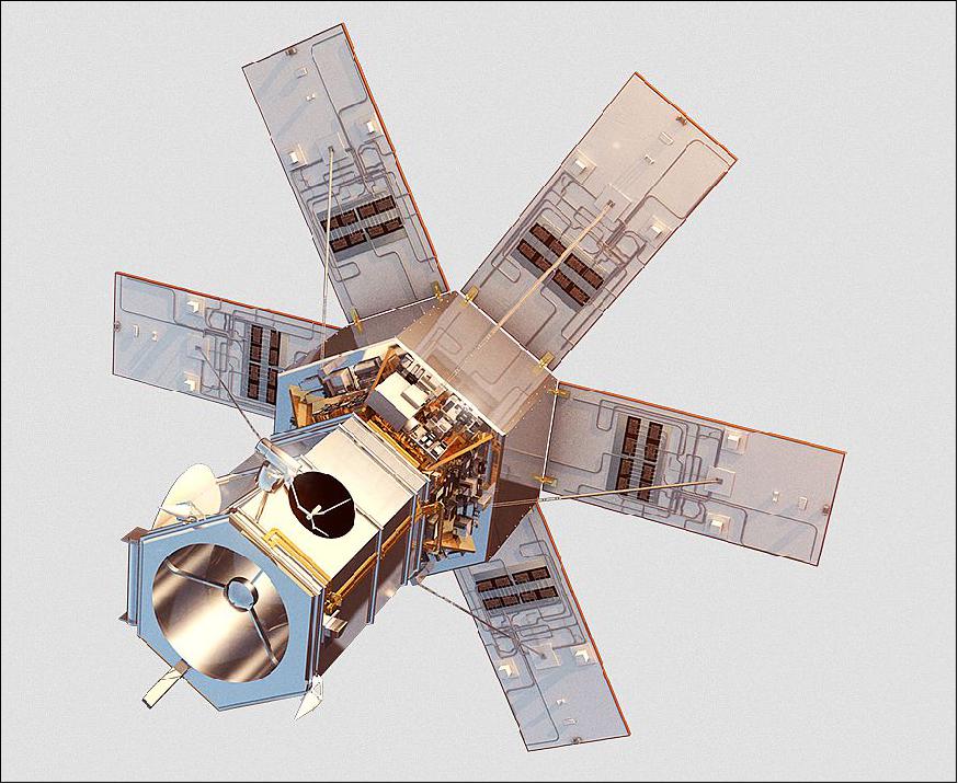
The LM-900 acted as the spacecraft bus for the WorldView-4. It contained a star tracker and precision IRU (Inertial Reference Unit) to determine its orientation, control moment gyroscopes (CMGs) to alter its orientation, and a GPS receiver to determine its position in space.
In January 2019, the CMGs experienced a failure that prevented WorldView-4’s orientation to be adjusted which prevented the collection of further imagery.
WorldView-4 (formerly GeoEye-2)
Spacecraft Launch Mission Status Sensor Complement References
In June 2014, Digital Globe announced that it received notice from the U.S. Department of Commerce on its application to allow the company to sell its highest-quality and industry-leading commercial satellite imagery. Effective immediately, DigitalGlobe was permitted to offer customers the highest resolution imagery available from their current constellation. Additionally, the updated approvals will permit DigitalGlobe to sell imagery to all of its customers at up to 0.25 m panchromatic and 1.0 m multispectral GSD (Ground Sample Distance) beginning six months after its next satellite WorldView-3 is operational. The launch of Worldview-3 is scheduled for August 2014. 1)
With the launch of WorldView-3, the DigitalGlobe constellation will set a new technological bar for commercial satellite imagery, offering customers the highest available resolution, revisit rate, capacity, and spectral diversity. The company currently operates a fleet of five high-resolution earth imaging satellites. Two of those satellites — GeoEye-1 and WorldView-2 — collect imagery sharper than 0.50 m, and all customers will have access to that imagery at the highest native resolution. WorldView-3 will provide even higher resolution at 0.31 m, and the GeoEye-2 satellite, which is substantially complete, will capture similarly sharp images when it is launched to replace a satellite currently in service or as an expansion to the constellation once warranted by market demand.
Some background on the GeoEye-2 / Worldview-4 development program 2) 3) 4) 5) 6) 7) 8) 9) 10) 11)
• GeoEye-2 is a third generation commercial satellite optical imaging mission of GeoEye Inc., Dulles, VA, USA. In January 2009, GeoEye awarded a contract to ITT Geospatial Systems of Rochester, N.Y. to start work on the imager for the GeoEye-2 spacecraft. 2)
• The requirements of GeoEye call for a spatial resolution of 25 cm of its imagery. Under current licensing constraints, only U.S. Government customers and specifically designated allies have access to imagery at this highest resolution while commercial customers receive imagery at the highest resolution allowed by U.S. regulations, currently at 0.5 m GSD (Ground Sample Distance).
• In March 2010, GeoEye Inc. awarded a contract to Lockheed Martin Space Systems to build the company's next-generation, high-resolution Earth imaging satellite system known as GeoEye-2. 3)
• In August 2010, NGA (National Geospatial-Intelligence Agency) awarded a contract, referred to as SLA (Service Level Agreement), to GeoEye within its Enhanced View program. The contract deals with the purchase of satellite imagery and includes also an NGA cost share for the development and launch of the GeoEye-2 spacecraft. Operational services of GeoEye-2 are scheduled for 2013. 4) 5)
• In early December 2010, GeoEye-2 successfully completed the program's Preliminary Design Review (PDR). 6)
• In January 2012, GeoEye-2 passed the system CDR (Critical Design Review).The spacecraft features CMGs (Control Moment Gyros) to provide an optimum of pointing agility for all observation modes. 7)
• DigitalGlobe and GeoEye merged on January 31, 2013 to become one company, DigitalGlobe. On February 4, 2013, DigitalGlobe announced that its previously planned satellite construction program related to its third WorldView-class satellite remains on track. 8)
• In August 2014, DigitalGlobe announced its plans to accelerate the launch of WorldView-4, previously named GeoEye-2, to mid-2016 to meet demand from DigitalGlobe's Direct Access and other commercial customers. 9)
• DigitalGlobe launched its WorldView-3 spacecraft on August 13, 2014 to meet the requirements of its EnhancedView contract with the U.S. government. WorldView-3 offers the most spectral diversity available commercially and it is the first satellite to offer multiple short-wave infrared bands that allows for accurate imaging through haze, fog, dust, smoke and other airborne particulates. 10)
• In Dec. 2015, MDA (MacDonald , Dettwiler and Associates Ltd.) announced that it has signed a multi-million dollar contract with DigitalGlobe Inc. to provide multiple international ground stations with upgrades to receive and process imagery and data directly from DigitalGlobe's WorldView-4 satellite, in addition to the company's existing satellite constellation. After its planned launch in September 2016 , WorldView-4 will deliver multi-spectral high resolution optical imagery. 11)
Spacecraft
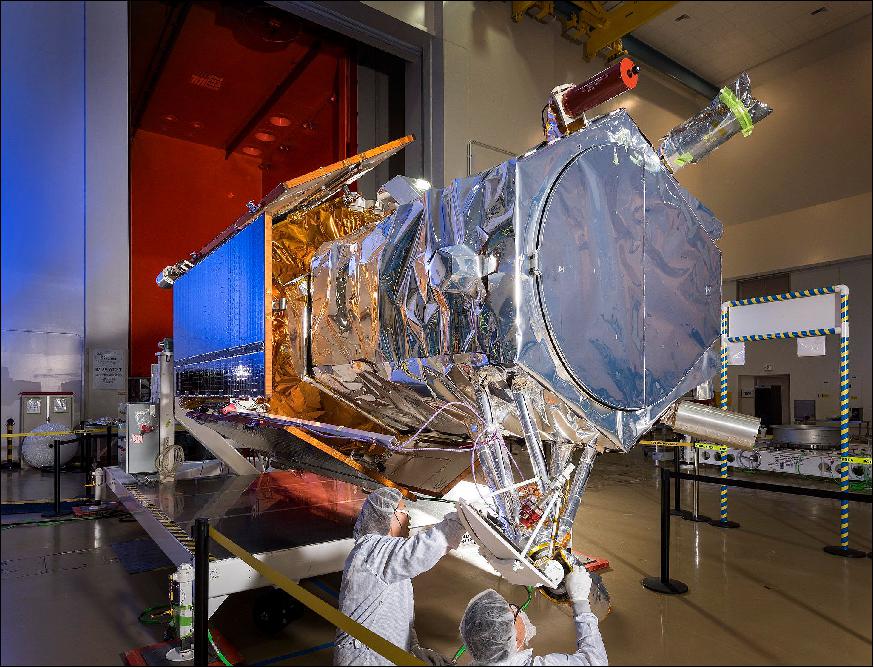
WorldView-4 will be DigitalGlobe's next very high resolution imaging satellite providing high resolution and color imagery to commercial, government and international customers. Lockheed Martin is the prime contractor of the WorldView-4 spacecraft. WorldView-4 will provide map-accurate images with a new, high-resolution camera provided by Harris Corporation. In addition to delivering critical geospatial situational awareness and global security information to intelligence analysts, war fighters and decision makers, commercial users will also benefit from access to imagery from WorldView-4. The satellite is fully integrated, tested and ready for launch call-up. 12)

Spacecraft bus | LM-900 |
Spacecraft mass | 2,087 kg |
Spacecraft size | 5.3 m tall x 2.5 m across; 7.9 m across with deployed solar panels |
Design life | 7 years, (estimated service life: 10-12 years) |
ADCS (Attitude Determination and Control Subsystem) | - 3-axis stabilization |
Retargeting agility | Time to Slew 200 km: 10.6 sec |
Onboard storage capacity | 3200 Gbit solid state memory with EDAC |
Communications | - X-band downlink for image & ancillary data at 800 Mbit/s |
Max contiguous area collected in a single pass (30º off-nadir angle) | - Mono: 66.5 km x 112 km (5 strips) |
Revisit frequency (at 40º N latitude) | - 1 m GSD: < 1.0 day |
Geolocation accuracy (CE90) | Predicted <4 m CE90 without ground control |
Observation capacity | 680,000 km2 per day |
Development Status
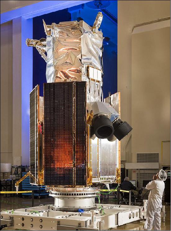
• August 15, 2016: WorldView-4, which weighs 2,500 kg and stands 5.5 m tall, is "a big telescope with a little satellite wrapped around it," said Walter Scott, founder, chief technical officer and executive vice president of Westminster, Colorado-based DigitalGlobe. 14)
- WorldView-4 has taken an unusually long time to get to the launch pad. Lockheed Martin began building the satellite, originally named GeoEye-2 for GeoEye of Herndon, Virginia, in 2010. After DigitalGlobe and GeoEye merged in 2013, DigitalGlobe proceeded with its planned launch of WorldView-3 and opted to store GeoEye-2. DigitalGlobe renamed the GeoEye-2 satellite WorldView-4 in 2014 when the company announced its 2016 launch.
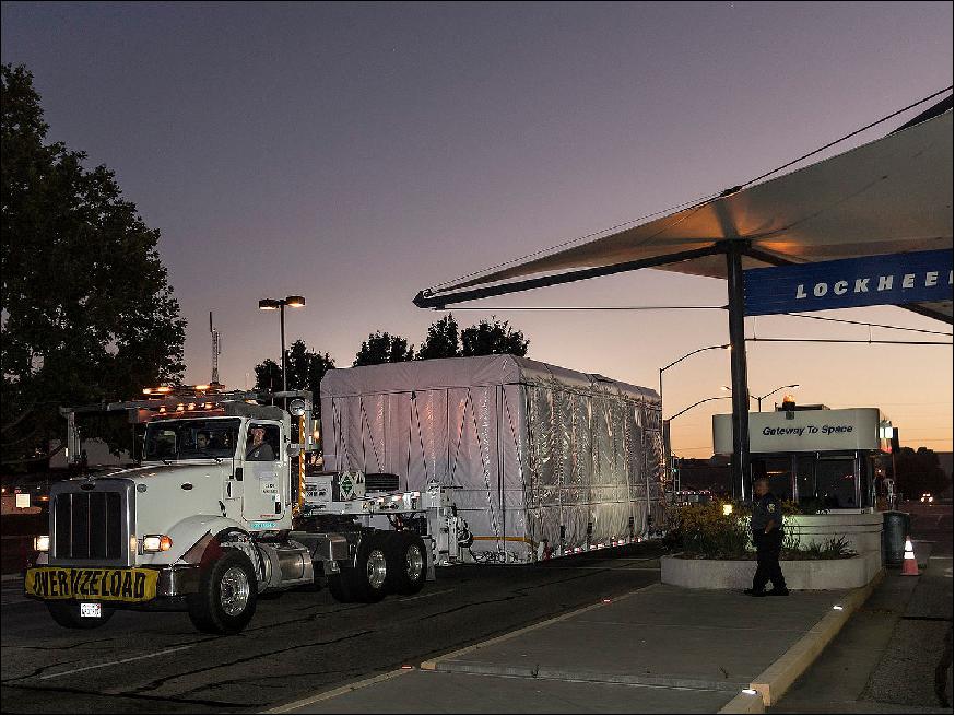
• On July 28, 2016, the WorldView-4 satellite arrived at VAFB after a 250-mile trip (from Sunnyvale, CA) in a cleanroom-on-wheels. The Lockheed Martin-built WorldView-4 was transported by truck in a special container that mimics the environment of the cleanroom where the satellite was manufactured. 15)
- Prior to shipping, the satellite passed a full suite of environmental, functional and performance tests and was declared ready for integration with the rocket that will carry it to an altitude of 617 km in space.
Launch
The WorldView-4 (former GeoEye-2) spacecraft was launched on November 11, 2016 (18:30 UTC) on an Atlas-V 401 vehicle of ULA (United Launch Alliance) from VAFB, CA, SLC-3E (Space Launch Complex-3East). 16) 17) 18)
The launch of WorldView-4 had to be cancelled on the original launch date of September 18 due to an extremely aggressive fire that consumed some 12,000 acres (4840 hectare) across Vandenberg's South Bases. This was considered to be the largest fire in the base's history but, fortunately, the space launch complexes and other facilities remained clear of the destruction. — All of the 200 miles of cabling have now been certified as in order by the 30th Space Communications Squadron of the US Air Force, and all appears to be a "go" for this delayed and now re-scheduled launch (Ref. 18).
Orbit: Sun-synchronous orbit, altitude = 617 km, inclination = 98º, period = 97 minutes, LTDN (Local equatorial crossing Time on Descending Node) at 10:30 hours, effective revisit time capability ≤ 3 days.
Secondary Payloads 19)
DigitalGlobe has included a CubeSat rideshare program. The CubeSats will be launched by the use of ULA's Centaur Aft Bulkhead Carrier which has flown successfully on four previous Atlas V missions. All of the 7 CubeSats manifested for the WorldView-4 mission are sponsored by the U.S. NRO (National Reconnaissance Office) and are unclassified technology demonstration programs. DigitalGlobe is also partnering with California Polytechnic State University, Tyvak Nanosatellite Systems Inc., Lockheed Martin and United Launch Alliance to bring this rideshare program to fruition.
Tyvak Nanosatellite Systems (Irvine, CA) served as the integrator for all seven CubeSats. ENTERPRISE is the fifth mission to utilize ridesharing, but the first in which the organization has partnered with a commercial company to do so. 20)
• CELTEE-1 (CubeSat Enhanced Locator Transponder Evaluation Experiment-1), a 1U CubeSat built by M42 Technologies (Seattle, WA) for AFRL (Air Force Research Laboratory). The goal is to test the performance of an ELT (Enhanced Location Transponder) in support of SSA (Space Situational Awareness).
• Prometheus-2 x 2, two 1.5U technology demonstration CubeSats (Block 2) of LANL (Los Alamos National Laboratory). Test of communications between remote field sites and ground station terminals in a store-and-forward environment.
• AeroCube-8C and -8D, two 1.5U technology demonstration CubeSats of the Aerospace Corporation (El Segundo, CA) to test electric propulsion, CNT (Carbon Nanotubes) and solar cell technology.
• U2U (Untitled 2U), a 2U CubeSat of AFRL to demonstrate the EGM (Electron and Globalstar Mapping) experiment.
• RAVAN (Radiometer Assessment using Vertically Aligned Nanotubes), a 3U CubeSat mission funded by NASA and developed and operated by JHU/APL.
The CubeSats will be deployed after WorldView-4 separation as part of the NRO-sponsored ENTERPRISE mission.
Mission Status
• May 6, 2019: Maxar Technologies has announced that the company's insurance carriers have accepted the company's $183 million claim for loss arising from the WorldView-4 satellite on-orbit failure and have agreed to pay the company that full amount under their insurance policies. 21)
- Insurance proceeds have already been received from several insurers and full payment is expected to be delivered within 30 days. Maxar will use the proceeds to invest in its pre-existing capital priorities, including the development of its innovative WorldView Legion constellation.
- The operations of DigitalGlobe, SSL and Radiant Solutions were unified under the Maxar brand in February; MDA continues to operate as an independent business unit within the Maxar organization.
• January 7, 2019: Maxar Technologies Inc. today reported that its WorldView-4 satellite experienced a failure in its CMGs (Control Moment Gyros), preventing the satellite from collecting imagery due to the loss of an axis of stability. 22)
- Efforts are ongoing in conjunction with its suppliers in an attempt to restore satellite functionality, but thus far these efforts have been unsuccessful. At this time, Maxar believes that WorldView-4 will likely not be recoverable and will no longer produce usable imagery. Maxar operations has put the WorldView-4 satellite in a safe configuration and will continue to monitor the satellite's location and health. The satellite was built by Lockheed Martin and the CMGs was provided by Honeywell.
- WorldView-4 was acquired by GeoEye prior to its merger with DigitalGlobe in 2013. It was launched in November 2016 and generated revenues of approximately $85 million in the fiscal year 2018. The satellite had a net book value of approximately $155 million, including related assets, as of December 31, 2018. If the satellite is not recoverable, then the net book value will be written off in Q4-2018. Contingency planning and mitigation efforts are underway to assess the use of the Company's other satellites and outside resources to replace imagery collected by WorldView-4 and meet as much of the existing customer commitments and obligations as possible. The Company currently believes it will be able to offset $10 to 15 million of the annual revenue from WorldView-4 and will work to minimize the potential impact on Maxar's financial results in future years.
- The WorldView-4 satellite is insured for $183 million, and Maxar intends to seek full recovery for the loss of WorldView-4 under its insurance policies. The Company will provide further updates on this matter as new information becomes available.
• October 04, 2018: NASA has launched a pilot program to evaluate how Earth science data from commercial small-satellite constellations could supplement observations from the agency's fleet of orbiting Earth science missions. On 28 September, the agency awarded sole-source contracts to acquire test data sets from three private sector organizations. 23)
- NASA's Earth Science Division in Washington issued blanket purchase agreements for the "Private Sector Small Constellation Satellite Data Product Pilot" program. Under these agreements, the agency purchases data sets and related products based on observations derived from Earth-orbiting, small-satellite constellations designed and operated by non-governmental entities.
- "This pilot program is an innovative and efficient way for us to acquire, examine, and evaluate a wide range of private sector Earth observation data," said Michael Freilich, director of NASA's Earth Science Division. "As our very capable NASA research satellite fleet ages and more small satellites are launched by private industry, there are opportunities to leverage the strengths of each into even more complete climate data sets."
- NASA will provide the test data products to NASA-funded researchers, who will examine whether the data help advance the agency's science and applications development goals. The pilot program is designed to determine whether these private sector observations and associated products offer a cost-effective means to augment or complement the suite of Earth observations acquired directly by NASA, other U.S. government agencies, and international partners.
- The contracts were awarded to:
1) DigitalGlobe, a Maxar Technologies company headquartered in Westminster, Colorado, has five very high-resolution Earth imaging satellites (GeoEye-1, WorldView-1, WorldView-2, WorldView-3, WorldView-4) capable of collecting 30 cm resolution imagery.
2) Planet, headquartered in San Francisco, has three satellite constellations (SkySat, Dove, RapidEye) with more than 150 satellites supplying imagery and derived products over the entire Earth at medium and high resolution with high repeat frequencies.
3) SPIRE Global, headquartered in San Francisco, operates a constellation of over 60 Lemur 3U CubeSats collecting radio occultation soundings, aircraft location information and ship reports. GPS radio occultation measurements can be used to sound the atmosphere for temperature, water vapour, and atmospheric pressure.
- These contracts represent the first time that NASA has engaged with commercial small-satellite constellation operators to purchase their data for scientific evaluation. They establish a way for NASA to acquire and examine the data products during the next 12 months. Each contract includes an option for NASA to extend the agreement for an additional four years, for a total value of up to $7 million for each of the three agreements.
- To be considered for participation in this pilot program, companies had to demonstrate they were currently operating a small satellite constellation of no fewer than three satellites in non-geostationary orbit and producing consistent global coverage. Companies also were asked to supply a comprehensive catalogue of their data, describing areal coverage, data latency, pricing, and other factors.
- NASA uses the vantage point of space to understand and explore our home planet, improve lives and safeguard our future. The agency's observations of Earth's complex natural environment are critical to understanding how our planet's natural resources and climate are changing now and could change in the future.
• April 22, 2018: DigitalGlobe, a Maxar Technologies company, formerly MDA (MacDonald, Dettwiler and Associates Ltd.), announced today that with the complete integration of DigitalGlobe's WorldView-4 satellite imagery into SecureWatch, the company's powerful, cloud-based geospatial intelligence (GEOINT) platform, customers can now access more of the world's highest resolution satellite imagery. 24)
- WorldView-4's daily imagery collections more than double SecureWatch's daily volume of valuable 30 cm imagery, enhancing defense and intelligence analysts' ability to closely monitor activity in their areas of interest. WorldView-4 collection plans are constantly analyzed and improved to deliver more refreshed 30 cm imagery over the rapidly changing geographies that SecureWatch customers need to make mission-critical decisions with confidence.
- The subscription-based platform will expand further this summer when RADARSAT-2 imagery from MDA, another Maxar company, becomes available. MDA's RADARSAT-2 SAR (Synthetic Aperture Radar) imagery will expand the capacity for analysts to monitor key locations around the world, regardless of weather and light conditions.
- When layering radar and optical imagery together, an analyst can quickly flag areas of change and develop richer situational reports. The planned addition of MDA's RADARSAT-2 imagery into DigitalGlobe's SecureWatch product is yet another example of how Maxar is extending cross-business technology to accelerate innovation and offer integrated solutions to customers.
- "The combination of RADARSAT-2 imagery and DigitalGlobe's optical imagery, with the other enriched data sources within SecureWatch, will create powerful solutions for analysts to maintain situational awareness and achieve mission success no matter what's happening on the planet," said Jeff Kerridge, Senior Vice President and General Manager of DigitalGlobe International Defense and Intelligence.
- DigitalGlobe also celebrates the signing of its 20th SecureWatch defence and intelligence agency customer since launching the product in February 2017. The first 10 customers started using SecureWatch before the end of 2017 and another 10 have also subscribed this year, joining defence and intelligence analysts around the world who rely on complete access to both DigitalGlobe's 18-year, 100-petabyte imagery archive and the over three million square kilometres of fresh high-resolution imagery added daily.
- "DigitalGlobe is proud to be the trusted partner to 20 SecureWatch subscribers, 70% of whom are new to DigitalGlobe, who understand the demonstrated value of allowing us to help hundreds of analysts deliver GEOINT that is rich, accurate and current," added Kerridge.
- New features within SecureWatch are routinely released to improve user experience by putting more GEOINT sources at analysts' fingertips, in addition to the tools to analyze and exploit the data contained within those sources.
• On December 15, 2017, at 15:36 GMT, SpaceX launched the NASA commercial resupply service mission CRS-13 to the ISS on a Falcon-9 FT vehicle from Cape Canaveral SLC-40. - After the launch, SpaceX landed the first stage of the Falcon-9 vehicle upright on solid ground at Cape Canaveral, Florida. SpaceX has now managed to return 20 of its rocket boosters after launch, whether on land or on a floating ocean platform, as part of its effort to re-use instead of jettison costly components. 25)
- Worldview-4 of DigitalGlobe was in the right orbital position to capture an image of SpaceX's first stage (Figure 6) in an upright position just minutes after its landing at Cape Canaveral (Ref. 26).
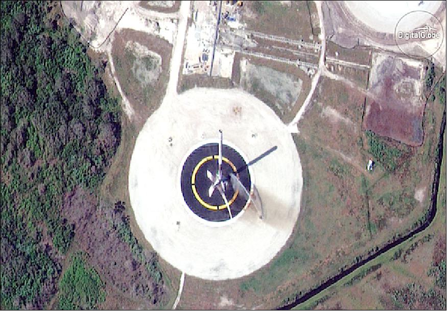
Figure 6: WorldView-4, captured this image at 10:49 a.m. EST (15:49 GMT) on 15 Dec. 2017, just minutes after the Falcon 9 first-stage booster returned to Earth with a flawless landing. A launch crew can be seen hosing down the rocket (image credit: Matthew Flannery, DigitalGlobe) 26)
Acquisition of DigitalGlobe by MDA 27) 28)
• October 5, 2017: MDA (MacDonald, Dettwiler and Associates Ltd.) of Richmond, BC, Canada, a global communications and information company providing technology solutions to commercial and government organizations worldwide, today announced it has completed its acquisition of DigitalGlobe, Inc. ("DigitalGlobe"), the global leader in high-resolution Earth imagery and information about our changing planet. The merger creates the leading integrated commercial provider of satellites, imagery and geospatial solutions to commercial and government customers worldwide. The newly combined company will offer a broader set of space-based solutions, increased scale and a more diversified revenue base.
New Corporate Name: MDA also announced today that it will become Maxar Technologies Ltd., and its U.S.-headquartered operating company, SSL MDA Holdings, Inc., will become Maxar Technologies Holdings Inc. The new Maxar Technologies launches a distinctive group of leading space brands, technologies and capabilities.
Canada-based MDA and U.S.-based DigitalGlobe overcame an extended review by the Committee on Foreign Investment in the United States (CFIUS) after refiling merger paperwork in July. The inter-agency committee, which reviews potential national security risks from foreign buyers of American businesses, ultimately found no issue with the merger.
MDA Corp.'s president and chief executive Howard Lance stated: "Maxar Technologies encompasses four of the leading commercial space technology brands—SSL, MDA, DigitalGlobe and Radiant—and represents the expanded benefits and value we will offer to our customers, shareholders, partners and employees."
With the addition of DigitalGlobe and Radiant Solutions, the Maxar Technologies portfolio of best-in-class brands offers a full suite of end-to-end solutions capabilities with deep domain expertise and space heritage.
- SSL: the leading commercial provider of communications and Earth observation satellites and scientific mission spacecraft for commercial and government markets
- MDA: an internationally recognized leader in space robotics, satellite antennas and subsystems, surveillance and intelligence systems, defence and maritime systems and geospatial radar imagery
- DigitalGlobe: the global leader in high-resolution optical satellite imagery and information about our changing planet; and
- Radiant: a highly specialized provider of geospatial data, analytics, software and services to facilitate insights and intelligence where and when it matters most.
• September 2017: WorldView-4 Launch and Calibration Timeline: 29)
- Launch: 11 November 2016
- First image: 21 November 2016
- Relative radiometric calibration: 03 December 2016
- Geometric camera calibration: 12 December 2016
- Geometric accuracy: 1 February 2017
- Absolute radiometric calibration: 8 February 2017.
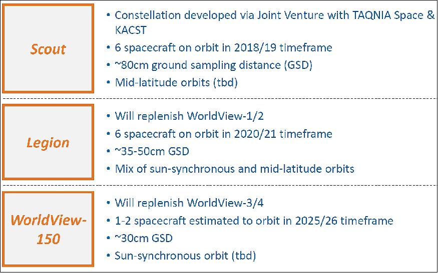
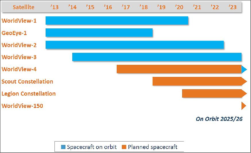
• September 2017: DigitalGlobe's Future Constellations: 30)
• August 15, 2017: Digital Globe today announced that it signed a DAP (Direct Access Program) contract with the Australian Department of Defence. This multi-year agreement will allow the Australian government to access DigitalGlobe's industry-leading commercial satellite imaging constellation to support defence and intelligence missions. The contract is expected to deliver $83.0 million USD in incremental revenue to DigitalGlobe over four years, beginning in January 2018. 31)
- As a DAP partner, the Australian Department of Defence will be able to directly task and download imagery in real-time to its ground station from all five DigitalGlobe satellites—including WorldView-4, launched in November 2016, and WorldView-3, launched in August 2014, which are the world's two highest-resolution commercial satellites. The addition of Australia—a key ally of the U.S. and member of the Five Eyes intelligence alliance—expands the global footprint of DigitalGlobe's DAP program and reflects the Australian government's commitment to increase the use of commercial satellite imagery for its critical national defence and intelligence missions.
• April 18, 2017: EUSI (European Space Imaging) announced that the company has launched its new ground station with access to the entire fleet of its WorldView Global Alliance DigitalGlobe partner. The Munich-based company is now able to directly handle five high-resolution satellites (GeoEye-1, WorldView-1, WorldView-2, WorldView-3 and WorldView-4). This speeds up the whole process of planning, collection, data downlink and delivery and allows European Space Imaging to quickly deliver satellite imagery products to WorldView Global Alliance customers in Europe, North Africa, CIS (Commonwealth of Independent States) countries and the Middle East. 32)
- "The capabilities of our new ground station and the direct access to the entire DigitalGlobe satellite fleet start a new era in the availability of highest resolution imagery in Europe. It's a major milestone especially in the 30 cm resolution class", says Adrian Zevenbergen, Managing Director of European Space Imaging. "In 2017, we plan to collect more than two times the entire European land mass with the 30 cm satellite constellation alone."
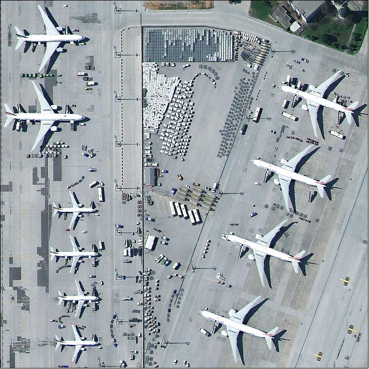

• February 6, 2017: The WorldView-4 commercial satellite, operated by DigitalGlobe, Inc., has successfully completed on orbit testing and calibration and started to serve the company's first direct access customer on February 1, 2017. 33) 34)
- WorldView-4, launched on November 11, 2016, becomes the fifth active satellite in DigitalGlobe's constellation of high-resolution Earth observation satellites. The satellite's performance meets the industry-leading quality standards of the WorldView fleet and joins WorldView-3 as the world's only commercial satellite capable of achieving 30 cm native resolution. Imagery with this level of detail enables users to reliably read street markings, distinguish between cars, trucks, and vans, and confidently understand activities of significance, as demonstrated by a recent SkyTruth analysis that used WorldView-3 imagery to document the likely transhipment of fish by Southeast Asian vessels in the Indian Ocean.
- The satellite more than doubles DigitalGlobe's capacity to collect 30 cm imagery, enhancing the company's ability to meet the most demanding commercial use cases, such as complementing aerial imagery collection strategies and enabling the creation of high-quality, imagery-derived products, such as high-resolution 3D models and near-seamless, country-scale base maps.
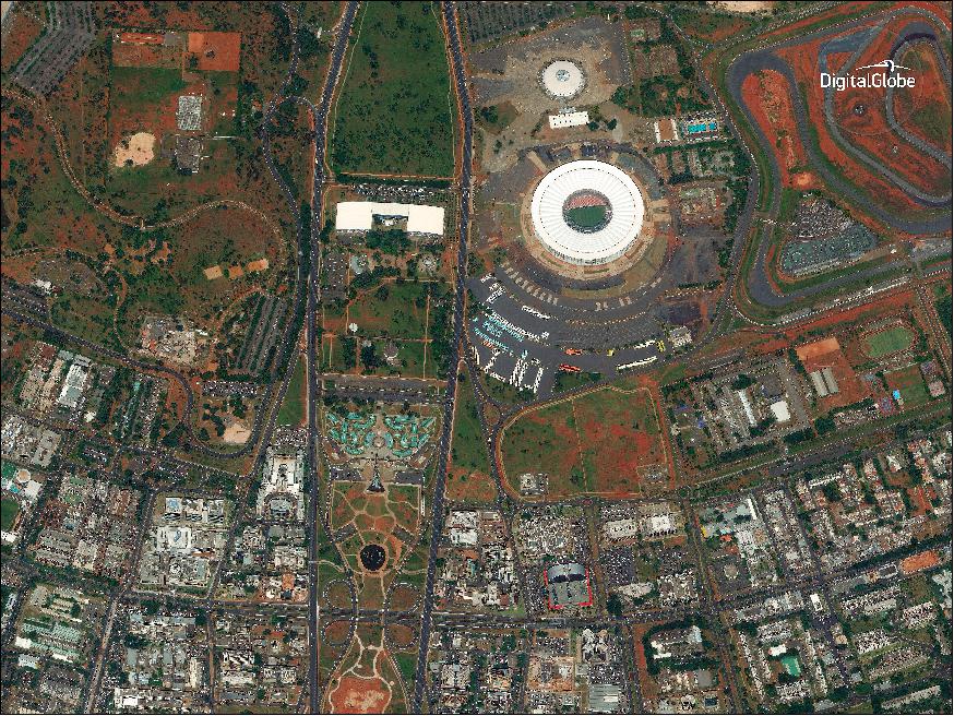

Legend to Figure 7: Subi Reef (also Zhubi Reef) is a reef in the Spratly Islands of the South China Sea located 26 km southwest of Philippine-occupied Thitu Island. It is occupied by China, and claimed by Taiwan, Vietnam, and the Philippines. It currently falls under the jurisdiction of Nansha islands, Sansha city, Hainan province, China. The atoll measures 5.7 km along its longer southwest-northeast axis, and is up to 3.5 km wide. Its total area including the lagoon and rim of the reef measures 16 km2, and the lagoon is up to 22 meters deep. 35)
• December 5, 2016: DigitalGlobe has released the first image from the company's WorldView-4 satellite, launched on Nov. 11, 2016. 36)

• WorldView-4 is the new companion to WorldView-3, effectively doubling the amount of best-on-the-market imagery with unmatched 30 cm resolution. WorldView-3 is booked by U.S. government contracts. WorldView-4 will enable DigitalGlobe sales to foreign allies and commercial uses like agriculture, mining, land developers and oil and gas firms.
Sensor Complement
SpaceViewTM 110 Imaging System
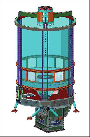
WorldView-4 will enable expanded capability in the collection of sub-meter imagery to help solve real-world problems. The Harris SpaceView™ line of optical imaging systems offers a broad spectral range of high-resolution optical payloads. The SpaceView™ 110 solution for WorldView-4 will provide the highest resolution satellite imagery commercially available. 37)
The SpaceViewTM 110 payload serves as the imaging payload for DigitalGlobe's WorldView-3 and WorldView-4 satellites. Delivering up to 25 cm panchromatic resolution, SpaceViewTM 110 boasts the most advanced capabilities available from an imaging payload on the market today.
Scanning at 24,000 lines/second, the SpaceView 110 imaging payload is capable of providing an image spanning from London to Paris in just 45 seconds. This feature enables users to understand what is happening over a long distance as soon as possible.
Note: In May 2015, Harris Corp. of Melbourne, FL. acquired ITT Exelis Inc. of Fort Wayne, IN. 38)
ITT Corporation of Rochester, N.Y. received a subcontract from Lockheed Martin Space Systems to continue building the imaging system for GeoEye's next-generation Earth-imaging satellite, GeoEye-2, ITT announced on August 31, 2010. 39)
On March 1, 2011, ITT announced that it has satisfied a key milestone with the successful completion of the CDR (Critical Design Review) for the imaging system for GeoEye-2. 40)
In 2011, ITT Corporation's board of directors approved a plan to separate the company's businesses into three distinct, publicly traded companies. As of Oct. 31, 2011, ITT Exelis is the company involved in C4ISR (Command, Control, Communications, Computers, Intelligence, Surveillance and Reconnaissance) related products and systems and information and technical services. This pertains also to space systems.
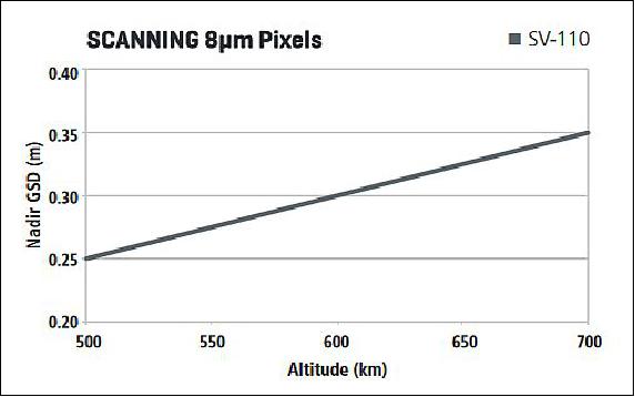
In April 2012, ITT Exelis Geospatial Systems has delivered GeoEye's next-generation commercial imaging system for the GeoEye-2 satellite to Lockheed Martin Space Systems Company in Sunnyvale, CA. The instrument provides a GSD (Ground Sample Distance) of 34 cm for panchromatic imagery and 1.36 m for multispectral imagery from an orbit of 681 km. 41)
WorldView-4 will provide map-accurate images with a new, high-resolution camera provided by Harris Corporation. In addition to delivering critical geospatial situational awareness and global security information to intelligence analysts, warfighters and decision-makers, commercial users will also benefit from access to imagery from WorldView-4.
WorldView-4 is a multispectral, high-resolution commercial satellite of DigitalGlobe.The SpaceView 110 instrument has a telescope of 1.1 m in diameter; it will provide imagery of 31 cm in panchromatic resolution and 1.24 m in multispectral resolution from an orbit of 617 km. 42) 43)
http://content.satimagingcorp.com.s3.amazonaws.com/static/satellite-sensor-specification/WorldView-4-Satellite-Specifications
Spectral bands | Panchromatic | 450 - 800 nm |
Multispectral (4 bands) | 450 - 510 nm (blue) | |
GSD (Ground Sample Distance) | Panchromatic nadir | 0.31 m |
Multispectral nadir | 1.24 m | |
Data quantization | 11 bit/pixel | |
Swath width | 13.1 km at nadir | |
Instrument aperture | 110 cm diameter | |
Instrument mass | 470 - 550 kg | |
Imaging power | 925 - 1100 W | |
Resolution @ 500 km (GSD) | 0.25 - 0.30 m | |
Sensor capabilities | • Staring | |
SpaceView 110 features:
- Industry-leading geolocation accuracy (predicted <4 m CE90 without ground control)
- High capacity in various collection modes
- Bi-directional scanning
- Rapid retargeting agility using Control Moment Gyros (>2x faster than any competitor) resulting in superior area and point target collection capability. Time to Slew 200 km: 10.6 seconds.
- Direct access tasking from and image transmission to customer sites
- Daily revisit capability.
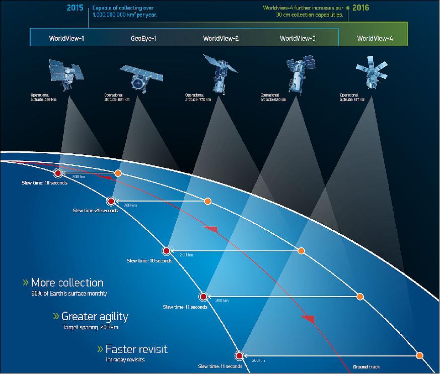
Feature | WorldView-1 | GeoEye-1 | WorldView-2 | WorldView-3 | WorldView-4 |
Operational altitude | 496 km | 681 km | 770 km | 617 km | 617 km |
Spectral characteristics | Pan | Pan+4MS | Pan+8MS | Pan + 8 MS + 8 SWIR | Pan + 4 MS |
Panchromatic resolution (nadir) | 0.50 m | 0.41 m | 0.46 m | 0.31 m | 0.31 m |
Multispectral resolution (nadir) | N/A | 1.64 m | 1.85 m | 1.24 m | 1.24 m |
Accuracy specification (nadir) | 6.5 m CE90 | 3 m CE90 | 6.5 m CE90 | 3.5 m CE90 | 4 m CE90 |
Swath width | 17.7 km | 15.3 km | 16.4 km | 13.2 km | 13.1 km |
Average revisit at 40ºN latitude | 1.7 days | <3 days | 1.1 days | 1.0 days | 1.0 days |
Monoscopic area coverage (30º off-nadir) | 111 km x 112 km | 45 km x 112 km | 138 km x 112 km | 69 km x 112 km | 66.5 km x 112 km |
Single-pass stereoscopic coverage (30 off-nadir) | 51 km x 112 km | 15 km x 112 km | 63 km x 112 km | 28 km x 112 km | 26.6 km x 112 km |
Weight class of spacecraft | 2500 kg | 1955 kg | 2800 kg | 2800 kg | 2600 kg |
Attitude control actuators | CMGs | Reaction wheels | CMGs | CMGs | CMGs |
Onboard storage capacity | 2199 Gbit | 1000 Gbit | 2199 Gbit | 2199 Gbit | 3200 Gbit |
Wideband data downlink rate | 800 Mbit/s total | 740 Mbit/s total | 800 Mbit/s total | 800 or 1200 Mbit/s total | 800 Mbit/s total |
Rapid delivery options | Direct Downlink, Virtual Ground Terminal | ||||
References
2) "GeoEye-2 the World Highest Resolution Satellite in Development," URL: http://www.eomag.eu/articles/765/geoeye-2-the-world-
highest-resolution-satellite-in-development
3) "Lockheed Martin Wins Contract To Build GeoEye-2," Space Daily, March 12, 2010, URL: http://www.spacedaily.com/reports/Lockheed_Martin
_Wins_Contract_To_Build_GeoEye_2_999.html
4) "GeoEye Wins $3.8 Billion National Geospatial-Intelligence Agency EnhancedView Award," GeoEye, Aug. 9, 2010, URL: http://geoeye.mediaroom.com/index.php?s=43&item=364
5) "GeoEye Wins National Geospatial-Intelligence Agency Enhanced View Award," Space Daily, Aug. 10, 2010, URL: http://www.spacedaily.com/reports/GeoEye_Wins_National_
Geospatial_Intelligence_Agency_Enhanced_View_Award_999.html
6) "Lockheed Martin Team Completes GeoEye-2 Preliminary Design Review Ahead of Schedule," Lockheed Martin, Dec. 6, 2010, URL: http://www.lockheedmartin.com/news/press
_releases/2010/1206-ss-geo-eye2-pdr.html
7) David Mulawa, "GeoEye Geolocation Assessment and Reporting Update for 2011," Proceedings of the 11th Annual JACIE (Joint Agency Commercial Imagery Evaluation ) Workshop, Fairfax, Va, USA, April 17-19, 2012, URL: http://calval.cr.usgs.gov/wordpress/wp-content/uploads
/mulawa-GeoEye-geolocation-JACIE-2012.pdf
8)"DigitalGlobe's WorldView-3 Satellite Continues on Track for Mid-2014 Launch - Company Will Complete GeoEye-2 Satellite to Preserve as Ground Spare," DigitalGlobe Press Release, Feb. 4, 2013, URL: [web source no longer available]
9) "DigitalGlobe—Accelerating The Launch + A Name Change (Satellite—Launch Preparations)," Satnews Daily, August 1, 2014, URL: http://www.satnews.com/story.php?number=2018960113#
10) "United Launch Alliance Atlas V Launches WorldView-3 Satellite for DigitalGlobe," ULA, Aug. 13, 2014, URL: http://www.ulalaunch.com/ula-
atlas-v-launches-worldview3-satellite.aspx
11) "MDA to provide ground stations with direct access to DigitalGlobe's WorldView-4 satellite," MDA Press Release, Dec. 10, 2015, URL: http://spaceref.com/news/viewpr.html?pid=47508
12) "WorldView-4," Lockheed Martin, 2016, URL: http://lockheedmartin.com/us/ssc/commspace.html
13) https://twitter.com/DigitalGlobe?ref_src=twsrc%5Etfw
14) Debra Werner, "WorldView-4's long road to launch about to pay off for DigitalGlobe," Space News Magazine, August 15, 2016, URL: https://web.archive.org/web/20200130222122/http://www.spacenewsmag.com:80/feature/worldview-4s-long-road-to-launch-%E2%80%A8about-to-pay-off-for-digitalglobe/
15) "Countdown to Launch: WorldView-4 Earth Imaging Satellite Arrives at Vandenberg Air Force Base for Sept. 15 Launch," Lockheed Martin, July 28, 2016, URL: http://www.lockheedmartin.com/us/news
/press-releases/2016/july/ssc-072816-worldview-shipping.html
16) "ULA launches latest DigitalGlobe commercial earth observation satellite WorldView-4," Space Daily, Nov. 14, 2016, URL: http://www.spacedaily.com/reports/ULA_launches_latest_DigitalGlobe
_commercial_earth_observation_satellite_WorldView_4_999.html
17) "Lockheed Martin Successfully Launches WorldView-4 Satellite for DigitalGlobe," Lockheed Martin, Nov. 11, 2016, URL: http://www.lockheedmartin.com/us/news/press-
releases/2016/november/worldview4-space-111116.html
18) "A Wending Its Way November 6th Launch Date Set For WorldView 4," Satnews Daily, Oct. 26, 2016, URL: http://www.satnews.com/story.php?number=1441135279
19) "WorldView-4's Atlas V launch vehicle to carry seven CubeSat missions for NRO," DigitalGlobe, July 25, 2016, URL: http://blog.digitalglobe.com/2016/07/25/worldview-4s-atlas-v-
launch-vehicle-to-carry-seven-cubesat-missions-for-nro/
20) "Tyvak Facilitates First NRO CubeSat Mission Aboard Non-Governmental Launch," Tyvak, Nov. 11, 2016, URL: https://web.archive.org/web/20171103190752/http://www.tyvak.com:80/tyvak-facilitates-first-nro-cubesat-mission-aboard-non-governmental-launch/
21) "Maxar Technologies to Receive Full Insurance Coverage for the Firm's WorldView-4 On-Orbit Failure," Satnews Daily, 6 May 2019, URL: http://www.satnews.com/story.php?number=1800170038&menu=1
22) "Maxar Technologies Reports Failure of its WorldView-4 Imaging Satellite," Maxar Technologies, 7 January, 2019, URL: http://investor.maxar.com/investor-news/press-release
-details/2019/Maxar-Technologies-Reports-
Failure-of-its-WorldView-4-Imaging-Satellite/default.aspx
23) Steve Cole, "NASA Evaluates Commercial Small-Sat Earth Data for Science," NASA Release 18-086, 04 October 2018, URL: https://www.nasa.gov/press-release/nasa-evaluates-
commercial-small-sat-earth-data-for-science
24) "Maxar Technologies' DigitalGlobe Integrates Highest Resolution Satellite Imagery from WorldView-4 into SecureWatch," SpaceRef, 22 April 2018, URL: http://spaceref.com/news/viewpr.html?pid=52497
25) "In first, SpaceX launches recycled rocket and spaceship," Space Daily, 15 Dec. 2017, URL: http://www.spacedaily.com/reports/In_first_SpaceX
_launches_recycled_rocket_and_spaceship_999.html
26) "DigitalGlobe Documents SpaceX's Successful 'Firsts' Times Two Includes Hosing Down a Falcon," Satnews Daily, 18 Dec. 2017, URL: http://www.satnews.com/story.php?number=1499463170#
27) "MDA Completes Acquisition of DigitalGlobe, Creates Industry Leader in Satellite Systems, Earth Imagery, Geospatial Solutions and Analytics," MDA Press Release, Oct. 5, 2017. URL: https://mdacorporation.com/news/pr/pr2017100509.html
28) Henry Caleb, "MDA closes DigitalGlobe merger, rebrands as Maxar Technologies," Space News, Oct. 5, 2017, URL: http://spacenews.com/mda-closes-digitalglobe-
merger-rebrands-as-maxar-technologies/
29) Chris Comp, David Mulawa, Brendan Clarke, Todd Updike, "WorldView-4 calibration - DigitalGlobe Constellation Update," JACIE (Joint Agency Commercial Imagery Evaluation) Workshop, Reston, VA, USA, Sept. 19-21, 2017, URL: https://calval.cr.usgs.gov/wordpress/
wp-content/uploads/Chris-Comp.pdf
30) "DigitalGlobe Satellite and Product Overview," JACIE (Joint Agency Commercial Imagery Evaluation) Workshop, Reston, VA, USA, Sept. 19-21, 2017, URL: https://calval.cr.usgs.gov/wordpress/wp-content/uploads/Digital-Globe-1-2.pdf
31) "DigitalGlobe Announces Four-Year Direct Access Contract with the Australian Department of Defence for Real-time Access to the World's Highest-Resolution Commercial Satellite Imagery," Business Wire, 15 Aug. 2017, URL: https://www.businesswire.com/news/home/20170815
005046/en/DigitalGlobe-Announces-Four-Year-
Direct-Access-Contract-Australian
32) "European Space Imaging starts commercial distribution of WorldView-4 satellite imagery in Europe," EARSC (European Association of Remote Sensing Companies), April 18, 2017, URL: http://earsc.org/news/european-space-imaging-starts-commercial-distribution-of-worldview-4-satellite-imagery-in-europe
URL: http://mailchi.mp/euspaceimaging/worldview-
4-data-now-available?e=2c05008044
33) "WorldView-4 enters service," DigitalGlobe, Feb. 1, 2017, URL: http://worldview4.digitalglobe.com/#/main
34) "WorldView-4 Is Up and Capturing," Satnews Daily, Feb. 6, 2017, URL: http://www.satnews.com/story.php?number=1906185948
35) "Subi Reef," Wikipedia, URL: https://en.wikipedia.org/wiki/Subi_Reef
36) "WorldView-4 first image, " DigitalGlobe, URL: http://worldview4.digitalglobe.com/#/main
37) "SpaceView 110 Satellite Imaging Solution," Harris, URL: https://www.harris.com/sites/default/files/downloads/solutions/
55805_sv110_datasheet_final_digital.pdf
38) "Harris Corporation Completes Acquisition of Exelis," Press Release, May 29, 2015, URL: http://www.exelisinc.com/news/pressreleases/Pages
/Harris-Corporation-Completes-Acquisition-of-Exelis.aspx
39) "ITT awarded contract to build the Imaging System for the GeoEye-2 Earth-Imaging Satellite," August 31, 2010, URL: http://www.geospatial.itt.com/news/news_100831.shtml
40) "ITT's Next-Generation Imaging Payload Passes Major Milestone," March 1, 2011, URL: http://www.geospatial.itt.com/news/news_110301.shtml
41) "ITT Exelis delivers imaging system for next-generation, high-resolution GeoEye-2 satellite," Space Daily, April 11, 2012, URL: http://www.spacedaily.com/reports/ITT_Exelis_delivers
_imaging_system_for_next_generation
_high_resolution_GeoEye_2_satellite_999.html
42) "WorldView-4 Data Sheet," Digital Globe, Nov. 15, 2015, URL: https://dg-cms-uploads-production.s3.amazonaws.com/uploads/document/file/
196/DG_WorldView4_DS_11-15_Web.pdf
43) "WorldView-4 Data Sheet," Digital Globe, URL: http://content.satimagingcorp.com.s3.amazonaws.com/static/satellite-
sensor-specification/WorldView-4-Satellite-Specifications
44) "The DigitalGlobe Constellation," DigitalGlobe brochure, 2016, URL: https://dg-cms-uploads-production.s3.amazonaws.com/
uploads/document/file/
223/Constellation_Brochure_forWeb.pdf
The information compiled and edited in this article was provided by Herbert J. Kramer from his documentation of: "Observation of the Earth and Its Environment: Survey of Missions and Sensors" (Springer Verlag) as well as many other sources after the publication of the 4th edition in 2002. - Comments and corrections to this article are always welcome for further updates (eoportal@symbios.space).
Spacecraft Launch Mission Status Sensor Complement References Back to Top