DubaiSat-1
EO
Mission complete
MBRSC
UAE SA
DubaiSat-1 was a remote sensing minisatellite project of the Mohammed Bin Rashid Space Centre (MBRSC) which launched in July 2009 and completed its mission in July 2013. The satellite provided high-resolution images in the visible spectrum for numerous applications, including infrastructure planning and disaster monitoring.
Quick facts
Overview
| Mission type | EO |
| Agency | MBRSC, UAE SA |
| Mission status | Mission complete |
| Launch date | 29 Jul 2009 |
| End of life date | 29 Jul 2013 |
| Measurement domain | Land |
| Measurement category | Multi-purpose imagery (land) |
| Measurement detailed | Land surface imagery |
| Instruments | DMAC |
| Instrument type | High resolution optical imagers |
| CEOS EO Handbook | See DubaiSat-1 summary |
Summary
Mission Capabilities
DubaiSat-1 carried the DubaiSat-1 Medium Aperture Camera (DMAC) to take high-resolution images paired with a Space Radiation Monitor (SRM) to measure the ionizing dose of charged particles. The satellite had an Attitude Control Subsystem (ACS) composed of Coarse Sun Sensors (CSS) used for solar panel orientation, Fine Sun Sensors (FSS) for higher sub-arcminute accuracy and smaller angular resolution, Magnetometers (MAG) used for navigational purposes, Fiber-optical Gyros (Gyro) used for measuring the satellite’s orientation and rotational movement, and Star Sensors (STS) also used to measure the orientation of the satellite relative to stars.
The CPU (central processing unit) used was the ERC-32, a radiation-tolerant processor, which includes the Flight Operations Segment (FOS) software which controls data collection and commands, saves information and performs scheduled tasks.
Performance Specifications
DMAC had a panchromatic (PAN) spatial resolution of 2.5 m and a multispectral spatial resolution of 5 m. The imager used a pushbroom imaging technique with a swath width of 20 km within a field of view of 720 km. Global coverage would take four months with a revisit time of four days for a specific area.
The satellite maintained a Sun-synchronous orbit with an inclination of 98.13° at an altitude of 686 km and had an orbital period of 97.7 minutes.
Space and Hardware Components
The Satrec Initiative (SI-200) System was used for the satellite bus as it made assembly and disassembly easier. It was roughly 1.2 m in diameter and 1.35 m in height, with most components positioned on the bottom deck. Gyroscopes and four Reaction Wheels (RW), which allowed satellite motion control, were placed in the middle. The launch mass of DubaiSat-1 was approximately 200 kg with a design life of five years.
The Electrical Power Subsystems (EPS) consisted of three solar arrays for when the satellite is in the sunlit portion of its orbit providing power of over 330 W, three NiCd battery packs with 14.4 Ah for the eclipse period of its orbit, and power distribution electronics to distribute power from the solar arrays.
DubaiSat-1
Spacecraft Launch Mission Status Sensor Complement Ground Segment References
DubaiSat-1 is a remote sensing minisatellite project of MBRSC (Mohammed Bin Rashid Space Center), former EIAST (Emirates Institution for Advanced Science and Technology), a UAE (United Arab Emirates) organization which is part of the Dubai government. It represents the need of UAE and Dubai in acquiring the technology of developing satellites and the continuous need for spatial information and Earth observation data of UAE as well as on a global scale. The vision of EIAST is to introduce a space program on a national level by supporting university projects to stimulate interest in a problem‐solving multi‐disciplinary technical environment, leading eventually to an indigenous and sustained space program of UAE. With regard to DubaiSat-1, facilities are needed (a ground segment and some infrastructure) as well as international collaborations to make spaceflight possible. 1)
In May 2006, EIAST awarded a contract to SI (Satrec Initiative Co. Ltd.) of Daejeon, Korea with the objective to design and develop a small satellite along with an imaging payload - and to provide a TTP (Technology Transfer Program) involving on-the-job training of a team of ~10 young engineers and scientists from UAE. 2) 3)
The overall requirements call for a sun-synchronous LEO (Low Earth Orbit) imaging mission providing high-resolution panchromatic and multispectral imagery in the visible range to be used for a number of applications. The government of Dubai intends to use the data in such fields as urban and infrastructure planning and disaster monitoring.
Spacecraft
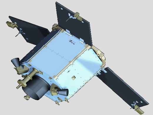
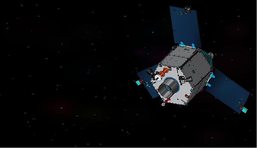
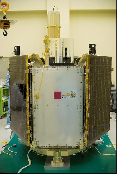
The structure of DubaiSat-1 is a cylindrical body of hexagonal shape featuring three deployable solar panels. The bus structure is referred to as deck-and-longeron type allowing easy assembly and disassembly. The bus dimensions are about 1.2 m in diameter and 1.35 m in height. The bus is referred to as the SI-200 (Satrec Initiative) system.
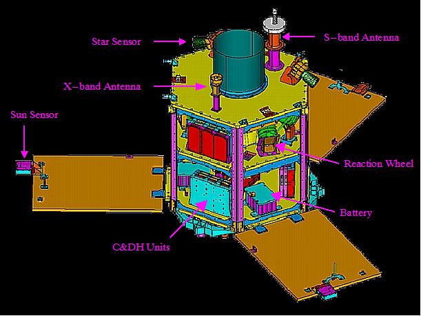
Most of the component units are positioned on the bottom deck, while reaction wheels and gyros are positioned on the middle deck. The interface with the launch vehicle is made through an adapter (specific to each launch vehicle) bolted to the bottom of the structure. The mechanical interface with the payload EOS (Electro-Optical Subsystem) is provided through three points at the middle deck. The launch mass of DubaiSat-1 is < 200 kg. The spacecraft has a design life of 5 years.
The spacecraft is 3-axis stabilized. The ACS (Attitude Control Subsystem) consists of the following sensors: Fine and Coarse Sun Sensors (FSS & CSS), Magnetometers (MAG), Fiber-optical Gyros (Gyro), and Star Sensors (STS). Actuation is provided by 4 RW (Reaction Wheels) and MTQs (Magnetorquers). The four RWs are configured in a tetrahedral scheme to provide optimum performance and redundancy. The MTQs are used to desaturate the reaction wheel assembly.
DubaiSat-1 is an agile spacecraft providing a body pointing capability of up to ±45º in along-track as well as in cross-track. The pointing knowledge accuracy is < 10 arcsec and the control stability is better than 0.016 º/s. The ACS commands are generated in the OBC using the Flight Control Software (FCS). - All components of the ACS are space-qualified having been used on previous missions successfully. 4) 5) 6) 7) 8) 9)
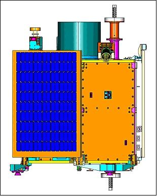
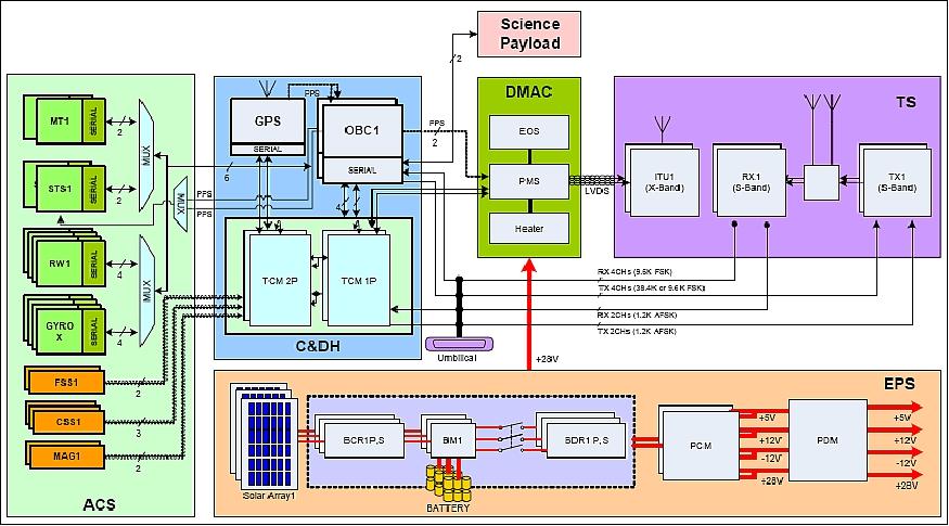
The EPS (Electric Power Subsystem) consists of three solar arrays, three battery packs, and power distribution electronics. The solar arrays are attached to three deployable solar panels. NiCd batteries are used as energy storage devices for eclipse operation and to compensate for excessive power consumption in high power demand phases. During the sunlit portion of the orbit, the power from the solar arrays is used to provide > 330 W (EOL). This power is distributed to all subsystems in the satellite and is also used to charge the batteries. During the eclipse period, the power from the batteries is used for all subsystems with maintaining the low performance of subsystems. The depth of discharge of any battery shall not exceed 20% during operation, to be able to sustain its lifetime of 5 years. The battery assembly has a nominal capacity of 14.4 Ah at EOL (End of Life). - The solar arrays and batteries are space-qualified items which have been used on previous missions successfully.
The C&DH (Command and Data Handling) subsystem is used to control the flow of communication between all modules of the spacecraft including the payload. It uses two OBCs (On-Board Computers) where one is redundant, four TMC (Telemetry and Command Modules) where two are redundant, a GPS receiver and the onboard software. The TMCs are used to collect data from subsystems and control the flow in and out of the OBC. The GPS receiver is used for time synchronization between modules and for fine satellite positioning.
The CPU used in the OBC is the ERC-32 which includes the FOS (Flight Operations Segment) software which controls the telemetry and commands, saves the information and performs scheduled tasks with the various subsystems. The OBC includes also the FCS (Flight Control Software) which is specified for controlling the satellite attitude and performing manoeuvres if necessary.
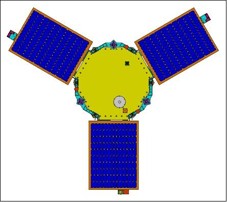
The spacecraft coordinate system is defined as follows: +X is defined along the scanning direction of DMAC, which is normal to the detector line, +Z is aligned with the DMAC optical axis, and +Y is the deployed direction of one of the solar panels (SP-C) and perpendicular to +X and +Z axes. The origin of the coordinate is defined at the centre of the adaptor.
Three S/C adaptors are connected to the shear brackets and mechanically couple the satellite and separation adaptor of the launch vehicle. Each one of the S/C adaptors has two S/C-based separation sensors and one LV-based separation sensor to monitor the separation conditions between the satellite and the launch vehicle.
The spacecraft bus system utilizes passive thermal control, while the DMAC payload and battery system implement active thermal control methods. All bus subsystems are thermally interconnected. The DMAC assembly is thermally isolated from the bus. The heater for EOS is controlled by TPM and has full redundancy. The PHCE (Pyro & Heater Control Electronics) controls other heaters. In particular, the survival heater for the battery pack is operated during the sunlight period only.
Mass of minisatellite, design life | ~ 200 kg, 5 years |
Bus size | 1.2 m in diameter, 1.35 m high (hexagonal) |
Spacecraft stabilization | 3-axis stabilized |
ACS (Attitude Control Subsystem) | - Sensors: Fine and Coarse Sun Sensors (FSS & CSS), Magnetometers (MAG), Fiber-optical Gyros (Gyro), Star Sensors (STS) |
EPS (Electric Power Subsystem) | - Power of > 330 W is provided at EOL |
C&DH subsystem | Use of ERC-32 CPU |
RF communications | S-band transmission for TT&C data; downlink: 9.6 or 38.4 kbit/s; uplink = 9.6 kbit/s |
Launch
DubaiSat-1 (prime payload) was launched on July 29, 2009. The launch site was Baikonur, Kazakhstan. The launch provider was ISC (International Space Company) Kosmotras of Moscow, Russia (Dnepr vehicle). The shared payload manifest of the launch was:
• DubaiSat-1 an imaging microsatellite of the UEA (United Arab Emirates) Institution for Advanced Science and Technology (EIAST) is the main payload on this flight
• Deimos-1 (Spain), UK-DMC-2 (SSTL, United Kingdom)
• AprizeSat-3, AprizeSat-4, LEO AIS (Automatic Identification System) communication experiments of Aprize Satellite Inc., Fairfax, VA, USA. Each S/C has a mass of 12 kg.
• NanoSat-1B of INTA (Instituto Nacional de Técnica Aeroespacial), Spain (23.5 kg).
Orbit: Sun-synchronous near-circular orbit, altitude = 686 km, inclination = 98.13º, the orbital period is about 97.7 minutes, the LTAN (Local Time on Ascending Node) is at 10:30 hours.
RF communications (telecommunications subsystem:
TS): An S-band link is being used for TT&C transmissions between to spacecraft and the ground station; the downlink is 9.6 or 38.4 kbit/s, and the uplink is 9.6 kbit/s. The X-band downlink of 30 Mbit/s is being used for image data transmissions. Two ITUs (Image Transmission Units) are used for redundancy. Each produces a 5 W (+37 dBm) signal for high data rate transmission using QPSK (Quadra-Phase Shift Keying) modulation.
Two S-band transmitters (STX) are used for redundancy. The STX has an output power of 2 W, which secures +33 dBm for the data link. In addition, two S-band receivers (SRX) are also used for uplink redundancy. An MMIC is used as a low-noise amplifier (LNA) to amplify the weak received signals as it has low noise and high gain characteristics with high reliability. Two S-band antennas are placed on the top and bottom of the spacecraft to provide omnidirectional coverage. The SRX and STX share these antennas using a duplexer and a power divider.
Mission Status
• March 2017: The DubaiSat-1 mission has come to the end of its operational life (imaging operations), and current contacts are for various testing and telemetry download (Ref. 10).
• May 09.2016: According to information from MBRSC, the DubaiSat-1 mission is in its EOL (End of Life) phase and stopped imaging. Once in a while, the project is able to contact DS-1 to download data and monitor the status of the satellite. 10)
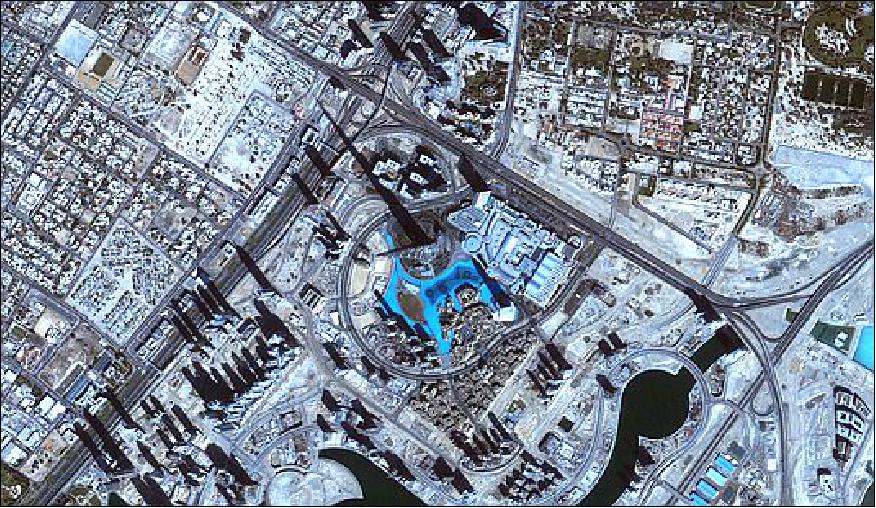
• August 11, 2015: MBRSC (Mohammed Bin Rashid Space Center) celebrated the sixth anniversary of DubaiSat-1, the first remote sensing satellite owned by the UAE (United Arab Emirates), making the first step the country has taken in its journey into the satellite manufacturing sector. DubaiSat–1 marked the occasion by taking high-quality images of Burj Khalifa and Emirates Towers areas. 11)
- The Satellite has been sending back spectacular, high-resolution imagery of the Earth since its launch in 2009.Dubai-Sat-1 was the first wholly-owned UAE satellite, and it generates optical images in panchromatic and multispectral bands at spatial resolutions of 2.5 m and 5 m, respectively. The satellite is a vital tool in helping the UAE and the Middle East develop infrastructure, monitor environmental changes and complete urban planning. DubaiSat-1 images are also integral to the promotion of geoscience and the support of a variety of science programs in both academia and the private sector. 12)
• May 2015: The DubaiSat-1 spacecraft and its payload are operating nominally in 2015 (beyond its design life). On July 29, 2015, it will complete 6 years on orbit. —
Note: On April 18, 2015, EIAST (Emirates Institution for Advanced Science and Technology) was officially renamed to MBRSC (Mohammed Bin Rashid Space Center). 13)
• The DubaiSat-1 spacecraft and its payload are operating nominally in 2014, in its 5th year on orbit (Ref. 16).
• The DubaiSat-1 spacecraft and its payload are operating nominally in 2013 (Ref. 16). In December 2012, DubaiSat-1 had captured more than 10,000 images of the globe. EIAST is distributing the processed imagery to government agencies and educational institutions of Dubai; in addition, the data are used commercially (Ref. 16).
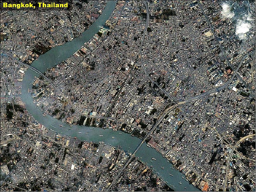
• On July 29, 2012, DubaiSat-1 was 3 years on-orbit.
• The DubaiSat-1 spacecraft and its payload are operating nominally in 2012 (Ref. 16).
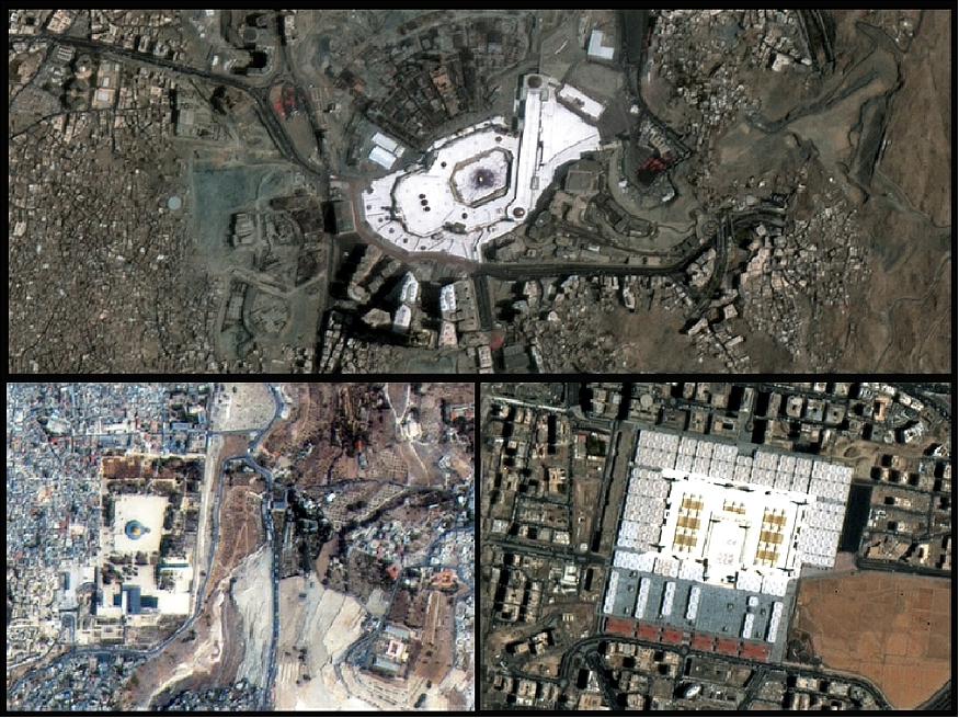
Legend to Figure 11: The three Holy Cities receive a large number of worshippers and pilgrims during Ramadan. Saudi Arabia alone expects around four million pilgrims during this Ramadan and infrastructure in Mecca and Medina is constantly being upgraded to facilitate convenient accommodation and movement of pilgrims. The images in Figure 11 are, clockwise from top:
- The Grand Mosque in Mecca, captured by DubaiSat-1 on July 22, 2011
- The Prophet's Mosque in Medina, captured by DubaiSat-1 on July 25, 2011
- Al-Aqsa Mosque in Al Quds.
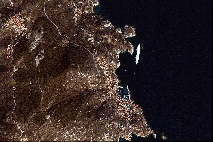
• In January 2011, the DubaiSat-1 spacecraft and its payload are operating nominally (after 1 ½ years on orbit). The spacecraft design life is 5 years. 16)
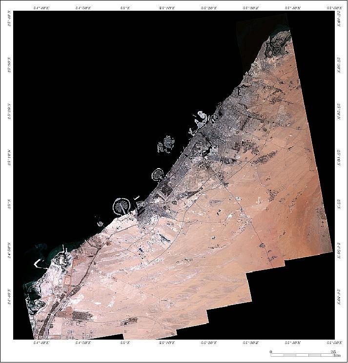
• EIAST celebrated the first anniversary of DubaiSat-1 in orbit on July 29, 2010. The spacecraft and its payload are operating nominally. 17)
• The commissioning phase of DubaiSat-1 ended in late January 2010; this was followed by nominal operations. 18) 19)
• The first month after launch was dedicated to checkout of all spacecraft functions and for the very initial calibration and validation functions of the imagery. 20)
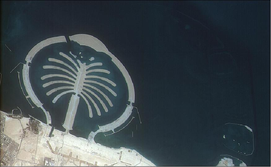
• On Aug. 9, 2009 DubaiSat-1 transmitted its first series of UAE images from orbit, including a snapshot of the Palm Jebel Ali. 21)

Sensor Complement
DMAC (DubaiSat-1 Medium Aperture Camera)
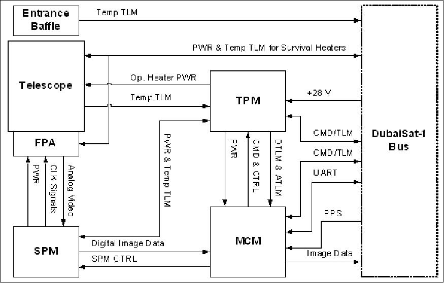
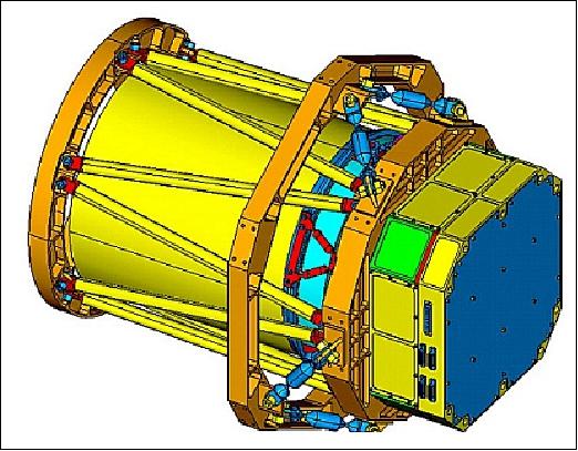
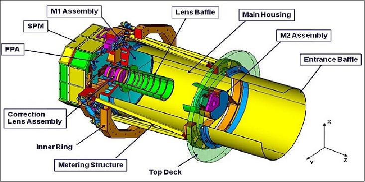
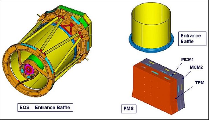
DMAC is an optical pushbroom type camera with one panchromatic and four multispectral (MS) imaging bands. DMAC consists of EOS (Electro-Optical Subsystem) and PMS (Payload Management Subsystem). EOS in turn is comprised of the telescope, the FPA (Focal Plane Assembly), and SPM (Signal Processing Module). The PMS (consists of the TPM (Thermal & Power Module) and the MCM (Mass storage and Control Module). 22) 23)
Spectral bands | Pan (panchromatic): 420-890 nm (the Pan and MS data are co-registered) |
Telescope aperture | 30 cm optical diameter |
IFOV (Instantaneous Field of View) | Pan: 3.68 µrad |
Spatial resolution | 2.5 m (Pan), 5 m (MS) |
Swath width | 20 km at nadir |
FOR (Field of Regard) | 720 km (this provides an event monitoring capability) |
Detector | CCD type |
MTF (Modulation Transfer Function) | Pan: ≥ 8.0% @ Nyquist frequency |
Data quantization | 8 bit |
Data storage capacity | 64 Gbit |
Instrument mass, power | 38.7 kg, 52.3 W (max), 14 W (standby) |
Instrument physical size | Optics: Ø 420 mm x 755 mm |
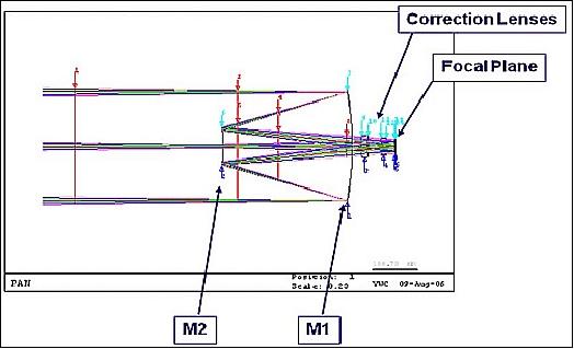
The telescope is made of various optical and mechanical components. It is an on-axis catadioptric telescope shared between all imaging bands of the DMAC system. The telescope collects the incoming radiation from the instantaneous ground scene and focuses the collected radiation onto the FPA. It consists of M1A (Primary Mirror Assembly), M2 A (Secondary Mirror Assembly), CLA (Correction Lens Assembly), the metering structure as well as other structural components.
The FPA consists of linear detectors which convert the focused radiation of the 5 bands into raw video signals. The SPM receives the video signals processing them and converting the output into digital signals which are forwarded to the MCM for onboard storage. The imagery may be downlinked directly or on a scheduled basis. MCM interfaces also with the TPM providing temperature control management of the DMAC instrument. In addition, MCM monitors and controls the power supplied to the electronics and sensors. All the modules have redundancy except the optical part and the FPA (Figure 16).

SRM (Space Radiation Monitor)
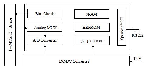
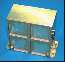
The objective of SRM is to measure the total ionizing dose from the population of charged particles at the orbital altitude (in situ measurement). The instrument utilizes 4 p-type MOSFET (Metal-Oxide-Semiconductor Field Effects Transistor) devices to measure the current-voltage (I-V) characteristics. Subsequent analysis of the I-V curve permits the determination of the amount of the cumulative ionizing dose, and the TID (Total Ionizing Dose) of the devices.
Ground Segment
Spacecraft operations are being conducted at MSC (Mission Control Center) located at EIAST headquarters in Dubai, UAE. The S-band receiving station is collocated with the MSC. In addition, there is the Image Receiving and Processing Station (IRPS) for all X-band data reception as well as data processing, distribution and archiving.
MCS plans and operates the entire space mission, including the configuration and scheduling of resources for both space and ground element. It also monitors and commands the satellite.
The antenna and RF subsystem consist of an 11.3 m antenna system, an S-band transmitter feed, an S-band receiver feed, an X-band receiver feed, and tracking system. The RF equipments including transmitting and receiving antenna are being used to communicate with the spacecraft. The antenna system was provided by ViaSat Inc. of Carlsbad, CA, USA. 24)
References
1) The information of the DubaiSat-1 project was provided by Salem Al Marri of EIAST, UAE and by Sungdong Park of SI (Satrec Initiative), Daejeon, Korea
2) "DubaiSat-1 international specialists and local talents participate at the Dubai AirShow 2007," Nov. 11, 2007, URL: http://www.ameinfo.com/137913.html
3) http://www.eiast.ae/default.aspx
4) Byungjin Kim, Salem Al Marri, Norhizam Hamzah, "SI-200 Mini-Satellite Platform for Earth Observation Missions," Proceedings of the 60th IAC (International Astronautical Congress), Daejeon, Korea, Oct. 12-16, 2009, IAC-09.B1.1.3
5) Adnan Al Rais, Ali Al Suwaidi, Hosni Ghedira, "DubaiSat-1: Mission Overview, Development Status and Future Applications," Proceedings of IGARSS 2009 (IEEE International Geoscience & Remote Sensing Symposium), Cape Town, South Africa, July 12-17, 2009, URL: http://www.eiast.ae/download/0500196.pdf
6) H. Ghediraa, A. AlRais, A. AlSuwaidi, A. Bushahab, A. Al Muhairi, "DubaiSat-1 mission and its potential to advance research on semiarid and arid environments," 33rd International Symposium on Remote Sensing of Environment (ISRSE), Stresa, Italy, May 4-8, 2009, URL: http://www.eiast.com/download/research.pdf
7) "DubaiSat-1 Space Segment," URL: http://www.eiast.ae/default.aspx?-options={a93e7034-0baa-4e2b-be21-721a4b6feb8e}&view=Article&layout=Article&itemId=113&id=81
8) Sungdong Park, Byungjin Kim, Hyonsock Chang, Ee-Eul Kim, Salem Al-Marri, "Revolution in Demand and Supply during Last 10 Years in Small Earth Observation Satellites," Proceedings of the 24th Annual AIAA/USU Conference on Small Satellites, Logan, UT, USA, Aug. 9-12, 2010, SSC10-IV-06
9) "DubaiSat-1 Technical Specifications," MBRSC, URL: http://mbrsc.ae/en/page/technical-specifications
10) Information provided by Fatma Ali AlSumatti (Officer, Business Development & External Relations) of MBRSC, Dubai.
11) Grace Haber, "MBRSC 6th Anniversary of DubaiSat-1," Aug. 15, 2015, Press Release, URL: http://commfirm.com/wp-content/uploads/2015/08/mbrsc-dubaisat-1anniversary.pdf
12) "The UAE's first satellite project that contributed to scientific knowledge transfer to advance the team's capabilities," MBRSC, URL: http://mbrsc.ae/en/page/dubai-sat-1
13) Information provided by Adnan Al Rais of MBRSC (Mohammed Bin Rashid Space Center), Dubai,UAE (United Arab Emirats).
14) "Satrec Initiative- Challenging Space Smart," URL: http://www.satreci-us.com/documents/presentations/Introduction%20to%20SI_July%202011.pdf
15) "Dubaisat takes stunning shot of Costa Concordia," EIAST, published on March 18, 2012, URL: http://www.emirates247.com/news/emirates/dubaisat-takes-stunning-shot-of-costa-concordia-2012-03-18-1.449047
16) Information provided by Salem Al Marri of EIAST, Dubai,UAE (United Arab Emirats).
17) "EIAST celebrates first anniversary of DubaiSat-1 launch," Aug.9, 2010, URL: http://www.arabianaerospace.aero/article.php?section=technology&article=eiast-celebrates-first-anniversary-of-dubaisat-1-launch
18) Information provided was provided by Salem Al Marri of EIAST, UAE.
19) "The UAE's Space activities," UNOOSA STSC (Scientific and Technical Subcommittee), 47th Session, Vienna, Austria, Feb. 8-19, 2010, URL: http://www.oosa.unvienna.org/pdf/pres/stsc2010/tech-04.pdf
20) Wonkyu Park, Adnan Al Rais, Minyo Hong, Hyundeok Hwang, Keumhee Oh, Jihyun Shin, Sunghee Kwak, "Initial Calibration and Validation Results of DubaiSat-1 Images," Proceedings of the 60th IAC (International Astronautical Congress), Daejeon, Korea, Oct. 12-16, 2009, IAC-09.B4.4.7
21) "EIAST showcases expertise in developing DubaiSat-1 Engineering Conference 2010," Dubai Chronicle, April 23, 2010, URL: http://www.dubaichronicle.com/tag/dubaisat-1
22) Ee-Eul Kim, Salem Al Marri, "Testing and Characterization of the DubaiSat-1 Imaging System," Proceedings of the 4th International Conference on Recent Advances in Space Technologies (RAST 2009), Istanbul, Turkey, June 11-13, 2009
23) Young-Wan Choi, Abdalla Harmoul, Myungseok Kang, Suhail Al Dhafri, Ee-Eul Kim, "DubaiSat-1 Camera: Pre-launch Performance Characterization," Proceedings of the 60th IAC (International Astronautical Congress), Daejeon, Korea, Oct. 12-16, 2009, IAC-09.B1.3.10
24) "DubaiSat-1 Ground Segment," EIAST, 2009, URL: http://www.eiast.ae/default.aspx?options={a93e7034-0baa-4e2b-be21-721a4b6feb8e}&view=Article&layout=Article&itemId=114&id=82
The information compiled and edited in this article was provided by Herbert J. Kramer from his documentation of: "Observation of the Earth and Its Environment: Survey of Missions and Sensors" (Springer Verlag) as well as many other sources after the publication of the 4th edition in 2002. - Comments and corrections to this article are always welcome for further updates (eoportal@symbios.space).
Spacecraft Launch Mission Status Sensor Complement Ground Segment References Back to Top