HJ-1(Huan Jing-1: Environmental Protection & Disaster Monitoring Constellation)
EO
Atmosphere
Ocean
Cloud type, amount and cloud top temperature
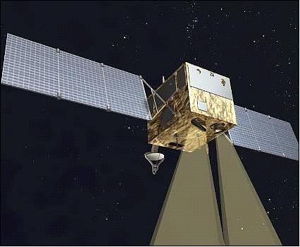
HJ (Huanjing, meaning “environment” in Chinese) is a minisatellite constellation mission, commissioned by the National Committee for Disaster Reduction and State Environmental Protection Administration (NDRCC/SEPA) of China. The primary objective was to establish a remote sensing infrastructure for disaster mitigation and relief, additionally, they conduct environmental tracking and waste monitoring. The first two satellites, HJ-1A and HJ-1B were launched in September 2008, and HJ-1C was launched in November 2012.
Quick facts
Overview
| Mission type | EO |
| Agency | CAST, CRESDA |
| Mission status | Mission complete |
| Launch date | 06 Sep 2008 |
| End of life date | 01 Mar 2023 |
| Measurement domain | Atmosphere, Ocean, Land, Snow & Ice |
| Measurement category | Cloud type, amount and cloud top temperature, Ocean colour/biology, Multi-purpose imagery (ocean), Radiation budget, Multi-purpose imagery (land), Vegetation, Albedo and reflectance, Landscape topography, Ocean topography/currents, Sea ice cover, edge and thickness, Snow cover, edge and depth |
| Measurement detailed | Ocean imagery and water leaving spectral radiance, Ocean chlorophyll concentration, Cloud type, Color dissolved organic matter (CDOM), Cloud imagery, Land surface imagery, Vegetation type, Earth surface albedo, Short-wave Earth surface bi-directional reflectance, Land surface topography, Ocean suspended sediment concentration, Sea-ice cover, Snow cover, Cloud top temperature, Sea-ice thickness, Photosynthetically Active Radiation (PAR), Fraction of Absorbed PAR (FAPAR), Ocean dynamic topography, Long-wave Earth surface emissivity |
| Instruments | S-Band SAR, CCD (HJ), HSI (HJ-1A), IR (HJ-1B) |
| Instrument type | Imaging multi-spectral radiometers (vis/IR), High resolution optical imagers, Imaging microwave radars |
| CEOS EO Handbook | See HJ-1(Huan Jing-1: Environmental Protection & Disaster Monitoring Constellation) summary |
Summary
Mission Capabilities
The HJ minisatellites employ three imaging instruments each with every satellite carrying two wide view Charge-Coupled Device (CCD) cameras. Additionally, HJ-1A, HJ-1B, and HJ-1C carry a Hyperspectral Imager (HSI), Infrared Multispectral Scanner (IMRSS) and a Synthetic Aperture Radar (SAR), respectively. The Wide-View CCD Camera (WVC), supplies high temporal resolution images of Asia and the Pacific region. The parallel camera mount provides an image with double the factory swath width by combining individual views.
The Infrared Multispectral Scanner (IRMSS) captures infrared images across three spectral ranges, Near Infrared (NIR), Short-Wave Infrared (SWIR), and Thermal Infrared (TIR). The device is a whiskbroom-type scanning detector. The HSI views the Earth in high spectral resolution, relying on an interferometer, Fourier mirror, a calibration system, a swing mirror and a detector array. The SAR-S onboard HJ-1C, is the first synthetic apeture radar operated by the China National Space Administration, providing highly spatial resolved images.
Performance Specifications
The WVC captures pictures across four bands, spanning a spectral range of 0.43 - 0.90 µm. The device has a repeat cycle of four days, operating with a spatial resolution of 30 m and a swath width of 700 km. Similarly, IMRS also captures across four bands but has a lesser spatial resolution of 150 m and a swath width of 720 km. IMRS detects across the largest wavelength range of the HJ instruments, spanning 0.75 - 12.5 µm.
HSI boasts a high spectral resolution, with over 115 imaging bands and covering 0.45 µm to 0.95 µm. The low swath width and spatial resolution, 50 km and 100 km respectively, results in a repeat cycle varying from four to 31 days. The advanced instrumentation of the SAR means associated images are produced with a spatial resolution of 20 m and a swath width of 100 km.
All HJ-1 satellites orbit in a sun-synchronous circular orbit, at an altitude of 650 km and an inclination of 97.95º. HJ-1A and HJ-1B both traverse their coplanar orbits, 180º out of phase.
Space and Hardware Components
The HJ-1 satellite bus is derived from the AST-968B bus of DFHSat (DFH Satellite Co Ltd.), developed by CAST (China Academy of Space Technology). Each spacecraft has a total mass of 470 kg, and was designed to conduct mission operations for three years. Radio Frequency (RF) communication is utilised to transmit data, with S-band relied on for uplink transmission and downlink data carried by the X-band. The average speed of downlink is 100 Mbit/s.
The HJ-1 A/B satellites progressed past their anticipated three-year lifetime, however, the HJ-1C sustained severe damage to one antenna in 2014, limiting its functionality.
HJ-1 (Huan Jing-1: Environmental Protection & Disaster Monitoring Constellation)
Spacecraft Mission Status 1A/B Sensor Complement HJ-1C References
The HJ-1 minisatellite constellation is a national program by the National Committee for Disaster Reduction and State Environmental Protection Administration (NDRCC/SEPA) of China, to construct a network of Earth observing satellites. The overall objective is to establish an operational Earth observing system for disaster monitoring and mitigation using remote sensing technology and to improve the efficiency of disaster mitigation and relief.
Note: HJ is the Chinese abbreviation for "Huan Jing" - meaning "environment".
The main application fields for China are environmental monitoring and prediction, solid waste monitoring, disaster monitoring and prediction (flood, drought, typhoon and wind damage, sand storm, earthquake, landcreep, frost and grassland fires, coal fires, crop pest monitoring, ocean disaster monitoring).
The HJ-1 program was ratified in 2003. In May 2007, the China national Space Administration became the member of the International Charter 'Space and Major Disasters', a joint initiative that works to provide emergency response satellite data free of charge to those affected by disasters anywhere in the world. Each member of the International Charter 'Space and Major Disasters' has demonstrated its commitment to use its space assets when it is most needed, when disasters of natural and human origin strike the world's communities, or wreak havoc on the environment.
The HJ-1 constellation is to be realized in two stages to achieve eventually a daily revisit:
• The first stage is comprised of three minisatellites, referred to as the 2+1 constellation
• The second stage will consist of a total of 8 spacecraft (4 with optical payloads and 4 with SAR payloads). The launch of all satellites is to be accomplished by 2012 through international cooperation.
The first stage implementation is referred to as "Environment-1": The HJ-1 constellation includes three small satellites (2+1 constellation). The spacecraft of the constellation are referred to as HJ-1A, HJ-1B, and HJ-1C. 1) 2) 3) 4) 5) 6) 7) 8) 9) 10)
• HJ-1A is an optical satellite with a CCD camera and and an infrared camera
• HJ-1B is also a optical satellite with a CCD camera and a hyperspectral camera on board
• HJ-1C is a spacecraft with a S-band SAR payload.
Background: More than half the world's population lives in the Asian and Pacific area in approximately one-fifth of the earth's land. As natural disasters increase in both intensity and severity around the world, the Asian and Pacific region continues to suffer a disproportionate number of hazard events and related losses of lives, infrastructure, stability and economic progress. The Asian and Pacific region accounts for 42% of the world's natural disasters, and a disproportionate 65% of disaster victims. In 2008, almost a quarter of a million people died as a result of natural disasters in the region, representing a staggering 97% of fatalities worldwide. Since 1990, one in every twenty persons in the region was affected by disasters in any given year. Natural disasters pose a significant challenge to development in the region. 11)
HJ-1A and HJ-1B Spacecraft (Optical Payload)
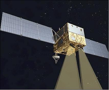
The minisatellites are based on the CAST-968B bus of DFHSat (DFH Satellite Co Ltd.) of CAST (China Academy of Space Technology), Beijing and by the China Aerospace Science and Technology Corporation. The spacecraft are 3-axis stabilized.
Each spacecraft (HJ-1A, HJ-1B) has a launch mass of 470 kg. The size is 1.2 m x 1.1 m x 1.03 m. The spacecraft design life is 3 years.
Unfortunately, there is no more spacecraft description available.
Launch
A Long March-2C (CZ-2C) launch of two spacecraft, HJ-1A and HJ-1B, took place on Sept. 5, 2008 (UTC). The launch site was TSLC (Taiyuan Satellite Launch Center), located in the northwest part of the Shanxi Province, China.
Orbit: Sun-synchronous circular orbit, altitude = 650 km, inclination = 97.95º, LTDN (Local Time of Descending Node) equator crossing at 10:45 hours.
HJ-1A and HJ-1B are in a coplanar orbit with a phasing of 180º.
In the final stage of the constellation, 4 satellites will be distributed in the same orbital plane at phase angles of 90º.
RF communications of HJ-1A: The TT&C communication is in S-band while the payload data are transmitted in X-band at a data rate of 120 Mbit/s.
RF communications of HJ-1B: The TT&C communication is in S-band while the payload data are transmitted in X-band at a data rate of 60 Mbit/s.
Three ground receiving stations for HJ-1 satellites are located in Miyun (Beijing), Kashi and Hainan, covering the entire land area of China and its surrounding countries and regions. CRESDA (China Center for Resource Satellite Data and Application) is responsible for the processing and analysis of the imagery.

Mission Status
• According to WMO OSCAR, the satellites HJ-1A and HJ-1B are operational in 2017. 12)
• Both spacecraft, HJ-1A and HJ-1B, are in nominal operation in 2015, six years after commissioning. 13)
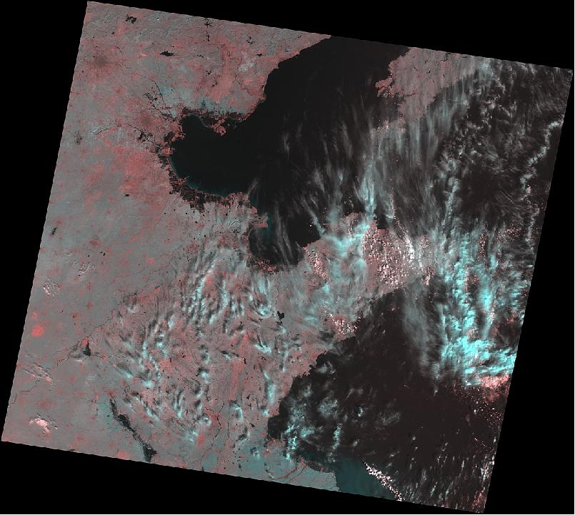
• Jan. 2015: The radiometric stability of satellite sensors is crucial for generating highly consistent remote sensing measurements and products. We have presented a radiometric responsivity tracking method designed especially for optical sensors without on-board calibration systems. Using a temporally stable desert site with high reflectance, the sensor responsivity was simulated using the Second Simulation of the Satellite Signal in the Solar Spectrum (6S) radiative transfer model (RTM) with information from validated MODIS atmospheric data. Next, radiometric responsivity drifting was identified using a linear regression of the time series BRDF (Bidirectional Reflectance Distribution Function) normalized coefficients. 15)
The proposed method was applied by CRESDA (China Center for Resources Satellite Data and Application) to the Chinese HJ-1A/-1B CCD sensors, which have been on-orbit operations for more than 5 years without continuous assessment of their radiometric performance. Results from the Dunhuang desert site between 2008 and 2013 indicated that the CCD sensors degraded at various rates, with the most significant degradation occurring in the blue bands, ranging from 2.8% to 4.2% yr-1. The red bands were more stable, with a degradation rate of 0.7-3.1% yr-1. A cross-sensor comparison revealed the least degradation for the HJ-1A CCD1 (blue: 2.8%; green: 2.8%; red: 0.7%; and NIR: 0.9% yr-1), whereas the degradation of HJ-1B CCD1 was most pronounced (blue: 3.5%; green: 4.1%; red: 2.3%; and NIR: 3.4% yr-1).
The tracking results are valuable for earth observation applications when time series HJ-1A/-1B CCD data are used which calls for effective correction of sensor degradation, and when data from different sensors are integrated due to inconsistency of varied radiometric responsivity.
• May 2014: The HJ-1 A/B satellites have now worked more than 5 years, and their payloads are operating well, while the application of HJ-1C is very limited into qualitative analysis due to the severe damaged antenna. 16)
• Both spacecraft are in nominal operation in 2012. 17)
• Both spacecraft are in nominal operation in 2010. The spacecraft play an important role in disaster monitoring next to their role in nominal Earth observations. 18)
China, a member of the International Charter "Space and Major Disasters", provided imagery of the HJ-1A and HJ-1B spacecraft to the relief authorities in Haiti after the devastating Haiti earthquake in January 2010.
• On April 1, 2009, the imagery of both spacecraft (HJ-1A and HJ-1B) was declared operational for the user community. 19) 20)
Sensor Complement
The sensor complement of the HJ-1A and HJ-1B spacecraft consists of three kinds of optical devices. The optical devices are: Wide View CCD Cameras (WVC), Infrared Multispectral Scanner (IRMSS), and the Hyperspectral Imager(HSI).21) 22)
The configuration of instruments onboard HJ-1A and HJ-1B satellites is as follows:
• HJ-1A satellite includes two CCD optical cameras (WVC) and one hyperspectral imager (HSI)
• HJ-1B satellite includes two CCD optical cameras (WVC) and one infrared multispectral scanner (IRMSS).
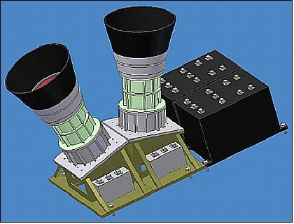
The two CCD cameras work together to form a 700 km wide swath. Each CCD camera has three visible bands (430-520 nm, 520-600 nm, and 630-690 nm) and a near-infrared band (760-900 nm). The spatial resolution of the CCD camera is 30 m.
Satellite | Instrument | Bands | Spectral range | Resolution | Swath width | Repeat cycle |
HJ-1A | WVC | 4 | 0.43-0.90 µm | 30 m | 700 km | 4 days |
HSI | 115 | 0.45 - 0.95 µm | 100 m | 50 km | 4-31 days (side looking ±30º) | |
HJ-1B | WVC | 4 | 0.43-0.90 µm | 30 m | 720 km | 4 days |
IRMSS | 4 | 0.75-1.10 µm | 150 m | 720 km | 4 days |
WVC (WIDE View CCD Cameras)
Instrument | CCD detector (pushbroom type) |
Spectral bands (4), µm | B1=0.43-0.52, B2=0.52-0.60, B3=0.63-0.69, B4=0.76-0.90 |
Spatial resolution | 30 m |
Swath width | 360 km x 2 = 720 km (double swath observation provided by parallel camera mounts) |
Aspect angle | 31º |
SNR (Signal-to-Noise Ratio) | ≥ 48 dB |
Data quantization | 8 bit |
Design life | ≥ 3 years |
HIS (Hyperspectral Imager)
The HIS instrument was designed and developed at the XIOPM (Xi'an Institute of Optics and Precision Mechanics) of CAS in Xi'an Shaanxi, China. 23) 24)
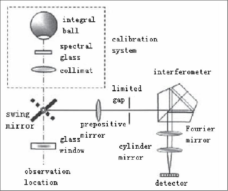
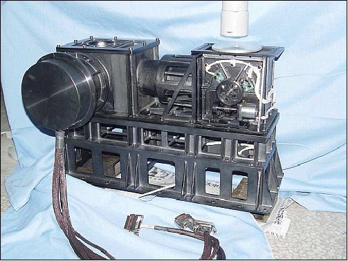
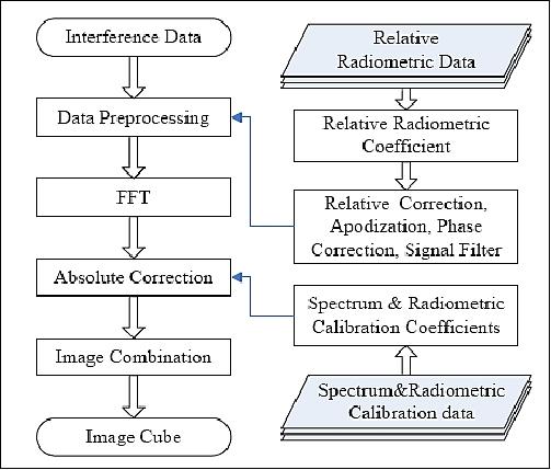
The HSI is composed of an interferometer, Fourier mirror, a calibration system, swing mirror, a detector array and some other components.
Instrument type | Hyperspectral imager, pushbroom type |
Spectral range (VNIR) | 0.45-0.95 µm |
No of bands | 110-128 |
Spatial resolution | 100 m |
Swath width | 50 km |
Aspect angle (cross-track looking capability) | ±30º |
SNR | 50-100 dB |
Data quantization | 12 bit |
Design life | ≥ 3 years |
The HIS instrument is carried by the HJ-1A satellite with a ground swath width of 50 km, the resolution of the ground pixels is 100 m, includes 110-128 spectral bands, has ± 30 ° side observing ability and calibration function on satellite.
IRMSS (Infrared Multispectral Scanner)
The instrument provides four bands in the spectral regions of: NIR (Near Infrared), SWIR (Short Wave Infrared) and TIR (Thermal Infrared).
The optomechanical instrument is of IRMSS heritage flown on the CBERS-1 (ZY-1) satellite.
Instrument type | Whiskbroom type scanning detection |
Spectral region | 0.75 - 12.5 µm |
No of bands | 4 |
Spectral ranges (µm) | NIR: 0.75-1.10 |
Spatial resolution | 150 m (NIR, SWIR1, SWIR2) |
Swath width | 720 km |
Aspect angle | ±29º |
SNR | - |
Data quantization | 10 bit |
Design life | ≥ 3 years |
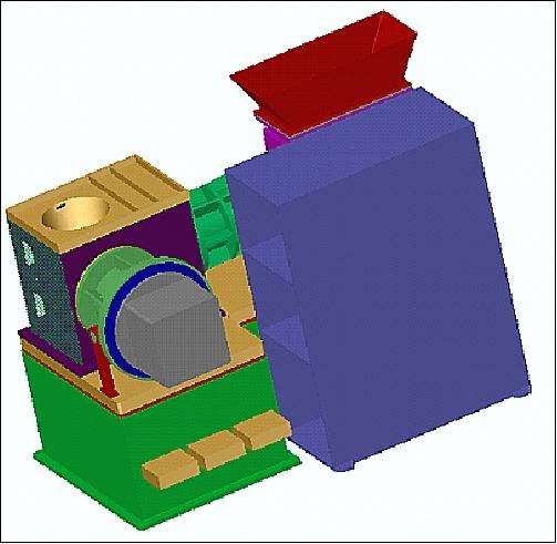
The IRMSS instrument is flown on the HJ-1B satellite; it features a swath width of 720 km, the spatial resolution is 150 m or 300 m (TIR).
HJ-1C (Huan Jing-1C / Environment-1C) Spacecraft with SAR Payload
The platform for the SAR spacecraft is based on the CAST-2000 bus with necessary modifications and upgrades.The satellite predicted operational life is three years. This is the first civil SAR (Synthetic Aperture Radar) system of China. 25) 26) 27)
Total mass of spacecraft | ~890 kg ( including 200 kg of SAR payload) |
AOCS | - Pointing accuracy: ≤ 0.1º (3σ) |
RF communications of payload data | - CCSDS standard is used to format compressed raw data and its auxiliary data |
RF communications | USB (Unified S-band) of TT&C support |
Power supply | - Use of GaAS/Ge solar cells; power of 1.1 kW (BOL), 0.8 kW EOL) |
Spacecraft design life | 3 years (reliability is 0.6) |
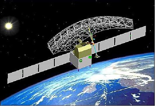
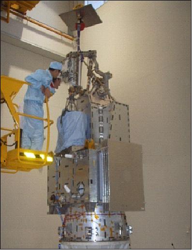
RF communications: X-band payload data transmission with QPSK modulation. The downlink data rate is of 2 x 160 Mbit/s. Use of the CCSDS standard to format the compressed raw data and its auxiliary data. An on board data storage capacity of 40 Gbit is provided.
Launch
The HJ-1C spacecraft was launched on Nov. 18, 2012 (UTC) on a Long March 2C vehicle (CZ-2C). The launch site was TSLC (Taiyuan Satellite Launch Center), located in the northwest part of the Shanxi Province, China. 28)
Orbit: Sun-synchronous circular dawn-dusk orbit, altitude = 502 km, inclination = 97.3º, period = 94 minutes, LTDN (Local Time on Descending Node) at 6:00 hours, repeat cycle = 31 days.
The secondary payloads on this flight were:
• NewTech-1 (New Technology Demonstration Satellite-1) of CASC
• HummerSat-1 (a minisatellite of 160 kg) of CAST (Chinese Academy of Space Technology)
• HummerSat-1A (a microsatellite of 30 kg) of CAST
Mission Status
• According to WMO OSCAR, the HJ-1C spacecraft is operational as of 2017 (Ref. 12).
• Only limited functionality is availaböle due to a damaged antenna of the SAR-S instrument.
Sensor Complement
SAR-S
The S-band SAR instrument has been developed with the assistance of NPO Mashinostroyenia & Vega Corp., Russia. A technical description of SAR instrument is not available.
Center frequency | 3.13 GHz (S-band), corresponds to a wavelength of 9.6 cm |
Spatial resolution | 20 m (4 looks) |
Swath width | 100 km |
Radiometric resolution | 3 dB |
Antenna polarization | Single mode (HH or VV) |
Incidence angle | 25-47º |
Data quantization | 4 bit (BAQ compression) |
Data location error | ≤ 500 m |
References
1) Xingling Wang, Gang Wang , Yan Guan, Quan Chen, Lianru Gao, "Small Satellite Constellation for Disaster Monitoring in China," Proceedings of IGARSS 2005, Seoul, Korea, July 25-29, 2005
2) J. Gao, "Concept and International Collaboration on China's Environmental and Disaster Monitoring Satellite System (EDMSS)," UNESCAP Meeting, Bangkok, Thailand, June 22-24, 2005
3) "Third Party Candidate Mission Evaluation Report (TP-CMER) 2005," ESA/PB-EO(2005)1 10, Oct. 11, 2005
4) J. Liu, "Earth Observation, A China Overview," EOBN 2008 (Earth Observation Business Network), May 13-14, 2008, Richmond, BC, Canada
5) Ming Li, "On-Orbit Performance and Application of Chinese Environment and Disaster Monitoring Satellite HJ-1A and HJ-1B," Proceedings of the 60th IAC (International Astronautical Congress), Daejeon, Korea, Oct. 12-16, 2009, IAC-09.B1.I.16
6) "Small Satellite Constellation for Environment and Disaster Monitoring and Forecasting (SSCEDMF)," UN-OOSA (United Nations- Office for Outer Space Affairs), UN-SPIDER (UN - Platform for Space-based Information for Disaster Management and Emergency Response) Workshop, June 2-4, 2009, Vienna, Austria, URL: http://www.oosa.unvienna.org/pdf/pres/copuos2009/tech-12.pdf
7) Xingchao Li, "Chinese Thermal instruments: CBERS and HJ-1B," Wuhan University, Oct. 123-18, 2008, URL: http://dragon2.esa.int/landtraining2008/pdf/D1L4b_Thermal_Li.pdf
8) L. Wang, S. Yang, X. Xi, W. Li, "Applications of Small Satellite Constellation for Environment and Disaster Monitoring and Forecastring (SSCEDMF) in Disaster Monitoring and Assessment," ISPRS, International Conference on Geo-spatial Solutions for Emergency Management and the 50th Anniversary of the Chinese Academy of Surveying and Mapping, Beijing, China, Sept. 14-16, 2009, URL: http://www.isprs.org/proceedings/XXXVIII/7-C4/264_GSEM2009.pdf
9) Jing Li, "Capacity Building of DRR in China, Building a Local Government Alliance for Disaster Risk Reduction and Expert Group Meeting on ICT for Disaster Risk Reduction," Aug. 11-13, 2009, Incheon, Korea, URL: http://www.unapcict.org/ecohub/resources/Capacity-Building-of-DRR-in-China.pdf
10) Xingfa Gu, Tao Yu, "China Earth Observation Satellite Program: future systems for agricultural monitoring," Workshop on 'Developing an Agricultural Monitoring System of System,' Feb. 11-13, 2009, Beijing, China, URL: http://tinyurl.com/oxlkwsh
11) Suju Li, Byung-Sam Kang , Guoxiang Wu, "Collaborative Development of a Regional Disaster Management Support Platform on Space-based Information Sharing and Analysis," ESCAP (Economic and Social Commission for Asia and the Pacific) Technical Paper, IDD/TP-09-03 (Version 1.0), Sept. 2009, URL: http://www.unescap.org/idd/working%20papers/IDD_TP_09_03_of_WP_7_2_906.pdf
12) https://www.wmo-sat.info/oscar/satellites/view/169
13) "HJ-1A, Hj-!B," WMO OSCAR (Observing Systems Capability Analysis and Review Tool), 2015, URL: http://www.wmo-sat.info/oscar/satellites/view/170
14) "HJ-1A/B/C," CREDA, Nov. 3, 2015, URL: http://www.cresda.com/EN/satellite/7117.shtml
15) Jian Li, Xiaoling Chen, Liqiao Tian, Lian Feng, "Tracking radiometric responsivity of optical sensors without on-board calibration systems case of the Chinese HJ-1A/1B CCD sensors," OSA (Optical Society of America) 2015, 26 Jan 2015, Vol. 23, No. 2, DOI:10.1364/OE.23.001829, Optics Express 1829, URL: http://www.opticsinfobase.org/DirectPDFAccess/2F3F881D-0872-15ED-4FF8EFEB3B1FF688_310757/oe-23-2-1829.pdf?da=1&id=310757&seq=0&mobile=no
16) Shaohua Zhao, "Application of the moderate and high spatial resolution satellite in China environmental protection," Report of the 42 nd Meeting of the Coordination Group for Meteorological Satellites (CGMS-42, CNSA-WP-05), Guangzhou, China, 19-23 May 2014, URL: http://www.eumetsat.int/website/wcm/idc/idcplg?IdcService
=GET_FILE&RevisionSelectionMethod=LatestReleased&Rendition=Web&dDocName=CWPT_1223
17) Guoyuan Li, Huabin Wang , Canhai Li, "Ortho-Rectification of HJ-1A/1B Multispectral Image Based on the GCP Image Database," Proceedings of the 22nd Congress of ISPRS (International Society of Photogrammetry and Remote Sensing), Melbourne, Australia, Aug. 25 - Sept. 1, 2012, URL: http://www.int-arch-photogramm-remote-sens-spatial-inf-sci.net/XXXIX-B4/335/2012/isprsarchives-XXXIX-B4-335-2012.pdf
18) "HJ-1 Small Satellites and Application for Disaster Reduction," NDRCC (National Disaster Reduction Center of China), 47th Session of STSC (Scientific and Technical Subcommittee), UNOOSA, Vienna, Austria, Feb. 8-19, 2010, URL: http://www.oosa.unvienna.org/pdf/pres/stsc2010/tech-26.pdf
19) "Satellites Will Help Predict Disasters," Space Mart, April 2, 2009, URL: http://www.spacemart.com/reports/Satellites_Will_Help_Predict_Disasters_999.html
20) "HJ-A/B of Environment and Disasters Monitoring Microsatellite Constellation delivered to the users," CNSA, April 1, 2009, URL: https://web.archive.org/web/20160424042053/http://www.cnsa.gov.cn:80/n615709/n620682/n639462/168207.html
21) Fan Shiming, Wang Yang, Jiang Zhijun, Zhou Zhixiang, "China Earth Observation Satellites Data System and Model Research of Data Applications," Proceedings of the 59th IAC (International Astronautical Congress), Glasgow, Scotland, UK, Sept. 29 to Oct. 3, 2008, IAC-08.B1.4.2
22) China Centre for Resources Satellite Data and Application (CRESDA), URL: http://www.cresda.com/n16/n92006/n92066/n98627/index.html
23) "The Hyperspectral Imager of China's First Environment Satellite," July 9, 2009, URL: https://web.archive.org/web/20141217032403/http://english.opt.cas.cn/rh/rps/200907/t20090709_22423.html
24) Xiang Zhao, Zhengqing Xiao, Qian Kang, Qing Li, Li Fang, "Overview of the Fourier Transform Hyperspectral Imager (HSI) boarded on the HJ-1 Satellite," Proceedings of IGARSS (IEEE International Geoscience and Remote Sensing Symposium) 2010, Honolulu, HI, USA, July 25-30, 2010
25) R. Zhang,, "Study on the Relationship Between SAR Imaging and Small Satellite System Parameters," Proceedings of the 57th IAC/IAF/IAA (International Astronautical Congress), Valencia, Spain, Oct. 2-6, 2006, IAC-06-B5.6.03
26) Ming Li, "From Demonstration to Application - China CAST2000 SmallSat Platform and its Fleet," Proceedings of the 57th IAC/IAF/IAA (International Astronautical Congress), Valencia, Spain, Oct. 2-6, 2006, IAC-06-B5.6.12
27) Yi-Rong Wu, Minhui Zhu, Wen Hong, "SAR Activities in P. R. China," 6th European Conference on Synthetic Aperture Radar (EUSAR 2006), May 16-18, 2006, Dresden, Germany
28) Rui C. Barbosa, "Chinese Long March 2C lofts Huanjing-1C into orbit," NASA, Nov. 18, 2012, URL: http://www.nasaspaceflight.com/2012/11/chinese-long-march-2c-huanjing-1c-into-orbit/
The information compiled and edited in this article was provided by Herbert J. Kramer from his documentation of: "Observation of the Earth and Its Environment: Survey of Missions and Sensors" (Springer Verlag) as well as many other sources after the publication of the 4th edition in 2002. - Comments and corrections to this article are always welcome for further updates (eoportal@symbios.space).
Spacecraft Mission Status 1A/B Sensor Complement HJ-1C References Back to Top