HydroGNSS/Scout-2
EO
ESA
Ocean
Land
HydroGNSS (Hydrological Global Navigation Satellite System) is a Scout concept mission selected by ESA to collect data on the hydrological climate variables of soil moisture content, wetland inundation, soil freeze and thaw states, and above ground forest biomass, through a technique known as Global Navigation Satellite System Reflectometry.
Quick facts
Overview
| Mission type | EO |
| Agency | ESA, UKSA |
| Mission status | Approved |
| Measurement domain | Ocean, Land, Snow & Ice |
| Measurement category | Vegetation, Sea ice cover, edge and thickness, Soil moisture, Ocean surface winds, Ocean wave height and spectrum |
| Measurement detailed | Sea-ice cover, Soil moisture at the surface, Wind speed over sea surface (horizontal), Sea-ice thickness, Significant wave height, Above Ground Biomass (AGB), Sea-ice Concentration, Freeze/thaw, Surface inundation |
| Instruments | SGR-ReSI-Z |
| Instrument type | Other |
| CEOS EO Handbook | See HydroGNSS/Scout-2 summary |
Summary
Mission Capabilities
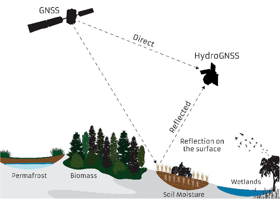
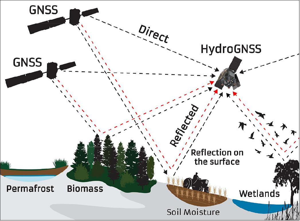
HydroGNSS will carry a single instrument, the HydroGNSS receiver. This instrument is a radio occultation receiver, that uses a bi-static radar concept with existing satellite systems such as GPS or ESA’s Galileo to collect reflected L-band microwave signals that have picked up the geophysical imprint of the Earth’s surface. It aims to collect information on soil moisture content, wetland inundation, soil freeze and thaw states, and above ground forest biomass.
Performance Specifications
The HydroGNSS reflectometer will be in continuous operation for three years, with potential for a two year extension. The instrument will collect dual polarisation signals at dual-frequency, have sensitivity in the range of 0.7 - 3.8 dB/10%, with a theoretical spatial resolution of 2 - 7 km. It will collect L-band GNSS signals, with a wavelength of 1565 nm - 1625 nm and a frequency of 1 - 2 GHz. HydroGNSS will operate in a Low Earth Orbit (LEO).
Space and Hardware Components
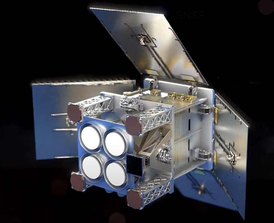
HydroGNSS will use the SSTL-21 bus, the smallest of the SSTL-Micro series, which will be manufactured by Surrey Satellite Technology Ltd. (SSTL). The bus will weigh approximately 40 kg. Payload data will be downlinked at the Svalbard satellite ground station, which allows Payload Data Ground Segment (PDGS) data processing and rapid dissemination of both data and products to users.
Overview
HydroGNSS, also known as Scout-2, is a mission concept selected by ESA as a Scout candidate, and consists of a 40 kg satellite that addresses land hydrological parameters using the technique of Global Navigation Satellite System (GNSS) Reflectometry, a form of bistatic L-band radar using satellite navigation signals as a radar source. The four targeted essential climate variables (ECVs) are of established importance to our understanding of the climate evolution and human interaction, and comprise of soil moisture, inundation / wetlands, freeze / thaw (notably over permafrost), and above ground biomass. 1)
The technique of GNSS Reflectometry shows potential over all geophysical surfaces for low cost measurement of ocean winds, ocean roughness, soil moisture, flood & ice mapping, and other climate and operational parameters. SSTL developed and flew the SGR-ReSI GNSS remote sensing instrument on the 160 kg UK TechDemoSat-1 (TDS-1) in July 2014 and, with sponsorship from ESA, collected data until TDS-1’s drag-sail was deployed in May 2019. TDS-1 was a precursor for NASA's CYGNSS mission which uses the SGR-ReSI on its 8-microsatellite constellation for sensing hurricanes. The datasets from TDS-1 have been released via the MERRByS website, and include ocean wind speed measurements and ice extent maps from National Oceanography Centre’s C-BRE inversion. At the same time, researchers recognized the benefits of GNSS reflectometry overland, including the unique capability to sense rivers under forest canopies to a high resolution.
HydroGNSS has been proposed for the ESA Scout mission opportunity by SSTL and a team of partners with a broad range of experience in GNSS technology, GNSS-Reflectometry modelling and applications, and Earth Observation from GNSS-R measurements. The instrument takes significant steps forward from previous GNSS-R experiments by including capability in dual polarisation, dual-frequency and coherent reflected signal reception, that are expected to help separate out ECVs and improve measurement resolution. The satellite platform is the 40 kg SSTL-Micro, which has improved attitude determination and a high data link to support the collection of copious quantities of scientific data with a short time delay. HydroGNSS builds upon the growing GNSS-R knowledge gained from UK-DMC, TDS-1, and ORORO / DoT-1, and is anticipated to generate a new research data set in GNSS Earth Observation, specifically targeting land and hydrological applications.
State of the art satellites that target soil moisture such as ESA SMOS and NASA SMAP are highly valued by scientists and operational weather forecasters, but will be expensive to replace. As evidenced by TDS-1 and CYGNSS, HydroGNSS will be able to take GNSS-R measurements using GNSS signals as a radar source, reducing the size of the satellite platform required. The forward scatter L-band nature of the measurement means that they are complementary to other techniques, and HydroGNSS brings further new measurement types compared to TDS-1 and CYGNSS. The small size and low recurring cost of the HydroGNSS satellite design opens the door to a larger constellation that can further improve spatial and temporal global hydrological measurements to an unprecedented resolution, invaluable to the better understanding of our climate.

In May 2022, HydroGNSS was announced as the first contracted small satellite mission under the Scout programme as an element in ESA’s FutureEO programme. ESA's Scout missions consist of one or several small satellites for rapid prototyping and demonstration of novel Earth observation techniques for Earth science and related non-commercial applications. Scouts demonstrate disruptive sensing techniques or incremental science, while retaining the potential to be subsequently scaled up in larger missions or implemented in future ESA Earth Observation programmes. 2)
The original submission assumed two HydroGNSS satellites within the required budget of <€30 million. The initial Scout funding is for a single HydroGNSS satellite with the system designed to support a constellation of HydroGNSS satellites.
HydroGNSS uses novel dual frequency, dual polarisation L-Band GNSS Reflectometry to target four hydrological Essential Climate Variables (ECVs) namely: soil moisture, wetlands / inundation, freeze / thaw state and above ground biomass (Figure 2).
The satellite is designed to support an on orbit operational life time of 4.5 years. While continuing to explore the technique of GNSS-Reflectometry the mission will lay the foundations for a future constellation offering high spatial-temporal resolution observations of the Earth’s weather and climate.
HydroGNSS will complement other missions sensing soil moisture and forest biomass such as ESA’s SMOS and Biomass, Copernicus Sentinel-1 and NASA’s SMAP missions. The project also supports the UK National Space Strategy Goal 5 by using space to tackle the global challenge of climate change.
Background: Hydrological Parameters
The World Meteorological Organisation states: “Global hydrological conditions of floods and droughts as well as potential conflicts in water use are some of the greatest challenges and threats facing the world’s population. Some 20 million people are at risk from flooding with the associated damage costing nearly US$80 billion; this could rise to 50 million people affected in just 15 years time, according to the World Resources Institute.” 3). Furthermore, water is a natural resource vital to climate, weather, and life on Earth, and unforeseen global variability in hydrology poses one of the greatest threats to the world’s population.4)
Water manifests itself in or on the land in different ways, for example, moisture in the ground, wetlands and rivers, snow and ice, and vegetation. Global knowledge of land water content and state importance in its different forms define the HydroGNSS primary mission objectives to measure, using reflected GNSS Signals:
• Soil Moisture – including use of dual-polarised reflections to help separate roughness and vegetation effects from soil moisture. Better vegetation penetration and higher resolution may be possible using coherent channel and second frequency reflections. This knowledge is needed for weather forecasting, hydrology, agricultural analysis, and wide scale flood prediction.
• Inundation / Wetlands – including use of the coherent channel to achieve higher resolution. Better vegetation penetration and higher resolution may be possible using second frequency reflections. This knowledge is important as the fragile water-dependent ecosystems in wetlands, often hidden under forest canopies, can also turn into sources of methane, whilst elsewhere an over-supply of water can lead to inundation and destructive flooding.
• Soil Freeze/Thaw state – especially over permafrost regions, identifying the date in the year of state change. Better sensitivity to freeze/thaw may be possible using coherent channels. The freeze / thaw state affects the surface radiation balance and the exchange rates of latent heat and carbon with the atmospheric boundary layer, and acts as a tracer for sub-surface permafrost behaviour in high latitudes.
• Forest Above Ground Biomass – using attenuation of signals in combination with knowledge of underlying surface and soil moisture characteristics. This knowledge feeds into the understanding of carbon stock in forests and a sink in the carbon dioxide cycle, and also has a coupling to biodiversity.
The four aspects of hydrology: soil moisture, inundation / wetlands, soil freeze / thaw and above ground biomass, are four aspects of the hydrology ECVs, as identified by the Global Climate Observing System, GCOS. ECVs are defined in association with the United Nations Framework Convention on Climate Change (UNFCCC), the Intergovernmental Panel on Climate Change (IPCC) and the World Meteorological Organization (WMO) in order to help understand and predict climate change, to guide mitigation measures, and to assess risks. Specific committees and programmes address the need for measurements of soil moisture (including freeze / thaw and inundation states), permafrost and biomass, while wetlands are among the targets of the Climate Change Initiative (CCI) Land Cover, and play a role as a primary source for greenhouse gases. Increasingly complex and accurate models are used to characterise and forecast hydrological processes: Earth System Models (ESMs) are used for climate, and Numerical Weather Prediction (NWP) models for weather forecasting. These models have a requirement for hydrological observational data to be assimilated to ensure correspondence with the complexity of the real world.
These measurements can also assist with the UK Net Zero Strategy 5) by monitoring Biomass, flooding and providing farmers with information about soil moisture.
HydroGNSS also has the secondary mission objective to measure ocean wind speed and ice extent, which address GCOS ECVs Ocean Surface Stress and Sea Ice Extent. Other new parameters and products may be investigated using the repertoire of new GNSS-R measurement types (e.g. ocean mean square slope, wind direction, microplastics in the ocean, Chl-a, ice concentration, snow water equivalent, sea ice thickness, and inland water bodies). These objectives will not drive the instrument and mission development and operation.
Uniqueness and Complementarity
HydroGNSS fits well into the context of current and future institutional EO missions and addresses shortcomings and demonstrates how small rapid satellites can assist in adding valuable measurements to track climate variables.
As illustrated in Figure 3, HydroGNSS offers to augment current capabilities through additional density of measurements, adding new synergic ECV observations that extend from current sensing techniques, offering timely continuity over a potential gap in L-band missions, reaching geographic areas not covered by Biomass, and demonstrates a low-cost small satellite approach that is sustainable for the future.
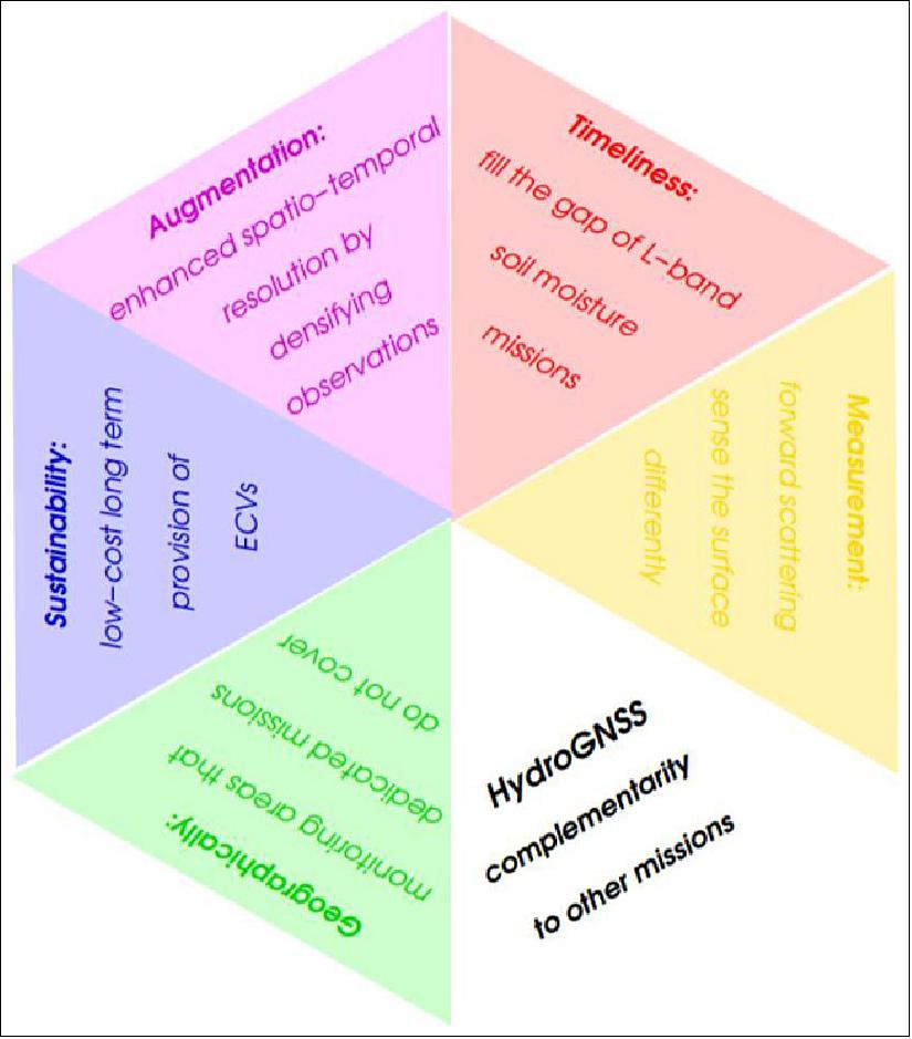
The SMOS and SMAP missions provide global coverage of soil moisture at L-band through radiometry, achieving resolutions of around 30-40 km, but both have exceeded their design life and do not have immediate replacements.
As an L-Band forward scattering sensor, the measurements from HydroGNSS are expected to have strengths and weaknesses compared to other data sources. The greatest value of the HydroGNSS mission will be achieved if results from a HydroGNSS constellation can be used to complement other missions, as encouraged by international collaborations such as the Global Earth Observations (GEO).
Six small HydroGNSS satellites would be expected to match the coverage of SMOS at a fraction of the cost, while exceeding its resolution. Further HydroGNSS satellites could be added at low cost to achieve unprecedented spatial and temporal measurements of the globe. Using techniques compatible with small satellites, HydroGNSS offers medium to high resolution proving the value of small satellites.
Spacecraft
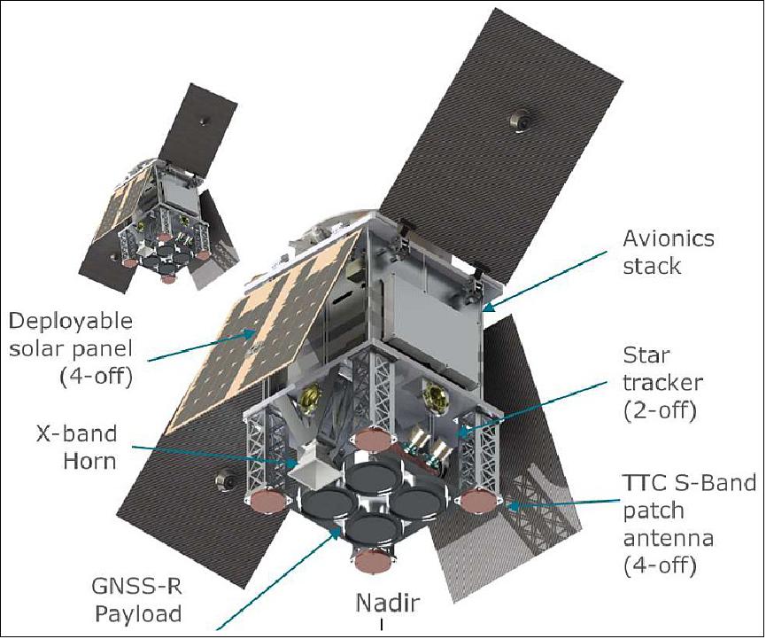
The platform that has been selected for HydroGNSS is the ‘SSTL-21’, which is the smallest family member of the ‘SSTL-Micro’ platform. This is a highly capable platform, but small enough to maintain the low cost of a future constellation (Figure 4).
To best support the mission aims and objectives, over geographically diverse targets the platform is chosen to offer the HydroGNSS mission 100% duty cycle to allow payload operation continuously. The satellite also supports a large data store and a high data throughput to support the data volumes generated with these 24/7 payload operations.
Mission Status
• March 30, 2021: Surrey Satellite Technology Ltd (SSTL) is pleased to confirm that The European Space Agency (ESA) has selected ‘HydroGNSS’ as the second Scout Earth Observation small satellite mission.
• October 11, 2021: ESA has signed a contract with Surrey Satellite Technology Ltd to build the HydroGNSS Scout mission.
• September 8, 2022: EECL (European Engineering & Consultancy) of Kingston-Upon-Thames, UK, an engineering consultancy providing design, manufacturing & test services to the satellite & aerospace sector, has signed a contract to supply low noise amplifiers (LNA) to Surrey Satellite Technology (SSTL) for the front-end receiver of the European Space Agency (ESA) HydroGNSS Scout Earth Observation payload.
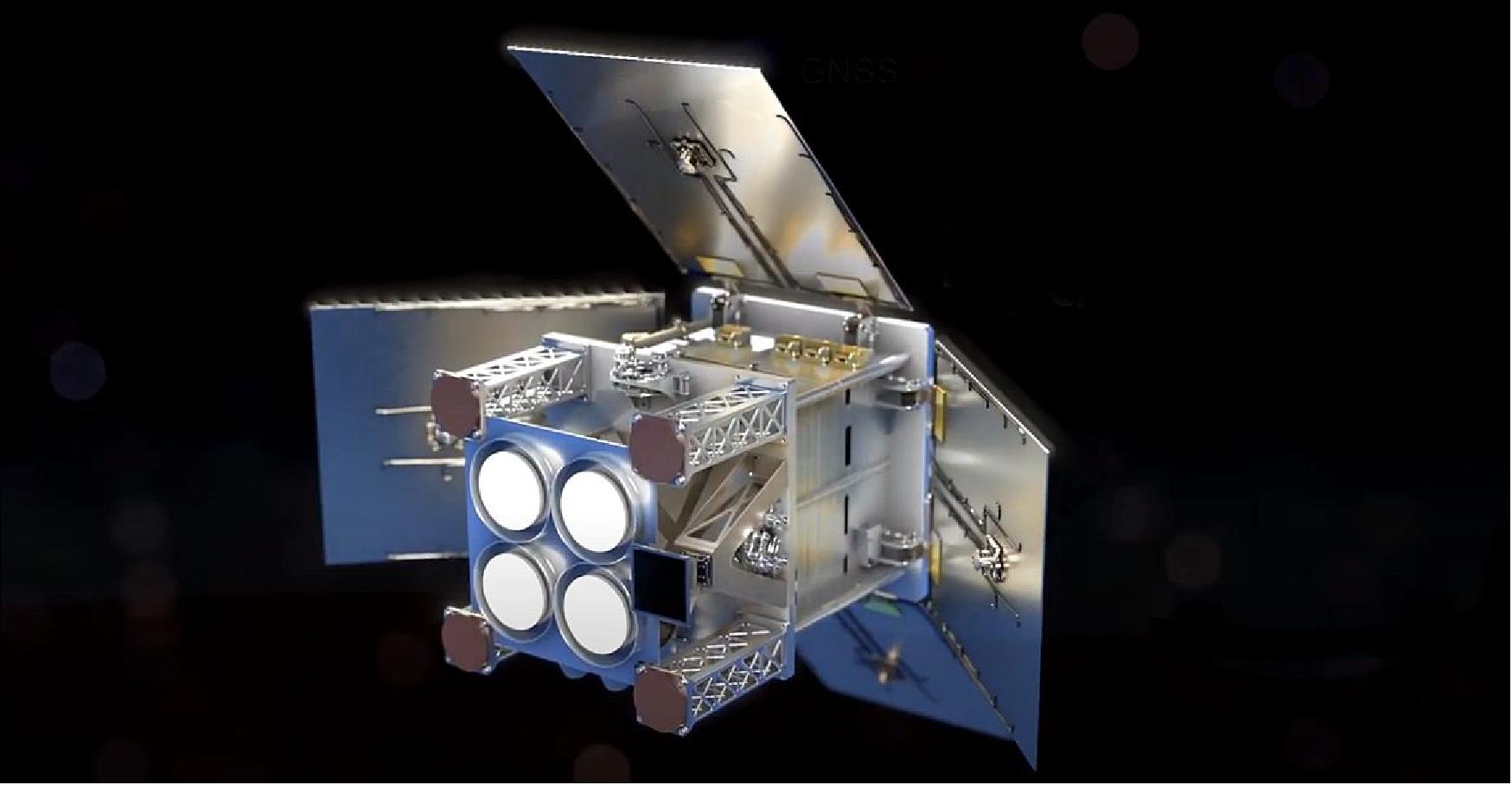
Figure 7: The HydroGNSS mission comprises two 40 kg satellites that collect data continually in near-polar orbits, taking hydrological measurements over the whole globe. The HydroGNSS mission concept makes advanced use of new GNSS Reflectometry techniques such as Galileo signals, dual polarisation, and coherent signal acquisition to measure 4 Essential Climate Variables (ECVs) over land: Soil Moisture, inundation, permafrost freeze/thaw, and biomass. HydroGNSS has been down-selected by ESA for a concept study, and the finally selected Scout mission will commence in 2021 (video credit: SSTL)
Sensor Complement
The HydroGNSS sensor complement will include a single instrument, the GNSS Reflectometer, a radio-occultation receiver. The Reflectometer makes use of existing GNSS (Global Navigation Satellite System) systems in medium Earth orbit (MEO), such as GPS and Galileo, to collect measurements of key hydrological climate variables, including soil moisture, freeze–thaw state over permafrost, inundation and wetlands, and above-ground biomass. This will be achieved through the application of a bi-static radar concept, whereby the low-power L-band microwave navigation signals continually transmitted by MEO GNSS satellites reflect off of the Earth, picking up the geophysical imprint of the surface. These reflected signals are then intercepted by the GNSS reflectometer, allowing sensing of the geophysical properties of the Earth’s surface. A single observatory can continuously collect reflected signals from multiple sources, with the GPS and Galileo constellations already providing 60 such sources.
HydroGNSS aims to monitor four main climate variables: soil moisture, inundation/wetlands, above ground biomass and soil freeze, thaw and permafrost. GNSS reflectometry (GNSS-R) is effective in sensing soil moisture content, as specular reflectivity is based on soil permittivity. The GNSS Reflectometer sensitivity, in the range of 0.7-3.8 dB/10%, is comparable to monostatic radar systems operating in similar electromagnetic bands, and is theoretically capable of reaching a spatial resolution of 2-7 km, a significant improvement on spaceborne microwave radiometers. GNSS-R is also capable of sensing inundation and wetlands, even through vegetation.
GNSS L-band signals have better penetration ability than standard C-band radar, and can thus sense strong reflecting surfaces through forest canopies. This ability is unique, and will help address current remote sensing limitations. The achievable spatial resolution for this variable will improve with reflection coherence, approaching the resolution of the Fresnel zone - 1 km for L-band signals. GNSS-R can also be used to monitor above ground biomass, as vegetation attenuates soil-reflected signals, creating an inverse correlation of the signal with biomass. However, the measurement of signals reflected from high-density biomass areas, due to extreme attenuation, is still challenging, as is the separation of above ground biomass from underlying soil characteristics.
Permafrost states cannot be directly observed by GNSS-R, due to their depth. Soil freeze and thaw states can still be observed, providing valuable insights for permafrost modelling. This is enabled by the lower permittivity of frozen soil compared to thawed, meaning that surface-reflected signals diminish in frozen conditions. Therefore, measured reflectivity is less related to subsurface conditions, as pertains to permafrost, than measurements by microwave radiometers.
Ground Segment
The HydroGNSS payload will be operated continuously for three years, with the option of a two year lifetime extension, at the end of which the satellite will be allowed to deorbit. Payload data will be downloaded at the Svalbard satellite ground station, allowing for the possibility of PDGS (Payload Data Ground Segment) data processing, enabling rapid dissemination of data and products to users. The payload data processing scheme is an evolution of MERRByS (Measurement of Earth Reflected Radio-navigation signals By Satellite) and entails: the reformatting of Level-0A and -0B data and preparation of concurrent metadata, the dissemination of Level-1 data to users, Level-2 processing to generate ECV (Essential Climate Variable) products and dissemination of these products, while Level-3 will consist of the creation of periodic product maps.
References
1) “An Introduction to the HydroGNSS GNSS Reflectometry Remote Sensing Mission.” IEEE Xplore, IEEE, 17 January 2019, https://ieeexplore.ieee.org/document/9456091. Accessed 4 November 2022.
2) “HydroGNSS | Small Satellite supplier.” Surrey Satellite Technology, https://www.sstl.co.uk/space-portfolio/missions-in-build/2022/hydrognss. Accessed 4 November 2022.
3) “Greenlight to HydroGNSS, ESA's second Scout mission.” Institute of Space Sciences (ICE-CSIC), 7 April 2021, https://www.ice.csic.es/technology/aeu/2-uncategorised/46-greenlight-to-hydrognss-esa-s-second-scout-mission. Accessed 4 November 2022.
4) “ESA - HydroGNSS.” European Space Agency, https://www.esa.int/ESA_Multimedia/Images/2021/03/HydroGNSS. Accessed 4 November 2022.
5) Cozzens, Tracy. “SSTL's HydroGNSS satellite gets green light for climate mission.” GPS World, 30 March 2021, http://gpsworld.com/sstls-hydrognss-satellite-gets-green-light-for-climate-mission/. Accessed 4 November 2022.