Spire Global Nanosatellite Constellation
EO
Atmosphere
Ocean
Atmospheric Temperature Fields
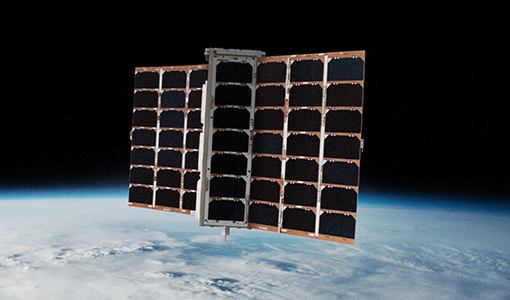
In 2014, commercial company Spire Global inaugurated the Lemur project with the launch of the Low Earth Multi-Use Receiver-1 (Lemur-1) prototype satellite on a Soyuz Rocket. The main objective of the mission was to demonstrate the satellite platform and support systems. Lemur-2 is a constellation of nano-satellites with 3U CubeSat platforms, designed to maintain up to 175 flight units. The program began in 2015 with the launch of four Lemur-2 nanosatellites, and over 180 flight units have been launched as of September 2024. Lemur-2 images are used to track maritime, aviation, and weather activity from space.
Quick facts
Overview
| Mission type | EO |
| Agency | Spire |
| Mission status | Operational (nominal) |
| Launch date | 03 Aug 2013 |
| Measurement domain | Atmosphere, Ocean |
| Measurement category | Atmospheric Temperature Fields, Cloud particle properties and profile, Multi-purpose imagery (ocean), Ocean topography/currents, Ocean surface winds, Atmospheric Winds, Ocean wave height and spectrum |
| Measurement detailed | Precipitation Profile (liquid or solid), Ocean imagery and water leaving spectral radiance, Cloud imagery, Cloud liquid water (column/profile), Atmospheric temperature (column/profile), Precipitation index (daily cumulative), Ocean dynamic topography |
| Instruments | AIRSAFE, STRATOS, SENSE |
| Instrument type | High resolution optical imagers, Space environment, Other, Communications, Data collection, Hyperspectral imagers, Radar altimeters |
| CEOS EO Handbook | See Spire Global Nanosatellite Constellation summary |
Related Resources
Summary
Mission Capabilities
Lemur-2 carries three instruments: STRATOS, SENSE and Automatic Dependent Surveillance Broadcast (ADS-B). STRATOS is the Spire Global Navigation Satellite System (GNSS) receiver for remote sensing and precision orbit determination used for weather model assimilation of radio occultation, space weather monitoring, ionosphere corrections for navigation and thermospheric density.
SENSE is a receiver for Automatic Identification System (AIS) signal reception used by maritime vessels to broadcast position information, providing worldwide tracking for maritime safety. The ADS-B was a new addition to the Lemur-2 nanosatellites that were launched from 2018 onwards. ADS-B tracks aircraft, providing their position, velocity, callsign and status.
Performance Specifications
Lemur-2 satellites are in a sun-synchronous orbit and have orbit altitudes ranging from 400 to 600 km with various orbit inclinations, depending on the launch of the satellites. STRATOS has an along-track resolution of approximately 200 km and an across-track resolution of approximately 1 km.
Space and Hardware Components
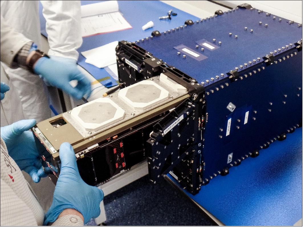
The nanosatellites, also known as CubeSats, are built by Spire. The CubeSats are integrated within a CubeSat deployer and are delivered to the International Space Station (ISS). A crew member transfers the CubeSat from the launch vehicle to the Japanese Experiment Module (JEM/Kibo) and performs a visual inspection for damage. During the deployment operations, the CubeSats are unpacked, mounted on the Japan Aerospace Exploration Agency (JAXA) Multi-Purpose Experiment Platform (MPEP) and placed on the JEM/Kibo airlock slide table for transfer outside the ISS. A crew member operates the JEM Remote Manipulating System (JRMS) to grapple and position for deployment. JAXA ground controllers provide specific commands to deploy the CubeSats.
Spire Global Nanosatellite Constellation
Spacecraft Launches Mission Status Sensor Complement References
The Lemur-2 nanosatellites are part of a remote sensing commercial satellite constellation of Spire Global Inc., San Francisco, CA, that provides global ship tracking and weather monitoring. The satellites in this investigation are deployed from both the ISS (International Space Station) and the visiting space vehicle, demonstrating the technology at a range of altitude bands. 1) 2)
Background
Spire Global, Inc.,previously called Nanosatisfi, is an American private company specializing in data gathered from a network of small satellites. Spire Global was founded in 2012 and opened offices in San Francisco. The company later opened offices in Glasgow (UK), Singapore, and in Boulder, CO. The company was founded to create Ardusat, a crowd-funded satellite, which was launched on August 3, 2013. 3) 4)
The company’s first three Ardusat satellites were named after a portmanteau of Arduino, the technology on which they were based, and satellite. In August 2014, it was announced that Ardusat was spun out of Spire and would focus on educational technology.
Spire Global inaugurated the Lemur project in 2014 with the launch of the Lemur-1 prototype satellite atop a Soyuz Rocket. The primary purpose for that mission was to demonstrate the satellite platform and support systems, not the operational payloads. In place of the meteorological & ship-tracking equipment, Lemur-1 featured a pair of Earth-observation payloads, a medium-resolution color camera and a low-resolution infrared imaging system.
Lemur-2 was inaugurated in 2015 with the launch of four satellites atop an Indian PSLV launcher, introducing the STRATOS and SENSE instruments. Over the course of the program, Spire Global plans to implement incremental improvements of the satellites and add more sensors. The next generation of Lemurs, debuting around 2018, will feature an ADS-B terminal for tracking of aircraft on a global scale.
• March 6, 2017: Ball Aerospace and Spire Global, Inc. are collaborating on a program on behalf of the National Geospatial-Intelligence Agency (NGA) to improve MDA (Maritime Domain Awareness) in the Arctic. Together, Ball and Spire are developing a data collection and analysis platform that monitors maritime traffic in the Arctic, which will enable improved awareness of vessel activity and behaviors. 5)
- “Ball and Spire’s collaboration demonstrates our abilities to seamlessly deliver to NGA relevant and actionable information critical to security, safety, the economy and the environment,” said Debra Facktor Lepore, Ball Aerospace’s vice president and general manager, strategic operations and commercial aerospace business unit. “For more than 30 years, Ball has delivered data analysis software and systems expertise to the United States Government, and the synergies with Spire will result in commercial solutions that continue to drive maximum effectiveness and affordability for our customers.”
- In association with NGA, Ball and Spire will leverage two existing commercial capabilities to create accurate, near real-time pictures of maritime activity in the Arctic. Spire’s constellation of nanosatellites capture Automatic Identification System (AIS) vessel tracking data over the most remote parts of the globe. The AIS data is then ingested into Ball’s cloud-based data analytics architecture and fused with other commercial Geospatial Intelligence (GEOINT) data to yield detailed profiles of vessel activity and establish benchmarks in vessel behavior.
- “This project will provide extraordinary insight into vessel traffic in the Arctic. Due to the remote nature of that region, Spire’s nanosatellites are an excellent way of generating Arctic maritime data with both fast revisit time and low latency,” said Peter Platzer, CEO of Spire. “Through the combination of our commercial nanosatellite constellation and Ball’s extensive experience in data exploitation and analytics, we expect to provide NGA with substantial improvements in Maritime Domain Awareness.”
- NGA ensures safety of navigation in the air and on the seas by maintaining the most current information and highest quality services for U.S. military forces and global transport networks. With ship traffic through Arctic routes projected to grow 250 percent by 2025 due to melting polar ice, the collaboration between Ball and Spire addresses a critical gap in monitoring maritime vessel patterns.
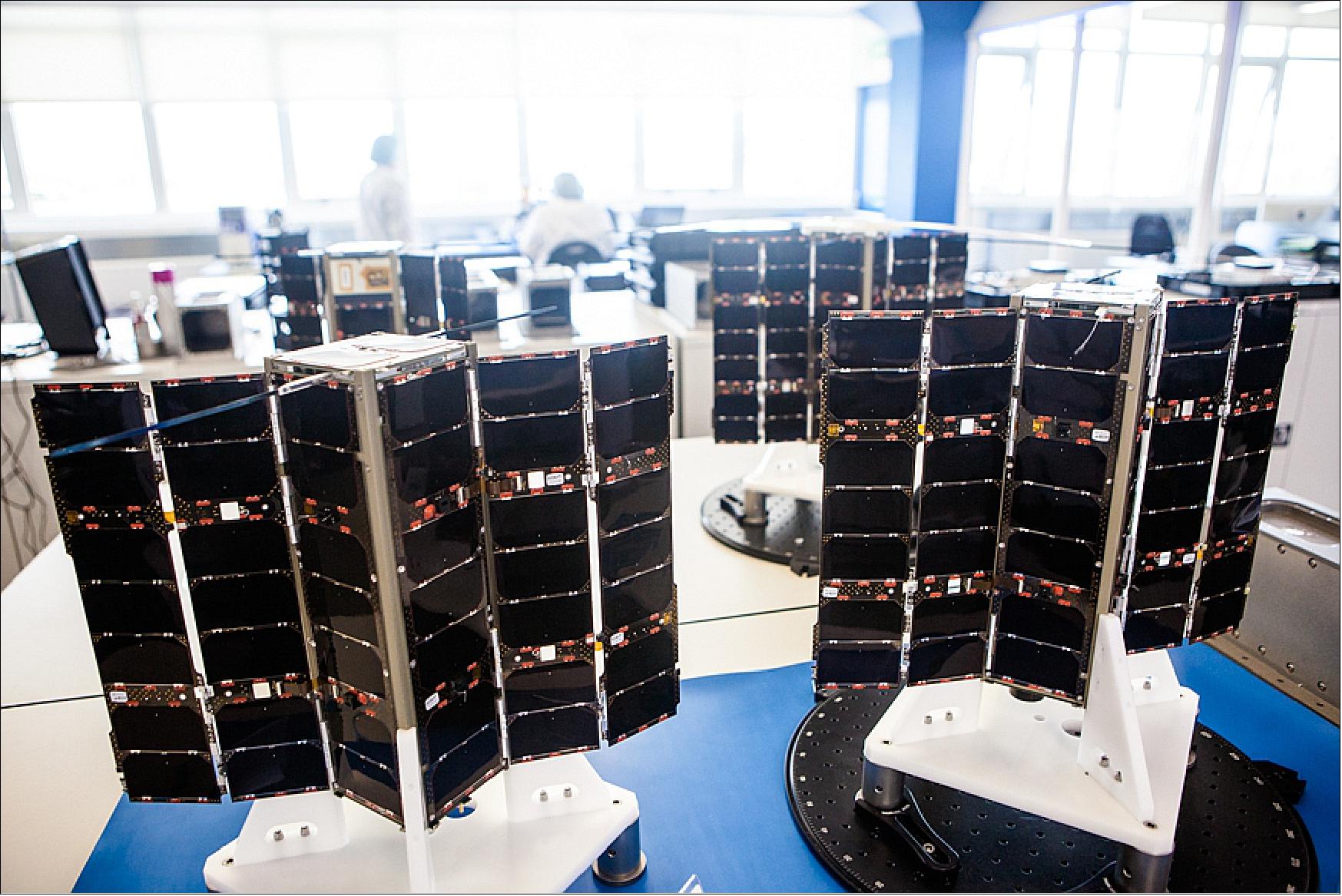
• September 2017: Spire Global’s LEMUR-2 constellation. Spire Global is in the process of deploying a 175-satellite constellation in the 400-600 km altitude range comprised of 3U CubeSats. 6)
Launches
Satellite name | Configuration | Launch date / Deployment date | Launch vehicle/Host spacecraft | Purpose |
Ardusat-1 | 1U CubeSat | Aug. 3, 2013 / Nov. 19, 2013 from | H-IIB/ | Experimentation |
Ardusat-X | 1U CubeSat | |||
Ardusat-2 | 2U CubeSat | Jan. 09, 2014 / Feb. 28, 2014 from | Antares 120 | Experimentation |
Lemur-1 | 3U CubeSat | June 19, 2014 | Dnepr | Prototype |
Lemur-2 #1 Joel | 3U CubeSat (4) | Sept. 28, 2015 | PSLV-XL | Commercial |
Lemur-2 #5 Theresacondor | 3U CubeSat (4) | March 23, 2016 / May 18, 2016 | Atlas V 401 | Commercial |
Lemur-2 #9 Cubecheese | 3U CubeSat (5) | March 23, 2016 / June 22, 2016 | ||
Lemur-2 #14 Sokolsky | 3U CubeSat (4) | Oct. 18, 2016 / Nov. 25, 2016 | Antares 230 | Commercial |
Lemur-2 #18 Trutna | 3U CubeSat (4) | Dec. 9, 2016 / | H-IIB / | Commercial |
Lemur-2 #22 Jobanputra | 3U CubeSat (8) | Feb. 15, 2017 | PSLV-XL-C37 | Commercial |
Lemur-2 #30 Jenny Barna) | 3U CubeSat (4) | April. 18, 2017 / July 2017 | Atlas-5(401) | Commercial |
Lemur-2 #34 ShainaJohl) | 3U CubeSat (8) | June 23, 2017 | PSLV-XL-C38 10) | Commercial |
Lemur-2 #42 Greenberg) | 3U CubeSat (8) | July 14, 2017 | Soyuz-2.1a / Fregat-M 11) | Commercial |
Lemur-2 #50 (YongLin) | 3U CubeSat (8) | November 12, 2017 / Dec. 4, 2017 | Antares 230 Cygnus | Commercial |
Lemur-2 #58 to 67 | 3U CubeSat (10) | November 28, 2017 | Meteor-M N2-1 | Commercial |
Lemur-2 #68 (PW) | 3U CubeSat (4) | January 12, 2018 | PSLV-XL-C40 12) | Commercial |
Lemur-2 #72 (Tallhamn-ATC | 3U CubeSat (2) | January 21, 2018. The Lemur-2 CubeSats | Electron of Rocket Lab | Commercial |
Lemur-2 #74 (Kadi) | 3U CubeSat (4) | February 1, 2018. | Soyuz-2.1a/ Fregat-M vehicle | Commercial |
Lemur-2 #78 (TomHenderson) | 3U CubeSat (4) | May 21, 2018 | Antares 230 Cygnus | Commercial |
Lemur-2 #82 (Zupanski) | 3U CubeSat | November 11, 2018 | Electron Curie | Commercial |
Lemur-2 #84 (Orzulak) | 3U CubeSat | November 29, 2018 | PSLV-CA, from SDSC, India | Commercial |
Lemur-2 #88 (Remy-Colton) | 3U CubeSat | December 27, 2018 15) | Soyuz-2-1a Fregat-M | Commercial |
Lemur-2 #96 (JohanLoran) | 3U CubeSat | April 4, 2019 | EMISAT, Flock 4a-1 | Commercial |
Lemur-2 #100 (Wanli) | 3U CubeSat | July 5, 2019 16) | Meteor-M2-2 (primary | Commercial |
Lemur-2 #108 (Pappy) | 3U CubeSat | December 11, 2019 | Launch on PSLV-QL of ISRO | Commercial |
Lemur-2 #112 (FJMSRBijanka) | 3U CubeSat | September 3, 2020 | Launch on Vega SSMS flight with | Commercial |
Lemur-2 #120 (Susurrus | 3U CubeSats | September 28, 2020 from Plesetsk, Russia | Launch on Soyuz-2.1b/Fregat M | Commercial |
Lemur-2 #124 (v4.7) | 3U CubeSats | October 3, 2020. Flight from NASA's MARS | Launch on CygnusNG-14 with 2 | Commercial |
Lemur-2 #126 (Ozarak) | 3U CubeSats | November 7, 2020 from SDSC (SHAR), India | Launch on a PSLV-DL vehicle | Commercial |
Lemur-2 #130 (Chantal) | 3U CubeSats | January 24, 2021. Flight from on | Launch on SpaceX first | Commercial |
Lemur-2 #138 (Lemur 2161) | 3U CubeSats | April 29, 2021. Flight on Vega mission | Launch with NorSat-3, ELO | Commercial |
Lemur-2 #140 (Jackson) | 3U CubeSats | June 30, 2021. Flight on a Falcon 9 | Launch on SpaceX second | Commercial |
Lemur-2 #146 (Ramonamae) | 6U CubeSats | January 13, 2022. Flight on a Falcon 9 | Launch on SpaceX third | Commercial |
Lemur-2 #148 Rohovithsa | 6U CubeSats | January 13, 2022. Flight on a Falcon 9 | Launch on SpaceX third | Commercial |
Lemur-2 #153 (Karen B) | 3U CubeSats | May 25, 2022. Flight on a Falcon 9 | Launch on SpaceX Rideshare mission Transporter-5 | Commercial |
Lemur-2 #157 | 3U CubeSat | January 3, 2023 | Launch on SpaceX Rideshare mission Transporter-2 | Commercial |
Lemur-2 #164 | #164 - 6U CubeSat | April 14, 2023 | Launch on SpaceX Rideshare mission Transporter-7 | Commercial |
| Lemur-2 #166 (Aadam-Aliyah) Lemur-2 #167 (Embrionovis) Lemur-2 #168 (Naziyah) | 6U CubeSat | June 12, 2023 | Launch on SpaceX Rideshare mission Transporter-8 | Commercial |
| Lemur-2 #169 (Deverill-M-T) Lemur-2 #170 (Mano) | 3U CubeSat | July 18, 2023 | Launch on Rocket Lab Electron KS mission “Baby Come Back” | Commercial |
| Lemur-2 (Mango-2A) Lemur-2 (Mango-2B) Lemur-2 (NanaZ) Lemur-2 (Bass) Lemur-2 (Dilightful) Lemur-2 (Good-Vibes) Lemur-2 (Sanita Vetra) Lemur-2 (Marapamasm) Lemur-2 (The Cleaner) Lemur-2 (JK0903EM1407) Lemur-2 (MJR092620) | 3U CubeSat | November 11, 2023 | Launch on SpaceX Rideshare mission Transporter-9 | Commercial |
| Lemur-2 (Nimbus 2000 Lemur-2 (Valhalla) Lemur-2 (Oba-Ni-Jesu) Lemur-2 (Cael) | 16U CubeSat | January 31, 2024 | Launch on Rocket Lab Electron mission “Four of a Kind” | Commercial |
| Lemur-2 (Charlie Rose) Lemur-2 (Feldhus 59116) Lemur-2 (Johnny Truong) Lemur-2 (Rocinante) | 3U CubeSat | March 4, 2024 | Launch on SpaceX Rideshare mission Transporter-9 | Commercial |
| Lemur-2 (TomatoKechup), Lemur-2 (Lloyd), Lemur-2 (Squirrelcomm), Lemur-2 (Sierrini), Lemur-2 (Ahmed-Asrar), Lemur-2 (191), Lemur-2 (192) | 3U to 16U CubeSats | August 16, 2024 | Launched from Space Launch Complex 4E (SLC-4E) at Vandenberg Space Force Base (VSFB) , onboard SpaceX’s Transporter-11 Rideshare mission, on a Falcon-9 rocket. | Commercial |
Spire Global is a data and analytics company that collects data from space to solve problems on Earth. Owning and operating one of the largest satellite constellations in the world, Spire identifies, tracks, and predicts the movement of the world's resources and weather systems so that businesses and governments can make smart decisions.
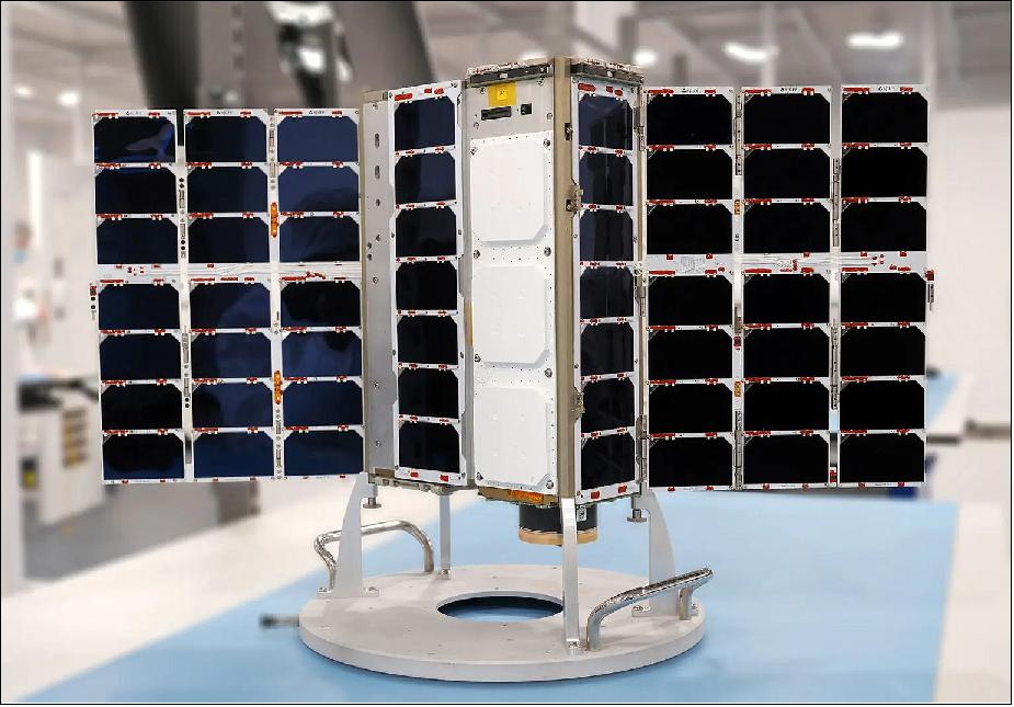
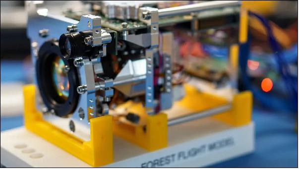
Some Lemur-2 satellites are also built on 6U CubeSat busses to allow for additional hosted payloads to be accommodated. OroraTech 1 is a prototype satellite by Orora Technologies to detect wild fires. It is the precursor mission to a larger constellation of wild fire detection satellites. The OroraTech-1 satellite is based on an enlarged 6U CubeSat version of Spire's Lemur-2 CubeSat and features customized experiments additionally to the standard Lemur payload. It carries OroraTech’s unique and proprietary thermal-infrared camera and data processing unit designed to detect fires and transmit the data using Spire’s satellite and ground network. The technology will help identify and monitor the areas at risk of wildfires and enable early detection of wildfire hotspots.
OroraTech 1 6U Lemur-2 demonstration nanosatellite mission of Spire Global
• January 13, 2022: With the launch of a Falcon 9 rocket, the U.S. space company SpaceX is bringing a payload from OroraTech (Munich, Germany) into space with its Transporter-3 mission. At an altitude of 525 km (±25 km), a satellite about the size of a shoebox (CubeSat) will orbit the Earth and capture continuous high-resolution thermal images of the surface. The data will be analyzed directly in orbit using an AI-based algorithm and then transmitted back to Earth. This significantly reduces fire detection and notification time from hours down to a few minutes, providing invaluable time to avert danger and prevent damage. 19)
- “We capture both mid-wave and thermal infrared radiation with our technology from a great distance,” explains Thomas Gruebler, CEO & co-founder of OroraTech. “We analyze the collected data with our GPU-accelerated onboard processing module in orbit and thus detect characteristic temperature signatures already in space. Our AI-based software ensures that detected wildfires are reported immediately.”
- The Munich-based company entered a long-term partnership with Spire, a Luxembourg-based manufacturer of small satellites, reducing the cost of launching satellites into space and thus creating the capacity to focus more resources on developing the technology. “By consistently developing the technology for small satellites, OroraTech is achieving a fundamental change in the industry cost curve,” said Wolfgang Neubert, partner at APEX Ventures. “With the current demonstration mission, OroraTech wants to prove that the technology is suitable for use in space and that usable images can be taken even at around 500 km. The first data will show what will be possible in the future and pave the way to improved coverage and more accurate predictions.”
- However, forecasting wildfire risk and creating accurate fire spread models require a large number of precise data points. An entire swarm of satellites – a constellation – is necessary to obtain these. In a sun-synchronous orbit, the CubeSat constellation will provide coverage for every point on earth at the same time each day, several times a day. By the end of 2023, a minimum viable constellation (MVC) composed of eight CubeSats will be in operation focusing on capturing thermal images in the late afternoon, the peak fire time for wildfires which is hardly covered by current satellite missions. OroraTech is now closing this gap in the available data and, at the same time, significantly improving the data-cost ratio.
- “OroraTech is addressing a global issue on a large scale,” Florian Erber, Managing Partner & Founder of Ananda Impact Ventures, is pleased to say. “Due to its high scalability, OroraTech is also extremely interesting for investors like us. We believe that the solution portfolio will have a strong economic and social impact but especially in the fight against climate change.” Christian Federspiel of Findus Venture also emphasizes this: “The data has immense value. OroraTech will become even more interesting for investors because of this unique information.”
- The effects of climate change can be seen in the devastating fires experienced in North America and Australia. In August 2021 alone, fires in the northern hemisphere released 1,384.6 megatons of CO2 into the atmosphere – worldwide. OroraTech’s service is of interest to commercial forestry, government agencies, and the insurance industry, as timely warning leads to faster response time and, therefore, less damage. “If you are notified in time that a fire is becoming a danger, you can better protect yourself and your property,” says Grübler. “This is especially relevant for those who can’t get insurance, or can only get it at an incredibly high cost, because of a latent wildfire risk.”
- In the future, OroraTech’s satellites will not only be able to monitor wildfires, but also other processes that contribute to climate change. One such process is gas flaring, the burning of the byproduct from petroleum production, especially in remote areas such as offshore facilities. According to the World Bank, if all gas flaring were stopped today, CO2 emissions could be reduced by 400 million tons per year. The technology from Munich can also be used to determine the evaporation of water in the soil, which is particularly interesting for agriculture and extremely relevant with increased droughts predicted. Even oil spills on water can be monitored more accurately from orbit.
Whatever the challenge may be, OroraTech is poised to take climate change resiliency to a whole new level – from space.
About OroraTech: OroraTech is a NewSpace start-up headquartered in Munich, Germany, providing a global satellite-based wildfire detection and monitoring service by processing data from various available satellite sources. In parallel, the company is developing its own nanosatellite constellation specialized in wildfire detection, with the first satellite launched in early 2022. Founded in 2018 by Thomas Grübler, Björn Stoffers, Florian Mauracher, and Rupert Amann, the company has grown to an international team of over 60 employees. OroraTech is financed by private investors such as Findus Ventures, Ananda Impact Ventures, APEX Ventures, and Bayern Kapital and has been supported by research grants from the Bavarian and German government, the European Space Agency, and the European Commission. To learn more, visit https://ororatech.com.
About APEX Ventures: APEX Ventures is a Europe based Venture Capital Firm investing into deep-tech start-ups with a focus on unique and defendable intellectual property and above-average market potential. APEX funds have completed numerous investments in Europe and in the U.S., among others in the fields of A.I. for medical applications, quantum and laser technologies, automation and robotics, computer vision, space technologies, as well as digital forensics. APEX Ventures closely supports the founding teams in their go-to-market approaches to help accelerate international growth. To identify talented teams and support their ideas at an early stage, APEX Ventures closely works with academic institutions, entrepreneurship programs and other international VC partners. To learn more, visit https://www.apex.ventures.
Spire Lemur-2 Spacecraft
The CubeSats in this investigation are built by Spire, a small satellite communications company dedicated to expanding data collection from space. Spire’s many small satellites provide near-real-time information from anywhere on Earth, enabling more accurate weather forecasts, shipping data and other information. By launching from the ISS, Spire can deploy several small satellites at once, lowering cost and improving access to space. Each Lemur-2 nanosatellite has a mass of ~4.6 kg.
The Lemur-2 satellites carry two payloads: STRATOS GPS radio occultation meteorology payload and the SENSE AIS payload for ship tracking.
Better data on where ships are located benefits consumers and private industry. Improved ocean monitoring enables shipping companies to plan more efficiently; allows insurance companies to understand risks and fault; and assists coast guards in policing territorial waters and preventing piracy and illegal fishing. The satellites in NanoRacks-LEMUR-2 also dramatically increase the amount of raw weather data available for forecasts, improving weather prediction around the globe.
NanoRacks CubeSats are delivered to the ISS already integrated within a NRCSD (NanoRacks CubeSat Deployer). A crew member transfers each NRCSD from the launch vehicle to the JEM/Kibo (Japanese Experiment Module). Visual inspection for damage to each NRCSD is performed. When CubeSat deployment operations begin, the NRCSDs are unpacked, mounted on the JAXA MPEP (Multi-Purpose Experiment Platform) and placed on the JEM/Kibo airlock slide table for transfer outside the ISS. A crew member operates the JRMS (JEM Remote Manipulating System) – to grapple and position for deployment. CubeSats are deployed when JAXA ground controllers command a specific NRCSD. 20)
ISS orbit: Near-circular orbit, altitude of ~400 km, inclination = 51.6º, period ~ 92 minutes.
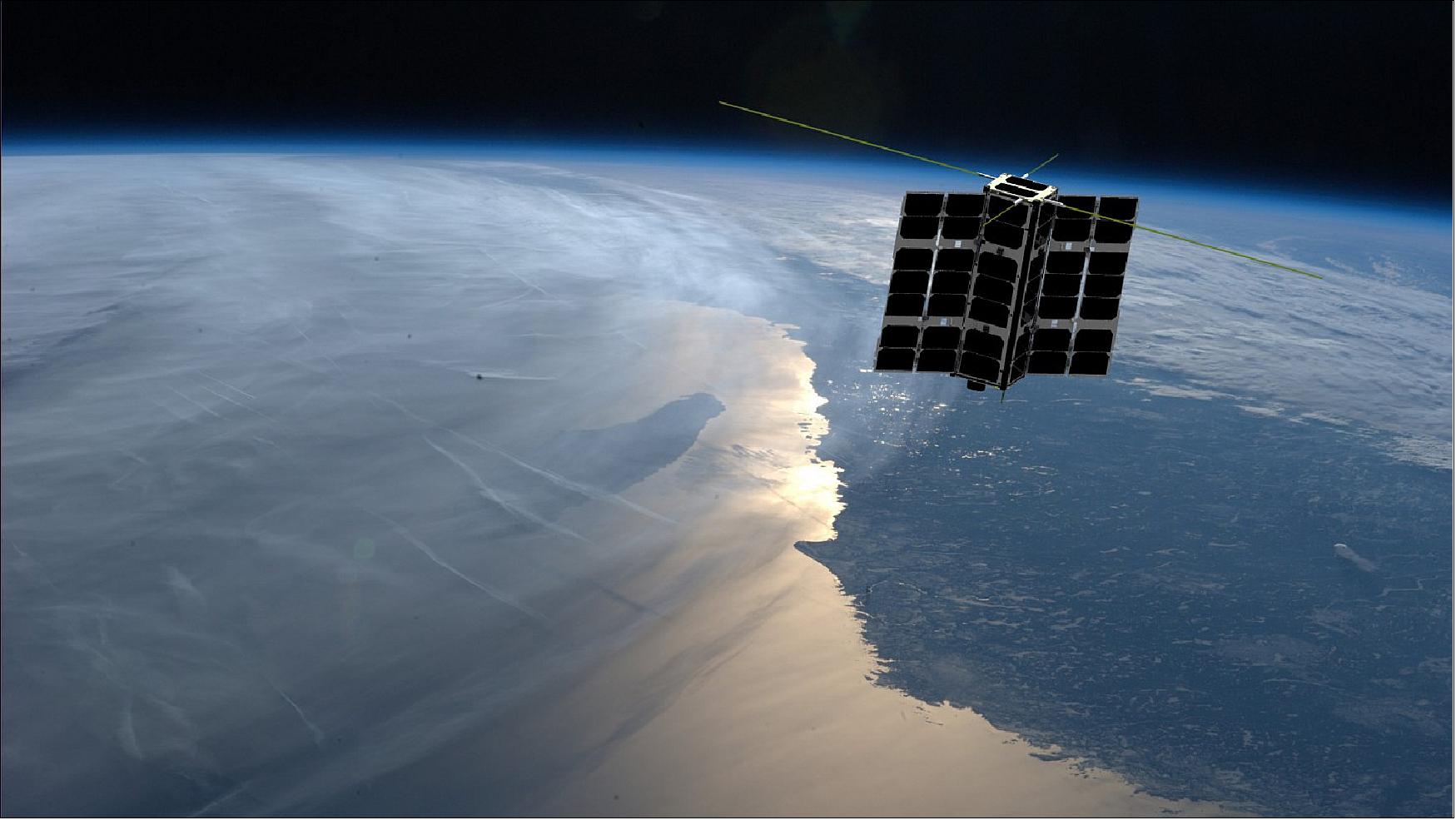
The Spire CubeSats feature 3-axis attitude control/knowledge via Spire ADCS.
RF communications are provided via UHF and S-band.
Mission Status
• August 16, 2024: Spire Global has launched seven new Lemur-2 satellites, ranging from 3U to 16U in size. The launch took place as part of SpaceX’s Transporter-11 Rideshare mission, on a Falcon-9 rocket, from Space Launch Complex 4E (SLC-4E) at Vandenberg Space Force Base (VSFB), in California. 76)
• March 4, 2024: Four Lemur-2 satellites, named Charlie Rose, Feldhus 59116, Johnny Truong and Rocinante, were launched at 2:05 p.m. PT, on a Falcon 9 Transporter-10 SpaceX’s 10th dedicated smallsat rideshare program mission, from Space Launch Complex 4E at Vandenberg Space Force Base in California.
This was the fifth flight for the first stage booster supporting this mission which previously launched Crew-7, CRS-29, PACE, and one Starlink mission. On board this flight were 53 spacecraft, including CubeSats, MicroSats, and a hosted payload. To date, SpaceX has launched nearly 1,000 smallsats for more than 130 customers across our entire Rideshare program. 73) 74)
• January 31, 2024: Four Lemur-2 satellites, named Nimbus 2000, Valhalla, Oba-Ni-Jesu and Cael, were launched into low-Earth orbit from the Māhia Peninsula in New Zealand on Rocket Lab first launch of 2024, named “Four of a Kind”, which lifted off from Rocket Lab’s Launch Complex-1B in Māhia at 7:34 PM NZDT, (06:34 UTC). 74) 75)
• November 11, 2023: At 10:49 a.m. PT, 11 Lemur-2 satellites each with the following nicknames: Bass, Dilightful, Good-Vibes, Sanita Vetra, Marapamasm, The Cleaner, JK0903EM1407, MJR092620, Mango-2A, Mango-2B and NanaZ, were launched on Falcon 9 Transporter-9, SpaceX’s ninth dedicated smallsat rideshare program mission, from Space Launch Complex 4E at Vandenberg Space Force Base in California. This was the 12th launch and landing of this Falcon 9 stage booster, which previously supported the launch of NROL-87, NROL-85, SARah-1, SWOT, Transporter-8, and six Starlink missions.
During this mission, 90 payloads were expected to deploy from Falcon 9 across 89 deployments. 72) 74)
• July 18, 2023: Two Lemur satellites, Lemur-2 (Deverill-M-T) and Lemur-2 (Mano), were successfully launched by Rocket Lab, onboard an Electron KS rocket. The mission was dubbed “Baby Come Back” and lifted off at 01:27 GMT, from Mahia Peninsula, New Zealand. The launch vehicle carried a total of seven satellites into orbit. 70)
• June 12, 2023: Spire has launched three 6U spacecraft onboard SpaceX’s Transporter-8 smallsat rideshare mission via Exolaunch, which was conducted from Vandenberg Space Force Base in California, USA.
One of the satellite is hosting the FOREST-2 thermal imaging payload for OroraTech. The other two Spire LEMUR satellites have AIS/ ADS-B/ GNSS-RO/ RF sensors. 67)
• April 14 2023: Lemur-2 OnReflection and Romeo-n-Leo were launched at 11:48 p.m. PT onboard Falcon 9 for the Transporter-7, SpaceX’s seventh dedicated smallsat rideshare program mission, from Space Launch Complex 4E at Vandenberg Space Force Base in California. 69)
• January 3, 2023: At 9:56 AM EST (14:56 UTC), SpaceX launched Lemur-2 Disclaimer, Emmaculate, FuenteTaja-01, MMolo, PhilAri and SteveAlbers, on the Transporter-6 rideshare mission from Space Launch Complex 40 (SLC-40) at Cape Canaveral Space Force Station (CCSFS).
Falcon 9’s first stage returned to land at Landing Zone-1 at CCSFS approximately eight and a half minutes after launch. 68)
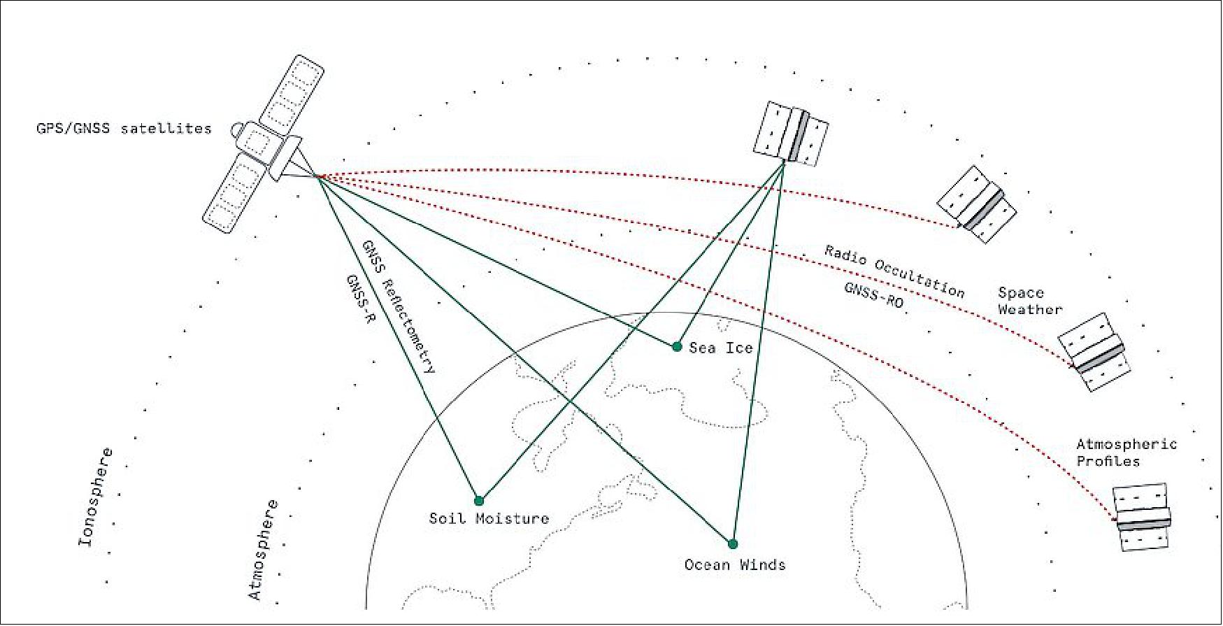
• July 20, 2022: Spire Global, Inc. (NYSE: SPIR) (“Spire” or “the Company”), a leading global provider of space-based data, analytics and space services, today announced plans to build upon its fully deployed constellation of over 100 multipurpose satellites with satellites carrying microwave sounders to gather atmospheric moisture and temperature measurements. The measurements collected by these instruments will expand the company’s data offerings and, when coupled with the weather and Earth intelligence data that Spire currently collects through radio occultation and reflectometry measurements, will further enhance the value and accuracy of its global weather forecasts. 21) 22)
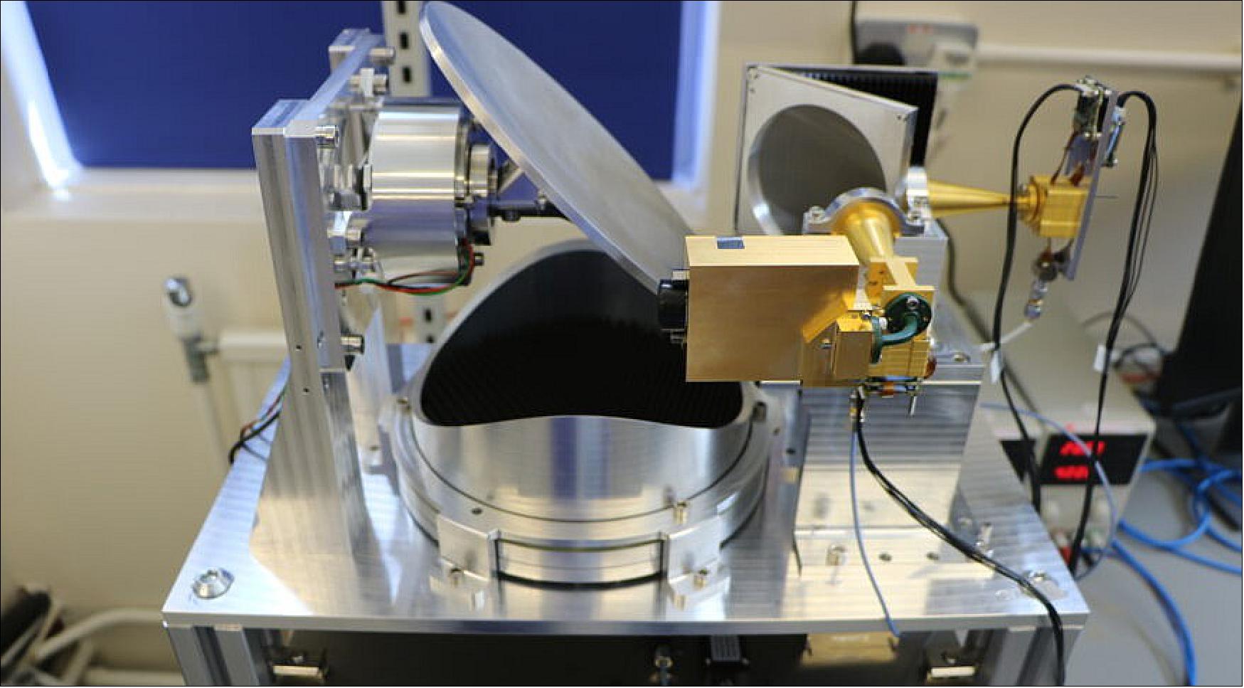
- Spire entered a partnership with RAL Space, a part of the Science and Technology Facilities Council (STFC) in the UK, to further develop and deploy the Hyperspectral Microwave Sounder (HYMS) on Spire satellites. The HYMS instrument is a new, advanced millimeter wave technology that delivers microwave sounding information to improve weather forecasting. Spire and STFC will work together on a demonstrator mission of the HYMS, launching it on a 16U CubeSat of Spire, with the long-term objective of launching a full constellation for atmospheric monitoring.
- “Satellites play a vital role in modern weather forecasting, providing over 90% of data that go into models,” said Kevin Petty, VP, Weather and Earth Intelligence, Spire. “By collecting additional near real-time weather observations, we’re providing meteorological agencies across the globe that use our space-based data with the inputs needed to deliver even more accurate forecasts. We’re also helping commercial organizations increase their operational effectiveness and efficiency in the face of high-impact weather.”
- Satellites are vital for tracking fast-moving extreme weather events and generating critical observations in data-sparse regions, such as in developing countries or over oceans where weather can change quickly.
- Spire and RAL Space’s collaboration demonstrates the power of public and private organizations partnering to bring innovative solutions to market, as well as the UK’s advancement in space and meteorological technologies.
- Business and Energy Secretary Kwasi Kwarteng said: “This project is a major milestone for our National Space Strategy. We are developing the UK’s capabilities as a spacefaring nation and in the process boosting the economy and delivering high-skill jobs. I am delighted the HYMS technology, developed in Oxfordshire, will be put into service by Spire Global. It is further proof of how the UK’s space sector is setting the pace, when it comes to developing products that deliver tangible benefits to businesses and governments.”
- Today, Spire is the largest producer of radio occultation data and offers a vast portfolio of current weather, historical weather data, and weather forecasts solutions. Spire harnesses its constellation of multipurpose satellites and unrivaled radio occultation technology to power highly accurate, targeted forecasts for the world’s key industries. Moreover, Spire’s data is leveraged by government agencies, such as NOAA, NASA and EUMETSAT, to drive global weather predictions and gain additional insights about the Earth system.
- Spire frequently launches satellites with advanced sensors to collect more weather data and continuously improve its forecasts. In addition, Spire’s satellites are software-defined, meaning they can be updated in orbit after they’ve been launched by uploading software, which allows the company to continuously innovate and stay ahead of the curve in meeting customer needs.
• May 25, 2022: Lemur-2 Karen B, Mimi1307, TennysonLily and Van DenDries were launched today at 18:35 UTC (2:35 p.m. EDT), onboard a Falcon 9 rocket carrying the Transporter-5 rideshare mission, SpaceX’s fifth dedicated smallsat rideshare program mission, from Space Launch Complex 40 at Cape Canaveral Space Force Station in Florida. 66)
• May 10, 2022: Spire Global said May 10 it is installing Ku-band antennas from fellow SmallSat operator Kepler Communications on at least three satellites to offer higher capacity data services beginning next year. 23)
- Their deal enables Spire to add high-speed Ku-band capabilities to its fleet in low Earth orbit under Kepler’s existing regulatory licenses, and includes an option to scale up to 50 satellites.
- U.S.-based Spire Global currently provides weather and tracking services with more than 100 satellites in LEO that transmit data in UHF-, S- and X-bands.
- The company also provides a service that offers its technology, ground station network and automated operations systems to others for deploying their own applications and sensors to orbit relatively quickly.
- With a Ku-band software-defined radio from Canada-based Kepler, a Spire Global satellite would be able to send larger amounts of data back to Earth for more data-intensive operations.
- Spire head of communications Hillary Yaffe said the Ku-band payload will benefit customers that include Canadian startup NorthStar Earth & Space, which March 16 said Spire will deliver and operate satellites focused on space situational awareness and debris monitoring.
- Spire’s deal with NorthStar is for an initial three 12-unit CubeSats for launch in 2023, with an option to expand to a full constellation of dozens of satellites.
Service Expansion
- Kepler said its 19 satellites each have a variant of the Ku-band payload for a constellation that generates most of its revenues from providing connectivity to devices beyond the reach of terrestrial networks.
- The Canadian company has been seeking to expand into new markets after raising $60 million in June, including plans for data-relay services with an S-band terminal that successfully tested inter-satellite links earlier this year.
- In a separate deal announced Dec. 16, Kepler said it plans to test its data relay terminal on a Spire nanosatellite slated to launch late in 2022.
- Flown as a hosted payload, Kepler’s new Ku-band service includes the ground infrastructure needed to provide an end-to-end data transmission service.
- Mina Mitry, Kepler’s CEO, said undisclosed customers are already using the Ku-band terminals on its satellites to “transmit large quantities of data point-to-point across the globe quickly.”
- These customers are using a new service Kepler calls Global Data Services (GDS), he said, which is designed to be compatible with third-party fixed, maritime and next-generation flat panel antennas.
- According to Kepler, GDS has achieved more than 300 megabits per second (Mbit/s) of data speeds from LEO to a 3.4-meter dish on the ground with its Ku-band technology — and 240 Mbit/s on a Kymeta flat panel antenna.
- “GDS has helped our customers move data and given us valuable flight heritage for our next generation Ku-Band service – testing and validating the technology on the 19 satellites on-orbit,” Mitry said via email.
- He declined to disclose a dollar value for its Ku-band antenna contract with Spire, which went public in August by merging with a special purpose acquisition company (SPAC).
- The first Spire satellites with Ku-band service are slated to launch in early 2023.
- While the standard version of Kepler’s Ku-band software-defined radio is designed for satellites in LEO, Mitry said its in-house manufacturing capabilities enable the company to adapt the technology for other orbits and customer needs.
• May 5, 2022: Spire Global, Inc. (“the Company” or “Spire”), a leading global provider of space-based data, analytics and space services, today announced a new contract with Gale Force, a global weather routing and performance monitoring service, to provide weather data to enhance its maritime route optimization platform. 24)
- With Spire’s global weather data, Gale Force can provide its maritime customers with optimal route recommendations, helping them save time, reduce fuel costs and increase the accuracy of arrival times at ports. It also reduces carbon emissions, which is a major step towards creating sustainable practices in the shipping industry.
- Spire has the ultimate vantage point from space to collect global weather data through its constellation of over 100 satellites, reaching remote areas like the open oceans that have traditionally been difficult to gain insight into. With these unique weather observations and using cutting-edge machine learning techniques to enhance the data, Spire provides a reliable and accurate global weather forecast. This is especially important in the maritime industry where ships may be confronted midway through their journeys with hazardous weather conditions that pose a threat to crew safety and can significantly delay their arrival.
- “If you work in shipping, you know that weather is of the utmost importance as it can make or break your journey,” said Tom Sandberg, Gale Force CEO. “Spire’s data and analytics give us insights into weather patterns in the far reaches of the ocean to ensure our customers have the best route to get to their end destinations faster, safer and in a more fuel-efficient manner.”
- “We’re proud to share Gale Force’s mission of advancing the maritime sector and building a safer and more sustainable world,” said Durjoy Mazumdar, Global Head of Weather Sales, Spire. “Data is a powerful tool to create a more efficient global trade network that can help secure the supply chain while reducing the environmental footprint of maritime activity.”
- About Spire Global: Spire (NYSE: SPIR) is a leading global provider of space-based data, analytics, and space services, offering access to unique datasets and powerful insights about Earth from the ultimate vantage point so that organizations can make decisions with confidence, accuracy, and speed. Spire uses one of the world’s largest multi-purpose satellite constellations to source hard to acquire, valuable data and enriches it with predictive solutions. Spire then provides this data as a subscription to organizations around the world so they can improve business operations, decrease their environmental footprint, deploy resources for growth and competitive advantage, and mitigate risk. Spire gives commercial and government organizations the competitive advantage they seek to innovate and solve some of the world’s toughest problems with insights from space. Spire has offices in San Francisco, Boulder, Washington DC, Cambridge, Ontario, Glasgow, Oxfordshire, Luxembourg, and Singapore. To learn more, visit www.spire.com.
- About Gale Force: The Gale Force mission is to offer world-class global weather routing and performance monitoring services, delivered through a state-of-the-art industry platform and supported by personalized advisory services. Gale Force’s team has more than 30 years of experience collectively in international shipping, marine meteorology, naval architecture, and technological development. The company is headquartered in Norrköping, Sweden. To learn more, visit www.galeforcesweden.com.
• April 27, 2022: Spire Global, Inc. (“the Company” or “Spire”), a leading global provider of space-based data, analytics and space services, today announced the addition of Weather Insights and Weather by Route solutions to its portfolio. These solutions provide customers with an analysis of how upcoming weather conditions will impact their operations and enable them to focus on improving efficiency and safety. 25)
- Spire collects global weather data through its fully-deployed constellation of over 100 satellites, reaching remote areas like the open oceans that have traditionally been difficult to observe. This is especially important in the maritime industry where a vessel can be impacted by unexpected extreme weather midway through its journey causing it to take a less efficient route and increase its speed, which results in higher fuel emissions.
- By combining weather data with maritime expertise through artificial intelligence and machine learning, Spire Weather Insights saves customers development time and costs. Spire’s customers no longer need to allocate resources to data collection and mining, nor acquire other data sources to garner the necessary insights that drive decision making. Organizations can simply integrate Spire’s API into their application, allowing them to focus on the core competency of their business.
- Spire’s new weather solutions empower vessel operators with data and actionable recommendations for their voyages:
a) Risk Insight provides weather risk level for vessel, cargo, and crew at each leg of a voyage at sea. The user inputs characteristics of the vessel, load, and desired route into an API, and Spire’s proprietary algorithm calculates the projected risk along the route.
b) Efficiency Insight anticipates the impact of weather along each leg of a route allowing vessel operators to chart optimized routes, both before and during a voyage, to reduce fuel consumption.
c) Weather by Route delivers highly customized and accurate weather forecasts along a vessel’s planned path on the open ocean. It helps vessel operators plan a route or monitor a voyage in motion.
- “As a mission-driven company, we’re committed to providing solutions for today’s global challenges, such as global supply chain disruptions and climate change,” said Dr. Kevin Petty, VP, Weather and Earth Intelligence at Spire. “Our weather solutions give maritime organizations the resources they need to optimize fuel consumption, reduce their carbon footprint, better predict port ETA, and keep crew safe from hazardous weather conditions.”
- To learn more about Spire’s weather solutions, visit spire.com/weather.
• April 12, 2022: Spire Global announced today it has successfully completed its previously announced acquisition of exactEarth Ltd. (TSX: XCT) (“exactEarth“), a leading provider of global maritime vessel data for ship tracking and maritime situational awareness solutions, by way of a plan of arrangement, following the completion of all closing conditions. 26)
- Under the terms of the transaction, Spire acquired all of the outstanding common shares of exactEarth (the “Shares“) through its wholly-owned indirect subsidiary Spire Global Canada Acquisition Corp. (the “Purchaser“) for CAD$2.5009 (approximately US$1.9592, based on the Bank of Canada’s CAD/USD exchange rate of 0.7834 on November 29, 2021) in cash and 0.1 share of Spire Class A common stock for each Share held. With the completion of the acquisition, exactEarth common shares will be de-listed from the Toronto Stock Exchange as of the close of trading on or about December 2, 2021.
- “We are excited to welcome the exactEarth team to the Spire family. Together, we will continue to drive the digitalization of the maritime industry through providing our customers with innovative, actionable data solutions that have meaningful impact on businesses, society, and the planet,” said Peter Platzer, Spire’s Chief Executive Officer.
- Now that the acquisition is complete, Spire will work with the exactEarth team to ensure a seamless experience for exactEarth’s 150+ customers, representing approximately $18 million in ARR. During Spire’s Q3 2021 earnings call, the Company gave guidance for its 2021 year-end of $48.6 million to $52.0 million in ARR and a range of 225 to 242 ARR solution customers. This guidance did not factor in the transaction. Over the coming months, the two teams will also be focusing on fostering a smooth transition for exactEarth’s experienced sales and product development team as well as the rapid integration of exactEarth’s historical database to accelerate artificial intelligence- and machine learning- driven product development.
- exactEarth is now a fully-owned subsidiary of Spire and will continue to operate from Cambridge, Ontario, Canada under the leadership of Mr. Mabson, reporting directly to Mr. Platzer. As such, exactEarth will submit an application to cease to be a reporting issuer under applicable Canadian securities laws and to otherwise terminate exactEarth’s public reporting requirements.
• February 11, 2022: Spire Global today announced that it has been awarded as part of Indefinite Delivery Indefinite Quantity (IDIQ) Delivery Order 4 of the contract issued by the National Oceanographic and Oceanic Administration (NOAA), for commercially available space-based radio occultation (RO) data for use in operational weather forecasts. The award, valued at over $8 million, represents the single largest U.S. government purchase of commercial, operational RO data. 27)
- The award is the next milestone in NOAA's goal to expand the purchase of commercial RO data. It is an increase in the number of RO profiles that Spire provides NOAA from 3,000 to 5,500, serving as a testament to Spire's proven ability to reliably deliver valuable, operational RO data, profiling atmospheric temperatures and related quantities for weather models helping NOAA and as a result American citizens prepare for extreme weather events.
- In addition to the forecast accuracy benefits, NOAA recently announced commercially sourced data was about one-quarter to one-half the cost of government-sponsored missions, further demonstrating the long-term viability of partnering with Spire. Spire’s constellation of more than 100 satellites collects more RO profiles than any other organization across the globe.
- “With a continual increase in extreme weather patterns, the U.S. has taken the important step to protect its citizens by continually investing and upgrading its weather forecast capabilities,” said Kamal Arafeh, Senior Vice President of Sales, Spire. “This award is the culmination of years of our team's hard work to develop, manufacture and operate a constellation of satellites that leverage the powerful vantage point of space to improve life on Earth. We are honored to further our partnership with NOAA on their important work in addressing one of humanity’s greatest challenges amid climate change - accurate weather forecasting.”
- Spire's data provided to NOAA will be made available in near-real-time to national and international meteorological organizations and the broader U.S. federal government upon receipt, enabling increased information sharing for critical weather data. The data delivery will commence on March 16, 2022 and run until January 18, 2023.
• January 13, 2022: Lemur-2 Rohovithsa, Miriwari and Djirang were launched today at 10:25 a.m. EST onboard Falcon 9 for the Transporter-3, SpaceX’s third dedicated SmallSat Rideshare Program mission, from Space Launch Complex 40 at Cape Canaveral Space Force Station in Florida. 65)
• October 5, 2021: LatConnect 60 will feed Spire Global Automatic Identification System (AIS) vessel-tracking data into algorithms the Australian Earth-observation startup is developing with Curtin University to prevent maritime collisions, the companies announced Oct. 5. 37)
- With funding from the Australian Research Council, LatConnect 60 and Curtin University’s Intelligent Sensing & Perception Laboratory are creating sensor-fusion algorithms to better predict maritime traffic patterns. If successful, the algorithms could reduce collisions in narrow shipping lanes and lower insurance premiums for vessel operators, according to the Oct. 5 news release.
- The new sensor-fusion algorithms pair Spire AIS data with satellite imagery, drone imagery and data from internet-of-things sensors.

- “Spire’s advanced AIS data has provided significant value to us and we’re thrilled to build on our partnership to enhance our capabilities,” LatConnect 60 CEO Venkat Pillay said in a statement. “Incorporating Spire’s proprietary data into our research work with Curtin University will allow unprecedented insight into the real-time location of vessels, helping avoid collisions and create a safer and more profitable maritime industry.”
- LatConnect 60 plans to launch its first two satellites to gather one-meter-resolution Earth imagery in seven spectral bands in 2022. The Australian startup plans to operate a 16-satellite constellation by 2025.
• September 28, 2021: Spire Global is working with SpaceChain, a company focused on space applications for blockchain technology, to demonstrate the technology in orbit. 28)
- Under the partnership announced Sept. 28, Spire will upload SpaceChain software onto a satellite in Spire’s existing constellation. Later this year, Spire plans to launch a SpaceChain payload on a new satellite.
- “Space is the next frontier for businesses, and through Spire’s satellite infrastructure we are taking global collaboration to the ultimate vantage point,” Zee Zheng, SpaceChain co-founder and CEO, said in a statement. “This partnership will help us leverage satellite-based computing to remove barriers and create a more open, collaborative and global economy.”

- To provide enough compute power for the blockchain demonstration, Spire will rely on Sabertooth, the firm’s parallel processing unit initially designed for machine-learning applications.
- “We’re delighted to work alongside SpaceChain and demonstrate innovative ways to leverage outer space,” Theresa Condor, Spire Space Services executive vice president and general manager, said in a statement. “Space-based computation is already proving its value across countless industries and use cases, and we’re excited to help realize its potential for emerging and decentralized blockchains.”
- While blockchain gained prominence as a cryptocurrency tool, organizations also are exploring its benefits for supply chain management, cybersecurity and other tasks.
- Through their partnership, Spire and SpaceChain “aim to maximize data security and increase the resiliency of computing operations,” according to a Sept. 28 news release.
- Blockchain distributes keys across many nodes in a network. The wide distribution is designed in part to ensure there is no single point where someone could tamper with the network or steal data.
- SpaceChain is working with Addvalue Innovation and Alba Orbital to design a decentralized satellite infrastructure, under a 440,000 pound ($596,000) grant awarded in 2020 by Enterprise Singapore and Innovate UK. Working together, the companies are designing a blockchain payload that would enable people or organizations to task a satellite directly to perform a job like capturing imagery of a specific location.
• September 24, 2021: Members of the House Science Committee asked the new administrator of the National Oceanic and Atmospheric Administration (NOAA) to make more use of commercial satellite data and take action on space traffic management. 29)
- At a Sept. 23 hearing of the committee’s environment subcommittee, Rep. Frank Lucas (R-Okla.), ranking member of the full committee, questioned NOAA Administrator Richard Spinrad about the agency’s use of commercially acquired data from satellites to aid in weather forecasting (see Figure 5).
- Lucas said he was “thrilled” that NOAA made another purchase of commercial weather data in August, acquiring 3,000 radio occultation profiles a day for six months from Spire. “But I’m concerned we could be leaving valuable data on the table,” he said, because companies that did not have satellites in orbit when the program started can’t compete until a new round of proposals is requested in about a year.
- Spinrad, confirmed to the post in June, responded that while he supported commercial weather data in general, there was a “cautionary note” about its application for weather forecasting. “We need to make sure that it meets the standards that are applied, and also that it’s sustainable,” he said. “In the worst-case scenario, we end up developing products and services that are critically dependent on the provision of commercial data, and then for a variety of economic or business reasons those data are not available.”
- He said it will take “a little bit of time” for NOAA to assess “the data quality, the data accuracy and the sustained availability of those data” for weather forecasting, efforts he argued were consistent with the legislation that established the commercial weather data program at NOAA.
- The adoption of commercial weather data by NOAA has been a slow process, but agency officials said they expect such data to be increasingly used in weather forecasting. “It took a lot of back-and-forth dialogue over a couple of years, but we now have an operational commercial data purchase program to provide the radio occultation data to NOAA, and we expect that to be an essential part of our information content for the future,” said Stephen Volz, acting assistant secretary for environmental observation and prediction at NOAA, during a panel at the Satellite 2021 conference Sept. 10.
- That data is, for now, limited to GPS and other satellite navigation signal radio occultations, which provide profiles of the atmosphere. Volz said NOAA is continuing to consider other data it can purchase commercially, such as microwave sounding data. However, like Spinrad, he said that NOAA has to keep the availability of data into account.
- We have to balance the availability of new data against the reliability and long-term sustainability of that data source so that our customers are not shocked by upgrades or downgrades in performance based on the availability of a particular data set,” he said.
- At the hearing, Lucas raised similar questions about the purchase of commercial space weather data. The Promoting Research and Observations of Space Weather to Improve the Forecasting of Tomorrow (PROSWIFT) Act, enacted in October 2020, directed NOAA to establish a pilot program for purchasing space weather data within 12 months of its enactment. However, he noted NOAA issued a request for information before the bill’s passage but found no companies that meet its mission needs.
- “While NOAA may have been proactive, I don’t believe their updated responsibilities for space weather related research forecasting capacity were perhaps fully considered in the RFI,” he said, asking Spinrad to issue an updated RFI or request for proposals.
- Spinrad said he would take the issue for the record. “But you have my commitment to look into that and see what the appropriate next step would be.”
Space Traffic Management Concerns
- Later in the hearing, Rep. Brian Babin (R-Texas), ranking member of the space subcommittee, asked about the Office of Space Commerce, which is housed within NOAA, and its work on space traffic management. He expressed concern the office was using funding appropriated for fiscal year 2021 to develop a space situational awareness open architecture data repository for other studies instead.
- Spinrad said he has “embraced” the issue of space traffic management since taking over NOAA. “We are taking very specific actions,” he argued, including work on the data repository. An interagency demonstration of that data repository is planned for the “next several weeks,” after which NOAA will demonstrate it to Congress.
- NOAA is also looking at alternatives for the organization of the office, including merging it with NOAA’s Commercial Remote Sensing Regulatory Affairs office. “It requires careful consideration of the operational responsibilities and regulatory responsibilities,” he said. “We’re looking at alternatives, and we’ll have that analysis of alternatives ready very shortly.”
- He also questioned whether the office had all the authorities needed to take on civil space traffic management. “We are looking at that as well.”
- Later the same day, NASA’s Aerospace Safety Advisory Panel made another call for Congress to act on space traffic management. Patricia Sanders, chair of the panel, cited SpaceX’s proposal for an additional 30,000 Starlink satellites as evidence of the urgency of the issue.
- “It does underscore our persistent concern with the lack of a formally designated and resourced lead agency for space traffic management,” she said. “This continues to be a critical safety concern, a growing safety concern, that remains unaddressed by the Congress, and it’s well overdue to be acted on.”
• September 14, 2021: Newly listed small satellite constellation operator Spire Global is buying Canadian ship-tracking company exactEarth in its first major acquisition, inflating expectations of more space consolidation amid a surge of companies going public. 30)
- Vienna, Virginia-based Spire, which provides data-gathering and analysis services in maritime and other markets with more than 110 Lemur satellites in low Earth orbit, is acquiring exactEarth for about $161.2 million through a mix of cash and stock.
- The deal values exactEarth at just over nine times its total revenue over the last 12 months, the companies said in a Sept. 14 announcement.

- Shareholders in exactEarth will own about 3.8% of Spire after the transaction, if at least two-thirds of them approve it during a meeting they expect to hold in November.
- Spire has already got the support of around 60% of exactEarth’s shareholders, including its directors and officers.
- Peter Mabson, exactEarth’s chief executive officer, will report to Spire CEO Peter Platzer under the plan, as exactEarth becomes a fully owned subsidiary of Spire.
- “Peter and I share a vision about the opportunity for space-based maritime data and the digitalization of the global maritime industry, and I look forward to pursuing that vision together,” Platzer said in a statement.
- “I have great respect for the highly experienced team at exactEarth and am excited to continue driving this digital transformation together, serving more customers with a more robust data and solutions platform.”
- Cambridge, Ontario-based exactEarth was founded in 2009 to provide Satellite-Automatic Identification System (S-AIS) services to the global maritime industry.
- Spire said the acquisition increases its customer base by more than 75%, adding over 150 S-AIS commercial and government customers across 39 countries.
- Last year, exactEarth sold four of its satellites and associated ground stations and equipment to Australian startup Myriota, which uses them as part of a network for connecting IoT (Internet of Things) devices.
- The Canadian operator currently has 63 satellites in orbit and seven spares.
- Spire said buying exactEarth gives it an indirect ownership stake in Myriota, providing another avenue for expansion in the fast-growing satellite-based IoT market.
- Spire started trading on the New York Stock Exchange Aug. 17 after merging with NavSight, a special purpose acquisition company (SPAC).
- The merger raised $265 million in cash for investing in sales, marketing and product development operations to expand globally.
- SPACs, or blank check firms that offer companies a relatively speedy route to the public markets, are a growing trend among space startups.
- Chris Kemp, CEO of small launch vehicle developer Astra that went public July 1 after a SPAC merger, expects a wave of acquisitions will soon join the trend.
- Speaking at a Sept. 9 panel during the Satellite 2021 conference, Kemp said a round of consolidation could have decade-long implications for the satellite industry.
- Peter Beck, CEO of recently listed Rocket Lab, told the conference that his company is considering several potential deals.
SPAC Symptoms
- Space companies marketing SPAC mergers to investors often point to a sizable increase in future revenues, and adding another company’s sales to the mix is one route to achieve this.
- Payam Banazadeh, CEO and founder of synthetic aperture radar (SAR) satellite imagery startup Capella Space, said this is partly why space companies with SPAC mergers are generally looking for additional sources of revenue beyond their core products.
- Speaking to SpaceNews about the space SPAC market in general, Banazadeh said: “You add more products .... that somehow gets to more revenue, right?”
- He said Capella is continuing to watch the SPAC activity in the industry from the sidelines.
- “There aren’t that many companies out there that have real assets in space, products, generating revenue, delivering things — and so we feel like we have a lot of options,” he added.
- “Unfortunately, some of the companies that SPAC’d didn’t have options and that’s why they SPAC’d.
- “And so it’ll be really interesting to see what happens to them, especially with this new market.”
- Spire has a strategic partnership with ICEYE, a Finland-based provider of SAR imaging satellites.
• September 1, 2021: Spire, a leading provider of space-based data, analytics and space services, today announced it has been awarded the next order to provide commercial radio occultation (RO) weather data for the National Oceanographic and Oceanic Administration’s (NOAA) operational Numerical Weather Prediction (NWP) models. The order represents the largest volume of commercial weather data purchased to date by NOAA under the Commercial Weather Data Buy Program. 31)
- This purchase comes as NOAA has stated its intention to purchase increasing volumes of commercial RO data. The data provided by Spire will increase the volume of RO data available for assimilation into the national weather prediction models, improving the accuracy of those models and decreasing uncertainty in weather forecasting.
- “As we see the effects of global warming impacting our weather patterns and events across the globe daily, the U.S. has a duty to its citizens to increase its weather forecasting capabilities to ensure the protection of millions of lives from extreme weather events,” said Peter Platzer, CEO of Spire. “By providing data and analytics to NOAA’s weather prediction models, we know we can strengthen those models, ultimately saving lives and millions of dollars. This award furthers Spire’s partnership with NOAA to provide the highest quality RO data at the highest volume and most cost-efficient investment for taxpayers.”
- NOAA will be purchasing Level 0 and Level 1 RO profiles from Spire. The order, which runs for six months, will provide 3,000 radio occultation profiles per day, out of Spire’s constellation’s capacity of more than 10,000 profiles per day. Spire’s expansive radio occultation capability enables the Company to simultaneously deliver data to both NOAA and the European Organisation for the Exploitation of Meteorological Satellites (EUMETSAT).
- In addition, the data provided to NOAA by Spire will be made available to international meteorological organizations and the broader U.S. federal government upon receipt, enabling increased information sharing for critical weather data.
• August 24, 2021: Spire Global Inc. and Mantle Labs, a pioneering, satellite-based remote-sensing company, jointly announced a new strategic partnership to provide complete risk assessment solutions to banks, crop input, insurance, and agri-commodity companies for managing their agriculture portfolios. This partnership will also help farmers by providing them advance warnings on crop health, weather, and pest and disease activity to help them prevent losses. Powered by Spire’s space-based data and Mantle Labs’ AI-driven agriculture risk analytics suite, this partnership provides a clearer world view of global agriculture in previously unobserved regions. 32)
- Informed by Spire’s advanced data insights, Mantle Labs will have access to critical weather data in South East Asia, India, South America, and Africa, all of which currently lack adequate weather infrastructure. Radio occultation data collected by Spire’s satellites and analyzed by its advanced weather algorithm will complement crop health data by Mantle Labs. The partnership will unlock a comprehensive and reliable weather forecast to empower the agriculture industry.
- John Lusk, Vice President, General Manager Global Data Services (GDS) at Spire, said: “We are proud to be partnering with Mantle Labs to help farmers, banks, crop input, insurance, and agri-commodity companies access previously difficult weather data in under-observed areas around the world in one of our most complementary partnerships to date. It is critical that technology reach these locations to empower farmers on the ground, maximize their profit, and properly anticipate risk assessment, especially in the face of rapidly accelerating climate change.”
- Swapnil Baokar, Co-Founder of Mantle Labs, said: “We operate in many countries where there is a lack of reliable weather monitoring. This leads to issues for industries like agriculture where weather data and forecasting are vital for risk mitigation. Our cutting-edge Geobotanics platform, powered by AI, is used by leading customers in food and agriculture. Adding Spire’s revolutionary technology will offer unprecedented access to high quality weather forecasts at global scale and offer greater visibility into weather-related risks, helping the world’s farmers build climate resilience.”
- Spire’s constellation of more than 100 low-orbit nanosatellites collect real-time data from every layer of the atmosphere, including notoriously difficult high altitudes. Spire’s team works to add new hardware, improve forecast API, and customize predictive weather models to power their customers’ most ambitious projects.
• August 16, 2021: Spire Global Inc. a leading global provider of space-based data, analytics and space services, today announced it has completed its previously announced business combination with NavSight Holdings, Inc. (NYSE: NSH) (“NavSight”) to take Spire public. The combined company has been renamed “Spire Global, Inc.” and its shares will commence trading on the New York Stock Exchange on August 17, 2021, under the ticker symbol “SPIR” for Spire common stock and “SPIRW” for Spire warrants. 33)
- Upon closing, the combined company received approximately $265 million in gross proceeds, comprised of approximately $20 million in cash held in trust by NavSight and the proceeds of a $245 million PIPE. NavSight’s shareholders approved the transaction at a shareholder meeting on August 13, 2021.
- “We are excited to embark on our next chapter as a public company, and to continue to inspire, lead, and develop the business of space-based data,” said CEO Peter Platzer. “Building upon our fully deployed, proprietary satellite constellation and global infrastructure, we are focused on strengthening our ability to provide our customers with more data, faster, so that they can make better informed decisions about their missions and businesses, as well as some of the most pressing issues facing humanity today, including climate change mitigation and adaptation.”
- As a public company, Spire’s position as a leading space-powered data, analytics, and space services company, with one of the world’s largest constellation of multi-purpose satellites in low earth orbit (LEO), is further strengthened. CEO and Co-Founder Peter Platzer, along with the rest of the Spire management team will continue to lead the company’s operations. As part of the business combination, Jack Pearlstein, Chief Financial Officer of NavSight, will join Spire’s board of directors.
- “Jack and I are excited to support Peter and his team as Spire continues to execute on its strategic growth plan as a public company,” said Bob Coleman, Chairman and Chief Executive Officer of NavSight.
• August 6, 2021: Europe’s meteorological satellite agency is buying commercial data for the first time, raising hopes that it will open up more agency and government contracts to the private sector. 38)
- EUMETSAT, an intergovernmental group backed by 30 European member states, announced a pilot Aug. 5 to buy weather forecasting data from Luxembourg-based Spire Global.
- It agreed to spend as much as nine million euros ($11 million) over three years to buy the radio occultation data that Spire collects, giving EUMETSAT more information on the atmosphere’s temperature and moisture levels to make weather forecasting models more accurate.
- The data from Spire, which operates more than 100 nanosatellites in low Earth orbit and plans to start trading on the New York Stock Exchange this summer, will feed into data EUMETSAT gets from other sources.
- “EUMETSAT already supplies radio occultation data from an instrument on board its MetOp low-Earth-orbiting satellites to the meteorological services in its Member States but research has shown that the use of more of these data increases the accuracy of weather forecasting models,” EUMETSAT Director General Phil Evans said in a statement.
- Evans, who became director general in January, said the pilot allows the group to “assess the costs versus the benefits of opportunities that are available from” space startups.

- The agreement gives EUMETSAT a global license for accessing Spire’s data in near real-time. It also allows the agency to share the data immediately with third parties.
- Luis Gomes, CEO of Swedish satellite maker and space solutions provider ÅAC Clyde Space, said the agreement is “great news” for space startups.
- “Commercial companies can be a powerful ally in dramatically expanding weather data collection by bringing more timely data and whole new types of data to the market,” Gomes said.
- ÅAC Clyde Space recently acquired Omnisys, which develops weather sensors and instruments for space.
- “For companies like ÅAC Clyde Space, that are developing advanced weather data missions, this marks a crucial milestone in European weather data policy,” Gomes added.
- “This is the start of a revolution in the way we access space weather data, and I am sure this will transform the way we forecast and monitor weather. It is an area of development that is increasingly important as our climate rapidly changes.”
• July 29, 2021: Spire Global, a leading global provider of space-based data, analytics and space services, today announced its preliminary financial results for the six months ended June 30, 2021 and provided updated guidance for the year ending December 31, 2021. On July 26, 2021, Spire also announced that the registration statement on Form S-4 (File No. 333-256112) of NavSight Holdings, Inc. (“NavSight”), relating to the previously announced merger of NavSight and Spire (the “Business Combination”) was declared effective by the U.S. Securities and Exchange Commission as of July 22, 2021, and that the special meeting of stockholders (the “Special Meeting”) to approve the Business Combination would be held on August 13, 2021 at 10:00 AM ET. 39)
- "We believe that the need for space-based Earth data to solve the greatest challenges facing businesses, governments and humanity is growing every day. We feel privileged to partner with some of the leading organizations and agencies around the world to execute on their missions, solve problems and address these issues," said Peter Platzer, Chief Executive Officer of Spire. "We are encouraged by our customer and pipeline growth as well as other market and industry activity, particularly due to our strengthened market position once we become a public company."
• July 14, 2021: Satellite data provider Spire Global received a six-million-dollar, 12-month contract extension from NASA to continue its participation in the agency’s Commercial Smallsat Data Acquisition (CSDA) program. Under the extension, Spire will deliver a comprehensive catalog of data, associated metadata, and ancillary information from its Earth-orbiting small-satellite constellation. These data will be available for scientific purposes at no cost to all U.S. federal agencies, NASA-funded researchers, and, more broadly, all U.S. government-funded researchers. They will be archived and maintained by NASA as part of CSDA’s Smallsat Data Explorer (SDX) tool. 40)
- Specific data products in the subscription data-buy with Spire include radio occultation (RO), grazing angle Global Navigation Satellite System-RO (GNSS-RO), total electron content (TEC), precise orbit determination (POD), soil moisture and ocean surface wind speed GNSS-R, and magnetometer data. Spire will provide 12 months of rolling daily access with a 30-day latency period with an average of 8,000 to 10,000 radio occultations per day.
- The data-buy includes an end-user license agreement (EULA) that provides an exceptionally broad level of dissemination and shareability. Along with all U.S. federal agencies, Spire data will be openly available for scientific purposes to state and local governments, territories, and tribal authorities within the U.S.; U.S. government-funded non-governmental and non-profit organizations; and U.S. government-funded contractors, subcontractors, partners, and grantees. To read the EULA and to request access to Spire data, please see the CSDA Commercial Datasets webpage.
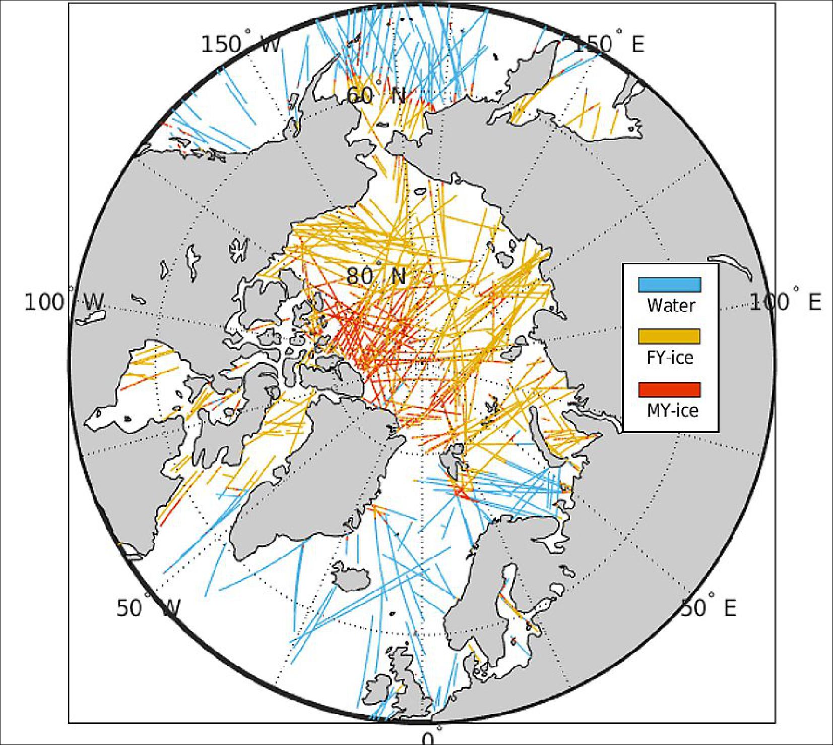
- NASA’s Commercial Smallsat Data Acquisition (CSDA) program is a component of NASA’s Earth Science Data Systems (ESDS) Program. Formerly known as the Private-Sector Small Constellation Satellite Data Product Pilot Project, CSDA was established in 2017 to identify, evaluate, and acquire remote sensing imagery and data that support NASA’s Earth science research and application activities. Spire was one of the original vendors selected as part of the pilot project.
- NASA researchers have used Spire data to support investigations into water and sea ice levels in the polar regions, the height of the Planetary Boundary Layer (PBL), and the day-to-day variability of thermospheric density at high altitudes. Spire data also have been used as inputs into the Goddard Earth Observing System (GEOS) Atmospheric Data Assimilation System, which uses space-based data to analyze Earth’s atmosphere and assimilate the data into its Earth observation systems.
• April 29, 2021: Spire Global Inc. (”Spire”), a leading global provider of space-based data and analytics, announced today the launch of a new platform and a new analytics product for the maritime industry. Spire Bridge and Spire Analytics will allow customers to create their own dashboards and alerts customized to their specific use cases. 41)
- Through the Spire Bridge portal, customers can now access our new product, Spire Analytics, to monitor data usage, get support, documentation, and product updates to activate and operationalize the data Spire measures and provides. Having a dedicated location for all of these features will allow data users to access insights and support faster.
- “After listening to our customers, the Maritime team has developed a platform for users to better access the data and information they need when they need it. Spire puts its customers first and Spire Bridge is a result of this philosophy,” said Simon van den Dries, General Manager, Spire Maritime.
- To expand Spire Maritime API data services, the team has introduced new analytics capabilities that provide valuable time savings for developers and data engineers. Spire Analytics transforms maritime data into actionable insights to help solve the Maritime industry’s business challenges. This tool allows customers to graph, report, and visualize the data. It can also filter searches by ship type, voyage, density map, and more. For customers looking for a faster way to get information about a fleet, port, anchorage, or terminal event, our easy-to-use dashboard can filter the information and deliver the data they need to make data-driven decisions, case by case, without all the background noise.
- Spire Maritime’s industry-specific dashboards are easy to use, customizable and deliver in-depth insights to help predict outcomes, test business strategies and automate decision making. These new features will allow Spire’s customers to use data in more actionable ways,” said Max Abouchar, Product Manager, Spire Maritime.
- As of January 2021, Spire Global has over 100 satellites in orbit that are collecting hundreds of million messages per day. Spire will continue to provide more data and insights to enable the digital transformation of organizations towards data-driven opportunities in the maritime industry.
• March 1, 2021: Satellite operator Spire Global has unveiled the space-powered Big Data market’s second SPAC deal in just over a week, as the rush to public markets accelerates across commercial space sectors. 42)
- Spire’s merger with SPAC (Special-Purpose Acquisition Company) NavSight values the company at $1.6 billion. The deal gives Spire about $475 million in cash to accelerate data-gathering and analysis operations across maritime, aviation, weather, climate and other markets.
- The cash injection includes $245 million from a group led by investors Tiger Global Management, BlackRock Advisors, Hedosophia, Jaws Estates Capital and Bloom Tree Partners. NavSight listed on the New York Stock Exchange in September in a $200 million deal under ticker symbol NSH.
- Spire plans to list on the same exchange under ticker SPIR this summer after shareholder and regulatory approvals – faster than a traditional route to becoming public that can take anywhere from six to 18 months.
- The company has been considering a public listing for a year and a half, CEO and founder Peter Platzer told SpaceNews.
- Spire spoke with “a substantial number of SPACs” during that time, Platzer said, before hitting it off with NavSight CEO Bob Coleman and CFO Jack Pearlstein in November.
- “This partnership will allow us to accelerate our market capture by investing in sales, marketing, and product development, and taking full advantage of the deep experience and relationships Bob and Jack bring to the table,” he said.
- In addition to their experience as public company executives, Platzer said Coleman and Pearlstein bring strong connections in the government market, an important customer group for Spire.
- Coleman, who has a history of founding and leading solutions providers for the intelligence community and Department of Defense, is an advisory board member for the National Defense Industrial Association.
- Pearlstein has more than 25 years of operating experience in the technology sector and, until June 2020, was CFO of public relations software company Cision.
Untapped Potential
- Surging popularity for SPAC deals in the investment community is creating a gold rush for commercial space companies, which tend to have sizable capital expenditure needs.
- Unlike some that have jumped on the SPAC bandwagon, however, decade-old Spire generates revenues with a constellation of more than 100 satellites that it builds in-house.
- It recorded about $36 million in unaudited recurring revenues in 2020, according to a Spire investor presentation, and expects to nearly double that this year. It also posted an $18 million gross profit last year (non-GAAP), expecting that to climb to $830 million in 2025 on nearly $1.2 billion in recurring revenues.
- Since 2012, Spire has secured around $180 million in capital from investors that include Bessemer Venture Partners, RRE Ventures, Scottish Investment Bank, Seraphim Capital and Lemnos. It now employs about 250 people, including around 140 engineers and scientists.
- Platzer said the transaction enables it to pursue a more aggressive timetable for its “space-as-a-service” growth model, where customers operate their own payloads and use their own software for accessing the data collected by its Lemur satellites.
A Healthy Trend?
- BlackSky, which provides Big Data analysis with a network of imagery and geospatial intelligence satellites, announced a SPAC deal Feb. 18 that values it at around $1.5 billion.
- Rocket Lab, which has launched some of Spire’s spacecraft, announced its own SPAC-fueled plans March 1 to go public. The group will use proceeds to develop a larger launch vehicle called Neutron, which will help serve growing demand for satellite constellations such as Spire.
- Other space ventures that have recently announced SPAC plans to, since Richard Branson helped open the flood gates with tourism venture Virgin Galactic in 2019, include rocket-maker Astra, satellite-to-device specialist AST & Science and space transportation venture Momentus.
- Analysts expect many more SPAC deals to come for an industry that has long pined for sizable exits, which are key for newspace to continue attracting capital across the value chain.
- However, the frenzy of activity also raises concerns about a potential bubble in the space community.
- The trend marks an inflection point for the newspace ecosystem, according to David Cowan, a partner of Bessemer Venture Partners that currently owns about 6.5% of Spire.
- “We now have public companies showing strong financial performance as they deploy microsatellite constellations,” Cowan told SpaceNews.
- “Not only [do SPACs] unlock public pools of capital, but we should now expect a huge uptick in venture capital investment behind the next-generation of space startups.”
- Spire is the second newspace company in VC firm Seraphim Capital’s portfolio to announce a SPAC, following AST & Science late last year.
- Seraphim Capital CEO Mark Boggett characterized the SPAC trend as a point of maturation for newspace, enabling these companies to build scale largely debt-free.
- “The newspace industry really lends itself to the SPAC proposition given the giant addressable markets for these companies,” Boggett said.
- “The first movers and the emerging category leaders can accelerate their vision whilst fully funding their growth plans through a single efficient transaction ... It’s great to see the SPAC focus broadening beyond the launch category and I expect we’ll see a sharp increase in further newspace SPAC announcements as we progress through 2021.”
• February 18, 2021: Spire Global announced today that it will be working with the European Maritime Safety Agency (EMSA) to provide global AIS data to support the Agency via it’s EU Member States. Automatic Identification System (AIS) is a global standard for ship-to-shore, and shore-to-ship communications and contributes to collision avoidance, search and rescue operations, and maritime domain awareness through vessel tracking. 43)
- The new SAT- AIS data feed is expected to complement the current SAT-AIS stream by also improving the global coverage of ships including waterways close to north and south poles. An additional SAT-AIS data stream will improve EMSA’s SAT-AIS data service it offers in terms of resolution of SAT-AIS data, and detection rate of AIS messages.
- “We are pleased to have been selected by EMSA for this mandate and to be providing satellite-AIS services to this vital maritime organization,” said Simon van den Dries, General Manager of Spire Maritime “We believe that Spire’s high reliability and quality of its data gathered by its fast growing satellite constellation – differentiates us in the industry and will help support EMSA’s vision and maritime strategy within the EU.”
- EMSA’s mission is to serve EU maritime interests for a safe, secure, green and competitive maritime sector and act as a reliable and respected point of reference in the maritime sector in Europe and worldwide. By partnering with Spire, EMSA will have better awareness of what, when and where vessels are around the world.
- EMSA has implemented a new Framework Contract with Spire Global. The new satellite AIS (SAT-AIS) feed will serve as a backup solution for the current EMSA SAT-AIS data services EMSA offers through its Integrated Maritime Services (IMS). IMS are offered to all EU and European Free Trade Agreement Member States. Member States can make full use of a range of integrated vessel reporting information from terrestrial and satellite AIS, Long-range identification and tracking (LRIT), Vessel Monitoring System (VMS), as well as national vessel position data such as coastal radar, patrol assets, and leisure craft.
- As of January 2021, Spire Global has over 100 satellites on orbit that are collecting hundreds of million messages per day. Spire will continue to provide more data and insights to enable the digital transformation of organizations towards data-driven opportunities in the maritime industry.
• February 1, 2021: Orbitare, an innovative start-up developing Internet Protocol (IP) communications over their own satellite network, and Spire Global, one of the world’s largest space-powered Earth Information companies, today announced the execution of an agreement to begin deploying Orbitare’s Spaceloop on Spire’s nanosatellite constellation starting with a dual-mission in-orbit validation of its communications protocols. 44)
- Spaceloop is Orbitare’s personal satellite communication network in Low Earth Orbit developed and built in Europe and designed to deliver IP messaging, email and file transfer capabilities to any location in the world, at the most affordable price and ease of use. Spaceloop aims at keeping people always safe and connected, and will allow Orbitare to provide services dedicated to both personal safety – be it at sea, in the mountains or wherever the land network may not be accessible – and to fulfil the growing need for connectivity for social and professional reasons. The development of Spaceloop is co-funded by the Government of Luxembourg within the Luxembourg National Space Programme LuxIMPULSE, which aims at providing funding to help companies established in Luxembourg to bring innovative ideas to market. The programme is managed by the Luxembourg Space Agency and implemented by the European Space Agency. The early demonstrator missions will leverage Spire’s advanced Software Defined Radios (SDRs) infrastructure to host Orbitare’s Spaceloop communications protocols as early as April 2021. Following its success, both companies are looking into further expansion of the Spaceloop service across other satellites in the Spire constellation which will facilitate early and fast access to market and further increase the reach of Orbitare’s satellite fleet.
- “We are proud to partner with Spire on the development and deployment of Spaceloop. Our teams are enthusiastically working together to get the demonstration mission of Spaceloop rapidly into space”, said Luis Muñoz, founder and Managing Director of Orbitare. “Thanks to Spire’s Orbital Services, the deployment of our commercial services will be significantly accelerated, allowing Orbitare to reach our customers at a much earlier stage. Moreover, running Spaceloop on Spire’s satellites and ground stations gives Orbitare access to a much larger footprint at no additional capital expenditure. This partnership gives us a level of flexibility that is hard to find in the market.”
- In April 2021, Spire will host Spaceloop’s communication software on a software-defined radio (SDRs) on board one of the in-orbit Low Earth Multi-Use Receiver (LEMUR) 3U satellites in a unique approach to space that will allow Orbitare the early start of live communication tests.
By June 2021, Spire will fly Orbitare’s first full-duplex Spaceloop communications payload, developed also in cooperation with Orbitare, to showcase additional comms capabilities. The demonstration program will use Orbitare’s reference end-user terminals and a gateway located in Luxembourg. Spire will manage all satellite operations through its Missions Operation System and Orbitare will access the payload through an easy-to-use customer API.
- With this partnership Spire commercializes a new Space as a Service subscription model allowing Orbitare to implement its mission at competitive price and without heavy upfront capital expenditure. Spire’s Orbital Services monthly payment plan benefits their customers by reducing high upfront expenditures, enabling predictable service charges distribution, and allows an easier extension of the service provision beyond the lifecycle of the hardware.
- “We are extremely proud to host Orbitare’s Spaceloop service and use our Orbital Services to provide them the resources they need in space, on the ground and in the cloud. With our technical and operational expertise paired with a simplified service model we assure Orbitare the fastest, easiest, and most reliable access to Space and roadmap for growth,” said Theresa Condor, GM Orbital Services, Spire Global.
- This commercial agreement between Orbitare and Spire demonstrates broad collaboration and innovation capabilities offered within the growing New Space community in Luxembourg, of which both companies are part.
• January 26, 2021: New collaboration powers Maersk Tankers and Cargill-invested ZeroNorth’s vessel optimization software with Spire’s data, driving impactful revenue and sustainability decision-making. 45)
- Maritime technology company ZeroNorth and leading global satellite and data company Spire Maritime have today announced a new partnership that powers up ZeroNorth’s vessel optimization software Optimise with Spire’s world-leading maritime AIS and weather data.
- ZeroNorth’s Optimise software supports operators of ‘tramp’ ships – those with no fixed route or schedule – to increase their revenue and cut emissions by using vast amounts of marine data to make recommendations on vessel speed and when, where and what to refuel a vessel with, turning data into action. Cumulatively, these decisions can generate significant emissions savings and increase revenue for a ship operator, because operating a vessel at the right speed at any given moment throughout a voyage can reduce fuel consumption.
- Weather and sea condition have huge implications on vessel efficiency. Having an accurate picture of the open ocean is therefore vital for both realizing better safety outcomes and improving the performance of the commercial shipping fleet.
- Currently, outside of the Paris Climate Agreement, the global shipping industry is under considerable pressure to find solutions to decarbonize, improve its sustainability and reduce its impact on the environment. International shipping is responsible for approximately 2.5% of global CO2 emissions – roughly equivalent to Germany’s annual emissions output.
- If all 33,000 vessels in the global tanker and dry bulk fleet were using Optimise, more than 50 million metric tons of CO2 emissions would be eliminated over the next five years.
- The new partnership with Spire means that Optimise and its emissions-saving recommendations will be powered up by Spire’s market-leading weather and vessel location, or AIS, data. Thanks to a combination of satellite and terrestrial technologies, the data gathered by Spire is some of the most comprehensive on the market.
- While weather stations and sensors are widespread on land, the same cannot be said for open oceans. Spire overcomes this limitation by using remote sensing techniques such as satellite radio occultation. It allows the capture of detailed temperature, humidity, and pressure information across the entire planet, including our vast oceans’ under-observed corners. The resulting boost to weather prediction is beneficial to both the global maritime industry and global forecast models.
• November 23, 2020: NOAA (National Oceanic and Atmospheric Administration) awarded its first contracts Nov. 20 to purchase GPS-RO (Radio Occultation) data from commercial satellite operators GeoOptics and Spire Global. 46)
- The Nov. 20 awards are the culmination of years of work by both companies to develop, manufacture and operate satellites to gather atmospheric temperature, pressure and water vapor observations to feed into operational weather forecasts.
- The two-year indefinite delivery-indefinite quantity contracts awarded to GeoOptics and Spire Global have a total ceiling of $23 million. On Nov. 20, NOAA also awarded initial task orders to both companies but did not reveal the value of those orders.
- Since 2016, NOAA has scrutinized radio occultation data provided by private companies through the Commercial Weather Data Pilot. In June, the agency issued a report that concluded, “the commercial sector is capable of providing the quality of data needed to help support NOAA’s operational weather forecasting needs.”
- NOAA has a target of acquiring 20,000 soundings per day, Steve Volz, NOAA assistant administrator for satellite and information services, said in January at the American Meteorological Society’s conference in Boston. A significant portion of the data are likely to come from the six satellites that make up the second U.S.-Taiwan Constellation Observing System for Meteorology, Ionosphere and Climate (COSMIC) constellation launched in 2019.
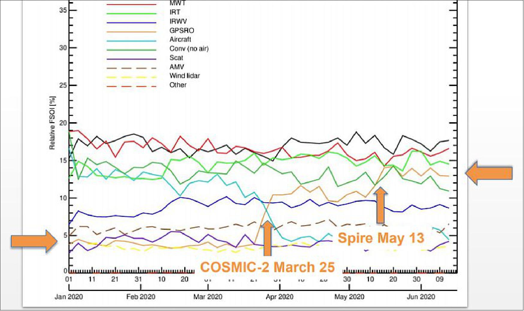
- Spire Global operates a constellation of more than 100 Lemur CubeSats with multiple sensors to track ships at sea, an aircraft in flight in addition to obtaining atmospheric data by noting how signals from global navigation satellites like GPS travel through the atmosphere.
- “We are pleased that NOAA has selected Spire for the operational procurement of radio occultation,” Keith Johnson, Spire Global vice president and general manager – federal, told SpaceNews by email. “Our missions are synergistic and we look forward to a long and happy partnership. We believe this represents both an amazing third-party validation as it deeply illustrates the kind of collaboration that is possible between public and private institutions to support such a critical service for people and businesses around the world.”
- GeoOptics focuses exclusively on weather data with a smaller constellation of CubeSats called CICERO (Community Initiative for Cellular Earth Remote Observation) that are roughly twice the size of Lemurs. GeoOptics does not publicly discuss the size of its constellation.
- “GeoOptics is very pleased and excited about our new contract with NOAA,” GeoOptics CEO Conrad Lautenbacher told SpaceNews by email. “We look forward to providing top-of-the-line radio occultation data for use in National Weather Service forecasts.”
- During the Commercial Weather Data Pilot, NOAA evaluated data from 12 Lemurs and two CICEROs.
• On 28 September 2020 (11:20 UTC), four Lemur-2 nanosatellites (3U CubeSats) of Spire Global, San Francisco, were launched as secondary payloads from the Plesetsk Cosmodrome site 43/4 in Russia on a Soyuz-2.1b/Fregat vehicle. 47)
- The Glaswegian-built nanosatellite joins a fleet of about 100 objects in low Earth orbit that help to predict the movement of the world’s resources, so that businesses and governments can make informed decisions.
- The satellites have been built by Spire Global UK, a satellite-powered data company that provides predictive analysis for global shipping, aviation and weather forecasting.
- These services have been developed thanks to the UK Space Agency under the ESA Pioneer Partnership Project.
- Spire uses automatic identification systems aboard ships to track their whereabouts on the oceans. Its network picks up the identity, position, course and speed of each vessel.
- Thanks to embarked intelligent machine-learning algorithms, it can predict vessel locations and the ship’s estimated time of arrival at port, enabling port authorities to manage busy docks safely and market traders to price the goods carried aboard.
- Spire staff design and build all the subsystems, and integrate and test the whole spacecraft in the company’s Glasgow headquarters.
- Two of the four Spire nanosatellites have an onboard supercomputer and intelligent machine-learning algorithms that can provide hyper-accurate predictions of the locations of boats, track their whereabouts and calculate their arrival times at ports, allowing port businesses and authorities to manage busy docks safely. Two further Spire satellites launched alongside them, both of which will be used to forge inter-satellite links. These connections allow satellites to act as relays, sending data to one another and down to ground stations, which cuts the time between data collection and its delivery. - Made by Spire Global UK, the nanosatellites, which are some of the smartest satellites ever built in the UK, are backed by over £10 million of investment from the UK Space Agency. 48)
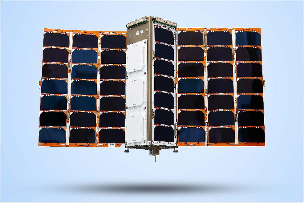
• September 11, 2019: Spire Global unveiled Spire Forecast Sept. 11, a product designed to provide the maritime industry with detailed information on atmospheric conditions including global sea surface temperatures, ocean currents, wave heights, surface winds and air temperature. 49)
- Spire Forecast is the first product from the Spire Weather business unit.
- “We created Spire Weather to augment and support the global weather prediction industry, from the private sector to government organizations who provide daily predictive weather information to global businesses and the world,” John Lusk, general manager for Spire’s commercial business units, said in a statement.
- Founded in 2012, Spire gathers weather data in addition to tracking ships and aircraft with a fleet of more than 70 CubeSats in low Earth orbit.
- Since its inception, Spire has focused on radio occultation, measuring atmospheric temperature, pressure and water vapor by observing the impact of those variables on radio waves. Spire announced on 9 September that its constellation collects 5,000 daily radio occultation profiles.
- “Spire is working to create new tools to aid in this joint effort to illuminate the Earth,” Alexander “Sandy” McDonald, Spire Weather director, said in a statement. McDonald served previously as director of the NOAA's (National Oceanic and Atmospheric Administration’s) Earth System Research Laboratory.
- “We are offering global organizations and in particular the national [meteorology] centers like NOAA a way to vastly improve weather forecasts for public safety,” McDonald said.
- Spire is developing information products for specific industries and market segments. Spire announced the creation in February of its Spire Maritime business unit. Spire announced an agreement in August to share data and develop products alongside Concirrus, a London-based insurance analytics company.
• August 14, 2019: Spire Global and Kleos Space S. A. of Luxemburg are combing forces to combine Spire AIS data with KLEOS RF data to create a new shared capability to bring safety at sea. 50)
- Kleos and Spire have entered into an agreement to cooperate on creating enhanced tools for maritime safety. The effort will support and augment tools for governments, maritime agencies, and all organizations with strategic interest in detecting dark vessels.
- The two companies, both with operations in Luxembourg, will introduce the new product offering in Q4 of this year — Spire data will now include with Kleos’ RF Reconnaissance data products, which are available on the site in three levels — Guardian RF, Guardian LOCATE and Guardian UDT — and can be pre-ordered by registered users on a monthly or annual basis. Spire will deliver proprietary AIS data to the RF data Kleos providers in these situations where AIS is undetected.
- This partnership represents the first time that AIS provider and RF Satellite provider have signed an agreement where these datasets can be easily integrated. And the first time two New Space organizations based in Luxembourg have partnered up to strengthen safety at sea.
- John Lusk, GM, Spire Maritime, said that the company shares a desire to illuminate parts of the world, just as Kleos does — the firm continue to partner with the most innovative industry experts to create new access to highly relevant datasets for customers worldwide. Spire Global's reputation for valuable data is due to the company's large constellation of fully owned and operated satellites that offer data and analytics for parts of the world where collecting data is notoriously difficult. The company recently created Spire Maritime, which closed out 2018 with 160% year-over-year revenue growth. The new effort is pushing the Satellite AIS maritime segment forward with unique innovations in product creation.
• July 5, 2019: The latest ESA Partnership Projects mission has launched two tiny supercomputing nanosatellites, namely Lemur-2 3U CubeSats (100 series) of Spire Global, aboard a Soyuz rocket from Vostochny in Russia. 51)
- The parallel supercomputing scalable devices, aboard the lightweight 3U CubeSats of Spire Global can be programmed to both receive and process data while in orbit. This enables them to select high-quality data and immediately transfer it to Earth.
- Their owner, Spire Global, specializes in using continuous global monitoring to track aircraft, ships and weather patterns using a large constellation of 80 nanosatellites that report to a global network of ground stations.
- The two new satellites, developed under ESA’s Pioneer program, were designed, built and tested at Spire Global’s factory in Glasgow, with support from the UK Space Agency. - They were launched aboard a Soyuz-2.1b/FregatM vehicle with the Meteor-M2-2 primary mission on 5 July 2019.
- Peter Platzer, chief executive of Spire Global, said: “We see these parallel supercomputing scalable satellites as being extremely important for the next phase of Earth observation applications for the benefit of all mankind. Just one of our small satellites can collect over a terabyte of data per day, which would be prohibitive to download. It has to be analyzed in orbit so that true insights can be delivered to customers directly and in a timely fashion. A hurricane does not wait for a download window. It is exciting to see ESA's continued support and focus on deploying these necessary data analytics and capabilities.”
- Khalil Kably, pioneer program manager at ESA, said: “The whole idea of the Pioneer program is to give European and Canadian industries access to space, rapidly and at low cost. - As soon as they have an innovative idea, such as supercomputing by Spire here, we want them to be able to try it in orbit. It’s the ability to go from a new idea to market very quickly, through in-orbit validation.”
• June 6, 2019: German launch services provider Exolaunch is providing launch services and mission management for eight Spire Global satellites scheduled for liftoff July 5 on a Russian Soyuz rocket, the two companies said June 6. 52)
- Spire launched its 100th satellite in April to supply weather data in addition to tracking ships and aircraft. Spire has relied on Exolaunch to arrange launches and oversee integration for dozens of its triple CubeSats since the two companies began working together in 2016.
- The eight new satellites slated for launch in July are meant to refresh Spire’s constellation.
- “EXOLAUNCH is one of our most trusted launch partners and we look forward to continuing this successful relationship,” Jenny Barna, Spire launch director, said in a statement. “They bring extensive launch expertise, best-in-class deployment hardware and a great team supporting every aspect of the launch campaign.”
- In addition to arranging launches, Exolaunch has developed its own line of deployers and separation systems for CubeSats and microsatellites. Exolaunch began integrating Spire’s eight new CubeSats with deployers in late May at Spire’s office in Glasgow, Scotland.
- “Now the team is heading to the launch site to get ready for the final integration with the launch vehicle,” Jeanne Medvedeva, Exolaunch launch services commercial director, said by email.
- On the upcoming launch, the Soyuz rocket upper stage is expected to drop off satellites in three different sun synchronous orbits, releasing the primary payload, Russia’s Meteor M2 weather satellite, at an altitude of 830 kilometers, microsatellites at 580 kilometers and CubeSats including Spire’s Lemurs at 530 kilometers.
- “As a data and analytics company that collects unique data from space to solve real problems on Earth, while managing one of the largest satellite constellations in the world, Spire has exceedingly high standards,” Medvedeva said in a statement. “Exolaunch is proud to be a key partner facilitating the ongoing success of the constellation launch.”
- Exolaunch is integrating 35 small satellites on the July Soyuz flight. Exolaunch planned to handle even more satellites but some CubeSats were not ready. Customers “needed more time to finish their satellites or to coordinate frequencies with the International Telecommunication Union,” Medvedeva said by email. “We were flexible with the back-up launch options.”
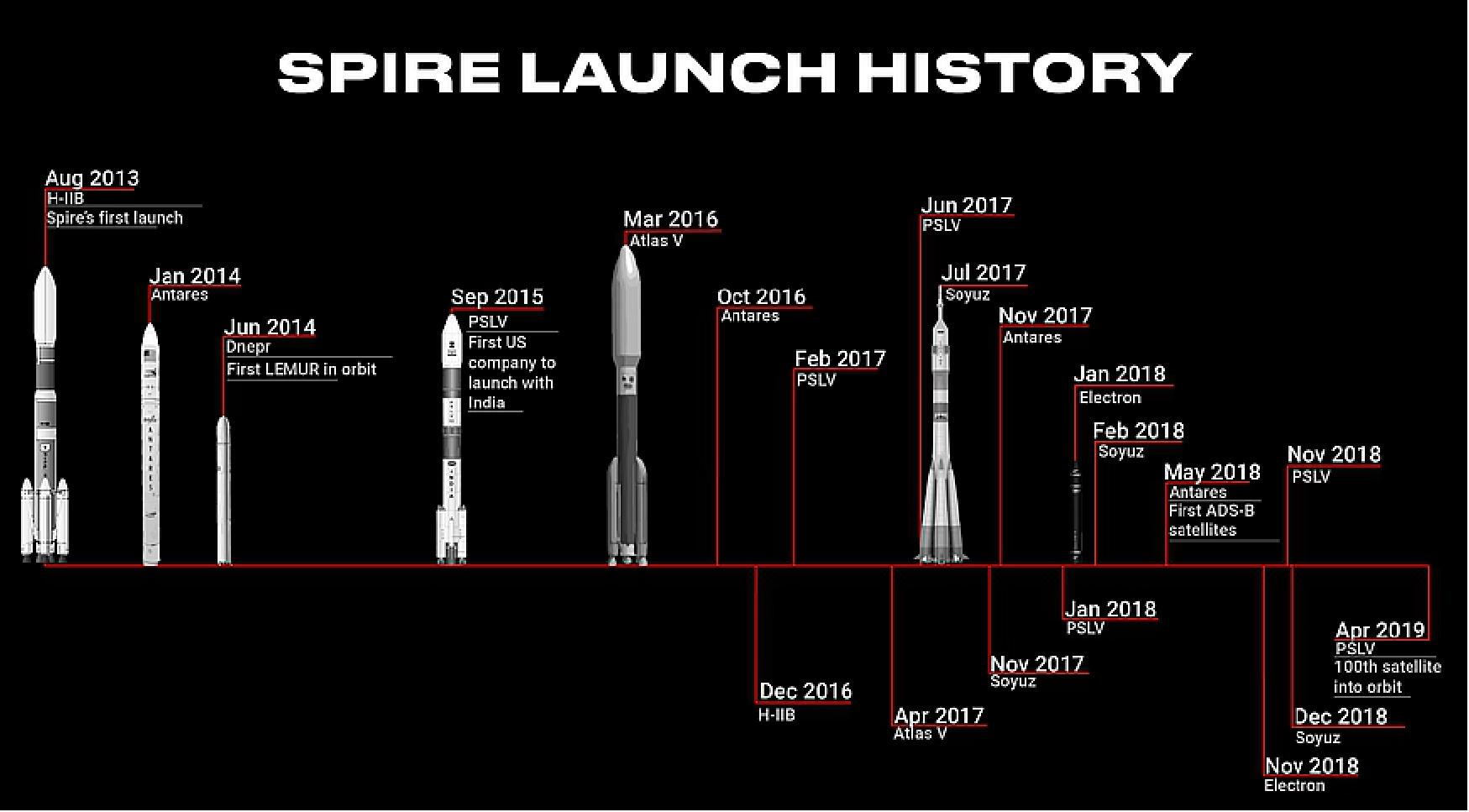
• May 1, 2019: Spire Global, one of the world's largest space to cloud analytics companies, today announced they will provide Automatic Identification Systems (AIS) data for BAE System’s GXP® software. BAE Systems will include Spire’s data in its Geospatial eXploitation Products™ (GXP) software solutions, which offer advanced geospatial intelligence through an unrivaled capacity for the discovery, exploitation, and dissemination of mission-critical geospatial data. 53)
- BAE Systems and Spire will integrate their industry leading technologies to offer an integrated solution that delivers a deeper, more accurate geospatial intelligence capability via GXP’s software tools.
- "I am so excited about our collaboration with GXP. As the leader in geospatial solutions, BAE Systems’ GXP Xplorer® platform can now provide its customers with the Spire data set to help meet its critical missions,” said Keith Johnson, VP and GM Spire Federal. “This new relationship creates a set of previously unavailable tools that can now be used as a unique daily resource.”
- Spire has become an industry standard in the commercial aerospace sector and operates one of the largest constellations of private nanosatellites and ground station networks in the world. The company has launched several new strategic partnerships this year, including deals with NASA, ESA and key global players in the weather, maritime and aviation sectors.
• April 5, 2019: Spire Global, which just launched its 100th satellite to space aboard an Indian rocket, has a strong vision to fuel the young firm. It wants to help its customers — ships on the high seas, workers in remote construction areas, insurance companies trying to make risk assessments — deal with the uncertainty from climate change. 54)
- It's a big vision for a company with under 200 employees, but Spire works to achieve this through multi-purpose satellites. Its competitors, Spire CEO Peter Platzer said, focus on optical imagery. It's possible to take images with a small-satellite constellation, but the challenge is, better-resolution images usually require bigger lenses. As he put it: "To increase the resolution to count the cars [on a highway], you can't do this with more satellites — you need a bigger satellite. Then to read the license plate on the car, you need an even bigger satellite."
- So that's why Spire focuses on using radio frequency signals to cover the Earth. Right now it has 76 satellites on orbit and can cover virtually the entire globe, pole to pole — which is a big deal as the north opens up more to exploration and industry. And as they add more satellites to the constellation, they will track even more. So it's not size that matters, but quantity. "If you want to track aircraft every hour, you can't do that with a bigger satellite," he explains. "You just need more satellites. It's a geometry problem. The value of the data increases with the number of sensors."

- Spire started off with institutional investment and rapidly raised Series A, B and C rounds since its founding in 2013. (It's illegal to disclose whether the company plans another round of funding, Platzer explained.) Since the company is privately held, it can only disclose a portion of its balance sheet. Platzer explained that revenues are "well into the eight-figure range", and growing year-over-year in triple digits.
- In the maritime business alone, customers have doubled quarter-over-quarter. "It's really picking up speed," he said, adding that strong growth is also seen for weather forecasting.

• November 21, 2018: ESA and Spire are pleased to announce the opportunity to freely access, up to March 2019, through the Third Party Mission program, 6 different samples of global Spire satellite data. The data collected by Spire has a diverse range of applications, from analysis of global trade patterns and commodity flows to aircraft routing to weather forecasting. The data also provides interesting research opportunities on topics as varied as ocean currents and GNSS-based planetary boundary layer height. 55)
- ESA promotes this opportunity as a data familiarization phase before the potential formal integration into the Third Party Mission program of the ESA Earthnet activities.
- The data will be accessible directly via the Spire delivery system.
• October 04, 2018: NASA has launched a pilot program to evaluate how Earth science data from commercial small-satellite constellations could supplement observations from the agency’s fleet of orbiting Earth science missions. On 28 September, the agency awarded sole-source contracts to acquire test data sets from three private sector organizations. 56)
- NASA’s Earth Science Division in Washington issued blanket purchase agreements for the “Private Sector Small Constellation Satellite Data Product Pilot” program. Under these agreements, the agency purchases data sets and related products based on observations derived from Earth-orbiting, small-satellite constellations designed and operated by non-governmental entities.
- “This pilot program is an innovative and efficient way for us to acquire, examine, and evaluate a wide range of private sector Earth observation data,” said Michael Freilich, director of NASA’s Earth Science Division. “As our very capable NASA research satellite fleet ages and more small satellites are launched by private industry, there are opportunities to leverage the strengths of each into even more complete climate data sets.”
- NASA will provide the test data products to NASA-funded researchers, who will examine whether the data help advance the agency’s science and applications development goals. The pilot program is designed to determine whether these private sector observations and associated products offer a cost-effective means to augment or complement the suite of Earth observations acquired directly by NASA, other U.S. government agencies, and international partners.
- The contracts were awarded to:
1) DigitalGlobe, a Maxar Technologies company headquartered in Westminster, Colorado, has five very high-resolution Earth imaging satellites (GeoEye-1, WorldView-1, WorldView-2, WorldView-3, WorldView-4) capable of collecting 30 cm resolution imagery.
2) Planet, headquartered in San Francisco, has three satellite constellations (SkySat, Dove, RapidEye) with more than 150 satellites supplying imagery and derived products over the entire Earth at medium and high resolution with high repeat frequencies.
3) SPIRE Global, headquartered in San Francisco, operates a constellation of over 60 Lemur 3U CubeSats collecting radio occultation soundings, aircraft location information and ship reports. GPS radio occultation measurements can be used to sound the atmosphere for temperature, water vapor, and atmospheric pressure.
- These contracts represent the first time that NASA has engaged with commercial small-satellite constellation operators to purchase their data for scientific evaluation. They establish a way for NASA to acquire and examine the data products during the next 12 months. Each contract includes an option for NASA to extend the agreement for an additional four years, for a total value of up to $7 million for each of the three agreements.
- To be considered for participation in this pilot program, companies had to demonstrate they were currently operating a small satellite constellation of no fewer than three satellites in non-geostationary orbit and producing consistent global coverage. Companies also were asked to supply a comprehensive catalog of their data, describing areal coverage, data latency, pricing, and other factors.
- NASA uses the vantage point of space to understand and explore our home planet, improve lives and safeguard our future. The agency’s observations of Earth’s complex natural environment are critical to understanding how our planet’s natural resources and climate are changing now and could change in the future.
• September 20, 2018: NOAA (National Oceanic and Atmospheric Administration) awarded more than $8 million in contracts this week to three companies in the second round of a commercial satellite weather data pilot program. 57)
- In the Sept. 17 announcement, NOAA said it was issuing contracts to GeoOptics, PlanetIQ and Spire to provide GPS radio occultation weather data from satellites currently in orbit or planned for launch in the coming months. That technique measures the refraction of GPS signals as they pass through the atmosphere and are received by the companies’ satellites, which can provide temperature and pressure profiles to support weather forecasting models.
- The awards represent round two of NOAA’s Commercial Weather Data Pilot program, an effort by the agency to experiment with buying data from commercial providers to determine its usefulness, as well as to examine various technical and programmatic issues with such data buys.
- “These contracts represent another step toward bringing commercial sector innovation to NOAA’s mission of delivering life-saving weather forecasts and warnings,” said Karen St. Germain, director of the Office of Systems Architecture and Advanced Planning for NOAA’s Satellite and Information Service, in a statement. “By collaboratively testing commercial sector capabilities and new business models, we continue to optimize the impact of our observations and reduce costs for taxpayers.”
- In round one of the program, NOAA awarded contracts valued at a little more than $1 million in September 2016 to GeoOptics and Spire. However, GeoOptics was not able to provide any data because its first satellites had not launched before the window for providing data under the contract closed in April 2017.
- GeoOptics, which received a $3.44 million contract in round two of the program, now has at least two of its Cicero satellites in orbit, launched as secondary payloads on Polar Satellite Launch Vehicle missions in June 2017 and January 2018. A third awaits launch on a Rocket Lab Electron mission now scheduled for November after a series of technical issues with the rocket. Three others were launched on a Soyuz in July 2017, but are believed to be among the several satellites on that mission that failed after reaching orbit.
- “We look forward to working with NOAA to demonstrate the power of GeoOptics’ CICERO constellation to deliver reliable, high-quality data for weather forecasting,” said Conrad Lautenbacher, chief executive of GeoOptics and a former NOAA administrator, in a statement.
- Spire, which did provide data to NOAA under its earlier contract, received the smallest of the three awards, at $1.425 million. However, Spire Chief Executive Peter Platzer said he was not concerned about the size of the contract.
- “We are definitely celebrating winning yet another contract from NOAA,” he said Sept. 20. “Since Spire is the only company that has successfully delivered to NOAA already, I think NOAA decided they didn’t need as long a performance period from us and instead needed to focus the second test more heavily on unproven companies.”
- PlanetIQ, the newcomer to the program, also received the largest award, at $3.5 million. The Golden, Colorado-based company has yet to launch any satellites, even as its website states that it plans to have “12 microsatellites on orbit by early 2018.”
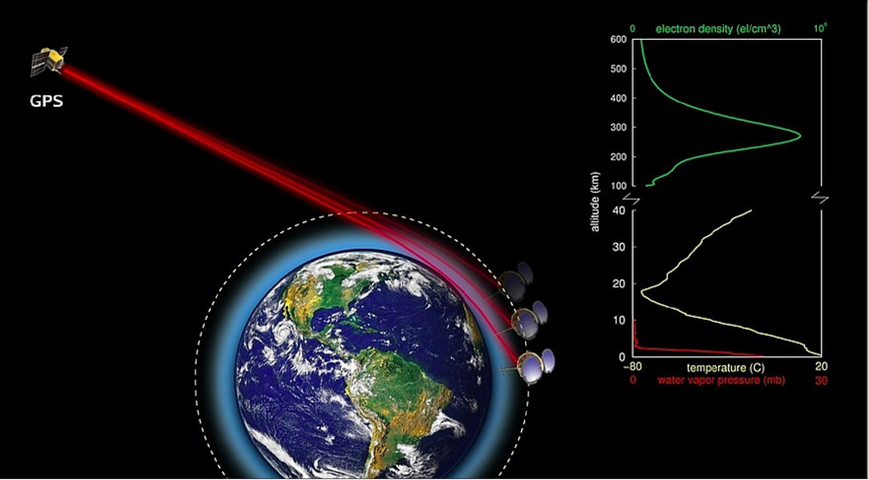
- PlanetIQ, the newcomer to the program, also received the largest award, at $3.5 million. The Golden, Colorado-based company has yet to launch any satellites, even as its website states that it plans to have “12 microsatellites on orbit by early 2018.”
- Steve Joanis, chief executive of PlanetIQ, said Sept. 19 that the company plans to launch its first two satellites in the first or second quarter of 2019. He did not state when the company expected to have its full constellation in orbit, or its size.
- Under the new contracts, the companies will deliver data through July 2019, with new “additional operational considerations” regarding the delivery of the data. The agency plans to complete its assessment of the data received and produce a final report by the spring of 2020.
• January 10, 2018: Spire Global, the San Francisco-based company that operates 48 GPS radio occultation CubeSats, could provide a persistent view of about 97 percent of Earth with a constellation of 150 satellites, said Alexander “Sandy” MacDonald, Spire’s global validation model director. 58)
- “It would be like a global GEO satellite and there are huge implications of that,” MacDonald, former director of the National Oceanic and Atmospheric Administration’s Earth System Research Laboratory in Boulder, Colorado, said Jan. 9 at the American Meteorological Society meeting here. 59)
- Spire is not alone in seeing the value of GPS radio occultation. NOAA and Taiwan’s Ministry of Science and Technology are preparing to launch six Constellation Observing System for Meteorology, Ionosphere, and Climate (COSMIC) 2A satellites this year on a SpaceX Falcon Heavy rocket. GeoOptics of Pasadena, California, is another startup working to establish a constellation of GPS radio occultation satellites.
- A constellation of 100 to 200 radio occultation satellites, which provide detailed observations of atmospheric temperature and moisture, could be used in conjunction with geostationary weather satellites like NOAA’s GOES-16 (Geostationary Operational Environmental Satellite-16) to dramatically improve the accuracy and spatial resolution of global weather prediction models, MacDonald said.
- Spire is building one satellite per week in its factory in Scotland, but could produce its three-unit CubeSats more quickly. “I think we could turn them out at two or three or five per week,” MacDonald said.
- Spire also is expanding its ground network. The company has 27 ground stations operating and is pushing to increase that number to 50 because the added ground stations will allow the firm to provide customers with data no more than 30 minutes old, MacDonald said.
- In addition to using its spacecraft for meteorology, Spire’s CubeSats carry Automatic Dependent Surveillance-Broadcast (ADS-B) payloads for aircraft tracking and Automatic Identification System (AIS) payloads for maritime tracking. “We collect about 10 million ship reports a day,” MacDonald said.
• In September 2016, NOAA made its first two awards under the Commercial Weather Data Pilot program created by Congress last year. The winners are Spire Global of San Francisco with the Lemur constellation and GeoOptics of Pasadena, CA with the CICERO constellation, both of which will provide radio occultation data to NOAA for evaluation to determine whether commercial data can be incorporated into NOAA’s numerical weather models. 34) 35)
- Congress provided $3 million to NOAA in the FY2016 Commerce, Justice, Science appropriations act (Division B of the FY2016 Consolidated Appropriations Act) for the pilot program. It required NOAA to enter into at least one pilot project through an open competitive process to purchase, evaluate and calibrate commercial weather data and to submit a report on how it would implement the project. NOAA publicly released that report in April.
- The idea originated in the House-passed Weather Research and Forecasting Innovation Act (H.R. 1561) sponsored by Rep. Frank Lucas (R-OK) and Rep. Jim Bridenstine (R-OK). Bridenstine chairs the Environment Subcommittee of the House Science, Space, and Technology (SS&T) Committee and also serves on the House Armed Services Committee. He led efforts to include a provision in the pending FY2017 National Defense Authorization Act for DOD to create a similar program.
- Under the contracts, the two companies will provide GNSS radio occultation data to NOAA by April 30, 2017 to demonstrate data quality and potential value to NOAA’s weather forecasts and warnings. NOAA/NESDIS (National Environmental Satellite, Data, and Information Service) will assess the data through the end of FY2017 and issue a report in early FY2018. The contract award amounts were $370,000 for Spire and $695,000 for GeoOptics.
- NOAA already uses GPS radio occultation (GPO-RO) data in its forecasts. The data are acquired by the six-satellite Formosat/COSMIC constellation, a joint program with Taiwan. NOAA is requesting funds for a COSMIC-2 follow-on.
• Prior to the NOAA contract, Spire already built commercial demand for its services from other customers. In addition to other weather agencies, Peter Platzer, CEO of Spire Global, said there are multiple markets beyond just government that have an interest in limiting the economic impact of extreme weather events by using space-based observations. 36)
- “Our customers are organizations that are highly knowledgeable in the weather space that have the capability to run numerical weather prediction models, and hence have the skill to consume GPS-RO data. There are significantly more private organizations and nongovernmental organizations that actually have this capability than we were aware of,” said Platzer.
- Spire presented the world’s first commercially collected and processed GPS-RO profiles this year at the IROWG (International Radio Occultation Working Group) conference. Platzer said the company was able to demonstrate that a commercial company could collect GPS-RO profiles and perform the necessary processing to convert them to atmospheric profiles. While highlighting that this feat was something many doubted could be done commercially, Platzer quickly adds that Spire relied heavily on government-supported research from NOAA, NASA, the Alfred Wegener Institute, the DLR, and others.
• While GeoOptics and Spire Global were awarded this first contract by NOAA, another company, PlanetiQ of Boulder, CO, also has plans to launch weather satellites in early 2018.
Sensor Complement
About 1U free space is available on each satellite for a hosted payload.

STRATOS
STRATOS is the Spire GNSS receiver for remote sensing & precision orbit determination:
• Performs POD (Precise Orbit Determination) using the zenith L1, L2 antenna
• Performs radio occultation (RO) on high-gain, side-mounted L1, L2 antennas
• Currently enables atmospheric & ionospheric remote sensing
• Applications: weather model assimilation of RO, space weather monitoring, ionosphere corrections for navigation, thermospheric density (POD)
• Currently modifying STRATOS for passive bistatic radar (GNSS-R) applications.
STRATOS makes use of GPS occultation measurements to determine temperature, pressure and humidity profiles of Earth’s atmosphere for application in operational meteorology. The instrument consists of GPS receivers to track the signals of several MEO satellites and measure the time delay and bend angle of signals that travel through the atmosphere located in the line of sight of the two spacecraft. These phase delay measurements due to refraction by the atmosphere can be made from the satellite altitude to very close to the surface leading to precise information on the properties of the atmosphere at an accurate vertical resolution. 60)
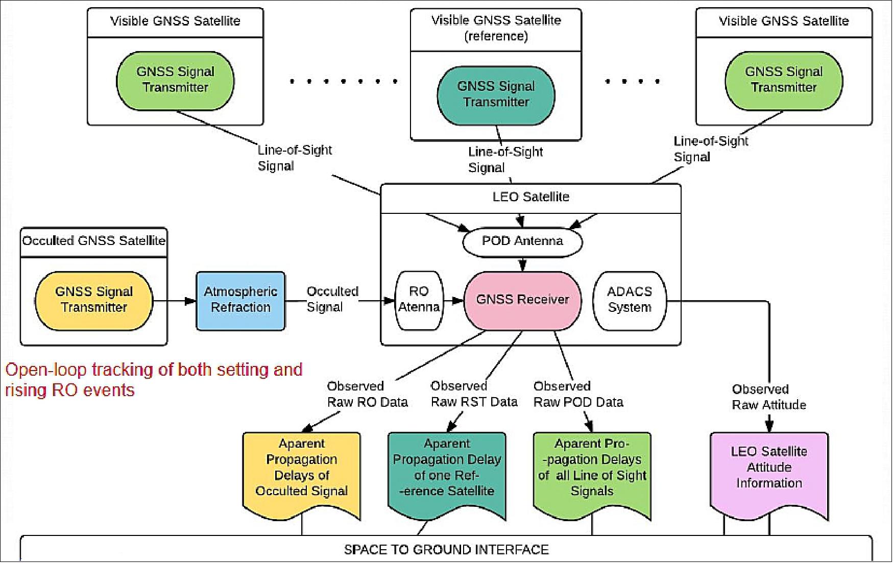
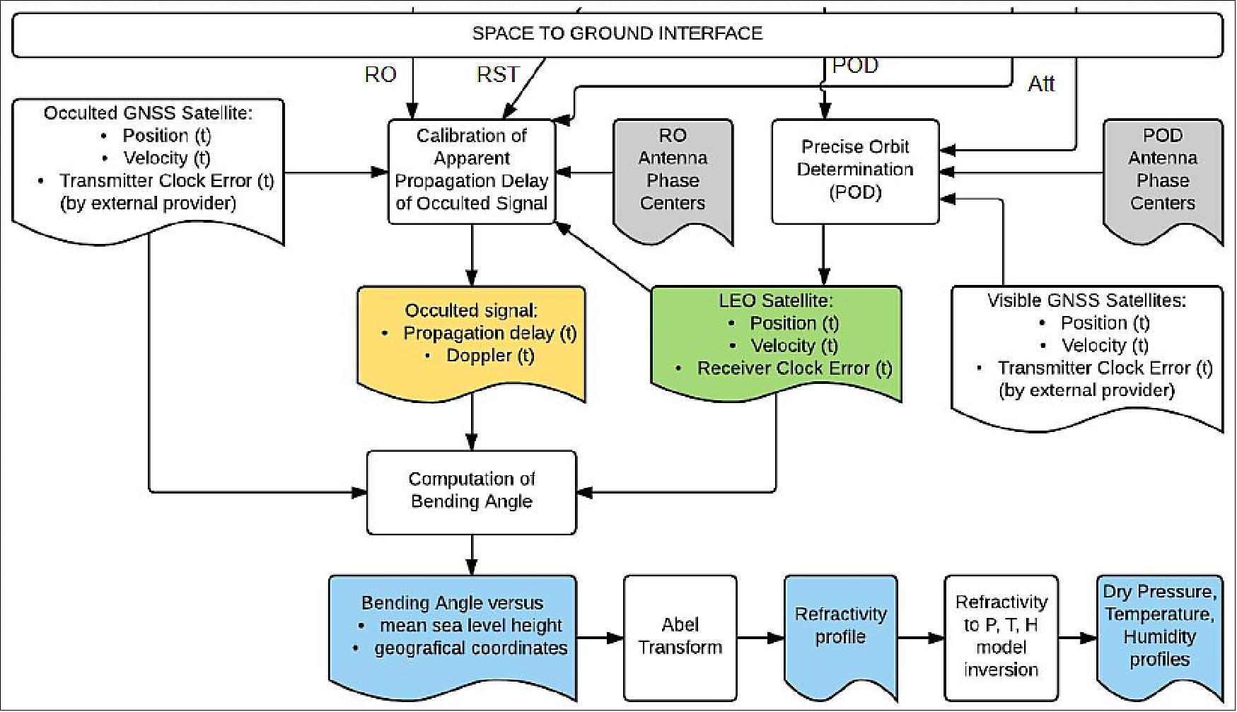
GNSS-RO Radio Occultation) Observables
• RO observables
- L1a: GNSS L1/L2 signal excess phases
- L1b: bending angle
- L1c: refractivity profiles
- L2: “dry” temperature, pressure (~6-70 km, although climatology dominates above ~50 km), “wet” temperature, pressure, water vapor pressure (< 6 km)
• Vertical sounding resolution: ~100 m
• Along-track resolution: ~200 km
• Across-track resolution: ~1 km
• Accuracy: ~0.5 K
• Assimilation of bending angle improves weather forecasts
• GNSS phase measurement = no drift, no calibration, no inter-instrument biases, no inter-constellation biases = inherent climate quality
• Globally distributed measurements over ocean/land/poles
• Spire collected its first RO data in June 2016 (first commercial RO)
• Collecting both rising & setting occultations
• Capable of collecting signals from GPS, GLONASS, Galileo, QZSS now; BDS in 2019
• Full in-house science processing system and customer API
• Operationally delivering RO and TEC data to multiple customers.
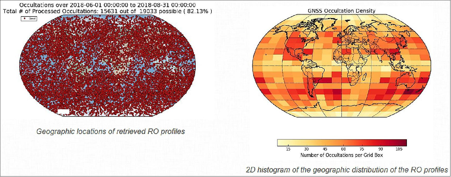

STRATOS GNSS Ionospheric Data
• Slant TEC (Total Electron Content) and S4 scintillation is collected along with RO
• Available globally, unlike land-based GNSS ionosphere measurements
• Applications include space weather monitoring, GNSS augmentation (real-time corrections).
STRATOS Ionosphere Measurements
• Top-side ionospheric information can be derived from dual frequency GNSS signals
- Slant TEC (Total Electron Content)
- Scintillation events
- Electron density profiles
• Spire currently processes over 750,000 TEC samples each day
• Expected growth to 16M TEC with 60 STRATOS payloads
- In data-denied areas
- And with low-latency
• Assimilation into upper atmospheric models for improved space weather forecasting predictions.
STRATOS GNSS Bistatic Radar (GNSS-R)
Passive bistatic radar using GNSS signals that estimates Earth surface properties through the radar scattering cross-section or delay observable.
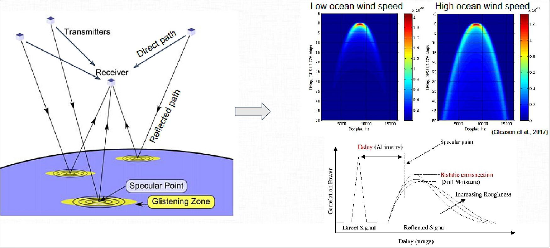
SENSE
SENSE: Each Lemur is also equipped with SENSETM, a receiver for AIS (Automatic Identification System) signal reception from ships at sea, providing worldwide tracking for maritime safety. AIS is used by sea vessels that send and receive VHF messages containing identification, position, course and speed information to allow the monitoring of vessel movements and collision avoidance as well as alerting in the event of sudden speed changes.
• AIS is globally used by maritime vessels to broadcast position information over VHF radio channels (162 MHz)
• Traditionally terrestrial tracking near ports, but satellite-AIS (S-AIS) is now used to track vessels world-wide from space
• Spire’s first commercial payload was an AIS receiver and each satellite carries this payload
• S-AIS product known as “Spire Sense”.
Maritime Domain Awareness. A Complete Understanding of Global Shipping
• Financial Services
- Accurate pulse of worlds commodity markets
• Logistics
- Port operations and supply chain optimization
• Fleet Management
- Fuel optimization, ETA , digital navigation, alert
• Oil & Gas
- Monitoring & insight into the off-shore market
• Environmental
- Monitor protected areas / polar monitoring
• Security
- Piracy identification and ship routing
• Defense
- Monitoring, identifying anomalies in EEZ zones
• Illegal Fishing
- Extend surveillance, correlate with SAR images
• Search & Rescue
- Pinpoint vessels in distress / identify nearby vessels to assist.
ADS-B (Automatic Dependent Surveillance-Broadcast)
Spire announced a second generation series of nanosatellites to be launched from 2018 onwards, which will also feature ADS-B (Automatic Dependent Surveillance-Broadcast) payloads to track airplanes (Ref. 60). 61)
• Provides aircraft’s position from GNSS (or inertial for older installations)
• Velocity, callsign, status
• Versions 0, 1 and 2 (DO-260/ED-102)
• Required in US by 2020 (DO-260B)
1090ES (1090 MHz extended squitter)
• Part of Mode-S secondary radar standard
• 112 bits (8 type/capability, 24 address,24 CRC, 56 ADS-B)
• Full position in two messages (odd/even)
• Average rate 5.2 messages per second
• Lower and upper antenna alternation
• Uniform distribution in time.
ADS-B will soon be required by most countries around the world
• Already required in HongKong, Vietnam, Sri Lanka, Singapore, Taiwan (2017), Australia (2017), and many more
• North American and Europe will require ADS-B Out by 2020
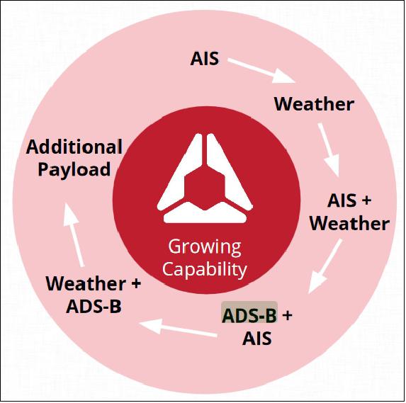
Every application reinforces all other applications
• The business behind each payload and innovation carries forward to building the next payload
- AIS led the way for weather payload
- Weather combined with AIS produces additional unique innovation
- ADS-B makes use of AIS by sharing radio
• Satellite bus supports multiple payloads at the same time
• Additional payloads (GNSS-RO, GNSS-R, High Performance Computing, etc.) all supported by the flywheel effect
Spire ADS-B Constellation
• 4 active ADS-B satellites (as of Nov. 2018)
• Four segment antenna with tilted main beam
• State of the art software-defined ADS-B/AIS receiver
• ARM Cortex-9 / Xilinx Zynq 7000
• Yocto Linux
• ADS-B demodulation in FPGA
• Messages decoding and processing in CPU
• Peak capacity 7500 messages per minute per satellite
• Antenna footprint 2.5 million km2
• Many ADS-B capable satellites to be launched in coming months
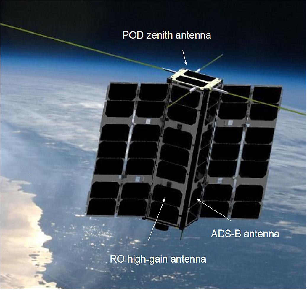
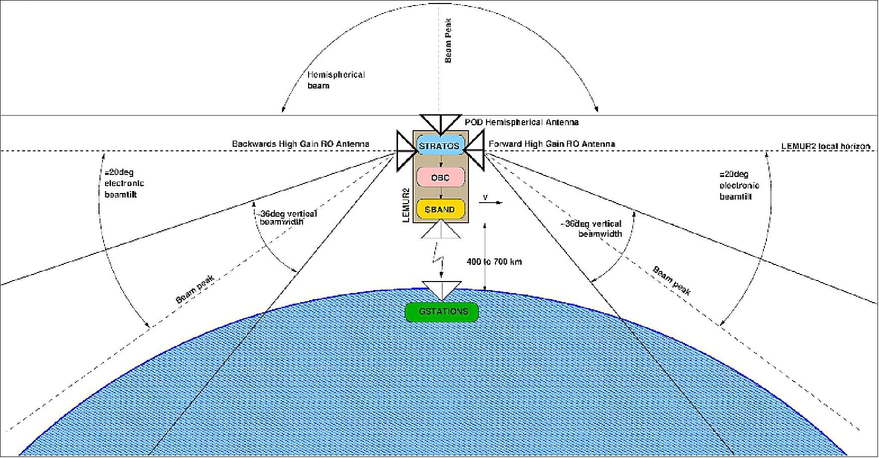
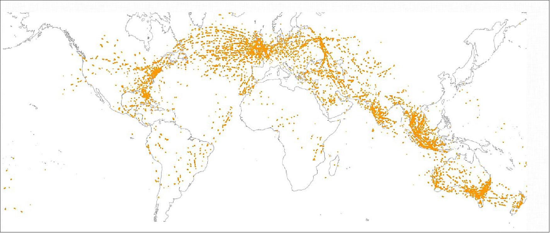
1) ”Spire Unveils Satellite To Make Weather As Predictable to Navigate As Google Maps,” Spire, Jan. 29, 2015, URL: [web source no longer available]
2) ”Rapidly Refreshed Satellite-Based Data,” Spire, URL: https://spire.com/
3) ”Spire Global,” Wikipedia, URL: https://en.wikipedia.org/wiki/Spire_Global#cite_note-GunterAS1X-7
4) ”Rapidly Refreshed Satellite-Based Data,” Spire, URL: https://spire.com/
5) ”Ball Aerospace and Spire Global Collaborate on Arctic Maritime Domain Awareness,” Spire Global, March 6, 2017, URL: [web source no longer available]
6) Jonathan Rosenblatt, Darren Garber, Darren McKnight, ”Examination of Constellation Deployments Relative to Debris Mitigation in Low Earth Orbit,” Proceedings of the 68th IAC (International Astronautical Congress), Adelaide, Australia, 25-29 Sept. 2017, paper: IAC-17-A6,10-B4.10,3
7) ”Spire Global,” URL: https://en.wikipedia.org/wiki/Spire_Global#cite_note-Spire-4
8) Gunter's Space Page,”Lemur-2,” URL: http://space.skyrocket.de/doc_sdat/lemur-2.htm
9) ”NanoRacks Completes Historic Above Space Station Cygnus CubeSat Deployment,” NanoRacks, Nov. 28, 2016, URL: http://nanoracks.com/historic-above-space-station-cygnus-cubesat-deployment/
10) Stephen Clark, ”40th flight of India’s PSLV declared a success,” Spaceflight Now, June 23, 2017, URL: https://spaceflightnow.com/2017/06/23/40th-flight-of-indias-pslv-declared-a-success/
11) Stephen Clark, ”Soyuz rocket lifts off with 73 satellites,” Spaceflight Now, July 14, 2017, URL: https://spaceflightnow.com/2017/07/14/soyuz-rideshare-launch/
12) ”PSLV Successfully Launches 31 Satellites in a Single Flight,” ISRO, 12 Jan. 2018, URL: https://www.isro.gov.in/2018press15.html
13) ”Spire Global -Satellite list,” Wikipedia, URL: https://en.wikipedia.org/wiki/Spire_Global
14) Stephen Clark, ”Cygnus cargo ship released from space station, heads for extended mission,” Spaceflight Now, 15 July 2018, URL: https://spaceflightnow.com/2018/07/15/cygnus-cargo-ship-released-from-space-station-heads-for-extended-mission/
15) Stephen Clark, ”Soyuz launches cluster of 28 satellites,” Spaceflight Now, 27 December 2018, URL: https://spaceflightnow.com/2018/12/27/soyuz-28-satellite-cluster-launch/
16) Stephen Clark, ”Soyuz rocket and Fregat upper stage deliver 33 satellites to three different orbits,” Spaceflight Now, 5 July 2019, URL: https://spaceflightnow.com/2019/07/05/soyuz-rocket-and-fregat-upper-stage-deliver-33-satellites-to-three-different-orbits/
17) Jeff Foust, ”SpaceX launches third dedicated smallsat rideshare mission,” SpaceNews, 13 January 2022, URL: https://spacenews.com/spacex-launches-third-dedicated-smallsat-rideshare-mission/
18) ”Lemur-2 (6U),” Skyrocket.de, January 2022, URL: https://space.skyrocket.de/doc_sdat/lemur-2_6u.htm
19) ”Planet Earth Gets a Thermometer: OroraTech Launches First Dedicated Satellite With SpaceX,” Orora Technologies, Press Release, 13 January 2022, URL: https://ororatech.com/ororatech-first-satellite-launch-press-release/
20) ”NanoRacks-LEMUR-2 (NanoRacks-LEMUR-2),” NASA, 24 May 2017, URL: https://www.nasa.gov/mission_pages/station/research/experiments/2349.html
21) ”Spire Global Unveils Plan to Augment its Weather Data and Forecasting with Microwave Sounders,” Spire Press Release, 20 July 2022, URL: https://ir.spire.com/news-events/press-releases/detail/120/spire-global-unveils-plan-to-augment-its-weather-data-and
22) Jason Rainbow, ”Spire adding microwave sounders to improve weather forecasts,” SpaceNews, 20 July, 2022, URL: https://spacenews.com/spire-adding-microwave-sounders-to-improve-weather-forecasts/
23) Jason Rainbow, ”Spire Global adding high-capacity Ku-band antennas to satellites,” SpaceNews, 10 May 2022, URL: https://spacenews.com/spire-global-adding-high-capacity-ku-band-antennas-to-satellites/
24) ”Spire Global to Provide Gale Force with Weather Data to Improve Maritime Vessel Performance and Reduce Carbon Emissions,” Spire Press Release, 5 May 2022, URL: https://ir.spire.com/news-events/press-releases/detail/108/spire-global-to-provide-gale-force-with-weather-data-to
25) ”Spire Global Introduces New Weather Insights Solutions for the Maritime Industry,” Spire Global Press Release, 27 April 2022, URL: https://ir.spire.com/news-events/press-releases/detail/106/spire-global-introduces-new-weather-insights-solutions-for
26) ”Spire Global, Inc. Completes Acquisition of exactEarth Ltd.,” Spire, 12 April 2022, URL: https://tinyurl.com/yc4etp8u
27) ”Spire Global Awarded $8 Million NOAA Contract to Deliver Satellite Weather Data,” Spire Press Release, 11 February 2022, URL: https://ir.spire.com/news-events/press-releases/detail/95/spire-global-awarded-8-million-noaa-contract-to-deliver
28) Debra Werner, ”Spire and SpaceChain announce on-orbit blockchain demonstration,” SpaceNews, 28 September 2021, URL: https://spacenews.com/spire-spacechain-partnership/
29) Jeff Foust, ”House committee presses NOAA on commercial weather data and space traffic management,” SpaceNews, 24 September 2021, URL: https://spacenews.com/house-committee-presses-noaa-on-commercial-weather-data-and-space-traffic-management/
30) Jason Rainbow, ”Spire snaps up exactEarth in first acquisition as a public company,” SpaceNews, 14 September 2021, URL: https://spacenews.com/spire-snaps-up-exactearth-in-first-acquisition-as-a-public-company/
31) ”Spire Global Awarded NOAA Contract to Deliver Satellite Weather Data,” Spire Press Release, 1 September 2021, URL: https://spire.com/press-release/spire-global-awarded-noaa-contract-to-deliver-satellite-weather-data/
32) ”Spire Global and Mantle Labs Announce Strategic Agriculture Intelligence Partnership,” Spire Press Release, 24 August 2021, URL: https://spire.com/press-release/spire-global-and-mantle-labs-announce-strategic-agriculture-intelligence-partnership/
33) ”Spire Global Announces Completion of Merger with NavSight Holdings,” Spire Press Release, 16 August 2021, URL: https://spire.com/press-release/spire-global-announces-completion-of-merger-with-navsight-holdings/
34) Marcia S. Smith,”Spire, GeoOptics Win First NOAA Commercial Weather Data Contracts,” SpacePolicyOnline.com, Sept. 16, 2016, URL: http://www.spacepolicyonline.com/news/spire-geooptics-win-first-noaa-commercial-weather-data-contracts
35) Jason Samenow, ”NOAA awards first-ever satellite data contracts to private industry,” Washington Post, Sept. 16, 2016, URL: https://www.washingtonpost.com/news/capital-weather-gang/wp/2016/09/16/noaa-awards-first-ever-satellite-data-contracts-to-private-industry/?utm_term=.f20614578f48
36) Caleb Henry, ”Spire CEO: We are Launching Satellites Every Month,” Satellite Today, October 26, 2016, URL: http://www.satellitetoday.com/nextspace/2016/10/26/spire-ceo-launching-satellites-every-month/
37) Debra Werner, ”Spire Global data to feed maritime-traffic algorithms,” SpaceNews, 5 October 2021, URL: https://spacenews.com/latconnect-60-to-rely-on-spire-data-for-maritime-collision-avoidance/
38) Jason Rainbow, ”Europe’s meteorological satellite agency makes first commercial data acquisition,” SpaceNews, 6 August 2021, URL: https://spacenews.com/europes-meteorological-satellite-agency-makes-first-commercial-data-acquisition/
39) ”Spire Global, Inc. Announces Preliminary First Half 2021 Selected Financial Results, Provides Updated Guidance for 2021,” Businesswire, 29 July 2021, URL: https://www.businesswire.com/news/home/20210729005639/en/Spire-Global-Inc.-Announces-Preliminary-First-Half-2021-Selected-Financial-Results-Provides-Updated-Guidance-for-2021
40) ”NASA Extends Contract with Spire Global for Satellite Data,” NASA, 14 July 2021, URL: https://earthdata.nasa.gov/learn/articles/spire-contract-extension
41) ”Spire Maritime Announces Expansion of Data Analytics with New Platform and Features - Spire Bridge will bring customer solutions under a single platform. Spire Analytics will deliver actionable insights for your decision-making process,” Spire, 29 April 2021, URL: https://spire.com/press-release/spire-maritime-announces-expansion-of-data-analytics-with-new-platform-and-features/
42) Jason Rainbow, ”Spire Global joins rush to public markets with $1.6 billion SPAC deal,” SpaceNews, 1 March 2021, URL: https://spacenews.com/spire-global-joins-rush-to-public-markets-with-1-6-billion-spac-deal/
43) ”Spire Announces Data Contract with European Maritime Safety Agency,” Spire Press Release, 18 February 2021, URL: https://spire.com/press-release/spire-announces-data-contract-with-european-maritime-safety-agency/
44) ”Orbitare selects Spire’s Orbital Service to launch their innovative IP communications service,” Spire Press Release, 1 February 2021, URL: https://spire.com/press-release/orbitare-selects-spires-orbital-service-to-launch-their-innovative-ip-communications-service/
45) ”ZeroNorth and Spire Maritime partner to reduce emissions in shipping,” Spire Press Release, 26 January 2021, URL: https://spire.com/press-release/zeronorth-and-spire-maritime-partner-to-provide-easy-access-to-market-leading-ais-and-weather-data/
46) Debra Werner, ”GeoOptics and Spire Global win NOAA weather data contracts,” SpaceNews, 23 November 2020, URL: https://spacenews.com/noaa-awards-first-ro-contracts/
47) ”Spire's machine-learning capable nanosat,” ESA Applications, 28 September 2020, URL: https://www.esa.int/Applications/Telecommunications_Integrated_Applications/Machine-learning_nanosats_to_inform_global_trade
48) ”UK Space Agency: Take-off for UK-built supercomputer nanosatellites,” WiredGov, 29 September 2020, URL: https://www.wired-gov.net/wg/news.nsf/articles/UK+Space+Agency+Takeoff+for+UKbuilt+supercomputer+nanosatellites+29092020154300?open
49) Debra Werner, ”Spire unveils weather product for maritime customers,” SpaceNews, 11 September 2019, URL: https://spacenews.com/spire-forecast/
50) ”Spire Global and Kleos Space Engage in Technology Association for Maritime Safety,” Satnews Daily, 14 August 2019, URL: http://www.satnews.com/story.php?number=686817598
51) ”Pioneer satellites launched,” ESA Telecommunications & Integrated Applications, 5 July 2019, URL: http://www.esa.int/Our_Activities/Telecommunications_Integrated_Applications/Pioneer_satellites_launched
52) Debra Werner, ”Exolaunch preparing eight Spire Lemurs for Soyuz flight,” Space News, 6 June 2019, URL: https://spacenews.com/exolaunch-eight-spire-cubesats/
53) ”Spire Global And BAE Systems To Power Geospatial eXploitation Products™ With AIS Data,” Spire Global, 1 May 2019, URL: https://www.globenewswire.com/news-release/2019/05/01/1813582/0/en/Spire-Global-And-BAE-Systems-To-Power-Geospatial-eXploitation-Products-With-AIS-Data.html
54) Elizabeth Howell, ”Satellite Company Spire Sees High Growth Amid A Crowded Market,” Forbes, 5 April 2019, URL: https://www.forbes.com/sites/elizabethhowell1/2019/04/05/satellite-company-spire-sees-high-growth-amid-a-crowded-market/#2e9a3bd94f52
55) ”Spire data familiarization phase for the Earthnet Third Party Mission program,” ESA, 21 November 2018 [web source no longer available]
56) Steve Cole, ”NASA Evaluates Commercial Small-Sat Earth Data for Science,” NASA Release 18-086, 04 October 2018, URL: https://www.nasa.gov/press-release/nasa-evaluates-commercial-small-sat-earth-data-for-science
57) Jeff Foust, ”Three companies win NOAA commercial weather data pilot contracts,” Space News, 20 September 2018, URL: https://spacenews.com/three-companies-win-noaa-commercial-weather-data-pilot-contracts/
58) Debra Werner, ”Spire Global is expanding cubesat constellation to offer persistent global view,” Space News, 10 Jan. 2018, URL: http://spacenews.com/spire-global-is-expanding-cubesat-constellation-to-offer-persistent-global-view/
59) AMS (American Meteorological Society) 98th Annual Meeting, Austin, Texas, USA, 7-11 January 2018, URL: https://ams.confex.com/ams/98Annual/meetingapp.cgi
60) Dallas Masters, ”Seizing Opportunity:Spire’s CubeSat Constellation of GNSS, AIS, and ADS-B Sensors,” Stanford PNT (Positioning, Navigation, and Timing) Symposium, 7-8 November 2018, URL: http://web.stanford.edu/group/scpnt/pnt/PNT18/presentation_files/I07-Masters-Spire_GNSS_AIS_ADS-B.pdf
61) Jeff Foust, ” Spire to enter aviation tracking market,” Space News, 6 December 2016, URL: https://spacenews.com/spire-to-enter-aviation-tracking-market/
62) Lentz Danny, "SpaceX Transporter-8 launches 72 payloads marking 200th booster landing", NSF (Nasa Space Flight), June 12, 2023, URL: https://www.nasaspaceflight.com/2023/06/spacex-transporter-8/
63) Gunter’s Space Page, “Lemur-2”, URL: https://space.skyrocket.de/doc_sdat/lemur-2.htm
64) Gunter’s Space Page, “Lemur-2 (6U)”, URL: https://space.skyrocket.de/doc_sdat/lemur-2_6u.htm
65) SpaceX, “Transporter-3 Mission“, January 13, 2022, URL: https://www.spacex.com/launches/transporter-3-mission/
66) SpaceX, “Transporter-5 Mission“, May 25, 2022, URL: https://www.spacex.com/launches/transporter-5/
67) SpaceX, “Transporter-8 Mission“, June 12, 2023, URL: https://www.spacex.com/launches/mission/?missionId=transporter-8
68) SpaceX, “Transporter-6 Mission“, January 3, 2023, URL: https://www.spacex.com/launches/mission/?missionId=transporter-6-pl
69) SpaceX, “Transporter-7 Mission“, April 14, 2023, URL: https://www.spacex.com/launches/mission/?missionId=transporter-7-pl
70) Todd, David, “Rocketlab launches Electron KS for satellite transport and first stage splashdown test”, Seradata, July 19, 2023, URL: https://www.seradata.com/rocketlab-launches-electron-ks-for-satellite-transport-and-first-stage-splashdown-recovery-test/
71) Gongora, “SpaceX F9 : Transporter-9 Rideshare : Vandenberg : 11 November 2023 (18:49 UTC)”, NasaSpaceFlight, March 6, 2024, URL: https://forum.nasaspaceflight.com/index.php?topic=56359.0
72) SpaceX, “Transporter-9 Mission”, November 11, 2023, URL: https://www.spacex.com/launches/mission/?missionId=transporter-9
73) SpaceX, “Transporter-10 Mission”, March 4, 2024, URL: https://www.spacex.com/launches/mission/?missionId=transporter10
74) N2YO.com, “LEMUR SATELLITES”, URL: https://www.n2yo.com/satellites/?c=49
75) Corbett, Tobias, “Rocket Lab kicks off 2024 with “Four of a Kind” satellite mission”, NasaSpaceFlight, January 30, 2024, URL: https://www.nasaspaceflight.com/2024/01/four-of-a-kind/
76) Spire, “Spire Global Launches Seven LEMUR Satellites on SpaceX Transporter-11 Mission”, August 16, 2024, URL: https://ir.spire.com/news-events/press-releases/detail/231/spire-global-launches-seven-lemur-satellites-on-spacex
77) Nanosats Database, “Lemur-2 Satellites”, URL: https://www.nanosats.eu/sat/lemur-2
Spacecraft Launches Mission Status Sensor Complement References Back to Top